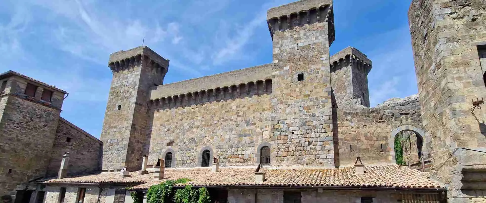
Volcanic Basalt and Papal Hegemony: The Defensive Urbanism of Rocca Monaldeschi and Montefiascone Citadel
Rising from the fractured rim of Europe’s largest volcanic caldera, the fortresses of Bolsena and Montefiascone represent a singular convergence of geological fortune and geopolitical calculation. Basalt and trachytic tufa quarried from Vulsini eruptions millions of years old, papal ambitions stretching from Innocent III to Julius II, and a military engineering tradition transformed by gunpowder all converge in this volcanic lakeland of High Tuscia. This study examines the material logic, construction history, and strategic programme of two fortifications that sustained papal sovereignty over central Italy for three centuries and bequeathed to the region an architectural legacy inseparable from its igneous substrate.
Key Takeaways
- The Vulsini volcanic complex — source of Europe’s largest volcanic lake — produced the caldera rim that both furnishes the elevated positions exploited by Bolsena and Montefiascone and yielded the basalt and trachytic tufa from which both fortresses were constructed.
- The Rocca Monaldeschi della Cervara was initiated in 1295 by the commune of Orvieto, which raised the main tower and northern curtain wall; the Monaldeschi family completed the four-tower trapezoidal enclosure across the fourteenth and early fifteenth centuries before the city reverted to direct Church control around 1449.
- The Montefiascone Citadel was established by Pope Innocent III on the caldera rim at 633 metres above sea level in the late twelfth or early thirteenth century; during the Avignon captivity it served as the political capital of the entire Patrimony of Saint Peter in Tuscia.
- Antonio da Sangallo the Elder drew gunpowder-adaptation plans for the Montefiascone Citadel in the late fifteenth century; his nephew Antonio da Sangallo the Younger completed the major restructuring in 1519, placing the fortress at a documented waypoint in the development of the trace italienne in Lazio.
- Both fortresses illustrate the material logic of volcanic construction: basalt’s exceptional compressive strength and near-impermeability made it ideal for thick curtain walls and rainwater-collecting cisterns, while lighter trachytic tufa served interior facing and carved architectural detail.
- Kumamoto Castle in Japan and high-Andean Inca masonry traditions independently developed slope-adaptive stone walls in volcanic and igneous materials, demonstrating convergent structural responses to the volcanic upland site type across unconnected civilisations.
People Also Ask About Fortress Architecture and Volcanic Geology in High Tuscia
What volcanic materials did medieval builders use for fortress construction around Lake Bolsena?
The primary structural material for fortifications around Lake Bolsena was basalt and trachytic tufa produced by the Vulsini volcanic complex, the same eruptive system that shaped the caldera now filled by the lake. Basalt — an igneous rock of very high compressive strength and low porosity — was the preferred material for load-bearing curtain walls and tower bases, where mass and impermeability mattered most. The local trachytic tufa (known in this region variously as nenfro or peperino, depending on precise composition) is lighter and more amenable to iron-tool dressing, and builders reserved it for interior coursing, door surrounds, and carved architectural detail. Medieval masons working in the thirteenth through fifteenth centuries could source both materials from caldera-rim outcrops without long-distance transport, exploiting the natural joint and fracture patterns that volcanic cooling and subsequent seismic activity had introduced into the rock mass. Where lime mortar was used — as was standard for Italian medieval military construction — the volcanic silica and alumina present in the local sands would have contributed a degree of pozzolanic reactivity, enhancing durability in the exposed, humid caldera environment.
How did papal authority shape the fortification of High Tuscia from the twelfth to sixteenth centuries?
Papal authority in Tuscia expressed itself through a sustained programme of fortress-building that used military architecture as a direct instrument of territorial governance. Pope Innocent III established the Montefiascone Citadel on the caldera rim in the late twelfth or early thirteenth century, selecting a volcanic height commanding both the lake basin and the Via Cassia below. Subsequent popes — including Gregory IX, Nicholas III, Urban IV, Martin IV, and John XXII — each added to the Montefiascone structure, cumulatively transforming it into the political capital of the Patrimony of Saint Peter in Tuscia during the Avignon captivity of 1309 to 1377. Cardinal Egidio Albornoz’s campaigns of the 1350s, codified in the Constitutiones Aegidianae of 1357, formally designated Montefiascone as the seat of the Rector of the Patrimony, underscoring the administrative weight that the fortress carried. The Rocca Monaldeschi at Bolsena, initiated under Orvietan authority in 1295 and completed by the Monaldeschi as vicars of the Church, followed a parallel logic: command of the lakeshore approach required a fortified acropolis above the town, anchored to the caldera topography and built from the same igneous materials that the volcano had provided.
What is the plan and structural character of the Rocca Monaldeschi della Cervara at Bolsena?
The Rocca Monaldeschi della Cervara adopts a trapezoidal plan with four square towers at its corners, each linked by curtain walls that carry a merlated parapet walk. Construction proceeded in at least two documented phases: the commune of Orvieto raised the main tower — the mastio or Torre Maggiore, approximately thirty metres in height — and the northern curtain wall in 1295; the Monaldeschi family then added three further towers and the remaining walls across the fourteenth and early fifteenth centuries. The mastio is the dominant element of the composition and offered the primary lookout position across the lake surface. A macchicolated gallery survives largely intact above the curtain walls and can be walked in full by visitors today. One structurally significant observation is that the curtain walls of the Rocca as they survive show limited evidence of a pronounced battered-base profile — the scarpatura or splayed footing that is characteristic of purely military fortifications from this period — a condition attributed to the gradual reorientation of the building’s function from strictly defensive to partially residential as the Monaldeschi consolidated civil, rather than purely martial, control over Bolsena.
How did the Sangallo architects adapt the Montefiascone Citadel for gunpowder artillery?
The adaptation of the Montefiascone Citadel for gunpowder artillery unfolded across two Sangallo generations in the late fifteenth and early sixteenth centuries. Toward the close of the fifteenth century, the Papal See commissioned a systematic programme of military upgrades to its Tuscia fortress network, and Antonio da Sangallo the Elder — the period’s foremost papal military engineer, with documented work also at Arezzo and in Rome — drew restructuring plans for Montefiascone specifically to accommodate the new ballistic realities introduced by cannon. This meant substantially thicker walls to absorb bombardment, and reorganised gun positions capable of delivering flanking fire along exposed wall faces. Pope Julius II ordered the continuation of this work in the early sixteenth century, and Pope Leo X subsequently entrusted the project’s completion to Antonio da Sangallo the Younger, who restructured the fortress in 1519. This 1519 campaign preceded the younger Sangallo’s fully developed pentagonal bastion designs by more than a decade, placing it in the transitional phase of the trace italienne, when wall-thickening and the repositioning of gun platforms were the primary tools of adaptation rather than the complete geometric redesign of the bastion system that would follow.
Extended multi-day tours – 5+ days
Featured Lazio Marche Abruzzo Multi-Day Tour Packages
5 days
5 Day Rome Self Guided: Discover the Eternal City
- ✓ Comprehensive Lazio Marche Abruzzo tour
- ✓ Expert local guides included
- ✓ All accommodation arranged
- ✓ Transportation provided
3 days
Rome City Break – 3 Days/2 Nights
- ✓ Comprehensive Lazio Marche Abruzzo tour
- ✓ Expert local guides included
- ✓ All accommodation arranged
- ✓ Transportation provided
9 days
Paris & Rome: Magical Duo
- ✓ Comprehensive Lazio Marche Abruzzo tour
- ✓ Expert local guides included
- ✓ All accommodation arranged
- ✓ Transportation provided
4 days
The Best Of Rome: 4 Days Adventure
- ✓ Comprehensive Lazio Marche Abruzzo tour
- ✓ Expert local guides included
- ✓ All accommodation arranged
- ✓ Transportation provided
Multi-day tour packages powered by TourRadar. Prices and availability subject to change.
The Volcanic Foundation of Military Architecture in High Tuscia
The fortification of High Tuscia was never a purely political decision. Before the commune of Orvieto selected a ridge above Bolsena for its 1295 building campaign, before the papacy chose the hill of Montefiascone for its administrative capital in central Italy, the land itself had already organised the strategic options available. The Vulsini volcanic complex, spanning approximately 2,200 square kilometres in northern Lazio, had spent several hundred thousand years constructing the most defensible terrain in the region — a broad caldera some sixteen kilometres across, its rim rising to between three hundred and more than six hundred metres above the lake that now fills it, the entire circuit visible from any elevated point on the rim itself. The communities that chose to build fortresses on that rim were not exercising free imagination; they were reading the geology.
The lake basin that became Lake Bolsena formed through repeated episodes of caldera collapse associated with the Vulsini eruptions between roughly 600,000 and 200,000 years ago. Roman historical records attest to volcanic activity as recently as 104 BC, though the complex has been dormant since. The caldera’s two internal islands — Bisentina and Martana, in the lake’s southern half — are remnants of underwater eruptive cones that rose through the caldera floor following the principal collapse event, visible reminders of the geological violence that shaped this landscape. The lake is now fed entirely by aquifer discharge, rainfall, and surface runoff, with a single outlet at Marta on the southern shore, but its volcanic origin is written in every cliff face, every road cut, and every fortress wall in the surrounding towns.
High Tuscia — the Latin name for the territory now corresponding to the province of Viterbo — sits at the intersection of several historical imperatives that converged with particular force in the volcanic highlands north of Rome. The Via Cassia, one of the principal consular roads connecting Rome to northern Italy, traversed the region from south to north, passing through Viterbo, Montefiascone, and Bolsena before ascending toward Acquapendente and the Apennine crossings. Any power that controlled the caldera rim also controlled this road. For the medieval papacy — chronically challenged by the noble families of Latium, the ambitions of the Holy Roman Empire, and the turbulence of its own civil administration — translating theological authority into territorial reality required exactly the kind of fortified highland strongholds that the Vulsini geology provided ready-made.
The building materials offered by the volcanic landscape were themselves a military advantage. Basalt quarried from the caldera rim is among the hardest common building stones in Europe, with a compressive strength typically exceeding 200 megapascals — roughly four to six times that of the limestone or travertine used for comparable structures in Rome or Umbria. Trachytic tufa, lighter and more tractable under the chisel, could be worked into the ashlar courses and carved detail that gave papal fortresses their architectural identity without requiring the skilled long-distance transport chains that imported stone would have demanded. The same volcanic aquifer system that filled the caldera also ensured reliable groundwater in the surrounding terrain, while the lake itself and the seasonal rains that the elevated rim intercepted made rainfall-harvesting cisterns a practical source of siege-water for any garrison prepared to quarry them into the basalt bedrock. In this landscape, the military architect and the geologist were reading the same text.
The political context that set builders to work on this geological foundation was the expansion and consolidation of the Papal States across the thirteenth and fourteenth centuries. The Patrimony of Saint Peter in Tuscia — essentially the territory of the modern province of Viterbo — was one of the core provinces of the medieval papal dominions, bordered by the Duchy of Spoleto, the March of Ancona, and the Duchy of Tuscany, and contested at various moments by the communes of Orvieto and Viterbo, by the Visconti and Colonna families, and by imperial claimants. The fortification of the caldera rim towns was not merely defensive in the passive sense; it was a statement of sovereignty, a material argument that the Church’s territorial claims were backed by stone and garrison, not merely by canon law and papal bull.
The Vulsini Caldera Rim: Geology as Military Geography
To understand why the fortresses of Bolsena and Montefiascone were placed where they are, and why they were built the way they were, it is necessary to understand the shape of the caldera they sit on. The Bolsena caldera is not a simple circular depression: it is an irregular volcanic basin whose rim varies in height from roughly 300 metres at Bolsena on the northeastern shore to more than 630 metres at Montefiascone on the southern ridge. This asymmetry reflects the complex eruptive history of the Vulsini system, which produced multiple collapse events rather than a single dramatic implosion, and left a rim with multiple defensive peaks.
Bolsena itself occupies a position at approximately 350 metres above sea level on the northeastern shore, where the caldera rim drops toward the lake in a series of basalt-capped terraces. This lower rim elevation is compensated by the proximity of the town to the lake and to the Via Cassia, which ran along the lakeshore here. The Rocca Monaldeschi della Cervara was built on the highest point of the town’s urban acropolis, rising above the medieval street grid to command both the lake to the west and the agricultural hinterland to the east. From the mastio’s summit at approximately sixty metres above the town’s main square, a garrison could observe vessel traffic on the entire northern arm of the lake, identify approaching forces on the road from Viterbo and Orvieto, and potentially signal to fortified positions on the opposite shore — a consideration that the caldera’s visual geometry made more practical here than at almost any other comparable site in Lazio.
Montefiascone occupies the opposite extreme of the caldera’s altitudinal range. The hill of Montefiascone, known in ancient sources as Colle Falisco, rises to 633 metres on the southern rim of the basin, placing it nearly 300 metres above the lake surface and commanding a panoramic view that encompasses the full extent of the water, both islands, and all the rim settlements from Marta and Capodimonte in the southwest to Bolsena and Grotte di Castro in the north and east. From this position, which Roman-period sources identify as already fortified, the medieval papal citadel dominated not only the lake corridor but also the approach to the Tyrrhenian coastal plain — a strategic reach that no lowland position could have replicated.
The geological materials available at these two contrasting elevations differ in character even though they derive from the same volcanic system. At Bolsena’s lower rim, the accessible outcrops include both basalt lava flows — the product of effusive eruptions that produced the most durable stone — and thicker beds of trachytic tufa, the result of pyroclastic fall and flow deposits laid down during explosive phases of the Vulsini activity. At Montefiascone’s higher elevation, the exposed geology is dominated by older and denser volcanic products, including the nenfro tuff characteristic of the Bolsena caldera margins: a dark, fine-grained trachytic tuffite that takes a reasonably clean tool edge but is distinctly harder and more massive than the lighter tufa of lower elevations. Both sites thus offered medieval builders a choice of materials tuned to structural requirement — heavier, denser stone for the load-bearing base of curtain walls and towers, lighter material for upper coursework and interior surfaces — without requiring the builders to move either material far from source.
Structural Engineering of the Monaldeschi Fortress at Bolsena
The Rocca Monaldeschi della Cervara presents itself to the visitor as a coherent late-medieval fortification, but its walls encode a construction history that spans more than a century and at least two distinct building authorities. The fortress as it stands is a four-tower trapezoidal enclosure rising from the medieval urban ridge of Bolsena, with the Torre Maggiore — the mastio — anchoring the northwestern corner and providing the vertical emphasis that identifies the complex from the lake. The three remaining towers, smaller and of slightly different proportions, were added by the Monaldeschi family in the course of the fourteenth and early fifteenth centuries to complete the defensive perimeter that the original Orvietan campaign had left unfinished. The connecting curtain walls carry a merlated parapet walk supported on stone corbels — a distinctive feature of central Italian military architecture of the period — that survives in restored condition and offers one of the few opportunities in the Viterbo province to walk a complete medieval macchicolated circuit at height.
The structural logic of the plan reflects the defensive calculation of the late thirteenth century, when the primary threats were scaling, battering, and archery rather than gunpowder artillery. Square towers — as opposed to the round towers that would become standard in more exposed fortifications during the fourteenth century — provide strong corner flanking for the curtain between them, but create a geometrical dead zone directly beneath the tower face that a later generation of military engineers would regard as a vulnerability. The decision to build square towers at all four corners of the Bolsena enclosure situates the Rocca firmly in the tradition of communal and noble fortification as practised in northern Lazio and southern Tuscany during the period of Orvietan municipal expansion.
The mastio deserves particular attention as the oldest element of the surviving structure. Rising to approximately thirty metres above the courtyard level, it dominates not only the fortress complex but the entire urban skyline of Bolsena when seen from the lake. Its walls are constructed in the volcanic ashlar tradition characteristic of High Tuscia from the twelfth century onward: courses of roughly squared basalt blocks, variable in size but generally between forty and sixty centimetres in length, laid in courses with lime mortar joints and a rubble infill core. This construction method produces walls of substantial mass — a necessary quality when the primary projectile threat was the catapult or trebuchet rather than the cannon — and the basalt’s high density means that even a relatively thin wall section resists penetration more effectively than the same thickness in limestone or brick.
Basalt Block Extraction and Mortar Composition along Caldera Heights
The extraction of basalt for medieval fortress construction in the Bolsena caldera zone was an operation conditioned entirely by the rock’s physical character. Basalt is an aphanitic — fine-grained — igneous rock formed from rapidly cooled lava, and its mineral composition (principally plagioclase feldspar, augite, and olivine) gives it a compressive strength that exceeds most sedimentary building stones while presenting the quarryman with a material that fractures along the joints and columnar patterns produced during cooling rather than along bedding planes. In the Vulsini volcanic province, the basalt lava flows exposed on the caldera rim typically display well-developed vertical joint systems — columns and polygonal fractures produced by thermal contraction — that allowed medieval quarrymen to detach blocks of workable size using iron wedges and hammers without the need to drill or blast.
The primary quarry operation for a caldera-rim fortress involved locating an outcrop of basalt flow with accessible jointing, driving iron wedges along the natural fracture planes to liberate blocks of appropriate size, and then dressing the exposed faces to a roughly planar surface using picks and point chisels. Full ashlar dressing — the smoothed, flat-jointed finish that produces the most economical mortar use and the tightest wall section — required additional time and skill, and was typically reserved for the quoins, tower edges, and gateway surrounds where precision mattered most. The general coursework of the curtain walls was more likely laid in what Italian building historians call opera a sacco (hollow work): two faces of roughly squared stone with a rubble-and-mortar fill between them, a technique that delivered adequate structural performance at significantly lower labour cost.
The mortar that bound the Bolsena volcanic ashlar was almost certainly a lime-based composition, prepared by calcining the local limestone and mixing the resulting quicklime with sand and water in proportions that medieval masons calibrated by experience rather than formula. Where volcanic sand or pozzolanic ash was available as the aggregate — as it would have been in a region still littered with Vulsini pyroclastic deposits — the resulting mortar may have exhibited enhanced hydraulic setting properties, hardening in contact with moisture rather than requiring prolonged drying. The Roman builders of the imperial period had exploited this property systematically at sites throughout Campania and Lazio, and while no mortar analysis has been published specifically for the Rocca Monaldeschi, the geological availability of pozzolanic materials in the immediate vicinity makes their use by medieval builders plausible, if unconfirmed.
The organisation of the quarrying and lifting operation for a project the size of the Rocca Monaldeschi — an enclosure of approximately fifty by forty metres in plan, with walls estimated at two to three metres in thickness and towers rising to thirty metres — would have required a sustained supply chain from quarry face to building site over several construction seasons. The caldera rim above Bolsena offered outcrops within a few hundred metres of the building site, reducing the transport burden to ox-cart distance on terrain that, while steep, was manageable with the wheeled vehicles attested in contemporaneous communal building accounts from nearby Viterbo and Orvieto. The Orvietan building campaign of 1295 that initiated the fortress was a communal enterprise, with the material and labour resources of one of northern Lazio’s most prosperous medieval cities applied to a strategic objective that the Orvietan podestà had identified as essential to controlling the Bolsenese hinterland.
One material consideration that the basalt substrate introduced into the construction programme was the management of water within the building envelope. Basalt’s low porosity — typically below 5% by volume in the dense lava flows of the Vulsini province — means that rainwater falling on basalt wall faces runs off rather than being absorbed, reducing freeze-thaw damage to the mortar joints but concentrating run-off at wall bases and tower footings where drainage had to be actively managed. Effective drainage channels, or the incorporation of impermeable basalt courses at the lowest wall levels to prevent capillary rise of ground moisture, are technical responses to this characteristic that appear in the better-preserved fortifications of the region. The same impermeability that makes basalt a challenging wall material from a drainage management perspective also makes it exceptionally well-suited to water storage, a property that the builders of caldera-rim fortresses exploited systematically in the design of cisterns.
Defensive Sightlines: Optical Telecommunication Networks Across the Lake Rim
The visual geometry of the Bolsena caldera is unusual in the context of medieval Italian military geography: it produces a near-complete circuit of intervisibility. From any elevated point on the caldera rim — the height of a fortress tower — every other elevated position around the lake is simultaneously visible, because the circular topography of the caldera depression places all rim settlements in a mutual line of sight that no intervening ridge or valley interrupts. This is not an accident of local topography but a consequence of the caldera’s origin as a roughly symmetrical collapsed volcanic structure: the same geological event that depressed the centre also raised and exposed the rim, creating in a single process both the elevated defensive positions and the unobstructed view corridors between them.
Medieval military planners across Europe used this kind of visual connectivity as the basis for optical signalling systems — networks of fire signals by night and smoke signals by day that could relay warnings, troop movements, and enemy positions across distances of many kilometres within minutes. While no documentary source has yet been identified specifically describing a co-ordinated visual signal network around the Bolsena rim in the thirteenth or fourteenth centuries, the practice of inter-fortress fire signalling was sufficiently widespread in communal and papal Italy of this period — attested in administrative records from Umbria, Tuscany, and the Marche — that the visual infrastructure of the caldera rim would naturally have been incorporated into whatever warning system the local military administration maintained.
The geometry of the lake circuit makes the structural logic clear. From the mastio of the Rocca Monaldeschi at Bolsena, the summit of the Montefiascone Citadel is directly visible across the lake at approximately twenty kilometres distant, an unobstructed line-of-sight that daylight hours and good weather would have reduced to a matter of seconds’ communication for a fire signal strong enough to be distinguished from the reflective lake surface. Intermediate points — Gradoli on the western rim, Capodimonte on the southwestern shore, Marta at the lake outlet, the island of Bisentina — provided additional relay stations that could have subdivided the circuit into legs of ten kilometres or less, each manageable for signallers using brazier fires or large reflective surfaces. The tower network that would have supported such a system is not preserved as a distinct category of monument in the Bolsena basin, but the documentary record of Orvietan military administration in the territory — including the 1295 fortification campaign that built the Rocca Monaldeschi — includes references to sentinels and lookout posts that imply an organised surveillance system across the lakeshore settlements.
The structural implication for the mastio itself is significant. At thirty metres, the Torre Maggiore at Bolsena stands well above the urban roofline and above the tree canopy that would have surrounded the fortress on the landward side, creating a field of view that extends from the agricultural plain to the east to the full expanse of the lake to the west and south. The decision to build the mastio at this height — at substantial additional cost in stone and mortar relative to a ten-metre watchtower — makes most sense as a multi-purpose investment: it dominates the town below it politically and visually, it provides an elevated platform for close-range defence against assault, and it extends the garrison’s visual reach to the full circumference of the lake, transforming a local defensive structure into a node in a regional surveillance system whose other nodes were the fortress towers at Montefiascone, Marta, Capodimonte, and the island of Bisentina.
The contrast between the Rocca Monaldeschi’s visual reach and its physical scale is characteristic of the Orvietan building tradition in the late thirteenth century: these were not massive artillery citadels capable of sustaining extended sieges, but fortified administrative centres whose primary defence lay in surveillance, communication, and the rapid deployment of the communal militia that a sufficiently early warning could mobilise. The fortress was a node in a system, and the system was the landscape itself.
Papal Fortifications of High Tuscia: From Medieval Keep to Renaissance Artillery Citadel
The Montefiascone Citadel occupies an entirely different position in the hierarchy of military investment from the Rocca Monaldeschi at Bolsena. Where the Bolsena fortress was a communal initiative executed at the speed of municipal politics and completed over a century and a half of noble patronage, the Montefiascone Citadel was from its inception a papal enterprise, continuously resourced by the financial and organisational apparatus of the Apostolic See, and continuously updated to reflect both the political importance of the site and the evolving state of military technology. The result, after three centuries of papal intervention, was a structure that had undergone at least four distinct phases of major construction and adaptation, and that by the early sixteenth century housed within its volcanic-stone walls one of the most technically advanced artillery defences in Lazio.
The original structure was raised on the summit of Colle Falisco at 633 metres above sea level by order of Pope Innocent III, who identified Montefiascone as the key stronghold for the Patrimony of Saint Peter in Tuscia at the beginning of the thirteenth century. The site had been occupied continuously since at least the Copper Age — traces of Bronze Age, Etruscan, and Roman presence have been documented on the hill — and its strategic significance was self-evident to any commander surveying the territory from its summit: the full extent of Lake Bolsena, the roads to Viterbo and Siena, the coastal plain toward Civitavecchia, and the hills of southern Tuscany all fall within the panorama visible from the Colle Falisco height. Innocent III’s decision to build here was a territorial declaration as much as a military one, and the subsequent history of the citadel reflects the inseparability of those two dimensions in medieval papal governance.
The Avignon captivity of the papacy (1309–1377) paradoxically amplified the importance of the Montefiascone Citadel. With the popes resident in southern France, the day-to-day governance of the Papal States fell to legates and rectors operating from the Tuscia fortresses, and Montefiascone — codified by Cardinal Egidio Albornoz in the Constitutiones Aegidianae of 1357 as the seat of the Rector of the Patrimony of Saint Peter in Tuscia — became the effective capital of a territory the size of a small kingdom. Pope Urban V, who returned to Rome from Avignon in 1367 and used the Montefiascone Citadel as his summer residence from 1367 to 1370, found a fortress complex that multiple predecessors had enlarged and whose volcanic stone walls had been continuously maintained as a functioning administrative and military centre.
Adapting Medieval Towers for Early Firearms: The Wall-Thickening Campaigns
The introduction of effective gunpowder artillery into Italian warfare in the later fourteenth and early fifteenth centuries posed a structural challenge to fortifications across the peninsula that was without precedent in the engineering tradition of the medieval period. The medieval fortress was designed against a threat profile centred on scaling ladders and siege towers, battering rams and mining, catapults and trebuchets. Against these threats, height was the primary defence: towers that prevented scaling, walls too thick and high to be quickly breached by mechanical means, crenellated parapets that sheltered defenders from archery. Gunpowder artillery rendered this calculus obsolete. A cannon ball’s kinetic energy was transferred to the wall face as a compressive and shear stress rather than the distributed impact of a thrown stone, and the tall, relatively thin walls of medieval military architecture — optimised for height, not for resisting concentrated ballistic impact — were catastrophically vulnerable to sustained cannon fire.
The engineering response that Italian military architects developed across the fifteenth century is now known as the trace italienne — literally the Italian trace, a term that eighteenth-century military historians coined to distinguish the angled bastion system from the earlier round-tower curtain tradition. Its key elements were the systematic thickening and lowering of curtain walls, reducing their silhouette while increasing their mass; the replacement of round or square towers with angular projections (bastions) whose facets could direct fire along the faces of adjacent wall sections rather than leaving dead angles unexposed; and the adoption of earthen or rubble fill behind stone facings to create walls that absorbed rather than transmitted cannon impact. These changes did not happen overnight, and for much of the fifteenth century the typical Italian military building campaign involved the incremental adaptation of an existing medieval structure — adding earthen banks behind existing walls, rounding or removing the upper portions of towers to reduce their silhouette as targets, and thickening the base of curtain walls where cannon could be expected to fire — rather than the construction of a wholly new bastion trace on a clean site.
This incremental adaptation is exactly the campaign that the Montefiascone Citadel underwent in the late fifteenth and early sixteenth centuries. The Papal See, recognising that its Tuscia fortifications had been designed for a military threat environment that no longer existed, commissioned a systematic review and upgrade of the papal fortress network in the closing decades of the fifteenth century. For the Montefiascone Citadel, this programme took the form of new plans drawn by Antonio da Sangallo the Elder — documented by independent architectural historians as working on Montefiascone alongside Arezzo and other papal sites — aimed specifically at adapting the existing medieval structure to resist cannon fire and to mount cannon in return. Sangallo the Elder’s solution at Montefiascone, as at his other papal commissions, involved the substantial thickening of the existing curtain walls with added stone and earth backing, the reorganisation of artillery platforms within the courtyard to provide gun positions with adequate traverse and field of fire, and structural reinforcement of the tower bases to prevent the mining and undermining that cannon fire could prepare.
Pope Julius II’s decision to continue the Montefiascone works in the early sixteenth century — building on the Sangallo Elder framework — and Pope Leo X’s subsequent commission to Antonio da Sangallo the Younger, who completed a major restructuring of the citadel in 1519, together represent one of the more thoroughly documented cases of multi-generational military engineering evolution at a single papal site in Lazio. The 1519 Sangallo the Younger campaign is particularly significant because it falls at the transitional moment in the younger architect’s career: his later pentagonal bastion designs — the star-plan citadel at Ancona (1532), the pentagonal Fortezza da Basso in Florence (1534), and the Rocca Paolina in Perugia (1540) — were still more than a decade in the future. At Montefiascone in 1519 he was working within the established tradition of medieval-structure adaptation rather than designing from scratch, producing a citadel whose volcanic-stone walls had been progressively thickened and reinforced across three construction generations without being replaced.
The lasting architectural consequence of these campaigns can be read in the Montefiascone Citadel’s current configuration: a trapezoidal enclosure whose walls are substantially more massive than the original thirteenth-century Innocent III construction would have required for a pre-artillery threat environment, with the surviving tower — one of the original four, the others having been largely removed or incorporated into later construction — showing the dimensional transformation from slender medieval keep to the more compact, thick-walled artillery-era profile. The citadel’s position at 633 metres on the caldera rim also meant that the slope-adaptive construction characteristic of papal fortresses in volcanic upland terrain — walls whose base dimensions widen toward the ground to transfer load onto the volcanic bedrock and to resist the undermining that level-ground fortifications faced — was a structural necessity as well as a tactical advantage.
Hydraulic Resilience: Subterranean Cistern Networks within Volcanic Citadel Courts
The Achilles heel of any fortress built on an elevated volcanic rim is water. The same height that confers a commanding field of view and a defensible position above any attacker’s approach also places the garrison above the water table, dependent on surface collection and stored reserves rather than on wells or springs. This hydraulic reality was not unique to High Tuscia — it affected every hill fortress in volcanic Italy, from the Castelli Romani south of Rome to the Colli Euganei of Veneto — but it was felt with particular acuity at sites like Montefiascone, where the distance from the lake surface to the fortress summit exceeded 300 metres and any external supply line would be among the first casualties of a siege.
The engineering response was the subterranean cistern: a sealed chamber excavated into or beneath the courtyard floor, lined with hydraulic mortar to prevent seepage, and fed by channels that directed rainwater from the roofs, courtyard surfaces, and curtain-wall walks into the collection reservoir below. Cisterns of this kind are a documented standard feature of papal and noble fortifications across Lazio and Umbria from the twelfth century onward, and the volcanic materials of the High Tuscia zone were well-suited to their construction in several respects. Basalt, with its low porosity, could be cut into cistern lining blocks that were naturally nearly impermeable without additional treatment; where the excavation was made into solid trachytic tufa or into the denser basalt lava flows, the rock itself served as the cistern wall, requiring only a hydraulic mortar render on the inner face to seal minor fissures. The Vulsini volcanic terrain, with its characteristic combination of basalt caps over trachytic tufa beds, made it relatively straightforward to excavate cistern chambers into the softer tufa while capping them with more resistant basalt courses at the floor level above.
While the specific cistern configuration of the Montefiascone Citadel has not been fully documented in available published literature — the Civic Museum occupying the fortress complex today focuses primarily on the architectural evolution of the structure above ground — the hydraulic logic of the site makes subterranean water storage architecturally mandatory for any garrison that expected to sustain itself during a siege of more than a few days. The annual rainfall on the Colle Falisco summit, elevated into the more humid zone of the southern Bolsena rim, is sufficient to fill cisterns of moderate capacity through autumn and winter collection, provided that the collection surfaces are maintained and the cistern seals are intact. A garrison of the size typically assigned to papal citadels in Tuscia during the thirteenth and fourteenth centuries — perhaps forty to one hundred men-at-arms, with associated servants and provisioners — would require several hundred cubic metres of stored water for a siege of meaningful duration, a volume achievable within a courtyard of Montefiascone’s dimensions through multiple interconnected cistern chambers below the paving.
The cistern tradition in High Tuscia also intersects with the geology in a less obvious way. The Vulsini volcanic province sits above a substantial aquifer system fed by the same caldera basin that supplies Lake Bolsena, and in the lower elevations around the lake — including at Bolsena itself — the water table is close enough to the surface that wells rather than cisterns were the practical solution to fortress water supply. At Bolsena, the Rocca Monaldeschi’s courtyard is likely underlain by tufa beds at modest depth, and the general wetness of the lakeshore environment means that groundwater was never far from hand. The contrast with the summit of Colle Falisco at Montefiascone — high, exposed, and well above any accessible aquifer level — is therefore not merely a topographic difference but a hydraulic one, with direct consequences for how each fortress was engineered to sustain itself under military pressure. The Bolsena fortress, dependent partly on lakeshore proximity, and the Montefiascone Citadel, dependent wholly on captured rainwater, represent complementary rather than identical solutions to the hydraulic problem of the elevated volcanic rim.
Cross-Cultural Parallels in Volcanic Masonry Defense: Japan, the Andes, and High Tuscia
The volcanic upland site type — elevated, composed of locally available igneous stone, commanding a valley or coastal plain below — was not a challenge faced uniquely by the military architects of medieval Lazio. In Japan, in the high Andes, and in other volcanic upland regions across the world, builders engaged with analogous combinations of steep terrain, igneous building material, and the structural imperative of defending a commanding height against a capable adversary. The resemblances that emerge from this comparison are the product of convergent independent development — similar physical problems generating similar engineering responses without any historical connection between the traditions — and they illuminate, by contrast, the specific choices that High Tuscia’s builders made within the range of possible solutions.
Kumamoto Castle, constructed in the early seventeenth century under the direction of Katō Kiyomasa on the volcanic plains of Kyushu, stands as the most technologically elaborated example of Japanese castle stone wall construction, the ishigaki tradition. The stone walls of Japanese shiro were not mortared ashlar in the European sense: they were built in the ishigaki technique of fitted irregular or lightly dressed stones, their stability derived from careful interlocking rather than from the binding of mortar, and their profiles designed not to the straight vertical or battered European scarpa but to the elegantly curved terakobai — a wall face that begins at a moderate batter near the base and steepens progressively toward the vertical as it rises, producing the distinctive concave-convex silhouette that characterises the finest Japanese castle walls. The intention of the terakobai profile was to produce a surface that was structurally stable under its own weight — the curved profile distributes the wall’s mass in a way that compensates for the absence of mortar binding — and that defeated the grapnel and rope by the steepening of the upper slope, earning the technique the name musha-gaeshi (warrior-repelling) at Kumamoto. Crucially, Kumamoto Castle’s ishigaki walls were built from an unusual local volcanic rock, documented as producing particularly steep and technically demanding wall sections, connecting the Japanese castle tradition directly to the same volcanic material logic that underlies the Tuscia fortresses.
The differences between the Japanese and European traditions are as instructive as the similarities. Japanese castle walls evolved in an environment where the primary military threat was infantry assault — scaling, grappling, and direct attack on gate complexes — and where gunpowder artillery was introduced late and adopted slowly relative to the European experience. European curtain walls, particularly the post-Sangallo tradition represented at Montefiascone, evolved in response to cannon, demanding thicker walls, lower profiles, and angular bastion geometries. The terakobai’s elegant curve answers infantry; the battered scarp and the artillery bastion answer the cannon ball. Both extract their structural vocabulary from the volcanic material, but they answer different questions. The convergence lies upstream of the specific threat: in the shared recognition that steep terrain and igneous stone, combined by a volatile geology, produce a defensive site type with specific structural requirements that mortar-and-ashlar construction alone cannot fully address.
The Andean dimension of this comparison requires care. The Inca masonry traditions of the high Andes — attested at Sacsayhuamán, at Machu Picchu, and at dozens of other highland sites — represent a third independent tradition of slope-adaptive construction in locally available igneous and metamorphic stone. Inca polygonal masonry, with its interlocking multi-faceted blocks fitted without mortar to tolerances that continue to impress structural engineers, was developed primarily in response to the seismic environment of the Andean volcanic belt rather than to a human military threat, but its structural principles — mass, interlocking, and the exploitation of natural stone fracture patterns — overlap substantially with those of both the European ashlar and the Japanese ishigaki traditions. At high-altitude Andean sites where andesite and granite were the available materials, Inca builders developed the same capacity to read the natural joint and fracture systems of the local igneous rock and to exploit them for material extraction without the iron-wedge technology that European and Japanese quarrymen used.
What the three traditions share is the primary architectural argument: the volcanic or igneous upland site is not a constraint to be worked around but a resource to be exploited. Height is defence; local stone is structural economy; the volcanic fracture system is the quarryman’s ally. In High Tuscia, in Kyushu, and in the Andean highlands, military builders reached this conclusion independently, expressed it in materials and forms specific to their geological setting and their strategic context, and produced three of the world’s most distinctive regional traditions of stone military architecture as a result. The volcanic landscape did not determine what would be built on it — human history, political circumstance, and engineering imagination had irreducible roles in every case — but it shaped the range of choices available in ways that are legible across three continents.
The Patrimony of Saint Peter: Fortification as Administrative Territory
The fortresses of High Tuscia did not stand alone as isolated military structures. They were nodes in a territorial administration that the medieval papacy had constructed over several centuries, and their architectural character — the siting, the scale, the progressive investment in successive building campaigns — reflects the administrative logic of the Patrimony of Saint Peter as clearly as any chancery document. Understanding what the Montefiascone Citadel was requires understanding what the Patrimony was.
The Patrimony of Saint Peter in Tuscia was the northernmost of the core provinces of the medieval Papal States, a territory corresponding broadly to the modern province of Viterbo. Its borders were drawn by the interplay of papal grant, imperial concession, and armed occupation across the tenth through twelfth centuries, and by the thirteenth century it was administered by a rector — typically a cardinal or senior ecclesiastical official — who governed from a principal seat in the province. Pope Innocent III reorganised the expanded Papal States into four primary provinces around 1200, designating the Patrimony as a distinct administrative unit with its own rector and its own courts. It was Innocent III who also built the Montefiascone Citadel, in a single act that simultaneously secured the province’s principal highland stronghold and established the building type that would serve as the rector’s residence and symbol of office for the next three centuries.
The role of Cardinal Egidio Albornoz in the mid-fourteenth century represents the high-water mark of this administrative-military programme. Sent by the Avignon papacy in 1353 as legate to reconquer the Papal States from the noble families and communal governments that had seized effective control during the popes’ French residence, Albornoz conducted a systematic campaign of military restoration across central Italy that resulted in the Constitutiones Aegidianae of 1357 — a comprehensive legal and administrative framework for the governance of the Papal States that remained in force, with modifications, until the Napoleonic period. Within this framework, Montefiascone was designated one of the two seats of the Rector of the Patrimony (alongside Viterbo), confirming the citadel’s role as the administrative as well as military centre of the province. Albornoz’s campaigns also involved the construction or refurbishment of fortress networks throughout Umbria and Lazio — the Rocca Albornoz at Viterbo being his most prominent Tuscia contribution — that collectively transformed the fortress from a purely defensive structure into the physical infrastructure of papal territorial sovereignty.
The Bolsena fortress, though technically outside the direct papal chain of command for much of its history — administered first by Orvietan communal authority and then by the Monaldeschi as papal vicars — operated within this territorial system as a subordinate but important node. The Monaldeschi family’s relationship with the papacy was characterised by the ambiguity typical of late medieval Italian noble-ecclesiastical relations: nominally papal vicars, formally subordinate to the Church’s territorial authority, but in practice wielding near-sovereign power over their local territory until the extinction of the Cervara branch rendered the question moot in 1449. The Rocca Monaldeschi’s architectural evolution — from the relatively austere military tower of 1295 to the increasingly palatial complex that the Monaldeschi counts inhabited through the fifteenth century — reflects this ambiguity: a fortress that was simultaneously a defensive installation, a residence, and a statement of noble authority exercised under papal licence.
After 1449, when Bolsena reverted to direct Church control, the fortress complex shifted permanently toward the institutional and residential functions that it exercises today as the seat of the Territorial Museum of Lake Bolsena. This trajectory — from military stronghold to administrative centre to museum — follows the pattern set by the Montefiascone Citadel, sold to Cardinal Barbarigo toward the end of the seventeenth century, stripped of building materials for the Montefiascone Seminary, confiscated by the new Italian state in 1870, and subsequently transferred to the municipality as the seat of the Civic Museum and the Museum of Architecture of Antonio da Sangallo the Younger. Both fortresses completed their transformation from papal instruments of territorial control to civic heritage institutions within the same long arc of post-medieval Italian history.
Destruction, Survival, and Restoration: The Long Afterlife of Two Volcanic Fortresses
Neither fortress has arrived at its current condition intact. Both have sustained damage, alteration, and varying periods of neglect across five centuries of post-medieval history, and the restoration campaigns of the twentieth century that produced the presentable and accessible structures visible today were in each case the latest instalment in a longer history of survival and adaptation.
The Rocca Monaldeschi della Cervara suffered most severely in the sixteenth and seventeenth centuries. Following the return of Bolsena to direct Church control in 1449, the fortress passed through periods of use as a garrison installation and as a prison — a fate typical of decommissioned noble fortresses throughout the former Papal States — before being damaged by earthquake and by the passing of the Lanzichenecchi (the German mercenaries of Charles V’s imperial army) during the Italian Wars. Subsequent periods of neglect allowed vegetation to establish itself in the mortar joints and the courtyard, accelerating the deterioration of the volcanic ashlar. Antipapal sentiment in Bolsena during the Napoleonic period produced further damage, reportedly deliberate, to the structure’s upper elements. By the early twentieth century the fortress was in partial ruin, and its restoration to the coherent state visible today required a sustained programme of work across the second half of the twentieth century, including a major campaign in the 1970s that consolidated the curtain walls and rebuilt the macchicolated parapet in forms consistent with the surviving medieval evidence.
It was during this restoration, in 1973, that excavation at the base of the Torre Maggiore revealed a butto — a medieval waste disposal shaft — containing ceramic fragments datable to the fourteenth century, with material from Orvietan and Viterbese workshops of the period 1300 to 1450. The discovery provided direct material evidence for the occupation of the fortress during the Monaldeschi period, confirming the construction chronology that the documentary sources implied and adding a tangible link to the daily life of the garrison and household that the Rocca had once sheltered.
The Montefiascone Citadel’s post-medieval history was even more turbulent. The seventeenth-century sale to Cardinal Barbarigo resulted in the partial demolition of the fortress fabric, with dressed stone and architectural elements removed for reuse in the construction of the Montefiascone Seminary — a form of architectural spoliation common throughout the Papal States wherever a decommissioned fortress happened to provide convenient quarried stone. Three of the original four towers were substantially reduced or destroyed during this process, leaving only the one surviving tower — climbable today for its panoramic view of the lake — as a remnant of the original Innocent III and subsequent papal campaign structure. The Italian state’s confiscation of the property in 1870, following the unification of Italy and the absorption of the Papal States, transferred the citadel to civic ownership, though meaningful conservation investment was slow to materialise. The establishment of the Civic Museum of Montefiascone within the surviving fortress fabric, followed by the Museum of Architecture of Antonio da Sangallo the Younger, has converted the complex into one of the most architecturally specific heritage sites in Lazio — a museum dedicated, in part, to the very architectural figure whose work transformed the fortress in 1519.
Visiting Rocca Monaldeschi della Cervara and the Montefiascone Citadel
Both fortress complexes are open to visitors and function as active heritage museums, accessible as part of a single itinerary that takes in the full Bolsena caldera circuit — a route of approximately fifty kilometres that passes through Bolsena, Montefiascone, Marta, and Capodimonte, all connected by regional roads skirting the lake. A day itinerary focused on the two fortresses is achievable by car, with the drive between Bolsena and Montefiascone taking approximately twenty minutes via the SP Cassia Cimina or the lake-edge route through Marta.
At Bolsena, the Rocca Monaldeschi della Cervara houses the Territorial Museum of Lake Bolsena, which occupies the fortress’s three principal levels and the adjacent Monaldeschi Palace across the square. The museum’s collections span the geological and human history of the Bolsena basin from the Copper Age through the medieval period, with particular strength in Etruscan and Roman material from the excavation of ancient Volsinii. The restored macchicolated parapet walk offers the most direct architectural experience of the fortress structure, and the view from the mastio’s upper level across the lake to the Montefiascone rim is among the finest in the province of Viterbo. Opening hours and admission details are available from the official Bolsena municipal website, as seasonal variations apply.
At Montefiascone, the citadel complex — housing the Civic Museum and the Museum of Architecture of Antonio da Sangallo the Younger — provides a complementary experience focused on the Sangallo military engineering tradition and the broader architectural history of the Patrimony of Saint Peter. The surviving tower can be climbed for the panoramic caldera view that made Colle Falisco the strategic prize of High Tuscia for eight centuries. The museum collections include architectural drawings, models, and documentation related to Sangallo the Younger’s work in the region, making Montefiascone a particularly rewarding destination for visitors with a specific interest in Renaissance military engineering.
The two sites are best visited in the order that the geological and historical sequence suggests: begin at Montefiascone, whose position on the southern caldera rim offers the widest panoramic context for understanding the visual geography that determined the fortress placement; then descend to Bolsena for the closer, more intimate experience of the lakeshore town and its four-tower Rocca. The route between the two passes through Marta and Capodimonte, where the caldera’s southern lakeshore character — quieter, less visited, and distinctly different in feel from the busier northern reaches — provides an atmospheric transition between the two architectural experiences.
Frequently Asked Questions
What is the Rocca Monaldeschi della Cervara and where is it located?
The Rocca Monaldeschi della Cervara is a late-medieval fortress complex located in the historic centre of Bolsena, on the northeastern shore of Lake Bolsena in the province of Viterbo, northern Lazio. It takes its name from the Monaldeschi della Cervara — a branch of the powerful noble family that dominated the Orvieto region in the medieval period — who controlled the town for more than a century and completed the fortress that a prior Orvietan communal administration had begun in 1295. The complex today houses the Territorial Museum of Lake Bolsena, with collections spanning the geological, prehistoric, Etruscan, Roman, and medieval history of the caldera basin. Its four-tower trapezoidal plan, mastio of approximately thirty metres, and restored macchicolated parapet walk make it one of the most complete late-medieval fortress circuits in the Viterbo province.
Who built the Montefiascone Citadel and what was its principal function?
The Montefiascone Citadel — known in Italian as the Rocca dei Papi (Fortress of the Popes) — was established by Pope Innocent III in the late twelfth or early thirteenth century on the summit of Colle Falisco, 633 metres above sea level on the southern rim of the Lake Bolsena caldera. Its principal function was dual: a military stronghold anchoring papal control of the Via Cassia corridor and the Patrimony of Saint Peter in Tuscia, and a papal summer residence and administrative seat for the province’s rector. During the Avignon captivity of the papacy (1309–1377), with the popes residing in southern France, the citadel became the de facto capital of the Patrimony, its role formalised by the Constitutiones Aegidianae of 1357 under Cardinal Egidio Albornoz. Subsequent popes used it as a summer residence and continued to add military fortifications; Pope Urban V lived there from 1367 to 1370.
How did the volcanic geology of Lake Bolsena influence the construction of the caldera-rim fortresses?
Lake Bolsena occupies a caldera formed by the Vulsini volcanic complex between roughly 200,000 and 600,000 years ago, and the geology of the surrounding rim supplied both the strategic rationale and the physical materials for the region’s medieval fortresses. The caldera’s elevated rim — rising to 633 metres at Montefiascone — provided commanding defensive positions above any attacker’s approach and a visual field extending to the full circuit of the lake and beyond. The volcanic rock produced by the Vulsini eruptions gave builders access to basalt of very high compressive strength for curtain walls and tower bases, and trachytic tufa (including nenfro) for interior facing and carved detail. Basalt’s low porosity also made it an effective lining material for rainwater-collecting cisterns, a hydraulic necessity for any fortress built well above the water table. The entire military investment in High Tuscia was thus conditioned at every level by the volcanic geology: the site, the stone, the water, and the visual geometry of the caldera rim.
What role did the fortresses of Bolsena and Montefiascone play during the Avignon captivity of the papacy?
The Avignon captivity — the period from 1309 to 1377 when the papacy was resident in southern France rather than in Rome — made the Tuscia fortresses the primary instruments of papal territorial power in central Italy. With no pope physically present in the Papal States, governance fell to legates and rectors operating from the provincial strongholds, and the Montefiascone Citadel emerged as the administrative capital of the entire Patrimony of Saint Peter in Tuscia. Cardinal Egidio Albornoz, the Spanish cardinal sent by the Avignon popes to reconquer Papal territories lost to noble families during the period of absence, used the citadel as a strategic base for his 1350s campaigns across Lazio and Umbria. The Constitutiones Aegidianae that Albornoz promulgated in 1357 — a comprehensive governance document for the Papal States that remained operative for centuries — formally designated Montefiascone as one of the two principal seats of the rector of the Patrimony. The Bolsena fortress, administered by the Monaldeschi as papal vicars during this period, functioned as a secondary node in the same territorial network, controlling the northern lakeshore approach and the road corridor toward Orvieto.
What is the significance of Antonio da Sangallo the Younger’s work at the Montefiascone Citadel?
Antonio da Sangallo the Younger’s 1519 restructuring of the Montefiascone Citadel represents one of the documented early interventions in what would become his signature specialisation — the adaptation of medieval fortifications for the age of gunpowder artillery. The 1519 campaign followed preparatory plans drawn by his uncle Antonio da Sangallo the Elder, who had already reorganised the fortress’s wall sections and gun positions for cannon use in the late fifteenth century, and was authorised by a sequence of popes — Julius II ordering the continuation, Leo X commissioning the younger Sangallo. The Montefiascone work preceded by more than a decade the major pentagonal bastion designs that would define Sangallo the Younger’s mature military career — the Cittadella di Ancona (1532), the pentagonal Fortezza da Basso in Florence (1534), and the Rocca Paolina in Perugia (1540) — placing it in the transitional phase of the trace italienne, when the geometry of angled bastions was still being developed from the precedent of thickened medieval walls and reorganised artillery platforms. Today, the fortress houses a museum dedicated in part to the Sangallo architectural tradition in the region of Viterbo.
How were cisterns used for water storage in volcanic caldera fortifications?
Cisterns were an architectural necessity in elevated volcanic rim fortifications, where the distance from the summit to any reliable water source — spring, well, or lake — made external water supply under siege conditions impossible. The standard cistern design in medieval Italian military architecture involved excavating one or more chambers beneath the courtyard or rock-cut into the hillside, lining the interior with hydraulic mortar (a lime-based render with a fine aggregate capable of resisting water penetration), and collecting rainwater from roof areas, courtyard paving, and wall-walk surfaces via channels that directed flow into the cistern through sealed inlets. In the volcanic building environment of High Tuscia, basalt’s inherent low porosity made it a structurally advantageous cistern lining material, capable of holding water without the elaborate secondary waterproofing that more porous limestone or brick construction would have required. The trachytic tufa underlying the caldera rim’s basalt caps was also amenable to rock-cutting for cistern chambers in situations where full excavation was impractical. Fortresses at elevated caldera-rim sites, depending entirely on rainfall for their water supply, required cisterns of sufficient capacity to carry a garrison of forty to one hundred men-at-arms through the dry months of summer without re-supply — a demand that drove the design of multiple interconnected cistern chambers in the more ambitious papal fortress programmes.
What cross-cultural parallels exist for volcanic stone military construction?
Two of the most instructive cross-cultural parallels for the volcanic stone military construction of High Tuscia arise in Japan and in the Andean highlands, both products of independent development without any historical connection to the Italian tradition. In Japan, Kumamoto Castle — constructed under Katō Kiyomasa in the early seventeenth century in Kyushu — deploys the ishigaki tradition of fitted volcanic stone walls in a curved battered profile (terakobai) whose structural logic responds directly to the volcanic rock’s fracture characteristics and to the defensive requirement of a sloped surface that defeated infantry scaling. The walls at Kumamoto were built from a local volcanic rock and are documented as particularly steep and technically advanced examples of the ishigaki form. In the Andean highlands, Inca masonry traditions developed techniques of polygonal stone construction in locally available igneous and metamorphic materials — andesite and granite at the most celebrated sites — with a precision of joint that achieves structural stability without mortar in a seismically active volcanic environment. All three traditions independently identify the volcanic or igneous upland site as a resource rather than a constraint, exploiting the rock’s strength, the terrain’s height, and the landscape’s visual geometry in service of defensive architecture whose formal expression differs across the three traditions while its material logic remains consistently convergent.
What happened to the Rocca Monaldeschi della Cervara after the extinction of the Monaldeschi della Cervara line?
With the death of the last count of the Cervara branch of the Monaldeschi family around 1449 — without direct heirs to inherit either the county of Bolsena or control of the fortress — the city and its Rocca reverted to direct Church administration after more than a century of noble vicariat. The fortress’s strictly military function then progressively diminished, and it passed through periods of use as a communal administrative seat, as a prison (a typical secondary use for decommissioned Italian medieval fortresses), and — following damage sustained during the Italian Wars of the sixteenth century and possibly from earthquake activity — as a partially ruined structure subject to intermittent maintenance. Anti-Napoleonic and anti-papal episodes in Bolsena’s nineteenth-century history produced further damage to the upper fabric. A series of twentieth-century restoration campaigns, including a major consolidation programme in the 1970s, brought the fortress to its current condition and established within it the Territorial Museum of Lake Bolsena. During the 1970s restoration, archaeologists discovered a medieval butto — a disposal shaft — at the base of the Torre Maggiore, yielding ceramic fragments from Orvietan and Viterbese workshops datable to the fourteenth and early fifteenth centuries, providing tangible material evidence of the Monaldeschi occupation period.
What is the current condition and accessibility of the Montefiascone Citadel?
The Montefiascone Citadel survives in a substantially reduced form relative to its medieval and Renaissance extent. Of the original four towers of the Innocent III and subsequent papal campaigns, only one remains in meaningful structural condition; the other three were largely demolished when Cardinal Barbarigo purchased the fortress toward the end of the seventeenth century and removed dressed stone and architectural elements for the construction of the Montefiascone Seminary — a practice of architectural spoliation common throughout the decommissioned fortress network of the former Papal States. The Italian government confiscated the property in 1870 following Italian unification and subsequently transferred it to the municipality of Montefiascone. Today the complex houses the Civic Museum of Montefiascone and the Museum of Architecture of Antonio da Sangallo the Younger, making it one of the most architecturally specific heritage sites in northern Lazio — a museum dedicated in part to the architect whose 1519 restructuring transformed the medieval keep into an early artillery citadel. The surviving tower remains climbable and offers one of the most extensive panoramic views available in the province, commanding the entire lake basin, the volcanic islands of Bisentina and Martana, and the forested hills of southern Tuscany beyond the caldera rim.
How did the scarpatura, or battered-base wall profile, function in the defensive architecture of High Tuscia?
The scarpatura — the battered or splayed base section of a fortress curtain wall, where the wall face angles outward from the vertical as it descends toward the ground — serves several simultaneous defensive and structural purposes in the military architecture of the thirteenth and fourteenth centuries. Structurally, the wider base provides a broader footing for a heavy stone wall, distributing the wall’s mass over a larger ground contact area and improving resistance to undermining — the technique by which attackers would excavate beneath a wall corner, prop the excavation with timber, and then burn the props to collapse the wall. Tactically, the angled face deflects projectiles dropped from the wall walk or parapets downward and outward rather than allowing them to fall vertically where an attacker sheltering against the wall base would be protected; it also angles away from a direct battering ram approach, forcing attackers to deal with the slope before they can apply impact force to the wall face itself. In High Tuscia, where the natural slope of the volcanic terrain provides an additional natural escarpment below many fortress positions, the scarpatura worked in conjunction with the hillside gradient rather than compensating for level ground. At the Montefiascone Citadel, the steep approach from all sides made the architectural scarpatura an extension of a natural defensive geometry. At the Rocca Monaldeschi at Bolsena, the curtain walls in their current form show limited evidence of a pronounced battered base — a condition attributed to the building’s evolution from primarily military to partially residential use under the later Monaldeschi counts — illustrating how the functional trajectory of a fortress directly affected the maintenance and elaboration of its defensive architectural vocabulary.