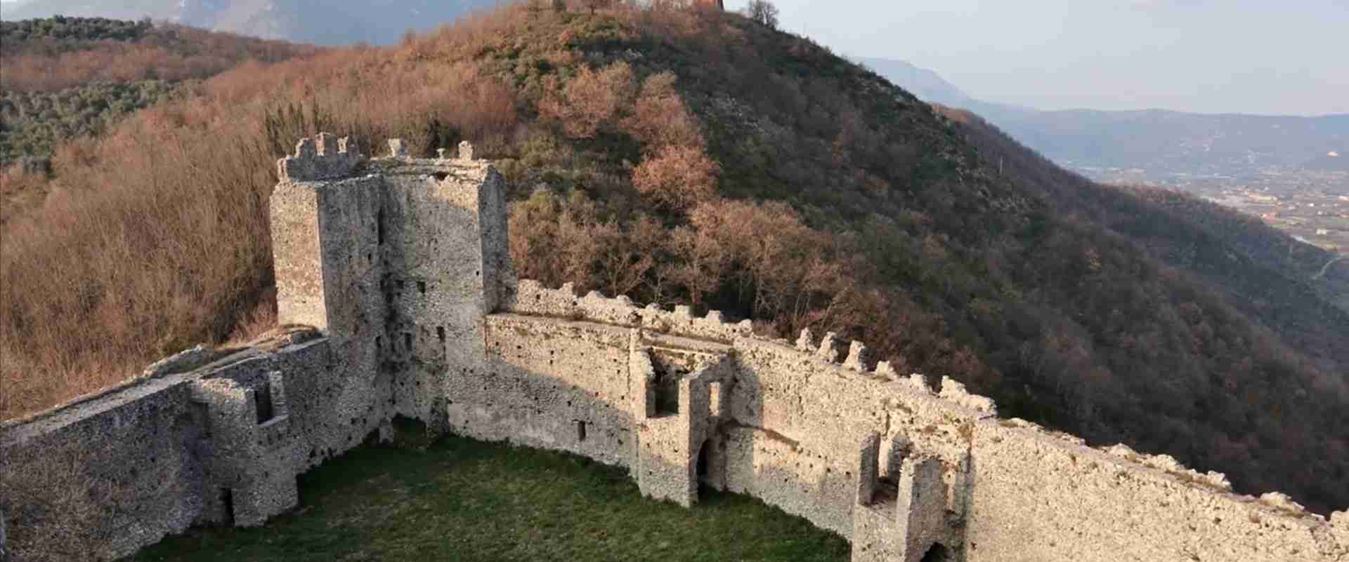
The Longobard Shield of Salerno: Engineering the Bastions of Castello di San Severino
Perched on a Picentine ridge spur above the convergence of the Sarno, Irno, and Irpinian valley routes, Sanseverino Castle—Castello di San Severino—preserves one of the most layered records of early medieval military engineering in southern Italy. From a Longobard first nucleus through successive Norman, Swabian, Angevin, and Aragonese phases, it expanded across three concentric ring walls covering roughly 157,500 square metres and incorporating an extraordinary system of cisterns distributed beneath every tower of its outer defensive circuit.
Key Takeaways
- Sanseverino Castle’s Longobard first nucleus is believed to date from the early Lombard occupation of the area from the mid-seventh century onward, when the site functioned as the gastaldato (Longobard administrative district) of Rota within the Duchy and later the Principality of Salerno—a role confirmed by the 949 diviso Ducatus document.
- Three concentric ring walls encircle the ridge spur, ascending from approximately 250 m to 365 m above sea level, creating a system of defence in depth organised as administrative acropolis, incastellato borough, and outer military perimeter.
- Grey volcanic tuff (tufo grigio campano), quarried from Campanian volcanic deposits, appears in the castle’s crenellated battlements and the corbelled crown of the circular keep—continuing a regional building tradition rooted in the Campanian Ignimbrite and pozzolanic masonry culture that extends from Roman antiquity through the medieval period.
- The third ring wall’s system of water storage is architecturally distinctive: the large circular keep has a cistern integrated into its lowest level, and each of the seven quadrangular towers along the southern curtain wall has a cistern beneath it—distributing the castle’s water reserve across the entire most-threatened perimeter rather than concentrating it in a single vulnerable point.
- Archaeological excavations conducted between 2001 and 2006 by the Centre for Medieval Archaeology at the University of Salerno documented metallurgical workshop remains, siege weapon evidence, numismatic material, and ceramics across a complex multi-phase stratigraphy, with results published by Professor Paolo Peduto in 2008.
- A convergent independent parallel exists between the spur-between-rivers topographic logic of Sanseverino Castle and Kangra Fort in the Himalayan foothills of Himachal Pradesh—two fortifications developed in entirely separate cultural traditions that arrived at broadly similar solutions to the engineering problem of hilltop garrison supply and water security.
People Also Ask About Castello di San Severino
What is the Longobard architectural legacy at Castello di San Severino?
The Longobard legacy at Sanseverino Castle is foundational rather than fully visible: the physical fabric of the fortress as it stands today is primarily Norman, Swabian, Angevin, and Aragonese in character, but it was built upon a Longobard first nucleus established when the site functioned as the gastaldato of Rota within the Principality of Salerno. The 949 diviso Ducatus, a document formally partitioning Lombard southern Italy, confirms that the gastaldato di Rota was administered within the Longobard principality, implying a permanent garrisoned presence on the ridge before the Norman takeover of 1077. Archaeological stratigraphy from the 2001–2006 University of Salerno excavations confirms a pre-Norman construction phase at the summit, though the precise character of the Longobard fortification has not been fully delineated by excavation. The Longobard contribution to the site is therefore structural in the deepest sense: the choice of the spur, the first circuit on the summit, and the administrative network of intervisible castella that Sanseverino Castle anchored are all expressions of Lombard military doctrine applied to the Picentine terrain.
How does volcanic tuff masonry perform in seismically active zones?
Campanian volcanic tuff (tufo campano) has been the subject of systematic structural engineering investigation, with particular reference to its seismic behaviour in the historically and geologically active region of southern Italy. Research at the Department of Structural Engineering of the University of Naples Federico II, drawing on a dataset of 635 double flat-jack tests conducted in existing tuff masonry buildings throughout Campania, has characterised the material’s elastic modulus and compressive performance across different construction types and historical periods. Single-leaf tuff masonry panels achieve a mean compressive strength of approximately 2.78 MPa, while multi-leaf rubble-core panels typical of fortification construction average approximately 1.83 MPa. Tuff masonry’s relatively low elastic modulus—reflecting the material’s porosity and moderate density—gives it a degree of deformation capacity before failure that provides some energy absorption under cyclic loading. Whether this constitutes deliberate seismic engineering on the part of medieval builders, or a structural consequence of a material choice made primarily for workability and availability, is a distinction that the evidence does not resolve: medieval builders selected tuff because it was locally accessible and easily dressed, not because they calculated its seismic response.
How were cisterns integrated into the defensive design of early medieval Italian hillforts?
Water supply under siege conditions was among the most critical limiting factors in the defence of any hilltop fortification: a garrison that could be cut off from water was more vulnerable than one that could be starved of food, because water shortage incapacitates troops far more rapidly. The response across Campanian and southern Italian medieval hillforts was the architectural integration of cisterns into the fabric of defensive towers and curtain walls—intercepting and storing rainwater from elevated collection surfaces before it could drain away down the hillside. The most developed expression of this logic at Sanseverino Castle is the distribution of cisterns beneath each of the seven quadrangular towers of the third ring wall’s southern curtain, supplemented by the large cistern integrated into the base of the circular keep. This arrangement distributed the water reserve across the entire most-exposed face of the perimeter, eliminating the vulnerability of a single central cistern to interdiction or contamination. The same principle of hydraulic integration appears, in different architectural form, in Kangra Fort’s two interior tanks and sacred stepwell—a convergent solution reached independently in the Himalayan military tradition.
What makes the three-enclosure layout of Sanseverino Castle architecturally significant?
The three-enclosure layout of Sanseverino Castle is significant both as a record of the incastellamento process—the transformation of dispersed Lombard-era administrative posts into nucleated fortified communities—and as a documentation of how military engineering adapted to changing tactical requirements over five centuries of continuous occupation. The first enclosure at the summit functions as a palatial acropolis, the second as a protected borough, and the third as a military perimeter; each phase reflects a different political and military context, from the Longobard gastaldato through the Norman feudal seat to the Angevin-Aragonese artillery fortification. The result is a rare example of a site where the full trajectory of early medieval to late medieval military architecture can be read in a single physical complex across a 350 by 450 metre footprint—Italy’s second-largest castle compound by area. The systematic documentation of this layered sequence by the University of Salerno’s archaeological programme has made the site a reference point for the study of multi-phase castle development in the Italian Mezzogiorno.
Extended multi-day tours – 5+ days
Featured Salerno Multi-Day Tour Packages

3 days
Salerno 3-Day Discovery Tour
- ✓ Comprehensive Salerno experience
- ✓ Expert local guides included
- ✓ All accommodation included
- ✓ Transportation provided
5 days
Salerno 5-Day Highlights Experience
- ✓ Comprehensive Salerno experience
- ✓ Expert local guides included
- ✓ All accommodation included
- ✓ Transportation provided
7 days
Salerno 7-Day Cultural Journey
- ✓ Comprehensive Salerno experience
- ✓ Expert local guides included
- ✓ All accommodation included
- ✓ Transportation provided
10 days
Salerno 10-Day Complete Adventure
- ✓ Comprehensive Salerno experience
- ✓ Expert local guides included
- ✓ All accommodation included
- ✓ Transportation provided
Multi-day tour packages powered by TourRadar. Prices and availability subject to change.
The Longobard Principality of Salerno and the Strategic Imperative
The Lombards arrived in Italy in 568 AD and within decades had established the Duchy of Benevento as the southernmost expression of their expansion, pressing against Byzantine coastal enclaves at Naples, Amalfi, and Salerno. The city of Salerno itself fell to Lombard forces under Arechi I of Benevento around 646 AD, transforming from a Byzantine-controlled port into the principal Lombard gateway to Campania’s coastal and mountain zones. The strategic geometry of Salerno’s position—commanding the northern shore of the Gulf of Salerno, flanked by the Picentine range to the north-east and the Sorrento peninsula to the north-west—made it both the natural capital of the southern Lombard world and a point of permanent military tension.
The definitive reorganisation of this region’s defences came in 774, when Arechi II, having escaped Charlemagne’s destruction of the Lombard kingdom at Pavia, moved his court from Benevento to Salerno and rebuilt the city’s fortifications. From this southern capital he implemented a comprehensive defensive restructuring of the territory, expanding the circuit walls of Salerno itself while simultaneously establishing or reinforcing a network of inland mountain positions designed to monitor and block the passes through the Picentine range. The Arechi Castle above Salerno—its origins traced to a Byzantine fortification of the sixth century—was extensively rebuilt during this period and became the principal symbol of Lombard authority over the region.
When the Duchy of Benevento divided in 851, the Principality of Salerno emerged as an independent Lombard state under the Dauferid dynasty. For more than two centuries, until the Norman advance under Robert Guiscard absorbed it in 1077, this principality maintained one of the most systematically organised defensive networks in southern Italy. Its castella were not isolated structures but coordinated nodes in a chain of visual communication and military response. Documentary and archaeological evidence—including recent work on the defensive structures of the media valle del Sele area of the Salernitan principality—confirms that the network operated on the principle of intervisibility: each garrison position could signal to adjacent nodes within minutes, mobilising a territorial response that no single castle could achieve alone.
The mountain spine of the Picentine range provided both a defensive barrier and a strategic liability. Its passes—particularly the approaches through the Valle dell’Irno and the upper Valle del Sarno—were the natural corridors for any army moving from the Campanian interior toward the Salerno coast. Control of the high ground above these corridors was essential to the principality’s survival against the persistent threats from Saracen raiders operating from Agropoli and other coastal strongholds, from Byzantine forces to the south-east, and later from the Norman advance from the north. The ridge spur at Rota—present-day Mercato San Severino—occupied the precise convergence point where the roads from Sarno, the Irno plain, and the Irpinian upland valleys met before descending toward Salerno, making it a position of exceptional strategic value within the Lombard defensive system.
The Gastaldato of Rota: Administrative Geography and the Mountain Frontier
The Lombard term gastaldato derives from the gastald, an official appointed by the prince to administer a defined territorial unit combining judicial, fiscal, and military functions. The gastaldati of the Principality of Salerno were the building blocks of its territorial organisation, ensuring that the mountain approaches were manned by resident populations with a direct obligation of military service to the prince. Unlike the purely extractive fortresses of some later medieval traditions, the Lombard gastaldati were administrative centres that managed agricultural production, controlled road access, levied taxes in kind, and marshalled local militias—combining the functions of what later centuries would separate into castle, market town, and rural parish.
The gastaldato of Rota is confirmed in the diviso Ducatus of 949, the document that formally partitioned the Lombard territory of southern Italy between the rival principalities of Salerno, Benevento, and Capua. Its assignment to Salerno in this document implies an already-established administrative presence at the site, since the diviso recognised existing territorial facts rather than creating new ones. Local chronicle traditions, reported by the humanist Pietro Summonte, record that the site’s strategic significance predated the Sanseverino family who would later give the castle and borough their name—suggesting a long history of fortified occupation on the spur that the subsequent Norman and Angevin phases obscure but did not originate.
The relationship between the gastaldato and the mountain road network was its primary military function. The ancient road axis between Capua and Reggio—one of the principal routes linking Campania to the south—passed through the area of Rota, and the confluence of the Solofrana and Calvagnola torrents at the foot of the ridge spur marked a natural road junction. Control of this junction meant control of the movement of armies, goods, and communications between the interior and the coast. The Lombard builders who first fortified the summit of the Collina del Parco at Rota were applying a principle documented across the entire medieval landscape of the Campanian interior: the ridge spur above the road junction commands the junction by virtue of its elevation, and whoever holds the spur holds the road.
The Lombard first nucleus at the summit of Collina del Parco has not been fully delineated by excavation. The archaeological investigations of 2001–2006 confirmed a pre-Norman construction phase at the summit through stratigraphic evidence, and the multiple sources describing the castle consistently identify a primo nucleo di costruzione longobarda (first nucleus of Lombard construction) preceding the Norman palatial compound. The specific character of this first nucleus—whether it comprised a simple circuit wall, a watchtower, or a more developed garrison structure—remains incompletely documented. What can be stated with confidence is that the Lombard administrative presence at Rota was substantial enough to generate a significant fortified node in the Principality of Salerno’s defensive network, and that when the Norman knight Turgisio Sanseverino received the fief of Rota from Duke Robert Guiscard after 1067, he was not building on virgin ground but adapting an existing Lombard military and administrative complex to Norman feudal organisation.
The broader landscape of the gastaldato extended well beyond the ridge spur itself. The surrounding territory controlled the agricultural production of the valley floor, the quarrying of building stone from the lower Picentine slopes, and the commercial traffic through the road junction. The castle’s later development as a significant market centre—the name Mercato San Severino preserves this mercantile function—reflects the longstanding importance of the site as a node of exchange as well as military control. The market and the castle were, in the Lombard administrative tradition, expressions of the same political authority: the gastald who taxed the traffic through the mountain pass and the lord who garrisoned the castle commanding it were performing complementary aspects of territorial sovereignty.
Fortified Ridge Topography: Curtain Walls, Cisterns, and Early Medieval Strategic Enclosures
The fundamental defensive decision at Rota was geographical before it was architectural. The ridge spur of the Collina del Parco rises from the valley floor at approximately 140 m above sea level to its summit plateau at roughly 365 m, with near-vertical scarps on its northern and western flanks provided by the natural erosion of the Solofrana and Calvagnola torrents cutting into the hillside. These natural cliffs reduce the constructed perimeter requiring active curtain wall defence to the eastern and southern approaches—the faces from which any ground-based assault would necessarily be mounted. The architectural investment of the castle builders was therefore concentrated precisely where the natural terrain offered least protection, while the cliff faces substituted for masonry wall over significant sections of the circuit at near-zero construction cost.
This principle of cliff integration—exploiting natural scarps to reduce the built perimeter and concentrate defensive investment in the most exposed sectors—is one of the defining characteristics of Lombard and Norman military architecture in the hill zones of the Italian south. The Lombard builders who established the first nucleus at Rota were working within a broader tradition of ridgetop fortification that understood the landscape itself as the primary defensive element, with masonry construction as its supplement rather than its replacement. The choice of a spur position above a valley junction, flanked by natural water barriers that also provided cistern catchment, reflects a systematic reading of terrain that subsequent centuries of military occupation confirmed as optimal.
The three concentric ring walls (cinte murarie) of Sanseverino Castle descend the slope in sequence, creating three distinct defensive zones with different architectural characters reflecting their different periods of construction and functions. The first enclosure occupies the summit plateau at approximately 365 m above sea level. It encloses the palatial precinct, the palatine chapel of Santa Maria de Castro with its funerary crypt, the parade ground, and the metallurgical workshop area revealed by the 2001–2006 excavations. In organisational terms, this upper enclosure functions as an acropolis—a self-contained administrative and ceremonial compound that could sustain independent resistance even if the outer ring walls were breached. Its walls are the oldest surviving masonry on the site and reflect the Norman period’s transformation of the Lombard administrative compound into a feudal palatial precinct.
The second enclosure extends the defended area down the slope to approximately 300 m, surrounding the borough structures that grew as the castle’s population expanded through the Norman and Swabian periods. The archaeological record within this zone documents more than one hundred distinct residential units along with communal facilities: cisterns, storage spaces, the remains of an oven, and the church of San Severino in Monte, construction of which is documented from the second half of the eleventh century. The density of habitation within the second enclosure is consistent with the incastellamento model of nucleated fortified settlement characteristic of the period: the ring wall did not enclose only a military garrison but an entire community of craftspeople, agriculturalists, ecclesiastics, and their dependants, all under the protective authority of the Sanseverino lordship.
The third and lowest enclosure, at approximately 250 m above sea level, is the most militarily specialised of the three circuits and bears the most visible marks of adaptive engineering across the castle’s history. Its character was most substantially defined in the Angevin and Aragonese periods, when the introduction of gunpowder artillery required a systematic reconfiguration of the defensive perimeter. The result is a triangular circuit wall whose vertex is defined by the large circular keep (torre a rondella, functioning as the main keep) and whose southern curtain is reinforced by seven quadrangular towers equally spaced along its length. This Angevin-Aragonese outer perimeter is the public face of the castle as it appears from the valley below—the most immediately legible expression of military authority in the landscape of the lower Picentine foothills.
The overall dimensions of the complex—approximately 350 by 450 metres, covering a total area of roughly 157,500 square metres, equivalent to three football pitches—place Sanseverino Castle among the largest medieval fortress compounds in the Italian peninsula. Only the castles of Fenis in the Aosta Valley and a handful of other exceptional sites approach this scale in the Italian context, and Sanseverino is commonly cited as Italy’s second-largest castle by area. This scale reflects the castle’s function as a fortified township rather than a purely military stronghold: the Sanseverino lordship, at its height one of the most powerful baronial dynasties in the Kingdom of Naples, required a seat commensurate with its political status and capable of housing not only a garrison but a court, an administrative apparatus, specialist workshops, a market infrastructure, and a civilian population.
Volcanic Tuff Masonry: Compression Strength and Seismic Resistance in Picentini Citadels
The Campanian volcanic tuff tradition represents one of the most distinctively regional building cultures in the Italian peninsula, shaped by the geological accident that made the Phlegraean Fields volcanic system—the Campi Flegrei—one of the most productive sources of consolidated pyroclastic material in Mediterranean Europe. The massive Campanian Ignimbrite eruption of approximately 39,000 years ago and the subsequent Neapolitan Yellow Tuff event of approximately 15,000 years ago blanketed large areas of Campania, Lazio, and the Tyrrhenian coastal zone with pyroclastic deposits that, once consolidated by zeolitic cementation and compaction, produced a stone that was both structurally serviceable and exceptionally easy to dress with iron tools. The result was a building culture in which volcanic tuff became the default material for dressed masonry from at least the Republican Roman period onward—used in everything from urban apartment blocks to aqueduct infrastructure and fortification walls.
Two primary varieties of Campanian volcanic tuff are distinguished by colour, density, and mechanical properties. The grey tuff (tufo grigio campano), derived from the older Campanian Ignimbrite deposits, is the denser and harder of the two: its higher silicification and lower residual porosity produce slightly higher compressive strength and better resistance to surface weathering than the more widely quarried Neapolitan yellow tuff (tufo giallo napoletano). In medieval Campanian fortification practice, the grey tuff was characteristically used for elements exposed to the most demanding environmental conditions—crenellations, corbels, and other projecting elements at the tops of walls—precisely because its greater density offered better long-term durability in positions exposed to rain and freeze-thaw cycling.
At Sanseverino Castle, grey tuff is confirmed in two specific and technically significant positions. The first is the crenellated battlements (merlatura) of the third ring wall’s curtain, where the merlons and the arrow-slit embrasures are dressed in grey tuff. The second is the corbelled crown (beccatelli in tufo grigio) of the circular keep, where a row of projecting tuff corbels supports the upper platform of the tower. In both positions, the choice of grey tuff over the more abundant yellow tuff reflects a considered judgement about material durability rather than a simple default: the corbel crown, projecting from the tower face and bearing both the weight of the platform above and the lateral thrust of any artillery recoil, requires a stone with adequate shear and bending resistance; the grey tuff’s greater density and lower porosity make it better suited to this role than the yellow variety.
The mechanical properties of Campanian tuff masonry have been characterised systematically through experimental programmes at the Department of Structural Engineering of the University of Naples Federico II. Compression tests on tuff masonry specimens, combined with flat-jack in-situ measurements in existing buildings throughout the Campania region, have established that single-leaf tuff masonry panels achieve a mean compressive strength of approximately 2.78 MPa, while multi-leaf panels—the construction type characteristic of medieval fortification curtain walls—average approximately 1.83 MPa. These values confirm that Campanian tuff masonry provides adequate compression resistance for the section thicknesses used in curtain wall and tower construction, with the caveat that the standard deviation of both datasets is significant, reflecting the variability in block quality, mortar composition, and construction period across a broad population of historic buildings.
For structural stability under gravity loading, the dominant condition for a free-standing curtain wall, the primary concern is that compressive stress at any section should not exceed the masonry’s compressive capacity, accounting for any eccentricity introduced by wind loading or the differential settlement of foundations on steep hillside terrain. The thick-walled rubble-core construction of medieval Campanian fortifications typically maintains compressive stresses well within the capacity of even low-quality tuff masonry, by using section depths—wall thicknesses of 1.5 to 2.5 metres at the base—that keep stresses at structurally conservative levels. The dressed tuff facing blocks, by keying their irregular rear faces into the mortar of the rubble core, contribute to the consolidation of the composite wall section.
The seismic behaviour of Campanian tuff masonry structures is a question of considerable engineering interest, given the region’s geological position in the seismically active Apennine zone. A systematic dataset of 635 double flat-jack tests in Campanian tuff masonry buildings has been used to calibrate the relationship between elastic modulus, compressive strength, and structural vulnerability under seismic loading—providing an empirical basis for the assessment of historic tuff buildings in the region. Tuff masonry’s relatively low elastic modulus, a consequence of the material’s porosity and grain-scale compressibility, gives it a degree of deformation capacity before failure that provides some energy absorption capacity under cyclic ground motion. This property is not unique to tuff—it is shared, in varying degrees, by all porous stone masonry types—but it is more pronounced in Campanian tuff than in the denser limestone or granite masonry of other Italian regions.
What distinguishes Sanseverino Castle’s masonry context is its proximity to a documented major seismic event. The catastrophic Campania–Basento earthquake of November 1980 (Mw 6.9) caused widespread structural destruction across the province of Salerno, devastating numerous hilltop villages and rendering many historic structures uninhabitable. Documentary sources for the historic centre of Mercato San Severino note that the town’s monuments were preserved relatively intact by this event compared with many surrounding areas—an observation that, while not constituting a formal post-earthquake structural assessment of the castle specifically, is consistent with the general performance of thick rubble-core masonry structures in the region under this intensity of ground shaking. Whether the castle’s survival reflects the mass and section depth of its walls, a favourable local ground condition at the ridge-top site, or simple statistical fortune within a complex pattern of damage, the available record does not establish with sufficient precision to support a claim of designed seismic performance.
The stone-dressing practices for grey tuff in medieval Campanian fortifications were straightforward by the standards of the period. Tuff blocks could be sawn or chiselled with iron tools without the heavy percussion work required for granite or hard limestone, and the material’s surface porosity allowed mortar to key into the dressed faces effectively, improving bond strength at the interface between facing block and core. The characteristic grey colour of the tufo grigio campano blocks at Sanseverino distinguishes them visually from the more common yellow variety in the broader regional landscape; for the visitor approaching the third ring wall from below, the grey tuff corbels of the circular keep crown and the matching merlons of the curtain provide a chromatic marker that identifies the Angevin-Aragonese phase of construction at a glance. This visual distinction between building phases—grey tuff for the military-engineering programme of the thirteenth through fifteenth centuries, limestone rubble for earlier and cruder construction—is a recurring feature of Campanian fortification sites where multiple periods of building remain legible in the same fabric.
The Three Concentric Enclosures: An Architectural Analysis
The analytical vocabulary appropriate to Sanseverino Castle’s three-enclosure layout draws on the broader typology of the incastellamento—the process of nucleated settlement fortification that, across the Italian peninsula from the ninth to eleventh centuries, transformed dispersed rural populations into defensible communities clustered around a lord’s stronghold. At Rota, this process was already underway in the Lombard period, given the administrative function of the gastaldato, and the castle’s three circuits document successive expansions of the defended perimeter rather than a single planned construction event. Each ring wall is the product of a distinct political moment: the Lombard and Norman administrative compound, the developed Norman and Swabian feudal borough, and the Angevin and Aragonese military perimeter—together constituting a palimpsest of five centuries of defensive building decisions.
The first enclosure preserves the core of the Lombard-Norman administrative compound and its Swabian successor. The palatial precinct contains the main residence hall—a tall rectangular structure documented in the survey literature as retaining two floor levels evidenced by corbel courses on the interior walls and double chimney flues in two corner positions. The adjacent palatine chapel of Santa Maria de Castro follows a standard Romanesque scheme: a single-nave vaulted plan measuring approximately 7 by 14 metres with a semicircular apse and an underlying funerary crypt. The crypt served as the burial place of the Sanseverino lords until the mid-fourteenth century, when the Franciscan convent at the foot of the hill redirected funerary arrangements outside the fortress perimeter. A significant episode associated with the first enclosure’s chapel is the visit of St. Thomas Aquinas, who came to Sanseverino to see his sister Teodora, married to a Sanseverino lord; historical sources including early biographies of Thomas and the study by Portanova (published 1924) record that he received what was regarded as a mystical vision in the castle’s chapel before departing on his final journey to France.
The stratigraphy of the first enclosure’s construction is the most complex on the site, since it is here that the evidence of Lombard, Norman, and Swabian building activity is superimposed most densely. The parade ground (piazza d’armi) that occupies the northern zone of this enclosure, at approximately 350 m above sea level, is identified as the oldest component of the visible plan—a designation consistent with the parade ground’s function as the organisational centre of any garrison compound, present from the earliest phase of military occupation. The metallurgical workshops documented immediately adjacent to the palatial precinct add a dimension of productive specialisation: the castle was not only a residence and garrison point but a manufacturing centre producing and maintaining the weapons and equipment of the Sanseverino military establishment.
The second enclosure, extending down the slope from the palatial precinct, houses what is effectively a small fortified town. The more than one hundred residential units recorded within it, along with the communal cisterns, storage facilities, oven remains, and churches, document the full spectrum of incastellato settlement life: families directly dependent on the lord’s protection, contributing to the castle’s economy through craft production and agricultural labour while benefiting from the collective security of the ring wall. The church of San Severino in Monte, whose construction is documented from the second half of the eleventh century, occupied a position at the heart of this borough community, providing the liturgical centre for a resident lay population as well as a symbolic expression of the Sanseverino lordship’s integration of sacred and secular authority.
The third enclosure represents the most intensively engineered military architecture on the site and the most visible component from the valley below. The circular keep at its vertex is a truncated conical structure of notable architectural sophistication: it rises on three levels, with a cistern occupying the lowest conical level (accessible from a square trapdoor in the floor above), a middle level providing four splayed embrasures for firearms defence, and an upper level supporting the crenellated crown of grey tuff corbels. The tower’s mean internal diameter of 4.6 metres and its three-level organisation compress a water storage function, a weapons platform, and a command position into a single architectural volume—an economy of construction that reflects the Angevin military engineers’ systematic approach to maximising defensive capability within the constraints of a limited construction programme.
The seven quadrangular towers of the southern curtain wall replicate this logic of stacked functions at smaller scale. Each tower has a cistern beneath it—a construction detail documented in the castle survey literature—combined with splayed embrasures (fori strombati) for small-arms fire from both the tower body and the cistern chamber. The gateway through this southern curtain is framed by a pointed arch on two pilaster responds set into the battered base of the wall, a detail that places its construction firmly in the Angevin architectural vocabulary of the thirteenth and fourteenth centuries. A later closure of this gateway—probably executed when the approach needed reinforcement against artillery—has sealed the arch behind later masonry, preserving its form as a stranded architectural element within the subsequent wall thickness.
Defensive Water Management: Cisterns as Military Infrastructure
Water supply under siege was the most acute limiting factor in the defence of any hilltop fortification. A garrison cut off from its water source would be incapacitated far more rapidly than one starved of food; historical sieges of major castles across Europe regularly turned on the question of access to cisterns, wells, or springs within the defended perimeter. The builders of Sanseverino Castle addressed this constraint with a solution that is architecturally distinctive even within the rich context of southern Italian medieval hydraulic engineering: the systematic integration of water storage capacity into the base of every tower along the most vulnerable face of the outer ring wall.
The hydraulic logic of this arrangement operates on a single principle: precipitation falling on the elevated surfaces of the wall-walk, the tower roofs, and the courtyard paving within the third ring wall is captured and drained into sealed masonry cisterns at the base of each tower, rather than allowed to run off down the hillside. The advantage of distributed rather than centralised water storage is primarily tactical: a single large central cistern can be interdicted, contaminated, or destroyed by a well-aimed projectile; eight cisterns distributed across the full length of the southern curtain wall present a much more resilient target set. A besieging force that succeeded in destroying one or two cisterns would still face a garrison with six or seven intact reserves.
The cistern beneath the circular keep is the most substantial individual element of this system. Occupying the full basal volume of the tower’s truncated-conical lower section, it stores a meaningful quantity of water for a garrison of the keep itself, accessible from the level above through a square trapdoor. This vertical integration of storage and combat function—effectively stacking a cistern beneath a gun emplacement—compresses two essential defensive requirements into a single architectural component, reducing the footprint of the water supply infrastructure while maintaining the tower’s full military utility at the levels above.
The cisterns of the seven quadrangular towers are individually smaller but collectively significant. Their distribution along the full length of the southern curtain means that any section of the wall-walk garrison has access to water within a short horizontal traverse, without the vulnerability of exposure in crossing open ground to a central cistern. The provision of embrasures for small-arms fire from within the cistern chambers adds a further operational layer to the tower base: even when the cistern is occupied for water collection, the chamber can function as a firing position, requiring no interruption to the defensive use of the structure.
The second enclosure preserves cisterns of a different architectural character: open-topped or lightly covered masonry-lined tanks associated with the communal facilities of the incastellato borough rather than with military provisioning. These are domestic water infrastructure serving the resident population’s daily needs, capturing rooftop drainage from the dense residential fabric of the borough and providing distribution points within a walking distance appropriate for a settled community. The coexistence of military cisterns in the third ring wall and domestic cisterns in the second reflects the dual nature of the castle as both a fortified community and a military installation—two water supply regimes serving different users under different conditions of urgency.
The overall water engineering of Sanseverino Castle is consistent with what archaeological and historical research has documented across other major Campanian and south Italian fortifications of the Norman and Angevin periods. The Hohenstaufen and Angevin courts of the Kingdom of Sicily invested substantially in hydraulic infrastructure across their castle network, and the distribution of cistern capacity across the outer ring wall at Sanseverino is most readily understood as an expression of this broader military hydraulic programme—though the specific engineering decision to integrate a cistern beneath each tower is sufficiently unusual in the regional inventory to be distinctive of the site.
Pozzolanic Mortars and the Campanian Building Tradition
The mortar technology of Campanian medieval fortifications belongs to one of the most historically significant building traditions in the Italian peninsula—a tradition of hydraulic binder use rooted in the geological character of the Phlegraean Fields volcanic system and transmitted, in modified form, through the centuries of medieval construction that separated the Roman engineering peak from the early modern revival of hydraulic lime technology. The Romans had developed pozzolanic mortar—lime combined with volcanic ash from Puteoli (modern Pozzuoli) or the Phlegraean Fields—into a construction material of remarkable performance, capable of setting in wet conditions and achieving the compressive strength required for subterranean and hydraulic construction. The term pozzolana is itself derived from Pozzuoli, a marker of the degree to which this Campanian material dominated Roman hydraulic building technology.
During the early medieval period, the theoretical understanding of pozzolanic chemistry was partially lost across Europe, and most medieval mortars reverted to purely aerial lime binders—mixtures of slaked lime, sand, and water that set by carbonation of the calcium hydroxide component rather than by hydraulic reaction. Archaeological mortar analysis across Italian sites dating from the early medieval through the early modern period consistently confirms this aerial lime predominance. However, in Campania specifically, the continuing abundance of volcanic ash and tuff dust from Phlegraean Fields and Vesuvian deposits meant that builders working with locally sourced aggregates would inevitably incorporate pozzolanic material into their mortar mixes, whether or not they understood the chemistry behind its enhanced performance. The aggregate drawn from local volcanic soils would carry sufficient reactive silica and alumina to initiate pozzolanic reactions in the lime binder, producing a mortar with at least partial hydraulic properties even when this was not the deliberate intention.
The documented analysis of medieval Campanian mortars from contexts in the broader region—including work on the medieval military shipyard at Amalfi—has demonstrated that builders in the Salerno cultural sphere actively modified their mortar compositions in response to performance requirements, with the identification of saccharide-based organic additives (natural plant gums) used to improve cohesion and resistance to tensile stress. These findings suggest a tradition of mortar technology that was not merely inherited from Roman practice but actively maintained and adapted by medieval craftspeople with practical knowledge of what worked in the local humid coastal and mountain environments.
For the mortars of Sanseverino Castle specifically, no published chemical analysis of sampled mortar from the castle fabric has appeared in the scholarly literature reviewed for this article—a distinction that is important to hold precisely, since the University of Salerno’s archaeological investigations of 2001–2006 were directed primarily at stratigraphic phasing, artefact recovery, and architectural documentation rather than materials characterisation. What can be stated with confidence is that the mortar visible in the surviving wall sections is consistent with the lime-based mortar tradition of other Campanian fortifications of comparable period, and that the Picentine location—within reach of Phlegraean Fields volcanic aggregate sources via the network of Roman and medieval roads connecting Salerno to Campanian quarrying zones—would have made pozzolanic material available to any builder prepared to source it.
The practical engineering consequence of mortar quality in a rubble-core fortification wall is significant. In a typical medieval curtain wall built with dressed stone facing on both faces and a core of mortared rubble and smaller stones, the mortar’s hydraulic character determines the core’s long-term resistance to moisture penetration, differential movement, and gradual disaggregation. A hydraulic mortar that consolidates the core into a near-monolithic mass resists the progressive loosening of the rubble fill that, over centuries, can reduce a curtain wall from a structural element to a pile of loose stone held in place only by its facing. The grey tuff facing blocks of the Sanseverino circuit, with their irregular rear faces keying into the core mortar, contribute to this consolidation—the porous tuff surface providing both a mechanical interlock and a moisture-exchange interface that distributes and moderates the differential wetting and drying cycles that are a primary cause of mortar degradation in exposed fortification walls.
The Cross-Cultural Parallel: Himalayan Hillfort Engineering at Kangra Fort
The convergent emergence of similar defensive engineering solutions across cultures with no historical contact is among the most revealing phenomena in the comparative study of medieval military architecture. Sanseverino Castle in the Campanian Picentine foothills and Kangra Fort in the Dhauladhar foothills of Himachal Pradesh developed within entirely independent political and cultural traditions—the Lombard-Norman Kingdom of southern Italy and the Katoch Rajput dynasty of the western Himalayan hill states—separated by roughly seven thousand kilometres and by the full depth of the medieval Eurasian world. Yet the structural logic underlying both complexes reflects the same set of environmental constraints and strategic requirements, producing configurations that, viewed at the level of defensive principle, are strikingly cognate. The comparison is offered here as convergent independent development, not as any implied genealogical connection or transfer of knowledge.
Site selection: the spur-between-rivers pattern. Sanseverino Castle occupies the Collina del Parco spur flanked on its lower slopes by the torrenti Solofrana and Calvagnola converging toward the Valle dell’Irno. Kangra Fort, the largest fortress in the Indian Himalayas, stands on a hillock at the confluence of the Banganga and Manjhi rivers in Kangra district, Himachal Pradesh. In both cases, the watercourses serve a dual defensive function: they provide natural moat sectors across the lower approaches that would otherwise require constructed walls, and they supply the water sources—surface flow and precipitation catchment—for the hydraulic infrastructure integrated into the fortification. The spur position between converging watercourses is a universal answer to the same military geometry: it maximises the defensive height advantage while minimising the constructed perimeter that must be actively defended.
Cliff integration and constructed perimeter reduction. At Kangra, the earliest sections of the fort attributed to the Katoch dynasty use dry stone masonry: massive irregularly shaped stones fitted without mortar, with deliberately sloping outer faces designed to deflect projectiles and resist battering. The hillock’s natural drops to the river channels below reduce the required wall height on the river-facing flanks, with the sheer slopes substituting for curtain wall over significant sections of the circuit—exactly as the natural scarps of the Collina del Parco reduce the constructed perimeter at Sanseverino on its northern and western faces. Both builders concentrated their masonry investment in the approach sectors where natural protection was absent, leaving the natural terrain to perform the defensive function where it was adequate.
Water storage and the cistern system. The Mughal-period writer Shah Nawaz Khan, in his Ma’asir-al-Umara, recorded that Kangra Fort contained two large tanks within its inner circuit; the fort also preserves the Kapoorsagar, a sacred stepwell integrated into the fortification’s interior. Together, these water storage elements provided the garrison with a supply independent of external springs or rivers—a necessity for sustained occupation under siege. At Sanseverino, the distributed cistern system beneath the seven quadrangular towers of the third ring wall and the large cistern beneath the circular keep represent a more architecturally elaborate solution to the same problem: rather than two centralised tanks, the Campanian builders distributed storage capacity across the entire southern defensive perimeter, eliminating the single-point vulnerability of centralised storage while accepting the additional construction cost of multiple cistern chambers. Both solutions reflect the same strategic priority—that a garrison without water is a garrison that will surrender—reached through engineering means appropriate to their respective construction cultures.
Masonry materials adapted to local geology. The material cultures of the two fortifications reflect their geological settings rather than any difference in engineering intent. Sanseverino Castle draws on the Campanian volcanic tuff tradition—a porous, easily dressed pyroclastic stone with moderate compressive strength and a natural affinity for hydraulic lime mortars enriched with Phlegraean Fields pozzolanic aggregate. Kangra Fort, in the oldest sections attributed to the Katoch dynasty, uses local stone—quartzite and conglomerate from the Himalayan frontal zone—in a dry masonry technique that substitutes friction and mass for mortar bond. The oldest Kangra walls have sloping outer faces of massive irregularly shaped blocks fitted with precision, producing a structure whose stability derives from the interlocking geometry of the stone assembly rather than the tensile capacity of a mortar matrix. The two material strategies are genuinely different responses to genuinely different geological conditions, not different expressions of the same knowledge.
Seismic exposure and structural outcome. Both sites lie in seismically active zones, and both fortifications carry the physical traces of earthquake history—though with strikingly different outcomes. Kangra Fort is classified within India’s Seismic Zone V, the highest risk category, situated directly above the Himalayan frontal thrust system where the Indian subcontinent continues to drive beneath the Eurasian plate. The Kangra earthquake of 4 April 1905 struck the valley with devastating force, collapsing large sections of the fort’s walls and towers and leaving the complex in the partially ruinous condition it occupies today. The Kangra site’s lithology of fractured quartzites and conglomerates may amplify ground shaking through resonance effects, compounding the hazard of the high-hazard tectonic setting. Sanseverino Castle, in the seismically active Campanian zone, experienced the proximity of the 1980 Campania earthquake (Mw 6.9), and documentary sources for the Mercato San Severino historic centre note that the town’s monuments survived this event in relatively intact condition compared with many other structures in the affected province. The material explanation for this contrast is not established in the detail required for causal certainty, but the combination of thicker rubble-core walls with hydraulic mortar binding at Sanseverino, versus the dry masonry construction of Kangra’s oldest sections, is consistent with the observed difference in earthquake survival.
Convergence and divergence: what the parallel reveals. The Sanseverino-Kangra comparison demonstrates that the combination of spur-between-rivers site selection, natural cliff integration, multi-enclosure defensive organisation, and hydraulic infrastructure integrated into the defensive fabric represents something close to a universal engineering optimum for pre-industrial hilltop fortification. Both complexes arrived at broadly similar configurations through entirely independent processes of military experience, adaptive construction, and response to the specific geological and climatic conditions of their respective settings. The differences between them—in material, in seismic resilience, in the spatial organisation of water storage—reflect the local conditions rather than any difference in underlying strategic logic. The comparison is thus instructive in both directions: it confirms the universality of the tactical principles involved, and it illustrates the material specificity with which those principles were implemented when the builders were working with what their own landscape provided.
Archaeological Investigations and Material Evidence
The systematic archaeological investigation of Sanseverino Castle began in 1985, when initial excavation work documented the first stratigraphic sequences on the site and established the basis for a more comprehensive research programme. The major investigation that defined the current scholarly understanding of the castle’s phasing was conducted between 2001 and 2006 by the Centre for Medieval Archaeology at the University of Salerno, under the direction of Professor Paolo Peduto. This programme produced a substantial body of stratigraphic, architectural, and artefactual evidence published in the volume Mercato San Severino nel Medioevo: il castello e il suo territorio, edited by Peduto and published in Florence by All’Insegna del Giglio in 2008—the primary scholarly reference for the site and the foundation of most subsequent interpretative work.
The excavations confirmed a multi-period construction sequence spanning from the pre-Norman occupation through the Lombard, Norman, Swabian, Angevin, and Aragonese phases, each identifiable through a combination of architectural fabric, stratigraphic position, and associated artefact assemblages. The stratigraphic complexity of the first enclosure—where successive building phases are superimposed on the most densely occupied part of the ridge spur—presented particular challenges for phasing, since later construction frequently incorporated or destroyed evidence of earlier activity. The identification of the Lombard first nucleus is based on pre-Norman stratigraphic evidence from this zone, consistent with the documentary record of the site’s early medieval administrative function, though the precise built form of this earliest phase has not been fully recovered.
Among the most significant discoveries of the excavation programme were the metallurgical workshop remains within the first enclosure: slag deposits, tool fragments, and the structural evidence of furnaces appropriate to metalworking at a scale consistent with weapons and military equipment manufacture. This evidence of in-castle productive specialisation documents the Sanseverino lordship’s logistical self-sufficiency in military supply—an important indication that the castle was not merely a residence and garrison point but an integrated military-economic complex capable of maintaining and repairing its own weapons inventory without dependence on external supply chains.
The evidence for siege weapon systems—catapult and mangonel mechanisms—recovered from the excavations adds a further operational dimension to the castle’s military history. The presence of these weapon systems within the enclosed precinct is consistent with the historical record of the Sanseverino family’s military campaigns across the Kingdom of Naples, and with the castle’s function as a major feudal seat from which military expeditions were mounted as well as resisted.
The numismatic assemblage from the excavations has been studied as a body of evidence for monetary circulation in medieval Campania, with a corpus of coins spanning from the late medieval through the early modern periods documenting the integration of the castle community into the commercial networks of the wider region. The ceramic assemblages provide the principal dating evidence for individual stratigraphic contexts and have been used to calibrate the relative phasing of structures across the site. Arrow tips and other military hardware complete the material picture of a castle that was an active military installation rather than a purely residential or administrative complex.
Since 2018, a selection of the excavated artefacts has been accessible to visitors at the Ministruttura Museale (MIMU) of the castle park—a small but focused display that provides public access to the material results of the University of Salerno programme and situates the artefacts within their architectural and historical context. The castle complex is administered as the Regional Natural and Archaeological Park of the Sanseverino Castle, providing a management framework that integrates heritage conservation, archaeological research, and visitor access within a single institutional structure.
Conservation, Heritage Status, and Visitor Access
Sanseverino Castle occupies an important but challenged position in the Italian heritage landscape. As the second-largest castle compound in Italy by area, it holds a place in the national inventory of military architecture that few other sites can match in terms of spatial extent and chronological depth. The FAI—the Fondo Ambiente Italiano, Italy’s principal private heritage conservation organisation—has listed the site among its luoghi del cuore, the annually compiled register of beloved but underfunded heritage places, a recognition that reflects both the site’s architectural significance and the scale of the conservation challenges it faces.
The primary conservation challenge is vegetation management across a hillside site covering more than fifteen hectares of masonry surfaces. Without continuous intervention, plant growth penetrates mortar joints, roots displace stone faces, and the biological crust of moss and lichen accelerates surface erosion. The Regional Natural and Archaeological Park status provides an institutional framework for managing these pressures, but the resources routinely available for an active conservation programme at a local authority scale are not proportionate to the task posed by a 157,500-square-metre fortification complex.
The seismic performance of the castle’s masonry in the 1980 Campania earthquake, noted in the documentary record for the historic centre of Mercato San Severino, offers some reassurance about the structural integrity of the surviving ring walls, but seismic events impose cumulative micro-fracturing in mortar joints even when walls do not collapse, and the mortar fabric of an eight-centuries-old fortification in a humid sub-Apennine climate accumulates water infiltration damage that accelerates after each major ground motion event. Conservation interventions have focused particularly on the most vulnerable sections of the third enclosure, around the circular keep and its adjacent gateway, where the Angevin-period masonry is most exposed and where any loss of structural integrity would compromise the most architecturally distinctive component of the site.
The castle is accessible to visitors as the Regional Natural and Archaeological Park of the Sanseverino Castle. Guided tours are offered by local operators including the Universitas Sancti Severini association, with guides meeting visitors at the park parking area at the foot of the Collina del Parco. Two tour routes are available: a tourist route of approximately 3 km accessible to all visitors, and a more demanding hiking route through the surrounding park terrain that requires basic fitness and appropriate footwear. The MIMU at the base of the hill provides contextual displays for the excavation findings. Annual heritage events—including a medieval re-enactment festival held in September—complement the regular guided tour programme.
For current opening times, tour booking arrangements, ticket pricing, and any seasonal access restrictions reflecting ongoing conservation or excavation work, visitors should consult the official castle website (castellomedievaledeisanseverino.it) directly, the comune di Mercato San Severino, or the Scabec regional heritage agency. These details are subject to seasonal variation and are affected by the scheduling of ongoing archaeological and conservation activities on the site.
Frequently Asked Questions
Who built Castello di San Severino and when?
The castle complex developed in multiple phases over several centuries. A Lombard first nucleus on the ridge spur is believed to date from the period of Lombard occupation of the area from around 640 AD onward, when the site functioned as the gastaldato of Rota within the Duchy and later the Principality of Salerno. The formal establishment of the castle as a Norman feudal seat dates from after 1067, when the knight Turgisio Sanseverino received the fief of Rota from Duke Robert Guiscard and developed the palatial precinct and first ring wall in their Norman form. Subsequent Swabian, Angevin, and Aragonese modifications expanded the lower ring walls and towers through the fifteenth century, producing the three-enclosure complex visible today.
What is a gastaldato and what was its role at this site?
A gastaldato was the basic territorial-administrative unit of the Lombard principalities, headed by a gastald—a royal appointee responsible for taxation, military levying, and judicial functions within a defined territory. The gastaldato of Rota is confirmed in the diviso Ducatus of 949, a document partitioning Lombard southern Italy that formally assigned Rota to the Principality of Salerno. The gastald of Rota controlled the mountain road network through the adjacent Picentine passes and garrisoned the ridge position above the valley junction—a combination of administrative and military functions that made the post a strategically significant appointment within the principality’s defensive system.
What are the three ring walls and what does each one contain?
The three concentric ring walls of Sanseverino Castle represent three distinct defensive zones and historical phases. The first ring at approximately 365 m above sea level encloses the administrative-palatial core: the lord’s residence hall, the palatine chapel of Santa Maria de Castro with its funerary crypt, the parade ground, and the metallurgical workshops. The second ring at approximately 300 m incorporates the fortified borough—over one hundred residential units, communal cisterns, storage facilities, and the church of San Severino in Monte. The third ring at approximately 250 m is the purely military outer perimeter, incorporating the circular keep with its integrated cistern and the seven quadrangular towers each with cisterns beneath, producing a system of defence in depth requiring an attacker to overcome three successive barriers before reaching the inner compound.
Where does the grey volcanic tuff at Sanseverino Castle come from?
The grey volcanic tuff (tufo grigio campano) used in the castle’s crenellated battlements and tower corbels derives from the Campanian Ignimbrite volcanic deposits of the Phlegraean Fields (Campi Flegrei) system north-west of Naples. These deposits, product of a major eruption approximately 39,000 years ago, blanketed large areas of Campania with consolidated pyroclastic material that became one of the region’s primary construction stones from antiquity onward. The grey tuff is denser and harder than the more common Neapolitan yellow tuff from a later eruption, making it better suited to exposed elements at the tops of walls—precisely the positions where it appears at Sanseverino, in the merlons of the battlements and the corbelled crown of the circular keep.
What did the University of Salerno excavations find?
The excavations conducted between 2001 and 2006 by the Centre for Medieval Archaeology at the University of Salerno documented a complex multi-phase stratigraphy confirming Lombard, Norman, Swabian, Angevin, and Aragonese occupation. The most significant discoveries included metallurgical workshop remains within the first enclosure—slag, tool fragments, and furnace structures indicating weapons manufacturing—alongside evidence of siege weapon systems (catapult and mangonel mechanisms), coins, ceramics, and domestic finds documenting the material life of the castle community across multiple centuries. The results are published in Paolo Peduto (ed.), Mercato San Severino nel Medioevo: il castello e il suo territorio (Florence: All’Insegna del Giglio, 2008), the primary scholarly reference for the site.
Did St. Thomas Aquinas really visit Sanseverino Castle?
Historical sources confirm that St. Thomas Aquinas visited Sanseverino Castle to meet his sister Teodora, who was married to a member of the Sanseverino family. Multiple documentary sources, beginning with early biographies of Thomas and including the dedicated historical study by Portanova (Il Castello di S. Severino nel XIII secolo e S. Tommaso d’Aquino, Badia di Cava, 1924), record that Thomas received what his contemporaries regarded as a mystical vision in the castle’s palatine chapel during this visit, before departing on his final journey toward France as a papal ambassador and dying en route. The chapel of Santa Maria de Castro within the first enclosure is identified in the documentary and topographic tradition as the location of this episode.
How does the cross-cultural comparison with Kangra Fort work?
Kangra Fort in Himachal Pradesh, India—the largest fort in the Indian Himalayas—shares with Sanseverino Castle a set of structural principles that emerged independently in two entirely separate cultural and historical traditions. Both forts occupy spur positions between converging watercourses, exploit natural cliff faces to reduce the constructed defensive perimeter, organise their defences in multiple concentric enclosures, and integrate water storage directly into their defensive fabric. The comparison is one of convergent independent development: both building traditions arrived at broadly similar configurations by reasoning from the same military geometry under different geological and cultural conditions, not through any transfer of knowledge or historical contact. The material differences—volcanic tuff and hydraulic mortar in Campania versus local dry stone masonry in the Himalayan foothills—reflect the local geology rather than any difference in underlying strategic logic.
Why is Sanseverino Castle considered Italy’s second-largest castle?
The Sanseverino Castle complex covers a total area of approximately 157,500 square metres—about 350 metres by 450 metres across its three ring walls—placing it second in Italy by extent of enclosed area, behind only a small number of exceptional castle compounds. This scale reflects the castle’s function as a fortified township as much as a military stronghold: the Sanseverino lordship, at its medieval peak one of the most powerful baronial dynasties in the Kingdom of Naples, maintained a court, a civilian population, specialist workshops, ecclesiastical buildings, and administrative facilities within the ring walls. The comparison of scale with purely military castles is therefore somewhat misleading; the Sanseverino complex is better understood as a fortified urban settlement of the incastellamento type, whose area includes residential, productive, and ceremonial zones as well as the purely defensive circuits.
How was the castle abandoned?
The castle’s abandonment was a direct consequence of political crisis. The Sanseverino family’s participation in the conspiracy of the Neapolitan barons against King Ferrante I of Naples in the late fifteenth century led to the confiscation of their feudal holdings when the conspiracy was suppressed. Although the castle passed through subsequent owners—including Ferrante Gonzaga after 1556—the loss of its function as the seat of a major dynastic power effectively ended its operational military and residential life. Without the resources of a great baronial family to maintain it, the complex was progressively abandoned through the sixteenth and seventeenth centuries, and the vegetation colonisation of its masonry that characterises the site today reflects three centuries of unoccupied exposure to the sub-Apennine climate.
What is the best way to visit Sanseverino Castle today?
The castle is open as the Regional Natural and Archaeological Park of the Sanseverino Castle, with guided tours available along two routes from the Universitas Sancti Severini parking area at the base of the Collina del Parco. The tourist route of approximately 3 km is accessible to all visitors and covers the principal architectural elements of the three ring walls, the circular keep, and the remains of the palatial precinct. The hiking route through the wider park terrain requires basic fitness and sturdy footwear. The MIMU (Ministruttura Museale) near the entrance provides displays of excavated artefacts for contextual orientation. Current tour availability, opening times, and seasonal schedules should be confirmed directly with the official castle website (castellomedievaledeisanseverino.it) or the municipality of Mercato San Severino, as these details vary seasonally and in response to ongoing conservation and excavation activities.