Yosemite National Park Geological Formations Guide
This comprehensive guide explores the natural architecture of Yosemite, examining the forces that shaped iconic features like El Capitan, Half Dome, and Yosemite Falls. Understanding these geological masterpieces reveals not just aesthetic beauty but the deep time processes that continue sculpting the Sierra Nevada.
Key Takeaways
- El Capitan rises 3,000 feet from the valley floor as one of the world’s largest exposed granite monoliths, formed from a single pluton cooled deep underground
- Half Dome’s distinctive shape results from exfoliation and glacial carving, not from splitting a complete sphere as popular myth suggests
- Yosemite Falls drops 2,425 feet in three sections, making it North America’s tallest waterfall and a prime example of hanging valley formation
- Cathedral Rocks and Three Brothers demonstrate how joint patterns in granite control erosion and create distinctive spires and buttresses
- Tuolumne Meadows represents the largest subalpine meadow in the Sierra Nevada, formed by glacial deposits and sustained by groundwater
- Giant sequoias in Mariposa Grove reach ages exceeding 3,000 years, with fire-resistant bark enabling survival through countless wildfires
Introduction
Yosemite National Park showcases nature’s architectural genius on a scale that dwarfs human construction. The park’s granite formations, carved by millions of years of geological processes, create a landscape of superlative beauty and scientific significance.
The valley’s walls rise thousands of feet, displaying textbook examples of geological phenomena studied by scientists worldwide. Waterfalls plunge from hanging valleys, granite domes exhibit perfect exfoliation patterns, and meadows preserve evidence of glacial history. Each formation tells a story written in stone, water, and ice, offering insights into Earth’s dynamic processes. From the microscopic structure of granite crystals to the massive scale of glacial valleys, Yosemite’s natural architecture operates across every scale of observation.
People Also Ask About Yosemite Geological Formations
How Did El Capitan Form Its Massive Vertical Face?
El Capitan’s sheer 3,000-foot granite wall formed through a combination of plutonic cooling and glacial erosion. Approximately 100 million years ago, molten rock cooled slowly several miles underground, forming the massive granite pluton that became El Capitan. The granite’s mineral composition and cooling rate created rock with relatively few fractures, enabling it to resist erosion more effectively than surrounding formations. As overlying rock eroded away over millions of years, the granite became exposed at the surface.
Glaciers carved El Capitan’s southwest face during the Ice Age, with ice thousands of feet thick grinding away less resistant rock while the massive granite monolith stood firm. The vertical face we see today represents the result of glacial plucking, where ice froze to the rock face and removed chunks as the glacier moved downslope. The orientation of vertical joints in the granite, combined with glacial action, created the near-vertical cliff. Rock climbers today follow these natural joint systems, which provided handholds and crack systems used in first ascents.
Why Does Half Dome Have Its Distinctive Shape?
Half Dome’s unique profile results from several geological processes working together, not from splitting a complete sphere as popular legend suggests. The dome formed from granite with relatively few fractures, enabling it to maintain its massive shape while surrounding rock eroded away. Glaciers carved the northwestern face during the Ice Age, steepening the cliff but not removing half of a complete dome. Geological evidence indicates the formation never extended significantly beyond its current extent on the northwest side.
Exfoliation plays a crucial role in shaping Half Dome’s smooth surfaces. This process occurs when outer layers of granite peel away like onion layers, caused by expansion as pressure from overlying rock is removed. Chemical weathering along the exfoliation sheets weakens the rock, and eventually gravity and freeze-thaw cycles cause sheets to separate and fall away. On Half Dome, exfoliation sheets several feet thick have fallen throughout history, with rockfalls continuing to modify the dome’s appearance. The southeast face displays classic curved exfoliation patterns, while the northwest face shows the glacially steepened cliff.
What Creates Yosemite’s Famous Waterfalls?
Yosemite’s spectacular waterfalls result from hanging valleys created by differential glacial erosion. During the Ice Age, glaciers filled both the main Yosemite Valley and tributary canyons. The massive glacier in the main valley cut much deeper than smaller tributary glaciers, which lacked the erosive power of the larger ice river. When glaciers retreated about 15,000 years ago, tributary valleys were left “hanging” hundreds or thousands of feet above the main valley floor, creating perfect conditions for waterfalls.
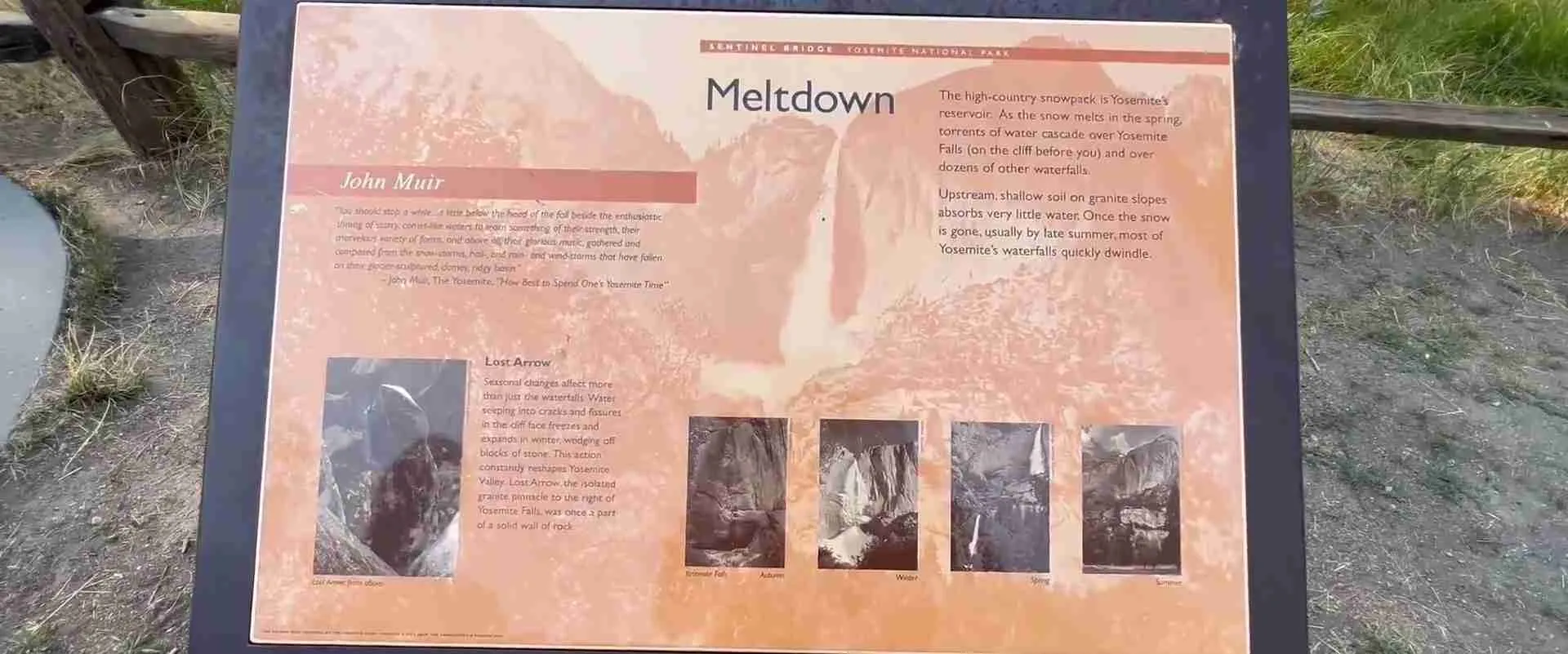
Yosemite Falls exemplifies this process, dropping 2,425 feet in three stages from its hanging valley. The upper fall plunges 1,430 feet, the middle cascades drop 675 feet over a steep slope, and the lower fall adds another 320 feet. Bridalveil Fall, Ribbon Fall, and numerous seasonal waterfalls throughout the valley formed through the same hanging valley mechanism. Spring snowmelt creates peak flow, with some falls becoming mere trickles or disappearing entirely during dry summer and fall months. The waterfalls’ seasonal variation reflects the Mediterranean climate’s wet winter and dry summer pattern.
How Do Joint Patterns Control Yosemite’s Rock Formations?
Joints are fractures in rock where no significant movement has occurred, and in Yosemite’s granite, joint patterns profoundly influence erosion and cliff formation. As granite cooled underground, it contracted and developed fractures. Additional joints formed as overlying rock eroded away, releasing pressure and allowing the granite to expand and crack. These joint systems create zones of weakness where water can penetrate, freezing and thawing to gradually break apart rock.
Cathedral Rocks demonstrates how vertical and horizontal joints create stepped cliff faces and prominent spires. The Three Brothers formation shows three massive buttresses separated by joint-controlled gullies, with each “brother” representing more resistant granite between major fracture zones. Royal Arches displays curved joints concentric with the cliff face, creating arch-shaped features through exfoliation. Understanding joint patterns helps geologists predict rockfall hazards and enables rock climbers to identify routes up seemingly impossible cliffs.
Extended multi-day tours – 5+ days
Featured Park Yosemite National Park Multi-Day Tour Packages

3 days
Park Yosemite National Park 3-Day Discovery Tour
- ✓ Comprehensive Park Yosemite National Park experience
- ✓ Expert local guides included
- ✓ All accommodation included
- ✓ Transportation provided

5 days
Park Yosemite National Park 5-Day Highlights Experience
- ✓ Comprehensive Park Yosemite National Park experience
- ✓ Expert local guides included
- ✓ All accommodation included
- ✓ Transportation provided

7 days
Park Yosemite National Park 7-Day Cultural Journey
- ✓ Comprehensive Park Yosemite National Park experience
- ✓ Expert local guides included
- ✓ All accommodation included
- ✓ Transportation provided
10 days
Park Yosemite National Park 10-Day Complete Adventure
- ✓ Comprehensive Park Yosemite National Park experience
- ✓ Expert local guides included
- ✓ All accommodation included
- ✓ Transportation provided
Multi-day tour packages powered by TourRadar. Prices and availability subject to change.
The Grand Architecture of Yosemite Valley
Yosemite Valley stretches seven miles long and averages one mile wide, with walls rising 3,000-4,000 feet on both sides. This U-shaped profile characterizes glacially carved valleys, contrasting sharply with the V-shaped profiles of river-carved canyons. Before glaciation, the Merced River had carved a narrow canyon perhaps 1,000 feet deep. Repeated glaciations over the past 2-3 million years transformed this canyon into the broad valley visible today, with the most recent major glaciation ending about 15,000 years ago.
The valley’s floor remains remarkably flat, covered with alluvial deposits and meadows. Ancient Lake Yosemite once filled the valley after glaciers retreated, created when glacial debris blocked drainage downstream. Sediment carried by the Merced River gradually filled this lake, creating the flat valley floor. Borings and excavations have revealed lake sediments extending to bedrock depths of 2,000 feet below the current valley floor, indicating how deeply glaciers carved the valley. The flat floor and steep walls create the distinctive profile that makes Yosemite Valley so visually striking.
Each major formation lining the valley represents different granite types with varying resistance to erosion. El Capitan consists of El Capitan Granite, a coarse-grained, sodium-rich granite with excellent structural integrity. Cathedral Rocks formed from Cathedral Peak Granodiorite, slightly different in composition and displaying more prominent joint systems. Half Dome comprises the youngest granite in the valley, about 87 million years old, with large feldspar crystals giving it distinctive appearance and strength.
The valley’s southern wall features a series of prominent features including Sentinel Rock, Sentinel Dome, and Glacier Point. Sentinel Rock rises 3,000 feet as a monolithic formation separated from the main wall by joint patterns and differential erosion. Glacier Point provides the classic viewpoint over the valley, situated on more resistant granite that forms a promontory. The North Wall includes Washington Column, North Dome, and Basket Dome, each displaying characteristic joint patterns and exfoliation features that create their distinctive shapes.
El Capitan: The Monolith
El Capitan dominates the northern wall of Yosemite Valley, rising 3,000 feet from base to summit with dimensions of approximately 1.5 miles wide and 1 mile tall. The formation consists of a single granite pluton that cooled underground about 100 million years ago, creating rock with exceptional strength and minimal fracturing. The name “El Capitan” derives from Spanish explorers who called it “El Capitán,” while indigenous Ahwahneechee people knew it as “To-to-kon oo-lah,” meaning “Chief of the Valley.”
The southwest face, visible from popular viewpoints in the valley, presents the most dramatic perspective on this massive formation. The near-vertical wall displays subtle features despite its seeming blankness – vertical crack systems, variations in granite texture, and the famous “Nose” route that follows a prominent prow extending from the face. Closer examination reveals dikes of darker rock cutting through the main granite, representing molten intrusions that occurred during the pluton’s formation. These dikes provide some of the few horizontal features on an otherwise remarkably uniform face.
Rock climbers pioneered routes up El Capitan beginning in 1958, when Warren Harding led the first ascent via the Nose route after 47 days of climbing spread over 18 months. This achievement demonstrated that previously “impossible” faces could be climbed with new techniques and determination. Today, climbers from around the world attempt El Capitan via dozens of established routes, with ascents ranging from multi-day epics to speed climbs completing the wall in hours. The climbing community’s detailed knowledge of El Capitan’s features rivals that of professional geologists, with climbers naming and documenting every crack, ledge, and feature across the face.
The summit of El Capitan presents dramatic contrast to the sheer face, with relatively gentle slopes covered by forest. This difference reflects the geological structure, with the southwest face representing a zone where the granite resisted erosion while surrounding rock wore away. The summit provides views across Yosemite Valley and into the high country, though most visitors view El Capitan from below rather than ascending to the top. The formation’s mass influences local weather patterns, creating updrafts that birds of prey use for soaring and affecting cloud formation in the valley.
Half Dome: Icon of Yosemite
Half Dome rises 4,737 feet above sea level, with its summit standing nearly 5,000 feet above Yosemite Valley floor. The formation measures approximately 1,400 feet tall from the saddle at its base to the summit, with the northwest face presenting an 800-foot sheer cliff that appears impossible to scale. The southeast face shows the characteristic smooth, curved profile created by exfoliation, with sheets of granite peeling away to create the dome’s distinctive shape.
Geologists classify Half Dome as a quartz monzonite, similar to granite but with slightly different mineral ratios. The rock formed approximately 87 million years ago from a late-stage intrusion in the Sierra Nevada batholith. The relatively young age compared to surrounding granite, combined with the rock’s particular mineral composition, created exceptionally strong stone with few natural fractures. This strength enabled Half Dome to resist erosion while surrounding rock wore away, leaving the dome standing prominently above the landscape.
The dome’s exfoliation patterns fascinate geologists studying rock weathering processes. Curved sheets of granite, some several inches thick and others reaching several feet, separate along planes roughly parallel to the surface. As sheets separate, they form natural arch patterns and create the smooth, curved faces characteristic of granite domes. Fresh rockfalls reveal bright, unweathered granite beneath weathered exterior surfaces, demonstrating the ongoing nature of exfoliation. Major rockfall events occur periodically, with significant falls documented in 1870, 1996, 2009, and other years, reminding observers that even massive formations change continuously.
The cables route to Half Dome’s summit, installed in 1919, enables hikers to reach the top during summer months. The trail ascends the southeast face using a system of steel cables anchored to the granite, with wooden crosspieces providing footholds on the steep final 400 feet. Before cables were installed, reaching the summit required technical climbing skills. George Anderson made the first ascent in 1875 using hand-drilled holes and iron spikes. Today, hundreds of hikers reach the summit daily during peak season, though the steep exposure and physical demands make this one of Yosemite’s most challenging day hikes.
Yosemite Falls and the Hanging Valleys
Yosemite Falls dominates the northern valley wall, dropping 2,425 feet in three distinct sections. The upper fall plunges 1,430 feet as a near-vertical cascade, creating the most dramatic single drop. The middle cascades descend 675 feet over a steep slope, visible primarily from closer viewpoints or higher elevations. The lower fall completes the descent with a 320-foot drop into the pool at its base. Combined, these sections make Yosemite Falls the fifth-tallest waterfall in the world and the tallest in North America.
Yosemite Creek feeds the falls, draining a watershed of approximately 46 square miles in the park’s high country. Spring snowmelt creates peak flow, with the falls often reaching their maximum volume in May. The roar of falling water during peak flow echoes throughout the valley, and spray creates a mist visible from great distances. By late summer, flows diminish dramatically, with the falls sometimes reduced to a trickle or disappearing entirely during drought years. This seasonal variation contrasts with waterfalls fed by consistent groundwater, making Yosemite Falls a dynamic feature that changes character throughout the year.
The hanging valley phenomenon that created Yosemite Falls operates throughout the park. Bridalveil Fall drops 620 feet from its hanging valley, with wind often blowing the spray sideways, creating the “bridal veil” effect. The fall flows year-round, fed by a watershed that maintains base flows even during dry periods. Ribbon Fall, visible from valley viewpoints, drops 1,612 feet as a single plunge, making it the tallest single-drop waterfall in North America. However, Ribbon Fall flows only during spring snowmelt, disappearing completely by early summer most years.
Dozens of seasonal waterfalls appear throughout Yosemite Valley during spring snowmelt, cascading from hanging valleys carved by small tributary glaciers. Horsetail Fall, on El Capitan’s eastern edge, gains fame during February when sunset light can create a “firefall” effect, making the water appear to glow orange and red. Silver Strand Falls, Lehamite Falls, and Sentinel Falls represent just a few of the ephemeral cascades that transform the valley’s appearance after storms or during spring melt. These seasonal falls demonstrate the continued active erosion of the valley walls, carrying sediment and sculpting the landscape.
Cathedral Rocks and Spires
Cathedral Rocks rise majestically on the south wall of Yosemite Valley, forming a series of three prominent spires reaching approximately 2,600 feet above the valley floor. The central spire presents the most dramatic profile, with steep faces on all sides creating a pointed summit. These formations demonstrate how joint patterns control erosion, with vertical fracture zones separating the spires and horizontal joints creating stepped profiles on their faces.
The granite composing Cathedral Rocks, known as Cathedral Peak Granodiorite, differs slightly from El Capitan Granite in mineral composition and joint characteristics. This granodiorite contains more plagioclase feldspar and slightly less quartz than typical granite, with medium-sized crystals creating a relatively uniform texture. The rock’s jointing patterns proved more conducive to erosion than El Capitan’s massive granite, allowing glaciers and weathering to carve the distinctive spires rather than leaving a monolithic wall.
Cathedral Spires, smaller formations adjacent to Cathedral Rocks, display even more pronounced vertical joints. These narrow spires demonstrate how erosion exploits zones of weakness, removing rock along fracture planes while more massive sections between joints remain standing. The spires attract rock climbers seeking technical routes on high-quality granite, with classic climbing routes following crack systems up seemingly smooth faces. The formations’ shapes change continuously through erosion, though at timescales imperceptible to human observation.
Leaning Tower, another prominent formation on the valley’s south wall, demonstrates how joint patterns create unusual shapes. This 1,000-foot granite formation leans at a dramatic angle, created by a combination of joint orientation and differential erosion. The tower’s distinctive tilt makes it a landmark visible from many valley locations, while climbers appreciate its challenging routes and exposed positions. These smaller formations throughout the valley complement the massive walls, creating visual complexity and demonstrating the variety of forms granite can assume under different erosion conditions.
Granite Domes of the High Country
Beyond Yosemite Valley, the park’s high country features extensive granite domes showcasing exfoliation at landscape scale. Sentinel Dome, accessible via short trail from Glacier Point Road, rises 4,000 feet above the valley floor with a smooth, rounded summit. The dome’s exfoliation sheets create natural steps that enable hikers to reach the top, where 360-degree views encompass the valley, high peaks, and distant horizons. A solitary Jeffrey pine once grew from the dome’s summit, becoming one of the world’s most photographed trees before dying in the 1970s.
North Dome stands on the valley’s north rim, presenting a massive rounded summit visible from many valley viewpoints. The dome rises to 7,542 feet elevation, with its smooth surfaces created by countless exfoliation events over millions of years. Unlike Half Dome’s dramatic cliff face, North Dome demonstrates classical dome formation with gradual curves and gentle slopes on all sides. The formation provides a textbook example of how massive, sparsely jointed granite erodes into dome shapes when exposed at the surface.
Tuolumne Meadows region features extensive dome fields, with formations of all sizes dotting the landscape. Pothole Dome, a relatively small formation near the meadows, displays well-developed exfoliation and provides easy access for visitors to examine the process up close. Lembert Dome rises dramatically above the meadows, its smooth back slope contrasting with the steep downstream face. This asymmetry reflects glacial erosion, with ice flowing up and over the dome’s back side, smoothing the surface, while plucking rock from the steeper downstream face.
Fairview Dome, reaching 9,731 feet, dominates the western approach to Tuolumne Meadows. The massive dome displays classic exfoliation patterns, with curved sheets of granite creating a smooth, light-colored surface. The dome’s prominence made it a landmark for early travelers crossing the Sierra Nevada. Climbers developed numerous routes on the dome’s faces, though its relatively remote location keeps it less crowded than valley formations. The dome fields of the high country demonstrate how extensive granite exposures and exfoliation processes operated across the Sierra Nevada, with Yosemite Valley representing just one dramatic example of these widespread phenomena.
Glacial Polish and Erratics
Glacial polish appears throughout Yosemite on bedrock surfaces where moving ice ground away irregularities, leaving smooth, sometimes reflective surfaces. The polish results from fine sediment embedded in the glacier’s base acting as abrasive, combined with the enormous pressure of ice thousands of feet thick. The Tioga Road near Olmsted Point provides excellent examples of glacial polish, with smooth granite surfaces showing striations indicating ice flow direction. These striations, parallel grooves carved by rocks embedded in the glacier’s base, preserve evidence of ice movement thousands of years after glaciers disappeared.
Pothole Dome demonstrates exceptionally well-preserved glacial polish, with visitors able to walk across smooth surfaces and observe striation patterns. The polish’s preservation depends on protection from weathering, as exposure to rain, freeze-thaw cycles, and plant growth gradually roughens polished surfaces. Some polish survived because ice protected it until recently, while other areas lost their polish thousands of years ago. Comparing polished and weathered surfaces helps geologists reconstruct glacial history and estimate how long ago ice disappeared from different areas.
Glacial erratics scattered throughout Yosemite provide additional evidence of ice age activity. These boulders, often differing in composition from underlying bedrock, were transported by glaciers and deposited when ice melted. Some erratics perch precariously on smooth bedrock surfaces, apparently defying gravity. The boulders’ positions indicate ice thickness, as glaciers must have been tall enough to carry the rocks to their current locations. Geologists use erratic distribution to map ice extent and reconstruct glacial flow patterns.
Roches moutonnées (sheep rocks) display asymmetric profiles created by glacial erosion, with smooth, gently sloping upstream faces contrasting with steep, fractured downstream faces. As glaciers flowed over these bedrock knobs, ice abraded the upstream side into smooth surfaces while plucking rock from the downstream side, creating the characteristic shape. Numerous examples appear throughout the high country, with Lembert Dome representing an exceptionally large roche moutonnée. These formations demonstrate how ice flow direction influenced erosion patterns, with the asymmetry providing clear indicators of glacial movement.
Tuolumne Meadows and Subalpine Landscape
Tuolumne Meadows stretches along the Tuolumne River at approximately 8,600 feet elevation, forming the largest subalpine meadow in the Sierra Nevada. The meadow extends for several miles, with lush grasses, wildflowers, and wetlands contrasting with surrounding granite domes and peaks. Glacial deposits created the conditions for meadow formation, with terminal moraines damming drainage and creating shallow lakes. Sediment carried by the Tuolumne River gradually filled these lakes, while groundwater maintains the meadow’s wetland character.
The meadow’s vegetation reflects the short growing season and harsh conditions of subalpine environments. Grasses dominate, interspersed with sedges in wetter areas and wildflowers creating spectacular displays during peak bloom in July and August. Lodgepole pine forests surround the meadows, with individual trees sometimes growing in the meadow itself, indicating gradual forest encroachment. This encroachment reflects both natural succession and fire suppression policies that historically prevented natural fires from maintaining open meadows.
The Tuolumne River meanders through the meadows in a classic pattern of curves and oxbows, demonstrating how rivers behave in low-gradient landscapes. During spring snowmelt, the river floods portions of the meadow, depositing sediment and nutrients. By late summer, flows diminish, and the river’s character changes dramatically. This seasonal variation influences the ecosystem, with different plant and animal species adapted to specific moisture regimes and timing.
Dana Meadows, at the park’s eastern boundary, represents another significant subalpine meadow system. Located at approximately 10,000 feet elevation, this meadow experiences even more extreme conditions than Tuolumne Meadows, with snow covering the landscape for much of the year. The meadow’s vegetation includes hardy alpine species, with stunted trees marking treeline conditions. These high-elevation meadows provide critical habitat for wildlife and serve as important water storage areas, releasing snowmelt gradually throughout summer.
Giant Sequoias: Living Architecture
Mariposa Grove contains approximately 500 mature giant sequoias (Sequoiadendron giganteum), making it one of the largest and most accessible groves of these massive trees. The sequoias reach heights exceeding 250 feet and diameters of 20-30 feet, with the largest specimens representing some of the most massive living organisms on Earth. The Grizzly Giant, estimated at approximately 2,700 years old, demonstrates the species’ extraordinary longevity, with its massive branches measuring larger in diameter than most other tree species’ trunks.
Giant sequoias possess numerous adaptations enabling their exceptional size and longevity. Bark reaches thicknesses of 12-18 inches, providing excellent insulation against fire while protecting the living tissue beneath. The bark contains tannins that deter insect attack and resist rot, helping trees survive for millennia. Root systems spread widely but remain relatively shallow, typically extending no more than 6-10 feet deep. The shallow roots create vulnerability to windthrow, yet the massive trunk’s taper and the wide root spread generally provide adequate stability.
Fire ecology plays a crucial role in giant sequoia reproduction and grove health. Sequoia cones remain closed for years, opening primarily in response to fire heat. The cones, small relative to the tree’s size at only 2-3 inches long, contain numerous tiny seeds. Fire clears competing vegetation, creates mineral soil beds ideal for germination, and opens the canopy allowing sunlight to reach seedlings. Without fire, shade-tolerant species like white fir invade sequoia groves, eventually excluding sequoia regeneration. Historical fire suppression contributed to grove deterioration, prompting modern managers to reintroduce prescribed fire.
The California Tunnel Tree, carved in 1895 to allow carriages to pass through, demonstrates both sequoias’ massive size and historical misuse of these ancient trees. While the practice of cutting tunnels through living trees ended decades ago, the tunneled trees that survived serve as reminders of different attitudes toward natural resources. The trees’ ability to survive such trauma testifies to their resilience, though the practice significantly stressed the trees and shortened their potential lifespans. Today, protection and restoration efforts prioritize maintaining natural grove conditions and allowing ecological processes to operate without excessive human interference.
Vernal and Nevada Falls: The Giant Staircase
The Merced River creates Yosemite’s “Giant Staircase” as it descends from the high country to Yosemite Valley, with Vernal Fall and Nevada Fall representing the two major steps. Nevada Fall drops 594 feet over a cliff of smooth granite, presenting a nearly vertical drop that creates powerful turbulence at the base. The fall’s volume varies dramatically between spring snowmelt and late summer, with the massive curtain of water narrowing to a fraction of its peak width during dry periods.
Vernal Fall, downstream from Nevada Fall, plunges 317 feet in a nearly vertical cascade that often creates significant spray. The Mist Trail, ascending alongside the fall, brings hikers through spray zones where perpetual mist supports lush vegetation unusual in the generally dry Sierra Nevada. The spray creates rainbows visible on sunny days, adding to the fall’s spectacular character. Both falls formed where the Merced River crosses bands of particularly resistant granite, with differential erosion creating the cliffs over which water now plunges.
The Liberty Cap formation, a massive dome between the two falls, demonstrates classical exfoliation processes. Glaciers flowed around Liberty Cap during the Ice Age, smoothing its surfaces and creating the distinctive shape. The cap’s prominence influences the Merced River’s course, with water forced around the formation’s base. The dome’s name derives from its resemblance to liberty caps worn during the American Revolutionary period, though the formation’s creation predates human history by millions of years.
Emerald Pool and Silver Apron, located between Vernal and Nevada Falls, provide dramatic evidence of the Merced River’s continued erosive power. Emerald Pool’s green-tinted water collects in a basin carved by water’s swirling action, with the color resulting from light reflection off the granite bottom. Silver Apron, a smooth granite slope polished by flowing water, demonstrates how the river continues sculpting bedrock. During spring runoff, the Merced’s power becomes obvious as massive volumes of water thunder down the staircase, carrying sediment and gradually deepening the canyon.
Conservation of Geological Features
Protecting Yosemite’s geological features requires managing both natural processes and human impacts. Rockfall represents a significant ongoing process, with formations throughout the park experiencing periodic collapses. Major rockfalls in 1996 and 2017 reminded visitors that Yosemite’s landscape remains dynamic, with gravity and weathering constantly modifying cliffs. The park monitors unstable formations, restricts access to high-risk areas, and educates visitors about rockfall danger. However, complete prevention proves impossible, as rockfall represents a natural process essential to the landscape’s evolution.
Visitor impacts on geological features require careful management. Foot traffic gradually erodes rock surfaces, particularly at popular viewpoints where millions of visitors concentrate. Climbers’ activities affect rock faces through chalk residue, fixed anchors, and increased rockfall risk from disturbed formations. The park balances access with protection, establishing trails to concentrate traffic while allowing natural areas to remain undisturbed. Restoration efforts remove unauthorized trails, replant vegetation in damaged areas, and sometimes close sensitive features to allow recovery.
Climate change creates new challenges for managing Yosemite’s geological features. Reduced snowpack affects waterfall flows, with iconic cascades potentially drying earlier in summer. Changed precipitation patterns influence erosion rates, freeze-thaw cycles, and vegetation distributions. Glaciers and permanent snowfields continue shrinking, with some features that persisted for thousands of years disappearing within decades. Park scientists monitor these changes while recognizing that geological processes operate across timescales far exceeding human civilization.
Research programs investigate fundamental questions about Yosemite’s geology while providing information needed for management decisions. Studies of rockfall triggers help predict future events and inform safety protocols. Glacial geology research reconstructs ice age history and provides context for understanding current landscape. Exfoliation studies reveal mechanisms driving dome formation and help estimate future rockfall potential. This ongoing research ensures that management decisions rest on solid scientific understanding while advancing knowledge of geological processes applicable far beyond Yosemite.
Frequently Asked Questions
What type of rock makes up most of Yosemite’s formations?
Granite and closely related rocks like granodiorite comprise most of Yosemite’s prominent formations. These rocks formed underground from slowly cooling molten rock between 120-80 million years ago, creating the Sierra Nevada batholith. Different granite types with varying mineral compositions and cooling rates form distinct units, each with characteristic appearance and erosion resistance. El Capitan Granite, Half Dome Granodiorite, and Cathedral Peak Granodiorite represent major rock types, each creating distinctive formations.
Are glaciers still present in Yosemite?
Small glaciers and permanent snowfields exist in the park’s highest elevations, primarily around Mount Lyell and Mount Maclure. These features represent remnants of the last ice age rather than active alpine glaciers in the classical sense. Climate change has dramatically reduced their extent, with some ice features present at the park’s establishment now completely melted. The current small ice bodies bear little resemblance to the massive glaciers that carved Yosemite Valley, which reached thicknesses of 4,000 feet and extended far beyond current park boundaries.
How fast do Yosemite’s formations change?
Geological change occurs across timescales from instantaneous (rockfalls) to millions of years (major erosion). Exfoliation and weathering proceed gradually, with individual sheets separating over decades to centuries. Major rockfalls occur sporadically, with significant events documented every few years to decades. Water erosion continues carving valleys and sculpting waterfalls, though changes remain imperceptible over human lifespans. Climate operates on intermediate timescales, with ice age glaciation occurring over tens of thousands of years. Understanding these multiple timescales helps appreciate both the landscape’s stability and its continuous evolution.
Why do some waterfalls flow year-round while others disappear?
Watershed characteristics determine waterfall permanence. Falls fed by large watersheds with consistent groundwater, like Bridalveil Fall, maintain base flows even during drought. Smaller watersheds dependent primarily on snowmelt produce seasonal falls that disappear when the annual snowpack melts completely. Climate patterns influence timing and duration, with heavy snow years extending flows while drought years abbreviate the season. Yosemite Falls’ dramatic seasonal variation reflects its dependence on snowmelt, while Bridalveil’s more stable flow indicates groundwater contributions.
What causes the different colors visible in Yosemite’s granite?
Mineral composition and weathering create color variations in granite. Fresh, unweathered granite appears light gray to white, with color variations reflecting feldspar and quartz ratios. Iron-bearing minerals like biotite create dark streaks and patches. Weathering produces orange, brown, and red stains as iron oxidizes, similar to rust formation. Lichens colonizing rock surfaces create black, orange, and green patches. Waterfalls and seeps create particularly prominent staining, with mineral-laden water leaving deposits as it evaporates. These color variations add visual interest while providing information about rock composition and weathering processes.
How do rock climbers affect Yosemite’s geological features?
Climbing impacts include chalk residue, fixed anchors, and minor surface polishing on popular routes. However, these impacts remain minimal compared to natural weathering processes affecting massive formations like El Capitan. The National Park Service regulates climbing through permits and restrictions on certain routes, balancing recreational access with resource protection. Studies indicate that climbing-related impacts, while visible up close, don’t significantly alter large-scale geological features or processes. The primary concern involves visual impacts and ensuring that bolts and fixed gear placement follows minimum-impact practices.
What is the origin of Yosemite’s distinctive granite?
The Sierra Nevada batholith formed during subduction of the Farallon Plate beneath the North American Plate between 120-80 million years ago. Molten rock generated by the subduction process rose through Earth’s crust, cooling slowly underground to form granite. Different magma batches with varying compositions created the distinct granite types visible today. Subsequent uplift and erosion removed overlying rock, exposing the granite at the surface. The batholith extends for hundreds of miles along the Sierra Nevada, with Yosemite showcasing particularly impressive examples of this vast igneous complex.
Why don’t trees grow on granite domes?
Granite domes lack soil necessary for tree growth, with smooth exfoliation surfaces providing no substrate for root establishment. The steep slopes and smooth rock prevent organic material from accumulating, while the exposed positions subject any pioneer plants to extreme conditions. However, trees establish in fractures where soil accumulates and water collects, creating distinctive patterns where vegetation follows joint systems. The contrast between bare rock and vegetated areas highlights how small differences in substrate and moisture determine what can grow, creating the characteristic partially vegetated appearance of many formations.
How does exfoliation differ from regular erosion?
Exfoliation represents a specific erosion mechanism where concentric sheets of rock separate parallel to the surface, like layers peeling from an onion. The process occurs primarily in massive granite as pressure from overlying rock is removed through erosion, allowing the granite to expand. Chemical weathering along separation planes weakens the rock, and eventually gravity and freeze-thaw cycles cause sheets to fall away. Regular erosion includes multiple processes like water and ice acting in fractures, chemical dissolution, and mechanical breakdown. Exfoliation creates the smooth, curved profiles characteristic of granite domes, distinguishing it from erosion that follows existing fracture patterns.
What evidence shows that Yosemite was shaped by glaciers?
Multiple lines of evidence confirm glacial action: U-shaped valley profiles, hanging valleys creating waterfalls, glacial polish and striations on bedrock, erratic boulders transported from distant sources, moraines marking ice margins, and distinctive landforms like roches moutonnées. The combination and consistency of these features leave no doubt about glacial origin. Scientists reconstruct ice extent, thickness, and flow patterns from this evidence, revealing that Yosemite Valley once lay beneath 4,000 feet of ice. The evidence demonstrates how profoundly glaciation modified the landscape, transforming a river-carved canyon into the spectacular valley visitors see today.