Gargano Coastal & High-Plateau Circuit: The Alternative Road Trip Guide 2026
The Gargano Promontory compresses a remarkable variety of driving terrain into a single self-contained loop: 170 kilometres of Adriatic cliff corniche, beech-forest plateau, medieval watchtower headlands, and UNESCO pilgrimage roads that climb from sea level to 800 metres in under twenty kilometres. This guide breaks the 2026 circuit into four driving days, maps the access logistics for Foresta Umbra and Monte Sant’Angelo, and details the seasonal regulations, parking systems, and road characteristics that determine whether an independent driver moves freely or spends peak-season mornings stuck behind a campervan on a single-track cliff bend.
Key Takeaways
- The full circuit covers approximately 170 km of coastal road plus a 40 km forest loop — plan four driving days with Vieste as the natural eastern hub; budget travellers spend €80–120 per person daily (two sharing budget accommodation), mid-range travellers €135–210, with a complete five-day circuit including car rental share running €470–700 (budget) or €785–1,225 (mid-range) per person.
- Foresta Umbra entry is free and car access is open year-round with designated parking at the visitor centre; the reservation-only shuttle from Vieste runs on Wednesday mornings in summer for guided tour participants — independent drivers do not need it.
- Monte Sant’Angelo operates a restricted traffic zone (ZTL) covering its historic centre; park at the designated lots at Parcheggio Via Carlo d’Angiò or the Zona Castello car parks before walking in, and allow at least three hours for the sanctuary and old town.
- Rent a compact car — the SP52, SP52 Bis, and SP53 coastal and forest roads are narrow throughout, with frequent single-lane-width passages through cliff vegetation and beech forest; larger vehicles cause significant delays during peak season.
- Peak season (July–August) fills beach layby parking along SP53 by 9 AM; start coastal driving stages before 8:30 or plan stops for late afternoon when the morning crowd has departed.
- Phone signal is unreliable inside Foresta Umbra and patchy on cliff sections of the SP53 — download offline maps before leaving the last major town and carry paper backup navigation for the forest plateau.
People Also Ask About the Gargano Road Trip 2026
How much does the Gargano road trip cost per person in 2026?
Budget travellers sharing budget accommodation spend €80–120 per person daily, covering a shared room, two meals, fuel share, and minor attraction costs. Mid-range travellers spend €135–210 per person daily with comfortable hotels and seafood restaurants. Add car rental shared between two people — €70–100 extra per person for a five-day economy rental, or €110–175 for a mid-range vehicle — and a complete five-day circuit costs €470–700 per person on a budget or €785–1,225 per person at mid-range comfort. These figures exclude flights and intercity travel to the Gargano gateway city of Foggia or Manfredonia. Luxury travellers in boutique masserias and fine-dining restaurants invest €285–420 per person daily, with five-day totals of €1,600–2,375.
Do you need a permit or access pass to drive into Foresta Umbra in 2026?
No permit is required for independent car access to Foresta Umbra in 2026. The forest is open to private vehicles year-round, with free designated parking at the visitor centre in the Baracconi locality and at key trailhead nodes. A reservation-only shuttle from Vieste operates on Wednesday mornings in summer, but it serves guided trekking and e-bike tour participants — independent drivers choose their own arrival time by car. In August, public bus services connect Foresta Umbra to Foggia, San Severo, Rodi Garganico, and Vico del Gargano; schedules change annually, so confirm the current timetable before relying on this option.
What car should I rent for the Gargano circuit in 2026?
A compact or small car is the right choice. The cliff-hugging SP53 between Vieste and Mattinata and the forest road SP52 Bis both narrow substantially through curves, and a full-size SUV or minivan regularly causes delays when meeting oncoming traffic. Campervans are not prohibited but create significant bottlenecks on the SP52 Bis forest ascent. A compact diesel with full coverage insurance is the practical optimum — it clears tight bends, parks easily in Vieste’s historic district apron, and reaches good fuel economy on the long upland traverse. Never leave valuables visible inside: car break-ins are more common in Puglia than in most Italian regions, particularly at popular beach laybys along the coastal road.
When is the best time to drive the Gargano coastal road in 2026?
Late May through mid-June and the whole of September offer the most rewarding combination of open facilities, mild temperatures, and manageable traffic. The SP53 coastal road is at its dramatic best in morning light before beach traffic builds, and the Foresta Umbra beech canopy goes through a spectacular colour transition in October. July and August are navigable but demanding: beach laybys along SP53 fill before 9 AM, the Vieste–Peschici SP52 coastal road sees heavy tourist movement, and Foresta Umbra car parks fill quickly on clear weekends. Winter driving is possible but requires winter tyres or chains on the Monte Sant’Angelo and Foresta Umbra plateau roads between 15 November and 15 April — check rental agency tyre policy before setting out in the cooler months.
Extended multi-day tours – 5+ days
Featured Puglia Multi-Day Tour Packages
7 days
Taste of Salento-Authentic Culinary Experience
- ✓ Comprehensive Puglia tour
- ✓ Expert local guides included
- ✓ All accommodation arranged
- ✓ Transportation provided

7 days
7-Day Puglia Essence: Alberobello, Otranto and Lecce, Private Tour
- ✓ Comprehensive Puglia tour
- ✓ Expert local guides included
- ✓ All accommodation arranged
- ✓ Transportation provided
8 days
Highlights of Puglia
- ✓ Comprehensive Puglia tour
- ✓ Expert local guides included
- ✓ All accommodation arranged
- ✓ Transportation provided

8 days
Highilights of Apulia, 8 day Tour from Bari to Bari
- ✓ Comprehensive Puglia tour
- ✓ Expert local guides included
- ✓ All accommodation arranged
- ✓ Transportation provided
Multi-day tour packages powered by TourRadar. Prices and availability subject to change.
Gargano in 2026: The Case for Driving the Alternative Circuit
Most travellers who come to the Gargano do one of two things: they drive straight to Vieste, park the car, and spend a week on the beach — or they drive the SP53 coastal road as a day excursion from a fixed base in Vieste or Peschici. Both approaches are enjoyable. Neither one gives you the Gargano.
The promontory that juts from the heel of the Italian boot into the Adriatic is in fact two completely different landscapes stacked on top of each other. At sea level, you have one of the most dramatic coastlines in Italy: white limestone cliffs falling vertically into turquoise water, natural sea arches, fishing platforms built on headlands, medieval defensive towers on every promontory, and small harbour towns that feel geographically remote even when they are full of visitors. Above 600 metres, the picture changes entirely. The Gargano plateau is covered by Foresta Umbra — a surviving ancient forest of beech, yew, hornbeam, and holm oak that once covered much of the southern Apennines — and by towns like Monte Sant’Angelo that spent a millennium as pilgrimage destinations for half of Christian Europe. These two worlds are separated by fewer than twenty vertical kilometres of provincial road, but they feel like different countries. The standard Gargano holiday visits one or the other; the road trip visits both.
The alternative circuit in this guide uses the SP53 and SP52 coastal roads as the first two driving days and the SS89 Garganica inland road and SP52 Bis forest road as the second two, forming a loop that returns to Manfredonia from Monte Sant’Angelo. It is the same total distance you might drive in a single day on a motorway — but the road character makes speed irrelevant. The SP53 between Vieste and Mattinata requires your full attention because the bends come without warning and the drop to the sea below the crash barriers is several hundred metres. The SP52 Bis through Foresta Umbra requires patience because the beech canopy closes overhead and visibility drops to the next corner. Both demand a compact car, offline navigation, and a willingness to pull over for the view.
The Gargano National Park encompasses the whole promontory and is among the largest protected areas in peninsular Italy. Formal access restrictions within the national park are limited — there is no general entry fee and no permit system for driving the main road network — but the park’s management of specific sites such as Foresta Umbra and the beach access points does produce practical constraints that vary by season. Understanding them before you arrive is the difference between a fluid circuit and a morning spent looking for parking.
Vieste, the easternmost point of the Gargano and the town that sits at the junction of the southern SP53 and northern SP52 coastal roads, is the natural hub for any circuit that divides the coast from the interior. It provides the widest choice of accommodation on the promontory, the best fuel supply before the coastal legs, and the morning ferry and boat-tour connections that make the off-road coastline accessible by sea when the cliff paths are too demanding on foot. The circuit described here uses Vieste as the overnight node between the two coastal days and the pivot point before turning inland.
Manfredonia, on the southern base of the promontory, is the recommended gateway for arrivals by train from Foggia. It sits at the foot of the road to Monte Sant’Angelo and gives the circuit a clean return point on Day 4 that avoids retracing any coastal kilometres already covered. Arrivals from the north (from the A14 motorway) enter more naturally at Rodi Garganico or Peschici and can run the circuit in the reverse direction without any structural difference.
Route Architecture: Connecting Maritime Promontories to Mountain Sanctuaries
The circuit has four driving days and a total road distance of approximately 210 km when the Foresta Umbra loop and the Monte Sant’Angelo descent are added to the coastal arc. Each day is short in kilometres but long in time, because every road section rewards stopping. The daily stages described below assume one overnight in Vieste after the first coastal leg, a second in or near Peschici after the northern coastal day, a third at Monte Sant’Angelo after the forest traverse, and a return to Manfredonia on Day 4. Variations are noted where terrain permits a different pacing.
Day 1–2: Coastal Watchtower Circuit and Trabucchi Access Nodes
The SP53 between Mattinata and Vieste is widely described as one of the most spectacular coastal roads in all of Puglia, and this characterisation is accurate without qualification. The road hugs the Gargano cliff coast for approximately 30 km, running above a sequence of near-vertical white limestone drops to a sea that shifts from turquoise to deep blue as the water deepens. Plan a minimum of 90 minutes for the drive even without stopping — with stops at the miradors, the Arch of San Felice natural sea arch, and the Zagare Bay sea-stack viewpoint, a half-day is a realistic commitment.
The departure point for Day 1 is Mattinata, a quiet agricultural town at the southern base of the Gargano cliff coast, approximately 40 km from Manfredonia on the SS89. Mattinata sits just before the SP53 coastal section begins, and it is the last convenient fuel station before Vieste — fill up here, because there is no service station on the cliff road itself. From Mattinata, the SP53 begins climbing almost immediately, and the first viewpoints appear within the first four kilometres.
The first major stop northbound is the viewpoint above Zagare Bay, where two tall limestone sea stacks (faraglioni) rise from the water below a cliff wall of particular geological drama. The laybys here can hold five or six cars; in July and August they fill before 9 AM. If you arrive to find them full, the return south after your coastal drive is equally rewarding from this direction. Continuing north, the Vignanotica Bay turnoff appears approximately halfway along the SP53 section. Vignanotica Bay is a remote shingle-and-limestone cove reached by a 5 km trail from the SP53 trailhead — in summer a shuttle bus connects the trailhead parking to the beach, but the seasonal schedule changes yearly, so verify before planning this as a primary stop. The trail is moderate in difficulty and rewards with views over the Adriatic back toward the Albanian coast on clear days.
The Arch of San Felice is one of the Gargano coast’s most photographed natural formations — a limestone sea arch with a span broad enough to pilot a small boat through at calm tide. The arch appears on the southern approach to the Vieste headland and is best viewed from the road above; a short footpath leads to the cliff edge for direct sightlines. The tourist infrastructure around it is minimal, which is part of its appeal.
Vieste itself sits on a dramatic limestone headland with a medieval old town of whitewashed alleys and an 11th-century cathedral at the summit. The Pizzomunno monolith — a 25-metre free-standing limestone pillar rising from the beach immediately south of the old town — is one of the most visually distinctive geological features on the Gargano coast. Driving into Vieste from the south, it appears framed against the sea on the right as the road descends to the seafront. Most of the town’s beach parking operates on a paid basis in summer; the car parks near the southern beach promenade are the easiest to find and fill from mid-morning onward.
Day 2 covers the northern coastal leg from Vieste to Peschici along the SP52, a coastal road of approximately 26 km that carries less traffic than the SP53 and delivers equivalent scenery but in a different register: the cliffs are lower here, the coves more frequently accessible, and the road surface more forgiving on the wider bends. This is the section of coast where the Gargano’s most concentrated cluster of trabucchi — traditional fixed-platform fishing installations — is found.
The trabucchi are among the strangest and most evocative structures in the Italian coastal landscape. Wooden frameworks of poles, angled booms, and counterweighted nets project from headlands and cliff faces along the coast between Vieste and Peschici, anchored to the rock by iron pins and maintained by the families who have fished from them for generations. More than 13 trabucchi stand along this specific coastal stretch. Local tradition holds that the design dates to Phoenician fishing methods, though this origin story is folk history rather than documented archaeology. What is documented is their continuous operation through the medieval and early modern period, and the role they played as supplementary food sources during times when bad weather or the persistent threat of maritime raiding made open-sea fishing too dangerous — the same threat that prompted the construction of the Saracen watchtowers now visible on every significant headland between Vieste and Peschici. Those towers were built in the 16th century as coastal surveillance points against Turkish naval raiding.
Accessing the trabucchi as a visitor requires either a boat trip from Vieste (tour operators offer half-day excursions along the cliff face) or a coastal footpath. The most visited trabucchi — including the Trabucco San Lorenzo and Trabucco Isola della Chianca — have converted to seasonal restaurant operations and are accessible on foot from the SP52 by short cliff paths. The paths are not always signposted from the road; the best strategy is to download the GPS coordinates of the specific trabucchi you want to visit and navigate to the nearest layby. Several of the active fishing trabucchi are the property of families who maintain them with support from the Gargano National Park’s heritage conservation programme; an association called La Rinascita dei Trabucchi storico coordinates guided visits to working platforms where the fishing technique can be observed.
Between the trabucchi viewpoints, the SP52 passes through the “La Salata” coastal zone approximately 10 km north of Vieste. La Salata is one of the most significant early Christian necropolis sites in the central Mediterranean, with rock-cut tombs visible from the road edge. It is not a managed tourist site with formal opening hours, but the visible grave complexes are accessible from the verge and provide a brief but striking counterpoint to the natural scenery around it.
Peschici, the Day 2 overnight destination, is a medieval cliff town with an unusual geographical distinction: it is one of the very few places on the Gargano coast from which both sunrise and sunset are visible over water, because the promontory curves around the town on both sides. Its historic centre is a tightly packed labyrinth of whitewashed stairs and lanes that demand exploration on foot rather than by car. The road entering Peschici from the south terminates in a series of paid car parks on the cliff approach; park here and walk in.
Day 3–4: Infiltration of Foresta Umbra via High-Altitude Pass SS89
The pivot from coastal to interior begins at Peschici with a short drive north to Rodi Garganico and then a westward turn onto the SS89 Garganica state road — the main inland arterial spine that connects the northern Gargano coastal towns to the high forest plateau. The SS89 is officially designated the Strada Statale 89 Garganica, and it is a two-lane road of variable quality that climbs gradually from the coastal plain into the interior hills before reaching the altitude band where Foresta Umbra begins. This is not the coast road’s visual drama compressed into a mountain format; the SS89 is a working road with timber trucks, agricultural vehicles, and — in high season — a steady procession of motorcyclists drawn to its curves. It is the route that local knowledge uses to reach the forest from the north, following the brown tourist signs for Foresta Umbra that appear after Vico del Gargano.
From Vico del Gargano, the SS89 climbs steadily as it approaches the forest boundary. The transition from open agricultural land to closed-canopy forest happens over a distance of a few kilometres and is immediate and total: summer temperatures inside the forest can be 10 degrees Celsius cooler than on the coast, a difference that becomes physically perceptible the moment the beech canopy closes overhead. Drivers arriving from the coastal heat should have a layer accessible in the car before entering the forest. The visitor centre is signposted at the Baracconi locality; the road to it is SP52 Bis, which branches from the main forest circuit and descends to the car park. The SP52 Bis is also the approach used by travellers arriving from Vieste via the eastern side of the promontory, taking SS89 east from Scialmarino Bay and joining the forest road from that direction — the two approaches meet at the visitor centre.
Foresta Umbra covers approximately 15,000 hectares of the Gargano plateau and reaches elevations of up to 800 metres. It is the largest surviving fragment of the primeval forest that once covered much of this latitude in Italy, and the combination of species present — Oriental beech, yew, holm oak, manna ash, and relic stands of native black pine — has no direct equivalent elsewhere in Puglia. The visitor centre maintains 15 marked trails graded by difficulty, from short accessible paths near the car park to full-day circuits through the most remote sections of the forest. A deer park and a small lake (Lake Umbra, a shallow forest pool) are located within easy walking distance of the centre. The visitor centre building houses a natural history collection that provides context for the forest’s ecology and geology; opening hours are seasonal and inconsistently published, so treat the centre as a bonus rather than a dependency.
The forest interior has significant areas with no mobile phone signal. Downloading the Foresta Umbra trail maps from the Gargano National Park website or from an offline hiking app before entering the forest is not optional for safety; it is a standard precaution for any visitor who plans to go more than a short distance from the visitor centre. The trail system is well-maintained but the forest canopy makes it easy to lose directional orientation without a GPS reference.
The Day 3 afternoon and overnight decision point is whether to spend the night near the forest (limited accommodation options, mostly agriturismo) or press on to Monte Sant’Angelo, which adds approximately 20–25 minutes of driving but provides a wider range of accommodation and sets up the Day 4 sanctuary visit from a closer base. Monte Sant’Angelo is the logical Day 3 overnight for most travellers, with dinner in the town’s historic centre and an early morning visit to the Sanctuary of San Michele Arcangelo before the main pilgrim groups arrive.
Monte Sant’Angelo stands at over 800 metres above sea level on a spur of the Gargano plateau, with panoramic views across the Tavoliere delle Puglie plains and the Gulf of Manfredonia that extend to the Apennines on clear days. The town is best approached from the coast via the inland provincial road from the coastal hamlet of Macchia, which ascends through a series of tight switchbacks for approximately 10 km — a climb demanding enough that it features in competitive cycling as a classified mountain ascent. From the north, the SS272 from San Marco in Lamis and San Giovanni Rotondo offers a wider road with longer sight-lines, and many travellers arriving from the forest find this the more comfortable option for a loaded car.
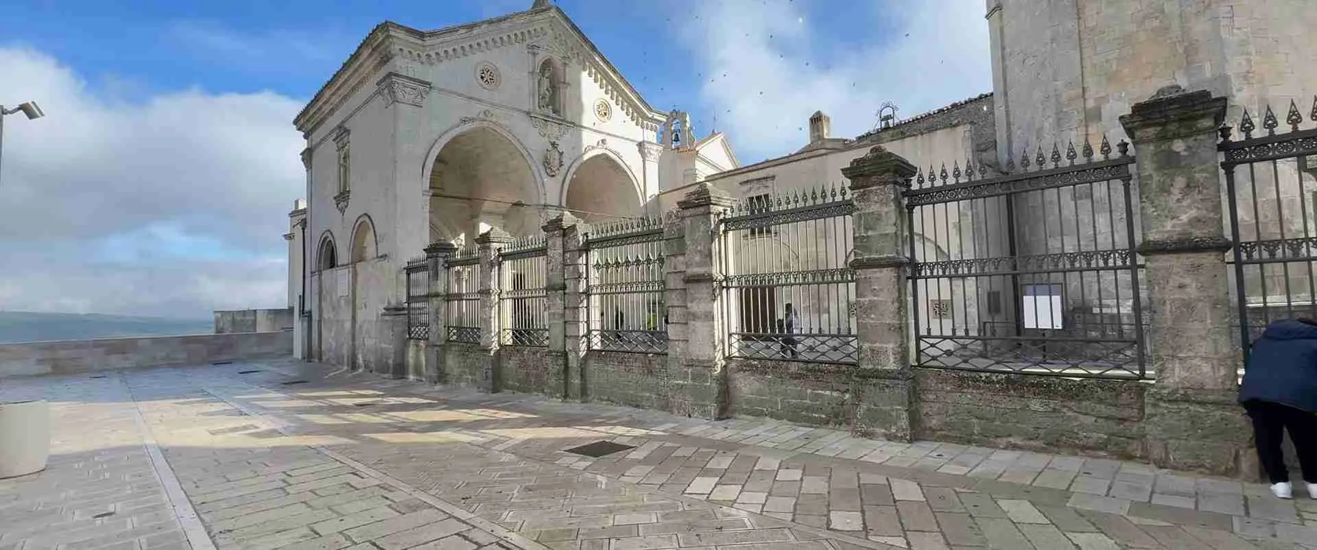
The Sanctuary of San Michele Arcangelo is the primary reason Monte Sant’Angelo has drawn pilgrims for over a millennium. The sanctuary is built around a cave — the Grotta dell’Arcangelo — where, according to Christian tradition, the Archangel Michael appeared in the 5th century. The site became one of the principal pilgrimage destinations of medieval Europe, drawing Norman rulers, Crusader knights, and ordinary travellers on the route to the Holy Land. The sanctuary is part of the UNESCO World Heritage serial site “Longobards in Italy: Places of Power (568–774 A.D.),” inscribed in recognition of the site’s role in the Lombard kingdom’s Christianisation and its function as a major node in the early medieval pilgrimage network. Entry to the cave sanctuary is free. According to official visitor information at the site, a marble statue of the Archangel inside the cave dates to 1507 and is attributed to the Renaissance sculptor Andrea Sansovino. The sanctuary’s ZTL affects the streets immediately surrounding it; park in the designated lots on the approach and walk the final 500 metres through the Junno district, Monte Sant’Angelo’s oldest surviving neighbourhood, to reach the cave entrance stairs.
Day 4 covers the return to Manfredonia via the SS89 descent, which takes approximately 45 minutes on the direct route. A 20-minute detour south of Monte Sant’Angelo leads to Pulsano Abbey, a Benedictine monastery founded in the 12th century in a steep gorge in the rock face. More than 24 hermit cells are carved into the cliff walls surrounding the abbey; access is by a narrow single-track road and requires a private vehicle. The abbey is particularly atmospheric in the off-season, when the gorge is quiet and the carved cells can be examined without crowds. This detour is suitable as a morning stop before the drive south, closing the circuit at Manfredonia by early afternoon.
Planning Your Gargano Drive 2026: Route Timing and Essential Logistics
The practical starting point for most international travellers is Foggia, the provincial capital with rail connections to Rome and Naples (approximately 3.5 and 2.5 hours respectively on the main line) and a small airport. From Foggia, Manfredonia is 40 km south on the SS89 — approximately 35 minutes by car or taxi. Car rental agencies operate at Foggia station and at Bari Karol Wojtyła Airport (approximately 150 km to the south), which has wider international connections and a broader rental fleet. Picking up a car in Bari and returning it in Foggia (one-way rental) is an option some operators offer, though drop fees apply; confirm this before booking.
The ideal circuit direction for visitors arriving from Manfredonia or Foggia is the clockwise route described in this guide: south coast first (SP53 northbound from Mattinata to Vieste), then north coast (SP52 northbound from Vieste to Peschici), then interior (SS89 to Foresta Umbra and Monte Sant’Angelo), then return to Manfredonia. This order has three structural advantages: you arrive at Vieste at end of Day 1 when the coastal road is already behind you; you have the forest and mountain stages in the middle of the trip when you know the car’s handling characteristics; and the return to Manfredonia on Day 4 follows descending terrain and familiar road types. Anticlockwise (starting inland and ending on the coast) is equally valid for arrivals from the north.
Fuel logistics require specific planning. Mattinata has a fuel station near the northern exit of the town that is the last before Vieste on the coastal road — fill the tank here before taking the SP53 section. In Vieste itself, stations are concentrated near the northern entry road to the town. The SP52 between Vieste and Peschici has no fuel supply; Peschici has a station near the main car park approach. Between Vico del Gargano and Foresta Umbra on SS89, there is no fuel infrastructure. Monte Sant’Angelo has one fuel station on the southern approach road. Plan fuel fill-ups at each major town before departing onto the coastal or forest road segments.
Navigation apps work reliably on the main SP52, SP53, and SS89 roads, but signal becomes patchy on the Foresta Umbra plateau and disappears in many areas inside the forest. Download the relevant map tiles for offline use — Google Maps, OsmAnd, or ViaMichelin all support this — before leaving Peschici or Vico del Gargano. OsmAnd provides the most detailed trail data for Foresta Umbra and is the recommended app for the forest day. For the ZTL boundaries in Monte Sant’Angelo, verify the current restricted zone perimeter on the comune’s official website before arrival; ZTL cameras impose automatic fines payable within 60 days.
The circuit is accessible in a standard compact car throughout, but road surface quality varies. The SP53 coastal road is well-maintained — described by touring guides as having a good road surface — but narrow. The SP52 coastal road is in similar condition. The SP52 Bis through the forest has been resurfaced on the major sections but can carry surface debris (leaf fall, small rockfall) after heavy rain. The SS89 internal approach has variable surface quality; the section near Vico del Gargano is reliably good, while some secondary turns toward the forest may have cracked tarmac. A compact diesel handles all surfaces with confidence; a low-clearance sports car is inadvisable on the forest approach roads in wet conditions.
The best time to visit for a driving-focused circuit is May–June or September–October. In May, Foresta Umbra’s orchids are in bloom and the beech canopy is at full leaf before summer heat arrives. In October, the forest colour change produces reds and golds across the plateau that are visible even from the coastal road looking inland. In both shoulder seasons, the SP53 carries a fraction of its August traffic, parking is straightforward at every stop, and accommodation rates are significantly lower than peak season.
Practical Navigation & Seasonal Access Regulations 2026
Three distinct regulatory systems apply to drivers on the Gargano circuit: the national park’s trail and parking management at Foresta Umbra, the ZTL schemes active in several historic town centres (most relevantly Monte Sant’Angelo, Vieste’s old quarter, and Peschici’s cliff approach), and the seasonal weather-based requirement for winter tyres on high-altitude roads. Understanding each system before departure prevents the two most common driver errors on the circuit: inadvertent ZTL entry with an automatic fine, and arriving at a forest trailhead to find the car park full with no fallback plan.
Shuttle Options and Trailhead Parking Systems in High Season
Foresta Umbra has a primary car park adjacent to the visitor centre at the Baracconi locality, accessible from the SP52 Bis. This car park is free and serves as the staging point for the majority of marked trails. In high season — particularly on weekends in July and August — the car park fills by mid-morning. The overflow option is to park along the forest road approach where permitted verge space exists, though this is limited and demands care not to block passing traffic on the narrow SP52 Bis. The most reliable strategy for high-season visitors is to arrive before 8:30 AM, which consistently secures a space at the main car park.
A reservation-only shuttle service from Vieste operates on Wednesday mornings in summer, connecting the coast to the forest for participants in guided trekking or e-bike experiences. This service is not a general access shuttle — it does not replace car access, and independent visitors cannot board it. A second free shuttle service, also reservation-only, connects Mattinata, Monte Sant’Angelo, and Vieste to the forest for participants in the Foresta Umbra e-bike tour programme specifically. For all other visitors, the car is the access mechanism and the primary car park is the destination.
In August, public bus services from several Gargano towns — including Foggia, San Severo, Apricena, Sannicandro Garganico, Rodi Garganico, and Vico del Gargano — connect to Foresta Umbra. These services operate on seasonal timetables that change year to year; check the current schedule with the Gargano National Park visitor information office or the Puglia regional transport authority before planning a car-free day using this connection.
For Monte Sant’Angelo, parking management is more formal. The town’s historic centre is a full ZTL — no vehicles without explicit authorisation may enter, and cameras enforce this automatically around the clock. The recommended car parks for visitors are Parcheggio Via Carlo d’Angiò, which is signposted on the main approach road and sits outside the ZTL boundary, and the Zona Castello lots, which are closer to the sanctuary but fill faster. Both lots are paid (rates are low by Italian city standards) and involve a 5–10 minute walk to the sanctuary entrance. The SITA Sud bus from Manfredonia reaches Monte Sant’Angelo in approximately 40 minutes along the mountain road and deposits passengers at the town entrance; this is a practical alternative to driving if you are basing yourself in Manfredonia and want to make a day visit rather than overnight.
Vieste applies a ZTL to its old town headland (the medieval quarter above the seafront). Day visitors parking in the coastal car parks below the headland are unaffected, but drivers whose accommodation is inside the old town area need to request entry authorisation from the hotel before arrival — most hotels within the ZTL coordinate this routinely. Peschici applies parking restrictions on its cliff approach road in summer; use the signed car parks at the base of the cliff and walk up.
Vehicle Width Constraints and Elevation Drops Across SP52 Highway
The SP52 corridor encompasses two distinct sections with different road characters: the coastal branch running from Peschici south to Vieste (approximately 26 km along the cliff face), and the inland SP52 Bis branch that turns off near Vieste’s Scialmarino Bay and climbs into the Foresta Umbra plateau. Both sections carry the SP52 provincial road designation, but their geometry and the demands they make on drivers differ significantly.
The SP52 coastal section runs at relatively consistent altitude above the sea, with lateral bends through cliff-top vegetation and occasional passages where the road narrows to effective single-lane width as the limestone face on one side and the crash barrier on the other compress the available space. No published vehicle width restriction applies to this section, but in practice, a vehicle wider than approximately 2 metres requires slowing to a near-stop when meeting oncoming traffic in the narrowest passages. This is the standard European rural road constraint — it is not posted, it is simply a physical reality. Drivers of campervans, minibuses, and full-size SUVs should plan to make this drive in early morning or late afternoon to minimise encounters with oncoming tourist coaches, which are the most problematic opposing vehicles at narrow bend points.
The SP52 Bis is a categorically different road. Starting near sea level at Scialmarino Bay, it climbs to the Foresta Umbra plateau at approximately 800 metres — a gain of 800 metres over a road distance of roughly 9 kilometres. The gradient is consistent and the road surface well-maintained, but the combination of elevation gain, dense beech canopy (which creates shadow even on sunny days), and a road that frequently narrows through close-set tree trunks means drivers encounter a continuous sequence of curves with no long sight-lines. The SP52 Bis is described by cycling guides as “cutting through the forest giving us an extraordinary spectacle from the first kilometre” — which accurately conveys that the road passes close to the forest itself, not through clearings. At the lower altitudes, the road gains rapidly and drivers unaccustomed to steep mountain roads may find the gradient more persistent than expected. On the descent from the plateau toward Monte Sant’Angelo, the road via the coastal approach (the provincial road from the hamlet of Macchia) presents tight switchbacks over a sustained 10 km descent — the equivalent of a classified mountain cycling stage in reverse, requiring engine braking throughout rather than constant brake application.
The elevation change between the coast at Vieste and the Foresta Umbra visitor centre at the Baracconi locality is approximately 750–800 metres. Drivers should confirm their car’s engine braking performance before beginning the descent, particularly on a fully loaded vehicle after a long coastal day. The road is well-maintained and the descent is manageable in a compact car; the risk is not the road surface but driver fatigue on a long uphill section with no flat recovery intervals. Budget an unhurried 25–30 minutes for the climb and a similarly paced 20 minutes for the descent to the coast side, with a pause at the first clear viewpoint to allow any following traffic to pass.
Where to Stay and Refuel Along the 2026 Gargano Circuit
The circuit’s accommodation options are most dense at Vieste and most limited at Monte Sant’Angelo; everywhere else on the route sits between these extremes. Booking in July and August requires advance reservation — minimum two weeks, and ideally four to six weeks for Vieste specifically, which hosts over two million visitors annually and runs at full capacity from mid-July through the last week of August.
Manfredonia, the gateway city, has a functional range of mid-range and budget hotels clustered near the port and along the main approach roads. It is not a tourism destination in the same sense as the cliff towns further north, but it is practical, affordable, and connected to the SS89 for the Monte Sant’Angelo ascent. Budget rooms in Manfredonia’s three-star hotels run €65–85 per night in peak season; off-season rates fall to €45–60. The city’s fish market and port district provide reliable, unpretentious restaurant options at prices significantly below what you will encounter in Vieste.
Mattinata offers a different accommodation character: the town sits in an agricultural valley and hosts a number of agriturismos — working farm estates offering rooms and meals — set among olive groves and orchards on the approaches to the SP53 cliff road. These provide a quieter alternative to the beach resort atmosphere of Vieste, with on-site dinners that prioritise local Gargano products: caciocavallo (a firm, aged stretched-curd cheese produced in this part of Puglia), homegrown olive oil, and pasta with vegetables from the estate’s kitchen garden. Budget agriturismo rooms here run €70–90 per room in peak season.
Vieste carries the widest accommodation range on the circuit: budget guesthouses and family B&Bs in the back streets of the old town at €60–80 per room; mid-range hotels with sea-view terraces at €120–160; and a small number of boutique cliff hotels at €200–280. The hotels immediately on the seafront charge a premium for position; the streets behind the old town produce better value with only a short walk to the cliff edge. Self-catering apartments have proliferated significantly in recent years and can represent good value for a group of four spending multiple nights.
Peschici is smaller and less commercially developed than Vieste, which makes it more pleasant to walk through and harder to book in August. The cliff-top historic centre has a handful of small hotels and B&Bs; larger resort properties sit in the bays immediately north and south of the town. The accommodation around Zagare Bay, about 15 km south of Peschici toward Vieste, includes Hotel Baia delle Zagare — one of the few hotels in Italy positioned directly above its private sea-stack bay with a lift down to the water. Prices here reflect the position.
Monte Sant’Angelo has fewer options than its size might suggest. The town’s atmosphere is shaped by pilgrimage rather than tourism, and the accommodation stock reflects this: small family pensions, basic guesthouses, and a handful of hotels in the streets around the sanctuary. This is not a weakness — the experience of arriving at dusk when the pilgrims have departed and the town quietens is something that no coastal resort can match — but it means booking in advance is essential even outside peak months. Expect to pay €55–80 per room for basic accommodation and €100–130 for the better-positioned properties with views across the Tavoliere delle Puglie.
Fuel supply logistics, to revisit: fill at Mattinata before SP53; fill at Vieste before SP52; fill at Peschici or Vico del Gargano before the SS89 interior; fill at Monte Sant’Angelo before the descent. Do not assume that a small town along the coast or in the forest will have an open service station — many rural stations in this part of Puglia are closed on Sunday afternoons and during the midday riposo between approximately 13:00 and 16:00.
Budget for the Gargano Road Trip 2026
The Gargano road trip sits at the more affordable end of the Italian self-drive spectrum. Southern Puglia consistently undercuts northern Italian holiday destinations by 25–40 percent on accommodation and restaurants, and the national park setting keeps most of the circuit’s natural attractions free to enter. The main variable costs are accommodation standard and appetite for seafood restaurants — the Adriatic coastline brings exceptional local fish to even the most modest Gargano trattoria, and the temptation to spend on the fish-based menu is hard to resist.
Budget travellers sharing a room in a family B&B or agriturismo spend €32–43 per person for accommodation, €12–18 for a simple lunch of orecchiette pasta or a tramezzino at a bar, €22–32 for dinner at a local trattoria with house wine, €8–15 for fuel share and parking across the day, and €5–10 for minor attractions such as a guided trabucchi visit or a boat-tour ticket. Daily total for budget travellers: €80–120 per person, two sharing. For a five-day circuit including a shared economy car rental for five days, the total per person runs €470–700.
Mid-range travellers sharing a three-star hotel room spend €55–80 per person for accommodation, €18–28 for lunch at a restaurant with a view, €35–50 for a full dinner with a bottle of local Primitivo di Manduria or Nero di Troia, €12–22 for fuel and parking, and €15–30 for a boat excursion or a half-day guided forest walk. Daily total for mid-range travellers: €135–210 per person, two sharing. Five-day circuit total including a shared mid-range car rental: €785–1,225 per person.
Luxury travellers in boutique masserias and sea-facing boutique hotels pay €110–160 per person for accommodation share, €35–55 for lunch, €70–95 for a full dinner at one of the better restaurants in Vieste or Peschici, €18–30 for fuel and premium parking, and €50–80 per day for private boat experiences, private guided forest excursions, and organised trabucchi experiences. Daily total for luxury travellers: €285–420 per person, two sharing. Five-day circuit total including a shared premium vehicle rental: €1,600–2,375 per person.
Car rental is the single largest predictable cost that varies independent of daily decisions. An economy compact car for five days rented from Foggia or Bari costs approximately €140–200 total before extras; shared between two, this adds €70–100 per person to the circuit total. A mid-range car runs €220–350 total (€110–175 per person). A premium vehicle or SUV runs €350–550 total (€175–275 per person). Full coverage insurance — always recommended in Puglia, where road surfaces can be irregular and the theft risk from parked cars is above the Italian average — adds approximately €15–25 per day to the base rental cost. Book early for July–August; the Foggia rental fleet is small and compact cars sell out.
Seasonal price variation on the Gargano is pronounced. Accommodation rates in Vieste in the last two weeks of August are typically double the same room in September; a mid-range room that costs €120 in July commands €180–220 in the first two weeks of August and drops to €90–100 in October. Restaurant prices are more stable, but the most popular seaside terraces charge a coperto (cover charge) of €2–5 per person that applies regardless of what you order and that budget planning should account for.
Where to save money: carry water and snacks for the coastal road days rather than buying at the handful of very expensive cliff-side kiosks. Picnic at Foresta Umbra, where several designated tables are free and the setting is exceptional. Visit Monte Sant’Angelo on a weekday, when parking is slightly easier and the sanctuary is quieter. Eat lunch as the main meal (pranzo) at local restaurants rather than dinner — you access the same kitchen and wine list at 20–30 percent lower prices in most Gargano establishments. Avoid the promenade restaurants in Vieste’s old town tourist core in July and August; walk two streets inland for the same seafood at half the cover-charge pressure.
Road Safety, Emergency Contacts and Navigation Apps 2026
The single emergency number for Italy is 112, which connects to the integrated emergency service and transfers calls to police, ambulance, or fire response as needed. English is spoken at 112 call centres, though response quality varies; having your GPS coordinates available (visible in the navigation app) significantly speeds roadside assistance or medical response in remote areas. The Gargano’s national park interior and cliff coast sections mean that many incidents occur in areas where a verbal address is impossible — coordinates are the functional equivalent.
The Carabinieri (military police) station for the Vieste area is located in the town centre and handles road incidents, theft reports, and ZTL fine disputes. For incidents in the Gargano National Park territory, the park authority’s visitor centre at Foresta Umbra maintains a contact number posted at the main car park. Mountain rescue on the Gargano plateau falls under the jurisdiction of the CAI (Club Alpino Italiano — Italian Alpine Club) Puglia section; for trail emergencies above 500 metres, the 112 dispatcher will coordinate this response.
Night driving on the Gargano circuit deserves specific attention. The SP53 and SP52 coastal roads have no street lighting outside town boundaries, and the crash barriers between road edge and cliff drop are intermittent. Driving these sections in darkness is not recommended unless you are familiar with the road from daylight driving. The Monte Sant’Angelo switchback descent is particularly problematic at night without a detailed knowledge of the bend sequence. Plan day stages to arrive at overnight destinations before sunset; the days are long enough in summer that this is straightforward, and the coastal road light at golden hour is one of the photographic rewards of the circuit.
Winter tyre requirements apply to roads in higher-altitude areas of the Gargano from 15 November to 15 April under Italian law. This requirement covers the Monte Sant’Angelo approach roads and the SP52 Bis forest road, both of which can carry ice in cold spells even when conditions at sea level are mild. Standard rental cars collected in Puglia do not carry winter tyres by default — verify with the rental agency whether the vehicle is equipped if you are driving the circuit in late autumn or early spring. Snow chains are an alternative to winter tyres and are legally acceptable if carried in the car and fitted when conditions require; they can be rented cheaply from hardware stores in Foggia or Manfredonia.
Car security on the Gargano circuit follows the standard Puglia precaution: do not leave valuables visible inside the car at any point, but especially at the beach laybys along the SP53, where parked cars can sit unattended for hours while drivers are on the beach. A dashcam is a practical addition for incident documentation. Luggage in the boot rather than on the back seat removes the primary incentive for opportunistic break-ins. These are not uniquely Gargano risks — they apply across Puglia — but the coastal laybys on the SP53 are among the locations where the risk is somewhat elevated by the concentration of tourist vehicles.
Recommended navigation apps for the 2026 circuit: OsmAnd (the best offline coverage in the forest interior, with trail data), Google Maps (for real-time traffic on the coastal roads approaching Vieste in summer), and ViaMichelin (for the most reliable ZTL boundary data, which the app updates more frequently than Google in the Italian market). None of these should be relied upon exclusively inside the forest — download the Gargano National Park’s own PDF trail maps from the official park website (parcogargano.it) as a non-battery-dependent backup. A physical map of the Gargano road network (available at bookshops in Foggia and the tourist information offices in Vieste and Peschici) adds negligible weight and provides a navigational fallback that no dead battery can remove.
Frequently Asked Questions
How long does the full Gargano circuit take to drive in 2026, and can it be done in less than four days?
The four-day structure described in this guide is the minimum that does the circuit justice without feeling rushed. The total driving distance of approximately 210 km (including the Foresta Umbra loop and the Monte Sant’Angelo descent) can technically be covered in two days by an experienced driver, but the SP53 coastal road requires slow, attentive driving and rewards stopping at viewpoints and bays; the forest day rewards spending three or four hours on trails rather than driving straight through. Three days is feasible for return visitors who know the roads; four days is the right allocation for first-timers.
Is the Gargano circuit suitable for motorhomes and campervans in 2026?
Motorhomes and campervans can complete the circuit but will find the SP52 Bis forest road and the SP53 cliff sections genuinely difficult in peak season. The SP52 Bis narrows substantially through the beech canopy, and the turns require a large vehicle to pull out wide — possible but stressful when traffic is present. The switchbacks on the Monte Sant’Angelo descent via the coastal approach road are similarly challenging for long-wheelbase vehicles. If you are travelling in a motorhome, consider using the wider SS272 approach to Monte Sant’Angelo from the north, avoid the coastal cliff sections in July and August midday traffic, and check your vehicle height against the limited clearance under certain cliff overhangs on the SP52 coastal section.
What are the key beaches accessible from the SP53 for a 2026 coastal driving day?
The most accessible beach stops on the SP53 northbound from Mattinata to Vieste are Mattinatella Beach (immediately north of Mattinata, with a resort lido and seasonal restaurants), the Zagare Bay overlook (where the sea stacks are viewed from the clifftop — beach access requires a boat or a long descent path), and Vignanotica Bay (a remote shingle cove reached by a 5 km trail from the SP53 trailhead parking, or via the Vignanotica Beach campsite access road). The seasonal shuttle from the campsite makes Vignanotica Bay accessible without the hike on the days it operates. All laybys fill by 9 AM in peak summer.
Can I visit Foresta Umbra as a day trip from Vieste without a car in 2026?
Car-free access to Foresta Umbra from Vieste requires either the reservation-only Wednesday morning shuttle (which is designed for guided tour participants, not independent visitors), the August public bus service (which needs schedule verification each season), or a taxi. In practice, the taxi option is the most reliable for independent visitors who want a car-free day in the forest: a round-trip taxi from Vieste to the Foresta Umbra visitor centre costs approximately €50–70 depending on the driver and the season. Book through your accommodation the evening before, as there are limited taxi operators and high demand in peak season. A guided tour by e-bike, for which the reservation-only shuttle is provided, removes the transport problem entirely.
What is the Sanctuary of San Michele Arcangelo and why does it matter for the Gargano circuit in 2026?
The Sanctuary of San Michele Arcangelo at Monte Sant’Angelo is a UNESCO World Heritage Site — part of the serial inscription “Longobards in Italy: Places of Power” — and one of the oldest uninterruptedly functioning Christian sanctuaries in Western Europe. The cave sanctuary contains the sacred grotto where, according to Christian tradition, the Archangel Michael appeared in the late 5th century. It was a major node on the medieval pilgrimage route to Jerusalem, visited by Lombard kings, Norman dukes, and ordinary medieval travellers on their way south to the ports of embarkation. Today the sanctuary is free to enter and manages a steady flow of both religious pilgrims and heritage visitors. The cave is cool, dim, and acoustically distinctive — entry without advance reservation is the norm except on major feast days, when it can be very crowded. Arrive before 9 AM for the best experience.
Are the trabucchi still in active use on the Gargano coast in 2026?
Several trabucchi along the Peschici–Vieste coastal stretch remain in active fishing use. The confirmed operational fishing platforms include Trabucco Isola della Chianca, Trabucco Molinella, Trabucco Punta Lunga, Trabucco San Lorenzo, and Trabucco Tufara/Torre Porticello, though the operational status of individual structures changes with family circumstances and weather damage from winter storms. The association La Rinascita dei Trabucchi storico coordinates guided experiences on working platforms in season; their website or the Gargano National Park visitor information can confirm current status. Many other trabucchi have been converted to seasonal restaurants — the Trabucco San Lorenzo position, built on a headland with views along the cliff face, is among the most striking dining locations on the coast.
What is the ZTL situation in Vieste and how does it affect visitors staying in the old town in 2026?
Vieste’s ZTL covers the medieval headland quarter of the old town. Visitors staying in hotels or accommodation within the ZTL area can request temporary access permission through their accommodation — most properties inside the zone handle this routinely and will provide you with the relevant information at booking or check-in. Day visitors and those staying outside the ZTL park in the large paid car parks at the southern and northern seafront approaches and walk in; the furthest car park to the old town entrance is approximately 10 minutes on foot. The ZTL cameras in Vieste enforce restrictions automatically; receiving a fine from an inadvertent ZTL entry generates a penalty notice sent to your rental agency, which passes it to you with an administration fee added. Contact your accommodation before arrival if your check-in time falls outside normal hours to clarify the ZTL access procedure for your vehicle.
What is the driving time from Foggia to Vieste and what route should I take in 2026?
From Foggia, the fastest route to Vieste is via the SS693 Gargano superstrada to Vico del Gargano and then the SS89 south to Vieste — approximately 110 km and 1 hour 45 minutes in normal traffic, longer on summer weekends when the SS89 approach to Vieste backs up for several kilometres. The scenic alternative — longer in time but rewarding for those beginning the circuit immediately on arrival — is to exit at Mattinata and take the SP53 coastal road northbound directly into Vieste, adding 30–45 minutes but delivering the best of the southern coastal road as the first driving experience of the trip. This approach has the practical benefit of placing the SP53 section at the start of Day 1 with fresh concentration and full daylight.
How should I handle the Monte Sant’Angelo descent back toward Manfredonia on the final day of the Gargano circuit in 2026?
The descent from Monte Sant’Angelo to the Manfredonia plain is best handled with engine braking and a relaxed pace. Use a lower gear — second or third in a manual car — for the steepest switchback sections, particularly on the coastal approach road via Macchia, which descends approximately 800 metres over roughly 10 km with sustained gradient and tight turns throughout. Avoid riding the brakes continuously, as this can cause overheating on long descents; instead, use engine braking between brake applications. The road surface on this descent is well-maintained but becomes greasy in wet conditions, and the tunnel of vegetation on either side of the road limits how far ahead you can see. Allow 25–30 minutes for the full descent to the coast road, and stop at one of the two or three laybys with Gulf of Manfredonia views — the panorama across the Tavoliere delle Puglie plains is the clearest on the entire circuit.
Is the Gargano circuit accessible year-round, or are there months when roads are closed in 2026?
The circuit is accessible year-round; no road sections are officially closed in normal winter conditions. However, the SP52 Bis (Foresta Umbra) and the Monte Sant’Angelo approach roads carry mandatory winter tyre or snow chain requirements from 15 November to 15 April. These roads do experience occasional snow and ice during cold spells — the 800-metre plateau retains frost conditions well after coastal temperatures have risen — and a standard summer rental tyre on an icy switchback road is a serious safety risk. October and May are the optimal shoulder-season months for drivers who want year-round access: roads are dry, traffic is light, the Foresta Umbra and Monte Sant’Angelo accommodation is open at off-season rates, and the coastal light quality is superior to the bleached white of August. November through March is quiet and cold on the plateau, mild on the coast, and completely different from the summer experience — worth the circuit for travellers who prefer empty roads and empty accommodation over beach weather.