Thingvellir National Park: Complete UNESCO World Heritage Guide
Thingvellir National Park stands where two continents meet and Iceland’s democracy was born, offering a rare convergence of geological drama and historical significance unmatched anywhere on Earth. This UNESCO World Heritage Site preserves the assembly grounds of the world’s oldest existing parliament while showcasing the visible separation of the North American and Eurasian tectonic plates. Whether you walk through the Almannagjá rift valley where Viking-age lawmakers once gathered or dive between continents in the crystalline Silfra fissure, Thingvellir delivers experiences found nowhere else on the planet.
Key Takeaways About Thingvellir National Park
- Dual UNESCO Significance: Inscribed in 2004 under cultural criteria III and VI, Thingvellir protects both the archaeological remains of Iceland’s Althing parliament (930-1798) and a dramatic rift valley where continental plates visibly separate at approximately 2 centimeters annually.
- Parliamentary Birthplace: The Althing established at Thingvellir in 930 AD represents one of the world’s first democratic assemblies, where free men gathered annually for two weeks to legislate laws, settle disputes, and conduct the business of governance in an open-air setting framed by towering basalt cliffs.
- Continental Divide Above Sea Level: Iceland remains the only location worldwide where the Mid-Atlantic Ridge emerges above ocean waters, and Thingvellir provides the clearest view of both the North American plate edge (visible as the western cliff face of Almannagjá) and the Eurasian plate edge opposite.
- Golden Circle Centerpiece: As the first or final stop on Iceland’s most traveled tourist route, Thingvellir anchors the Golden Circle alongside Gullfoss waterfall and the Geysir geothermal area, drawing hundreds of thousands of visitors annually to walk between continents and explore Iceland’s founding narrative.
- Unique Diving Between Plates: The Silfra fissure offers the world’s only opportunity to snorkel or dive between tectonic plates in water filtered through underground lava fields for decades, achieving visibility exceeding 100 meters through glacial meltwater originating from Langjökull glacier.
- Living Geological Laboratory: The valley floor has subsided more than 40 meters over the past 9,000 years and continues descending as earthquake activity releases accumulated tensional stress, providing scientists with exceptional evidence of continental drift processes and plate tectonics in action.
People Also Ask About Thingvellir National Park
Why Is Thingvellir a UNESCO World Heritage Site?
Thingvellir earned UNESCO World Heritage designation in 2004 under cultural criteria III and VI for its exceptional testimony to the open-air parliamentary assembly that met annually from 930 AD to 1798. The site preserves the best-remaining archaeological and historical evidence of the Althing, the general assembly established by Iceland’s earliest Norse settlers. Unlike local or regional assemblies found elsewhere in medieval Europe, the Althing represented the entire Icelandic nation and functioned as the country’s de facto capital for two weeks each year. The property includes fragments of approximately 50 booths constructed from turf and stone, the Law Rock (Lögberg) where laws were proclaimed, and the Law Council (Lögrétta) assembly area. The cultural landscape has changed minimally since the 10th century, maintaining integrity and authenticity despite the passage of more than a millennium.
Can You Walk Between Two Continents at Thingvellir?
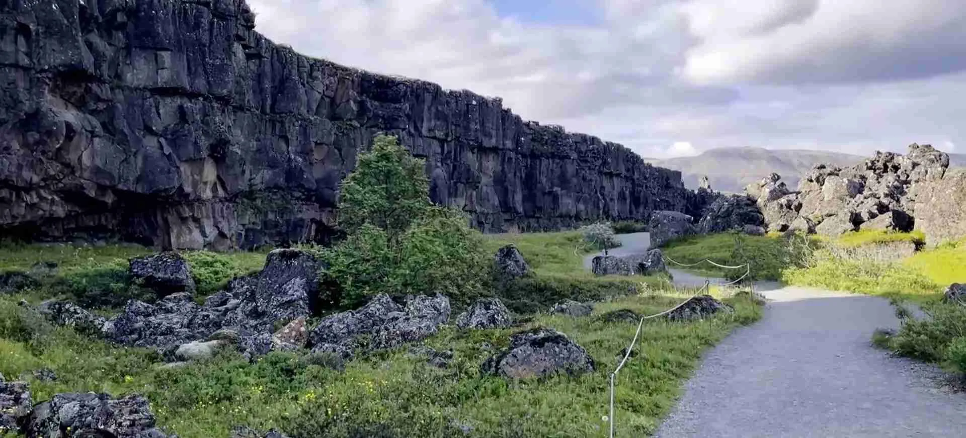
Walking between the North American and Eurasian continental plates constitutes the primary geological experience at Thingvellir National Park. The Almannagjá gorge creates a natural pathway approximately one kilometer in length where visitors walk along the rift valley floor with the edge of North America rising as dramatic basalt cliffs to the west and the Eurasian plate forming the eastern boundary. This rift valley lies within a seven-kilometer-wide graben formed as the plates drift apart at roughly 2 centimeters per year. Iceland represents the only place on Earth where the Mid-Atlantic Ridge emerges above sea level, and Thingvellir provides the most accessible and visually striking location to observe this continental separation. The pathway descends from the Hakið viewing platform through the gorge, passing the Law Rock site and continuing to the valley floor near Lake Thingvallavatn.
What Was the Althing and Why Was It Important?
The Althing (Alþingi in Icelandic) established at Thingvellir around 930 AD represents one of the world’s first parliamentary assemblies and the foundation of Iceland’s national identity. Free men from across Iceland traveled to Thingvellir each summer for a two-week gathering where the Law Speaker (Lögsögumaður) recited laws from memory, disputes were adjudicated, alliances formed, and new legislation enacted. The assembly operated as a covenant among free people rather than subjects of a monarch, establishing principles of law and governance that influenced democratic development across Europe. Sessions took place in the natural amphitheater formed by the Almannagjá and Heiðargjá fault walls, with the Law Rock serving as the speaking platform and approximately 50 temporary booths housing attendees during the gathering. The Althing continued meeting at Thingvellir until 1798, when it relocated to Reykjavík, making this site central to nearly nine centuries of Icelandic legal and political history.
What Geological Processes Created Thingvellir?
Thingvellir occupies a rift valley created by the continuous separation of the North American and Eurasian tectonic plates along the Mid-Atlantic Ridge. The graben (valley formed by parallel faults) sits between the Almannagjá and Heiðargjá faults and is covered with approximately 10,000-year-old basaltic lava flows that originated from craters south of Mount Hrafnabjörg. As the plates drift apart at roughly 2 centimeters annually, tensional stress accumulates over extended periods before releasing through earthquake events that cause the valley floor to subside while the fault edges remain elevated. The total subsidence exceeds 40 meters over the past 9,000 years, with the valley continuing to descend and expand. Glaciation during ice ages profoundly affected local volcanism, creating pillow lavas, hyaloclastite formations, and distinctive landforms called tindars and tuyas through interactions between magma and meltwater. Lake Thingvallavatn formed within this geological setting, fed by underground springs where water filtered through porous lava rock emerges with exceptional clarity.
Extended multi-day tours – 5+ days
Featured Iceland Multi-Day Tour Packages

3 days
Iceland 3-Day Discovery Tour
- ✓ Comprehensive Iceland experience
- ✓ Expert local guides included
- ✓ All accommodation included
- ✓ Transportation provided
5 days
Iceland 5-Day Highlights Experience
- ✓ Comprehensive Iceland experience
- ✓ Expert local guides included
- ✓ All accommodation included
- ✓ Transportation provided
7 days
Iceland 7-Day Cultural Journey
- ✓ Comprehensive Iceland experience
- ✓ Expert local guides included
- ✓ All accommodation included
- ✓ Transportation provided
10 days
Iceland 10-Day Complete Adventure
- ✓ Comprehensive Iceland experience
- ✓ Expert local guides included
- ✓ All accommodation included
- ✓ Transportation provided
Multi-day tour packages powered by TourRadar. Prices and availability subject to change.
Introduction: Where Geology Meets History
Thingvellir National Park occupies a singular position in both Earth sciences and human civilization, representing the only location where visitors can simultaneously witness the forces that shape continents and explore the birthplace of one of the world’s oldest democracies. Designated as Iceland’s first national park in 1930 and inscribed as a UNESCO World Heritage Site in 2004, this protected landscape in southwestern Iceland encompasses approximately 240 square kilometers of rift valleys, fissures, lava fields, and the northern shore of Lake Thingvallavatn, Iceland’s largest natural lake.
The geological significance centers on Thingvellir’s position astride the Mid-Atlantic Ridge, where the North American and Eurasian tectonic plates drift apart at approximately 2 centimeters per year. This continental separation creates a dramatic rift valley visible as sheer basalt cliffs, deep fissures including the renowned Silfra diving site, and a continuously subsiding valley floor that has dropped more than 40 meters over nine millennia. Iceland remains the only place on Earth where this submarine mountain range emerges above ocean waters, and Thingvellir provides the clearest, most accessible view of both plate edges and the active geological processes occurring between them.
The cultural and historical importance proves equally profound. Around 930 AD, Iceland’s early Norse settlers established the Althing at Thingvellir, creating a general assembly where free men from across the island gathered annually for two weeks to proclaim laws, adjudicate disputes, and conduct governance through democratic processes revolutionary for their era. The natural amphitheater formed by the rift valley walls provided an ideal setting for these assemblies, with the Law Rock (Lögberg) serving as a speaking platform and the valley floor accommodating approximately 50 temporary booths where attendees sheltered during proceedings. The Althing continued meeting at Thingvellir until 1798, making this site central to nearly nine centuries of Icelandic parliamentary tradition and national identity formation.
Modern visitors encounter this layered significance through multiple experiences. Walking through the Almannagjá gorge means treading the same ground where Viking-age lawmakers deliberated while simultaneously stepping between two continents. Diving or snorkeling in the Silfra fissure offers underwater views of the continental divide through water filtered over decades through underground lava fields, achieving visibility exceeding 100 meters. Hiking trails connect archaeological sites including the Law Rock, Thingvellir Church, abandoned farm ruins, and Öxarárfoss waterfall, where the Öxará River cascades 13 meters over basalt ledges.
The park’s position as the primary stop on Iceland’s Golden Circle tourist route brings hundreds of thousands of annual visitors to this convergence of natural wonder and human history. Yet despite this accessibility, Thingvellir maintains the authenticity and integrity that earned its UNESCO designation, with the overall cultural landscape remaining remarkably unchanged since the 10th century and management protocols preserving both geological features and archaeological remains for future generations.
UNESCO World Heritage Inscription and Outstanding Universal Value
Thingvellir National Park received UNESCO World Heritage designation in 2004 under cultural criteria III and VI, recognizing its exceptional testimony to early parliamentary governance and its deep historical and symbolic associations for the Icelandic people. The inscription represents Iceland’s first World Heritage Site and remains the only cultural designation among the country’s three UNESCO properties, the others being Surtsey and Vatnajökull National Park, both recognized for natural values.
Criterion III acknowledges Thingvellir as bearing exceptional testimony to a cultural tradition through the best-remaining archaeological and historical evidence of the assembly established by Iceland’s earliest settlers. The physical remains of the Althing and its nearly 900-year persistence at this single location provide unique insights into Viking Age governance systems and the evolution toward modern legal frameworks. The property encompasses the assembly site itself, fragments of approximately 50 booths built from turf and stone, the Law Rock speaking platform, the Law Council assembly area, and the broader cultural landscape including Thingvellir Church, adjacent farm buildings, and remains of agricultural use from the 18th and 19th centuries.
Criterion VI recognizes the site’s direct association with living traditions, ideas, beliefs, and events of outstanding universal significance. The Althing represents a tangible manifestation of Germanic law and governance, documented extensively through Icelandic sagas and the written codification of the Grágás law code. The connection between the Althing, Thingvellir, and concepts of natural law and noble governance strengthened during Iceland’s 19th-century independence movement, when appreciation of landscape values merged with political aspirations. The hinterland surrounding the assembly grounds traditionally served as grazing areas for those attending the Althing, with networks of tracks leading to the assembly site creating a fossilized cultural landscape reflecting a thousand years of farming evolution.
The Statement of Outstanding Universal Value emphasizes how the rift valley’s dramatic cliffs provide a magnificent natural backdrop for the open-air assembly, creating an inseparable relationship between geological setting and human cultural expression. The property includes not only the terrestrial assembly site but also Lake Thingvallavatn, which hosts unique Arctic char populations that evolved into four distinct forms within the same lake over less than 10,000 years, demonstrating exceptional evolutionary processes linked to habitat creation through continental drift.
Authenticity assessments note that the overall cultural landscape has changed minimally since the 10th century, with recent buildings like Thingvellir Church and the adjacent farm respecting traditional architectural styles. At inscription, the property faced authenticity concerns regarding contemporary summer houses along the western shores of Lake Thingvallavatn and conifer plantations within the assembly site. The conifer trees have since been removed, and the Valholl hotel that occupied the inner core burned down in 2009, improving the property’s integrity. Contemporary management focuses on addressing remaining authenticity challenges while preparing for steadily increasing visitor numbers.
Protection mechanisms include the Thingvellir National Park Act of 2004, which enlarged the park from approximately 50 square kilometers to 240 square kilometers, with the expanded area functioning as a buffer zone surrounding the core World Heritage property. Cultural remains within the area receive additional protection under Iceland’s National Heritage Act. The Thingvellir Commission, the same administrative arrangement that has governed the park since 1930, maintains responsibility for safeguarding the natural and historical area while accommodating visitors and implementing recommendations from the World Heritage Committee and its advisory bodies.
Geological Foundations: Iceland’s Tectonic Theater
Thingvellir National Park functions as an open-air geology classroom where the normally hidden processes of plate tectonics manifest as dramatic landscape features accessible to non-specialists. The park sits directly atop the Mid-Atlantic Ridge, the submarine mountain range running down the center of the Atlantic Ocean where new oceanic crust forms as tectonic plates diverge. Iceland owes its very existence to a mantle plume producing twice the volcanic material typical of mid-ocean ridges, causing the submarine ridge to rise above sea level and creating the island nation.
Three tectonic elements converge at Iceland: the North American plate forming the western portion of the island, the Eurasian plate comprising the eastern section, and the micro-tectonic Hreppafleki plate occupying a small area in the southwest. The Mid-Atlantic Ridge runs through Iceland in a northeast-southwest orientation, with the plate boundary zone marked by volcanic eruption belts and parallel fault systems. At Thingvellir, the plates separate through a process called rifting, where tensional forces pull the crust apart rather than the compressional forces that create mountain ranges or the lateral sliding that defines transform boundaries like California’s San Andreas Fault.
The Thingvellir graben (a valley formed between two parallel faults) extends approximately seven kilometers in width, bounded by the Almannagjá fault to the west and the Heiðargjá fault to the east. The valley floor consists primarily of basaltic lava flows approximately 10,000 years old that originated from volcanic craters south of Mount Hrafnabjörg. As the North American and Eurasian plates drift apart at roughly 2 centimeters annually, the valley floor subsides while the fault edges remain elevated, creating the dramatic cliffs and escarpments that define the landscape.
This subsidence occurs episodically rather than continuously. Tensional stress accumulates over extended periods as the plates separate, then releases suddenly through earthquake events that cause abrupt vertical and horizontal ground movement. The total subsidence at Thingvellir exceeds 40 meters over the past 9,000 years, with measurements indicating the valley floor has dropped 3-4 meters since the Althing was founded and will continue descending at irregular intervals. The 2000 earthquake sequence in southern Iceland, though centered 40-50 kilometers southeast of Thingvellir, caused rocks to fall from ravine walls and water in the Flosagjá fissure to become turbid from sediment disturbance, demonstrating the ongoing nature of these geological processes.
Volcanic activity plays an integral role in the region’s geological evolution. During glacial periods, interactions between magma and ice produced distinctive landforms including pillow lavas (formed when lava erupts underwater or beneath ice), hyaloclastite formations (volcanic glass fragments created by rapid cooling), and tindars or tuyas (steep-sided, flat-topped mountains built through subglacial eruptions). These features, exceedingly rare elsewhere but common around Thingvellir and throughout Iceland, provide evidence of how glaciation profoundly influenced regional volcanism.
The fissures and ground cracks at Thingvellir provide exceptionally clear evidence for continental drift theory and plate tectonics, comparable in scientific importance to East Africa’s Rift Valley System. The major fissures include Almannagjá (the largest and most accessible), Flosagjá (where coins thrown by tourists lie visible on the fissure floor through crystal-clear water), and Silfra (the water-filled fissure famous for diving and snorkeling). These cracks formed as the diverging plates created openings in the brittle surface crust, with some subsequently filling with water while others remain dry passages through the volcanic rock.
Lake Thingvallavatn occupies a critical position in this geological setting. As Iceland’s largest natural lake, Thingvallavatn formed within a northeast-southwest elongated graben created by the western branch of Iceland’s rift zone. The lake’s shores and depths have been shaped over millennia by volcanic landforms, ancient lava fields, and the subsiding valley floor. Water enters the lake through underground springs where precipitation and glacial meltwater filtered through porous lava rock and hyaloclastite formations emerge with exceptional purity. The lake’s ecological environment, particularly the presence of four distinct Arctic char morphs that evolved within the same water body over less than 10,000 years, directly links to habitat creation through tectonic processes.
Historical Assembly Site: The Althing and Iceland’s Democratic Foundations
The establishment of the Althing at Thingvellir around 930 AD represents a foundational moment in both Icelandic national identity and the broader history of democratic governance. Iceland’s early settlers, predominantly Norwegian Vikings fleeing political consolidation under King Harald Fairhair, created a society without monarchy or centralized authority. Instead, they developed a system where regional chieftains (goðar) held both religious and political authority, and disputes were resolved through assemblies based on Germanic legal traditions.
The decision to create a general assembly for all Iceland arose from the need for a unified legal framework and dispute resolution mechanism that transcended local assemblies. Around 930, leaders selected Thingvellir as the assembly site, likely chosen for its central location accessible from settlements across Iceland, abundant grazing land to support attendees’ horses, fresh water from the Öxará River and Lake Thingvallavatn, and the dramatic natural amphitheater formed by the rift valley walls that could accommodate large gatherings while providing acoustic advantages for speakers.
The Althing operated as an annual two-week gathering typically held in late June or early July, when Iceland’s brief summer provided optimal travel conditions and adequate daylight for proceedings. Free men from across Iceland traveled to Thingvellir with their households, supporters, and livestock, establishing temporary encampments in the approximately 50 booth sites whose turf and stone foundations remain archaeologically visible. These booths provided shelter during the assembly, with canvas or turf roofs added each year and removed at the gathering’s conclusion.
The Law Rock (Lögberg) functioned as the assembly’s focal point, a natural elevated platform where the Law Speaker proclaimed laws and announced decisions. The Law Speaker held office for three-year terms and bore responsibility for memorizing and publicly reciting Iceland’s entire legal code, a remarkable feat given the complexity of Germanic customary law. The recitation took three years to complete, with one-third delivered at each summer assembly. This oral legal tradition continued until the 12th century, when laws were first committed to writing in the Grágás code.
The Law Council (Lögrétta) comprised chieftains and bishops who deliberated on new legislation and judicial matters. Initially consisting of 39 chieftaincies, the number later expanded to 48. The council met in a specially designated area within the assembly grounds, conducting both legislative and judicial functions. Criminal cases, civil disputes, and matters of national importance all fell within the Althing’s jurisdiction, with decisions reached through discussion, negotiation, and when necessary, majority vote among the assembled chieftains.
Beyond formal legal proceedings, the Althing served crucial social, economic, and cultural functions. Marriages were arranged, trade conducted, alliances formed, and news exchanged among communities separated by difficult terrain and harsh climate throughout the year. Sporting competitions, storytelling, and religious observances created a festival atmosphere alongside the serious business of governance. The gathering reinforced social bonds and national identity among people who lacked a monarch, capital city, or other unifying institutions beyond the law itself.
The Althing’s significance extended beyond Iceland’s borders, influencing parliamentary development across Scandinavia and serving as a model for other Germanic assemblies. The institution represents an early manifestation of principles including rule of law, public legal proceedings, representative governance, and the concept of laws as agreements among free people rather than decrees from sovereign authority. These ideas, though common in modern democracies, were revolutionary in 10th-century Europe, where most governance centered on monarchical or ecclesiastical power.
Christianity’s adoption in 1000 AD demonstrates the Althing’s authority and the sophisticated negotiation skills it fostered. When religious tensions between pagan and Christian Icelanders threatened civil war, the Law Speaker adjudicated the dispute, ultimately declaring Christianity the official religion while allowing private pagan worship to continue. This peaceful resolution of a potentially devastating conflict showcases the assembly’s effectiveness as a dispute resolution mechanism.
The Althing continued meeting at Thingvellir until 1798, when Danish authorities dissolved the assembly as part of political reforms. The institution was reconstituted in Reykjavík in 1844 as an advisory body, gradually regaining legislative authority as Iceland moved toward independence. Today’s Icelandic parliament retains the name Althing and traces its lineage directly to the assembly established at Thingvellir more than eleven centuries ago, making it among the world’s oldest continuously operating legislative bodies despite the interruption.
Almannagjá Gorge: Walking the Continental Divide
Almannagjá (meaning “Everyman’s Gorge”) constitutes Thingvellir’s most accessible and visually dramatic geological feature, offering visitors the unique experience of walking through a rift valley created by separating tectonic plates. This massive fissure extends approximately 7.7 kilometers in length, with depths reaching 40 meters and widths varying from narrow passages to broader sections where the gorge floor accommodates walking paths, archaeological sites, and seasonal streams.
The gorge formed through the gradual separation of the North American and Eurasian plates, with the eastern wall representing the edge of the Eurasian plate and the western wall marking the North American plate boundary. As the plates diverge at approximately 2 centimeters annually, the valley between them widens while periodic earthquakes cause vertical displacement, with the valley floor subsiding relative to the elevated fault edges. The resulting escarpment rises as an imposing basalt cliff visible from the Hakið viewing platform, the primary entry point for most visitors.
Entering Almannagjá from Hakið involves descending a constructed pathway that zigzags down the cliff face, providing increasingly intimate views of the columnar basalt formations composing the rock wall. Basalt columns form when lava flows cool and contract, creating hexagonal fracture patterns that give the cliff face a distinctive architectural appearance. The pathway eventually reaches the gorge floor, where visitors walk along a maintained trail with the North American plate towering to the west and older, collapsed sections of the same plate forming walls to the east.
The walking route through Almannagjá passes several historically and archaeologically significant locations. The Law Rock (Lögberg) site, marked by an Icelandic flag, occupies a position along the eastern wall where the natural acoustics allowed the Law Speaker’s voice to carry across the assembled crowd. While the exact location of the Law Rock remains debated among scholars, the flagged site represents the traditional identification and serves as a focal point for understanding the assembly’s spatial organization.
Further along the gorge, the Öxará River crosses through a channel carved over centuries, creating small waterfalls and pools where the water tumbles over lava ledges. The river, diverted from its original course in the 9th century to provide water for assembly attendees, flows through the gorge before continuing to Öxarárfoss waterfall downstream. The intersection of water, basalt formations, and the dramatic verticality of the fault walls creates constantly changing visual compositions as light, weather, and seasonal conditions transform the gorge’s appearance.
The gorge floor itself provides evidence of the ongoing geological processes. New fissures periodically open as tensional stress releases through earthquake events, while existing cracks widen incrementally with each year’s plate separation. Loose rocks fallen from the walls during seismic activity scatter across the pathway, with fresh falls distinguishable from weathered stones that have rested for decades or centuries. The sense of walking through an active geological process rather than merely observing ancient formations distinguishes Almannagjá from more static geological sites.
Vegetation within the gorge reflects the harsh environmental conditions and limited soil development. Mosses and lichens colonize rock surfaces, while hardy grasses and low-growing shrubs establish in soil pockets where organic matter has accumulated. The microclimate within the gorge differs from the exposed surrounding landscape, with reduced wind exposure but also limited sunlight due to the depth and orientation of the walls, creating ecological niches distinct from the surrounding environment.
The gorge trail extends approximately one kilometer from the Hakið entry point to the valley floor near Lake Thingvallavatn, though hikers can continue exploring longer routes that connect to other park features including Öxarárfoss waterfall, Thingvellir Church, and various abandoned farm sites. The maintained pathway allows access for visitors with varying mobility levels, though the initial descent requires managing stairs and moderate elevation change.
Silfra Fissure: Diving Between Continents
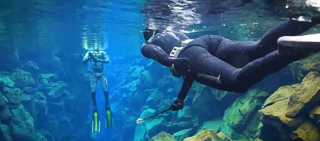
Silfra fissure ranks among the world’s most celebrated dive sites, offering the unique experience of swimming or snorkeling between tectonic plates in water so clear that visibility regularly exceeds 100 meters. This water-filled crack in the Earth’s crust formed during a 1789 earthquake event as the separating North American and Eurasian plates created an opening that subsequently filled with glacial meltwater filtered over decades through underground lava fields.
The water entering Silfra originates from Langjökull glacier, Iceland’s second-largest ice cap located approximately 50 kilometers to the northeast. Precipitation and glacial meltwater percolate through the porous basaltic lava and hyaloclastite formations that compose the subsurface geology, undergoing natural filtration that removes particulates and sediments while maintaining near-freezing temperatures year-round. This filtration process takes approximately 30-100 years, meaning the water divers swim through today fell as snow or rain decades ago.
The exceptional visibility results from this extended filtration combined with minimal biological activity. The water temperature remains between 2-4°C (35-39°F) year-round, too cold to support significant algae growth or aquatic plant life. The absence of particulates, organisms, and dissolved minerals creates optical conditions approaching distilled water, allowing divers to see from one end of the fissure sections to the other. On days with optimal lighting and calm water, visibility can reach 120 meters or more, creating the sensation of flying through air rather than swimming through water.
Silfra consists of four main sections, each offering distinct characteristics and visual experiences. The Silfra Big Crack, the first section encountered, features narrow passages where divers swim between the continental plate walls, literally touching North America with one hand and Eurasia with the other. The crack width varies from less than a meter to several meters, with depths reaching 18-23 meters at the deepest points. The second section, known as Silfra Hall, opens into a wider chamber with a sandy bottom where filtered sunlight creates ethereal blue hues through the water column.
Silfra Cathedral, the third section, represents the dive’s most dramatic space. Here the fissure expands into a vast chamber with towering walls disappearing into darkness on either side. The filtered light penetrating from above creates a cathedral-like atmosphere, with beams of sunlight illuminating suspended particles in otherwise invisible water. The final section, Silfra Lagoon, opens into a shallow area where the fissure connects to Lake Thingvallavatn, with depths of 2-3 meters and a sandy bottom scattered with rocks and minimal vegetation.
Access to Silfra requires participation in organized tours led by certified guides due to the challenging environmental conditions and the need to protect this fragile ecosystem. Divers must possess dry suit certification or have logged at least ten dry suit dives verified by a qualified instructor, as the water temperature makes exposure protection essential. Snorkeling participants face fewer requirements but must be at least 12 years old, able to swim, meet minimum height and weight standards for proper dry suit fitting, and feel comfortable in confined aquatic environments.
The dry suits provided for both diving and snorkeling create an insulating air layer between the suit and the diver’s body, maintained through air inflation systems that compensate for compression at depth. Even with dry suits, thermal undergarments, gloves, and hoods, the cold remains the primary challenge for many participants. Tours typically last 30-45 minutes in the water, with total activity time including preparation and equipment fitting extending to 3-4 hours.
Environmental protection protocols govern Silfra access. Daily participant limits prevent overcrowding and minimize ecological disturbance. Divers and snorkelers must avoid touching or disturbing the fissure walls, where delicate algae formations and mineral deposits accumulate over decades. No coins or objects may be thrown into the water, unlike some other park fissures where this practice has occurred. Guide briefings emphasize the privilege of accessing this unique environment and the responsibility to preserve it for future generations.
The fissure continues widening as the tectonic plates separate, with the crack measurably broader today than at its 1789 formation. Scientists study Silfra as part of broader research into rift zone processes, using the fissure to understand how water circulation, mineral deposition, and biological colonization occur in these extreme environments. The endemic amphipod species discovered in Lake Thingvallavatn and connected water systems, including Crymostygius thingvallensis found in 1998 and Crangonyx islandicus discovered in 2000, demonstrate the ongoing scientific value of this ecosystem.
Öxarárfoss Waterfall and the Öxará River System
Öxarárfoss waterfall cascades 13 meters over basalt ledges where the Öxará River plunges into the Almannagjá gorge, creating a scenic focal point that combines geological drama with historical significance. The name translates as “Axe River Falls,” though the etymology’s exact origin remains debated among scholars. The waterfall sits approximately 1.5 kilometers from the main Hakið viewing platform, accessible via maintained trails that follow the gorge edge or ascend from the valley floor.
The Öxará River originates from Lake Thingvallavatn and flows northward through the Thingvellir valley before turning westward to cross the Almannagjá gorge. Historical accounts suggest that early settlers deliberately diverted the river from its original course to flow through the assembly grounds, providing fresh water for the thousands of people and animals attending the annual Althing gatherings. This hydraulic engineering project, undertaken more than eleven centuries ago using only manual labor and basic tools, demonstrates the settlers’ commitment to establishing Thingvellir as the permanent assembly site.
The waterfall’s basalt foundation showcases the layered structure typical of Icelandic lava flows. Successive eruptions deposit layers of basalt, each cooling at different rates and producing distinct fracture patterns. At Öxarárfoss, these layers appear as horizontal bands in the cliff face, with the harder, more resistant layers forming overhangs while softer formations erode more rapidly. The water exploits weaknesses in the rock structure, gradually eroding the basalt and slowly migrating the waterfall’s position upstream over geological time scales.
Seasonal variations dramatically affect the waterfall’s appearance and flow characteristics. Spring snowmelt and summer glacier melt increase the Öxará River’s volume, creating a powerful cascade that throws spray several meters from the base and generates significant noise audible from considerable distances. Winter transforms the falls into a frozen sculpture, with ice formations growing from constant water saturation and subfreezing temperatures. The partially frozen waterfall creates dramatic ice columns, frozen spray patterns, and icicles hanging from every ledge, while a core of flowing water typically continues moving through the ice throughout even the coldest periods.
The plunge pool at the waterfall’s base sits within the Almannagjá gorge, creating a sheltered microenvironment where spray and constant moisture support vegetation distinct from the drier surrounding areas. Mosses thrive on constantly wetted rocks, while certain plant species colonize the spray zone, tolerating the continuous water exposure that would overwhelm species adapted to typical Icelandic conditions. The pool’s depth varies seasonally with water volume and ice formation, but remains significant enough that visitors must exercise caution near the edge, particularly when rocks are slick with spray or ice.
Photographers consider Öxarárfoss among Iceland’s most photogenic waterfalls despite its modest size compared to giants like Gullfoss or Skógafoss. The combination of basalt formations, the constrained gorge setting, and the waterfall’s elegant proportions create compelling compositions from multiple vantage points. The viewing platform above the falls provides frontal perspectives, while trails allow lateral and elevated views. The challenge lies in capturing the waterfall’s scale and context within the broader gorge environment, as wide-angle perspectives can diminish the falls’ presence while telephoto compressions lose the geological setting.
The waterfall gained additional recognition through its appearance in the HBO series Game of Thrones, where it represented the Bloody Gate entrance to the Eyrie. This media exposure increased visitor traffic to an already popular site, creating management challenges as foot traffic erodes pathways and tramples vegetation. Park authorities have reinforced viewing areas and pathways while implementing measures to protect sensitive areas from overuse.
Lake Thingvallavatn and Aquatic Ecosystems
Lake Thingvallavatn claims the distinction of Iceland’s largest natural lake, covering approximately 84 square kilometers with maximum depths exceeding 100 meters. The lake occupies a central position in Thingvellir’s geology and ecology, formed within the rift zone graben and fed by underground springs where glacial meltwater filtered through volcanic rock emerges with exceptional purity. The lake’s northeastern shore borders the Thingvellir National Park’s core area, while the expanded park boundaries encompass the entire lake and its catchment area, providing buffer zone protection for the UNESCO World Heritage Site.
The lake’s formation links directly to the region’s tectonic and volcanic history. Subsidence of the valley floor created the basin, while volcanic eruptions produced lava flows that dammed natural drainage routes, allowing water to accumulate. The lake rests on a foundation of Holocene-age basaltic lavas in its central portions, with older Upper Pleistocene hyaloclastites and pillow lavas forming the periphery. These varying substrate types create diverse habitats supporting distinct ecological communities.
Water enters Lake Thingvallavatn primarily through underground springs rather than surface streams, with precipitation and glacial meltwater from Langjökull glacier filtering through the porous lava rock and hyaloclastite formations composing the regional geology. This filtration process removes sediments and particulates while maintaining cold temperatures year-round, resulting in exceptionally clear water with minimal nutrient content. The underwater springs emerge along fractures and fissures, including several spectacular spring vents visible to divers exploring the lake’s margins.
The lake’s most scientifically significant feature involves its Arctic char (Salvelinus alpinus) populations, which have evolved into four distinct morphological forms within the same water body over less than 10,000 years. This exceptionally rapid speciation resulted from habitat creation through tectonic processes, as the diverse environments within the lake—ranging from deep, cold basins to shallow, warmer margins and various substrate types—allowed different populations to adapt to specific niches. The four morphs differ in size, coloration, diet, spawning behavior, and habitat preferences, providing evolutionary biologists with a natural laboratory for studying speciation processes.
Beyond Arctic char, the lake hosts various other species including brown trout, three-spined sticklebacks, and diverse invertebrate communities. The discovery of two endemic amphipod species—Crymostygius thingvallensis in 1998 and Crangonyx islandicus in 2000—revealed previously unknown subterranean ecosystems connected to the lake. These crustaceans inhabit the water-filled spaces within the porous volcanic substrate, representing a fauna entirely independent of surface ecosystems and demonstrating the biological complexity created by Iceland’s unique geological setting.
The lake’s oligotrophic (nutrient-poor) conditions result from the filtered water input and minimal agricultural or urban development in the catchment area. Low nutrient levels limit biological productivity, keeping algae growth minimal and maintaining the water clarity that characterizes the lake and associated features like Silfra fissure. This nutrient poverty creates challenging conditions for fish populations, which must operate within tight energy budgets and have evolved efficient feeding strategies to survive.
Angling represents a traditional activity on Lake Thingvallavatn, with fishing rights regulated to maintain sustainable populations of Arctic char and brown trout. Anglers must purchase permits and follow catch limits, size restrictions, and seasonal regulations designed to protect spawning populations and maintain ecological balance. The lake’s brown trout reach impressive sizes, with specimens exceeding 10 kilograms documented, attracting sport fishers from across Iceland and internationally.
Climate change threatens Lake Thingvallavatn’s delicate ecological balance. Rising temperatures could alter the thermal structure that separates the four Arctic char morphs into distinct habitats, potentially leading to increased interbreeding and loss of the unique diversity. Changes in precipitation patterns and glacier retreat may affect water input rates and temperatures, with cascading effects on the entire ecosystem. Scientists monitor the lake’s conditions closely as part of broader research into climate change impacts on Iceland’s freshwater ecosystems.
The lake’s shoreline within the national park includes several beaches and access points where visitors can appreciate the water’s clarity and the mountain views across the lake surface. Swimming is possible during the brief summer months when air temperatures make the cold water tolerable, though the combination of year-round cold water temperatures and Iceland’s variable weather means most visitors admire the lake from shore. Kayaking and boating activities occur on the lake outside the core UNESCO zone, subject to regulations protecting nesting birds and sensitive shoreline areas.
Thingvellir Church and Cultural Landscape Features
Thingvellir Church (Þingvallakirkja) stands as the most visible built structure within the national park, a white wooden church with a distinctive red roof occupying a prominent position near the valley floor. The current church building dates to 1859, though churches have occupied this site since the 11th century when Christianity became Iceland’s official religion. The church serves both religious and symbolic functions, representing the continuity of community gathering at Thingvellir from the Viking Age assembly through the Christian era to modern times.
The church’s architecture exemplifies traditional Icelandic ecclesiastical building traditions, with timber construction, steep gabled roof, and simple interior reflecting the practical constraints and aesthetic preferences of rural Icelandic communities. The white-painted exterior contrasts dramatically with the dark basalt landscape, creating a visual landmark visible from considerable distances. The red roof became a standard feature of Icelandic churches, providing color contrast against both summer grass and winter snow while utilizing durable roofing materials resistant to Iceland’s harsh weather.
Three bells hang in the church tower, the oldest cast in 1698 and donated to an earlier church building on this site. The bells serve ceremonial purposes during religious services and national commemorations, their sound carrying across the valley in a manner that echoes the Law Speaker’s voice resonating from the Law Rock a millennium ago. The church cemetery contains graves of notable Icelandic figures including poets, politicians, and national heroes, transforming the site into a place of pilgrimage for those interested in Icelandic cultural history.
The Thingvellir farmhouse (Þingvallabær) stands adjacent to the church, a traditional Icelandic farm building now serving as the pastor’s residence and administrative offices. The farm’s presence reflects the historical pattern where church sites included associated agricultural operations to support the clergy and provide community gathering spaces beyond religious functions. The current farmhouse maintains architectural consistency with the church, using similar building materials and design elements that respect the site’s historical character.
Scattered across the Thingvellir valley, remains of abandoned farms provide archaeological evidence of settlement patterns from the 18th and 19th centuries. The ruins of Hrauntún, Skógarkot, and Vatnskot farms show foundation walls, field boundaries, and other structural remnants partially obscured by vegetation and erosion but still readable to trained observers. These sites demonstrate how the agricultural landscape surrounding the assembly grounds functioned, with farms providing hay fields, grazing land, and sheltered locations for structures supporting both permanent residents and temporary assembly attendees.
The booth sites where Althing participants erected temporary shelters represent the most archaeologically significant cultural features. Approximately 50 booth locations have been identified through surface surveys and limited excavations, appearing as low stone and turf foundations forming rectangular enclosures typically 3-5 meters on a side. Each chieftain or important family maintained specific booth sites passed down through generations, with the locations determined by social hierarchy and regional affiliations. Archaeological investigations have revealed structural remains, artifacts including tools and domestic items, and organic materials providing radiocarbon dates confirming occupation from the 10th through 18th centuries.
The Law Rock site, while its precise location remains debated, has been marked with an Icelandic flag on an elevated position along the Almannagjá gorge’s eastern wall. The traditional identification places the Law Rock where natural acoustics allow a speaker’s voice to project across the assembly grounds, a critical feature when thousands of attendees needed to hear proclamations without artificial amplification. Ongoing archaeological research continues refining understanding of the assembly’s spatial organization, though the exact layout may never be fully recovered due to the episodic subsidence and earthquake damage that has altered the valley floor since Viking times.
Walking paths connecting these cultural features create interpretive routes allowing visitors to understand the assembly’s operation and the broader cultural landscape. Numbered markers, information panels, and interpretive signage explain the significance of various locations, though park managers deliberately maintain subtle rather than intrusive educational infrastructure to preserve the site’s authenticity and allow visitors to experience the landscape’s inherent power without excessive mediation.
Flora and Fauna: Life in the Rift Zone
Thingvellir National Park’s ecosystems reflect the constraints imposed by Iceland’s subarctic climate, volcanic substrate, and recent glacial history. The plant communities establish in thin soils developed from weathered volcanic rock and organic matter accumulation, facing challenges including short growing seasons, strong winds, temperature extremes, and limited nutrient availability. Despite these limitations, the park supports diverse vegetation communities adapted to these harsh conditions and provides habitat for various animal species.
The dominant vegetation type consists of low-growing birch woodland (Betula pubescens), Iceland’s only native tree species. These birch trees rarely exceed 5 meters in height due to wind exposure and short growing seasons, forming dense thickets rather than the towering forests found at equivalent latitudes in continental regions. The birch woodlands provide critical habitat for birds and insects while stabilizing soils and creating microclimates that allow more delicate plant species to establish beneath the canopy.
Grasslands cover extensive areas where soil development and moisture availability support continuous grass cover. Dominated by species including sheep’s fescue, common bent grass, and various sedges, these grasslands historically provided grazing for livestock attending the Althing and continue supporting the park’s resident fauna. Wildflowers including buttercups, harebells, thyme-leaved speedwell, and northern green orchids add color during the brief summer flowering period, attracting pollinating insects critical to plant reproduction.
Wetland communities develop in poorly drained depressions where water accumulates, supporting species adapted to saturated soils including cotton grass, horsetails, and various mosses. These wetlands provide critical habitat for breeding birds and serve ecological functions including water filtration and carbon storage in peat deposits. The boundary between wetlands and drier habitats shifts seasonally with precipitation patterns and snowmelt, creating dynamic ecotones supporting diverse species.
Mosses and lichens dominate the vegetation in areas where thin soils or harsh exposure prevent vascular plant establishment. These cryptogamic organisms colonize bare rock surfaces, creating the initial organic matter deposits that eventually allow vascular plants to establish. The diverse moss and lichen communities include hundreds of species, many of which play critical roles in nitrogen fixation, soil formation, and moisture retention.
Birdlife at Thingvellir includes both resident species that overwinter in Iceland and migratory species arriving to breed during the brief subarctic summer. The park provides important habitat for ravens, common throughout Iceland and deeply embedded in Norse mythology. The characteristic cronking calls of ravens echo across the valley, particularly near the Almannagjá cliffs where they nest on ledges inaccessible to predators.
Waterfowl utilize Lake Thingvallavatn’s margins and the various smaller water bodies within the park. Species including the common goldeneye, Barrow’s goldeneye (Iceland hosts the only European population of this primarily North American species), tufted duck, and red-breasted merganser nest in shoreline habitats and feed in the lake’s productive shallows. Arctic terns arrive each spring after completing migrations from Antarctic waters, the longest migration of any bird species, nesting in colonies on islands and shoreline areas before departing again in autumn.
Waders including golden plovers, redshank, and snipe breed in the park’s grasslands and wetlands, their distinctive calls forming the soundtrack of the Icelandic summer. The Eurasian golden plover serves as a harbinger of spring in Iceland, with its arrival in April signaling winter’s end. These birds defend breeding territories through aerial displays and vocalizations, raising chicks in ground nests camouflaged among grass tussocks.
The gyrfalcon, Iceland’s only native raptor and the largest falcon species, nests on cliff faces within the park. These powerful predators hunt ptarmigan, waterfowl, and waders, playing important roles in ecosystem dynamics. Protected throughout Iceland, gyrfalcons maintain stable populations and occasionally provide dramatic aerial displays when defending territories or hunting prey.
Mammal diversity remains limited, reflecting Iceland’s island isolation and the absence of native terrestrial mammals apart from the Arctic fox. The Arctic fox, Iceland’s only native land mammal, occurs in the Thingvellir region though sightings remain uncommon due to the species’ wariness of humans. The reindeer, introduced to Iceland in the 18th century from Norway, does not naturally occur in the Thingvellir region, being restricted to eastern Iceland’s highlands.
Introduced mammal species including sheep, horses, and mink have colonized Iceland and occur within or near the park. Sheep grazing has influenced vegetation communities for more than a millennium, maintaining grasslands that might otherwise succeed to birch woodland. Icelandic horses, a distinct breed descended from Viking-era imports, graze park margins and occasionally appear in historical reenactments at the assembly site. The American mink, escaped from fur farms in the 20th century, has established populations along Iceland’s waterways including areas near Thingvellir, impacting ground-nesting bird populations.
Invertebrate diversity remains understudied, though the park certainly supports hundreds of species including various flies, beetles, butterflies, moths, and spiders. The harsh climate limits insect diversity compared to temperate regions, but the species present play critical ecological roles as pollinators, decomposers, and prey for birds and other predators. Ongoing biological inventories continue discovering new species records and filling knowledge gaps about the park’s invertebrate communities.
Seasonal Variations and Visiting Throughout the Year
Thingvellir National Park remains accessible year-round, with each season offering distinct experiences shaped by Iceland’s dramatic seasonal contrasts. The long summer days with near-continuous daylight create different opportunities and challenges compared to winter’s limited daylight hours and ice-dominated landscapes. Understanding these seasonal variations helps visitors plan trips matching their interests and tolerance for variable weather conditions.
Summer (June through August) brings Iceland’s warmest temperatures and longest days, with the midnight sun creating extended daylight periods perfect for exploration. Air temperatures range from 10-15°C (50-59°F) on average, though significant variation occurs with weather system passage. The vegetation reaches peak growth, wildflowers bloom, and bird activity peaks as migratory species raise young. Summer represents the busiest tourist season, with the Golden Circle route including Thingvellir experiencing heavy visitation requiring advance planning for parking and managing crowds at popular viewpoints.
Autumn (September through October) sees declining visitation as tourist numbers drop after summer’s peak while weather remains generally favorable for outdoor activities. Temperatures cool to 5-10°C (41-50°F), and daylight hours decrease rapidly as Iceland approaches winter. The birch woodlands display autumn colors, transforming from summer green to golden yellows and browns before leaves drop. Migratory birds depart for southern wintering grounds, while resident species prepare for winter’s challenges. Autumn storms increase in frequency and intensity, bringing rain, strong winds, and the first winter snows to higher elevations.
Winter (November through March) transforms Thingvellir into an ice-dominated landscape where snow blankets the valley, waterfalls freeze into ice sculptures, and the fissures fill with ice and snow. Air temperatures average -5 to 0°C (23-32°F), though wind chill can make conditions feel significantly colder. Daylight lasts only 4-5 hours at winter solstice, limiting the time available for outdoor activities. However, the winter landscape offers unique beauty, with the snow-covered basalt creating dramatic black-and-white contrasts and the possibility of viewing aurora borealis when dark skies coincide with geomagnetic activity.
Winter access requires appropriate preparation, including warm clothing, footwear with traction for icy surfaces, and awareness that some facilities may be closed or have reduced hours. The walking paths through Almannagjá remain accessible though can be slippery with ice and snow accumulation. Silfra diving and snorkeling continue year-round, with the dry suits providing necessary thermal protection and the fissure’s water temperature remaining essentially constant regardless of air temperature.
Spring (April through May) marks the transition from winter to summer, with increasing daylight, warming temperatures, and the return of migratory birds. Snowmelt creates high water flows in the Öxará River, making Öxarárfoss particularly impressive. Temperatures range from 0-10°C (32-50°F), with significant day-to-day variability as winter and summer weather systems alternate. Spring visitation remains moderate, offering opportunities to experience the park without summer’s crowds while enjoying lengthening days and awakening ecosystems.
Weather variability characterizes Iceland throughout the year, with conditions changing rapidly as low-pressure systems track across the North Atlantic. Visitors should prepare for rain, wind, and temperature changes regardless of season, carrying waterproof and windproof layers even during seemingly favorable conditions. The exposed nature of much of Thingvellir means wind exposure can be significant, making effective windbreaks essential for comfort.
Aurora borealis (northern lights) viewing becomes possible during the dark winter months from September through March, when geomagnetic activity causes charged particles to interact with Earth’s magnetic field, creating colorful displays visible in high-latitude night skies. Thingvellir’s distance from major light pollution sources makes it suitable for aurora viewing when conditions align—dark skies, clear weather, and active geomagnetic conditions. The dramatic landscape provides compelling foreground elements for aurora photography, with the basalt cliffs and frozen waterfalls adding visual interest to the dancing lights overhead.
Visiting Thingvellir National Park: Practical Information
Thingvellir National Park operates as a freely accessible protected area located approximately 40 kilometers east of Reykjavík via Route 36, making it an easy day trip from Iceland’s capital and largest city. The park imposes no entrance fee, reflecting its status as a national treasure accessible to all, though parking fees support park maintenance and conservation efforts. Multiple parking areas serve different sections of the park, with the main P1 parking lot near the Hakið viewing platform providing access to the Almannagjá gorge, Law Rock, and central assembly area.
Parking fees amount to 1,000 ISK per vehicle for the entire day, valid at all park parking lots including P1 (main area), P2 (valley floor), P5 (Öxarárfoss waterfall), and others serving various trailheads and features. Visitors purchase parking permits at automated kiosks accepting credit cards, with the ticket displayed on the vehicle dashboard. The parking fee system was implemented to generate revenue for park management while limiting the infrastructure impacts of increasing visitation—payment stations concentrate visitor services at specific locations rather than requiring distributed facilities throughout the protected area.
The park remains open 24 hours daily throughout the year, allowing flexibility in visit timing to accommodate Iceland’s dramatic seasonal daylight variations and the preferences of photographers seeking optimal lighting conditions. The visitor center near the Hakið platform operates seasonally with reduced winter hours, providing information, exhibits explaining the park’s geological and historical significance, restrooms, and a small café. During peak summer season, ranger staff offer interpretive programs and answer visitor questions, though these services scale back during the quieter winter months.
Accessibility varies across the park. The viewing platform at Hakið provides wheelchair-accessible panoramic views of the rift valley, assembly grounds, and surrounding landscape. However, the descent into Almannagjá involves stairs and elevation change unsuitable for wheelchairs or visitors with significant mobility limitations. Alternative viewpoints along the upper rim allow appreciation of the gorge and geological features without descending to the valley floor. Park managers continue improving accessibility where feasible while respecting the site’s UNESCO World Heritage status and the limitations imposed by the challenging volcanic terrain.
Trail networks extend throughout the park, ranging from short walks of 30 minutes to full-day hikes covering 15-20 kilometers. The most popular route follows the Almannagjá gorge from Hakið to the valley floor, continuing to Öxarárfoss waterfall, the church area, and returning via various paths—a loop requiring 2-3 hours at a moderate pace with stops for photography and interpretation. Longer routes connect to abandoned farm sites, extend around Lake Thingvallavatn’s margins, and climb to elevated viewpoints providing landscape perspectives impossible to achieve from the valley floor.
Trail conditions vary from well-maintained gravel paths to rough tracks across lava fields, with boardwalks protecting sensitive wetland areas and stairs managing steep sections. Proper footwear proves essential, with sturdy hiking boots recommended over running shoes or casual footwear. The volcanic terrain includes sharp lava rock that can damage inadequate footwear while providing unstable footing that increases ankle injury risk. Weather can deteriorate rapidly, making waterproof and windproof clothing advisable regardless of departure conditions.
Guided tours operate through numerous Icelandic tourism companies, with options ranging from transportation-only Golden Circle tours that include stops at Thingvellir, Gullfoss, and Geysir, to specialized guided hikes focusing exclusively on the park’s geology or history. Silfra diving and snorkeling require booking with certified operators who provide dry suits, safety equipment, and guides trained in both technical diving skills and the specific conditions of the fissure environment. These specialized tours command premium pricing reflecting the equipment investment, guide expertise, and small group sizes necessary for safety.
Camping is not permitted within the core UNESCO World Heritage area to protect archaeological resources and maintain the site’s authenticity. However, designated campgrounds operate just outside the park boundaries, providing facilities for visitors wishing to stay overnight near Thingvellir. These campgrounds offer basic amenities including restrooms, showers, and cooking shelters, operating seasonally from late spring through early autumn when weather conditions make camping feasible.
Food services within the park remain limited, with the visitor center café offering light refreshments and simple meals during operating hours. Visitors planning extended time in the park should bring food and water, as no restaurants or full-service facilities exist within the protected area. The nearest comprehensive services are in the small communities along Route 36 or back in Reykjavík, making self-sufficiency advisable for day trips.
Photography at Thingvellir offers infinite possibilities across all seasons and lighting conditions. The dramatic basalt formations, waterfalls, fissures, and landscape vistas create compelling subjects for both amateur and professional photographers. Sunrise and sunset provide optimal lighting for landscape photography when low-angle sunlight illuminates the cliffs and creates long shadows that emphasize terrain texture. However, Iceland’s northern latitude means summer sunrise occurs around 3 AM and sunset near midnight, while winter daylight lasts only a few hours around midday—timing considerations that significantly affect photography planning.
Drone usage faces restrictions within the park to protect the visitor experience, prevent disturbance to nesting birds, and maintain the site’s character. Operators seeking to fly drones for commercial purposes must obtain permits from park authorities, while recreational drone use is generally prohibited. These regulations reflect broader Icelandic policies managing the rapid increase in drone activity that threatens to compromise the very qualities that attract visitors to the country’s natural areas.
Conservation Challenges and Management Priorities
Managing Thingvellir National Park requires balancing multiple objectives including cultural heritage protection, geological and ecological conservation, scientific research facilitation, and public access accommodation. The Thingvellir Commission, the same administrative structure governing the park since its 1930 establishment, maintains responsibility for these complex and sometimes competing goals. The 2004 enlargement from approximately 50 square kilometers to 240 square kilometers provided enhanced protection for the UNESCO core area while creating buffer zones that reduce external pressures.
Visitor pressure represents the most significant management challenge. Annual visitation increased from hundreds of thousands to approaching one million visitors as Iceland’s tourism industry expanded dramatically through the 2010s and early 2020s. This surge concentrates primarily on the Golden Circle route, with Thingvellir experiencing intense pressure on limited infrastructure, parking areas, and the most popular trails including the Almannagjá gorge route. Physical impacts include path erosion, vegetation trampling, soil compaction, and litter despite extensive waste collection efforts.
The summer season concentrates visitation into a few months, with June through August accounting for the majority of annual visitors. This seasonality creates management challenges around staffing, facility operation, and impact concentration—the same trails and viewpoints receive intense use during peak season while experiencing minimal pressure through the quiet winter months. Efforts to distribute use temporally through marketing shoulder seasons and spatially by promoting less-visited areas of the park have achieved modest success but cannot fully resolve the fundamental challenge of limited carrying capacity at the most significant features.
Archaeological site protection requires ongoing vigilance. The booth sites, Law Rock area, and other cultural features face threats from foot traffic, unauthorized excavation by artifact hunters, and natural erosion processes. Management protocols include fencing sensitive areas, installing interpretive signage that educates while directing visitors away from fragile features, and patrol programs that detect and deter prohibited activities. Ongoing archaeological research gradually expands understanding of the assembly’s spatial organization, informing protection strategies and public interpretation.
Authenticity challenges identified at UNESCO inscription have been partially addressed. The conifer plantations within the assembly site, noted as compromising authenticity by introducing non-native vegetation to a landscape that was naturally treeless when the Althing functioned, have been removed. The Valholl hotel that occupied the core zone burned in 2009 and was not rebuilt, eliminating a major intrusion on the site’s character. However, summer houses along Lake Thingvallavatn’s western shore remain, representing contemporary intrusions that affect the inspirational and spiritual values that contributed to the UNESCO designation.
Climate change presents emerging challenges requiring adaptive management. Rising temperatures may alter vegetation communities, with birch woodland potentially expanding at the expense of grassland habitats if temperature increases remove current climate constraints on tree growth. Lake Thingvallavatn’s thermal structure faces disruption that could compromise the habitat separation allowing four Arctic char morphs to coexist, potentially leading to increased hybridization and loss of unique diversity. Changes in precipitation patterns and glacier retreat may affect water inputs to the lake and associated fissures, with consequences for both ecological communities and the water clarity that makes Silfra diving such an exceptional experience.
Geohazards including earthquake activity and volcanic eruptions represent ongoing natural risks. While Thingvellir itself has no active volcanoes, the broader southwestern Iceland rift zone experiences regular seismic activity and periodic eruptions. The 2000 earthquake sequence demonstrated how even distant seismic events can affect the park, causing rockfalls and water quality changes. Management plans incorporate geohazard monitoring and response protocols, recognizing that some impacts are inevitable consequences of the active tectonic setting that makes Thingvellir geologically significant.
Balancing scientific research needs with conservation priorities requires careful coordination. Thingvellir serves as an outdoor laboratory for geologists studying plate tectonics, biologists investigating evolutionary processes in the lake’s Arctic char populations, archaeologists reconstructing the assembly’s operation, and climate scientists monitoring environmental change. Research activities must proceed in ways that minimize impacts on protected resources while generating knowledge that informs management decisions and public understanding.
The management plan adopted in 2004 established a framework guiding park operations until 2024, with regular revisions incorporating new knowledge, addressing emerging challenges, and responding to recommendations from the UNESCO World Heritage Committee and advisory bodies including ICOMOS (International Council on Monuments and Sites). The vision emphasizes safeguarding the natural and historical area for future generations while preparing for steadily increasing visitation through infrastructure improvements, interpretive programs, and sustainable tourism practices.
The Thingvellir Experience: Synthesis and Reflection
Thingvellir National Park offers something increasingly rare in the modern world—a place where natural grandeur and human history interweave so completely that separating them becomes impossible. Walking through Almannagjá means simultaneously experiencing continental separation at a visceral, human scale and treading the same ground where Iceland’s founders established democratic institutions that endure to the present day. The basalt cliffs that provided acoustic properties allowing the Law Speaker’s voice to project across assembled thousands are the same geological features that demonstrate plate tectonic processes to contemporary geoscientists.
The site’s power derives partly from its authenticity. This is not a reconstructed or interpreted heritage site where buildings have been rebuilt and activities reenacted for tourist consumption. Instead, Thingvellir presents the actual location where history unfolded, with the landscape remaining remarkably unchanged from the conditions Iceland’s settlers encountered. The booth foundations are original archaeological features, not recreations. The Law Rock location, though its precise position remains debated, occupies the general area where laws were proclaimed for nearly nine centuries. The rift valley continues widening through the same geological processes that operated when the first Althing gathered.
This authenticity creates both opportunities and responsibilities. Visitors experience genuine connection to the past and to ongoing geological processes, but this access depends on conservation efforts that protect resources from degradation through overuse, inappropriate development, or neglect. The challenge facing park managers involves maintaining public access while ensuring that future generations inherit Thingvellir in a condition comparable to what we experience today.
The dual significance recognized by UNESCO—cultural values under criteria III and VI, with additional geological and ecological importance noted in assessments—means Thingvellir serves multiple constituencies. Historians study the assembly’s operation and influence on democratic development. Geologists examine plate boundary processes. Evolutionary biologists investigate the lake’s unique char populations. Tourists seek dramatic landscapes and connections to Iceland’s founding narrative. All these uses must coexist within a management framework that prioritizes conservation while enabling the scientific research and public access that justify Thingvellir’s protected status.
For individual visitors, whether arriving on organized tours or independent exploration, Thingvellir rewards investment of time beyond the brief Golden Circle stops many tours allocate. Walking the full Almannagjá route, exploring the church and farm area, hiking to Öxarárfoss, and spending time at viewpoints observing how light and weather transform the landscape reveals layers of meaning and beauty impossible to appreciate during rushed visits. The park’s year-round accessibility allows experiencing seasonal variations—summer’s midnight sun and wildflowers, autumn’s colors and departing birds, winter’s ice and aurora, spring’s renewal and lengthening days.
The educational dimension proves equally important. Thingvellir functions as a classroom without walls where geological concepts, historical events, and ecological processes become tangible rather than abstract. Understanding why Iceland exists—a mantle plume producing exceptional volcanic material at a mid-ocean ridge—gains clarity when standing between separating continental plates. Appreciating why early settlers valued this specific location for their assembly becomes obvious when experiencing the natural amphitheater and hearing voices carry across the valley. Recognizing how climate and geology shape ecosystems emerges from observing vegetation communities adapted to volcanic soils and harsh subarctic conditions.
Ultimately, Thingvellir matters because it demonstrates connections—between human history and natural history, between past and present, between Iceland’s particular circumstances and universal processes. The site’s significance extends beyond Icelandic national identity, though it remains central to that identity, to encompass insights into democratic governance, continental drift, evolutionary biology, and the relationships between people and landscapes that define human experience across cultures and time periods.
Frequently Asked Questions
How much time should I allocate for visiting Thingvellir National Park?
Allocating 2-3 hours allows a comprehensive visit encompassing the main features including the Hakið viewing platform, descent through Almannagjá gorge, the Law Rock site, Öxarárfoss waterfall, and the church area via the standard loop trail. Brief Golden Circle tour stops typically provide 45-60 minutes, sufficient for walking through Almannagjá to the valley floor and experiencing the primary geological feature but limiting exploration of other park areas. Extended visits of 4-6 hours enable longer hikes to abandoned farm sites, lake margin trails, or elevated viewpoints providing landscape perspectives beyond the standard routes. Visitors combining Thingvellir with Silfra diving or snorkeling should allocate 3-4 hours for the aquatic activity plus additional time for land-based park exploration.
Can I visit Thingvellir independently without joining an organized tour?
Independent visits work well for travelers with rental vehicles, as Thingvellir sits approximately 40 kilometers from Reykjavík via well-maintained paved roads (Route 36) accessible year-round to standard vehicles. The drive requires 45-60 minutes depending on traffic and weather conditions. Public transportation options remain limited, though some bus services connect Reykjavík to the Golden Circle attractions during summer season. The park’s facilities including parking, restrooms, visitor center, and marked trails support independent exploration without requiring guide services for most activities. However, Silfra diving and snorkeling require booking with certified operators who provide necessary dry suits, safety equipment, and guides regardless of whether visitors arrive independently or on organized tours.
What makes Thingvellir different from other rift valleys worldwide?
Thingvellir’s uniqueness derives from being the only location where a mid-ocean ridge (the Mid-Atlantic Ridge) emerges above sea level, making plate boundary processes visible and accessible without scientific equipment or underwater exploration. While other rift zones exist including East Africa’s Great Rift Valley, these represent continental rifting rather than oceanic spreading centers. The combination of both plate edges visible simultaneously, active ongoing processes including measurable annual separation, clear geological evidence of historical rifting events, and the dramatic basalt cliff formations creates educational opportunities unmatched elsewhere. The layering of nine centuries of human parliamentary history onto this geological setting adds cultural significance absent from purely geological sites.
Is Thingvellir suitable for families with children?
Thingvellir accommodates families effectively, with the main walking routes including the Almannagjá descent and approach to Öxarárfoss waterfall manageable for children comfortable with hiking on uneven terrain. The trails involve stairs, some rocky sections, and moderate distances but avoid technical climbing or exposure to significant heights beyond normal hiking contexts. The dramatic landscapes, waterfalls, and geological features engage children’s interest beyond typical museum or historic site visits. However, supervision remains essential near cliff edges, fissures, and water features where falls could cause serious injury. The park lacks dedicated children’s facilities or playgrounds, positioning it as a nature-focused destination where families explore together rather than a recreational area with child-specific amenities. Silfra snorkeling requires participants to be at least 12 years old, comfortable swimming, and meeting height/weight requirements for proper dry suit fitting.
What geological evidence of plate separation can non-geologists identify at Thingvellir?
The sheer basalt cliffs forming the Almannagjá gorge walls represent the most obvious evidence, with the western wall marking the North American plate edge and the eastern wall showing the Eurasian plate boundary. The valley floor lying between these walls demonstrates the subsidence occurring as plates separate. Fresh fissures and cracks visible in the gorge floor and throughout the park show ongoing fracturing as tensional stress releases. Fallen rocks from cliff faces indicate earthquake-induced rockfalls responding to seismic activity. The Silfra fissure, formed during the 1789 earthquake, provides direct evidence of how single seismic events create new openings as plates separate suddenly. The columnar basalt formations in cliff faces, formed when lava cooled and contracted, demonstrate volcanic processes that created the rock subsequently fractured by plate movement. Observing that vegetation grows on flat surfaces while cliff faces remain bare shows the recent geological timeframe—these walls are too young and too active for soil development supporting plant communities.
What role did Thingvellir play in Iceland’s independence movement?
Thingvellir emerged as a powerful symbol during Iceland’s 19th and early 20th-century struggle for independence from Danish rule. Icelandic nationalists drew connections between the Althing’s democratic traditions and their aspirations for self-governance, using Thingvellir gatherings to assert national identity and demand political autonomy. The reconstitution of the Althing in Reykjavík in 1844 marked a crucial step toward independence, with Thingvellir representing the historical foundation legitimizing Iceland’s claim to self-governance. Major national celebrations occurred at Thingvellir including the 1874 millennium of settlement, the 1930 Althing millennium, and the 1944 declaration of full independence from Denmark. These events cemented Thingvellir’s position as Iceland’s symbolic heart, transcending its historical and geological significance to embody national identity and political sovereignty. The 1930 establishment of Thingvellir as Iceland’s first national park reflected recognition that protecting this landscape meant preserving not just natural and archaeological resources but the tangible connection to Iceland’s founding narrative.
How does Thingvellir’s climate compare to other Icelandic regions?
Thingvellir experiences a subarctic climate moderated by maritime influences from the nearby Atlantic Ocean but with more continental characteristics than coastal locations including Reykjavík. The interior position relative to the coast means slightly colder winters and warmer summers compared to Reykjavík, though the differences remain modest. Average annual temperature hovers around 4°C (39°F), with July averaging 10-11°C (50-52°F) and January around -3°C (-26.6°F). Precipitation totals approximately 700-800 millimeters annually, lower than Iceland’s southern and eastern coasts but higher than the northern regions. Weather variability characterizes all seasons, with rapid changes as low-pressure systems track across the North Atlantic bringing rain, wind, and temperature shifts regardless of season. The sheltered rift valley experiences slightly calmer conditions than exposed uplands, though wind remains a factor particularly on the valley rim and elevated viewpoints.
What plant and animal species should visitors particularly look for at Thingvellir?
Birdwatchers should scan for ravens nesting on cliff faces, golden plovers in grassland areas, Arctic terns diving over water bodies, and various waterfowl including goldeneye and merganser on Lake Thingvallavatn. The Eurasian golden plover’s distinctive call and the Arctic tern’s aggressive nest defense create memorable encounters. Lucky observers might spot gyrfalcons hunting from elevated perches or soaring above the valley. Plant enthusiasts find Arctic wildflowers including harebells, buttercups, and northern green orchids during summer flowering periods, with extensive moss and lichen communities colonizing basalt surfaces throughout the year. The dwarf birch woodlands showcase Iceland’s only native tree species, though their limited stature often surprises visitors expecting towering forests. The four Arctic char morphs in Lake Thingvallavatn rarely come into direct view without specialized fishing or underwater observation, but their scientific significance warrants awareness even without visual confirmation.
How has tourism growth affected Thingvellir’s management and visitor experience?
Visitor numbers increased from several hundred thousand annually to approaching one million as Iceland’s tourism industry expanded dramatically through the 2010s and early 2020s. This growth necessitated infrastructure improvements including expanded parking areas, restroom facilities, improved trails, and enhanced visitor services while simultaneously increasing pressure on the very resources that attract visitors. Path erosion, vegetation trampling, crowding at popular viewpoints, and waste management challenges all intensified with growing visitation. Management responses included implementing parking fees to generate conservation funding, reinforcing trails to concentrate foot traffic on hardened surfaces, installing additional interpretive signage to educate visitors about appropriate behavior, and increasing ranger presence during peak season. The visitor experience shifted from relative solitude at less-visited times to crowded conditions during summer midday hours, with photographers and those seeking quieter experiences increasingly visiting during early morning, evening, or shoulder seasons when fewer people access the site.
What scientific research currently occurs at Thingvellir?
Ongoing research programs span multiple disciplines reflecting Thingvellir’s diverse significance. Geophysicists monitor plate separation rates, earthquake activity, and ground deformation using GPS networks and seismic instruments, contributing to global understanding of rift zone processes. Evolutionary biologists study Lake Thingvallavatn’s Arctic char populations to understand rapid speciation mechanisms and the factors maintaining reproductive isolation between morphs sharing the same water body. Archaeologists conduct targeted excavations at booth sites and other assembly features, using techniques including ground-penetrating radar to identify subsurface remains without destructive excavation. Climate scientists maintain long-term monitoring stations tracking temperature, precipitation, and ecological responses to environmental change, providing baseline data for detecting climate change impacts. Limnologists investigate the lake’s unusual endemic amphipod populations discovered in subterranean water systems, exploring how isolated underground ecosystems function and evolve. This research contributes both to fundamental scientific knowledge and to evidence-based management decisions protecting Thingvellir’s natural and cultural resources.