The Subterranean Waters of Sa Testa: Astronomical Alignment and Bronze Age Sacred Geometries in Gallura
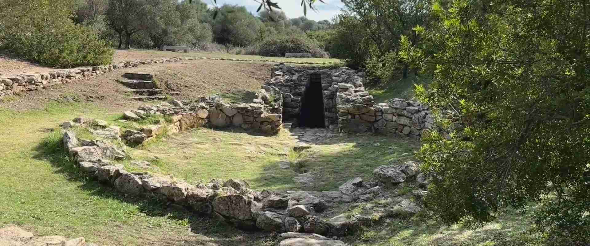
The granite uplands of Gallura, northeastern Sardinia, conceal one of the best-preserved Nuragic Bronze Age monuments: a sacred well whose keyhole-shaped plan descends through worked stone to a perennially charged spring chamber. Built in the Final Bronze Age and revered through Punic and Roman occupation, the Sacred Well of Sa Testa encodes the hydraulic mastery, structural ingenuity, and probable astronomical sensibility of a civilization that left no alphabet but wrote its beliefs in stone. This article examines its engineering anatomy, archaeoastronomical context, and cross-cultural resonances in the history of sacred water architecture.
Key Takeaways
- The Sacred Well of Sa Testa, on the outskirts of Olbia in the Gallura region of northeastern Sardinia, is assigned by the Italian Ministry of Culture–linked portal to the Final Bronze Age (approximately the 12th to 11th centuries BCE), though several official regional sources propose a wider construction window extending to the 15th century BCE; it ranks among the best-preserved Nuragic sacred wells in northern Sardinia.
- The monument extends approximately 17.47 metres in total length and integrates three interlocking spaces: a large ellipsoidal courtyard (approximately 8.30 by 7.41 metres) with continuous stone bench seating around its inner perimeter, a trapezoidal vestibule with a drainage channel in its paved floor, and a staircase of 17 steps descending to a circular well chamber whose tholos dome reached an original height of approximately 5 metres.
- Sa Testa is built from locally quarried Gallurese schist, granite, and trachyte rather than the limestone or basalt found at well temples on the island’s calcareous and volcanic geology; the first step of the stairway was finished in trachyte while the body of the structure uses schist and granite, fitted with a precision that parallels ashlar standards across the Bronze Age Mediterranean.
- Votive deposits recovered during the 1938 excavation span the Nuragic, Punic, and Roman periods, demonstrating centuries of continuous sacred use; significant finds include bronze metal objects, ceramic vessels, perfume burners, and a small female figurine carved from juniper wood, preserved by the permanently damp and anoxic conditions of the spring chamber.
- Archaeoastronomical research across the Nuragic well-temple tradition — most rigorously published for the Sacred Well of Santa Cristina near Paulilatino — has established that these monuments were oriented to channel solar or lunar light onto the water surface at cosmologically significant moments; the specific alignment properties of Sa Testa have not yet been as fully documented but its structural configuration makes it a plausible candidate for systematic survey.
- Sa Testa is a protected heritage monument under Italian cultural property legislation and is accessible to visitors near Olbia, representing a foundational landmark of the Nuragic archaeological landscape of Gallura alongside the nuraghi complexes and Giants’ Tombs of the region.
People Also Ask About the Sacred Well of Sa Testa
What is the Sacred Well of Sa Testa and how was it discovered?
The Sacred Well of Sa Testa is a Nuragic well temple located on the outskirts of Olbia in the Gallura region of northeastern Sardinia, and is one of the best-known sacred wells of the Nuragic civilization — the Bronze Age culture that flourished in Sardinia from approximately the late third millennium BCE through the Roman period. The monument’s modern archaeological discovery was not the result of a planned excavation but of a practical need: local residents searching for a fresh-water source in the 1930s uncovered the structure, leading to formal archaeological investigation in 1938 by the Superintendence for Archaeological Heritage, which documented the monument’s plan, recovered its votive finds, and published a preliminary account. The site was subsequently protected under Italian heritage law and underwent structural restoration in the late 1960s and again in 1996. Its dating is subject to some scholarly variation: the Italian Ministry of Culture–linked portal idese.cultura.gov.it assigns it to the Final Bronze Age (12th to 11th centuries BCE), while the official Sardinian Regional Tourism Authority and several other sources attribute it to the period between the 15th and 13th centuries BCE. The well’s votive deposits testify to its continuous use from the Nuragic period well into the Roman Imperial era.
How was the tholos dome of a Nuragic well temple engineered without mortar?
The tholos dome of a Nuragic well chamber is a corbelled false vault: a self-supporting domed ceiling built by projecting each successive course of stone slightly inward beyond the course below, reducing the diameter of the open space until the uppermost courses converge sufficiently to close the chamber. Unlike a true arch, which distributes load through wedge-shaped voussoirs in radial compression, the corbelled tholos relies on the gravitational weight of each overhanging slab pressing onto its support, stabilized by fill material packed against the exterior of the dome and by the lateral restraint provided by the surrounding earth. No mortar or metal fasteners are required. At Sa Testa, the tholos was designed to reach approximately 5 metres above the spring surface, creating a tall column of enclosed air above the water; today only approximately 1.65 metres of the dome structure survives in situ, with the remainder known through comparative reconstruction from better-preserved exemplars. Recent structural research on Nuragic dry-stone architecture has confirmed that fill material packed against the exterior shell performs a crucial structural role: it absorbs the lateral thrust of the inward-projecting courses and prevents collapse, explaining how corbelled tholos chambers have remained stable across three millennia of seismic activity without any binding agent.
What do archaeoastronomers know about the celestial alignments of Nuragic sacred wells?
Archaeoastronomical research on Nuragic sacred wells has focused most intensely on the Sacred Well of Santa Cristina near Paulilatino in central Sardinia, where the hypothesis of deliberate astronomical calibration was first advanced by Arnold Lebeuf, a professor at the Jagiellonian University in Cracow. Lebeuf and subsequent researchers — including Mauro Zedda, Franco Laner, Paolo Littarru, and Angelo Saba — have published analyses indicating that the staircase orientation and tholos aperture at Santa Cristina were designed to channel sunlight onto the water surface during the spring and autumn equinoxes, and to reflect moonlight at the time of the major lunar standstill, the peak declination reached by the moon once every 18.6 years. The circular well chamber, in this interpretation, functions as a precision optical instrument: the narrow aperture above the water surface restricts the entry of light to moments when the relevant celestial body is at or near the zenith of the shaft’s sightline, transforming the water mirror into a calendar. Leonardo Melis has proposed that similar encoding of solar and lunar turning points extended across Nuragic architecture more broadly. The specific archaeoastronomical properties of Sa Testa remain less comprehensively documented in published literature.
How do Nuragic well temples compare to sacred water architecture in other ancient cultures?
Nuragic sacred wells belong to a global pattern of independently recurrent sacred water architecture in which descent through worked or natural stone to underground water is treated as a cosmological act. The Sacred Cenote (Cenote Sagrado) at Chichen Itza in Mexico’s Yucatan Peninsula was for the Maya a naturally formed limestone sinkhole venerated as a portal to Xibalba, the Maya underworld, and a ritual offering site; unlike the built Nuragic wells, the cenote is entirely natural, but both traditions equate subterranean water with cosmic liminality and direct offerings downward into its depths. In the Indian subcontinent, stepwells known as vav in Gujarat and baoli in northern India descend through multiple terraced stone levels to underground water, with the celebrated Rani ki Vav at Patan — a UNESCO World Heritage Site — conceptualized by its 11th-century builders as an inverted temple in which each level of descent represents a stage in the soul’s passage toward the divine. All three traditions — Nuragic, Maya, and Hindu — arrive independently at the same premise: water accessed by descent through stone occupies the threshold between the human world and the sacred realm beneath it.
Extended multi-day tours – 5+ days
Featured Sardinia Multi-Day Tour Packages
8 days
Best of Sardinia, Self-Drive
- ✓ Comprehensive Sardinia tour
- ✓ Expert local guides included
- ✓ All accommodation arranged
- ✓ Transportation provided
7 days
Active Sardinia: Coast & Coves
- ✓ Comprehensive Sardinia tour
- ✓ Expert local guides included
- ✓ All accommodation arranged
- ✓ Transportation provided
7 days
7 Days Gran Tour of Sardinia and Corsica from Olbia
- ✓ Comprehensive Sardinia tour
- ✓ Expert local guides included
- ✓ All accommodation arranged
- ✓ Transportation provided
7 days
Best Journey of Sardinia – 7 Days
- ✓ Comprehensive Sardinia tour
- ✓ Expert local guides included
- ✓ All accommodation arranged
- ✓ Transportation provided
Multi-day tour packages powered by TourRadar. Prices and availability subject to change.
Gallura and the Bronze Age Sacred Landscape
The Gallura region occupies the northeastern corner of Sardinia, a terrain defined by the massive intrusion of Hercynian granitic batholiths that weather into rounded bosses, wind-polished ridges, and boulder-strewn valleys. Unlike the volcanic basalt landscape of the Meilogu plateau or the calcareous karst of the Nuorese interior, Gallura rests on geologically ancient granitic basement rock, part of the same Hercynian crustal episode that underlies much of northern Sardinia and extends into Corsica across the Strait of Bonifacio. Its coastline dissolves into the granite archipelagos of La Maddalena, while its interior rises toward the Limbara massif. This is not territory that produces the cave systems and karst springs of limestone landscapes; Gallura’s water percolates through fractures in the granite, collects in basins of more permeable schist and trachyte intercalated within the granitic mass, and emerges as springs at geologically favorable points. For the Nuragic populations who settled Gallura during the Final Bronze Age, such springs were not merely utilitarian features of the landscape but sacred ones — points where the underground world communicated with the living surface through the gift of water.
The Sacred Well of Sa Testa stands at the edge of what is now the modern city of Olbia — ancient Terranova Pausania — between the Tyrrhenian coast and the low granite hills inland. Its setting, a few hundred metres from the sea, at an altitude of approximately 33 metres, positions it within reach of both the maritime Nuragic communities of the Gulf of Olbia and the pastoral inland populations of the Gallura interior. This liminal positioning between sea and upland is characteristic of Nuragic sanctuaries, which frequently served as nodal gathering points for communities whose daily territories did not necessarily overlap. The large circular courtyard at Sa Testa, with its continuous bench seating around the inner perimeter capable of accommodating a substantial assembly, is most naturally interpreted as a communal space — a bounded, sanctified arena in which the populations of a wider catchment could congregate for seasonal ceremonies centred on the spring and its deity.
The Nuragic archaeological heritage of Gallura extends far beyond Sa Testa. The Arzachena Archaeological Park, approximately 25 kilometres northeast of Olbia, preserves eight sites including the Li Muri necropolis and the Giants’ Tomb of Li Lolghi, attesting to the density of Bronze Age sacred infrastructure in this corner of the island. Single-tower nuraghi punctuate the granite hills throughout the region, and the Giants’ Tombs — the characteristic Nuragic collective funerary monuments known in Sardinian as tumbas de sos zigantes — mark the landscape at regular intervals. Sa Testa must be read within this interconnected monument landscape rather than as an isolated curiosity. Its sophistication — the precisely worked stone, the domed chamber, the large communal courtyard — suggests a regional sanctuary of considerable ritual prestige, one that drew populations from a wide area of the Gallurese territory and maintained that role across several centuries of occupation.
The Nuragic Civilization and Its Water Theology
The Nuragic civilization takes its name from the nuraghe (plural: nuraghi), the truncated-cone stone towers that are its most visible legacy: approximately 7,000 to 8,000 of these structures survive in Sardinia, making the island one of the most densely marked prehistoric landscapes in the Mediterranean. The civilization flourished from roughly 1800 BCE, when the first tholos towers were raised, through the gradual incorporation of the island into the Carthaginian and then Roman spheres of influence — a process that was neither sudden nor complete, since Nuragic ritual practices demonstrably continued well into the historical period, as the Roman-phase votive deposits at Sa Testa and many other sanctuaries confirm. Giovanni Lilliu (1914–2012), the preeminent twentieth-century scholar of Nuragic Sardinia, spent a career documenting the civilization’s architectural and material record from its earliest corridor nuraghi through the complex polylobate fortresses of the Middle Bronze Age and the sanctuary architecture of the Final Bronze Age. It is within this final constructional phase that the well temples belong.
The Nuragic people left no written records. Their religious beliefs are therefore reconstructed from the archaeology of the sanctuaries themselves, the nature and distribution of votive deposits, the spatial relationships between architectural elements, and the figurative bronze statuettes that depict warriors, priests, navigators, musicians, and deity-like figures with raised arms. From this evidence, scholars have proposed that Nuragic religion centred on a suite of forces that governed agrarian and pastoral life: water, which determined the fertility of the land in a semi-arid island climate; the sky and its cycles, which governed the seasons; and the boundary between the living world and the world of the dead and the divine, a boundary that underground water was understood to mark or traverse. The sacred wells are material expressions of all three concerns simultaneously — hydraulic infrastructure, cosmological architecture, and ritual landscape all at once.
Water theology in Bronze Age Sardinia drew on an experience directly familiar to any agrarian community in the Mediterranean: the unpredictability of rainfall and the life-and-death importance of reliable springs. A spring that did not depend on seasonal rains — one that welled up from the rock with apparent constancy across wet years and dry — was invested with particular numinous significance. It came from below the earth, from the domain of subterranean powers, and it represented a point of direct communication between the living community above and whatever forces governed the continuity of life beneath. Offerings placed into such springs — and the deposits at Sa Testa and other well temples make clear that ritual offering was the primary practice — were directed downward, toward those underground powers, in exchange for the continued gift of water and fertility. The sacred well was, in this framework, less a water source than an address: a permanent point of correspondence between the two worlds.
The formal architecture of the Nuragic well temple — the monumental courtyard, the vestibule, the staircase, the domed chamber — transforms what might otherwise be a simple spring into a spatially regulated ritual experience. Entry through the courtyard, passage through the vestibule, and descent through the staircase enact a sequence of progressive spatial constriction and darkening that mirrors the spatial grammar of liminal passage documented by the French folklorist and ethnographer Arnold van Gennep in his analysis of ritual transitions: a public threshold, a marginal passage, and an enclosed centre where contact with the sacred is fully achieved. Whether the Nuragic builders theorized their architecture in such terms is of course unknowable, but the spatial logic they produced corresponds precisely to this grammar, and the investment of communal labour required to construct these monuments makes incidental correspondence implausible.
The UNESCO Tentative List entry for the Nuragic Civilization of Sardinia notes that between the 12th and 6th centuries BCE, sacred wells, spring sanctuaries, megaron temples, and circular cult buildings multiplied across the island, representing a phase of intensified institutional religious architecture that followed the peak period of nuraghe-fortress construction. The social function of communal sanctuaries — places of pilgrimage, seasonal assembly, and ritual exchange among populations of different territories — appears to have displaced, or at least complemented, the defensive and prestige functions of the great fortress nuraghi as the primary focus of community building investment during the Final Bronze Age. Sa Testa belongs to this moment of sanctuary elaboration, when the Nuragic communities of Gallura channeled their collective capacity for architectural achievement into the construction of a well temple whose scale and precision were evidently intended to signal the sacred importance of its spring.
The Structural Anatomy of the Nuragic Well Temple
The physical form of the Nuragic sacred well follows a typological template that recurs, with variations of material and scale, at well-preserved examples across Sardinia. At Sa Testa, the template is expressed in three interlocking spatial units — courtyard, vestibule, and descending shaft with its domed chamber — each performing a distinct architectural and ritual function while contributing to the hydraulic and optical coherence of the whole. Understanding each component requires attention to both its constructional logic and the specific Gallurese geological conditions under which it was realized.
The courtyard at Sa Testa is the largest and most public element of the complex. Ellipsoidal in plan, it measures approximately 8.30 by 7.41 metres internally and is enclosed by a low curved wall approximately 94 centimetres wide and 30 centimetres high. Along the entire inner base of this wall runs a continuous bench seat ranging from 39 to 69 centimetres in width and approximately 45 centimetres in height — dimensions proportioned for a seated adult, and configured so that the assembled community faces inward toward the entrance to the well temple proper. The paved courtyard floor is crossed by an underlying drainage channel for the controlled outflow of overflow water. Access to the courtyard is through an opening on the north side, approached by a small staircase of four steps. In official Sardinian cultural authority documentation this space is referred to as the sala del consiglio — council room — though this designation reflects interpretive tradition rather than any documented Nuragic terminology.
From the far end of the courtyard, the spatial sequence narrows sharply into the vestibule: a small trapezoidal room with its own stone bench seats along the side walls, its own drainage channel in the paved floor, and a plan measuring approximately 2.62 metres in both length and maximum width. This space performs the function of an architectural decompression zone, reducing scale and light level before the descent begins and marking the transition from communal outdoor assembly to the more intimate approach toward the spring. The trapezoidal profile — broader at the courtyard threshold, narrowing toward the stairhead — creates a subtle perspectival compression that emphasizes directionality and intention, channeling attention downward toward the well chamber.
The staircase descends through 17 steps from the vestibule level to the well chamber, where the perennial spring vein is captured. At the base of the chamber, a platform approximately 35 centimetres high encircles a circular recess of approximately 50 centimetres in diameter from which the spring water flows. The staircase walls rise around the descending visitor, narrowing the field of vision to a vertical slit of sky above and the reflective surface of the water below. The acoustic properties of the enclosed stone shaft concentrate sound — footsteps, water movement, voiced ritual — with an intensity that amplifies the sensory experience of the descent. The shaft is not simply a passage of access; it is itself an instrument of ritual preparation, a spatial technology for producing the altered perceptual state in which sacred encounter was understood to occur.
Tholos Dome Engineering and Hydraulic Pressure Control in the Bronze Age
The circular well chamber at the base of the staircase was originally covered by a tholos dome designed to reach approximately 5 metres above the water surface — today only approximately 1.65 metres of the original dome structure survives in situ, the remainder reconstructed comparatively from better-preserved well temples. The tholos is built in the corbelled technique that is the signature structural device of Nuragic monumental architecture across both the nuraghi towers and the well temple type. In corbelling, no voussoirs transmit radial compression as in a true arch; instead, each course of stones projects inward slightly beyond the course beneath, relying on the weight of the overhanging mass, the friction between courses, and — crucially — the lateral pressure of fill material packed against the exterior of the dome to maintain equilibrium. The load path is primarily vertical: each corbelled slab presses downward onto the one below, and outward thrust is contained by surrounding earth and rubble fill rather than by the geometry of the vault itself. This technique requires no mortar and no permanent scaffolding beyond the temporary platforms needed to place each successive course.
For the well chamber specifically, the corbelled tholos carries hydraulic implications beyond its structural function. The sealed domed interior creates an enclosed column of still air above the water surface. In a spring system where groundwater rises to the phreatic level — the depth at which the pressure of the surrounding saturated rock forces water upward — the closed air column above a chamber at equilibrium contributes to stabilizing the water surface and damping its response to external pressure fluctuations. The height of the tholos above the spring mouth, combined with the substantial thermal mass of the surrounding stone and earth, maintains the chamber interior at a relatively cool, constant temperature year-round. This has documented practical consequences: cool enclosed air reduces evaporation from the water surface, limits microbial growth that might cloud or contaminate the water, and maintains access reliability through the extremes of the Sardinian summer. Whether the Nuragic builders consciously articulated these advantages in engineering terms or arrived at the domed well chamber through empirical refinement of a developing typology is unknowable, but the structural choice produced undeniable functional benefits across a demanding hydraulic environment.
The drainage channels cut into the paved floors of the vestibule and courtyard complete the hydraulic management system by directing overflow water away from the ritual space. In periods of elevated rainfall or raised water table, spring water ascends the lower steps of the staircase; the vestibule and courtyard channels conduct this overflow out of the enclosed complex without flooding the assembly space. The system as a whole — sealed dome, stable thermal environment, overflow management — constitutes a Bronze Age hydraulic apparatus of considerable sophistication, one that managed a dynamic and seasonally variable hydrological situation without mortar, metal fittings, or any binding agent beyond the weight and geometry of its stones. Recent structural research on Nuragic dry-stone construction has confirmed the critical role of granular fill material — small stones, earth, and rubble packed against tholos exteriors — in absorbing lateral thrust from corbelled courses and preventing rotation, explaining how these structures have maintained structural integrity across three thousand years of seismic activity and weathering without any consolidating agent in their joints.
The optical geometry of the tholos aperture above the water surface operates in parallel with the hydraulic geometry. A narrow circular opening at the apex of a high dome over a water mirror creates a precisely defined cone of sky access: only when a celestial body is positioned within the angular cone defined by the aperture does its light descend unobstructed to the water surface below. This transforms the chamber from a passive spring enclosure into a selective optical instrument — a device that responds to the sky only at specific, geometrically determined moments. The height of the tholos above the water, the diameter of the aperture, and the orientation of the shaft together determine which sky events the instrument can register. The builders of Nuragic well temples appear to have understood this optical property, at least empirically, and may have used it deliberately in setting the orientation and dimensions of their monuments.
The Vestibule and the Precision-Cut Limestone Ashlar Steps
The broader well-temple tradition in Sardinia is strongly associated in scholarship with precision stone cutting of a quality described as ashlar masonry — blocks cut to regular, closely fitting dimensions and laid in even courses that seat tightly without mortar or substantial packing. The canonical exemplar of this standard is the Sacred Well of Santa Cristina near Paulilatino, whose trapezoidal staircase of 25 steps is constructed from carefully shaped basalt blocks of extraordinary regularity; limestone ashlar of comparable precision characterizes well temples built on the calcareous formations of central and southern Sardinia, where the sedimentary bedding planes and relatively tractable cutting properties of carbonate rock lend themselves to the fine, even fracture surfaces that true ashlar demands. The term “limestone ashlar” in the well-temple typological literature therefore accurately describes the standard of cutting quality and the predominant material of the tradition’s most celebrated examples.
Sa Testa presents a significant material variant specific to Gallura’s geological character, and the discrepancy merits direct acknowledgment. The blocks from which the vestibule, staircase, and courtyard walls are built are not limestone but locally quarried schist, granite, and trachyte — the characteristic rock types of the Hercynian granitic basement of northeastern Sardinia. According to the Italian Ministry of Culture–linked documentation at idese.cultura.gov.it, the first step of the stairway was finished in trachyte while the remainder of the structure uses schist and granite. This material allocation reflects a degree of geological literacy on the builders’ part: schist, with its natural foliation planes, can be split into flat slabs suited to treads and paving where a broad, regular surface is needed; trachyte, which has a finer grain and more predictable fracture behaviour than the coarse local granite, was used for the dressed first step where the quality of the surface was most critical to the approach experience; and granite — the most abundant material in Gallura — provided the mass of the enclosing walls and the outer shell of the well shaft, where compressive load-bearing capacity mattered more than surface precision.
The quality of fitting achieved at Sa Testa within these geological constraints is what connects it to the ashlar tradition even when the material differs from the limestone or basalt of better-known sites. The “ashlar” designation refers properly to a standard of cutting precision and joint tightness rather than to a specific stone type. At Sa Testa, the builders achieved the functional standard — tight, mortar-free joints; regular course heights; coherent surface planes — through judicious material selection and careful working of stones that are structurally more demanding than limestone to cut cleanly. The result is a masonry shell capable of resisting lateral earth pressure and groundwater seepage without the aid of any consolidating agent, exactly the structural performance that an underground spring chamber requires for longevity.
The consequences of this precision are not merely structural. Tight-fitted dry-stone masonry behaves as a coherent shell rather than a collection of individual blocks: loads distribute across the entire course rather than concentrating at individual block interfaces, and the absence of voids eliminates the pathways for water ingress and particle migration that destabilize courses over time. That Sa Testa has survived more than three thousand years with its staircase substantially intact — visible and descended by visitors today — is a direct consequence of the care with which its builders selected, worked, and fitted their stone in the materially demanding geological conditions of Gallura.
Sa Testa’s Gallurese Stone: Geology, Material Selection, and Spatial Organization
Gallura’s geological substrate is dominated by Hercynian granitic intrusions — mostly coarse-grained, ranging from grey to the pink varieties of the Costa Smeralda area — that are among the hardest common building stones available anywhere in Sardinia. Interspersed with the granite are outcrops of metamorphic schist, older rocks caught between the igneous intrusions, and bodies of trachyte at the transitional zones between different igneous episodes. The Nuragic builders of Sa Testa worked with all three of these materials, selecting each for the role that best matched its physical behaviour. This is not a trivial observation: working granite with Bronze Age tools — stone and copper or bronze percussion and grinding implements — is substantially more demanding than working basalt or limestone, and the decision to build in granitic terrain rather than relocating to more tractable geological ground reflects the primacy of the spring location over the convenience of the building material.
Schist, with its pronounced foliation, can be split along natural cleavage planes into relatively flat slabs useful for floor paving and stepped treads. The drainage channels in the vestibule and courtyard floors, and the broad horizontal surfaces of the stair treads, most probably exploit schist’s amenability to flat-slab production. Trachyte, which has a somewhat finer grain and more predictable fracture than the local granite, was evidently considered the premium material for the most visible and tactile element of the descent — the first step, where a visitor’s first contact with the subterranean sequence begins. Granite, the most abundant material in the Gallura landscape, provided the structural mass of the courtyard enclosure wall and the outer shell of the well shaft, where volume and compressive strength matter most.
This differentiated material allocation within a single monument reflects practical geological literacy of a kind transmitted through craft apprenticeship rather than written technical specification. A builder who knew from experience which local stone split cleanly along natural planes, which could be ground to a reliable surface, and which resisted lateral fracture under percussion — and who allocated each to the structural task that best exploited its properties — was operating with a sophisticated material knowledge that the finished monument makes legible even though no accompanying text survives. Sa Testa is, among other things, a document of Gallurese Bronze Age geology and the practical intelligence the Nuragic builders developed in response to it.
The spatial organization of Sa Testa’s plan — the keyhole or lock-shaped footprint visible in any plan drawing — is not an accidental consequence of its functional requirements but a typological form that recurs across Nuragic well temples and must therefore reflect intentional design. When viewed from above, the ellipsoidal courtyard, the narrow vestibule, and the circular well shaft below create a silhouette widely compared in both scholarly and tourist literature to a door lock or keyhole, with the constriction between courtyard and shaft suggesting the functional analogy of a key turning in a lock — or, as the Sardinian Regional Tourism Authority describes it, a door that separates the world of the living from the world of the dead. The spatial sequence literalizes the keyhole metaphor: the courtyard is the face plate, the vestibule is the barrel, and the well chamber is the bolt-mechanism — the point of mechanism, of contact, of functional operation. This is architectural metaphor of considerable sophistication, even if we cannot know whether the Nuragic builders consciously articulated it in these terms or whether the cultural interpretive tradition that describes Sa Testa as a portal between worlds is a reading of the structure rather than a report of its builders’ intentions.
Archaeoastronomy of the Water Cult: Solar and Lunar Alignments
Among the most productive and contentious hypotheses in Nuragic studies is the proposition that sacred wells were not only hydraulic and ritual structures but precision instruments for astronomical observation. This hypothesis rests on the fundamental optical property of a narrow vertical shaft terminated by a water mirror: such a shaft severely restricts the angles at which external light can enter and reach the water surface, and the celestial body or bodies whose light can penetrate to the bottom are exactly those passing through a narrow cone of sky defined by the shaft geometry. By manipulating the orientation, diameter, and depth of the shaft, a builder could in principle calibrate which celestial events would be visible in the water mirror, and at what time of year or month those events would occur. The well temple becomes, in this framework, an instrument whose output is astronomical information encoded in the appearance or non-appearance of light on the water surface.
The hypothesis was given its most influential early formulation by Arnold Lebeuf of the Jagiellonian University in Cracow, who proposed that the Sacred Well of Santa Cristina near Paulilatino was designed to receive moonlight onto its water mirror at the time of the major lunar standstill — the moment, recurring approximately every 18.6 years following the draconic cycle of the moon’s nodal precession, when the moon reaches its maximum northern or southern declination and its path across the sky reaches its extreme. Subsequent researchers — including Mauro Zedda, Franco Laner, Paolo Littarru, and Angelo Saba, who have published analyses in archaeoastronomical literature — examined the Santa Cristina alignment in detail and reported that the monument’s documented orientation from north-northwest to south-southeast, its staircase inclination, and its chamber geometry are consistent with lunar illumination of the water surface at the major standstill, and also with solar illumination during the spring and autumn equinoxes. In this interpretation the circular well chamber, with its upward aperture, functions as what archaeoastronomical commentary on the site has called a “celestial mirror”: the water surface reflecting overhead sky events that are otherwise difficult or impossible to observe from the ground by direct viewing.
The broader pattern of deliberate astronomical encoding in Nuragic architecture extends beyond the well temples. Leonardo Melis has researched the orientation of loopholes and openings in nuraghi towers, and has documented cases — notably at the Nuraghe Aiga near Abbasanta — where light entering a tholos aperture at noon on the summer solstice illuminates a niche directly opposite the entrance with a precision that, in Melis’s analysis, requires both the geometrical calculation of the solar angle and the careful dimensioning of the dome, base structure, and niche position. The cumulative picture that emerges from this body of research is one of a Bronze Age civilization in which the observation and celebration of solar and lunar cycles was integrated into the building programme of its major ritual monuments, with architectural geometry serving as the instrument for encoding and displaying those observations.
Zenith Light Penetration and the Autumnal Equinox Phenomenon
The optical mechanics of zenith light penetration in a narrow well shaft are most fully and rigorously documented at the Sacred Well of Santa Cristina. During the spring equinox (approximately 20–21 March) and the autumn equinox (approximately 22–23 September), the rising sun at Santa Cristina aligns with the north-northwest to south-southeast orientation of the monument, and sunlight descends the staircase shaft to illuminate the water surface at the base. The graduated profile of the basalt stair treads creates a pattern of alternating light and shadow during the penetration event that would be visible to any observer positioned in the vestibule. This equinox phenomenon has been confirmed by multiple archaeoastronomical observers and is consistent with the monument’s documented geometry; the phenomenon is not merely a curiosity but a calendrical mechanism, capable of marking the equinoxes with considerable precision for a community that depended on seasonal tracking for agricultural planning. The large ellipsoidal courtyard at Santa Cristina, like that at Sa Testa, provided the communal space in which an assembled gathering could witness the event.
For Sa Testa specifically, the published archaeoastronomical literature is appreciably less developed. The monument’s orientation as reported in available survey data — described in one source as west-facing — would produce a different alignment geometry from the east-facing equinox sunrise alignment documented at Santa Cristina. A west-oriented well shaft might, in principle, be calibrated for sunset events or for lunar illumination from a western sky position rather than for the equinox sunrise. This structural difference makes it important to maintain clear analytical separation between what is established for Santa Cristina (a reasonably well-documented archaeoastronomical alignment, with published analyses) and what is proposed or suggested for Sa Testa (a structural configuration that invites archaeoastronomical examination but has not yet been the subject of a systematic, published alignment survey). The hypothesis that Sa Testa participates in the same tradition of astronomical encoding as Santa Cristina and other Nuragic monuments is plausible and well-grounded in the typological parallel; the specific parameters of any such alignment at Sa Testa remain an open research question requiring on-site survey.
The concept of zenith light penetration — the use of a narrow vertical shaft to concentrate celestial light onto a reflective surface at the base — has analogues in prehistoric sacred architecture beyond Sardinia, and these parallels underscore the architectural insight’s breadth. The most celebrated related example is Newgrange in the Boyne Valley of Ireland (dated to approximately 3200 BCE), where a precisely engineered roof box above the entrance passage channels the winter solstice sunrise down a 19-metre corridor to illuminate the inner chamber for approximately 17 minutes. Newgrange is far older than the Nuragic well temples and arose in a radically different cultural and geographical context, yet the underlying principle is identical: a narrow aperture constrains the entry of light to a specific sky position defined by the geometry of the shaft, transforming the structure into a calendar that announces a particular celestial event through a beam of light on a prepared surface. This convergence — the optical well or light shaft as a celestial detector — is one of the most striking instances of independently recurrent architectural intelligence in the prehistoric record, and its appearance in Bronze Age Sardinia places the Nuragic well temples within a global tradition of monumental astronomical architecture whose nodes are separated by geography, culture, and centuries but united by the same structural insight.
The ritual significance of the light-on-water phenomenon, whatever its specific astronomical calibration, would have been immediately legible to a Nuragic community assembled in the courtyard and vestibule at the moment of a solar or lunar penetration event. The appearance of light on the spring surface — on the very water that the community understood as the gift of the underground powers — would have constituted a visual merger of sky and underworld: the celestial fire arriving at the subterranean water, heaven touching the below-ground sacred centre. This conjunction of cosmic registers in a single visual moment is precisely the kind of event around which ritual communities organize their most potent ceremonial occasions, and its periodic recurrence — tied to an astronomically defined calendar rather than to any human choice — invested the event with the authority of natural necessity. The well temple that produced this effect was not merely architecture; it was a cosmic apparatus.
The Keyhole Plan: Sacred Geometry and Symbolic Spatial Descent
The planimetric form of the Nuragic well temple — wide at the courtyard, narrowing through the vestibule, descending through the circular shaft to the domed chamber — has been compared across both scholarly and popular literature to a keyhole or door lock, and this comparison carries interpretive weight beyond its descriptive aptness. The progressive reduction in spatial scale as one moves toward the spring — from the courtyard that accommodates a community, through the vestibule that admits a small group, down the staircase that fits a single body in descent, into the chamber that holds one person and a mirror of water — is not incidental to the design but central to its ritual logic. It enacts in spatial experience the idea that access to the sacred is progressively restricted, that the closer one comes to the sacred centre, the more individuated and intense the encounter becomes.
This spatial grammar of constriction toward the sacred is one of the most persistent patterns in the global history of religious architecture. Egyptian temples contract from large forecourts through hypostyle halls to inner sanctuaries that only the high priest could enter. Romanesque churches narrow from nave through choir to apse, reducing the congregation to the officiant as the Eucharistic centre is approached. Hindu temples move from the open mandapa (assembly hall) through the antarala (antechamber) to the garbhagriha (womb-chamber) in which the deity resides. None of these traditions influenced the Nuragic well temples, which predate most of them by centuries, but all of them generate the same architectural grammar because the grammar arises from something intrinsic to the phenomenology of sacred space: the intuition that the divine is encountered in conditions of enclosure, reduced sensory noise, and spatial concentration. The keyhole plan is not borrowed from an external model; it is generated by the logic of sacred access itself, which the Nuragic builders appear to have understood and architecturally expressed with unusual purity.
The term “sacred geometry” in the context of Nuragic well temples, including in the title of this article, should be understood precisely in this experiential and spatial sense rather than as a claim that the builders operated with an abstract mathematical system of proportional ratios or symbolic number sequences — for which no documented evidence exists in the Nuragic record. The spatial ratios implicit in the well temple plan at Sa Testa reflect a geometrically coherent and purposefully composed sacred programme: a courtyard proportioned for communal assembly (approximately 8.30 by 7.41 metres), a precisely square vestibule (approximately 2.62 by 2.62 metres) that conveys bilateral symmetry and equilibrium at the threshold, and a shaft whose depth-to-width ratio concentrates the overhead sky into the narrow optical cone described in the archaeoastronomy sections above. These proportional decisions — whether arrived at through explicit calculation, through typological convention refined over multiple construction cycles, or through the empirical knowledge of builders who had internalized what worked — constitute a coherent spatial geometry in service of a consistent experiential and cosmological programme.
A note on the step count of 17 at Sa Testa: this number has occasionally attracted speculation about cosmological significance, particularly in the context of lunar or calendrical numerology. The available scholarly literature does not support such a reading for Sa Testa specifically. Other Nuragic wells have different step counts — Santa Cristina has 25, Su Tempiesu descends to the spring at its own depth — indicating that the count was determined by the practical requirement of reaching the water table at each site’s specific aquifer depth, not by a symbolic arithmetic programme. The depth of the spring at Sa Testa required 17 steps with the riser heights the builders chose; at other sites different aquifer depths required different step counts. This is a point where honest archaeological caution is more useful than numerological elaboration: the structural evidence does not support reading a mystical programme into the step count, and the simpler hydraulic explanation is the one supported by comparative evidence across the well-temple type.
Votive Life of the Well Temple: Archaeological Finds and Ritual Continuity
The votive deposits recovered from Sa Testa during the 1938 excavation provide the most direct evidence available for the ritual life of the sanctuary across its long period of use. The material was published in preliminary form in D. Levi’s 1938 account in the journal Le Arti (I-2, 1938, pp. 214–215), and subsequently examined in greater detail by Fulvia Lo Schiavo in a contribution to the volume Olbia e il suo territorio: storia e archeologia (Ozieri: Il Torchietto, 1991, pp. 133–134), and by M.A. Amucano in Da Olbia a Terra Nova: itinerari storici, archeologici, monumentali (Olbia: Coop. Iolao, 2004, pp. 37–40). The finds collectively demonstrate that Sa Testa was in active sacred use not only during the Nuragic period of its construction but across the subsequent Punic and Roman phases of Sardinian history — a continuity spanning several centuries across radically different political and cultural administrations.
The core categories of votive material are consistent with the pattern documented at other Nuragic water sanctuaries across Sardinia. Bronze metal objects represent the Nuragic contribution most prominently. The Nuragic civilization produced some of the technically most accomplished bronzework in the Bronze Age Mediterranean, and offerings in bronze — weapons, ornaments, miniature implements — were among the most prestigious forms of votive gift available. The deposition of bronze objects into a sacred spring was an act of permanent sacrifice: bronze, irretrievable from the depths, given over permanently to the underground powers as evidence of a community’s devotion and as an investment in the continued benevolence of the spring deity. Ceramic vessels of multiple Nuragic fabric types were also recovered, representing the quotidian dimension of offering practice alongside the prestige bronze: pottery used to present liquids, grains, or prepared foods as gifts to the water.
The Punic-phase material from Sa Testa includes perfume burners known archaeologically as thymiateria, objects widely distributed across Carthaginian-period Sardinia from the fifth century BCE onward. The burning of aromatic substances in the presence of a sacred spring — combining fire with water in a structurally enclosed space — is attested at sanctuary sites across the ancient Mediterranean and belongs to a practice vocabulary that both the Nuragic tradition and the Phoenicio-Punic tradition of the western Mediterranean shared or developed in parallel. The presence of these objects at Sa Testa indicates that the well retained its sacred character under Punic religious practice; the specific theological framework in which the spring deity was venerated presumably shifted with the Carthaginian presence, but the practice of approaching the water with offerings and aromatic burning persisted across the cultural change.
The most remarkable single find from Sa Testa is a small female figurine carved from juniper wood. Organic materials very rarely survive in Mediterranean archaeological contexts, where the combination of temperature variation, seasonal moisture fluctuation, and microbial activity destroys most wood within decades. The preservation of this wooden statuette across more than three thousand years is attributable to the hydrological conditions of the well chamber itself: the permanently damp, cool, and low-oxygen environment around and below the water surface can, under specific conditions, inhibit the microbial and oxidative processes that normally decompose wood. The figure’s survival suggests it was deposited directly at or near the waterline, where saturation created the anoxic conditions that prevented decomposition. Its subject — a female silhouette — is consistent with the widespread association between female sacred figures, fertility, water, and the earth in prehistoric Mediterranean religions, and it offers a rare and fragmentary glimpse into the iconographic world of Nuragic water religion that the more durable bronze and ceramic finds cannot provide.
The Roman-period ceramic and metal material from Sa Testa — attributable to the Imperial era — establishes that the site continued to receive votive attention well after Sardinia’s incorporation into the Roman provincial system in 238 BCE. This pattern is widespread across the Nuragic sacred landscape: many Nuragic well temples and sanctuary sites show evidence of Roman-period activity, suggesting that the Roman administration found it more practical to permit the continuation of local cult practices at sacred springs — whether reinterpreted within a Roman religious vocabulary or simply tolerated as indigenous practice — than to suppress sanctuaries that served as important community focal points. The spring at Sa Testa endured regardless of political change, and with it the ritual geography it had anchored for a millennium or more before the first Roman soldier arrived on the island.
Cross-Cultural Parallelisms: Sacred Descent and Cosmic Water Architecture
The construction of an underground water chamber, accessed by a descent through worked stone, as the physical locus of contact between the human community and the forces that govern fertility, death, and cosmic order is not a uniquely Nuragic discovery. Across time and geography, independent cultures have arrived at structurally or conceptually similar solutions to the architectural problem of how to encounter sacred water — water that belongs simultaneously to the earth, the underworld, and the sky. Two traditions in particular invite systematic comparison with the Nuragic well temples: the Maya cenotes of the Yucatan Peninsula, and the Hindu stepwells of the Indian subcontinent. In both cases the parallel must be understood as evidence of convergent independent development — the recurrent emergence of similar structural or ritual responses to similar experiential and theological circumstances — rather than of any genealogical connection, shared influence, or diffusionary contact. No historical channel links Bronze Age Gallura to Classic-period Yucatan or eleventh-century Gujarat; the parallels arise from the universal logic of sacred water, not from cultural borrowing.
The Sacred Cenote (Cenote Sagrado) at Chichen Itza in Mexico’s Yucatan Peninsula is the most famous sacred water space in the ancient Americas. Unlike the Nuragic well temples, the Sacred Cenote is not a constructed space: it is a natural karstic sinkhole in the porous limestone of the Yucatan Peninsula, where the dissolution of subsurface bedrock by groundwater has created a dramatic circular pit whose vertical limestone walls drop to a permanent freshwater surface below. For the Maya civilization, cenotes of this character were sacred because they were given rather than made: they were understood as naturally occurring portals to Xibalba, the Maya underworld, a watery subterranean realm governed by death deities and ancestral powers. The name Chichen Itza itself translates approximately as “at the mouth of the well of the Itza,” encoding the sacred cenote into the city’s foundational identity. Ritual offerings recovered from the Sacred Cenote through dredging operations that began in the late nineteenth century include objects of jade, gold, and copper; ceramic vessels; incense; and occasional human remains — all directed downward, into the subterranean water, as communications with the underworld powers that the cenote made accessible.
The structural contrast between the Sacred Cenote and Sa Testa could not be more complete: one is wholly natural, the other entirely built. Yet the cosmological parallel is precise. Both represent subterranean water as a threshold — the Maya cenote opens down into Xibalba; the Nuragic well descends through 17 steps to a spring chamber whose keyhole plan is described in official heritage documentation as marking the boundary between the world of the living and the world of the dead. Both involve offerings directed downward into the water as communications across that threshold. Both are associated with rain, fertility, and the divine forces that govern the agricultural cycle — the Maya rain deity Chaac was particularly connected to cenotes, while the Nuragic water deity, unknown by name, governed the springs on which Sardinian agriculture depended. The conceptual equation is identical even though the physical instantiation is produced by different geological settings: where Gallura’s granite provided an unremarkable spring that required the full investment of monumental architecture to become a sacred space, the Yucatan’s karst provided dramatically formed natural sinkholes that required only cosmological attribution to function as temples. Two geological situations; one theological logic.
The astronomical dimension of the Nuragic well temples has a partial analogue at Chichen Itza — but displaced from the cenote itself onto the adjacent built architecture. The famous equinox shadow effect at the Pyramid of Kukulcán (El Castillo), in which the stepped balustrades of the pyramid cast a serpent-like shadow on the northern staircase at the spring and autumn equinoxes, is one of the best-documented architectural solar alignments in the ancient world: the pyramid’s four sides are oriented to the cardinal directions with sufficient precision to produce the visual effect of a feathered serpent ascending and descending the staircase at the equinox moments. This astronomical encoding is embedded in a surface structure rather than a subterranean shaft, and the event is expressed as shadow rather than as light-on-water, but the underlying architectural intelligence — encoding celestial turning points into the spatial and visual experience of a sacred site — parallels the logic of the Nuragic well alignments even as the architectural means and the cultural context differ entirely. At Chichen Itza the cenote (water below, cosmological gateway) and the pyramid (astronomical instrument above) together constitute the sacred landscape; at the Nuragic well temple, a single structure attempts to perform both functions within the vertical extent of one shaft.
The Hindu stepwells of the Indian subcontinent provide a third comparative case, and in some respects the structurally closest one, since they involve a deliberately built descending staircase to underground water rather than the natural sinkhole of the Maya cenote. The term “stepwell” encompasses a family of water architecture distributed across South Asia and known by regional names: vāv in Gujarat, bāolī (also baori or bawdi) in northern India and Rajasthan, jhalra in parts of Marwar. All share the defining principle of a staircase — sometimes very elaborate, with multiple terraced levels, colonnaded corridors, and pavilions — that provides direct access to groundwater whose level fluctuates seasonally. Documentary records and structural evidence trace the stepwell tradition in India to at least the early centuries of the Common Era, with elaborately carved exemplars flourishing between the seventh and thirteenth centuries CE; proto-forms of the stepped water-access concept may extend further back in the Indus Valley civilization’s hydraulic infrastructure, though the connection is contested.
Rani ki Vav — the Queen’s Stepwell at Patan in Gujarat, a UNESCO World Heritage Site inscribed in 2014 — is the most celebrated surviving example and the most instructive for comparison with the Nuragic well temples. Commissioned in the late eleventh century CE by Queen Udayamati as a memorial to King Bhimdev I of the Chaulukya (Solanki) dynasty, Rani ki Vav extends approximately 65 metres in length and descends through seven levels of stairs and terraces to a depth of approximately 23 to 27 metres, with over 500 principal sculptures and more than a thousand smaller carvings covering its internal walls and pillars. The UNESCO World Heritage citation describes its design concept as that of an “inverted temple”: a temple whose vertical axis points downward rather than upward, and in which the descent through the staircase levels represents a spiritual journey from the surface world toward divine water below. The deepest level, where Lord Vishnu resides in the monument’s iconographic programme, corresponds to patala — the Hindu conceptual subterranean realm of divine waters. Every level of descent at Rani ki Vav was understood to represent the transition from the earthly realm toward the divine, culminating in a sanctum at the deepest point where the water chamber symbolizes the cosmic underworld.
The parallels with the Nuragic well template are structural, cosmological, and phenomenological simultaneously. Both Sa Testa and Rani ki Vav descend through precisely worked stone steps to underground water, using the architecture of descent as the physical enactment of passage from the everyday world to a sacred realm beneath. Both employ a graduated spatial compression — at Sa Testa from courtyard to vestibule to shaft; at Rani ki Vav from the open upper terrace through progressively narrower and more sculpturally dense galleries — that intensifies the experience of sacred approach as depth increases. Both treat the water encountered at the bottom not as a resource but as a divine presence: at Rani ki Vav explicitly identified through its iconographic programme with Vishnu and the cosmic underworld; at Sa Testa implied by the architectural investment, the votive deposits, and the keyhole plan that marks the well as a portal. And both impose an axis of descent that functions cosmologically as a kind of inverted axis mundi — not the upward axis of a tower or sacred mountain reaching toward the sky, but a downward axis reaching toward the earth’s interior, inverting the usual polarity of sacred verticality to locate the divine not above but below.
What the three traditions share across their enormous differences of geography, period, material, and cultural content is the architectural recognition that water accessed by descent through stone occupies a different category of experience from water encountered at the surface. It is cooler, quieter, more enclosed, more remote from the quotidian world. Arriving at it requires effort and spatial passage. The descent itself is a rite, and the water encountered at the bottom of a stone shaft — whether a built Nuragic chamber in Gallurese granite, a carved Hindu gallery in Gujarat sandstone, or the still surface of a natural Maya cenote — is the water of the threshold: the water that belongs to both worlds at once, and that the human community approaches to make its offerings and to receive what the underground powers are willing to give.
Heritage Status, Conservation History, and Visiting Sa Testa
The modern archaeological discovery of Sa Testa was not the outcome of a planned excavation campaign but of a practical domestic impulse: local residents and shepherds searching for a fresh-water source in the 1930s exposed the monument, prompting formal investigation in 1938 by the Superintendence for Archaeological Heritage. The 1938 excavation documented the monument’s plan, recovered its votive deposits, and produced a preliminary publication by D. Levi in the journal Le Arti. The structural integrity of the well was subsequently protected under Italian cultural property legislation — specifically Law 1089/1939, articles 2 and 3, under which Sa Testa is formally listed. Structural restoration work was carried out in the late 1960s (with Ercole Contu associated with the 1969 intervention in some sources), stabilizing masonry elements that had shifted or collapsed, with a further consolidation and restoration programme completed in 1996. The site as visible today reflects this conservation history: the courtyard and vestibule are largely intact; the tholos dome survives to approximately 1.65 metres of its original approximately 5-metre height, with the lower staircase steps permanently submerged in the spring water as documented in the MiC-linked portal description.
The monument is currently accessible to visitors on the periphery of Olbia, near the Gallura shopping centre, reached from the SP 82 road toward Pittulongu. Its position between the urban industrial zone and the coastal resort area of Pittulongu makes it one of the more accessible Nuragic sites in northern Sardinia — an important attribute given that Olbia serves as the main ferry and air-arrival hub for visitors to the Costa Smeralda area. The well’s proximity to the ferry terminal means it is feasible as a brief detour on a transit stop, though its archaeological and architectural significance rewards considerably more than a brief visit. Visitors descend the 17 steps as Bronze Age worshippers did, experiencing the spatial constriction, the acoustic concentration, and the shift in temperature and light that the monument’s builders designed into the sequence of approach. Opening hours and any current access arrangements should be confirmed through the Olbia municipality or regional cultural heritage administration before planning a visit.
Within the larger context of Nuragic heritage recognition, Sa Testa forms part of the cultural landscape submitted by Italy for collective UNESCO World Heritage inscription under the Tentative List entry for the Nuragic Civilization of Sardinia. The UNESCO documentation for this proposed inscription explicitly identifies the sacred wells and spring sanctuaries constructed between the 12th and 6th centuries BCE as the highest architectural expression of Nuragic communal cult investment. Sa Testa’s contribution to this proposed nomination is its representation of the well-temple type in the geologically distinctive granitic landscape of Gallura, a variant that differs materially and archaeologically from the basalt and limestone wells of the island’s better-studied interior regions. The existing UNESCO-inscribed Nuragic monument, Su Nuraxi di Barumini — the great polylobate nuraghe in the Campidano plain, inscribed individually in 1997 — demonstrates the international heritage significance that the Nuragic civilization has already achieved; a collective nomination encompassing the sacred wells would extend that recognition to the full breadth of the civilization’s architectural achievement.
Frequently Asked Questions
What does the name Sa Testa mean?
Sa Testa is a Sardinian language name meaning approximately “The Head,” though the precise reference of the toponym is not documented in the scholarly literature on the site. The name is most plausibly a topographical descriptor — referring to a rounded granite boss or hill near the spring — rather than a surviving trace of any Nuragic designation for the monument itself, which is of course unknown since the Nuragic civilization left no written records. The monument is formally designated in Italian as Pozzo Sacro di Sa Testa, meaning Sacred Well of Sa Testa, with the qualification “sacred” (pozzo sacro) reflecting the scholarly consensus on the monument’s ritual function rather than any ancient name. The word “head” as a topographical term for a prominent landform is widespread in European place-naming conventions, and the Gallurese application follows this pattern rather than any specifically Nuragic semantic tradition.
How many Nuragic sacred wells are known in Sardinia?
Approximately forty Nuragic sacred wells of the canonical well-temple type — comprising the full sequence of courtyard, vestibule, staircase, and domed chamber — have been identified, excavated, and recorded across Sardinia, distributed through most regions of the island with concentrations in the Nuorese, the Oristanese, and the Campidano. Beyond this canonical type, a larger number of simpler spring sanctuaries and covered natural springs belong to the same water-cult tradition without the full architectural elaboration of the classic well temple. Most canonical well temples date primarily to the Final Bronze Age (approximately 1200 to 900 BCE) and the Early Iron Age (approximately 900 to 750 BCE), with some showing construction or modification across both periods. Sa Testa is among the best-preserved examples of the type in northern Sardinia; in the southwest of the island, the Sacred Well of Santa Cristina near Paulilatino is the most extensively studied; in the eastern Nuorese, Su Tempiesu near Orune is notable as the only example of an elevated roofed well temple rather than a subterranean one.
Who excavated Sa Testa and what happened to the finds?
The 1938 excavation of Sa Testa was carried out by the Italian Superintendence for Archaeological Heritage, and a preliminary account of the findings was published that year by D. Levi in the journal Le Arti (I-2, 1938, pp. 214–215). The structural renovation of the late 1960s has been associated in some sources with the archaeologist Ercole Contu, a significant figure in Nuragic studies during the second half of the twentieth century, though the Sardinian Regional Cultural Authority’s portal records the restoration as occurring in 1969 with a subsequent consolidation in 1996. The votive finds from the 1938 excavation — bronze objects, ceramics, perfume burners, and the juniper wood female figurine — were studied and published in subsequent scholarship by Fulvia Lo Schiavo (1991) and M.A. Amucano (2004), and are held in Italian state museum collections. Visitors wishing to trace the full inventory of finds and their current location should consult the SardegnaCultura portal (sardegnacultura.it) and the idese.cultura.gov.it database, both of which provide bibliographic guidance to the primary archaeological literature.
What votive objects were placed in Nuragic sacred wells and why?
The votive deposits at Nuragic sacred wells represent the primary interface between the living community and the spring deity or deities venerated at each site. At Sa Testa and at comparable well temples across Sardinia, the excavated material spans several categories: bronze objects including weapons, ornaments, and miniature implements, which were among the most prestigious offerings available to a Bronze Age community and whose permanent deposition in an inaccessible spring represented an irreversible sacrifice; ceramic vessels used to present liquids, grains, or prepared foods; and in the specific case of Sa Testa, a female figurine of juniper wood. The choice of offerings reflects both economic capacity — bronze was valuable and its sacrifice meaningful — and theological intent: food and liquid offerings sustained the deity, metal implements honored the deity’s power, and figurative objects established a visual correspondence between the worshipper and the supernatural recipient. The identity of the deity or deities venerated at individual Nuragic springs is not known from any written source; the scholarly literature consistently notes that we cannot name the god or goddess of Nuragic water religion, and unsupported identification with known ancient deities should be treated with caution.
How does the structural engineering of Sa Testa differ from other Nuragic sacred wells?
The principal structural distinction of Sa Testa within the well-temple type is its building material. Most Nuragic sacred wells on the island’s calcareous geology, such as those in the Campidano plain, use limestone blocks that offer relatively tractable cutting properties; the Sacred Well of Santa Cristina, built on volcanic terrain near Paulilatino, uses precisely shaped basalt. Sa Testa is built from the locally available Gallurese igneous and metamorphic rocks — predominantly schist and granite, with trachyte employed specifically for the first stair tread — which are substantially harder and more demanding to work than either limestone or basalt. The builders achieved a comparable standard of fitting precision despite this material challenge, selecting each rock type for the structural role that best exploited its properties: schist for flat paving and steps, trachyte for the worked threshold surface of the first tread, and granite for the structural mass of the enclosing walls. The ellipsoidal rather than strictly circular courtyard plan at Sa Testa, and the specific dimensions of its vestibule (approximately 2.62 by 2.62 metres, square in proportion), also reflect site-specific decisions within the shared typological template.
What is the connection between Nuragic water religion and Punic religious practice at Sa Testa?
The votive deposits at Sa Testa span the transition from the Nuragic period through the Carthaginian occupation of Sardinia, which intensified from the sixth century BCE onward following the Phoenician-Punic expansion into the western Mediterranean. The presence of perfume burners (thymiateria) associated with Punic religious practice in the well’s votive assemblage indicates that the spring retained its sacred character after Sardinia’s incorporation into the Carthaginian sphere, and that Punic worshippers brought their own ritual implements and practices to a site whose fundamental premise — the sacred spring as a point of communication with underground divine powers — was evidently compatible with Phoenicio-Punic religious sensibilities. The Punic religious tradition had its own associations between water sources, chthonic deities, and fertility, and the continued use of Sa Testa through this period probably reflects the theological commensurability of the Nuragic and Punic water-cult frameworks as much as any deliberate policy of religious continuity. The spring itself was the constant; the theological vocabulary in which it was addressed changed while the core practice of approaching the water with offerings persisted.
Is the Sacred Well of Sa Testa related to the Nuragic monuments at Arzachena?
Sa Testa and the Arzachena Archaeological Park belong to the same regional Nuragic landscape of Gallura in northeastern Sardinia, but they represent different aspects of the Nuragic monument repertoire rather than a single interconnected complex. The Arzachena park, approximately 25 kilometres northeast of Olbia, preserves primarily funerary and megalithic monuments — the Li Muri necropolis, the Giants’ Tombs of Li Lolghi and Coddu Vecchiu, and several nuraghi — all dating to the Bronze Age and together attesting to the density of Nuragic sacred infrastructure in this corner of the island. Sa Testa, by contrast, belongs to the water-cult dimension of Nuragic religion, serving the living community through communal ritual at a sacred spring rather than marking or serving the dead. The two site clusters are not architecturally or administratively linked; what they share is the regional character of Gallurese Bronze Age culture, expressed through its characteristic granite building material and its consistent use of the Nuragic monumental typologies developed across the island during the Middle and Final Bronze Age.
How do Nuragic tholos domes compare to the Mycenaean tholos tombs of Greece?
The corbelled tholos dome of Nuragic well chambers and tower interiors is structurally comparable to the monumental tholos tombs of Mycenaean Greece, of which the Treasury of Atreus at Mycenae — dated to approximately 1250 BCE and therefore roughly contemporary with the Bronze Age phase at Sa Testa — is the most celebrated example. Both traditions use progressive corbelling to create self-supporting domed spaces without mortar or true arch technology, exploiting the weight and friction of overhanging stone courses restrained by surrounding fill. Whether this parallel reflects any form of cultural exchange — Sardinia and the Greek mainland both participated in the Late Bronze Age Mediterranean exchange networks, and Nuragic bronze objects have been found at Aegean sites — or represents independent parallel development from a broadly shared Mediterranean tradition of corbelled megalithic architecture is a question that remains actively discussed in scholarship. What is unambiguous is that both the Nuragic and Mycenaean builders arrived independently or convergently at the same structural solution to the challenge of roofing a circular space with dry-stone masonry, with comparable elegance and durability even at very different scales and in very different functional contexts.
Can children and visitors with limited mobility visit the Sacred Well of Sa Testa?
The Sacred Well of Sa Testa is a physically compact outdoor archaeological site with uneven stone surfaces, descending steps, and the absence of formal visitor infrastructure beyond basic site access. The monument consists of an open courtyard accessible at surface level and a descending staircase of 17 steps that leads to the submerged well chamber, with the lower steps permanently underwater. The courtyard level, where the bench seating and the keyhole plan of the complex can be appreciated, is accessible without descending the staircase, and provides a meaningful view of the monument’s spatial organization. The descent itself requires physical ability suitable for navigating ancient uneven stone steps in a confined space. Families with children should be aware that the lowest steps are permanently under spring water and the space is enclosed. Visitors seeking the most current information on access conditions, any temporary closures, or available guidance at the site should contact the Olbia municipality or the regional cultural heritage administration directly before visiting, as conditions at open archaeological sites may vary seasonally.
What future research would most advance knowledge of Sa Testa?
Several lines of investigation would substantially deepen understanding of Sa Testa and its place in the Nuragic sacred landscape of Gallura. The most productive in the near term would be a systematic archaeoastronomical survey of the monument — documenting its precise orientation, the dimensions and inclination of the shaft, and the diameter of the tholos aperture — and using these parameters to calculate which celestial events would be visible in the water mirror and at what dates in the Bronze Age calendar. Such a survey, of the kind already undertaken and published for the Sacred Well of Santa Cristina, would either confirm or rule out the hypothesis that Sa Testa participates in the deliberate astronomical encoding of the well-temple tradition. A systematic review of the 1938 votive assemblage using current analytical techniques — isotopic sourcing of the bronze, petrographic analysis of the ceramics, and accelerator mass spectrometry dating of the organic material — would refine the chronology of the site’s use phases and clarify the Nuragic-to-Punic transition in its votive practice. Finally, a broader landscape survey integrating Sa Testa with the nuraghi and Giants’ Tombs of the Olbia hinterland would situate it within the territorial and social geography of Gallurese Bronze Age communities, providing context for understanding who built the well, who used it, and how it functioned within the wider ritual landscape of the region.