The Stone Labyrinth: Exploring the Architecture of Girona’s Medieval Jewish Call
Within Girona’s Roman walled old town, the medieval Jewish Call is one of Europe’s most intact Jewish quarters — its stone lanes, courtyards, and layered buildings preserving six centuries of Sephardic urban life. From the first families who settled here in the ninth century to the forced expulsion of 1492, the community inscribed itself into the limestone of the Força Vella. This guide reads the architectural record those stones contain: Roman foundations, organic medieval streets, sacred and domestic spaces, and the built legacy of a community that shaped medieval Catalan intellectual life.
Key Takeaways
- Roman Spine: The Call’s main artery, Carrer de la Força, follows the alignment of the ancient Via Augusta — the Roman road connecting Rome to Cádiz — giving the quarter a structural skeleton two millennia older than the Jewish community itself.
- Organic Urban Growth: The Call expanded without a master plan on both sides of Carrer de la Força during the 12th and 13th centuries, before being physically constrained by a wall in 1415, permanently fossilising its street pattern in its late medieval form.
- Three Synagogues: Girona’s Jewish community maintained three synagogues across different periods of its history, the last of which occupied the site now housing the Bonastruc ça Porta Centre and Museum of Jewish History on Carrer de la Força.
- Kabbalistic Epicentre: Nahmanides — philosopher, physician, and rabbi, born in Girona in 1194 — studied and taught in the Call’s streets, making the quarter the intellectual heart of Iberian Kabbalism in the thirteenth century and lending the whole of medieval Girona the distinction of being called a “mother city of Israel.”
- Archaeological Revelation: Excavations carried out in 2014 and 2015 at the Bonastruc ça Porta Centre uncovered structural remains of a mikveh (ritual bath) connected to the third synagogue, adding a new architectural chapter to the record of the Call’s final phase of Jewish life.
- Stone as Collective Memory: The dominant building material — local limestone — survives everywhere: in domestic façades, hidden courtyards, staircase walls, and sealed alleys. Reading the Call’s stones means reading a palimpsest of Jewish, Roman, and Christian occupation layered across twenty centuries on a single hillside.
People Also Ask About Girona’s Medieval Jewish Call Architecture
What is El Call and why is Girona’s Jewish quarter architecturally significant?
El Call is the Catalan term for the Jewish quarter of Girona, a labyrinthine neighbourhood embedded within the Força Vella — the ancient Roman walled town that forms the historic core of the city. The word “call” is used exclusively in Catalonia to describe Jewish quarters, distinguishing Girona’s terminology from the “juderías” of Castile. Architecturally, the Girona Call is significant for the exceptional integrity of its medieval street network: the organic system of narrow lanes, stepped passages, and hidden courtyards has survived largely intact since the thirteenth and fourteenth centuries. Unlike many European Jewish quarters that were demolished, rebuilt, or heavily modernised, the Girona Call preserves its spatial logic — the way streets bend to avoid the Roman walls, how buildings climb the hillside in vertical layers, and how communal and domestic functions were woven together in a compressed urban fabric. This is compounded by the survival of specific built structures: a 12th-century communal building at the Placeta de l’Institut Vell, the repurposed synagogue complex at the Bonastruc ça Porta Centre, and sealed alleys that still record the physical enclosure imposed on the community in the early 15th century.
How did Roman urban planning shape the architecture of the Girona Call?
Carrer de la Força — the main spine of the Call — runs along the alignment of the Via Augusta, the ancient Roman road that was the longest highway in Iberia. The road entered Roman Gerunda through the southern gate and exited northward, passing through the heart of the Força Vella. When Jewish families began settling in this sector in the eleventh century, they built alongside and above this existing Roman alignment. The Roman walls of the Força Vella also shaped the Call’s perimeter: the community’s western and southern limits ran directly against the Roman defensive circuit, which served as the Call’s outer wall. This meant the street network inside the Call could only grow eastward, toward the cathedral quarter, and northward. The Roman legacy is therefore structural rather than symbolic: the Via Augusta became the commercial artery, the Roman walls became the enclosure walls, and the hillside topography of the Força Vella imposed the steep grades and staircase connections that define the quarter’s physical character today.
Who was Nahmanides and what is his connection to the buildings of the Call?
Nahmanides — known in Catalan as Bonastruc ça Porta, and in Hebrew scholarship as the Ramban (Rabbi Moshe ben Nahman) — was born in Girona in 1194 and died in the Land of Israel around 1270. He was the chief rabbi of Catalonia, one of medieval Judaism’s greatest Talmudic authorities, a pioneering kabbalist, physician, philosopher, and biblical commentator. His connection to the Call is direct and documented: his house stood on a corner of Carrer Cundaro, one of the secondary lanes branching west off Carrer de la Força, and the site of his yeshiva is associated with the current Bonastruc ça Porta Centre. Nahmanides made the Call the nerve centre of Iberian Kabbalism: his circle included Azriel of Girona and others whose teaching shaped Jewish mystical thought across Europe. After the 1263 Disputation of Barcelona — in which he defended Judaism before King James I and Dominican friars — he was eventually forced into permanent exile. The centre named after him stands today as the architectural anchor of the community he led, on ground he almost certainly walked.
What original medieval Jewish architecture survives in Girona’s Call today?
The architecture of the Call survives at multiple scales. At the urban scale, the street network is essentially medieval: Carrer de la Força, Carrer de Sant Llorenç, Carrer Cundaro, and the stepped passages connecting them follow alignments established between the 11th and 15th centuries. At the building scale, the Bonastruc ça Porta Centre preserves the fabric of the last synagogue complex, including a courtyard with an excavated water cistern, the structural remains of a mikveh uncovered in 2014–2015, and architectural elements from the 15th-century building phase. The Canonja Vella — a 12th-century communal structure at the Placeta de l’Institut Vell — stands intact. The House of Lleó Avinay on Carrer de Sant Llorenç survives as a domestic building associated with the last head of the aljama. At the landscape scale, sealed alleys and blocked windows record the spatial restrictions imposed after 1391 and 1415. The Jewish tombstones from the Montjuïc cemetery are preserved in the Archaeological Museum at Sant Pere de Galligants, a short walk from the Call.
Extended multi-day tours – 5+ days
Featured Girona Multi-Day Tour Packages
3 days
Girona 3-Day Discovery Tour
- ✓ Comprehensive Girona experience
- ✓ Expert local guides included
- ✓ All accommodation included
- ✓ Transportation provided
5 days
Girona 5-Day Highlights Experience
- ✓ Comprehensive Girona experience
- ✓ Expert local guides included
- ✓ All accommodation included
- ✓ Transportation provided
7 days
Girona 7-Day Cultural Journey
- ✓ Comprehensive Girona experience
- ✓ Expert local guides included
- ✓ All accommodation included
- ✓ Transportation provided
10 days
Girona 10-Day Complete Adventure
- ✓ Comprehensive Girona experience
- ✓ Expert local guides included
- ✓ All accommodation included
- ✓ Transportation provided
Multi-day tour packages powered by TourRadar. Prices and availability subject to change.
Girona’s Jewish Call in Its Historical and Urban Context
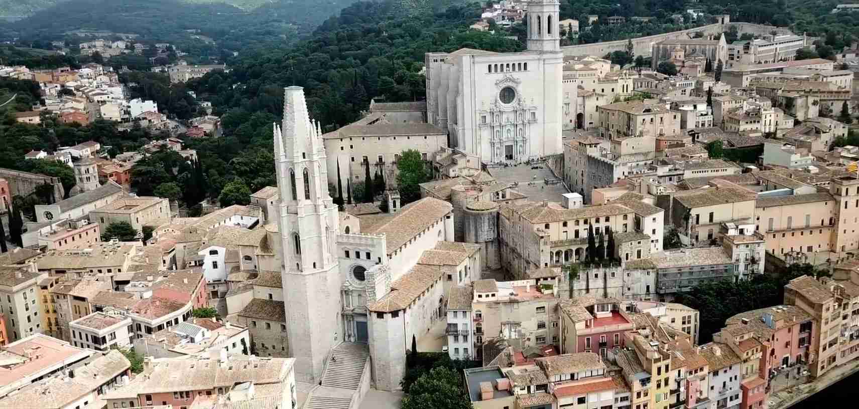
Girona is a palimpsest. Stand at any point in its old town and you are standing on Roman stone, medieval stone, and modern stone simultaneously, each era having written itself over the previous without entirely erasing it. The Força Vella — the hilltop Roman walled enclosure that forms the city’s irreducible core — contains, within its compressed perimeter, a Roman road, a Gothic cathedral, Romanesque baths, and the medieval Jewish quarter. The Call occupies the western flank of this hill: a compressed triangle of streets bounded by the Via Augusta to the east, the Roman defensive walls to the west and south, and the mixed neighbourhood of the Mercadell to the north.
The first Jewish families arrived in Girona in the ninth century, approximately 25 households settling initially near the cathedral hill in the densely built streets of the Christian ecclesiastical core. Over the eleventh century, the community migrated southward toward the Via Augusta sector, establishing itself as a recognised aljama — a self-governing community with its own communal institutions — by the twelfth century. From this point, the Call’s architecture took shape: a formal quarter coalesced along Carrer de la Força, and the aljama built the infrastructure of Jewish urban life: synagogues, a mikveh, a butcher’s shop, a hospital, and an orphanage, all within a territory that a person could cross on foot in a few minutes.
At its height, in the thirteenth and fourteenth centuries, the Call housed between 800 and 1,000 residents. Medieval Girona had a total population of perhaps 10,000 people in the 15th century, meaning the Jewish community represented roughly one tenth of the city, concentrated into a fraction of its footprint. This density was extraordinary: vertical multi-story houses, ground-floor workshops, shared courtyards, and a street system designed to pack community life into a bounded territory. The density produced the architectural form the Call still displays — a compressed, vertical, layered urbanism built in stone and governed by the need to fit everything within rigid outer limits.
Girona’s Call was the second most important Sephardic community in Catalonia during the Middle Ages, after the Jewish quarter of Barcelona. Its significance derived not only from its size but from its intellectual life: the 12th and 13th centuries were its golden age, when scholars such as Nahmanides transformed the Call into the foremost centre of Kabbalistic study in the Iberian peninsula. This intellectual distinction is inseparable from the physical spaces that housed it — the libraries, courtyards, and residential rooms where knowledge circulated and was codified.
The final century of the Call’s Jewish life was a history of progressive physical reduction. The pogrom of 1391 damaged buildings and drastically reduced the population through death and forced conversion. The formal enclosure of 1415 — in which the community was confined behind a newly built wall to a smaller territory — froze a particular moment of urban form, transforming the Call’s organic street network into a permanent historical artefact. After the expulsion of 1492, the buildings passed into Christian ownership, were repurposed and subdivided, and some alleys were walled up. The Call ceased to be a Jewish quarter, but its stone skeleton endured, awaiting the modern scholarship and archaeology that have progressively recovered what it contains.
Roman Foundations: The Via Augusta and the Força Vella
From Roman Road to Jewish Spine: Carrer de la Força
Carrer de la Força is not simply the main street of the Jewish Call — it is one of the oldest continuously occupied urban corridors in the western Mediterranean. The street follows the alignment of the Via Augusta, the Roman road that was the longest engineered highway in Iberia, connecting the Pyrenees to Cádiz. The Romans built their city of Gerunda in the first century BCE astride this road, and the Força Vella — the walled town — was oriented around its north-south passage through the hilltop site. The road entered the walled town through the southern Porta Onnare (the Onyar Gate) and exited northward through the Porta Villanova. Carrer de la Força, running between these two ancient gateways, is the direct descendant of this Roman alignment.
When the Jewish community consolidated in this sector during the eleventh century, the Roman road was already more than a thousand years old. Its paving had been overlaid and worn and relaid across centuries; Roman masonry had been incorporated into the flanking walls as building material. But the alignment itself never changed. The geometry of the Via Augusta determined where the Call could grow and how its principal axis was oriented. Carrer de la Força became the commercial heart of the quarter: the ground floors of buildings along this street housed workshops and small shops, creating an urban mercantile environment that was continuous with the mixed commercial life of the Força Vella above it. In the 14th century, the Call was described as a place where “both Jews and Christians had their homes and workshops,” and this mixed-use character was expressed directly in the architecture of Carrer de la Força, where the boundaries between Jewish and Christian commercial life were architectural as much as legal.
The name “Força” in Carrer de la Força preserves the memory of the Roman-period fortification. The word derives from the Latin “fortia” — strength, or fortified place — and the street name records not just the Roman road but the defensive character of the entire hilltop complex within which it ran. Walking Carrer de la Força today means walking a route in continuous use since the city’s Roman foundation: the buildings flanking the street represent multiple phases of construction superimposed on that ancient alignment, from Roman-period walls surviving as foundations and lower courses, through medieval Jewish construction in the stone masonry of façades, to post-expulsion residential and commercial reuse visible in altered window openings and later-period shopfronts.
The Força Vella as Architectural Matrix
The Roman walled town provided the Call with more than its spine. It provided its container. The Roman defensive walls — built in the first century BCE and reinforced and extended through the medieval period — ran along the western and southern perimeter of the Call. These were not abstract boundaries: they were physical walls of Roman and medieval masonry, two to three metres thick, that literally formed the back walls of buildings in the Call’s western margin. Houses along this edge were built directly against the Roman circuit, their rear walls incorporating sections of the ancient defensive masonry as structural elements.
The consequence of this arrangement was that the Call could not expand westward. Its growth was constrained by an immovable Roman-period boundary, pressing the organic accretion of medieval Jewish building toward the east and north. The eastern boundary ran against the cathedral quarter — the Christian institutional core of the city — and the northern limit was formed by the houses of the Mercadell neighbourhood. Only the south-facing slope toward the Onyar River offered any flexibility, and a gate in the Roman wall on this side — known variously as the Porta Onnare, the Porta de l’Areny, and, in some periods, simply the Porta del Call — gave the community its primary controlled access point to the lower city.
The topography of the Força Vella is inseparable from the architecture it generated. The hill descends steeply westward toward the Onyar, meaning that streets running east-west within the Call are also streets that climb significantly. Streets running north-south (broadly parallel to Carrer de la Força) follow the hillside contours with gentler gradient but still involve considerable changes in level. The medieval builder’s response to this topography is everywhere visible: buildings set into the hillside use the slope as a structural resource, lower stories dug into the rock to create stable foundations; stepped passages connect levels that cannot be joined by ramps; corbelled arches bridge narrow alleys to provide additional floor space for buildings that cannot expand sideways. The result is an architecture of interlocking levels, in which the ground floor of one building is the first floor of its neighbour below — a spatial arrangement that still produces unexpected vertigo when encountered at a corner or staircase in the modern quarter.
Urban Morphology of the Call: Streets, Passages, and Organic Growth
The Logic of the Labyrinth
The Call’s street network is emphatically not planned. There is no grid, no regular block pattern, no hierarchy of wide avenues and narrow secondary lanes imposed from above. What exists is the residue of centuries of incremental construction: each building placed to take advantage of available ground, each alley formed in the gap between buildings erected without formal setback requirements, each passage cut where the need for movement between parts of the quarter demanded it. The result is the labyrinthine quality that has made the Call visually and experientially distinctive, and that gives the quarter its almost archaeological character — a place where you encounter spatial surprises at every turning because the space was never rationalised from the outside.
The primary level of the street hierarchy is Carrer de la Força itself, running north-south along the Via Augusta. This is the widest street of the quarter, the most commercially active, and the one that connected the Call to the rest of Girona via the gates at its northern and southern ends. Off Carrer de la Força, secondary streets branch west and east. The western branches lead toward the Roman wall and become progressively shorter and steeper as they hit the perimeter. The eastern branches lead toward the cathedral quarter and tend to be longer, eventually connecting the Jewish zone to the Christian streets of the Força Vella’s eastern sector.
Below the secondary streets, a third level of circulation consists of narrow passages, stepped lanes, and covered alleys that connect buildings to courtyards or link neighbouring streets at points where a normal street connection was impossible. Many of these connections were internal to building complexes rather than public passages — routes through shared courtyards, under arched openings, or via staircases built between two properties. The distinction between “public street” and “private passage” was porous in the medieval Call, and this porosity produced the layered, interpenetrating spatial quality that makes the quarter difficult to read from a plan and endlessly revealing on foot.
Carrer de Sant Llorenç and the Western Arteries
The most important secondary street is Carrer de Sant Llorenç, which runs roughly parallel to Carrer de la Força a short distance to its west. This lane is one of the narrowest in the Call, dark and often shadowed by the height of the flanking buildings, its stone walls leaning slightly inward where upper floors project on corbelled supports. The street connects the lower portion of the Bonastruc ça Porta Centre at its southern end with the upper levels of the quarter, rising steeply toward the Roman wall zone to the north and west.
Carrer de Sant Llorenç carries an additional historical charge beyond its architectural character: sections of this street were physically sealed with masonry walls for centuries — physically blocked as part of the spatial restrictions imposed on the community after 1391. The blocked portions remained sealed until 1975, when restoration work began to recover the street as a passable lane. Today, the exposed stone surfaces of the walls still show, in their texture and jointing, the distinction between medieval construction and the later blocking masonry — a stratographic record of restriction written into the fabric of the lane itself.
Further west, Carrer d’Hernández represents the most extreme compression of the Call’s street hierarchy: a passage so confined that it remains accessible from only one end, the other sealed, creating a cul-de-sac that ends in a blank wall. These walled-off channels are not architectural accidents but historical documents — they record specific moments of political and social constriction in the community’s later life. Walls were built to separate, restrict movement, and deny the Jewish community access to certain streets and buildings. The architecture of the Call is therefore also an architecture of prohibition, physically inscribed in stone and still legible in the pattern of sealed openings and blocked lanes.
The Boundaries of the Call and the Call Reduït
The Call reached its maximum spatial extent in the thirteenth and early fourteenth centuries, occupying a roughly triangular area bounded by the Roman wall to the west and south, the cathedral quarter to the east, and the Mercadell houses to the north. Within this territory, the aljama managed its own affairs and paid taxes directly to the king of Catalonia, operating with substantial internal autonomy within the physical boundaries the city and its own tradition had established.
The decisive architectural reduction came in 1415, following the Disputation of Tortosa, when the municipal authorities physically walled off a portion of the existing Call, confining the surviving Jewish community to a smaller enclosure — the call reduït, or reduced call. The wall ran along the western side of Carrer de la Força, forcing the community out of the buildings and streets on that side of the main artery and concentrating them in the eastern sector behind the new wall. This compression produced an architectural consequence: expelled from their earlier places of worship on the western side of the street, the aljama established a new synagogue complex in the reduced call, on land formally acquired in 1434.
The boundary of the call reduït is legible in the fabric of the quarter today. Sealed windows facing Carrer de la Força from buildings on the western side record the prohibition — after 1415, those openings were blocked with masonry to prevent visual or social contact between the enclosed community and the main street. The 1415 wall itself no longer survives as a continuous recognisable structure, but its trace can be mapped through the distribution of sealed openings, surviving property boundaries, and the documentary record of which buildings fell inside or outside the reduced call.
Domestic Architecture: Stone, Verticality, and the Hidden Courtyard
Stone as the Universal Building Material
The Força Vella sits on a geological formation of grey limestone, and every building in the Call uses this material as its primary structural element. The stone is locally quarried, fine-grained, and well suited to the compression loads of multi-story masonry construction. It weathers to a warm honey-yellow that is the characteristic visual register of Girona’s old town — the colour that saturates in afternoon light and gives the quarter its cinematographic intensity.
In the Call, limestone is used without display. There is very little of the cut-stone decoration that marks the great civic and religious buildings of medieval Girona — the Cathedral, the Collegiate Church of Sant Feliu, the Monastery of Sant Pere de Galligants. The domestic architecture of the quarter is utilitarian: load-bearing limestone walls, flat or very slightly pointed arch openings for doorways and windows, corbelled projections where buildings needed to extend sideways over narrow lanes. The quality of stonework varies considerably between buildings and between building phases, reflecting the economic realities of the occupants. Some houses show neat courses of dressed stone in their lower levels with rougher rubble work above, suggesting that construction was carried out in stages as resources permitted — a common pattern in medieval domestic building where the priorities were structural security at foundation level and economical closure above.
Where stone is supplemented, brick appears in some later phase constructions. The Bonastruc ça Porta Centre complex includes sections where early restoration work in the 1980s revealed what sources describe as “handsome brick architecture” in portions of the 15th-century building phase. This use of brick in the final Jewish-period construction at the site represents a modulation of the stone-dominant tradition: by the 15th century, the reduced and economically constrained community was building with materials available and affordable rather than with the more ambitious stone construction programmes of the 12th and 13th centuries.
Vertical Living: The Medieval Jewish House in the Call
Medieval Jewish houses in the Call are vertical rather than horizontal. This is a direct consequence of the compressed urban territory available: with fixed outer boundaries and a dense existing street network, the only direction for growth was upward. Ground floors were devoted to commercial and craft activity — workshops, small shops, the storage of goods and raw materials — while the residential quarters occupied the first and second floors above. This vertical zoning of function is a characteristic feature of medieval urban domestic architecture across Europe, but in the Call it is particularly pronounced because the ground-floor commercial zone faced not a wide public street but a narrow passage that limited the scale and visibility of any trading operation. The workshop and the home were vertically stacked in the same building, separated by a flight of stairs rather than by the horizontal distance that distinguished commercial and residential zones in more spaciously planned cities.
Upper floors of Call buildings were accessed via internal stone staircases or external stone steps built against the rear walls of courtyard spaces. In many buildings, upper floors extended over the narrow alleys on corbelled supports, effectively bridging the lane and creating a covered passage at ground level — an architectural device that expanded upper-floor area while shading the lane below. These corbelled projections are visible in several surviving examples in the quarter, their stone brackets worn and sometimes cracked but structurally intact, still supporting the additional floor space they were built to carry.
The building materials and construction techniques of the Call’s domestic architecture also record social stratification within the community. The houses of wealthy merchants, scholars, and community leaders were built with better-dressed stone, wider plan dimensions, and larger courtyards than the modest dwellings of artisans and poorer residents. The house associated with Nahmanides on Carrer Cundaro, and the building identified as the House of Lleó Avinay (the last head of the aljama) on Carrer de Sant Llorenç, would have occupied the upper tier of this social architecture — wider lots, better stone, more generous internal organization than the compressed median dwellings of the quarter.
Courtyards and Hidden Spaces: The Pati dels Rabins and Beyond
Behind the street façades of the Call lies a world of enclosed courtyards — interior spaces that provided light, air, and social gathering for residents whose street frontages were too narrow to serve these functions. The courtyard is the critical spatial unit of the Call’s domestic architecture: the place where private life was organised, where children played, where water was stored in cisterns, and where the informal business of the community happened at a domestic scale invisible from the public street.
The most architecturally distinctive surviving courtyard is the Pati dels Rabins (Courtyard of the Rabbis), part of the Bonastruc ça Porta Centre complex. This courtyard is characterised by notable brightness — a quality that contrasts dramatically with the shadowed narrowness of the surrounding lanes. The brightness results from the courtyard’s careful orientation and the height-to-width ratio of its enclosing walls, which allow sunlight to penetrate for a longer portion of the day than the compressed street sections around it. This deliberate management of light in a dense urban environment is characteristic of skilled medieval builders working with limited space: the courtyard was not just a functional void between buildings but an architecturally considered space, designed to provide the luminosity and openness that the streets outside could not offer.
The Pati de les Dones (Women’s Courtyard) at the Bonastruc ça Porta Centre provides a second surviving example of this spatial type. Its name preserves a gendered association with the domestic and religious activities that took place in shared courtyard spaces — the separation of spaces by gender within the Jewish domestic and communal built environment is a recurring feature of medieval Jewish architecture, reflected in the organization of synagogue interiors as well as in domestic courtyard use.
Underground infrastructure adds a further dimension to the hidden architecture of the Call’s courtyards. Medieval cities in water-limited environments relied on cisterns to store rainwater runoff from roofs and courtyards. The cistern excavated in the main Bonastruc ça Porta courtyard — still visible as an archaeological feature — adds a subterranean layer to the vertical reading of the quarter’s architecture. The cistern is connected structurally to the mikveh remains revealed by the 2014–2015 excavations, together forming a complex of water-management infrastructure that was central to both the practical and ritual life of the community.
Religious Architecture: The Three Synagogues of Girona
Girona’s Jewish community maintained three synagogues at different periods of its medieval history, each reflecting a distinct phase in the community’s spatial and institutional evolution. No complete synagogue structure survives above ground in the original form, but documentary evidence, archaeological investigation, and the preserved fabric of the Bonastruc ça Porta Centre together provide a substantial architectural picture of what these buildings were and where they stood.
The First Synagogue: Origins Near the Cathedral
The first recorded Jewish settlement in Girona placed the initial 25 families in the area around the cathedral — in the dense network of streets and small squares that formed the Christian ecclesiastical core of the Força Vella. This initial phase of settlement, concentrated in the ninth century, established itself near the north end of the walled town, and it was in this area that the community built its first synagogue. The evidence for this is primarily documentary and epigraphic: references in Hebrew inscriptions and communal records to a “great synagogue” that stood in this northern precinct. A stone bearing an inscription associated with the Great Synagogue of Girona, dated to the 14th century, is preserved in the Museum of Jewish History, providing a material link to this early institutional presence.
The precise location of the first synagogue within the cathedral precinct remains archaeologically unconfirmed. Its existence in this area is consistent with the general pattern of early Jewish settlement in Catalonian cities, where the initial community established itself near the administrative and commercial centre before later concentration in a formally designated quarter. The first synagogue, in this reading, predates the formal Call by at least two centuries, representing the architectural beginning of a community that would not coalesce into its characteristic urban form until the twelfth century.
The Second Synagogue: The Kabbalistic Heart
As the community consolidated along Carrer de la Força during the twelfth and thirteenth centuries, a second synagogue was built on the western side of the street, in the middle section of the Call near what are now the Cathedral steps. This synagogue — constructed in the 12th to 13th century and substantially renovated in the mid-14th century, largely funded by the Taroç family — served the community during its most intellectually active period: the era when Nahmanides and the Kabbalistic circle that formed around him made Girona famous throughout the Jewish world.
The synagogue on Carrer de Sant Llorenç served as the primary place of worship and learning during the community’s peak. Scholars including Azriel of Girona (a student of Isaac the Blind and one of the most important early systematisers of Kabbalah) and members of Nahmanides’s teaching circle used this building and its attached study spaces as the headquarters of a mystical school whose influence spread across Iberia and into Provence and the Rhineland. The 1391 pogrom desecrated and looted the building, and the subsequent century saw it closed, restored by royal order in 1415, and then permanently closed again in 1420 — a sequence of architectural violation and recovery that mapped directly onto the political fortunes of the community.
The Third Synagogue and the Bonastruc ça Porta Centre
The third and final synagogue of Girona’s Jewish community was established after the 1415 enclosure. Confined to the eastern sector of the former Call, the aljama formally acquired a plot of land in November 1434 — purchasing, as the purchase documents record, “gardens and patios described as ruined” — and constructed a new synagogue complex on that ground. The community’s leaders at the time of the purchase were Bonastruc des Mestre, Astruc Aninay, and Bonastruc Jucef. The complex stood at what is now 8 Carrer de la Força (the current address of the Bonastruc ça Porta Centre), and it served the community until 1492, when the Alhambra Decree required the expulsion of all Jews from the crowns of Castile and Aragon.
On July 10, 1492, the third synagogue was sold by the Jewish community to the canons of Girona Cathedral for 300 pounds — an act of financial necessity and communal dissolution that closed a chapter of religious architecture stretching back nearly six centuries. The low price reflected the pressure of a community selling under an enforced departure deadline, liquidating centuries of architectural investment for a sum that would fund an uncertain exile.
After the sale, the synagogue building passed into private hands and was adapted for domestic use. Its religious identity was obscured by the accumulated layers of residential conversion over the following centuries. It survived as a private property until the 1980s, when the City of Girona undertook the first phase of restoration, recovering the characteristic brick architecture of the 15th-century construction phase and establishing the complex as a heritage site. The Museum of Jewish History opened within the complex in 2000, and the Institut d’Estudis Nahmànides was founded in 1997 to pursue research and education on the community’s history. Together, these institutions occupy the most architecturally layered building in the Call: a 15th-century synagogue on a site associated with Nahmanides’s yeshiva, in a complex that incorporates Roman, medieval Jewish, post-expulsion domestic, and modern heritage phases in a single stratigraphic sequence.
The Mikveh of the Girona Call: Ritual Architecture Recovered
The mikveh — the ritual bath required by Jewish law for purification — is one of the most architecturally essential components of any Jewish community. Its construction requirements are determined as much by religious law as by building convention: the bath must contain a minimum volume of naturally collected or flowing water (rainwater or spring water, not drawn water), and the basin must permit full immersion. The physical form of the mikveh is therefore standardised across geography and period, making it a distinctive building type with recognisable structural features wherever it appears.
The 2014–2015 Archaeological Discovery
In 2014 and 2015, archaeological excavations at the Bonastruc ça Porta Centre — organised by Girona City Council as part of an ongoing programme to document the community’s physical heritage — uncovered structural remains associated with a mikveh connected to the third synagogue complex. These excavations produced the most architecturally significant new evidence about the Call’s built environment to emerge in decades.
The structures revealed allow a partial reconstruction of the mikveh’s spatial organisation. The facility was entered through a door that led to a hall and then to a changing room with tiled flooring — a spatial sequence designed to maintain the ritual purity of the bathing space by separating it from the street and providing a transitional zone for preparation. From the changing room, access to the bath itself was gained by stepping over a threshold and descending via a landing made of stone slabs, leading to the bathing pool below. This architectural sequence — entrance, hall, antechamber, pool — is consistent with mikveh structures documented at other medieval European Jewish sites. The famous mikveh at Besalú, approximately 50 kilometres northwest of Girona and one of only three medieval Jewish ritual baths preserved in Europe, provides the closest regional parallel for understanding what the Girona mikveh would have looked like in its complete form.
The excavated mikveh dates to the 15th century and was integral to the third synagogue complex established after 1434. Earlier sources note an 11th-century mikveh elsewhere in the quarter — a structure that would have served the community during the period of the first and second synagogues — but no remains of this earlier bath have been archaeologically confirmed at the Bonastruc ça Porta site. The 15th-century mikveh was transformed into a cistern after the expulsion of 1492, its religious function deliberately or inadvertently obscured as the building passed into non-Jewish use. This transformation is what preserved its structural shell: reused as a water storage facility, the mikveh escaped the more radical interventions that might otherwise have destroyed it, surviving embedded in the courtyard’s fabric until the 2014–2015 excavations made it visible again.
Communal Architecture of the Aljama: Hospital, Bathhouse, and Market
The Call’s architecture extended beyond domestic and religious buildings to encompass the full institutional infrastructure of a self-governing urban community. The aljama administered a network of communal services housed in dedicated buildings distributed along and near Carrer de la Força. This institutional layer of the Call’s architecture represents a form of community-organised urban planning operating within the organic street network: specific buildings assigned to specific functions, creating a spatial map of communal life in which religious, social, and economic activities all had their designated places.
Hospital, Orphanage, and the Communal Services
Distributed around the main artery of Carrer de la Força, the communal institutions of the Call included a hospital for the care of the sick, an orphanage, and a house of charity for the poor. These buildings occupied the ground floors of multi-story structures along the street, their institutional functions coexisting with the domestic and commercial activity that filled every storey of every building in the compressed quarter. The co-location of hospital, orphanage, and charity house with domestic and commercial life on a single street is not a planning failure but a deliberate expression of the integrated character of medieval Jewish communal organisation: the aljama governed the whole of community life, and its buildings were distributed across the quarter’s fabric rather than segregated into a separate institutional zone.
The kosher butcher’s shop — an architectural requirement for any halakhic Jewish community, since the slaughter of animals and the preparation of meat were governed by strict religious law requiring designated facilities — was possibly located in the same building complex as the third synagogue on Carrer de la Força. The building at what is now number 10 on this street is identified in some sources as having housed both the synagogue and the butcher’s operation. This combination reflects the multi-functional character of communal buildings in the reduced Call: a community compressed into a smaller territory concentrated its essential institutional functions into fewer, larger buildings rather than distributing them across the broader quarter it no longer occupied.
La Pabordia: The Communal Baths
The Pabordia — a complex of buildings on the right side of Carrer de la Força, accessible via the staircase known as the Pujada de la Mare de Déu de la Pera — housed the community’s public baths between the 13th and 14th centuries. This structure represents the non-ritual bathing infrastructure of the Call, distinct from the mikveh’s religious purification function. The Pabordia’s staircase, climbing from Carrer de la Força to the upper level of the quarter, is one of the vertical circulation routes that characterise the Call’s hillside topography and connect the main street to the buildings and spaces hidden on higher ground behind the street façades.
The Jewish market occupied one end of the Via Augusta sector of the Call, completing the picture of a self-sufficient communal economy operating within the quarter’s walls. Food preparation (the butcher), purification (the mikveh), healthcare (the hospital), education (the yeshiva), worship (the synagogue), and bathing (the Pabordia) all functioned within a walking distance measured in tens of metres: the Call was not merely a residential neighbourhood but a complete urban organism, with the institutional infrastructure to sustain a community that was required by law and circumstance to be largely self-contained.
Nahmanides and the Architecture of Kabbalistic Learning
The greatest intellectual figure produced by Girona’s Jewish community was Moshe ben Nahman Girondi — known in Catalan as Bonastruc ça Porta, meaning literally “good fortune near the gate,” and in Hebrew scholarship as the Ramban. Born in Girona in 1194, he lived in the Call’s streets for most of his seven decades, departing only after the 1263 Barcelona Disputation made his continued presence in Catalonia politically untenable. He died in the Land of Israel around 1270, never returning to the city that bore his name in the Jewish world’s honorific map of places.
Nahmanides was not merely a resident of the Call — he was its intellectual architect. As chief rabbi of Catalonia, physician, philosopher, kabbalist, and biblical commentator, he shaped the community’s identity and its relationship to the wider currents of medieval Jewish thought. Approximately fifty of his written works survive, addressing Talmudic interpretation, the rites of mourning, the doctrine of transmigration of souls, and the nature of mystical experience. His writing specifically sought to mediate between the rationalist philosophical tradition associated with Maimonides and the mystical currents of the Kabbalistic school — a synthesis he pursued by proposing a detailed programme for how the study of sciences should be structured according to the age of students and integrated with spiritual life.
The House on Carrer Cundaro and the Yeshiva Site
Nahmanides’s house stood on a corner of Carrer Cundaro, one of the short passages branching west off Carrer de la Força. The corner location — identifiable from documentary sources — placed it at the intersection of two circulation routes in the quarter, a position consistent with the residence of a prominent community leader who received visitors and conducted scholarly business from his home. Medieval Jewish houses of this type functioned as multivalent spaces: domestic residence, scholarly study, reception of students and petitioners, and sometimes small-scale commercial activity on the ground floor. The distinction between the scholar’s study and his living quarters was spatial but not absolute — the same rooms served multiple functions at different times of day.
The site of Nahmanides’s yeshiva is associated with the ground now occupied by the Bonastruc ça Porta Centre. This association explains the name chosen for the Centre when it was established: the building’s primary cultural significance derives not merely from the 15th-century synagogue it housed in its final Jewish phase, but from its connection to the 13th-century master whose school made Girona famous throughout the Jewish world. The Institut d’Estudis Nahmànides, founded within the Centre in 1997, explicitly revives this intellectual tradition, conducting academic research, educational programmes, international scholarly conferences, and Hebrew language instruction at the site where the original Ramban is believed to have taught.
The Kabbalistic Circle and the Architecture of Knowledge
Nahmanides was the central figure in a Kabbalistic circle that included Azriel of Girona — a student of Isaac the Blind and one of the most important early systematisers of Kabbalah — and several other scholars whose names appear in the records of the Call. This circle transformed the quarter’s intellectual geography: specific buildings became associated with specific teachers, students moved between houses to study, and the communal library housed manuscripts of Kabbalistic works that circulated across Iberia and into Provence and the Rhineland.
The architecture that hosted this intellectual activity was not distinguished externally from the ordinary domestic and communal fabric of the Call. There were no dedicated academic buildings, no library towers, no lecture halls in a formal institutional sense. Learning happened in courtyards, in upstairs rooms, in the spaces adjacent to the synagogue, and in the private houses of scholars. This integration of the architecture of learning into the fabric of everyday life is characteristic of medieval Jewish intellectual culture, which embedded scholarly activity in the domestic and communal spaces of the community rather than separating it into autonomous institutional buildings.
The 1263 Disputation of Barcelona — in which Nahmanides debated Pablo Christiani, a converted Jew who had challenged the community to a public theological contest, before King James I of Aragon and a panel of Dominican friars — briefly brought the Call’s intellectual culture into direct contact with royal Iberian power. Nahmanides acquitted himself brilliantly enough that the king, who maintained personal ties of friendship with him, initially imposed only a modest penalty of two years’ exile. Dominican pressure escalated this to permanent banishment. The departure of Nahmanides from Girona was an architectural event as much as a personal tragedy: the house on Carrer Cundaro became simply a house, the yeshiva site lost its animating figure, and the Kabbalistic circle of the 13th century began its long dispersal into other cities and other traditions.
Architecture of Loss: The Pogrom, the Enclosure, and the Expulsion
The Pogrom of August 1391 and the Tower of Gironella
On the night of August 10, 1391 — the feast of San Lorenzo — anti-Jewish riots swept through the Call. The assault followed a wave of pogroms that had begun in Seville earlier that summer and spread rapidly northward through the Crown of Aragon. In Girona, the attack was sudden and violent: buildings were burned, property was seized, and residents who refused conversion were killed. Scholars and rabbis, artisans and students, shopkeepers and the head of the aljama — more than a hundred people fled uphill toward the highest point of the Força Vella, seeking refuge in the Tower of Gironella.
The Tower of Gironella is a Roman defensive tower at the northern apex of the city’s wall circuit, at the highest point of the old town. Its thick stone walls, originally built in the first century BCE and incorporated into the medieval defensive system, provided the physical protection that the Jewish community needed in its moment of extreme vulnerability. The community crowded into this single structure and remained there for 17 weeks, under the nominal protection of royal soldiers whose commitment to that protection was not always consistent. During the weeks of confinement, Christian friars and parishioners came to the tower daily to press the occupants toward conversion. The fires that had consumed buildings in the Call below were visible from the tower’s windows.
The physical damage to the Call from the 1391 attack was substantial. Buildings in the western sector — the commercially active zone along Carrer de la Força — were burned and looted. The community that emerged from the tower’s shelter was reduced in number, economically devastated, and facing intensifying social hostility. The architectural consequence of 1391 was not immediate demolition but progressive abandonment: damaged buildings were not fully rebuilt, communal institutions that had served a larger population were not maintained, and the spatial generosity of the 13th-century Call began its permanent contraction.
The 1415 Enclosure: Architecture as Instrument of Confinement
The decisive architectural event of the Call’s final century was the construction of a wall that physically divided the existing quarter and confined the surviving Jewish community to a reduced enclosure. Following the Disputation of Tortosa (1413–1414) — a prolonged forced theological debate that resulted in mass conversions and the further erosion of Jewish legal standing in Catalonia — the municipal authorities of Girona proceeded in 1415 to implement a formal spatial segregation. The wall was built along the western side of Carrer de la Força, separating the community from the buildings and streets it had previously occupied on that side of the street.
This act of architectural confinement was systematic. Windows and doors facing Carrer de la Força from the western buildings were physically sealed — blocked with masonry to prevent any visual or social communication between the enclosed community and the main street outside. Carrer de Sant Llorenç, whose sections lay at the boundary of the reduced call, was partially blocked to restrict movement. Communal institutions on the western side of the new wall became inaccessible. The community was required to build new institutional infrastructure in the compressed eastern territory it still occupied, leading directly to the 1434 acquisition of land and the construction of the third synagogue complex.
The 1415 wall no longer survives as a continuous visible structure. But its trace endures in the alignment of later property boundaries, in the sealed openings visible on surviving façades, and in the historical record of which buildings fell inside or outside the call reduït. Reading the wall’s former line through the fabric of the current quarter is an exercise in forensic architectural history: the gaps, sealed openings, and boundary alignments that survive in the stone tell the story of a community physically written out of its own neighbourhood.
The 1492 Expulsion and the Architecture of Departure
The Alhambra Decree of March 31, 1492 — issued by Ferdinand II and Isabella I — gave the Jewish communities of Castile and Aragon four months to convert to Christianity or leave the kingdoms. Girona’s community chose departure. On July 10, 1492, the final act of communal dissolution was formally recorded: the third synagogue was sold to the canons of Girona Cathedral for 300 pounds. The sale price was low, reflecting the reality of a community liquidating under time pressure, forced to convert centuries of architectural investment into cash for an uncertain exile.
The buildings of the Call did not vanish — stone is durable — but they changed hands and purpose. The synagogue became a private residence. Other buildings were absorbed into Christian households. The communal infrastructure ceased its functions. The walled-up streets remained walled up. Some windows stayed sealed. And the Jewish cemetery on Montjuïc hill — the “Jews’ Mountain” outside the city, which the community donated in 1492 to the knight Joan de Sarriera, who had protected it during the 1391 riots — was desacralized. The tombstones, their Hebrew inscriptions recording the names, dates, and in some cases the professions of the community’s dead across several centuries, were subsequently used as building material by successive owners, scattered into the foundations and walls of later construction projects in and around the city.
This dispersal of the cemetery’s stones became, paradoxically, one of the most important acts of inadvertent preservation in the history of the Call. Many tombstones were recovered over subsequent centuries — extracted from buildings where they had been reused — and studied by scholars who used the Hebrew inscriptions to reconstruct genealogies, dates, and the social history of the community. Today they are displayed at the Archaeological Museum at Sant Pere de Galligants, the Romanesque monastery a short walk from the Call. The stones that marked individual deaths became, in their recovery and classification, evidence for collective life.
Adaptive Reuse: The Call After the Expulsion
The post-expulsion history of the Call’s architecture is a history of slow transformation through reuse. Stone buildings do not simply disappear; they are reoccupied, subdivided, refaced, and altered to serve new functions. The Call’s buildings, passing from Jewish to Christian ownership in 1492, underwent exactly this process over the following centuries, accumulating new layers of use that obscured but did not erase the medieval Jewish fabric beneath.
The most significant adaptive reuse was that of the synagogue complex at what is now the Bonastruc ça Porta Centre. After the sale to the cathedral canons in July 1492, the building was eventually passed to private owners and operated as a domestic residence. Internal walls were added, windows altered, the courtyard spaces reduced and reorganised. The building’s identity as a synagogue became invisible beneath the accumulated changes of residential use, surviving as private property until the 1980s, when the City of Girona acquired the complex and undertook the first phase of architectural restoration.
The 1980s restoration work recovered key elements of the 15th-century construction — including the characteristic brick architecture noted in contemporary descriptions — and established the spatial framework that the current museum now occupies. The star of David inlaid in the courtyard floor is a modern installation, but it marks the location of the courtyard cistern and, immediately below, the mikveh structures that the 2014–2015 excavations would subsequently reveal.
Elsewhere in the Call, the process of adaptive reuse was less orderly. Some alleys were incorporated into adjacent properties, their surface area absorbed into expanded courtyards or cellars. Carrer de Sant Llorenç and other blocked passages remained sealed. The walled-up streets became architectural ghosts — detectable only through the pattern of walls that lined a former passage, closed at one or both ends, and decipherable only to those who knew what to look for. When restoration and partial clearance work began in 1975, the re-emergence of these blocked passages was one of the most evocative moments in the modern rediscovery of the Call: sealed for nearly five centuries, the lanes reopened to reveal surfaces preserved in the condition of their last sealing.
Conservation, Archaeology, and Heritage Recovery in the Girona Call
The recovery of the Call as a heritage site has been a gradual and ongoing process, beginning with the scholarly interest of the mid-20th century and accelerating through the institutional developments of the 1980s, 1990s, and 2000s. Today, the quarter is managed through the Patronat Call de Girona, the municipal body that oversees the Museum of Jewish History, the Bonastruc ça Porta Centre, and the archaeological programme associated with the site.
The Museum of Jewish History
The Museu d’Història dels Jueus opened at the Bonastruc ça Porta Centre in 2000, occupying the building that in the 15th century housed the last synagogue and communal spaces of Girona’s Jewish community. The museum’s collections focus on the archaeological and documentary material of medieval Catalan Jewish communities, using examples from Girona’s own heritage wherever possible. Exhibits document the calendar and customs of Jewish religious life, the internal governance of the aljama, the role of the community in the intellectual life of medieval Catalonia (particularly its contributions to medicine, astronomy, and philosophy), and the successive crises — pogrom, enclosure, expulsion — that ended it. The museum holds funerary slabs with Hebrew inscriptions, a ceramic vessel from the 14th century, medieval Jewish garments, and documents including what sources identify as a copy of the original expulsion edict. Entering through the Bonastruc ça Porta Centre courtyard, with its star of David floor mosaic and the visible remains of the excavated cistern and mikveh, provides the fullest architectural experience of the Call’s final Jewish-period built environment.
The Archaeological Programme
The archaeological record of the Call is not complete, and each excavation campaign adds new material and complicates established narratives. The city council has consistently organised excavations at the Bonastruc ça Porta Centre site, recognising that the building’s complex stratigraphy — Roman, early medieval Jewish, 13th-century community peak, 15th-century reduced Call, post-expulsion domestic, modern heritage — preserves evidence at multiple levels that surface investigation cannot access. The 2014–2015 campaigns were the most productive in recent decades, their discovery of the mikveh remains representing a major addition to the architectural record of the site.
The recovery of tombstones from Montjuïc and from buildings throughout the Girona area represents a separate strand of the programme. Successive construction campaigns have yielded inscribed stones that are now catalogued, translated, and displayed. The collection in the Archaeological Museum at Sant Pere de Galligants constitutes one of the most substantial bodies of medieval Jewish epigraphy in Iberia, offering direct access to the names, dates, and sometimes the professions of the community’s dead across several centuries. The monastery that houses these stones — its Romanesque cloister dating to the 12th century, its octagonal bell tower one of the finest in Catalonia — sits within sight of the Call, less than five minutes’ walk from Carrer de la Força.
Key Architectural Sites to Explore in Girona’s Jewish Call
The Call rewards slow, attentive walking. Its architectural significance is not concentrated in a single monument but distributed across a network of streets, passages, courtyards, and building façades that together constitute the experience of the medieval Jewish quarter. The sites below represent the most architecturally significant locations within the quarter and its immediate surroundings.
Carrer de la Força: The Roman-Jewish Spine
Carrer de la Força is both the Via Augusta and the commercial heart of the medieval Jewish quarter: walking it from south to north is to walk a route in continuous use for more than 2,000 years. The buildings flanking the street represent multiple phases of construction — Roman-period walls survive as foundations and lower courses in some buildings; medieval Jewish construction is visible in the stone masonry of façades and in corbelled projections over the lane; post-expulsion residential and commercial reuse is recorded in altered window openings and later-period façade treatments. The Museum of Jewish History (Bonastruc ça Porta Centre) stands at number 8, its entrance courtyard marking the site of the third synagogue and the associated mikveh, yeshiva, and communal spaces of the aljama’s final half-century.
The Bonastruc ça Porta Centre: Courtyards and Excavated Spaces
The Bonastruc ça Porta Centre is the architectural centrepiece of the Call. Entered through a gateway from Carrer de la Força, the complex opens into a sequence of courtyards and garden spaces that reveal the multi-level organisation of the 15th-century synagogue complex. The star of David mosaic in the main courtyard floor is a modern installation, but the courtyard’s spatial character — its notable brightness relative to the shadowed lanes outside, its stone paving, its cistern remains and mikveh excavations — is authentically medieval in its spatial logic. The Pati dels Rabins and the garden spaces beyond are accessible within the museum complex, offering the most concentrated experience of enclosed Jewish domestic-communal space in the quarter. The Institut d’Estudis Nahmànides, located within the same complex, maintains a specialised library and continues the academic programme initiated in 1997.
Carrer de Sant Llorenç: The Sealed Lane Reopened
Carrer de Sant Llorenç is the most visually arresting passage in the Call: a narrow lane running parallel to Carrer de la Força, its walls leaning slightly overhead where upper floors project on corbelled supports, its paving stones worn smooth by centuries of foot traffic. Sealed for centuries and reopened partially in 1975, the street now allows passage through its most evocative section, its stone surfaces preserving the texture of their medieval construction. The House of Lleó Avinay — associated with the last head of the aljama — stands on this street, its stone façade a surviving example of late medieval Jewish domestic architecture in the quarter. The narrowness of the lane, the height of the flanking buildings, and the sudden patches of light where the walls draw back create the experiential compression that characterises the Call at its most spatially intense.
Placeta de l’Institut Vell and the Canonja Vella
Near the upper end of Carrer de la Força, the Placeta de l’Institut Vell concentrates several medieval buildings from the Jewish period. The most significant is the Canonja Vella — a 12th-century communal building that predates the formal call reduït by three centuries. Inside the Canonja Vella, incorporated into its interior walls, is a walled-up lane: a former alley, parallel to Carrer de la Força, sealed at some point in the Call’s later history and now enclosed within the building fabric. This sealed passage is one of the most direct architectural documents of the progressive spatial restriction imposed on the community — a lane that once connected parts of the quarter, silenced in stone, and preserved as structural filler in the building that grew around it.
The Tower of Gironella and the Roman Walls
The Tower of Gironella, at the highest point of the Força Vella’s northern tip and accessible via the city walls walkway, combines Roman and medieval significance in a single structure. Its walls, originally built in the first century BCE, are the oldest surviving masonry in Girona, and their role as the refuge of more than a hundred Jewish residents during the 17 weeks of the 1391 siege adds a layer of historical specificity that no architectural description can fully convey. The stretch of Roman defensive wall between the Gironella Tower and the southeastern sector of the circuit provides the clearest surviving visual evidence for the outer armature within which the Call was built: these Roman stones were the walls that the Call’s builders treated as their own perimeter, the boundary against which Carrer de la Força has been aligned for two thousand years. Standing at the Gironella Tower, looking south toward the Call below, the spatial logic of the entire quarter becomes legible at once: the Roman walls as container, the Via Augusta as spine, the hillside as topographic matrix, and the labyrinthine stone lanes as the organic response of a community building its world within boundaries it did not choose.
Sant Pere de Galligants: The Tombstones
A short walk north of the Call, the Monastery of Sant Pere de Galligants houses the Archaeological Museum of Girona in its 12th-century Romanesque cloister — one of the finest examples of Lombard Romanesque architecture in Catalonia, with an octagonal bell tower that is among the most elegant in the region. Within the museum, the recovered tombstones of Girona’s Jewish cemetery constitute one of the most important collections of medieval Jewish epigraphy in Iberia. Inscribed in Hebrew with names, dates, and sometimes genealogical and professional information, the tombstones were dispersed as building material after 1492 and recovered piecemeal over subsequent centuries. They arrive in the museum stripped of their original cemetery context but restored to legibility: each stone a document, each inscription a name, each name a person who lived in the Call’s stone lanes and whose architectural world this guide has tried to trace.
Frequently Asked Questions About the Architecture of Girona’s Jewish Call
What does the word “call” mean and where does it come from?
“El Call” is the Catalan term for the Jewish quarter, used exclusively in Catalonia — distinguishing Girona’s terminology from the “juderías” of Castile and the “mells” of other Iberian regions. The etymology is debated: some scholars derive it from the Latin “callum” (a narrow lane or path), while others connect it to the Hebrew “qahal” (community or congregation). Whatever its linguistic origin, the term is specific to Catalonia and carries a distinct cultural and legal meaning: a “call” was not merely a neighbourhood where Jews happened to live, but a formally recognised territorial unit with administrative standing and legal protections that had to be negotiated and defended against recurrent attempts at infringement.
How many synagogues did Girona’s Jewish community maintain?
Girona’s Jewish community maintained three synagogues across different periods of its medieval history. The first stood near the cathedral in the area of the earliest ninth-century settlement. The second was established on the western side of Carrer de la Força during the 12th and 13th centuries, serving the community during its most intellectually active period; it was substantially renovated in the 14th century by the Taroç family and was eventually closed after the 1391 pogrom and subsequent restrictions. The third was constructed after the 1415 enclosure, formally established on land acquired by the aljama in November 1434, on the site now occupied by the Bonastruc ça Porta Centre. It was sold to the canons of Girona Cathedral on July 10, 1492, for 300 pounds, as the community prepared for exile.
When was the mikveh at the Bonastruc ça Porta Centre discovered?
The mikveh connected to the third synagogue was identified during archaeological excavations at the Bonastruc ça Porta Centre in 2014 and 2015, organised by Girona City Council. The excavations uncovered the structural sequence of the bathing facility: entrance, hall, tiled changing room, and the stone-slab landing leading to the bathing pool. After the expulsion of 1492, the mikveh was converted into a cistern, obscuring its original religious function and preserving its structural shell until the archaeological campaigns made it visible again. An earlier mikveh — dated to the 11th century — is documented for the quarter during the period of the first and second synagogues, though its structural remains have not been archaeologically confirmed at the Bonastruc ça Porta site.
Why was Carrer de Sant Llorenç sealed for centuries?
The sealing of Carrer de Sant Llorenç was a direct physical consequence of the restrictions imposed on Girona’s Jewish community after the 1391 pogrom and, more formally, after the enclosure of 1415. When the community was confined to the call reduït — a smaller territory separated by a wall from the western portion of the former Call — certain streets were physically blocked to enforce the boundary and limit movement. Carrer de Sant Llorenç, lying at or near the new boundary, was among those sealed. The street remained partially walled up until 1975, when restoration work began to reopen it as part of the broader effort to recover the Call as a heritage site. Its re-emergence after nearly 500 years of closure was one of the defining moments of the quarter’s modern rediscovery.
Who was the Ramban and why is the cultural centre named after him?
Ramban is the Hebrew acronym for Rabbi Moshe ben Nahman — known in Catalan as Bonastruc ça Porta (literally “good fortune near the gate”) and in academic literature as Nahmanides. Born in Girona in 1194, he was the chief rabbi of Catalonia, one of medieval Judaism’s greatest Talmudic authorities, a founding figure of Spanish Kabbalah, physician, philosopher, and biblical commentator. He lived and taught in the Call for most of his life, his house on Carrer Cundaro and his yeshiva on the site now occupied by the Bonastruc ça Porta Centre. Forced into exile after the 1263 Disputation of Barcelona, he died in the Land of Israel around 1270. The centre named after him represents the reactivation of the intellectual tradition he embodied: the Institut d’Estudis Nahmànides, founded within the centre in 1997, conducts research, education, and international scholarly events on the ground where the Ramban taught.
What role do the Roman walls play in understanding the Call’s architecture?
The Roman defensive walls of the Força Vella — built in the first century BCE and reinforced across the medieval period — formed the physical western and southern perimeter of the Call. They were not rebuilt or adapted for the Jewish community’s use but incorporated directly into its architecture: buildings along the western edge of the Call set their rear walls against the Roman circuit, using the ancient masonry as both structural support and boundary marker. The Roman walls were therefore the Call’s outer skin, determining where the community could not build and channelling its organic growth eastward and northward instead. The extent of the call reduït after 1415 was also shaped by these same walls — the community was hemmed between the Roman perimeter to the west and the new enclosure wall to the east, occupying a territory bounded by both the ancient and the newly imposed.
Where are the tombstones from the Girona Jewish cemetery kept?
The tombstones from Girona’s medieval Jewish cemetery on Montjuïc hill are preserved in the Archaeological Museum at Sant Pere de Galligants, a Romanesque monastery a short walk north of the Call. The cemetery was donated to the knight Joan de Sarriera in 1492, and subsequent owners dispersed the tombstones as building material throughout the Girona area. Recovered piecemeal over subsequent centuries, the inscribed stones — bearing Hebrew inscriptions with names, dates, and in some cases genealogical and professional details — are now catalogued, translated, and displayed, constituting one of the most significant collections of medieval Jewish epigraphy in Iberia. The Romanesque monastery that houses them, with its 12th-century cloister and distinctive octagonal bell tower, is itself one of the finest surviving examples of Lombard Romanesque architecture in Catalonia.
What is the relationship between the Call and the Força Vella?
The Força Vella is the entire Roman walled enclosure — the ancient defended hilltop town that forms the historic core of Girona, containing the Cathedral, the Arab Baths, the City History Museum, and numerous other monuments in addition to the Jewish quarter. The Call is a neighbourhood within the Força Vella: the specific sector occupied by Girona’s Jewish community, bounded by the Via Augusta to the east, the Roman defensive walls to the west and south, and the Mercadell neighbourhood to the north. The Call is thus embedded within the Roman walled town rather than adjacent to or separate from it — a community living inside an ancient defended enclosure, using the Roman walls as its own perimeter and the Roman road as its commercial spine.
How has the Call been preserved and what is its current heritage status?
The Call is managed by the Patronat Call de Girona, a municipal body that oversees the Museum of Jewish History, the Bonastruc ça Porta Centre, and the ongoing archaeological programme. The street network of the quarter is largely intact from its medieval form — the 1415 enclosure effectively fossilised the street pattern, and subsequent centuries of domestic reuse, while altering individual buildings, did not demolish the underlying urban structure. Modern conservation efforts have included the 1980s architectural restoration of the Bonastruc ça Porta building, the 1975 reopening of Carrer de Sant Llorenç, and the 2014–2015 archaeological excavations that uncovered the mikveh. The quarter functions today as both an active historic district — its streets walkable and its buildings occupied — and as a major cultural heritage site, attracting visitors to its museum collections, architectural heritage, and the ongoing scholarly work being conducted at the Institut d’Estudis Nahmànides.
What is the best time of year to explore the Call’s architecture?
The Call is architecturally rewarding in all seasons, but certain conditions favour a deeper reading of its stone fabric. Winter and early spring offer the lowest visitor volumes, quieter streets, and the slanted low-altitude light that most dramatically articulates the relief and texture of the limestone walls. The shadowed lanes of Carrer de Sant Llorenç and the western alleys are less shadowed in winter when the sun’s arc is lower, making the sealed and sealed-and-reopened wall surfaces more legible. Summer brings the intense Catalan light that saturates the warm honey-yellow of the stone to its most photogenic expression, but also the highest visitor numbers. In May, Girona holds its celebrated Temps de Flors (Season of Flowers), during which many of the old town’s historic courtyards are opened to visitors — including courtyard spaces in the Call that are not otherwise accessible — giving a rare opportunity to see the private spatial world of the quarter’s domestic architecture.