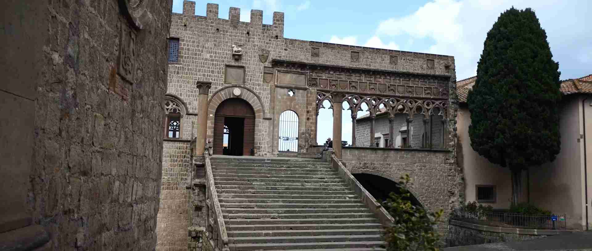
The Papal Fortress: Analyzing the Gothic Urbanism and Hydraulic Network of Viterbo’s San Pellegrino District
Hidden in the volcanic hills of northern Lazio, 80 kilometres north of Rome, Viterbo’s San Pellegrino quarter preserves one of the most complete Gothic urban landscapes to survive anywhere in Europe. Built largely between the twelfth and fourteenth centuries in dark peperino and basalt, the district encloses a sophisticated interplay of defensive towers, external staircases, bridge houses, internal courtyards, and a ramifying hydraulic infrastructure that served both the papal court and the everyday life of an entire medieval city. To walk its spine — Via San Pellegrino — is to enter an urbanism whose logic has never been superseded by later rebuilding: here the medieval city stands essentially as it was designed and inhabited.
Key Takeaways
- Europe’s largest surviving medieval quarter: The San Pellegrino district is consistently identified as the most extensive intact medieval urban quarter in Europe, preserving the full typological range of thirteenth- and fourteenth-century domestic, civic, and defensive architecture within a single continuous streetscape.
- Papal capital for 24 years: Viterbo served as the effective seat of the Roman papacy from 1257 to 1281, during which the Palazzo dei Papi was constructed on Colle del Duomo and the district of San Pellegrino reached its definitive form. The 1268–1271 conclave — 1,006 days, the longest in Church history — established the procedural rules for papal elections still in force today.
- The profferlo as social architecture: The characteristic external staircase known as the profferlo is not a decorative element but a social and functional device separating commercial ground-floor activity from residential upper floors, and the Viterbese variants encode subtle hierarchies of wealth, kin, and neighbourhood allegiance.
- A fully integrated hydraulic city: Medieval Viterbo maintained roughly ninety-nine fountains and more than twenty public wash houses (lavatoi) fed by a network of underground conduits originating from a 1268 aqueduct serving the Papal Palace. The hydraulic infrastructure was as fundamental to urban form as any church or tower.
- Peperino as identity material: Every major structural surface in San Pellegrino — walls, pavements, stairs, arches, fountain basins, tower shafts — is built in peperino, the local grey-black volcanic stone. The material unifies the district visually and carries the trace of Etruscan and Roman building traditions that preceded the medieval layer.
- Conservation without museification: Unlike many preserved medieval quarters, San Pellegrino remains a lived neighbourhood of artisans, residents, and small traders. The annual spring festival San Pellegrino in Fiore transforms the entire quarter into a floral installation, underlining that the district’s survival owes as much to continued occupation as to formal protection.
People Also Ask About Viterbo’s San Pellegrino District
What makes the San Pellegrino district architecturally significant?
The district’s significance rests on scale, integrity, and typological diversity. Unlike preserved medieval streets in Florence or Siena — where individual palaces or churches anchor scattered fragments — San Pellegrino preserves an entire urban quarter with its full complement of dwelling types, defensive structures, hydraulic elements, and public spaces in their original spatial relationships. The key architectural vocabulary of the Viterbese Gothic — profferlo, richiastro, case a ponte, tower-houses — survives not as isolated specimens but as a coherent ensemble, making the district an irreplaceable source for understanding how thirteenth-century central Italian urbanism actually functioned at the domestic scale. The uniformity of peperino construction across all building types and social levels further reinforces coherence: the quarter reads as a single designed environment rather than an accumulation of individual monuments.
What is a profferlo and why is it specific to Viterbo?
The profferlo (plural: profferli) is an external staircase of peperino stone that rises from street level to a landing at the first floor of a domestic building, providing direct access to the residential level while the ground floor remains available for commercial or artisanal use. The form appears across central Italy, but Viterbo developed distinctive regional variants: the single-flight staircase reaching a simple landing, the more elaborate double-flight form rising to an arched loggia, and the exceptional variant seen at the Palazzo degli Alessandri — a wide external balcony on massive corbels with a lowered arch below, functioning as both stairway and civic gesture. The profferlo encodes a specific social and economic logic: the ground floor belongs to trade and the street, the first floor to family and privacy. In San Pellegrino, where noble households and artisan dwellings stood in close proximity, the profferlo’s size, elaboration, and material quality served as readable indices of the occupant’s status.
How did Viterbo’s medieval hydraulic network operate?
Viterbo’s hydraulic network combined a restored Roman aqueduct infrastructure with purpose-built medieval additions. The Fontana Grande, first commissioned in 1212 and replacing an even earlier fountain documented in 1192, drew on a Roman aqueduct channel entering the city near the church of San Sisto. The specific hydraulic expansion tied to the papal period centred on an aqueduct constructed in 1268 to supply the Papal Palace on Colle del Duomo: from that elevated terminus, a system of underground conduits distributed water southward to the lower districts, including Pianoscarano. Individual neighbourhood fountains — each identified with a particular parish church and often financed collectively by local inhabitants — served as both water-collection points and social gathering spaces. The result was a network of roughly ninety-nine documented fountains and more than twenty lavatoi whose spatial distribution mirrored the social geography of the medieval city.
What role did the papacy play in shaping Viterbo’s urban form?
The twenty-four-year period of papal residency from 1257 to 1281 was directly transformative for the physical city. The construction of the Palazzo dei Papi, completed around 1266–1267 by commission of the Capitano del popolo Raniero Gatti, placed a major Gothic complex on the highest point of the city, reorienting civic topography toward Piazza San Lorenzo. The 1268 aqueduct was built specifically to supply this complex with water, creating the hydraulic infrastructure that then served the wider city. The period also accelerated construction in San Pellegrino: noble families consolidated tower-houses, the Palazzo degli Alessandri took shape in its current form in the first half of the thirteenth century, and the district’s characteristic typologies reached canonical expression. The conclave of 1268–1271, during which the citizens of Viterbo famously confined the cardinals and reduced their food rations to force a decision, made Viterbo’s name permanently synonymous with the evolution of papal electoral procedure.
Extended multi-day tours – 5+ days
Featured Lazio Marche Abruzzo Multi-Day Tour Packages
5 days
5 Day Rome Self Guided: Discover the Eternal City
- ✓ Comprehensive Lazio Marche Abruzzo tour
- ✓ Expert local guides included
- ✓ All accommodation arranged
- ✓ Transportation provided
3 days
Rome City Break – 3 Days/2 Nights
- ✓ Comprehensive Lazio Marche Abruzzo tour
- ✓ Expert local guides included
- ✓ All accommodation arranged
- ✓ Transportation provided
9 days
Paris & Rome: Magical Duo
- ✓ Comprehensive Lazio Marche Abruzzo tour
- ✓ Expert local guides included
- ✓ All accommodation arranged
- ✓ Transportation provided
4 days
The Best Of Rome: 4 Days Adventure
- ✓ Comprehensive Lazio Marche Abruzzo tour
- ✓ Expert local guides included
- ✓ All accommodation arranged
- ✓ Transportation provided
Multi-day tour packages powered by TourRadar. Prices and availability subject to change.
Introduction: The City the Popes Built
Viterbo belongs to that category of Italian city in which the medieval fabric has survived not through spectacular isolation but through sheer tenacity of occupation. Founded originally by the Etruscans and absorbed by Rome around 310 BC, the settlement passed through Lombard control in the eighth century — the Lombard king Desiderius fortified it in 773 CE — and was donated to the papacy by Matilda of Tuscany in the eleventh century. It became an independent commune and episcopal see in 1193, and over the following decades its geographical distance from Rome combined with its defensive hilltop position made it attractive to a papacy increasingly unable to operate safely in the capital.
The decisive transformation came in 1257, when Pope Alexander IV, confronted by the hostility of the Roman commune and persistent urban violence, transferred the entire papal curia to Viterbo. For twenty-four years the city served as the effective administrative and spiritual capital of the Latin Church. Eight popes resided in its newly constructed Palazzo dei Papi: Alexander IV, Urban IV, Clement IV, Gregory X, Innocent V, Adrian V, John XXI (who died in 1277 when the roof of his study collapsed), Nicholas III, and Martin IV, who finally moved on to Orvieto in 1281. The extraordinary 1,006-day conclave of 1268–1271, during which the Viterbese locked the cardinals in the Sala del Conclave and eventually removed the roof to hasten their deliberations, produced not only Pope Gregory X but the procedural template for all subsequent papal elections — the word conclave itself derives from the Latin clavis (key), commemorating the locking of the cardinals.
This period of concentrated papal patronage, political importance, and population growth drove the construction that fixed the character of the San Pellegrino district. The Gothic urbanism of the quarter — its towers, profferli, bridge houses, and fountain network — was not a gradual organic accumulation but a purposeful building campaign pursued within a relatively compressed period when Viterbo was one of the most powerful cities in Europe. The result, preserved with exceptional completeness through all subsequent centuries, constitutes an architectural document of unique density.
This analysis proceeds through three interlocking frameworks. The first addresses the topographic and material substrate: how the volcanic geology of Tuscia shaped both the form and the identity of Viterbese Gothic. The second examines the spatial logic of the district — its streets, building types, defensive systems, and social stratification as embedded in the built fabric. The third reconstructs the hydraulic network: the sequence of fountains, aqueducts, and underground conduits that transformed water management into a defining principle of urban organisation.
Topography, Geology, and the Viterbese Urban Substrate
Viterbo occupies three interlocking volcanic hills at the southern edge of the Cimini Mountains, at the transition between the tufaceous uplands of Tuscia and the Tiber valley to the east. The geological character of the territory — saturated with thermal springs, scored by river valleys, built on layers of volcanic deposit — shaped not only the form of the medieval city but its material identity. Two stones define the historic fabric: peperino and tufa.
Peperino is a grey-black leucite tuff of volcanic origin, quarried from deposits immediately around Viterbo and throughout Tuscia. Dense, durable, and easy to work with iron tools, it is simultaneously structural and decorative: in San Pellegrino the same material constitutes load-bearing walls, arch voussoirs, stair treads, fountain basins, pavement slabs, and the carved capitals of church interiors. The chromatic uniformity of peperino gives the district its distinctive tonality — a dark, almost monochrome grey that catches light differently at different hours, shifting from near-black in overcast conditions to warm silver in afternoon sun. Tufa, by contrast, is lighter and more friable; it appears in the exposed cliff faces of the valleys that bound the city’s hilltops, and in some earlier or more modest construction, contrasting with the authoritative grey of peperino in ways that mark social and temporal distinctions within the fabric.
The three hills of Viterbo — Colle del Duomo to the south-west (the ecclesiastical and papal precinct), the hill of San Francesco to the north-east, and the plateau running between them — create a topographic logic that directly shaped the urban grain. The steepest edges of the hills drop into deep valleys: the Valle del Paradosso (also called Faulle valley) to the west of San Pellegrino, and the Valle del Faul to the south. These natural barriers, which made the site defensible in the early medieval period, also defined the limits of the two principal quarters. The district of Pianoscarano occupies the lower ground to the north, in the bowl between the city walls and the San Pellegrino hill; its name may derive from the Lombard word for military units (squara), since Lombard troops used the flat ground for exercises before the area was inhabited. San Pellegrino itself occupies the ridge between the higher ground of Colle del Duomo and the descent toward the Valle del Paradosso — a position that is neither the most elevated nor the most exposed, but that commands both visual access to the papal precinct and protected connectivity to the city’s water supply systems.
The city walls, which enclosed three successive expansions between the eleventh and thirteenth centuries, bracket the historical development. Before 1095, the walls enclosed only the area around the Duomo. A second circuit, erected from 1095, extended the perimeter to include the areas of Pianoscarano and the San Sisto gate. A third expansion, documented from 1148, enclosed the Piano Scarano neighbourhood. A fourth phase from 1210 added the hill of San Francesco and the monastery of Santa Rosa. The result was an asymmetric, multi-lobed enclosure that followed the hilltop topography rather than any geometric ideal — a form that would become characteristic of Italian communal urbanism.
Crucially, San Pellegrino fell outside successive early wall circuits. Lacking the protection of city walls during the turbulent twelfth and thirteenth centuries — when factions of the Roman nobility, Holy Roman Imperial forces, and local signorial families all periodically threatened the city — its inhabitants were compelled to provide their own defensive infrastructure in the form of tower-houses. This necessity is the direct origin of the most visually distinctive element of the district’s skyline.
The Architecture of the Gothic Quarter: Building Types and Their Social Logic
The Tower-House: Defensive Architecture as Social Statement
The tower-house (casa-torre) is the dominant vertical element of the San Pellegrino skyline and the most direct expression of the district’s extra-mural defensive requirements. In the absence of city walls, aristocratic families constructed tall stone towers that served simultaneously as final refuges in factional conflict, as symbols of family power, and — through their height advantage over neighbouring buildings — as instruments of territorial control within the urban fabric. The towers of San Pellegrino rise several storeys above the domestic buildings around them, their shafts constructed in the same peperino as every other structure but distinguished by their mass, verticality, and the defensive slit windows cut into their upper sections.
The Torre Scacciaricci, rising behind Piazza San Pellegrino at the eastern end of the Palazzo degli Alessandri complex, is among the most visible and best-preserved of these tower-houses. Its four-level shaft, constructed in finely coursed peperino, dominates the visual terminus of the square from the west and reads as an integral element of the Alessandri family’s architectural complex — palace, towers, and loggia constituting a unified compound that expresses both domestic and defensive functions. The integration of tower and palace into a single compound is characteristic of the powerful families of the period: the tower provided refuge and intimidation, while the palace proper provided the residential and administrative spaces that civic status demanded.
Across the district, towers of varying dimensions and states of preservation punctuate the roofline at irregular intervals. Most are no longer at their original height — decades of legal regulation aimed at reducing factional violence led communal governments throughout central Italy to mandate the lowering of private towers — but even in their reduced state they define a vertical rhythm that distinguishes San Pellegrino from residential quarters built after the pacification of the communal period. The towers are built directly on the rock of the hill, their foundations embedded in the volcanic substrate without the need for deep excavation: the peperino bedrock itself provides bearing capacity.
The Profferlo: External Staircase as Social Mediator
If the tower-house marks the defensive and aristocratic pole of San Pellegrino’s architectural vocabulary, the profferlo marks its quotidian social pole. This external staircase, constructed in peperino and projecting from the principal façade of virtually every domestic building in the district, performs a spatial separation between commercial and residential functions that was fundamental to the economic life of the medieval city.
The ground floor of a San Pellegrino dwelling was the space of trade and craft: workshops, storerooms, and retail spaces opened directly onto the street through wide arched openings that could be shuttered at night. The profferlo rises from the street — sometimes from a raised corbelled platform, sometimes directly from the pavement — to reach a landing at first-floor level that gives access to the front door of the residential floors above. The staircase is therefore not merely a means of vertical circulation but a social threshold: the transition from the public commercial realm below to the private domestic realm above is made visible and tangible in stone.
Viterbese profferli range from the utilitarian single-flight form — a stair of twelve to fifteen steps reaching a simple landing — to highly elaborated variants that constitute architectural compositions in their own right. The most impressive example in San Pellegrino is the profferlo of the Palazzo degli Alessandri, built for one of the most powerful families in thirteenth-century Viterbo. Here the staircase ascends to a wide external balcony supported on massive corbels, with a large lowered arch beneath the balcony forming a covered passageway at street level. The composition is simultaneously functional — providing the separation of trade and residence that the typology demands — and ceremonial, declaring the Alessandri family’s status through the scale and elaboration of what is formally a domestic element. The shield-bearing heraldic motif of the family, depicting the diagonal Cross of St Andrew, is visible above the balcony, reinforcing the reading of the profferlo as civic statement.
On modest dwellings throughout the district, the profferlo is simpler but follows the same spatial logic: a single flight of peperino steps, a landing, a door. The material continuity of the type across the full social spectrum of the quarter — from the grandest palace to the narrowest artisan house — creates the formal unity of the streetscape that gives San Pellegrino its character. The profferlo is not the ornamental signature of a particular patron but the structural vocabulary of a social and economic system.
The Richiastro: Internal Courtyard and Neighbourhood Solidarity
Not all buildings in San Pellegrino face the street. A significant typological variant — the richiastro — organises domestic buildings around an internal courtyard, screened from the public street by the surrounding building mass. The richiastro is a service court shared by one or more buildings: it contains wells or cisterns, storage facilities, workspaces for activities requiring more space or privacy than the street-front shop, and in some cases minor agricultural functions such as the keeping of small animals. The term itself may derive from a local word meaning a walled enclosure or retreat.
The richiastro performs a social function complementary to the profferlo. Where the profferlo mediates between the public commerce of the street and the private residence of the upper floors, the richiastro provides a collective semi-private space shared among the households of a single compound or small neighbourhood cluster. In a district where individual dwellings were narrow — their street frontages typically two to four metres — the richiastro expanded the effective spatial envelope of domestic life by providing shared access to services that could not be accommodated within the building’s own footprint. Buildings belonging to a single extended family, or to a group of households with cooperative economic relationships, would organise themselves around a shared richiastro, connecting to it through internal passages and covered walkways that bypassed the public street entirely.
This network of internal passages and semi-private courts creates a layered spatial system in San Pellegrino: a public layer of streets and piazzas, a semi-public layer of covered passages and loggie, a semi-private layer of richiastri and internal courtyards, and a private layer of individual residential floors. The complexity of this spatial hierarchy, condensed into a district of narrow streets and dense building masses, is one of the distinctive achievements of the Viterbese Gothic and distinguishes the quarter from simpler medieval streetscapes where only the binary of street and building interior applies.
The Case a Ponte: Bridge Houses and Aerial Urbanism
The most cinematically distinctive element of San Pellegrino’s built fabric is the casa a ponte — a building or structural element that bridges two separate structures across a street or alley, connecting them at upper-floor level while leaving the street open below. Bridge houses appear throughout the district at irregular intervals, creating covered passages, visual tunnels, and structural linkages between buildings that belong to extended households or family compounds spanning both sides of a narrow street.
The case a ponte serve multiple functions. Structurally, they brace the buildings on either side of an alley against lateral movement, stabilising narrow stone walls against seismic activity and the differential settlement that affects buildings on volcanic hillsides. Functionally, they extend the floor area of residential or commercial buildings across the otherwise wasted space of a narrow alley, adding significant usable area at relatively low structural cost. Socially, they mark ownership and affiliation: a bridge house across a street declares that the families or institutions on both sides of the alley belong to the same compound, that the street between them is, in some sense, domesticated. In a neighbourhood where spatial control was inseparable from political power, the bridge house was as much a territorial gesture as a practical construction.
Some bridge houses in San Pellegrino are fully enclosed — rooms spanning the full width of the alley, with windows looking down the street in both directions. Others are more open structures: arched corbel constructions projecting from the upper floors of buildings on each side, meeting at mid-span. The narrow covered passages created by the more massive examples give certain streets within the district a claustrophobic intimacy that is part of the sensory character of the place — the sudden transition from an open piazza to a tunnel-like alley vaulted by bridge houses, then back to an open court, creates a spatial rhythm entirely specific to this type of Gothic domestic urbanism.
Piazza San Pellegrino: The Urban Set-Piece
The spatial climax of the district is Piazza San Pellegrino, a roughly trapezoidal open space at the heart of the quarter that brings together the principal civic and domestic monuments of the medieval neighbourhood in a single composition. The square is entered from Via San Pellegrino to the west and from secondary alleys to the north and south, and it terminates at the eastern end in the Palazzo degli Alessandri complex. The spatial experience of the piazza is remarkable not for its size — it is considerably smaller than the civic piazzas of Siena or Perugia — but for the homogeneity and density of its architectural content and for the sense, insistently preserved despite centuries of habitation, of having entered a space whose character belongs entirely to a single historical moment.
The church of San Pellegrino, documented from 1045 as belonging to the Abbey of Farfa and then to the Abbey of San Martino al Cimino, occupies the northern flank of the square. The original Romanesque structure was reconstructed in Gothic style, and the present facade — with its pitched roofline, circular rose window, and portal under a round arch carried on two slender columns with foliated capitals — presents a characteristic synthesis of Romanesque and Gothic elements that is typical of central Italian ecclesiastical architecture of the thirteenth and fourteenth centuries. A nineteenth-century restoration by Bishop Grasselli in 1889 introduced a Neo-Gothic character to the facade that sits uneasily with the surviving medieval elements; the pointed arch above the portal, clearly visible and of later insertion, belongs to this restoration campaign rather than to the medieval structure. The church was badly damaged during Allied bombing in World War II and has been subsequently rebuilt, but its presence as the anchor of the square’s northern side preserves the essential spatial relationship between sacred and domestic buildings that defines the medieval neighbourhood unit.
Opposite the church, the Palazzo degli Alessandri dominates the square’s southern and eastern sides. Built in the first half of the thirteenth century by the Alessandri family — one of the most powerful noble clans of communal Viterbo — the palace presents three storeys to the piazza, its ground floor arcaded on massive columns with wide arched openings that gave access to commercial and service functions, and its upper floors articulated by the large external balcony already described. Two tall towers rise from the western end of the palace, flanking its mass with vertical accents that complete the Escher-like spatial complexity of the composition. Behind and adjacent to the palace, the Torre Scacciaricci — identified as among the oldest standing monuments in the city — provides a fourth architectural layer, its shaft rising above the tower-tops of the Alessandri complex to punctuate the skyline at the quarter’s highest point.
The pavement of the piazza, laid in the same peperino and basalt as the streets and buildings around it, completes the material homogeneity of the ensemble. There is no decorative differentiation between the ground surface and the wall surfaces of the surrounding buildings; the same stone that constitutes the walls is set underfoot, so that movement through the piazza is movement within a single continuous material field. A small medieval fountain, its basin of peperino decorated in the characteristic Viterbese manner, occupies a position near the church and contributes to the hydraulic grammar of the quarter.
The Hydraulic Network: Water as Urban Infrastructure
Roman Foundations and Medieval Inheritance
The medieval hydraulic network of Viterbo was not created ex nihilo: it was built upon and extended from Roman water infrastructure whose origins long predated the medieval city. The Roman aqueduct that originally fed the Fontana Grande entered the city from the east, near the church of San Sisto, its construction attributed to the first-century consul Mummio Nigro Valerio Vigeto to supply his Villa Calvisiana. The channel followed a gravity-fed route from springs to the east, delivering water to the earliest inhabited nucleus of the city on the hill that would later become Colle del Duomo.
By the early twelfth century, the commune of Viterbo was constructing purpose-built public fountains fed by this and related water systems. The earliest documented public fountain at the site of Fontana Grande — the Fontem Sepalis, named for its flowerlike form — appears in the Liber Censuum of 1192, confirming that organised public water distribution was established before the papal period. The first major reconstruction, commissioning stonecutters Pietro and Bertoldo di Giovanni to build a new basin with a Greek cross plan in 1212, produced the foundational structure that subsequent centuries modified and enlarged. The 1279 refurbishment added the central column on which two stacked cups carry water to a finial; the 1424 campaign under Pope Martin V (Oddone Colonna) added the four lion heads that became the enduring symbol of Viterbese civic identity; and a final neo-Gothic intervention in 1827 by architect Domenico Lucchi added the pyramidal finials that cap the present structure. The Fontana Grande thus stands as a palimpsest: Roman channel, twelfth-century predecessor, 1212 basin, 1279 cup-and-column form, 1424 heraldic additions, 1827 finials — an accumulation of hydraulic interventions that maps the political history of the city in stone.
The 1268 Aqueduct and the Papal Hydraulic Infrastructure
The most ambitious hydraulic construction of the medieval period was the aqueduct built in 1268 to supply the Papal Palace on Colle del Duomo. This was not a restoration of existing infrastructure but a purposive new construction, engineered specifically to carry water from the Mazzetta area to the highest point of the medieval city. The aqueduct was commissioned under the supervision of Visconte Gatti, and its terminal point — the fons papalis — was built at the palace itself, feeding a cistern that provided the papal court with an assured water supply independent of the communal distribution system.
The hydraulic logic of the system was strictly topographic. The Papal Palace occupied one of the highest points of the three hills; water delivered at this elevation could be redistributed by gravity to the lower districts without pumping. From the fons papalis on Colle del Duomo, a network of underground conduits ran southward and downward to the lower neighbourhoods — most critically to Pianoscarano, the artisan and washing district at the base of the hill. This distribution system explains the spatial concentration of fountains and lavatoi in Pianoscarano: the neighbourhood’s low position made it the natural endpoint of the gravity-fed network, and the reliability of water supply there enabled the concentration of water-intensive trades such as dyeing, tanning, and laundering that defined its economic character.
The physical form of the underground conduit network is not fully mapped, but its trace is legible through the distribution of medieval fountains. Each major fountain in the city corresponds to a node in the network — a point where the underground conduit surfaces to supply a public basin, then continues below ground to the next node. The fountains are therefore not decorative additions to an otherwise functional infrastructure but structural markers of the network’s spatial logic, visible indices of a hidden hydraulic geography.
The Fountain Typology: Spindle, Basin, and Lions
The medieval fountains of Viterbo share a distinctive typology whose formal vocabulary was established in the early thirteenth century and remained consistent across two hundred years of construction. The basic form consists of a wide horizontal basin, typically polygonal or roughly circular in plan, at the centre of which rises a vertical element — described in the literature as a fuso or spindle — carrying one or two smaller stacked cups from which water flows down into the main basin. The upper portion of the spindle or of the cups is decorated with classical-inflected ornament: palmette friezes, acanthus-leaf capitals, and pinecone finials appear with notable consistency across fountains built decades apart. Lion heads — the heraldic symbol of the city — are added as water-outlet spouts on the basin or on the spindle, and in the most elaborate examples the entire upper register of the spindle is given over to heraldic or narrative sculpture.
The Fontana di San Tommaso in Piazza della Morte (also known as Fontana della Morte), built in 1243, is among the earliest surviving examples in this series and one of the most formally pure expressions of the type. Its basin is decorated with lion heads and large foliage, and the pinecone-shaped upper register of its central spindle is characteristic of the early Viterbese fountain vocabulary. The fountain’s piazza takes its name not from the fountain itself but from a later association with the Confraternity of San Tommaso — also called della Morte because its members in black cloaks were responsible for retrieving the bodies of indigent or unclaimed dead and providing Christian burial. The coincidence of civic water infrastructure and the rituals of death and charity in the same spatial node illustrates how densely social meaning was packed into the small piazzas of the medieval city.
The fountain in Piazza Alighieri, built in 1268 by the parishioners of the church of San Giovanni degli Zoccoli, illustrates a different aspect of the hydraulic system: community self-organisation. Rather than a civic commission, this fountain was constructed collectively by neighbourhood residents who pooled resources to secure a water supply node for their particular parish area. The identity of fountains with specific parish communities was a consistent feature of the Viterbese system, reinforcing the correspondence between the civic geography of water access and the ecclesiastical geography of neighbourhood definition. A fountain was not merely infrastructure; it was the material expression of a community’s claim on the city’s hydraulic network.
Lavatoi and the Hydraulic Economy
Beyond the decorative fountains that mark Viterbo’s piazzas, the medieval hydraulic network supported a parallel infrastructure of lavatoi — public wash houses where clothing, wool, and household textiles were cleaned using the constant supply of running water. More than twenty lavatoi survive in Viterbo’s historic centre in varying states of completeness, and their distribution concentrates heavily in Pianoscarano and the lower areas served by the gravity-fed conduit network. The lavatorio typically consists of a long stone basin — again in peperino — divided into individual washing bays by projecting partitions, with a constant flow of water entering from an overhead channel and draining away below. Some larger examples include covered sections for wet-weather use and storage spaces for the materials of the textile trades.
The economic significance of the lavatoi cannot be overstated. Pre-industrial textile production was water-intensive at every stage: raw wool required washing before spinning, dyed cloth required rinsing, and the maintenance of the elaborate woven and embroidered garments of the medieval upper classes required constant cleaning. The concentration of lavatoi in Pianoscarano made that district the functional engine of the city’s textile economy, supporting populations of dyers, fullers, washerwomen, and spinners whose livelihoods depended on reliable water access. The social composition of Pianoscarano — a quarter of artisans and working people rather than the noble families who dominated San Pellegrino — was thus not merely a cultural tendency but a direct consequence of the hydraulic geography of the city.
The 1376 episode of the Pianoscarano fountain illustrates the social stakes of water access with dramatic clarity. When servants of a French cardinal accompanying the papal party washed a dog in the neighbourhood fountain — contaminating the principal source of drinking water — the incident triggered a full-scale rebellion. The revolt left several dead, demolished houses and towers, and ended only when the pope himself intervened. The subsequent destruction of the original fountain by papal order and its replacement with a new structure was both punishment and reimposition of control. The lions that decorate the rebuilt fountain, symbols of the city, reassert Viterbese civic identity on a structure whose destruction and reconstruction had enacted, in material form, the politics of water ownership.
Ninety-Nine Fountains: The City’s Hydraulic Identity
The figure of ninety-nine fountains that appears in descriptions of medieval Viterbo is almost certainly conventional — a round number inflated to signal abundance — but it accurately conveys the degree to which the hydraulic network defined the city’s identity. By the seventeenth century, English diarist John Evelyn, visiting in November 1644, noted that Viterbo was “exceedingly beautified with public fountains, especially that at the entrance, which is all of brass and adorned with many rare figures.” In the eighteenth century, a correspondent noted that “most of the streets are terminated by a handsome fountain” — suggesting that the network, however attenuated from its medieval peak, remained a defining visual characteristic of the urban experience.
The title Città dei bei fontane — City of Beautiful Fountains — appears to be a product of this later period of admiration for the visible hydraulic infrastructure, but it refers backward to a medieval system whose design logic was strictly functional before it became picturesque. The medieval city built fountains because water distribution required them; the beauty of the resulting objects was a consequence of civic investment in civic infrastructure, not an ornamental programme superimposed on utilitarian systems. This distinction — between beauty as consequence and beauty as intent — is useful for understanding the visual character of the hydraulic network as a whole: the consistency of material (peperino), typology (basin-spindle-cup), and heraldic program (lions) across decades of fountain construction reflects a civic building culture in which formal standards were maintained not through centralised control but through shared material tradition.
Colle del Duomo and the Papal Precinct: Topographic Counterpoint
The spatial relationship between the San Pellegrino district and the Colle del Duomo precinct to the south-west defines the fundamental urban duality of medieval Viterbo. Where San Pellegrino is a district of narrow streets and dense domestic fabric, Colle del Duomo is a precinct of monumental exception: the Palazzo dei Papi, the Cathedral of San Lorenzo, and the ensemble of structures that served the papal court occupy the highest and most visually dominant point of the city in a configuration whose formal authority is inseparable from its topographic advantage.
The Palazzo dei Papi was built on commission by Raniero Gatti, Capitano del popolo, in the years between 1257 and 1267, enlarging the existing bishop’s palace to create an appropriate residence for the papacy. The structure that resulted is architecturally hybrid: its Romanesque-Lombard body, with three elegant floors facing Piazza San Lorenzo, carries a Gothic loggia on its west facade that is among the finest surviving Gothic architectural elements in Lazio. The Loggia delle Benedizioni — the Loggia of the Popes — is a sequence of open arches in pointed Gothic form carried on slender colonettes of peperino, elevated above the street on a barrel-vaulted undercroft. From this loggia, newly elected popes gave their first blessings to the assembled faithful in the piazza below; the loggia is simultaneously a formal architectural element and the stage for one of the most charged rituals of medieval public life. The top of the palace walls is decorated with square merlons — a defensive element that reinforces the fortress reading of the structure when seen from the Valle del Faul below, where the sheer wall of the building rises above the valley floor like a military fortification.
The Sala del Conclave — the great hall within the palace — was the site of the 1268–1271 election. Its scale, with six paired Gothic windows and defensive slits cutting through the upper wall, gives architectural expression to the dual character of the palace as both ceremonial space and secure enclosure. The famous episode in which the citizens of Viterbo removed the roof of the hall to expose the cardinals to the elements — accelerating their deliberations after nearly three years of deadlock — is embedded in the architectural history of the room: the present structure is partly a reconstruction of the damaged fabric following this intervention.
The Cathedral of San Lorenzo, adjacent to the Palazzo dei Papi on Piazza San Lorenzo, provides the ecclesiastical counterpart to the papal palace. Originally built in the twelfth century in Romanesque style, it was substantially reconstructed in the Gothic idiom in the fourteenth century, and its bell tower — in a distinctly Tuscan Gothic style — dates to the same period. The cathedral’s interior contains the tomb of Pope John XXI, who died in the building itself in 1277, as well as monuments to other ecclesiastical figures from the period of papal residency. The church of San Francesco alla Rocca, some distance to the north-east, contains the tombs of two further popes — Clement IV and Adrian V — underlining the degree to which the papal period deposited permanent material traces across the entire urban fabric of the city.
The Church of Santa Maria Nuova: Romanesque Substrate
At the edge of the San Pellegrino district, the church of Santa Maria Nuova presents the Romanesque substrate beneath the Gothic overlay that defines most of the quarter’s character. Built in the eleventh century and identified as one of the oldest and most architecturally intact churches in Viterbo, Santa Maria Nuova has three naves separated by columns with peperino capitals in the Romanesque manner, a Lombard cloister of particular quality, and a crypt that preserves elements of the early medieval building campaign. The walls carry frescoes painted by Viterbo school painters between the thirteenth and sixteenth centuries — a sequence of additions that tracks the development of the city’s artistic culture from the period of papal patronage through the later medieval centuries.
The church’s architectural significance for understanding San Pellegrino is primarily contextual: it demonstrates that the Gothic district was built within a pre-existing urban landscape that already had substantial Romanesque fabric. The profferli, tower-houses, and bridge houses of the Gothic period were not built on a cleared site but inserted into and around earlier Romanesque structures, some of which survive as the foundations and ground floors of buildings that acquired Gothic upper storeys in the thirteenth and fourteenth centuries. The reading of the district as purely Gothic is an analytical convenience; the actual layering of its fabric includes Romanesque core structures, Gothic additions and superstructures, and in some cases earlier material of the pre-communal period.
The Via Francigena and Viterbo’s Pilgrim Economy
The architectural richness of San Pellegrino cannot be separated from Viterbo’s position on the Via Francigena, the principal pilgrimage route connecting Canterbury to Rome through France and the Italian peninsula. The route entered Viterbo from the north and passed through the city on its way south toward the Campagna Romana and the gates of the Eternal City. This positioning made Viterbo a major staging post for the tens of thousands of pilgrims who annually traversed the route, and the economic consequences for the city were substantial.
The pilgrim economy generated demand for hospitality, food, medical care, and spiritual services that shaped the built fabric of the medieval city. Several of the churches and buildings in and around San Pellegrino served as pilgrim hospitals — ospedali in the medieval sense, meaning houses of hospitality and care rather than purely medical institutions. The provision of water — through the fountain network — was itself partly a pilgrim service: public fountains along the Via Francigena provided travellers with drinking water at each major urban stopping point, and the concentration of high-quality public fountains in Viterbo was as much a response to pilgrim demand as to the needs of permanent residents. The tradition of hospitality embedded in the district’s architecture connects its commercial and hydraulic infrastructure to the broader economy of the medieval pilgrimage route.
The Via Francigena also contributed to the diffusion of architectural ideas along the route. The specific forms of Gothic detail visible in Viterbo — the pointed arches of the loggie and profferli, the cup-and-spindle fountain typology, the use of heraldic sculpture on both civic and domestic buildings — show connections to building cultures encountered along the route: Lombard Romanesque in the north, Tuscan Gothic in the middle sections, Roman in the south. Viterbo stands at a productive junction of these regional traditions, absorbing elements from each while maintaining a material specificity — in the peperino stone, in the particular vocabulary of the profferlo, in the lion iconography of the fountains — that makes its Gothic architecture unmistakably local.
Peperino and Social Memory: The Material Continuity of the District
The architectural coherence of San Pellegrino rests ultimately on material continuity. Across seven to eight centuries of construction, modification, repair, and the punctual catastrophe of World War II bombing, the built fabric of the district has maintained peperino as its dominant constructive material. This continuity is not merely aesthetic: it represents the persistence of a building culture that continues to draw on locally sourced volcanic stone for repair and reconstruction, maintaining the chromatic and textural identity of the district even as individual buildings are modified or renewed.
The sourcing of peperino from the volcanic deposits of Tuscia is itself continuous with the Etruscan and Roman building traditions that preceded the medieval city. Etruscan necropolises in the territory around Viterbo — at Castel d’Asso, at the sites now explored by the Civic Museum — are carved directly into the peperino cliff faces, and the earliest Roman construction in the city used the same material. The medieval builders of San Pellegrino were therefore not introducing a new material but continuing a millennia-old tradition of quarrying and working the stone that is specific to this volcanic territory. The grey of the district is not an aesthetic choice in the modern sense but the natural colour of an entire geological region.
This material continuity creates a particular kind of architectural legibility. In cities where successive building campaigns have introduced contrasting materials — marble for Renaissance monuments, brick for Baroque additions, reinforced concrete for twentieth-century construction — historical layers are readable by colour and texture. In San Pellegrino, the material sameness of the fabric makes historical sequence less immediately visible: a thirteenth-century profferlo and a twentieth-century repair in matching peperino may appear identical at first glance. The district’s legibility as a historical document requires, therefore, a closer reading of form and detail — the proportions of arches, the profile of mouldings, the character of joints — rather than the rapid pattern-recognition that contrasting materials permit.
Conservation, Inhabitation, and the Future of the Gothic Quarter
San Pellegrino’s survival as an intact medieval quarter owes a great deal to continuity of inhabitation. Unlike preserved medieval centres that have been converted entirely to tourist or museum functions — effectively becoming stage sets whose authenticity is maintained precisely because no one lives there any more — San Pellegrino has remained a neighbourhood of residents, artisans, and small businesses. Workshops open directly onto Via San Pellegrino; cafes occupy ground-floor premises whose profferli still rise to residential apartments above; domestic laundry occasionally decorates the same alleys that documentary film-makers have used as historically authentic backdrops. The presence of lived-in ordinariness — of television aerials discretely positioned behind medieval battlements, of potted geraniums in Gothic window embrasures — is not a compromise of historical integrity but its guarantee.
This character has made San Pellegrino attractive to film productions requiring authentic medieval settings. Dario Argento’s The Stendhal Syndrome, Netflix’s The Decameron, and Julian Schnabel’s In the Hand of Dante have all used the district as a location, exploiting the quality of streets and spaces that require no reconstruction because they were never substantially altered. The film-set quality of San Pellegrino is, paradoxically, evidence of conservation success rather than its failure: the district looks like a medieval set because it is a medieval district.
The annual festival of San Pellegrino in Fiore, held in late April and early May, transforms the entire quarter into a vast floral installation. Neighbourhood residents and artists construct elaborate compositions in perishable materials — fresh flowers, grass, petals, leaves — that fill the profferli, cover the fountain basins, and line the alleys of Via San Pellegrino with colour. The festival has deep roots in the neighbourhood’s civic culture, and its continued vitality — drawing participants from across the province and visitors from across Europe — demonstrates that San Pellegrino’s identity as a community is inseparable from its identity as an architectural monument.
The long-term challenges for the district are structural and demographic rather than architectural in the narrow sense. The medieval fabric was designed for a society in which ground floors were commercial and upper floors residential, in which multiple generations of a single family occupied a compound of connected buildings, and in which the neighbourhood’s economic life was integrated with its residential life. Contemporary pressures — the concentration of commercial activity in modern retail centres, the preference for larger residential units in suburban locations, the conversion of historic city-centre buildings to tourist accommodation — all work against the patterns of use that the San Pellegrino typology was designed to support. Maintaining the district’s vitality as a neighbourhood requires active social and economic policy, not only architectural conservation.
Frequently Asked Questions
Is the San Pellegrino district in Viterbo a UNESCO World Heritage Site?
The San Pellegrino district is not itself inscribed as a UNESCO World Heritage Site, though it is widely recognised as one of the most significant surviving medieval urban quarters in Europe and is protected under Italian national and regional heritage legislation. Viterbo’s Macchina di Santa Rosa — the annual illuminated tower procession held on September 3rd — holds UNESCO recognition as Intangible Cultural Heritage of Humanity, but this designation covers the ritual practice rather than the physical fabric of the city. Advocacy for inscription of the historic centre, including San Pellegrino, on the World Heritage List has been discussed at various levels, but no formal application was on the UNESCO agenda as of 2025.
What is the best time of year to visit San Pellegrino?
The district rewards visits throughout the year. The San Pellegrino in Fiore festival in late April and early May is the most spectacular event specific to the quarter, transforming Via San Pellegrino and Piazza San Pellegrino with elaborate floral installations. September 3rd is the date of the Macchina di Santa Rosa procession, when a vast illuminated tower is carried through the city streets by costumed bearers — one of the most extraordinary nocturnal spectacles in Italian folk culture. Summer brings the warmth and longer hours that favour extended exploration of the alleys and courtyards, but also visitor concentrations on weekends. Autumn and winter offer the quietest conditions for engaging with the architecture itself, and the grey peperino takes on a particular atmospheric quality in overcast winter light.
What is the relationship between Viterbo and the origins of the modern conclave?
The modern papal conclave — the sequestered electoral assembly in which the cardinals are isolated until they select a new pope — traces its procedural origins directly to the 1268–1271 election held in the Sala del Conclave of the Palazzo dei Papi in Viterbo. The election lasted 1,006 days — 33 months — making it by far the longest in Church history. The deadlock prompted the citizens of Viterbo to confine the cardinals, reduce their food supply, and eventually remove the roof of the hall. Pope Gregory X, elected in September 1271, subsequently formalised the procedures that the Viterbo crisis had made necessary: the constitution Ubi Periculum (1274) established the rules of sequestration, restricted diet, and exclusion from the outside world that define the conclave as an institution. The word conclave itself — from the Latin cum clave, meaning “with key” — commemorates the locking of the Viterbo cardinals.
What are the main churches in and around the San Pellegrino district?
The church of San Pellegrino, in the central piazza of the same name, gives the district its name; documented from 1045, it was reconstructed in Gothic style and partially rebuilt after World War II bomb damage. Santa Maria Nuova, at the edge of the district, is the most architecturally intact Romanesque church in Viterbo, with an eleventh-century nave, a Lombard cloister, and frescoes spanning four centuries. The Cathedral of San Lorenzo on Colle del Duomo, adjacent to the Palazzo dei Papi, is the principal ecclesiastical monument of the papal precinct, built in the twelfth century and reconstructed in the fourteenth. San Francesco alla Rocca, to the north-east, contains the tombs of Popes Clement IV and Adrian V, both of whom died in Viterbo during the period of papal residency.
How does the profferlo differ from typical Italian external staircases?
The profferlo is not simply an external staircase but a typologically specific architectural element of Viterbese Gothic with a particular social and economic logic. What distinguishes it from generic external stairs is its systematic role in the separation of commercial and residential functions within a single building: the ground floor, whose wide arched openings face the street, belongs to trade; the profferlo provides the only external access to the residential floors above, maintaining the separation between the commercial public realm and the private domestic realm in built form. In Viterbo the type developed distinctive regional variants — the single-flight stair, the corbelled double-flight with loggia, the exceptionally elaborate balcony form of the Palazzo degli Alessandri — that encode gradations of social status in their scale and elaboration. The material is invariably peperino, ensuring the element’s visual integration into the surrounding fabric.
What remains of the medieval hydraulic network today?
A remarkable amount of the medieval hydraulic infrastructure remains visible in Viterbo’s historic centre. The Fontana Grande in Piazza della Fontana Grande preserves its medieval basin structure (1212) with the 1279 cup-and-column form and 1424 lion heads, still supplied with running water. The Fontana di San Tommaso in Piazza della Morte (1243) survives with its pinecone-form spindle and lion-head spouts. The Fontana di Piano Scarano in Pianoscarano preserves its 1376 reconstruction. More than twenty lavatoi survive in varying states of preservation across the historic centre, primarily in the lower districts served by the gravity-fed conduit network. The underground conduit network itself is largely intact below the streets, though not open to public access. The fons papalis at the Palazzo dei Papi has been partially reconstructed using elements of the original 1268 basin.
What are the tower-houses of San Pellegrino, and how many survive?
The tower-houses of San Pellegrino are tall stone structures built by noble families in the twelfth and thirteenth centuries as defensive refuges and symbols of family power in a district that lacked the protection of city walls. Several survive in varying states of completeness, the most prominent being the Torre Scacciaricci behind the Palazzo degli Alessandri, identified as among the oldest standing monuments in Viterbo. Most towers have been reduced in height from their original dimensions — a common consequence of communal legislation across central Italy that forced the lowering of private towers as a pacification measure — but even at reduced height they define the distinctive vertical rhythm of the San Pellegrino roofline that distinguishes the quarter from surrounding areas. Precise counts of surviving tower structures vary depending on definition; the district retains a substantial ensemble.
What happened to Viterbo after the papacy moved away?
The departure of Pope Martin IV for Orvieto in 1281 ended Viterbo’s twenty-four years as papal capital and marked the beginning of a long decline from political prominence. The city became a formal papal possession in 1396, which stabilised its administrative situation but reduced its significance as an independent political actor. The removal of the papacy to Avignon in 1309 — within three decades of Martin IV’s departure — further diminished the importance of all Italian cities in the papal orbit. Viterbo retained a regional importance as the principal centre of the Tuscia territory and as a stop on the Via Francigena, but it never again exercised the European political centrality of the papal decades. This relative stagnation was, ironically, the structural condition for the preservation of its medieval fabric: without the economic dynamism that drove the Renaissance and Baroque rebuilding of more prosperous Italian cities, Viterbo’s thirteenth-century architecture survived essentially intact.
What is the significance of the Palazzo degli Alessandri?
The Palazzo degli Alessandri, built in the first half of the thirteenth century by the powerful Alessandri family, is the most architecturally elaborate domestic building in the San Pellegrino district and an exceptionally complete expression of the Viterbese Gothic noble house type. It combines the residential and commercial functions of the medieval palazzo with the defensive functions of the tower-house, integrating a sequence of arcaded ground-floor openings, an elaborate external balcony (the most sophisticated profferlo variant in the district), a two-tower western facade, a screen of heraldic shields above the balcony, and a connecting loggia element into a unified architectural composition. The building is not a single design but an accumulation over several decades of the thirteenth century, as the Alessandri consolidated and extended their family compound around the central piazza. The static restoration carried out at the beginning of the twentieth century stabilised the structure without substantially altering its historical character.
Is San Pellegrino safe and accessible to visit?
San Pellegrino is fully accessible and safe for visitors. The district is a living neighbourhood with residents, artisans, and small businesses operating throughout the day, and its narrow streets are pedestrian-friendly. The principal access point is Piazza San Carluccio, from which Via San Pellegrino runs to Piazza San Pellegrino and then continues to connect with the broader historic centre. The district is reached on foot from any of Viterbo’s city gates; the historic centre is compact enough to walk across in twenty to thirty minutes. The streets are paved in peperino and basalt, which can be uneven and slippery in wet conditions — sturdy footwear is recommended. The Palazzo dei Papi and the Polo Monumentale del Colle del Duomo are accessible through ticketed visits organised by the Museo del Colle del Duomo, which also provides access to the Sala del Conclave.