Sentinels of the Yvelines: Defensive Keeps and Hilltop Strongholds of the Chevreuse Valley near Paris
Southwest of Paris, where the Yvette cuts through the forested plateau of the Yvelines, three fortified structures spanning six centuries preserve a complete record of defensive architecture in the Capetian heartland. The Château de la Madeleine at Chevreuse, the Donjon de Maurepas, and the Château de Breteuil at Choisel each capture a distinct moment in the long transition from motte-and-palisade to residential château, together offering one of the richest intact developmental sequences of feudal and early modern military building in Île-de-France.
Key Takeaways
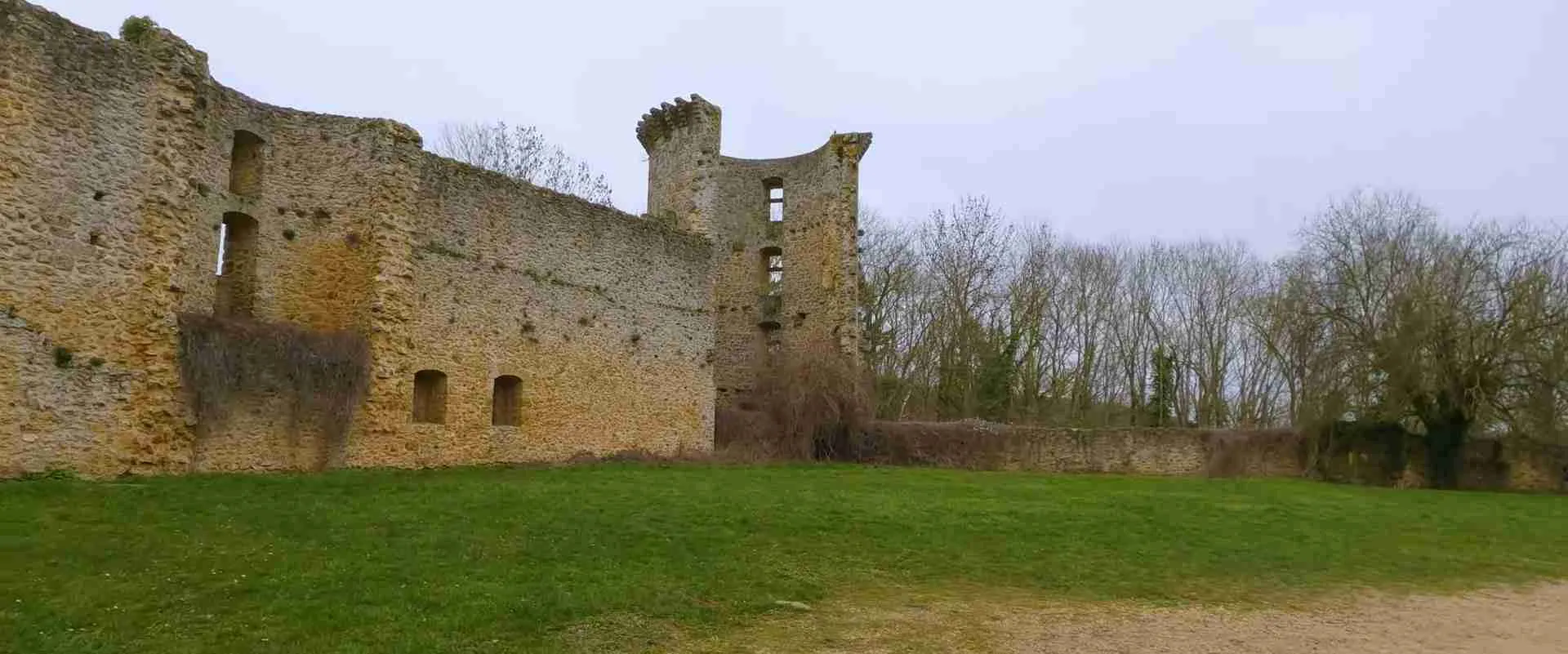
- The Château de la Madeleine at Chevreuse preserves an elongated rectangular keep — a “donjon barlong” — that sources date to the 12th century, along with intact curtain walls, square towers, machicolations, and a guard tower, all set in motion by Guy I of Chevreuse from around 1020 onwards and widely considered one of the best-preserved feudal donjon complexes remaining in Île-de-France.
- The Donjon de Maurepas is a rare 12th-century cylindrical tower standing 20 metres on a low earthen mound; its external buttresses make it, according to current regional surveys, the only surviving buttressed keep in Île-de-France, distinguishing it sharply from the square and polygonal keeps characteristic of the wider Capetian building programme.
- The Château de Breteuil in Choisel preserves the footprint of a medieval fortified manor — including the square courtyard plan and dry moat — within a Louis XIII brick-and-stone residential château constructed after 1596 by Thibault Desportes and thereafter associated with the Breteuil family from 1712.
- These three monuments define a clear developmental arc: from the hilltop seigneurial keep commanding the Yvette valley (Château de la Madeleine) and the valley-floor motte-tower controlling a lowland passage (Donjon de Maurepas) to the domesticated defensive compound that transformed coercive fortification into aristocratic residence (Château de Breteuil).
- The hilltop castrametation practised by Capetian lords in the Yvelines parallels — through convergent independent development, with no historical connection between the two traditions — the mountain fortress strategies of the Goguryeo kingdom in East Asia, where analogous topographic logic drove comparable defensive positioning across the same broad centuries.
- All three monuments are classified as Monuments Historiques and remain accessible to visitors within the Haute Vallée de Chevreuse Regional Nature Park, the park’s own headquarters occupying the medieval courtyard of the Château de la Madeleine.
People Also Ask About Chevreuse Valley Defensive Strongholds
What is the Château de la Madeleine in Chevreuse, and when was it built?
The Château de la Madeleine is a ruined yet substantially intact medieval castle perched on a rocky promontory above the town of Chevreuse in the Yvelines département of Île-de-France. Its construction was initiated between 1020 and 1090 under Guy I, lord of Chevreuse, whose objective was to establish a fortified point commanding the Yvette valley below. The castle began as a wooden keep surrounded by a palisade; the current stone keep — a donjon barlong, or elongated rectangular donjon — is dated by archival sources to the 12th century, with subsequent additions including battlements, a guard tower, round towers, and machicolations extending the complex through the 15th century. The castle is listed on the Supplementary Inventory of Historic Monuments (inscribed 1948) and today serves as the headquarters of the Haute Vallée de Chevreuse Regional Nature Park, with free public access to the courtyard, curtain walls, and cellars.
What makes the Donjon de Maurepas architecturally significant among medieval keeps in Île-de-France?
The Donjon de Maurepas is a 12th-century cylindrical stone tower, approximately 20 metres tall, standing on a low motte in the commune of Maurepas in the Yvelines. Its primary significance among the region’s medieval military monuments is structural: it carries external buttresses — projecting masonry ribs attached to the outer wall face to resist lateral thrust and reinforce the cylindrical shell — making it, according to current regional heritage surveys, the only surviving buttressed keep in the entire Île-de-France. This is especially unusual because buttressed cylindrical towers were not a standard feature of Capetian military architecture, which generally relied on wall mass alone or on circular towers integrated with a curtain wall system. The Donjon de Maurepas was dismantled by English forces in 1432 during the Hundred Years’ War; today only the keep itself survives, leaning against a farm building at its original location in the village, and it has been classified as a Monument Historique since 1926.
How does the Château de Breteuil reflect the transition from feudal fortification to residential château?
The Château de Breteuil illustrates this transition with exceptional clarity because its architectural evolution is documented from the 12th century to the present, and because the shift was never complete: elements of the medieval defensive plan survived within the Louis XIII building. A fortified manor on the site — at a place then called Bévilliers — is attested from at least 1142. When Thibault Desportes acquired the property in 1596 and began constructing the present building, he preserved the medieval spatial arrangement: a square courtyard enclosed by walls, with dry moats running around the perimeter. The new superstructure was built in the Louis XIII brick-and-stone style characteristic of early 17th-century Île-de-France, with warm white limestone from Cernay-la-Ville and rose-pink Chevreuse brick articulated into corner pavilions, a central corps-de-passage, and a rear wing filling the full courtyard width. The effect is a building that reads as a thoroughly civil Renaissance residence but retains its medieval ground logic — the massed plan on dry moat — beneath the new façade.
How do Capetian hilltop keeps compare to Goguryeo mountain fortresses?
Both the Capetian keeps of the Yvelines and the mountain fortresses (sanseong) of the Goguryeo kingdom in East Asia arrived, through convergent independent development, at a shared strategic insight: that elevated terrain provides a passive defensive advantage that no amount of wall thickness on flat ground can fully replicate. In the Yvelines, the Château de la Madeleine was positioned on a promontory to command the Yvette valley and its approach roads; in the Goguryeo tradition, mountain fortress-cities such as Wandu Mountain City (Hwando) were sited on defensible peaks to shelter the court during war while a paired lowland city (Gungnae/Guonei) served as the administrative capital. Both traditions also moved from timber to stone construction over time and integrated the natural rock face into the defensive system wherever possible. The structural differences are equally instructive: Goguryeo fortresses enclosed entire mountain summits and functioned as full refuge cities with palace complexes, warehouses, and water management systems, while Capetian keeps were seigneurial structures operating as nodes in a dispersed feudal network, smaller in scale but comparably strategic in siting. The parallel is architectural and strategic, not genealogical or diffusional — the two traditions had no contact with each other.
Extended multi-day tours – 5+ days
Featured Paris Multi-Day Tour Packages

5 days
5 Days of Art, Gardens & Royal Splendor: Paris, Giverny & Versailles
- ✓ Comprehensive Paris tour
- ✓ Expert local guides included
- ✓ All accommodation arranged
- ✓ Transportation provided

4 days
Independent Paris City Stay
- ✓ Comprehensive Paris tour
- ✓ Expert local guides included
- ✓ All accommodation arranged
- ✓ Transportation provided
6 days
Enchanting 6-Day Journey Through Paris With Disneyland and Palace of Versailles
- ✓ Comprehensive Paris tour
- ✓ Expert local guides included
- ✓ All accommodation arranged
- ✓ Transportation provided

5 days
Paris in Color, Scent & Flavor
- ✓ Booking needs min. 2 travelers
Multi-day tour packages powered by TourRadar. Prices and availability subject to change.
The Chevreuse Valley and Its Feudal Geography
The Chevreuse Valley occupies a distinct sub-region of the Yvelines département, roughly 30 to 45 kilometres southwest of central Paris. The valley is carved by the river Yvette, a tributary of the Orge, which drains a low plateau bounded to the north by the forests south of Versailles and to the south by the ranges of the Essonne. In the Middle Ages, this topography gave the valley strategic importance: the Yvette corridor was a natural route between the royal domain centred on Paris and the forested interior of the Pays d’Yveline, a vast wooded territory that formed the hunting reserve and the territorial borderland of the early Capetian kings. Controlling the valley meant controlling movement between the Loire basin and the Île-de-France, and between the royal roads connecting Paris to the great abbeys of the region — among them Port-Royal-des-Champs, the Vaux de Cernay, and Saint-Denis.
The geology of the plateau reinforces the historical picture. The Haute Vallée de Chevreuse Regional Nature Park’s own geological survey documents a layered sequence: at the plateau summits (around 170 metres), clays overlying formations of meulière — a dense, cavernous silicified millstone rock highly resistant to weathering — cap the high ground; below these, on the valley flanks, Fontainebleau sands and sandstone strata (the grès de Fontainebleau) are exposed in abandoned quarries and natural outcrops; at the valley floor, green Romainville clay underlies the alluvial plain. This sequence determined both where lords built and what they built with. The rocky promontories at valley edges — where meulière and sandstone beds resist erosion and project above the surrounding relief — were ideal castle sites: naturally defensible, geologically stable, and equipped with local building stone on the same ground. The Château de la Madeleine stands on one such promontory above Chevreuse; the Donjon de Maurepas, by contrast, sits on a low earthen mound in the Mauldre valley, on entirely different geological and strategic logic.
The political geography of the valley was equally complex. From at least the 11th century, the seigneury of Chevreuse was held by a succession of lords — the Guy (Gui) lineage, then various successors through sale and inheritance — who held their land nominally from the Capetian crown but in practice exercised considerable local autonomy. The barony of Chevreuse was elevated to a duchy in 1545 and to a duché-pairie in 1612, tracking the consolidation of French aristocratic privilege across the early modern period. To the north of the valley, the village of Maurepas (originally written Malrepast) had a different trajectory: its earliest documented owner was the Abbey of Saint-Denis, the great royal necropolis abbey, which had held the domain since at least the 8th century. Faced with Norman raids from the 9th century onwards, the abbey transferred the domain to the lords of Chevreuse as a protective measure, and the family of Malrepast — the local cadet line — received the castle that would eventually leave behind the Donjon de Maurepas. To the south, the domain of Bévilliers, which would become Breteuil, occupied a separate promontory in what is now Choisel and passed through a long succession of minor seigneurial families before its decisive architectural transformation at the end of the 16th century.
Together, these three sites — Chevreuse, Maurepas, Choisel — formed nodes in the feudal web of the Yvelines. They were not a coordinated defensive system but an accumulated landscape of individual seigneurial assertions, each castle expressing the interests of its lord against neighbours, brigands, and royal encroachment alike. Understanding them requires reading them together: as a sequential record of how feudal defensive thinking translated into masonry in this specific corner of the Capetian heartland, and how that thinking was gradually domesticated as the political conditions that required it changed.
From Motte to Masonry: The Capetian Building Sequence in the Yvelines
The emergence of the stone keep across the Île-de-France in the late 10th and 11th centuries was part of a broad structural change in how feudal lords expressed and secured their power. The motte-and-bailey — an artificial or natural earthen mound (motte) topped by a wooden tower, paired with an enclosed ground-level courtyard (bailey) defended by a wooden palisade — had served as the standard instrument of seigneurial fortification since at least the 9th century. In the absence of permanent stone construction, the motte provided elevation, the timber tower provided a defensible refuge, and the palisade secured the surrounding enclosure. The system was fast to build, required no specialist stoneworkers, and could be adapted to almost any terrain. Its weakness was permanence: wood rots, burns, and cannot be raised to the heights or wall thicknesses that stone allows.
The shift to stone construction in the Yvelines, as elsewhere in the Île-de-France, proceeded in a characteristic sequence. First, the palisade was replaced with a stone curtain wall encircling the bailey, protecting the interior against attack without yet requiring a new keep. Second, a stone donjon replaced the timber tower, typically built on or near the original motte summit. The donjon’s primary functions were multiple: residential and administrative at its upper floors, where the lord’s hall and solar were located; symbolic and demonstrative at its upper battlements, projecting power over the surrounding countryside; and military at its base, where the deep walls and narrow openings resisted battering and undermining. In the Capetian heartland, the earliest stone keeps were rectangular in plan — the “donjon barlong” or elongated rectangular form — following the Anglo-Norman pattern that dominated military architecture from the late 10th century through the mid-12th.
The distinctive tower of Houdan, roughly 30 kilometres northwest of Chevreuse, illustrates the next evolutionary step. Constructed around 1120 to 1137 and attributed to Amaury III of Montfort, the Houdan keep is cylindrical in form — 16 metres in diameter, 25 metres tall — flanked by four external turrets at cardinal points. The walls average 3 metres in thickness. This experiment in circular planning predates the systematic circular keep programme of Philip II (Philip Augustus) by several decades, and it stands in the same Yvelines territory that saw the Donjon de Maurepas built as a buttressed cylinder within the same general century. The Houdan tower was thus not an isolated oddity but evidence of regional architectural experimentation in which Capetian lords and their builders tested new forms alongside the established rectangular model.
Philip II’s regularisation of castle design from the 1190s onwards — producing the canonical “Philippian castle” plan of cylindrical corner towers on a roughly square enclosure — did not displace these earlier forms but added a new register of royal military architecture to the existing feudal landscape. The seigneurial keeps of the Yvelines, built before the royal standardisation, represent the experimentation and adaptation that preceded it. The Château de la Madeleine’s rectangular keep, the Donjon de Maurepas’s buttressed cylinder, and the later transformation at Breteuil are best understood not as a single story but as separate local responses to shared structural pressures: the need to hold territory, to resist armed challenge, and to signal authority through permanent masonry in an era when stone was the clearest available language of power.
The transition from wooden to stone construction also involved a change in the labour and supply relationships that underlay castle-building. Quarrying, cutting, and laying stone required specialist masons whose skills were portable and whose services were purchased or commanded across considerable distances. The geology of the Chevreuse plateau — meulière at the hilltops, sandstone on the upper slopes, limestone in specific valley-floor deposits — shaped what was available locally and therefore what could be built without long-range transport. Meulière is particularly workable despite its cavernous texture, providing good thermal mass and resistance to projectile impact; it was used extensively in prestigious structures throughout the Chevreuse region, including the Château de la Madeleine and the nearby Vaux de Cernay abbey. Fontainebleau sandstone, available from the plateau edges, supplemented meulière construction in the region’s curtain walls and terrace works. Later, the introduction of the “pierre de Cernay” — the warm white limestone quarried at Cernay-la-Ville in the same valley — brought a more refined dressable stone to the aristocratic building programme, used prominently at the Château de Breteuil centuries later.
Château de la Madeleine: Strategic Topography and 11th-Century Masonry
The Château de la Madeleine occupies a naturally defensible spur projecting above the Yvette valley on the eastern edge of the town of Chevreuse. From this position, the castle commands the valley floor and the principal approach routes converging on the town, providing both visual oversight — the castle’s battlements survey the Yvette corridor for several kilometres — and a tactical height advantage over any force approaching from the plain below. The castle’s name derives from the chapel of Saint Mary Magdalene (Sainte Marie-Madeleine) that once stood within its enclosure; the dedication survives in documents and local memory even though the chapel structure no longer stands.
Construction was initiated between 1020 and 1090 by Guy I (Gui I), lord of Chevreuse, whose primary objective was protective: Chevreuse had suffered pillaging, and a fortified strongpoint commanding the town from above was the standard Capetian-era response to raiding and seigneurial competition. The earliest phase was a wooden keep surrounded by a timber palisade — a standard motte-and-palisade configuration matched to what the first phase of construction could deliver in speed and available material. Archival sources indicate that the stone keep visible today was built in the 12th century, replacing the timber structure on the same elevated site; a subsequent expansion in the 13th century, associated by sources with a later lord of Chevreuse known from the name Anseau, added battlements and strengthened the enclosure perimeter, though the exact dating and attribution of these phases remains partially uncertain in the surviving documentation.
The castle continued to evolve through the 15th century, when significant additions including a well and revised window openings in the keep were incorporated, and official sources record the construction as complete by 1483. The castle passed through dramatic political upheaval during the Hundred Years’ War: in 1356, the then lord of Chevreuse, Ingerger the Great, was captured by the English and forced to sell the estate to pay his ransom — the new proprietor, Pierre de Chevreuse, a financial counsellor to the Valois kings, continued to develop the property and the town below. The castle was subsequently occupied by the English during their control of the Paris basin, and only returned to French sovereignty under Charles VII in 1438. In the 17th century the castle underwent further modification, connected to the wider renovation of the duchy under successive owners including the dukes of Luynes and documented in part by the presence of Jean Racine, who had strong ties to the nearby Jansenist abbey of Port-Royal-des-Champs and is associated with the Chevreuse area in local accounts, though his precise role in supervising any specific architectural work at the castle should be treated as uncertain on the current evidence.
The intact portions visible today are extensive and architecturally legible. The complete curtain wall survives with two square towers in the east, facing the village and the main approach. The main gate, flanked by two towers, gives access to the interior courtyard; the stone pediment of the gate collapsed at some point and was replaced with a wooden lintel, creating an instructive juxtaposition of medieval masonry and later repair. Two round towers complete the perimeter: one is semicircular, the other is surmounted by a small turret for watch and observation. Along the top of the curtain walls, machicolations project outward — stone brackets with openings between them through which defenders could drop projectiles or boiling materials onto attackers at the base of the wall without exposing themselves. The 15th-century well in the inner courtyard attests to the provision of water security within the enclosure. Today the courtyard, the guard tower, and the cellars (housing a permanent exhibition on “Vie de château” — the archaeology and social history of castle life in the region) are all open without charge.
Keep Wall Thickness and Structural Load of Stone Turrets
The structural ambitions of the Château de la Madeleine’s stone keep are most legible in its surviving masonry. The donjon barlong — the elongated rectangular keep form that characterised Île-de-France seigneurial construction in the 11th and 12th centuries — achieves its defensive integrity through the interplay of wall mass and plan geometry. Rectangular keeps of this period in the Capetian heartland typically employed curtain walls whose base thickness ranged from approximately 2 to 3 metres, following the standard practice documented in French Romanesque military construction across the 11th and 12th centuries. This thickness was not primarily structural in the modern engineering sense; it served to resist battering-ram attack at the base, prevent undermining by defeating the depth at which an enemy could dig beneath the footing, and provide the mass necessary to support crenellated upper battlements without the sophisticated vaulting systems that later Gothic military architecture would develop. The walls were constructed of local meulière stone — the dense, cavernous, highly erosion-resistant silicified rock characteristic of the Chevreuse plateau — set in lime mortar, with the cavernous texture of the meulière providing a naturally irregular interlocking surface that enhanced wall cohesion.
The structural load of the stone turrets and towers present a different engineering problem from the curtain walls. A tower that projects outward from the curtain line — as the square towers and round towers of the Madeleine enclosure do — must resist not only lateral loading from siege weapons directed against it but also the compressive and bending loads generated by its own mass at the point where it meets the curtain wall and at its own base. Medieval builders managed these loads primarily through the depth of foundation and the mass of the plinth, relying on the same empirical rule-of-thumb knowledge that governed all pre-modern masonry construction: if the base is wide enough relative to the height, gravity and compressive strength will keep the structure standing without theoretical calculation. The square towers at the Madeleine, facing the village approach where attack was most likely, are particularly substantial at their base — a visual expression of the greater threat expected from that direction and the greater loads generated by the tower mass. The round towers, by contrast, are more slender and serve primarily as observation and flanking positions rather than as primary assault-resistant bastions.
The rooflines of the turrets and towers, now largely absent or modified, were originally timber-framed conical caps or flat wooden platforms providing fighting positions at the summit. The stone machicolations along the curtain wall parapets extend the defensive capacity outward and downward: their corbelled projections carry the load of the projecting stone floor through a series of diagonal bracket elements back into the wall face, a form of cantilever that was well within the capacity of the local meulière coursework. The 12th-century openings on one face of the keep — narrow slits characteristic of the early medieval period — contrast with the 15th-century windows opened on the opposite face, which are larger and admit more light, reflecting the improved security conditions of the post-Hundred-Years’-War period when the keep’s internal function shifted toward residence and administration rather than purely military refusal. This visible stratigraphy across the keep’s two elevations encodes the castle’s chronological development in a single masonry sequence.
Timber Drawbridge Gateways and Dry Moat Cut-outs in Sandstone Bedrock
The entry sequence of the Château de la Madeleine was governed by a system of controlled access that combined timber bridging with rock-cut or earthwork moat elements. Historical accounts of the castle confirm that the main gate was equipped with drawbridges serving both pedestrian and vehicular passage, with a moat whose water was retained by a dam and which likely served domestic as well as defensive functions — a useful dual-purpose arrangement common to many Capetian-era castles where a permanent water supply was a strategic priority. The dam arrangement implies a partially water-fed moat at some phase of the castle’s history, though the moat as currently preserved around the rocky promontory reads as predominantly dry — the natural gradient and the permeability of the local substrata making a permanent water table difficult to maintain without continuous artificial management.
The geology of the Chevreuse promontory is directly relevant to this engineering. The Haute Vallée de Chevreuse’s documented geological sequence places Fontainebleau sandstone strata on the upper valley slopes, between the meulière-capped summits and the alluvial clay of the valley floor. These sandstone beds — whose Oligocene formation is well characterised across the wider Île-de-France basin — are exposed in the rocky outcrops and former quarry faces of the plateau edges throughout the Yvelines. Where a moat was cut or deepened around the castle promontory, the builders would have encountered this layered substrate: meulière and sandstone in the upper exposures, transitioning to softer sand and clay at lower levels. Rock-cutting in sandstone formations, while demanding in labour, produced dimensionally precise and stable moat profiles; the relative softness of Fontainebleau sandstone compared to crystalline rock made it more tractable for iron tools than, say, granite, while its cohesion when dry provided stable moat walls that did not require continuous lining or revetment.
The timber drawbridge mechanism completed the entry system. A timber drawbridge spanning the moat served the main gate, operated — in the standard arrangement of the period — by counterweights or windlass mechanisms housed in the gatehouse tower above. The bridge could be raised to close the gap completely, denying entry not only to men on foot but to cart traffic carrying provisions or siege materials. The gate portal itself, flanked by two towers, would originally have been further protected by a portcullis — a vertically sliding grille of timber or iron — operating in wall-channels cut into the gate passage. The loss of the stone pediment above the gate and its replacement with a wooden lintel reflects later repair work rather than the original arrangement; the flanking towers and their gate-chamber spaces would have housed the mechanisms and personnel responsible for operating the drawbridge and portcullis simultaneously. This layered entry system — moat, drawbridge, gate towers, portcullis — replicated in miniature the defended-approach logic of the great royal fortress programmes, adapted to the scale and resources of a seigneurial builder working with local stone and local carpentry.
The Donjon de Maurepas: The Buttressed Keep on the Mauldre Motte
The Donjon de Maurepas stands as the least visible and most architecturally unusual of the Yvelines’ major medieval keeps. Located at the Rue de l’Église in the commune of Maurepas — a town that grew rapidly in the 1970s as a planned new settlement but that preserves its medieval core around the old church and the keep — the tower rises roughly 20 metres from a low earthen mound, the motte that formed the platform of the original castle complex. A farm building leans against the surviving masonry, creating the hybrid rural-ruin landscape that characterises many of the smaller Heritage-classified structures of the Yvelines hinterland.
The domain of Maurepas — recorded in early documents as Malrepast, a name suggesting poor or difficult terrain — belonged to the Abbey of Saint-Denis from at least the 8th century. Saint-Denis’s control of the property placed it within the sphere of one of the most powerful ecclesiastical landowners in the Capetian kingdom; the abbey’s extensive rural holdings across the Île-de-France were both an expression of its royal patronage and a source of the agricultural surplus that funded its architectural ambitions. When Norman raids began threatening the Paris basin from the 9th century onwards, the abbey found its rural holdings difficult to defend without permanent fortification on the ground. The transfer of the Maurepas domain to the lords of Chevreuse was a pragmatic response: military protection in exchange for tenure, a transaction characteristic of the feudal land-for-service logic that underlay most Capetian territorial arrangements. The family of Malrepast, installed as castellans of the new strongpoint, built the wooden precursor and then — in the 12th century — the stone tower that still stands.
The cylindrical form of the Donjon de Maurepas marks it as a product of the 12th-century transition away from the rectangular keep towards more structurally efficient circular plan geometries. A cylindrical shell carries lateral loads more evenly around its circumference than a rectangular form, which concentrates stress at its corners — a structural truth that medieval builders knew empirically even without formalised mechanical theory. The corners of a rectangular keep were precisely the points most vulnerable to mining (an enemy could dig beneath a corner foundation, collapse the corner, and bring down a section of wall) and to projectile impact. A cylindrical shell, by presenting no salient angles, deflects rather than absorbs the force of projectiles and denies the enemy a corner to attack. Yet what distinguishes the Donjon de Maurepas from the other cylindrical towers of the Yvelines is its buttresses.
External buttresses on a cylindrical tower are structurally unusual and functionally telling. Buttresses are projecting masonry ribs attached to the outer face of a wall, designed to resist the lateral thrust or bending tendency of the wall above or the internal structures behind it. In Gothic church architecture, flying buttresses manage the outward thrust of high stone vaults; in Romanesque church design, engaged buttresses stiffen tall nave walls against wind and uneven settlement loading. On a cylindrical keep, buttresses serve a different purpose: they stiffen the shell against the shearing and bending forces generated by siege impact — particularly the concentrated impact of projectiles and battering weapons directed at the wall face — and they provide additional mass at the base of the tower to resist undermining. The Donjon de Maurepas is documented as the only surviving buttressed keep in Île-de-France, which implies either that its builder had access to structural knowledge or precedent not widely applied in the region, or that the specific site and threat conditions at Maurepas prompted an unusual engineering response. No documentary evidence of the original builder’s identity or the reasoning behind the buttress choice survives; what is clear is that the decision produced a tower of exceptional structural robustness, even in its partial and ruined state.
The castle’s history was violent and abbreviated. During the Hundred Years’ War, the lords of Malrepast abandoned the strongpoint, and the tower was occupied by a brigand band under a certain Haymon de Massy, who used it as a base for raiding the surrounding countryside. In 1425, English forces captured the castle and executed the occupants. In 1432, English troops dismantled the castle — a systematic military demolition intended to deny the structure to any subsequent French use — leaving only the stubborn cylindrical keep, too massive to take down quickly without specialist siege equipment. After the war’s conclusion, the domain returned to the Chevreuse sphere, but the castle was never rebuilt; the keep alone stood in the village, incorporated into the agricultural landscape, its function having passed from military sentinel to building material and boundary marker. The Mérimée database of the French Ministry of Culture confirmed the site’s classified heritage status from 1926, the earliest of the three Yvelines monuments discussed here to receive formal protection, reflecting the rare architectural interest of its buttressed form even to early 20th-century heritage assessors.
What the Donjon de Maurepas offers today is not spectacle — it lacks the machicolations, curtain walls, and intact entry sequences of the Madeleine — but specificity. The tower encodes, in its buttressed cylinder and its height, a precise moment in the feudal building sequence: the point at which a 12th-century seigneurial builder chose a non-standard structural solution to a problem of defensive engineering that the standard rectangular or unbuttressed cylindrical keep could not solve to his satisfaction. That the building survived in exactly this state — stripped of its accompanying castle complex but with the keep’s most structurally unusual feature still legible — is a form of negative preservation by demolition, the English force that destroyed the surrounding walls inadvertently leaving the most architecturally significant element standing alone.
Château de Breteuil: Civil Architecture from Fortified Outpost to Residential Chateau
The Château de Breteuil stands on a low promontory overlooking the Chevreuse valley from the commune of Choisel, 35 kilometres southwest of Paris. Its current appearance — a harmonious Louis XIII building of rose-pink brick and warm white limestone arranged in a courtyard plan with corner pavilions and a rear corps-de-logis — gives little indication of its defensive origins, but the spatial logic of the medieval fortification it succeeded persists in the building’s plan: the square courtyard, the surrounding dry moat, and the retained medieval dovecote all testify to the fortified manor that occupied the site before the 17th-century reconstruction began. The place name “Bévilliers,” used for the site in documents before the Breteuil family association took hold in the 19th century, possibly derives from a Gallo-Roman agricultural origin (from two villas, as the Breteuil family’s own historical account suggests), and the seigneury itself is documented in records from as early as 1142, indicating a medieval presence of some kind at the site well before the current building was conceived.
The decisive architectural moment came in 1596, when Thibault Desportes, Grand Audiencier de France — a royal administrative official of considerable financial standing — acquired the property from Nicolas Le Jay and began constructing an entirely new château on the site of the old fortified manor. Desportes chose the architectural vocabulary of his moment: the brique-et-pierre (brick and stone) style that had been the dominant idiom for prestigious residential construction in the Île-de-France since the late 16th century and that would come to be associated almost exclusively with the reign of Louis XIII. The characteristic two-tone facade — warm white limestone (here the “pierre de Cernay,” quarried at Cernay-la-Ville a few kilometres away in the same valley) combined with rose-pink brick made locally from Chevreuse clays — was simultaneously a structural and an aesthetic choice. Brick provided the infill panels between stone frames, its coursed regularity and moderate compressive strength complementing the carved precision of the limestone surrounds. Stone provided the quoins, window architraves, door surrounds, and string courses — the dimensionally precise, loadbearing elements that required dressed ashlar rather than moulded units.
The plan of the new château retained the medieval defensive arrangement in its bones. The square courtyard, enclosed on all sides by walls and construction, preserved the plan-massé (massed plan) logic of the fortified manor: a compact, inward-looking layout that concentrated all the building’s mass around a sheltered interior space. The dry moat — maintained without water for reasons of hygiene and drainage management, a common practice in late medieval and early modern manorial construction — continued to define the boundary between the château platform and the surrounding terrain. The medieval dovecote survived as the most visible physical remnant of the older structure, its circular form rising from the garden landscape adjacent to the new building. These survivals were not accidental: Desportes was building on a prepared and already partially defended site, and the moat-and-courtyard layout gave him the spatial framework for a château that was simultaneously new in its materials and vocabulary and continuous in its defensive topography.
Pavilion Geometry and Brick-and-Stone Facade Stabilization
The facade of the Château de Breteuil is organised around a pavilion geometry that was one of the defining innovations of French architecture in the late 16th and early 17th centuries. The entrance front presents two corner pavilions — square plan projections rising higher than the intervening wings, their elevation capped with a hipped roof that gives them a distinct vertical emphasis — flanking a central corps-de-passage, a transitional building volume containing the entry gate and giving access to the courtyard. At the back of the courtyard, a large corps-de-logis (main residential wing) fills the full courtyard width. This four-element composition — two angle pavilions, a corps-de-passage, a corps-de-logis — is the standard pavilion formula of the Henri IV and Louis XIII periods, a composition that can be found across the Île-de-France in buildings ranging in scale from the great châteaux to substantial bourgeois residences, and whose regularity and modularity made it well suited to the brick-and-stone material system. The Château de Breteuil’s design has been noted for its resemblance to the Château de Dampierre in the same valley, a later 17th-century building by Jules Hardouin-Mansart that carries the pavilion logic further into the classical language of the grand siècle.
The structural role of the brick-and-stone combination in facade stabilisation merits specific attention. In a pure ashlar limestone façade, the wall derives its structural integrity entirely from the mass and bond of the stone courses, with the carved stone elements — quoins, pilasters, cornices — doubling as decorative and structural members. In a brique-et-pierre facade, the two materials operate in complementary roles: the stone elements — particularly the corner quoins and the window and door surrounds — act as stiff structural frames that resist distortion under wind loading and differential settlement; the brick infill panels within these frames contribute compressive strength over the large flat areas of wall between openings, where a pure stone facing would be both expensive and visually monotonous. The Breteuil building’s structural system is specifically described in heritage documents as “bâtiments à structure en brique et remplissage sous enduit” — buildings with brick structure and rendered (plastered) infill. This implies that the brick formed the primary structural fabric of the walls, with the limestone elements attached as facing and framing rather than as the primary load-bearing mass. The rendered (plastered) surface of much of the brick area — a common treatment in Louis XIII construction — protected the softer brick units from weathering while allowing the pale limestone elements to read clearly against the darker background of the plaster.
The pavilion geometry also performs a structural function in a less obvious way: by projecting the corner pavilions forward from the main facade line, the building creates buttress-like stabilising masses at the most structurally vulnerable positions — the corners — where a purely flat facade would be most susceptible to lateral movement and to the concentration of stress from the roof structure above. The pavilion projection gives the corner a greater plan depth, increasing its rotational inertia and its capacity to resist the horizontal racking forces that act on tall masonry walls. This is not the same as the explicit buttressing of the Donjon de Maurepas — it is a softer, more architecturally integrated expression of the same underlying structural logic — but it illustrates how the formal vocabulary of French residential architecture in this period was never purely aesthetic: the pavilion grammar encoded structural knowledge in the same gesture that it expressed social status and architectural ambition.
The Breteuil family’s subsequent ownership, beginning with Charles Le Tonnelier de Breteuil in 1712, brought further modifications to the building and gardens without fundamentally altering the structural or spatial character of the Desportes construction. The 19th-century restoration of the Henri IV brick-and-stone vocabulary — undoing a plastering-over of the facades that had been fashionable in the Napoleonic period — returned the building to its characteristic two-tone appearance. The château remains in Breteuil family ownership, operates as a public cultural site with guided tours featuring wax figures of historical personalities produced by the Grévin Museum, and contains a significant collection including the Table of Teschen (1779), a jewelled diplomatic gift produced by the Saxon court goldsmith Neuber and now displayed in the château’s state rooms.
Curtain Walls, Terrace Engineering, and the Stone Landscape of the Yvelines
The curtain walls that survive at the Château de la Madeleine represent the highest-density concentration of intact medieval military masonry in the Yvelines, but they do not stand alone in the regional landscape. The broader feudal building programme across the Chevreuse plateau left a dispersed legacy of walled enclosures, terrace earthworks, and masonry fragments that, taken together, describe a landscape remade for defensive occupation across the 11th through 15th centuries.
The curtain wall as a military element emerged across the Île-de-France in the context of the transition from timber palisade to stone enclosure already described. In its mature form, the medieval stone curtain wall connected the towers and keeps of a castle complex into a continuous defensive barrier, its height, thickness, and surface features calibrated to the specific threats anticipated. The general Romanesque standard — curtain walls with a base thickness roughly in the range of 2 to 3 metres, built from local stone set in lime mortar — was sufficient to defeat laddering, to resist battering at the base, and to provide the elevated firing platform that gave defenders their decisive tactical advantage: the ability to shoot outward and downward while remaining largely protected from return fire. Battlements (merlons and crenels alternating along the parapet) gave individual defenders covered positions behind the raised merlons; machicolations, as seen at the Madeleine, extended this advantage outward beyond the wall face for close-in defence of the wall base.
At the Château de la Madeleine, the curtain wall’s relationship to the underlying topography is the key to its engineering. The promontory site provided natural cliff faces on its most exposed sides, meaning that the curtain wall did not need to rise from flat ground everywhere: in the most precipitous sections, the rocky escarpment itself served as a de facto defensive barrier, with the curtain wall rising from the cliff edge to add height where the natural terrain alone was insufficient. This integration of built wall with natural rock face is an economy of means characteristic of experienced medieval military building: the stonemason’s wall addressed the gaps; nature addressed the rest. The terrace formations visible around the promontory, where the approach paths to the castle grade across the slope, are partly natural and partly modified by medieval earthwork — broad platforms cut into the hillside to facilitate movement of men and materials during construction, and later serving as defended approach zones that could be raked by fire from the curtain walls above.
The dry-stone construction tradition referred to in the Yvelines’ rural building heritage — field walls, boundary enclosures, and agricultural terracing throughout the valley — shares technical ancestry with the mortared curtain walls of the castles. Dry-stone walling (construction without mortar, relying on the geometric interlock of shaped stones for structural integrity) is the most labour-intensive and the most materially demanding form of masonry, as every stone must be individually fitted rather than bedded in forgiving mortar. In the Yvelines, local meulière was extensively used for dry-stone agricultural walls well into the modern period, its cavernous surface providing exceptional frictional grip between courses. The castle curtain walls were mortared rather than dry-stone at their primary structural faces — lime mortar was essential for the heights and loads involved in a defensive wall — but dry-stone techniques may have been employed in secondary earthwork revetments, in rubble fill cores, and in the terracing and approach-path engineering that surrounded the main masonry structures.
The terrace engineering at Breteuil follows a different logic from the hilltop terracing at the Madeleine. The Breteuil promontory is lower and more gradual than Chevreuse’s rocky spur; the terracing here was primarily drainage and garden engineering rather than defensive earthwork. The retention of the dry moat from the medieval plan into the 17th-century reconstruction required careful management of the local water table and surface runoff — the French term “douves gardées sèches pour des raisons de salubrité” (moats maintained dry for sanitary reasons) reflects a practical hygiene concern as much as a defensive one, since a stagnant water moat in a residential compound was a source of disease rather than a reliable military advantage in a post-gunpowder context. The terrace gardens added by the Breteuil family in the 17th and 18th centuries extended this engineered landscape into the pleasure grounds of the château park, with graded slopes, retaining walls, ponds, and the orangerie structure all requiring the same basic competence in earthwork management that the original military terracing had demanded.
Hilltop Castrametation Across Traditions: Capetian Keeps and Goguryeo Sanseong
One of the most instructive ways to read the Chevreuse Valley strongholds is in the context of a global architectural question: what does a society do when it needs to control territory from a fixed point, and how does it translate the strategic logic of elevated terrain into permanent building? The answer, arrived at independently in widely separated historical traditions, tends to converge on a shared set of structural and topographic principles. The comparison between the Capetian hilltop keeps of the Yvelines and the sanseong (mountain fortresses, 산성) of the Goguryeo kingdom in ancient Korea — framed not as genealogical influence or cultural diffusion, since no historical contact existed between the two traditions, but as convergent independent development in response to shared strategic imperatives — illuminates both more clearly than either can be read alone.
The Goguryeo kingdom, which ruled over parts of what is now northeastern China and the northern Korean Peninsula from approximately 37 BCE to 668 CE, developed mountain fortress architecture as a primary instrument of both capital defence and territorial control. The kingdom’s most significant mountain fortresses — Wunü Mountain City (the first capital site), Gungnae (the second), and most documentably Wandu Mountain City (Hwando) near modern Ji’an in Jilin Province, China — were inscribed collectively as part of the UNESCO World Heritage Site “Capital Cities and Tombs of the Ancient Koguryo Kingdom” in 2004. Wandu Mountain City exemplifies the Goguryeo approach: defensive walls were built with a combination of rammed earth and stone facing, integrated wherever possible with the natural cliff faces of the mountain summit, so that the human-made element addressed only the topographic gaps that nature left. The wall at Guonei City’s remains extends approximately 2,713 metres in circumference, with walls 3 to 4 metres high where they survive and 7 to 10 metres wide at the base — dimensions that dwarf the Yvelines curtain walls in both scale and material investment, reflecting the difference between a royal fortress-city and a seigneurial keep. Wandu contained a palace complex, a military camp, a watchtower, residential buildings, warehouses, and 37 identified tombs within its enclosure: a full urban programme within a mountain fortification.
The structural parallel with the Yvelines is most precise in the shared topographic logic. Both the Château de la Madeleine and Wandu Mountain City were positioned on high ground commanding a valley below — the Yvette valley in one case, the Ji’an basin and the Yalu River in the other. Both chose sites where natural cliff faces or steep escarpments reduced the length of curtain wall required, integrating geology into the defensive system. Both evolved from earlier, less permanent construction (timber palisade in the Yvelines; rammed earth with timber in Goguryeo) toward more durable stone building over time. And both responded to the same fundamental military-geographic insight: that height is a force multiplier. A defender on elevated terrain can observe approaching forces at a distance, direct fire downward at an angular advantage, and compel an attacker to charge uphill against defenders who can hold a line with fewer men than a flat-ground engagement requires.
The Goguryeo system also developed a dual-city model that has no direct Capetian analogue but that clarifies the limits of the comparison. The paired design of Gungnae (a plains city for ordinary administration and daily royal life) and Wandu (a mountain fortress for refuge and defence during war) represented a more sophisticated strategic programme than the individual seigneurial keep: the mountain fortress was not meant for permanent occupation but for wartime withdrawal, while the plains city provided the economic and administrative infrastructure of normal governance. UNESCO’s inscription criterion for the site notes that “the system of capital cities represented by Guonei City and Wandu Mountain City also influenced the construction of later capitals built by the Koguryo regime,” indicating that this dual model was institutionalised rather than incidental. The Capetian lords of the Yvelines, by contrast, occupied their hilltop keeps as full-time residential and administrative centres — the distinction between a defensive refuge and an everyday lordship did not operate at the seigneurial scale in the same way it did for a royal court commanding a kingdom.
The construction techniques also diverged in instructive ways. Goguryeo builders worked primarily in the volcanic and metamorphic rock of the Manchurian-Korean mountain belt, whose fractured but geometrically regular jointing allowed for stone-on-stone construction with limited mortar on the larger courses; the natural cliff faces integrated into Wandu’s defensive circuit were basalt and granite formations of far greater hardness and natural height than the meulière and sandstone of the Yvelines. Capetian builders, working in the softer Tertiary geology of the Île-de-France basin, relied more heavily on lime mortar to compensate for the lower tensile strength of their local stone, and their curtain walls generally use a rubble core faced with dressed stone rather than the more monolithic stone construction visible in surviving Goguryeo wall sections. The Yvelines masons also used wood far more extensively in their tower roofs, gatehouse mechanisms, and interior floors — a reflection of the timber-rich environment of the Yvelines plateau — whereas Goguryeo stone construction was often more continuously mineral, with vaulted stone ceilings appearing in the most prestigious tomb architecture within the same building culture.
What the comparison ultimately demonstrates is not that these two traditions were related or that they solved the same problem in the same way, but that the strategic problem of controlling territory from elevated terrain generates a convergent architectural grammar across cultures that have no contact with each other: choose the promontory, exploit the natural cliff face, build the wall where nature falls short, develop the gatehouse and drawbridge to manage controlled access, and position the watchtower to extend the range of observation. This grammar is as legible at the Château de la Madeleine as it is at Wandu Mountain City, and the comparison sharpens our understanding of both by showing what is universal in the problem and what is specific to each tradition’s materials, politics, and available knowledge.
The Feudal Landscape of the Haute Vallée de Chevreuse Regional Nature Park
The three strongholds discussed in this article do not exhaust the medieval military heritage of the Chevreuse Valley. They are the most architecturally significant, the best preserved, and the most thoroughly documented, but the wider landscape of the Haute Vallée de Chevreuse Regional Nature Park contains a more diffuse legacy of feudal building: earthwork remnants of mottes that never acquired stone towers, village church bell-towers that doubled as watching and refuge positions, boundary stone walls whose coursework mixes domestic construction with the residue of demolished castle fabric, and road alignments whose routes still trace the defensive topography of a medieval seigneurial network.
The Haute Vallée de Chevreuse Regional Nature Park was established in 1985 to protect a 256-square-kilometre zone spanning parts of the Yvelines and Essonne départements across 51 communes. The park’s designation recognised the unusual density of historical sites within the area alongside its ecological value — the combination of forested plateau, managed wetlands, and the pastoral valley landscape that has been maintained against the suburbanisation pressure radiating from Paris and Versailles. The park’s headquarters, significantly, occupies the Château de la Madeleine itself, inserting a contemporary conservation institution into the medieval courtyard. This spatial choice is itself an act of interpretation: by making the medieval castle the administrative and educational centre of the modern nature park, the institutional arrangement signals that the historical built heritage and the natural landscape are to be managed as a single integrated system, not as separate categories of conservation object.
Within the park’s boundaries, the Chevreuse Valley was historically among the better-connected corridors in the royal domain south of Paris. The road from Port-Royal-des-Champs (the important Jansenist abbey south of Versailles, established in the late 12th century) through Chevreuse and onward to the Loire basin was a significant secondary route, connecting the royal hunting forest and its associated abbeys to the wider south. The castle at Chevreuse commanded a key node on this corridor, and the moat-and-drawbridge entry system through which travellers had to pass before reaching the town was a fiscal and security checkpoint as much as a purely military structure. Jean Racine’s documented association with the Port-Royal community — he had been educated there as a child and maintained connections throughout his adult life — brings him physically into this landscape, walking the same road between abbey and town that the castle had surveyed for six centuries.
The relationship between the Chevreuse feudal landscape and the wider Capetian royal domain is visible in the political trajectories of its three most important strongholds. The Château de la Madeleine’s barony was elevated to duchy in 1545 and duché-pairie in 1612, tracking the consolidation of the later medieval peerage and the crown’s progressive assimilation of formerly independent seigneurial units into the royal administrative structure. Maurepas’s castle was destroyed in a war whose final outcome was the definitive re-establishment of Valois sovereignty over the Paris basin, after which the domain returned to the Chevreuse sphere without need of a military installation. Breteuil’s transformation from fortified manor to residential château happened in 1596, within the decade of Henry IV’s re-establishment of royal authority after the Wars of Religion — a moment when the defensive rationale for the square courtyard and the moat was already historical rather than operational, retained as spatial grammar and social convention rather than military necessity. The three trajectories together describe the long-term arc of feudal fortification in the Capetian heartland: from instrument of territorial competition to relic of aristocratic memory, preserved not because the walls were still militarily useful but because they encoded the social identity and historical legitimacy of the families that had built and inhabited them.
Heritage Classification, Restoration, and Institutional Care
All three monuments discussed in this article carry formal French heritage protection under the Monument Historique system, though their classification dates, levels of protection, and institutional contexts differ significantly. The Donjon de Maurepas received the earliest and most comprehensive classification: it was inscribed as a Monument Historique on 19 July 1926, at a time when French heritage law was still developing the distinction between full classification (classement) and supplementary inscription (inscription à l’inventaire supplémentaire). The early date reflects the tower’s immediately legible architectural rarity — its buttressed cylindrical form made it identifiable to the heritage assessors of the interwar period as an unusual survival that could not be replaced if lost. The Château de la Madeleine followed in 1948, when it was inscribed on the Supplementary Inventory of Historic Monuments — a lesser protection than full classification but one that created a legal framework for monitoring and intervention. The Château de Breteuil received its designation in 1973, with various parts of the domain separately protected.
The restoration history of the Château de la Madeleine reflects the challenges of maintaining a ruined structure over a long period of institutional transition. The keep was partially restored in the 19th century — a period of broad interest in medieval military architecture across France, stimulated by Viollet-le-Duc’s theoretical and practical work on medieval buildings and by the Romantic cultural appetite for Gothic and medieval aesthetics. The 20th-century modifications associated with the installation of the nature park headquarters in the castle courtyard introduced new construction within the medieval enclosure — a blend of modern architectural language with the surviving stone fabric that is documented and that allows the medieval elements to remain readable while serving a contemporary function. The Département des Yvelines, which has owned the castle since 1981, funds ongoing maintenance and the public access programme.
The Donjon de Maurepas presents a more austere conservation scenario. With no institutional user to fund ongoing maintenance, and with the tower’s partial incorporation into the adjacent farm building creating a complex ownership and responsibility picture, the site’s long-term condition depends on the classified monument protection and on periodic inspection by the French Ministry of Culture’s heritage services. The tower is freely accessible to external view from the public road, but its interior is not open for regular visits; the combination of structural instability and absence of a managing institution makes the site one of the Yvelines’ more fragile heritage assets, preserved by legal status rather than by active institutional investment.
Château de Breteuil, as a privately owned and commercially operated property, has a different conservation dynamic from the public monuments. The Breteuil family’s continued ownership creates a strong incentive for active maintenance — the château’s visitor programme and event income depend on the building’s condition — and successive owners have funded restoration campaigns focused on the facades, the state rooms, and the park landscape. The wax figures programme, the château’s most distinctive visitor attraction, requires regular conservation attention in its own right, as the Grévin Museum’s figures are susceptible to deterioration in the variable humidity conditions of a historic building. The Table of Teschen, as a significant decorative arts object, is maintained with specialist conservation care. The overall conservation picture at Breteuil is one of sustained private investment enabled by consistent visitor revenues.
Visiting the Defensive Strongholds of the Chevreuse Valley
The Château de la Madeleine offers the most comprehensive and accessible visit among the three Yvelines strongholds, with free entry to the courtyard, the curtain wall walkways, the guard tower, and the cellars housing the permanent castle-life exhibition. The castle is open Wednesday through Saturday afternoons (approximately 14:00 to 17:30) and on Sundays and public holidays, with extended morning hours from March through October and afternoon-only hours from November through February. Visitors should verify current opening hours with the Département des Yvelines or the nature park, as seasonal adjustments apply. The castle sits above the town of Chevreuse, which is itself accessible by RER C train from central Paris (Versailles-Chantiers line, Saint-Rémy-lès-Chevreuse terminus), making it one of the most accessible medieval castle sites within the greater Paris region without a car. The walk from the station to the castle requires a short steep climb through the town; the panoramic view over the Yvette valley from the castle battlements rewards the ascent.
The Donjon de Maurepas is accessible as an exterior site at all times, located at the Rue de l’Église in the commune of Maurepas. The tower can be viewed from the public road and surrounding paths; no formal entry or guided visit is offered. Maurepas is served by bus connections from Saint-Quentin-en-Yvelines and from Versailles. Those wishing to combine the Donjon de Maurepas with other heritage sites in the Yvelines typically pair it with a walk through the town’s historic core, which preserves the church of Saint-Sauveur and the surrounding medieval village fabric, or incorporate it into a cycling route through the regional nature park. The AllTrails-documented circular route from Maurepas combines the keep with the Courance basin pond in the forest, a pleasant low-gradient walk suitable for families.
The Château de Breteuil at Choisel is open daily (check the château’s own website for current seasonal hours and admission prices, which are subject to periodic revision). The visit includes the château’s state rooms with their wax figure tableaux depicting French historical personalities from Louis XVI and Marie-Antoinette to Marcel Proust, the extensive park with its formal French garden, English landscape garden, restored maze, orangerie, medieval dovecote, and ponds. The Table of Teschen is displayed in the state rooms and is among the most significant pieces of 18th-century decorative arts in a private house in the Île-de-France. Breteuil is approximately 10 kilometres from the Chevreuse RER station by road; visitors without cars typically combine it with the Château de la Madeleine on the same day using the rural bus connections or by bicycle along the valley routes maintained through the regional nature park.
Visitors interested in the full developmental sequence described in this article — from the hilltop motte-and-curtain-wall keep to the valley-floor buttressed tower to the domesticated baroque château — should allow a full day for the Chevreuse circuit, beginning at the Château de la Madeleine in the morning (when the light on the curtain walls from the east is at its best) and ending at Breteuil in the afternoon. The Donjon de Maurepas, a 15-minute detour from the standard route between the two major sites, rewards those specifically interested in the structural engineering history of medieval keeps; its austere and isolated condition makes it a powerful counterpoint to the managed grandeur of the other two sites.
Frequently Asked Questions
What is a donjon barlong, and why does the Château de la Madeleine have one rather than a circular keep?
A donjon barlong is a rectangular keep of elongated plan — wider on one axis than the other — as distinct from a square keep (donjon carré) or a circular keep (donjon cylindrique). The form was dominant in Capetian and Anglo-Norman military architecture from the late 10th century through the mid-12th, before the circular keep became fashionable under the influence of Philip II’s castle-building programme in the 1190s. The Château de la Madeleine’s keep is dated by archival sources to the 12th century, placing it precisely at the transition point between these two traditions but firmly within the earlier rectangular school. Its elongated form provided a large interior floor area at each level, facilitating the combined residential, administrative, and military functions the keep was expected to perform. The castle’s hilltop site, where the rocky promontory constrained the available footprint, may also have influenced the elongated plan, fitting the keep to the available ground. The Madeleine’s donjon barlong is documented as one of the best-preserved examples of this specific keep form remaining in Île-de-France.
How did the Hundred Years’ War affect the defensive strongholds of the Chevreuse Valley?
The war’s impact was transformative and permanent at Maurepas, significant but ultimately recoverable at Chevreuse, and indirect at Breteuil. At Maurepas, the English military command ordered the castle dismantled in 1432, a standard practice of denying a strategic structure to any subsequent French garrison; only the keep survived, too massive for quick demolition. At Chevreuse, the castle was sold in 1356 to pay the ransom of its lord, captured by the English after the Battle of Poitiers, and subsequently occupied by English forces during their control of the Paris basin. French sovereignty was restored in 1438 under Charles VII, after which the castle was modified and repaired rather than abandoned. The Breteuil site, as a minor seigneury with limited strategic importance at the time, does not feature prominently in Hundred Years’ War records; its decisive architectural moment came a century and a half later, in the post-religious-wars context of Henry IV’s France.
What is the dry moat at the Château de la Madeleine, and how was it engineered?
The dry moat at the Château de la Madeleine was a defensive feature cut or shaped around the castle’s rocky promontory, creating a physical break in the ground approach to the curtain walls. Historical accounts confirm the moat was equipped with a dam to retain water at some phase of the castle’s development, making it partially water-fed rather than permanently dry; the predominantly dry state in which the moat survives today reflects the difficulty of maintaining a water table on a permeable hilltop site without continuous management. The moat would have been crossed via timber drawbridge at the main gate. The regional geology — which places Fontainebleau sandstone strata in the upper valley slope exposures beneath the meulière-capped summit of the Chevreuse promontory — meant that moat-cutting in this terrain engaged the sandstone beds as well as the softer overlying material, with the sandstone providing relatively stable, self-supporting moat walls once cut to depth. The overall engineering of the dry moat was standard Capetian practice adapted to the available terrain.
What role did Guy I of Chevreuse play in founding the Château de la Madeleine?
Guy I (Gui I), lord of Chevreuse, initiated the construction of the Château de la Madeleine between 1020 and 1090, according to the historical sources associated with the castle. His primary motivation was defensive: the town of Chevreuse was vulnerable to pillaging, and a fortified strongpoint commanding the Yvette valley from above was the standard feudal-era response to this condition. Guy I’s construction was the first generation of the castle — a wooden keep surrounded by a timber palisade rather than the stone enclosure visible today; the stone keep that replaced this wooden predecessor dates to the 12th century and was the work of subsequent lords of Chevreuse rather than of Guy I himself. Guy I should therefore be understood as the site’s founder and the initiator of the defensive programme rather than the builder of the stone structures that survive. His family’s control of the site persisted through the medieval period until the castle was sold in 1356, making the Guy lineage responsible for the formative centuries of the castle’s architectural development.
Why was the Donjon de Maurepas built with external buttresses, and what do they tell us about its construction?
The presence of external buttresses on the cylindrical tower at Maurepas is architecturally unusual in the context of Île-de-France military construction, making it the only surviving buttressed keep in the entire region according to current heritage surveys. Buttresses on a cylindrical tower reinforce the outer shell against the bending and shearing forces generated by siege impact — particularly the concentrated lateral force of battering weapons and projectiles directed at the wall face — and add mass at the base to resist undermining. Their use at Maurepas suggests either that the builder had access to structural knowledge or precedent drawing on a tradition where buttressed towers were more common (buttresses appear on some Norman and ecclesiastical buildings of the period), or that the specific conditions at the Maurepas site — perhaps a particularly thin tower shell relative to its height, or ground conditions requiring additional base stability on the earthen motte — prompted an unusual engineering response. No documentary evidence identifies the builder or explains the decision; the buttresses survive as their own explanation, legible in the masonry but silent on the reasoning behind them.
What is the Louis XIII architectural style, and how is it expressed at the Château de Breteuil?
The Louis XIII style — associated broadly with the early 17th century in France, under the reigns of Henry IV and Louis XIII (c.1589–1643) — is characterised above all by the combination of brick and stone in a two-tone facade: warm white or cream limestone for the structurally and decoratively precise elements (quoins, window surrounds, cornices, string courses) and red or rose-pink brick for the larger infill panels between openings. The style also employs steep hipped roofs, corner pavilions raised above the intervening wings, and a courtyard-based plan that creates an enclosed and symmetrical composition. At the Château de Breteuil, the Louis XIII vocabulary is expressed precisely in the brick-and-stone facade system — using limestone quarried at Cernay-la-Ville and pink brick from Chevreuse — the corner pavilion geometry, and the square courtyard plan. The building’s designation as a Louis XIII structure is well established in the architectural literature on the Yvelines, and the comparison with the Château de Dampierre (by Hardouin-Mansart) in the same valley places Breteuil within the ongoing stylistic tradition from early Louis XIII through to the grand siècle classicism of Louis XIV.
How does the Chevreuse Valley fit into the broader feudal landscape of the Capetian royal domain?
The Chevreuse Valley occupied a strategically significant position within the Capetian royal domain in the sense that it lay within the zone of direct royal interest south of Paris — the same broad landscape that contained the great hunting forests, the royal abbeys (Saint-Denis to the north, Port-Royal-des-Champs to the west of Chevreuse, Vaux de Cernay within the valley itself), and the secondary roads connecting Paris to the Loire basin and to the Atlantic coast. The lords of Chevreuse were feudal subordinates of the Capetian crown, their seigneury held from the king in the standard pyramid of feudal tenure; the elevation of the barony to a duché-pairie in 1612 reflected the growing integration of the leading seigneurial families into the direct royal peerage system. The valley was not a contested frontier in the way that the marches of Normandy or Burgundy were — it was firmly within the royal heartland — but its hilltop strongholds served to maintain seigneurial order within that heartland rather than to defend against external invasion.
What is castrametation, and how was it practised in the Yvelines?
Castrametation, from the Latin castra metari (to measure a camp), refers originally to the Roman military science of laying out a field camp in a standardised plan. In medieval and early modern usage, the term is extended to encompass the broader discipline of siting and organising a fortified position — choosing the ground, orienting the enclosure, positioning the towers and gates, and laying out the internal functions of a castle or defended settlement. In the Yvelines, castrametation in this extended sense was practised empirically rather than from written theory: the Capetian lords and their builders chose hilltop sites for their topographic advantage (the Château de la Madeleine’s promontory commanding the Yvette valley), motte sites for their mounding advantage on flat ground (the Donjon de Maurepas on its low earthen mound), and promontory sites for combined promontory and terrace management (Château de Breteuil). The consistency of these site choices across the region reflects accumulated knowledge of military-topographic best practice rather than formal theoretical instruction.
How are the Chevreuse Valley strongholds preserved and managed today?
The three monuments are managed under different institutional frameworks reflecting their different ownership and heritage status. The Château de la Madeleine is owned by the Département des Yvelines (since 1981), operated as a public heritage site with free access, and additionally functions as the headquarters of the Haute Vallée de Chevreuse Regional Nature Park — a dual role that integrates the castle’s conservation into the park’s broader landscape management programme. The Donjon de Maurepas is a classified Monument Historique (since 1926) and can be viewed freely as an exterior site, but lacks a dedicated institutional manager for visitor access or interior conservation; its ongoing preservation depends on monument classification law and periodic Ministry of Culture inspection. The Château de Breteuil is privately owned and managed by the Breteuil family, who operate it as a commercially viable cultural attraction with paid admission, ongoing restoration investment, and a programme of events and educational visits. All three benefit from the heritage protection provided by the Monument Historique classification, which restricts alteration, requires authorisation for significant works, and makes government subsidy for restoration eligible.
What is the best way to visit the defensive monuments of the Chevreuse Valley as a connected itinerary?
Visitors based in Paris can reach the Chevreuse Valley by RER C to the Saint-Rémy-lès-Chevreuse terminus, from which the town of Chevreuse and the Château de la Madeleine are a short walk. A full-day circuit that takes in all three Yvelines strongholds is feasible by bicycle — the regional nature park maintains marked cycling routes through the valley — or by car, with the Donjon de Maurepas requiring a detour of roughly 10 to 15 kilometres north of the main Chevreuse-to-Choisel axis. The logical sequence is: begin at the Château de la Madeleine in the morning, when eastward light illuminates the curtain walls most clearly; drive or cycle to the Donjon de Maurepas mid-morning for a shorter exterior visit (30 to 45 minutes); then proceed south to the Château de Breteuil at Choisel for the afternoon visit, which includes the state rooms and park. This itinerary traces the developmental arc of the article — from the hilltop keep to the valley motte to the residential château — in geographical and chronological order, and allows the three monuments to be read against each other as a single coherent architectural sequence rather than as isolated sites.