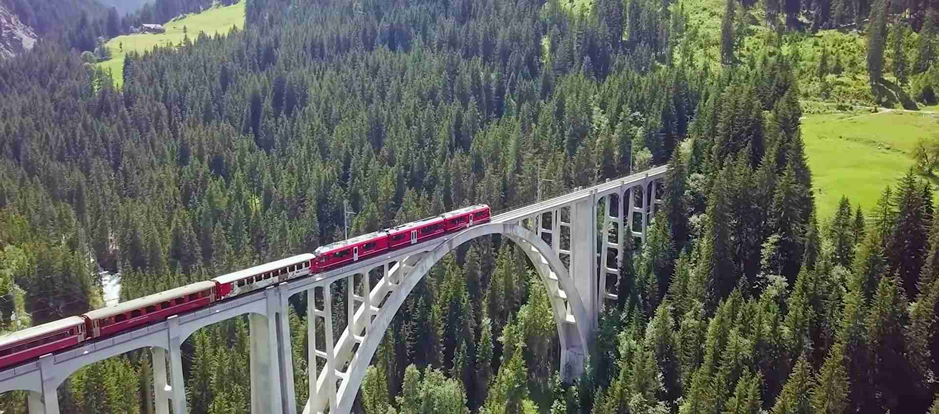
Rhaetian Railway UNESCO World Heritage Guide: Engineering Masterpiece Through the Swiss Alps
The Rhaetian Railway in the Albula/Bernina Landscapes represents one of the most spectacular achievements in mountain railway engineering, threading 122 kilometers of narrow-gauge track through the Swiss Alps without rack-and-pinion assistance. Inscribed as a UNESCO World Heritage Site in 2008, this transalpine railway system combines the Albula and Bernina lines into a seamless journey from Thusis through St. Moritz to Tirano, Italy, crossing dramatic passes, spiraling through mountains, and spanning deep gorges on stone viaducts that have become architectural icons.
Key Takeaways: Rhaetian Railway UNESCO World Heritage
- UNESCO Recognition and Engineering Excellence: The Rhaetian Railway in the Albula/Bernina Landscapes achieved UNESCO World Heritage status in 2008 under criteria (ii) and (iv), recognized as an outstanding technical, architectural, and environmental ensemble that exemplifies early 20th-century mountain railway development at high altitudes with lasting socio-economic impact on Alpine communities.
- Two Historic Lines Unified: The 67-kilometer Albula Line (Thusis to St. Moritz, opened 1904) and the 61-kilometer Bernina Line (St. Moritz to Tirano, opened 1910) together form a 122-kilometer UNESCO-designated route featuring 55 tunnels, 196 bridges, and spectacular engineering structures including the iconic Landwasser Viaduct and Brusio Spiral Viaduct.
- Highest Transalpine Railway: The Bernina Line reaches 2,253 meters above sea level at Ospizio Bernina, making it the highest railway crossing in Europe and one of the steepest adhesion railways in the world with gradients up to 7 percent, achieving dramatic elevation changes entirely through adhesion technology without rack-and-pinion systems.
- Innovative Spiral Engineering: The railway employs revolutionary spiral tunnels and helical loops that allow trains to gain or lose altitude within mountains, most famously demonstrated in the Bergün-Preda section where the train circles through the mountain at three different elevations and in the open-air Brusio Spiral Viaduct that makes a complete 360-degree curve.
- Landwasser Viaduct Architectural Icon: Standing 65 meters high and spanning 136 meters, the curved limestone Landwasser Viaduct ranks among the most photographed railway structures worldwide, constructed in 1901-1902 without scaffolding using innovative crane-based techniques, with its southeastern end connecting directly into the Landwasser Tunnel entrance carved into a vertical rock face.
- Living Heritage Railway: Unlike many heritage sites, the Rhaetian Railway remains a fully operational transportation system carrying both local commuters and tourists, with the infrastructure maintained to modern safety standards while preserving the authentic character of the early 20th-century engineering that earned its World Heritage designation.
People Also Ask About Rhaetian Railway UNESCO World Heritage
Why is the Rhaetian Railway a UNESCO World Heritage Site?
The Rhaetian Railway achieved UNESCO World Heritage status in 2008 because it represents an outstanding technical, architectural, and environmental ensemble that exemplifies early 20th-century solutions to mountain railway engineering challenges. The designation recognizes the railway’s innovative approach to overcoming the isolation of Central Alpine settlements through comprehensive and diversified engineering solutions that demonstrate substantial interchange of human and cultural values in mountain railway technology development. The railway’s harmonious integration with the dramatic Alpine landscapes through which it passes, combined with its lasting socio-economic impact on mountain life and its role in facilitating human activities in challenging high-altitude environments, qualified it under UNESCO criteria (ii) for cultural interchange and (iv) for exemplary illustration of mountain railway development.
How long is the Rhaetian Railway UNESCO section?
The UNESCO World Heritage-designated section of the Rhaetian Railway spans approximately 122 kilometers from Thusis to Tirano, comprising two distinct historic lines unified into a single transalpine route. The Albula Line measures 67 kilometers from Thusis to St. Moritz and includes 42 tunnels, covered galleries, and 144 viaducts and bridges. The Bernina Line covers 61 kilometers from St. Moritz to Tirano and features 13 tunnels and galleries plus 52 viaducts and bridges. Together, these sections create a continuous railway journey through two Alpine passes—the Albula and Bernina—connecting Switzerland with Italy while demonstrating exceptional engineering achievement across diverse mountain terrain.
What is special about the Landwasser Viaduct?
The Landwasser Viaduct stands as the most iconic structure on the Rhaetian Railway, renowned for its dramatic 65-meter height, 136-meter curved span, and unique connection directly into the Landwasser Tunnel entrance positioned on a vertical rock wall. Constructed between 1901 and 1902 by engineer Alexander Acatos, the viaduct employed revolutionary construction techniques for its era, building the limestone pillars around steel-reinforced cores using two cranes without traditional scaffolding. The six-arched structure carries a single railway track across the Landwasser gorge with a gradient of 2 percent, creating one of the most photographed railway scenes in the world as red trains emerge from mountain tunnels to cross the elegant limestone bridge before disappearing into another tunnel carved into sheer rock.
Can you visit the Rhaetian Railway without riding the train?
The Rhaetian Railway can be experienced through multiple viewing and hiking options beyond riding the trains themselves. The Landwasser Viaduct features two dedicated viewing platforms—one north of the structure offering tunnel entrance views and one south providing full viaduct perspectives—accessible via marked hiking trails from Filisur station. The Albula Railway Adventure Trail follows the railway line from Preda to Filisur, allowing hikers to walk alongside the tracks and observe engineering structures up close including spiral tunnels and viaducts. The Albula Railway Museum in Bergün provides comprehensive exhibits about railway history, construction techniques, and the UNESCO heritage designation, complete with historic artifacts and a driver’s cab simulator. Various hiking routes throughout the Albula and Bernina regions offer elevated viewpoints for photographing trains crossing viaducts and traversing mountain landscapes.
Introduction: Alpine Railway Engineering at Its Finest
The Swiss canton of Graubünden presented 19th-century railway engineers with seemingly insurmountable challenges: isolated mountain valleys separated by passes reaching above 2,000 meters, steep gradients that defied conventional railway construction, deep gorges requiring massive bridges, and harsh Alpine weather that threatened year-round operations. The Rhaetian Railway’s response to these challenges between 1898 and 1910 created a transportation system so innovative, so harmoniously integrated with its environment, and so influential on subsequent mountain railway development that UNESCO designated it a World Heritage Site nearly a century after its completion.
The railway that now carries the Bernina Express and regional services through the heart of the Swiss Alps began with the vision of Willem Jan Holsboer, a Dutch hotelier in Davos who recognized that connecting isolated Alpine communities would transform the region’s economic prospects. What emerged from his initiative became far more than a transportation link—it developed into an engineering laboratory where innovative solutions to mountain railway challenges were tested, refined, and proven, creating techniques that would influence railway construction throughout the world’s mountainous regions.
The UNESCO World Heritage designation encompasses 122 kilometers of railway between Thusis and Tirano, uniting two historic lines completed in the first decade of the 20th century. The Albula Line, opened in 1904, pioneered spiral tunnel technology and adhesion-based climbing that allowed trains to gain over 1,000 meters of elevation without rack-and-pinion assistance. The Bernina Line, completed in 1910, pushed these concepts even further, creating Europe’s highest transalpine railway crossing and one of the world’s steepest adhesion railways, descending from glacial heights to Mediterranean-climate valleys in a continuous journey that demonstrates extraordinary engineering versatility.
This recognition marked the first time UNESCO inscribed a railway line on its World Heritage List, acknowledging not just individual structures but an entire transportation system as a unified cultural and technical achievement. The inscription recognized the railway’s dual significance: as an outstanding example of civil engineering solutions to extreme topographical challenges, and as a catalyst for social and economic transformation that ended centuries of isolation for Alpine communities while establishing new relationships between human settlement and mountain environments.
More than a historical monument, the Rhaetian Railway remains a living heritage site where modern electric trains navigate the same curves, tunnels, and viaducts that steam locomotives conquered over a century ago. The railway continues serving both local transportation needs and international tourism, maintaining its infrastructure to contemporary safety standards while preserving the authentic engineering character that earned its World Heritage status. This dual function as working railway and protected heritage site creates unique management challenges and opportunities, requiring constant balance between operational efficiency, heritage preservation, and visitor access.
The landscape through which the railway passes adds another dimension to its significance. The Albula and Bernina regions encompass diverse Alpine ecosystems, from dense forests and Alpine meadows to barren glacial zones and rocky peaks exceeding 4,000 meters. The railway’s routing demonstrates exceptional sensitivity to these environments, threading through valleys, crossing gorges, and spiraling inside mountains in ways that minimize landscape disruption while maximizing the journey’s visual drama. This harmonious relationship between engineered infrastructure and natural setting became a central factor in UNESCO’s recognition, highlighting how the railway enhances rather than diminishes the Alpine landscape’s character.
UNESCO Inscription History and Criteria
The journey to UNESCO World Heritage status began decades before the formal application, rooted in growing recognition among railway historians and preservationists that the Albula and Bernina lines represented exceptional achievements worthy of international protection. By the 1990s, as similar early 20th-century railways worldwide faced abandonment or modernization that erased historic character, advocates within Switzerland recognized the Rhaetian Railway’s unique combination of technical innovation, architectural quality, landscape integration, and continued operational vitality.
The formal nomination process culminated in the 32nd session of the UNESCO World Heritage Committee meeting in Quebec City, Canada, where on July 7, 2008, the Rhaetian Railway in the Albula/Bernina Landscapes received inscription on the World Heritage List. This designation made the Rhaetian Railway the first railway line in the world to achieve this recognition, establishing precedent for how UNESCO would evaluate transportation infrastructure as cultural heritage. The inscription specifically designated the 122-kilometer section from Thusis through St. Moritz to Tirano, excluding other Rhaetian Railway lines that lacked the same historical significance and architectural cohesion.
UNESCO’s recognition rested on two specific criteria from the organization’s guidelines for cultural heritage evaluation. Criterion (ii) acknowledges sites that “exhibit an important interchange of human values, over a span of time or within a cultural area of the world, on developments in architecture or technology, monumental arts, town-planning or landscape design.” The Rhaetian Railway met this criterion through its comprehensive demonstration of innovative engineering solutions to mountain railway challenges, representing substantial interchange of technical and cultural values in early 20th-century railway development. The designation recognized how the railway’s architectural and civil engineering achievements, combined with their aesthetic harmony with Alpine landscapes, influenced mountain railway construction worldwide.
Criterion (iv) applies to sites that represent “an outstanding example of a type of building, architectural or technological ensemble or landscape which illustrates (a) significant stage(s) in human history.” The railway qualified under this criterion as an exceptional illustration of high-altitude mountain railway development during the critical first decade of the 20th century, representing consummate quality that proved instrumental in long-term mountain community development. UNESCO’s evaluation emphasized the railway’s role in facilitating human adaptation to challenging high-altitude environments and its contribution to the flourishing relationship between human settlement and Alpine nature during this transformative period.
The inscription recognized the railway’s integrity and authenticity despite more than a century of continuous operation. UNESCO’s evaluation noted that the railway infrastructure forms an authentic ensemble of great integrity, with technical operation and maintenance ensuring long-term high-quality conservation. The assessment acknowledged that the Rhaetian Railway company had introduced technical changes and innovations compatible with the concept of authenticity for technological properties still in use, balancing operational requirements with heritage preservation. This recognition established important precedent for evaluating working infrastructure as heritage, acknowledging that appropriate modernization could coexist with heritage protection.
The legal protection framework supporting the inscription combined Swiss federal heritage legislation, cantonal regulations specific to Graubünden, and the Rhaetian Railway company’s own conservation policies. The UNESCO evaluation deemed this multi-layered protection adequate while suggesting enhanced public presentation of the railway’s founding heritage aspects. The management system coordinates among the Rhaetian Railway, the RhB World Heritage Association, cantonal authorities, and Swiss federal heritage agencies, creating integrated oversight that addresses both operational railway needs and heritage conservation requirements.
Historical Development and Construction: Albula Line
The Albula Line’s history begins with Willem Jan Holsboer’s 1888 proposal for a railway from Landquart to Davos, driven by recognition that his hotel business and the broader regional economy suffered from isolation that limited year-round access to mountain communities. Initial plans envisioned standard-gauge construction, but the mountainous terrain’s constraints forced adoption of narrow-gauge technology, specifically the meter-gauge (1,000 millimeters) that would become the Rhaetian Railway’s standard.
The Landquart-Davos line opened in 1890, establishing the foundation for what would become an expanding network. Holsboer’s vision extended beyond connecting individual valleys—he conceived a comprehensive system that would link Graubünden’s isolated communities into a unified transportation network while connecting the canton to Switzerland’s main railway lines and ultimately to Italy. This ambitious scope required crossing the Albula Pass, a formidable barrier that had challenged travelers for centuries and presented unprecedented engineering challenges for railway construction.
Planning for the Albula Line commenced in the mid-1890s, with engineers confronting the fundamental challenge of gaining over 1,000 meters of elevation between Thusis and the Upper Engadine valley while maintaining gradients within the adhesion limits of conventional locomotives. The solution involved combinations of traditional valley-following routes, strategic tunnel locations, spiral tunnels that allowed trains to gain height within mountains, and carefully engineered viaducts that spanned gorges at optimal crossing points. This comprehensive approach balanced construction costs, operational efficiency, and engineering feasibility while creating a railway route that would prove both technically sound and visually dramatic.
Construction of the Albula Line began in 1898 with multiple work sites operating simultaneously along the planned route. The project employed thousands of workers, many recruited from Italy and Austria-Hungary to supplement local labor, creating temporary construction camps that housed workers under harsh Alpine conditions. The construction period from 1898 to 1903 witnessed numerous technical challenges overcome through innovative solutions: the Landwasser Viaduct’s construction without traditional scaffolding, the boring of the 5.864-kilometer Albula Tunnel under the Albula Pass, and the creation of spiral tunnels near Bergün that allowed the railway to climb inside the mountain through helical loops.
The Albula Line opened for passenger service in July 1903 when trains reached Celerina, with extension to St. Moritz completed in 1904. The 67-kilometer route incorporated 42 tunnels and covered galleries protecting against avalanches and rockfall, plus 144 viaducts and bridges of varying scales from small stream crossings to the monumental Landwasser Viaduct. This density of engineering structures—averaging more than one tunnel and two bridges per kilometer—reflected the extreme topography the railway confronted and the comprehensive engineering response that characterized the entire project.
Initial operations employed steam locomotives specifically designed for the narrow-gauge track and steep gradients, with compounds and other efficiency measures maximizing pulling power on the sustained climbs. The railway’s success in connecting previously isolated communities produced immediate economic and social impacts: year-round reliable transportation enabled winter tourism development in St. Moritz and other Upper Engadine resorts, agricultural products from mountain valleys gained access to wider markets, and seasonal isolation that had defined mountain life for centuries ended definitively. These transformations validated Holsboer’s vision and established the Albula Line as a model for subsequent mountain railway projects.
Electrification came in 1919, converting the Albula Line from steam to electric traction using direct current systems later replaced by the 11-kilovolt 16.7-hertz alternating current that remains standard across the Rhaetian Railway network. This transition eliminated the operational challenges of maintaining water supplies for steam locomotives at high altitudes, reduced tunnel ventilation requirements, and improved operational efficiency while transforming the railway’s environmental impact through elimination of coal smoke and cinders.
Historical Development and Construction: Bernina Line
The Bernina Line emerged from recognition that the Albula Line’s success in connecting the Upper Engadine to northern Switzerland created opportunity for extending railway access southward across the Bernina Pass to Italy. Unlike the Albula Line’s focus on connecting Swiss communities, the Bernina project aimed from inception to create a transalpine link providing direct rail connection between central Switzerland and the Valtellina region of Italy, opening new routes for both passenger and freight traffic while avoiding the circuitous existing routes through other Alpine passes.
Engineering challenges for the Bernina Line exceeded even those confronted on the Albula route. The railway needed to climb from St. Moritz at 1,775 meters to Ospizio Bernina at 2,253 meters, then descend nearly 1,800 meters to Tirano at 429 meters—creating the greatest elevation change on any Swiss railway. The descent section presented particular challenges, requiring gradients approaching the absolute limits of adhesion railway technology while maintaining safe operational speeds and adequate braking capacity for the steep sustained descents.
The engineering solution employed adhesion technology without rack-and-pinion assistance, achieving gradients up to 7 percent (70 per thousand) through combinations of valley-following routes, strategic use of spiral curves and switchback equivalents, and careful gradient management that alternated steeper and gentler sections to manage train speeds naturally. This approach created one of the steepest adhesion railways in the world while avoiding the operational complications and speed limitations inherent in rack railway systems.
Construction commenced in 1906 with the section from St. Moritz to Pontresina, advancing southward through progressively more challenging terrain. The project faced harsh Alpine weather that restricted construction to summer months in the highest sections, severe winter conditions that damaged partially completed structures, and logistical challenges in supplying remote work sites with materials and equipment. Workers endured extreme conditions, with high-altitude sections presenting particular hardships due to reduced oxygen, temperature extremes, and increased physical demands of working at elevations exceeding 2,000 meters.
The Bernina Line opened for passenger service on July 1, 1908, for the section between St. Moritz and Tirano, with full completion of all planned infrastructure achieved by 1910. The 61-kilometer route incorporated 13 tunnels and galleries plus 52 viaducts and bridges, achieving a lower density of major structures than the Albula Line but including several engineering landmarks that would become iconic symbols of Alpine railway construction. The railway’s routing prioritized scenic values alongside engineering efficiency, selecting alignments that showcased the dramatic landscape transitions between glacial high-altitude zones and the Mediterranean-climate valleys near Tirano.
The Bernina Line employed different electrification from the Albula route, using direct current systems that continue operating today, requiring trains to switch between electrical systems at St. Moritz. This technical difference reflects the Bernina Line’s independent origins and construction before integration into the unified Rhaetian Railway network, preserving operational distinction even as administrative and service integration unified the two lines into a single transalpine route.
Immediate impacts mirrored those experienced with the Albula Line: dramatic reduction in travel times between St. Moritz and Italian markets, year-round reliable service replacing seasonal and weather-dependent road transportation, and tourism development capitalizing on the railway journey’s scenic qualities. The Bernina Line particularly benefited Italian communities in the Valtellina, providing mountain resort access and creating new economic opportunities that transformed previously marginal agricultural regions into tourism destinations.
Landwasser Viaduct: Architectural Icon and Engineering Marvel
The Landwasser Viaduct stands as the Rhaetian Railway’s most photographed and internationally recognized structure, embodying the harmonious integration of bold engineering and Alpine landscape that characterizes the entire UNESCO World Heritage designation. Located at kilometer 63.070 from Thusis between the stations of Schmitten and Filisur, the viaduct carries the railway across the Landwasser gorge at a point where the valley narrows dramatically, with steep rock walls rising on both sides creating the natural setting for one of railway architecture’s most dramatic compositions.
Engineer Alexander Acatos designed the viaduct for the Rhaetian Railway, developing a structure that responded to the site’s specific constraints while pushing contemporary construction techniques to new levels of ambition. The curved alignment spanning 136 meters carries a single railway track at a constant gradient of 2 percent, supported on six limestone arches that rise 65 meters above the Landwasser river below. The southeastern end of the viaduct connects directly to the entrance of the 216-meter Landwasser Tunnel, carved into a vertical rock face in an alignment that required the tunnel entrance to begin on sheer cliff rather than at ground level.
Construction commenced in 1901 under the direction of the firm Müller & Zeerleder, employing innovative techniques that eliminated traditional wooden scaffolding for building the main piers. Instead, workers erected steel tower frames around which limestone masonry was constructed, with the limestone pillars built up around steel-reinforced cores that provided structural stability during construction and permanent reinforcement after completion. This approach allowed construction in the deep narrow gorge where traditional scaffolding would have been impractical to erect and prohibitively expensive, while also reducing construction time and material costs.
The construction process employed two crane systems positioned to serve different sections of the viaduct, lifting limestone blocks and construction materials to progressively higher levels as the piers grew. Workers built the limestone pillars with careful attention to aesthetic proportion, tapering the pier width toward the top to create visual elegance while maintaining structural adequacy. The six arches connecting the pier tops employed more conventional wooden formwork during construction, creating the curved limestone spans that support the track bed and give the structure its distinctive curved profile.
Completion in 1902 required approximately 13 months of construction time and consumed 12,033 cubic meters of limestone masonry, at a total cost of 280,000 Swiss francs (equivalent to approximately 7.8 million US dollars in 2014 values when adjusted for inflation). The rapid construction schedule and innovative techniques attracted contemporary attention from engineering professionals, establishing the Landwasser Viaduct’s reputation for technical excellence even before trains began regular service.
The viaduct’s visual drama stems from multiple factors working in combination. The curved alignment creates dynamic perspective changes as trains cross from one side to the other, with the structure’s arc visible in its entirety from both north and south viewing positions. The sudden appearance of trains emerging from the Landwasser Tunnel onto the viaduct, seemingly materializing from solid rock before crossing empty space above the gorge, creates cinematic moments that have made the structure a favorite subject for railway photographers and tourism marketing. The limestone construction in natural gray stone integrates harmoniously with the surrounding rock formations while providing sufficient contrast to remain visually distinct, and the structure’s proportions balance engineering boldness with architectural grace.
The tunnel entrance directly at the viaduct’s end, positioned on the vertical cliff face, represents exceptional coordination between viaduct and tunnel engineering. Workers boring the Landwasser Tunnel from inside the mountain had to align the tunnel entrance precisely with the viaduct’s southeastern end, requiring accurate surveying and construction control to ensure the connection would align correctly. The successful execution of this alignment, achieved with early 20th-century surveying technology, demonstrated the high level of engineering precision employed throughout the project.
Maintenance requirements for the Landwasser Viaduct remained minimal through its first century of service, testament to the quality of original construction and the durability of limestone in the Alpine environment. The first comprehensive renovation occurred in 2009, over a century after completion, when engineers repaired masonry joints and the track trough while preserving the structure’s historic character. This renovation demonstrated the careful balance required for maintaining heritage structures that remain operationally critical, employing modern materials and techniques where necessary for structural integrity while preserving historic fabric wherever possible.
Visitor access to the Landwasser Viaduct includes two primary viewing platforms installed specifically for photographers and railway enthusiasts. The northern platform, accessible via a 30-minute uphill walk from a parking area along the cantonal road between Alvaneu-Bad and Filisur, offers views encompassing both the viaduct and the tunnel entrance, positioned above the short Zalaint Tunnel approximately 200 meters from the viaduct. The southern platform, reached via a 30-minute walk from Filisur station, provides full viaduct views though the tunnel entrance remains hidden from this perspective. Both platforms feature safety barriers and information panels explaining the viaduct’s construction and significance.
Brusio Spiral Viaduct: Open-Air Helical Engineering
The Brusio Spiral Viaduct represents the Bernina Line’s most distinctive engineering structure, creating a complete 360-degree circular curve in open air that allows the railway to descend approximately 30 meters over a short horizontal distance while maintaining constant gradient within operational limits. Located between the village of Brusio and the border station of Campocologno on the descent toward Tirano, the viaduct solves a fundamental challenge in mountain railway design: how to achieve significant elevation change in limited space without exceeding safe operating gradients.
The spiral viaduct employs a circular curve with radius of approximately 70 meters, creating a helical descent path where the railway literally spirals around itself. Trains entering the structure at the higher northern end follow the curve through a complete circle, emerging at the lower southern end positioned beneath the entry point they crossed approximately one minute earlier. This three-dimensional routing allows the railway to descend the steep hillside at a controlled 7 percent gradient, avoiding the need for even steeper grades or complex switchback arrangements that would compromise operational efficiency.
Construction of the viaduct employed limestone masonry supporting nine arches of varying spans, creating an open structure that allows the landscape to remain visible beneath and through the railway. This transparency distinguishes the Brusio viaduct from the railway’s numerous spiral tunnels, where similar helical climbing or descending occurs inside mountains invisible to passengers and observers. The open-air construction transforms the engineering solution into architectural spectacle, making the railway’s three-dimensional routing comprehensible and creating visual drama as trains circle around and beneath themselves.
The architectural approach balances engineering function with aesthetic integration into the surrounding landscape. The limestone arches echo traditional Alpine architecture and engineering, connecting the structure to regional building traditions while serving purely functional structural purposes. The viaduct’s positioning on the hillside and its circular form create a landscape landmark visible from considerable distances, marking the railway’s presence without overwhelming the pastoral character of the Brusio valley. This sensitivity to landscape integration contributed to UNESCO’s recognition of the railway’s harmonious relationship with its Alpine setting.
Operational aspects of the Brusio viaduct create unique experiences for train passengers and observers. Passengers aboard trains traversing the spiral experience the unusual sensation of watching the landscape rotate through 360 degrees while feeling continuous descent, with views back toward the entry point becoming visible as the train completes its circle. The gradient and curve combination create physical sensations similar to aircraft takeoff or landing, including pressure changes perceptible as slight ear discomfort for some passengers. The complete circuit takes approximately 60 seconds at typical operating speeds, providing extended observation opportunities for the spiral’s engineering and the surrounding valley landscape.
Photography of the Brusio viaduct attracts railway enthusiasts from throughout the world, with the structure’s open circular form creating composition opportunities unavailable for linear viaducts or tunnel sections. The complete spiral becomes visible from elevated viewpoints on the hillside above the structure, allowing photographers to capture trains simultaneously crossing multiple levels of the viaduct as they spiral downward. The contrast between the red-painted modern railway cars and the gray limestone masonry creates strong visual impact, while the surrounding pastoral landscape of fields, forests, and mountains provides scenic context that enhances rather than competes with the architectural subject.
The viaduct’s position near Brusio makes it accessible for visitors traveling by train or road, with the village serving as a base for exploring the structure and surrounding region. Walking paths approach the viaduct from multiple directions, allowing close inspection of the limestone masonry and observation of trains from various angles including from inside the spiral looking outward. Information panels near the structure explain the engineering principles and historical context, connecting the Brusio viaduct to the broader UNESCO World Heritage designation and the Bernina Line’s comprehensive engineering achievement.
Spiral Tunnels and Helical Engineering Albula Line
The Albula Line’s greatest engineering innovation appears not in dramatic visible structures but in the invisible three-dimensional routing employed inside mountains, where spiral and helical tunnels allow the railway to gain altitude through circular climbing within the rock mass. This technique, pioneered on the Albula route and subsequently adopted by mountain railways worldwide, enables trains to climb steep mountain slopes at controlled gradients by extending the track length through internal loops and spirals rather than following direct but impossibly steep surface routes.
The classic demonstration of spiral tunnel technology occurs in the section between Bergün and Preda, where the railway climbs 416 meters of elevation over approximately 7 kilometers of horizontal distance. The track alignment follows the valley floor from Bergün, then enters a series of tunnels that spiral inside the mountain in helical paths climbing progressively higher. Trains emerge from these tunnels at various points along the mountainside, with the railway visible at three different elevations in views from Bergün, demonstrating how the spiral routing extends the horizontal distance traveled to maintain acceptable gradients for the vertical elevation gained.
The engineering principle underlying spiral tunnels derives from the fundamental relationship between gradient (vertical rise divided by horizontal distance) and the three-dimensional routing options available when boring through solid rock. Surface routes must follow terrain contours, limiting the horizontal distance available for gaining elevation and forcing steeper gradients. Tunnel routes liberate engineers from surface constraints, allowing horizontal distance to be extended through curves, loops, and spirals entirely within the mountain. This extension reduces effective gradient to levels compatible with adhesion locomotive operation, typically targeting maximum sustained gradients around 3.5 percent on the Albula Line’s steepest sections.
The Albula Line incorporates four major spiral tunnel complexes, each responding to specific topographical challenges along the route. These spirals range from relatively simple 180-degree curves to complete 360-degree helical loops, with the routing selected based on the elevation that needed to be gained, the mountain mass available for boring, and the positioning of tunnel portals at locations protected from avalanches and rockfall. The cumulative effect of these spiral sections allows the Albula Line to climb from Thusis at 697 meters to the Albula Tunnel entrance at 1,789 meters—a gain of over 1,000 meters—at gradients that conventional steam and later electric locomotives could manage without rack-and-pinion assistance.
Passenger experience of the spiral tunnels creates disorienting yet fascinating effects. Trains enter tunnels heading one direction, curve through darkness for extended periods sometimes exceeding several minutes, then emerge heading completely different directions at noticeably higher elevations. Windows on both sides of the train briefly show daylight as the spiral passes openings or short surface sections, then return to darkness as the tunnel continues its climbing curve. Particularly dramatic moments occur when trains emerge from spirals to cross visible viaducts before immediately re-entering tunnels, creating brief visual orientation opportunities that highlight how much elevation has been gained since entering the tunnel system.
The spiral tunnel between Bergün and Preda includes the famous moment where trains cross the Bergün viaduct, a structure positioned above the valley floor that trains pass beneath before entering a spiral tunnel. The tunnel climbs inside the mountain through a helical path, eventually emerging onto the same viaduct the train had previously viewed from below, creating the surreal experience of crossing a bridge that towers above a valley where the same train traveled minutes earlier. This vertical stacking of route levels within compact horizontal distance epitomizes the three-dimensional routing that spiral tunnels enable.
Construction of spiral tunnels required sophisticated surveying to ensure tunnels bored from multiple access points would align correctly when meeting inside the mountain. Workers boring from opposite ends of planned tunnel sections used careful measurement and theodolite sighting to maintain proper headings and gradients, with achievement of accurate alignment when tunnels met serving as validation of surveying precision and construction control. The successful completion of multiple spiral tunnels on the Albula Line demonstrated mastery of underground engineering techniques that would prove valuable for subsequent tunnel projects throughout the Alps and other mountainous regions.
Maintenance of spiral tunnels presents ongoing challenges due to the structures’ inaccessibility and the harsh conditions inside mountain environments. Water infiltration through rock fissures, temperature variations between seasons, and the continuous stress of train operations require regular inspection and periodic maintenance of tunnel linings, drainage systems, and track infrastructure. The Albula Line’s century of operation has required progressive strengthening and modernization of tunnel infrastructure, including the current construction of a new Albula Tunnel to replace the original 1903 structure while maintaining service continuity.
Engineering Features and Technical Innovations
The Rhaetian Railway’s UNESCO World Heritage designation recognizes a comprehensive ensemble of engineering solutions rather than isolated spectacular structures, acknowledging the systematic approach that addressed every aspect of mountain railway operation from route selection through construction techniques to operational systems. This comprehensive engineering response created a railway that functions reliably despite extreme topographical challenges, harsh Alpine weather, and operational requirements spanning from local commuter service to international tourism traffic.
The foundation of the railway’s engineering success lies in the narrow-gauge decision that allowed tighter curve radii and more flexible routing than standard-gauge railways could achieve. The 1,000-millimeter meter gauge employed throughout the Rhaetian network permitted minimum curve radii of 45 meters compared to the 150 meters or greater required for standard gauge, enabling the railway to follow mountain contours, spiral through tight helical tunnels, and navigate constrained valley sections that would have been impossible with broader gauge. This gauge selection represented fundamental engineering judgment that influenced every subsequent design decision.
Adhesion technology without rack-and-pinion assistance determined routing strategies and gradient management throughout both the Albula and Bernina lines. Maximum sustained gradients of 3.5 percent on the Albula Line and 7 percent on the Bernina Line approached the absolute limits of adhesion locomotive capability, requiring careful attention to track conditions, wheel-rail interface optimization, and braking system design. The successful operation of these steep adhesion sections demonstrated that rack railways, while useful for extremely steep sections, were not necessary for the gradients encountered on transalpine routes if engineers accepted longer distances through spiral routing and comprehensive gradient management.
Bridge and viaduct design throughout the railway reflected careful balancing of structural requirements, aesthetic considerations, and construction practicality. The 196 bridges crossing the Albula and Bernina routes range from small single-arch stream crossings to major multi-arch viaducts spanning deep gorges, with design approaches varying based on span length, height, foundation conditions, and available construction materials. Limestone masonry predominates for major structures including the Landwasser and Brusio viaducts, drawing on regional building traditions and local material availability while creating structures whose appearance harmonizes with surrounding rock formations.
Tunnel construction employed drilling and blasting techniques typical of early 20th-century practice, with workers advancing from multiple headings to accelerate completion and provide ventilation during construction. Tunnel linings varied from unlined sections through stable rock to full masonry or concrete lining in sections requiring support, with the engineering approach tailored to specific geological conditions encountered during boring. Portal locations received particular attention for protection against avalanches and rockfall, with covered galleries extending from tunnel entrances where necessary to shield tracks from winter hazards.
Protection against avalanches and rockfall required extensive gallery construction along both the Albula and Bernina lines, particularly on high-elevation sections exposed to winter snow accumulation and spring avalanche danger. These covered galleries function as elongated tunnels protecting the railway from overhead hazards while maintaining visual connection to surrounding landscapes through periodic openings. The Bernina Line between Ospizio Bernina and Alp Grüm employs particularly extensive gallery systems including the 140-meter Scala Gallery, 192-meter Scala Tunnel, and 348-meter Sassal Mason Gallery, collectively protecting the railway through sections severely affected by avalanche and drifting snow.
Electrification systems supporting the railway’s operation employ two different standards reflecting the lines’ independent origins and construction. The Albula Line uses 11-kilovolt 16.7-hertz alternating current, matching standard Swiss railway electrification, while the Bernina Line operates on direct current systems. This technical difference requires trains to switch between electrical systems at St. Moritz, with locomotives designed to operate on both systems or requiring locomotive changes for through service. Modern electric multiple units employed on both lines handle the dual-system requirement through onboard equipment that automatically adapts to the electrical system encountered.
Signaling and train control systems maintain safe operations despite the challenging terrain, limited visibility through curved sections and tunnels, and the need to manage trains on steep gradients where braking distances exceed those on level railways. Modern implementations employ track circuits, automatic train protection systems, and centralized traffic control from dispatching centers monitoring train positions and controlling switches and signals remotely. These contemporary systems operate within the physical infrastructure constraints established by the original railway alignment, creating integration challenges addressed through careful system design and installation techniques that preserve historic structures while meeting modern safety standards.
Landscape Integration and Environmental Harmony
UNESCO’s inscription of the Rhaetian Railway recognized not just engineering achievement but the harmonious relationship between the railway infrastructure and the Alpine landscapes through which it passes, acknowledging how the route selection, structure design, and operational character enhance rather than diminish the natural and cultural landscape qualities. This recognition of landscape integration as heritage value established important precedent for evaluating transportation infrastructure projects, highlighting that sensitive design can create infrastructure that contributes positively to landscape character.
The railway’s routing demonstrates exceptional sensitivity to landscape structure and visual quality, following valley floors where topography permits, climbing mountainsides through spiral tunnels that minimize surface scarring, and crossing gorges at points where viaducts appear as natural extensions of the landscape rather than alien intrusions. The engineers’ decisions about where to place tracks, tunnels, and bridges reflected not just technical optimization but also aesthetic judgment about how structures would appear within their settings and how the railway journey would reveal landscape qualities to passengers.
The Albula Line’s passage through the narrow Landwasser gorge exemplifies this landscape sensitivity. Rather than blasting a shelf into the gorge walls for continuous surface routing, engineers chose to thread the railway through a series of short tunnels interrupted by bridge crossings including the Landwasser Viaduct, creating a journey that alternates between enclosed tunnel sections and dramatic open moments above the gorge. This approach minimized landscape disruption while creating a more dynamic passenger experience than continuous surface routing would have provided, demonstrating how technical solutions and landscape considerations could reinforce rather than conflict with each other.
The Bernina Line’s high-altitude routing across open Alpine landscapes employed different landscape strategies suited to the more exposed terrain. Long open sections afford continuous views across glacial valleys, allowing passengers to observe landscape transitions from lower valley forests through treeline to barren high-altitude zones and back down to the Mediterranean-climate vegetation near Tirano. The railway’s positioning in these open sections maintains relatively low profile, following natural terrain contours and avoiding unnecessary embankments or cuttings that would create visual scars across the smooth Alpine slopes.
Structure design reflected conscious attention to visual integration beyond pure engineering functionality. The limestone masonry employed for major viaducts including the Landwasser and Brusio structures creates visual continuity with surrounding rock formations and traditional Alpine building materials, establishing the structures as culturally appropriate responses to their settings rather than technologically alien impositions. The tapering profiles of viaduct piers and the curved alignments of many bridges create visual grace that softens the structures’ engineering boldness, helping them appear as natural extensions of the landscape rather than dominating intrusions.
The railway’s influence on landscape perception operates bidirectionally: the structures become landscape elements that contribute to the overall scenic character, while the journey itself creates new ways of experiencing and understanding the Alpine environment. Passengers gain perspectives on mountains, valleys, and glaciers unavailable from roads or hiking trails, with the railway’s routing deliberately showcasing dramatic landscape features through careful alignment choices. This designed landscape revelation transforms the journey into interpretive experience, helping passengers understand landscape structure, geological processes, and the relationship between topography and human settlement patterns.
Environmental impacts of the railway’s construction and operation have evolved significantly from the original early 20th-century conditions. Initial construction created temporary disruption through excavation, material transport, and worker camp establishment, with these impacts largely healed through natural revegetation and intentional landscape restoration. The conversion from steam to electric traction eliminated coal smoke and ash that had marked the railway’s passage through sensitive Alpine environments, while also reducing forest fire risk from locomotive sparks that had threatened slopes adjacent to the railway during the steam era.
Contemporary operations maintain environmental awareness through multiple management systems addressing noise, waste, water quality, and landscape preservation. The railway’s continued function as primary public transportation for many Alpine communities contributes to reduced automobile traffic and associated environmental impacts, positioning the heritage railway as environmentally beneficial infrastructure rather than merely preserved historical artifact. This environmental contribution adds contemporary relevance to the UNESCO heritage designation, demonstrating how 20th-century infrastructure can serve 21st-century sustainability goals.
Socio-Economic Impact and Mountain Community Development
The railway’s UNESCO inscription under criterion (ii) specifically recognized its role in facilitating “substantial interchanges of human and cultural values” and under criterion (iv) acknowledged it as “instrumental in the long-term development of human activities in the mountains,” highlighting how the transportation infrastructure transformed economic possibilities and social organization for Alpine communities. These transformations constitute heritage values equal to the engineering achievement, recognizing that cultural significance extends beyond physical structures to encompass social and economic impacts.
Prior to the railway’s construction, Alpine communities faced seasonal isolation that fundamentally shaped economic activities, social patterns, and cultural development. Winter closure of high mountain passes restricted communication and commerce to the snow-free months between approximately May and October, forcing communities to maintain self-sufficiency in food production and other essential goods while limiting market access for agricultural products, craft goods, and other potential exports. This isolation also restricted population mobility, constraining opportunities for education, employment diversity, and cultural interchange that characterized more accessible regions.
The railway’s year-round reliable operation through the Albula and Bernina passes ended this seasonal isolation definitively, creating permanent transportation links that functioned regardless of weather conditions. Winter tourism development in St. Moritz and other Upper Engadine resorts became possible only with reliable winter access, transforming communities that had previously endured quiet months of limited activity into year-round destinations where winter sports and luxury tourism created employment and income opportunities unknown in the pre-railway era. This winter tourism development fundamentally altered regional economic structure, shifting emphasis from agriculture and summer Alpine pasturing to service-sector employment in hotels, restaurants, ski operations, and related businesses.
Agricultural impacts extended beyond tourism development to encompass market access for traditional products. Alpine dairy production gained reliable connection to urban markets, allowing cheese and other dairy products to reach consumers while fresh rather than requiring preservation for transport on seasonal pack animal caravans. Timber harvesting and forest product industries similarly benefited from railway freight capacity that exceeded what draft animals could transport, enabling commercial-scale forest management where previously only subsistence-level harvest was practical.
The railway’s influence on settlement patterns and population distribution created new demographic realities throughout the regions it served. Communities located on the railway line experienced population growth and economic diversification, while valleys lacking railway access faced relative decline as residents migrated to areas offering greater economic opportunity. This concentration of development along the railway corridor created the linear urbanization pattern still visible today, with continuous development following the railway alignment through formerly dispersed settlement areas.
Educational and cultural impacts paralleled economic transformation, with railway access enabling students to attend distant schools and universities, facilitating cultural organizations’ development through easier travel for performers and audiences, and supporting newspaper distribution and communication systems that reduced the intellectual isolation Alpine communities had historically experienced. These cultural changes contributed to integration of previously remote regions into broader Swiss and European society, ending the cultural distinctiveness that isolation had preserved while creating new opportunities for cultural exchange and development.
The railway’s economic impact extended into Italy through the Bernina Line’s connection to Tirano and the Valtellina, creating direct links between Swiss and Italian markets that bypassed traditional trade routes and altered commercial relationships. Italian agricultural products gained access to Swiss consumers while Swiss manufactured goods found new markets across the border, with the railway facilitating bilateral commerce that strengthened economic ties between regions that had historically maintained limited interaction.
Contemporary socio-economic significance of the railway continues through its dual function as heritage tourism attraction and essential local transportation infrastructure. Approximately 80 percent of passenger revenue derives from tourist traffic, particularly the Bernina Express and Glacier Express scenic services that market the railway’s landscape and engineering values to international audiences. The remaining 20 percent represents local commuters whose access to employment, education, and services depends on the railway’s continued operation, positioning the heritage infrastructure as living working system rather than museum piece.
Conservation, Preservation, and Heritage Management
Managing the Rhaetian Railway as UNESCO World Heritage Site while maintaining its function as operational transportation infrastructure creates complex challenges requiring balance between preservation of historic character, achievement of contemporary safety and operational standards, and accommodation of tourism pressures that World Heritage designation intensifies. The solutions developed by the Rhaetian Railway company and the RhB World Heritage Association provide models for heritage management of working infrastructure worldwide.
Legal protection for the railway combines multiple regulatory frameworks operating at federal, cantonal, and company levels. Swiss federal heritage legislation establishes baseline protection for structures and landscapes of national significance, while cantonal regulations specific to Graubünden provide additional controls over modifications to heritage-designated infrastructure. The Rhaetian Railway company’s internal policies commit to heritage preservation beyond minimum legal requirements, recognizing that World Heritage status creates reputational obligations exceeding regulatory compliance.
The RhB World Heritage Association coordinates heritage management activities among the multiple stakeholders including the railway company, cantonal and federal heritage authorities, tourism organizations, and local communities. This coordination addresses both physical infrastructure preservation and intangible heritage values including railway operations knowledge, maintenance traditions, and the cultural significance of the railway within Alpine society. The association’s work includes developing educational programs, supporting research on railway history and engineering, and promoting public understanding of the heritage values that earned UNESCO recognition.
Infrastructure maintenance and modernization within heritage constraints requires careful evaluation of every proposed change, balancing operational requirements against preservation priorities. Modern safety requirements sometimes conflict with historic character, requiring negotiated solutions that achieve acceptable safety levels while minimizing visible alterations to heritage structures. Examples include installation of modern signaling equipment using designs that blend with historic architecture, track renewal employing materials and techniques compatible with century-old viaducts and tunnels, and avalanche protection structures positioned to avoid visual impact on historically significant landscape views.
The Albula Tunnel renewal project demonstrates these heritage management challenges at large scale. The original 5.864-kilometer tunnel completed in 1903 required comprehensive renovation to address structural deterioration and accommodate modern operational requirements. Rather than closing the tunnel for extended renovation that would sever the railway’s continuity, engineers chose to bore a completely new tunnel adjacent to the historic structure, maintaining service during construction and creating backup capacity for future maintenance. This solution protected the historic tunnel from destructive renovation while ensuring service continuity, though at substantially higher cost than in-place renovation would have required.
Tourism management associated with World Heritage designation requires controlling visitor numbers at sensitive locations while providing appropriate access for public appreciation of heritage values. The Landwasser Viaduct viewing platforms exemplify managed access, concentrating visitors at specifically designed locations rather than allowing uncontrolled dispersal across the landscape. This concentration protects vegetation and landscape character in areas adjacent to viewpoints while ensuring visitor safety and providing interpretive information that enhances understanding of heritage significance.
Climate change impacts on Alpine railways create emerging conservation challenges requiring long-term planning and adaptive management. Increased rockfall risk from permafrost thaw, altered avalanche patterns as snowfall timing and volume change, and extreme weather events exceeding historical precedents all threaten infrastructure designed for climate conditions that may no longer prevail. Heritage management must address these challenges while preserving historic character, potentially requiring protective measures that alter landscape character around heritage structures but prevent their destruction through natural hazards.
Documentation and archival preservation support conservation by recording existing conditions, past modifications, and the evolution of railway technology and operations over time. The Rhaetian Railway maintains extensive archives including original construction drawings, engineering calculations, maintenance records, and photographic documentation spanning over a century of operations. This archival material provides baseline information for conservation planning and serves research supporting understanding of early 20th-century railway engineering and mountain transportation history.
Visitor Experience and Journey Options
The Rhaetian Railway functions simultaneously as heritage site and active transportation system, creating visitor experience opportunities ranging from the premium Bernina Express panoramic service to local trains serving commuters alongside tourists. Understanding the service options, route variations, and optimal travel strategies enhances appreciation of both the railway’s heritage significance and the Alpine landscapes through which it passes.
The Bernina Express represents the flagship tourist service, employing dedicated panoramic cars with oversized windows extending into the roof structure providing unobstructed views of the surrounding mountains, valleys, glaciers, and railway structures. This service operates the complete Chur to Tirano route in approximately four hours, with mandatory seat reservations required in addition to regular railway tickets. The panoramic cars include audio guide systems providing commentary about landscape features, engineering structures, and historical context in multiple languages, enhancing passenger understanding of the journey’s significance.
Regional train services operate the same routes without panoramic cars or mandatory reservations, using standard Rhaetian Railway rolling stock with conventional windows and more frequent station stops. These services allow flexible boarding and alighting along the route, supporting both local transportation needs and tourists preferring to explore specific locations rather than completing the full journey in single continuous travel. Regional trains typically take slightly longer than the Bernina Express for the complete route, with journey times around four and a half hours reflecting additional station stops.
The Glacier Express represents another premium service option, connecting Zermatt in the Valais with St. Moritz via the Oberalp Pass, with the section from Chur to St. Moritz utilizing the Albula Line infrastructure included in the UNESCO World Heritage designation. This service emphasizes leisurely travel with onboard dining service, though it covers different territory than the Bernina Express and does not traverse the Bernina Pass or descend into Italy. Travelers combining both routes can experience comprehensive Alpine railway diversity but must plan connections at Chur or St. Moritz.
Route selection influences the journey experience significantly, with different options prioritizing various aspects of the railway’s heritage and landscape values. The complete Chur to Tirano route includes both the Albula Line’s tunnel-intensive engineering and the Bernina Line’s open high-altitude panoramas, providing comprehensive experience of the UNESCO-designated railway’s diversity. Travelers with limited time might choose the St. Moritz to Tirano section focusing exclusively on the Bernina Line’s more consistently dramatic open landscape views and the descent through climate zones from glacial heights to Mediterranean valley.
Optimal seating positions vary by route section and travel direction, with right-side and left-side windows offering different views depending on the railway’s alignment relative to major landscape features. Southbound travel from Chur toward Tirano generally favors right-side seating for views across valleys toward mountains, though the most dramatic individual moments including the Landwasser Viaduct crossing appear on both sides as the train curves. Northbound travel reverses these priorities, with left-side seating often preferred for mountain views, though passengers should recognize that the route’s numerous curves ensure both sides receive interesting views throughout the journey.
Station stops along the route provide opportunities for extending the journey through multi-day exploration, with several locations offering particular interest for understanding the railway’s heritage significance and the Alpine landscape context. Filisur serves as base for visiting the Landwasser Viaduct on foot via marked trails from the station, while Bergün hosts the Albula Railway Museum providing comprehensive exhibits about railway construction, engineering, and heritage designation. Alp Grüm offers unique access to the Palü Glacier viewpoint and represents one of the few railway stations accessible only by train or foot, creating isolation that enhances the high-altitude Alpine experience.
Ticketing options include standard point-to-point tickets, Swiss Travel Passes providing unlimited travel on Swiss railways including the Rhaetian Railway’s regional services, and the dedicated UNESCO World Heritage Pass offering two days of unlimited travel on the Albula and Bernina lines. The UNESCO pass specifically targets travelers prioritizing exploration of the World Heritage railway, allowing multiple journeys and station stops without individual ticket purchase, facilitating comprehensive experience of the designated sections.
Photography opportunities along the route attract enthusiasts documenting the railway’s structures, rolling stock, and landscape integration. Interior photography from moving trains captures landscape views and the passenger experience, while external photography requires strategic planning to photograph trains crossing viaducts, emerging from tunnels, or traversing dramatic landscape sections. The Landwasser Viaduct viewing platforms and similar designated locations along the route provide optimal external photography positions, though photographers should verify train schedules to ensure trains will pass during their visit.
Albula Railway Museum and Educational Resources
The Albula Railway Museum in Bergün provides the most comprehensive public interpretation of the Rhaetian Railway’s engineering, history, and UNESCO heritage significance, occupying a historic railway building directly adjacent to Bergün station on the Albula Line. The museum’s location within the World Heritage railway corridor creates direct connection between exhibits and the infrastructure they document, allowing visitors to observe actual railway operations while learning about engineering principles and historical development.
The museum’s exhibits span four floors within the historic building, progressing from railway construction history through engineering technical details to contemporary operations and UNESCO heritage management. Ground floor exhibits introduce visitors to the Albula Line’s construction history through photographs, documents, and artifacts from the 1898-1903 construction period, establishing context for understanding the technical innovations and challenges that subsequent floors explore in detail.
Engineering exhibits on upper floors employ interactive displays, scale models, and multimedia presentations explaining spiral tunnel routing principles, viaduct construction techniques, and the relationship between gradient, curve radius, and train performance. A particular strength lies in the museum’s presentation of three-dimensional routing concepts, using physical models and computer animations to illustrate how spiral tunnels allow trains to gain altitude through helical paths inside mountains. These presentations make abstract engineering concepts comprehensible to visitors without technical backgrounds, supporting public understanding of the railway’s engineering significance.
The driver’s cab simulator represents the museum’s most popular interactive element, allowing visitors to experience operating a train through the Bergün to Preda section including the challenging spiral tunnel navigation and gradient management required for ascending or descending this steep route. The simulator employs actual control equipment and realistic track profiles providing authentic operating experience, giving visitors direct appreciation for the skill required to operate trains on mountain railways while highlighting the engineering that makes such operations possible.
Temporary exhibitions supplement the permanent collection, addressing specific aspects of railway history, contemporary operations, or heritage management in greater depth than permanent exhibits accommodate. Recent temporary exhibitions have explored the Albula Tunnel renewal project, the World Heritage designation process and its implications for railway operations, and profiles of key individuals in the railway’s development including founder Willem Jan Holsboer and chief engineers who designed major structures.
Educational programs developed by the museum serve school groups, railway enthusiasts, and general public audiences, with formats ranging from guided tours to hands-on workshops and lectures by railway historians and engineers. Programs for school groups align with Swiss educational curricula in history, geography, and technology, positioning the museum as educational resource supporting formal education while serving general tourism. Special programs for railway enthusiast groups provide technical depth exceeding general museum content, including access to archival materials and behind-the-scenes railway facilities not typically open to public visitors.
The museum shop offers publications about railway history, engineering, and Alpine transportation, along with railway-themed merchandise and historically significant reproductions. The publication collection includes technical monographs about specific engineering challenges and solutions, photographic histories documenting the railway’s evolution, and guide books for exploring the UNESCO World Heritage route. These resources support continued learning beyond the museum visit, helping visitors deepen understanding of topics introduced through exhibits.
Photography Guide: Capturing the Railway’s Dramatic Character
The Rhaetian Railway’s combination of distinctive red rolling stock, dramatic stone structures, and spectacular Alpine landscapes creates exceptional photographic opportunities attracting railway photographers, landscape artists, and general tourists seeking memorable images of Swiss mountain scenery. Successful photography requires understanding optimal locations, lighting conditions, seasonal variations, and techniques for capturing both technical details and landscape context.
The Landwasser Viaduct represents the railway’s most photographed location, with the southern and northern viewing platforms providing the primary access points for capturing trains crossing the curved limestone structure with the tunnel entrance visible in composition. The northern platform above the Zalaint Tunnel offers comprehensive views including the full viaduct arc and the Landwasser Tunnel entrance, allowing photographers to capture trains emerging from the mountain onto the viaduct before disappearing into another tunnel. Morning light generally favors the northern platform, with east-facing exposure receiving direct sunlight that illuminates the viaduct’s limestone while creating dramatic shadows in the gorge below.
The southern platform provides alternative perspectives emphasizing the viaduct’s height and the relationship between the railway and the Landwasser gorge, though the tunnel entrance remains hidden from this angle. Late afternoon light works best for this position, with west-facing exposure creating warm tones on the limestone as the sun approaches the horizon. Both platforms require advance planning regarding train schedules, as the dramatic moment of a train crossing the viaduct lasts only approximately 30 seconds, necessitating precise timing for capturing trains at optimal positions within the composition.
The Brusio Spiral Viaduct offers different photographic challenges and opportunities, with the complete circular structure visible from elevated positions on the hillside above. The ideal viewpoint positions photographers above and slightly outside the viaduct’s circle, allowing capture of the complete spiral with trains visible at multiple levels as they curve around the structure. Late morning through early afternoon lighting works well for this location, providing relatively even illumination across the entire circular viaduct without excessive shadows that would obscure portions of the structure.
The Bernina Pass high-altitude sections including Ospizio Bernina and the approach to Alp Grüm provide opportunities for photographing trains against glacial and mountain backdrops, with the Morteratsch and Palü glaciers creating dramatic context. These locations benefit from stable weather and clear skies that become more likely during autumn months September through October, when summer storm patterns subside but winter snow has not yet accumulated heavily. The high-altitude light quality creates particularly saturated colors in Alpine vegetation and intensifies the blue tones in glacial ice and mountain lakes.
The Albula Line’s spiral tunnel sections near Bergün present challenges for external photography due to the railway’s primarily subterranean routing, though the moments when trains emerge from tunnels onto visible viaducts create dramatic opportunities. Local knowledge of viewing positions improves success rates, with several locations near Bergün offering perspectives on trains crossing viaducts at different elevations as they spiral upward toward Preda. Winter conditions with snow coverage transform these scenes, creating high-contrast compositions of red trains against white landscapes with the dark tunnel portals providing additional graphic elements.
Seasonal considerations significantly influence photographic results, with each season offering distinct advantages and challenges. Winter photography benefits from snow coverage that simplifies compositions and increases contrast between trains and landscape, while creating challenges through reduced daylight hours, difficult hiking access to viewpoints, and weather conditions that can obscure mountains and create flat lighting. Summer provides maximum accessibility and reliable weather but sometimes delivers hazy atmospheric conditions that reduce landscape clarity, while autumn combines good weather probability with reduced tourist traffic and enhanced landscape colors from changing vegetation.
Interior photography from moving trains captures the passenger experience and landscape views through windows, though technical challenges include movement blur, reflections in glass, and compositional constraints imposed by window frames and positions. Wide-angle lenses work well for capturing landscape panoramas and the interior character of panoramic cars, while telephoto lenses allow compression of distant mountain scenes and selective focus on specific landscape features. Polarizing filters reduce window reflections when shooting through glass while also enhancing sky saturation and managing contrast in high-altitude bright conditions.
Telephoto photography from stationary positions allows detailed capture of trains as graphic elements moving through landscape, with focal lengths from 200-400mm compressing perspective to emphasize relationships between trains, structures, and mountain backgrounds. These techniques work particularly well at locations where trains pass at moderate distances from viewpoints, allowing photographers to isolate specific compositional elements while excluding foreground distractions. The Bernina Line’s open high-altitude sections provide numerous opportunities for this approach, with trains visible against mountain and glacier backgrounds.
Historical railway equipment operations including vintage steam trains scheduled periodically on the Albula Line create special photography opportunities, with the steam locomotives and period rolling stock providing authentic historical character that modern electric services cannot match. These special services typically operate during summer months on announced schedules, allowing photographers to plan specifically for capturing steam operations against the historic structures and Alpine landscapes that formed the original context for the railway’s construction.
Frequently Asked Questions About Rhaetian Railway UNESCO World Heritage
When was the Rhaetian Railway designated a UNESCO World Heritage Site?
The Rhaetian Railway in the Albula/Bernina Landscapes received UNESCO World Heritage designation on July 7, 2008, during the 32nd session of the UNESCO World Heritage Committee meeting in Quebec City, Canada. This inscription made the Rhaetian Railway the first railway line in the world to achieve UNESCO World Heritage status, establishing precedent for evaluating transportation infrastructure as cultural heritage. The designation specifically covers the 122-kilometer section from Thusis through St. Moritz to Tirano, comprising the Albula Line (opened 1904) and the Bernina Line (opened 1910), but excludes other portions of the broader Rhaetian Railway network that lack the same historical significance and architectural cohesion.
How high does the Rhaetian Railway climb?
The Bernina Line reaches its maximum elevation of 2,253 meters (7,392 feet) above sea level at Ospizio Bernina station, making it the highest railway crossing in Europe and the third-highest railway in Switzerland. From this summit point, the railway descends nearly 1,800 vertical meters to reach Tirano, Italy at 429 meters above sea level, creating the greatest elevation difference on any Swiss railway and requiring extraordinary engineering to maintain safe operating gradients. The Albula Line climbs from Thusis at 697 meters to the Albula Tunnel entrance at 1,789 meters, gaining over 1,000 meters through combinations of spiral tunnels and valley-following routes before crossing under the Albula Pass to reach St. Moritz at 1,775 meters elevation.
Why doesn’t the Rhaetian Railway use rack-and-pinion technology?
The Rhaetian Railway achieves its dramatic elevation changes entirely through adhesion technology—the friction between steel wheels and steel rails—without requiring rack-and-pinion cog systems, demonstrating exceptional engineering achievement in route selection and gradient management. Maximum gradients of 7 percent on the Bernina Line approach the absolute limits of adhesion railway capability but remain within what properly designed locomotives and careful operational practices can manage safely. The engineers chose to extend route distance through spiral tunnels, helical curves, and valley-following alignment rather than accept the operational speed limitations, mechanical complexity, and reduced capacity inherent in rack railway systems. This adhesion-only approach allowed higher operational speeds, greater freight capacity, and operational simplicity compared to mixed adhesion-rack systems, while demonstrating technical sophistication that influenced subsequent mountain railway projects worldwide.
Can you ride the Rhaetian Railway year-round?
The Rhaetian Railway operates comprehensive year-round service on both the Albula and Bernina lines, providing reliable transportation regardless of season or weather conditions unlike the historic road passes that close during winter months. Regional trains run at regular intervals throughout the year serving local transportation needs, while the premium Bernina Express panoramic service operates daily with increased frequency during summer peak season. Winter operations employ specialized snow removal equipment including historic steam rotary snowplows and modern electric rotary plows that clear tracks after heavy snowfall, sometimes creating operational spectacles that attract railway enthusiasts documenting snow clearing operations. The railway’s extensive avalanche protection galleries and sophisticated hazard management systems including controlled avalanche triggering allow safe operation even when surrounding roads and hiking trails remain closed due to winter conditions.
What is the difference between the Bernina Express and regular trains?
The Bernina Express employs dedicated panoramic cars featuring oversized windows extending into the roof structure providing superior landscape views, mandatory seat reservations, onboard audio guide commentary in multiple languages, and premium pricing reflecting the enhanced tourist experience, while regular regional trains use standard Rhaetian Railway rolling stock with conventional windows, no reservation requirements, and standard Swiss railway fares. Both services traverse identical routes using the same tracks and infrastructure, so passengers see the same landscape and engineering features regardless of which service they choose. Regular trains make more frequent station stops and allow flexible boarding and alighting without reservations, better supporting travelers who want to explore specific locations or break their journey at intermediate points. The Bernina Express prioritizes the complete through journey as a dedicated tourism experience, making limited stops at major stations and treating the four-hour Chur to Tirano route as a single unified experience rather than transportation between endpoints.
How many tunnels and bridges are on the UNESCO railway section?
The UNESCO World Heritage-designated 122-kilometer section from Thusis to Tirano incorporates 55 tunnels and covered galleries plus 196 viaducts and bridges, creating an extraordinary density of engineering structures averaging more than two major structures per kilometer of route. The Albula Line contributes 42 tunnels and galleries along with 144 viaducts and bridges across its 67-kilometer length, while the Bernina Line adds 13 tunnels and galleries plus 52 viaducts and bridges along its 61-kilometer route. These structures range from small single-arch stream crossings and short protective galleries to major landmarks including the 5.864-kilometer Albula Tunnel, the 65-meter-high Landwasser Viaduct, and the unique circular Brusio Spiral Viaduct, collectively demonstrating the comprehensive engineering response required to create a functional railway through extreme Alpine topography.
Where can I learn more about the railway’s engineering?
The Albula Railway Museum in Bergün provides the most comprehensive public interpretation of the railway’s engineering, history, and UNESCO heritage significance, featuring interactive exhibits, scale models, multimedia presentations, and a driver’s cab simulator allowing visitors to experience operating trains through the challenging Bergün to Preda spiral tunnel section. The museum occupies a historic railway building directly adjacent to Bergün station on the Albula Line, creating direct connection between exhibits and the actual infrastructure they document. Beyond the museum, several viewing platforms along the route including those at the Landwasser Viaduct include interpretive panels explaining engineering features, while the Rhaetian Railway’s official website provides detailed information about heritage designation, engineering innovations, and ongoing conservation efforts including virtual tours and downloadable educational materials supporting independent research and learning.
What makes the spiral tunnels special?
The spiral and helical tunnels employed throughout the Albula Line represent revolutionary three-dimensional routing that allowed the railway to gain altitude by extending horizontal track distance through circular and helical paths inside mountains rather than following impossibly steep direct surface routes. This technique enables trains to climb at controlled gradients typically around 3.5 percent by literally spiraling upward inside mountain masses, sometimes passing beneath or above their own previous path at different elevations within the same tunnel complex. The classic demonstration occurs between Bergün and Preda where trains climb 416 meters through a series of spiral tunnels visible at three different elevations from Bergün, creating the surreal experience of crossing a viaduct, entering a tunnel, spiraling upward inside the mountain through darkness, then emerging onto the same viaduct now positioned far below. This spiral tunnel technology pioneered on the Albula Line influenced mountain railway construction worldwide and represents the engineering innovation that made adhesion-only climbing feasible on transalpine routes.
Is the railway still being maintained and improved?
The Rhaetian Railway maintains comprehensive ongoing maintenance, modernization, and infrastructure renewal programs balancing operational requirements with UNESCO heritage preservation obligations, ensuring the railway continues functioning reliably as both transportation system and protected cultural heritage. Current major projects include construction of a new Albula Tunnel to replace the original 1903 structure while maintaining service continuity, comprehensive viaduct strengthening programs including the Landwasser Viaduct’s first renovation in 2009, installation of modern signaling and train control systems meeting contemporary safety standards, and rolling stock renewal introducing new electric multiple units designed for the specific operational challenges of mountain railway service. All modifications undergo heritage review ensuring compatibility with UNESCO World Heritage status, with solutions developed that achieve necessary technical improvements while preserving the historic character and authentic engineering ensemble that earned the railway’s international recognition as outstanding cultural achievement.
Can I hike along the railway route?
Multiple marked hiking trails follow portions of the railway route, providing opportunities to observe engineering structures at close range, experience the Alpine landscapes from pedestrian perspectives complementing the train journey views, and visit dedicated viewpoints for photographing trains crossing viaducts and traversing dramatic terrain. The Albula Railway Adventure Trail represents the most developed hiking route, following the railway from Preda to Filisur through the spiral tunnel zone with information panels explaining engineering features and observation points for watching trains emerge from tunnels at different elevations. Trails to the Landwasser Viaduct viewing platforms depart from Filisur station, requiring approximately 30 minutes of walking to reach optimal photography positions. Additional hiking routes throughout the Albula and Bernina regions incorporate railway viewing opportunities within broader mountain hiking itineraries, though hikers should recognize that much of the railway passes through tunnels or follows steep terrain where parallel hiking trails are impractical or dangerous, making certain engineering features accessible only from trains or specifically designated viewing locations.