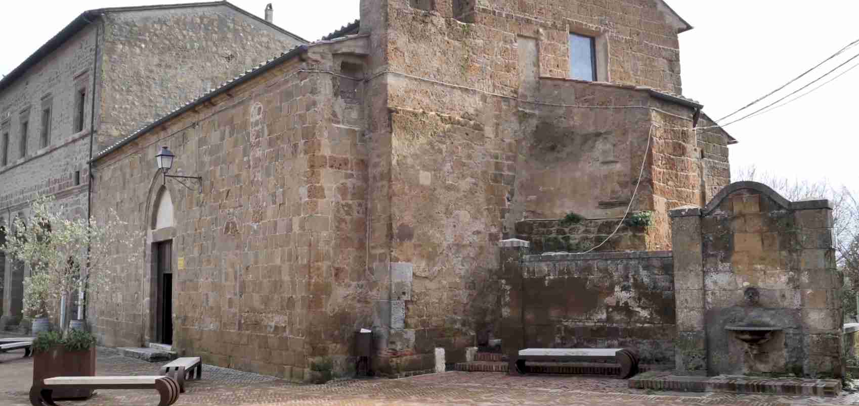
Monastic Solitude in the Tufa Cliffs: The Rupestrian Sanctuaries of Sovana and the Fiora Valley
Along the Fiora River, where Tuscany’s southern edge dissolves into the volcanic uplands of northern Lazio, a chain of rock-cut sanctuaries stands hidden in gorges and tufa cliff faces that medieval hermits and monks chose for their remoteness and their strange, otherworldly beauty. Carved directly into pale volcanic rock — sometimes repurposing Etruscan tomb chambers that had already waited two thousand years — these oratories, hermitages, and monastic cells represent one of Italy’s least-documented traditions of sacred rupestrian architecture, a landscape of prayer that has survived in the forests because it was built into the earth itself.
Key Takeaways
- The Fiora Valley’s rupestrian sanctuaries are carved into the soft volcanic tufa rock that characterizes the southern Tuscan-Lazio borderlands, ranging from small single-nave oratories to multi-room monastic complexes built on several levels within vertical cliff faces.
- The eremitic tradition in this valley began in the early medieval period, when hermits inspired by the Desert Father model withdrew to the Fiora’s remote gorges following the Lombard disruption of established ecclesiastical life in the 6th and 7th centuries.
- The principal sanctuaries include the Oratorio Rupestre di Sovana, the Eremo di Poggio Conte (documented from 1027), the Eremo di Ripatonna Cicognina, and the Complesso Rupestre di Santa Lucia, along with the enormous rupestrian settlement of Vitozza near Sorano — one of the largest in central Italy.
- The Eremo di Poggio Conte preserves a unique fresco program combining apostolic imagery, floral and geometric decoration, and unusual symbolic motifs, which has prompted sustained scholarly debate about an early Templar connection before the Order’s suppression in 1312.
- The Etruscan vie cave — sunken roads cut up to twenty meters deep into tufa — formed a sacred topographic network that Christian communities later adapted for processions, pilgrimage, and the physical linking of cliff-face sanctuaries to Sovana’s Romanesque cathedral.
- Six frescoes stolen from Poggio Conte in 1964 are now preserved at the Museo Civico di Ischia di Castro; the remaining sanctuaries face ongoing structural fragility, limited conservation funding, and access difficulties that make rigorous scholarly documentation challenging.
People Also Ask About the Rupestrian Sanctuaries of Sovana and the Fiora Valley
What are rupestrian sanctuaries and how do they differ from conventional rock-cut churches?
Rupestrian sanctuaries are sacred spaces carved directly into living rock rather than built from quarried stone. The distinction from conventional churches is total: the rock face is simultaneously building material, wall, and roof, with worshippers inside the earth rather than within a structure placed upon it. Unlike the famous rupestrian churches of Matera — inserted into an existing inhabited cave city — the Fiora Valley oratories and hermitages were created in deliberate isolation, their physical remoteness being the spiritual point. They range from simple single-chamber oratories with a carved altar and incised cross to complex multi-level monastic settlements incorporating chapels, sleeping cells, grain stores, water cisterns, and kitchen gardens, all excavated from a single tufa wall. The Italian tradition of rupestrian sacred architecture is ancient and geographically dispersed — concentrated in Basilicata, Puglia, and Calabria but present in scattered clusters across Lazio, Umbria, and the Maremma — and the Fiora Valley represents one of its northernmost expressions.
Why did medieval monks choose the tufa cliffs of the Fiora Valley for their sanctuaries?
Several factors converged to make the Fiora Valley’s tufa cliffs an ideal location for rupestrian monasticism. Tufa is exceptionally soft when freshly exposed or wetted, carveable with hand tools alone; a small community could excavate a livable complex within weeks or months. The valley’s deep gorges offered year-round water from the river and its tributaries, south-facing walls that captured winter sun, and near-total isolation from any road or settlement. The frontier character of the valley — running along the disputed administrative boundary between the Papal States and Tuscan territories — made it a zone where ordinary jurisdictional authority was thin: hermits could live outside both civic and ecclesiastical routine. And the landscape was already saturated with a sacred prehistory: Etruscan hypogea and tomb chambers carved into every hillside offered ready-made vocabulary and sometimes ready-made spaces that early medieval communities could adapt and rededicate to Christian use.
Who were the monks and hermits who carved and inhabited these sanctuaries?
The earliest inhabitants were probably solitary anachoretes — anonymous ascetics who sought cliff faces as the Egyptian desert monks had sought sand, with no community infrastructure beyond a cell, an oratory, and a spring. By the 10th and 11th centuries, loose monastic communities appear: the hermitages along the Fiora’s Lazio bank likely depended on the Benedictine Abbey of San Colombano, documented from the 9th century and now entirely lost except in archive references. Later phases of habitation brought Cistercian-influenced Benedictine monks, and at least one site — the Eremo di Poggio Conte — may have passed through a period of Templar use before the Order’s suppression in 1312. Ripatonna Cicognina remained inhabited until at least 1614, when a date inscribed on an interior wall marks one of its last documented occupants.
Can visitors reach the rupestrian sanctuaries of the Fiora Valley today?
The principal sanctuaries are reachable with moderate physical effort and appropriate footwear. The Oratorio Rupestre di Sovana sits within the Città del Tufo Archaeological Park, near the Via Cava di San Sebastiano on the road from Sovana toward San Martino sul Fiora. Vitozza and the San Rocco rupestrian settlement are accessible on marked footpaths within the same park (inaugurated 1998, covering 60 hectares). The Eremo di Poggio Conte and Eremo di Ripatonna Cicognina require hikeable trails along the Fiora and Olpeta rivers from near Ischia di Castro — routes that local archaeological guides and trekking operators offer as half-day excursions. Structural fragility places some chambers off-limits for safety. Trail-ready footwear and awareness of uneven, sometimes slippery terrain are essential at all sites.
Extended multi-day tours – 5+ days
Featured Tuscany Multi-Day Tour Packages

4 days
The Best of Tuscany: Florence, Chianti & Cinque Terre Escape | 4 Days
- ✓ Comprehensive Tuscany tour
- ✓ Expert local guides included
- ✓ All accommodation arranged
- ✓ Transportation provided
3 days
Taste of Tuscany: A San Gimignano Wine Escape | 3 Days
- ✓ Booking needs min. 2 travelers
7 days
Tuscany to Cinque Terre: Wines, Villages & Unforgettable Walks
- ✓ Comprehensive Tuscany tour
- ✓ Expert local guides included
- ✓ All accommodation arranged
- ✓ Transportation provided
5 days
5 Day Tuscan Food & Wine Tour Package
- ✓ Comprehensive Tuscany tour
- ✓ Expert local guides included
- ✓ All accommodation arranged
- ✓ Transportation provided
Multi-day tour packages powered by TourRadar. Prices and availability subject to change.
The Sacred Landscape of the Fiora Valley: An Introduction
The Fiora River rises on the southern slopes of Monte Amiata and runs southwestward toward the Tyrrhenian Sea, tracing for much of its course the administrative boundary between Tuscany and Lazio. In the Middle Ages, this meant something more visceral: the river marked the frontier between the territories of the Aldobrandeschi — the great Tuscan comital family who controlled Sovana and the surrounding uplands — and the lands subject to the Papal States to the south. Frontier zones in medieval Italy attracted a specific kind of inhabitant: those who wished to be beyond jurisdiction, beyond the reach of diocesan bishops and secular lords, beyond the world itself. The hermits who carved their sanctuaries into the Fiora’s tufa gorges were precisely this kind of inhabitant.
The landscape that drew them is unlike almost anywhere else in Italy. The Fiora Valley’s dominant geological material is tufa — a pale volcanic rock formed from ancient airfall deposits, porous enough to regulate humidity, soft enough to cut with iron tools, hard enough to stand unsupported for millennia. From a distance, the valley walls look like natural cliffs; closer inspection reveals that almost every surface has been worked at some point. Etruscan tomb-cutters began it. Medieval quarrymen continued it. Hermits and monks completed it, turning cliff faces into inhabited architecture by subtraction rather than construction.
The towns that overlook this valley — Pitigliano, Sorano, and Sovana, collectively known as the Città del Tufo — are built from the same material as the rock on which they stand, making the boundary between geology and architecture essentially invisible. Sovana, the smallest and oldest of the three, sits on a narrow ridge between the Fosso di Folonia and the Fosso Calesina, a few kilometers from the Fiora itself. Its medieval cathedral and the Church of San Mamiliano, the traces of Aldobrandeschi fortifications, and the Etruscan necropolises that begin where the last house ends: all of it is tufa, and all of it sits in continuous physical relation with the rupestrian sanctuaries carved into the slopes below. The sanctuaries are not separate from the town’s religious history; they are its underground extension.
What Is Rupestrian Sacred Architecture?
Defining the Rock-Cut Sanctuary
The term “rupestrian” comes from the Latin rupes, meaning cliff or rock face. Rupestrian sacred architecture encompasses any religious structure carved, rather than built, from the natural rock — a category that includes isolated single-chamber oratories, cliff-face hermitages with multiple rooms, rock-cut baptisteries, and entire communities of cave-churches grouped into monastic complexes. What distinguishes rupestrian architecture from the simple use of natural caves is intentionality and shaping: the spaces are planned, their proportions deliberate, their liturgical features — altars, niches, font basins, priests’ seats — carved into place rather than furnished. The rock wall serves simultaneously as structure, insulation, and iconographic surface.
In Italy, the rupestrian tradition is most densely concentrated in the south: the Murgia plateau around Matera (a UNESCO World Heritage Site), the Gravine of Puglia, the valleys of Calabria, and the Byzantine-influenced zones of Basilicata contain hundreds of dated examples. But the tradition extends northward in scattered clusters wherever two conditions are met: appropriate geology (soft limestone, tufa, or sandstone) and the social and spiritual conditions that drove communities into isolation. The Fiora Valley and the southern Tuscan-Lazio borderlands meet both conditions, and the resulting rupestrian heritage — less studied, less visited, less restored than its southern counterparts — is all the more remarkable for its fragmentary survival.
Tufa, Tool, and Time: The Material Conditions of Rupestrian Architecture
The tufa of the Fiora Valley is an ignimbrite, formed when pyroclastic material from ancient volcanic eruptions settled as ash falls and compacted into a cohesive rock. Its mechanical properties made it the material of choice for everything in the landscape: Etruscan tomb-cutters could excavate an entire chamber tomb in days rather than weeks, using iron picks and wooden wedges to detach blocks or simply hollow out the interior. Christian hermits and monks inherited these same tools and the same knowledge of how the rock behaved — where it was soft enough to cut quickly, where it might fracture unpredictably, where a natural cave could be extended rather than excavated from scratch.
A small group of determined workers could carve a basic oratory — a single nave with an altar recess, niches for lamps or votive objects, and steps leading to a higher platform — within a few months of sustained effort. Larger complexes, like the multi-level settlement at Ripatonna Cicognina, required decades of incremental expansion. The resulting spaces have a characteristic quality: slightly irregular in their proportions, responsive to the natural features of the cliff face (following grain lines, accommodating protrusions, avoiding fracture zones), and intimately scaled in a way that constructed architecture rarely achieves. The rock is never entirely mastered; the hermit works with it as much as against it.
A Landscape of Layered Sacrality: Etruscan Hypogea and Christian Sanctuaries
The Etruscan Necropolis as Precondition
To understand the Christian rupestrian sanctuaries of the Fiora Valley, it is necessary to understand what already existed when the first hermits arrived. The hills surrounding Sovana contain one of the most extraordinary concentrations of Etruscan funerary architecture in Italy: more than a hundred monumental tombs cut into the tufa slopes between the 8th and 3rd centuries BCE. The greatest of these — the Tomba Ildebranda, the Tomba della Sirena, the Tomba del Tifone on Poggio Stanziale — represent architectural feats of considerable sophistication, with carved columns, pediments, and interior chambers that replicate in rock the formal vocabulary of Etruscan civic architecture. The Città del Tufo Archaeological Park, established in 1998 across approximately 60 hectares of the Sorano commune’s territory, was created precisely to protect and contextualize this layered heritage.
Less celebrated but equally significant are the hundreds of smaller hypogea — chamber tombs, columbaria, and rock-cut cellars — that honeycomb the valley slopes below the monumental necropolises. These functional voids in the tufa were not abandoned after the Etruscan period; they were reused, continuously, as the economic needs of successive populations dictated. Romans converted them for storage. Late antique communities used them as first shelters. Medieval settlements treated them as foundations, basements, and occasionally as spaces of worship. The rupestrian oratory near Sovana sits adjacent to the archaeological area precisely because the ritual geography of the site was established long before any Christian arrived — the ground was already sacred, the rock already carved, the tradition of underground use already centuries old.
Rededication and Spatial Continuity
The rededication of Etruscan and Roman hypogea to Christian use follows a pattern visible across central Italy. The new occupants did not necessarily seek to efface the pre-existing carvings; in many cases they worked around them, adding a cross to a ceiling that already bore Etruscan architectural decoration, inserting a simple altar into a chamber whose proportions were designed for funeral banquets rather than the liturgy. This spatial continuity was not always theologically deliberate — hermits and monks were primarily interested in shelter and silence — but its cumulative effect was to bind the Christian sacred landscape into the tufa topography in ways that made the two indistinguishable. A via cava that began as an Etruscan processional route to a necropolis became, by the 10th century, the approach road to a hermitage. An Etruscan tomb chamber that had held urns of ash for a thousand years held, by the 12th century, an altar and a lamp niche.
The Oratorio Rupestre di Sovana itself illustrates this layering with unusual clarity. Situated just outside the walls of Sovana along the road that leads toward San Martino sul Fiora, the oratory stands at the edge of the Etruscan necropolis area, in a position that would have been entirely familiar from Etruscan ritual geography — sacred ground outside the inhabited settlement, associated with the dead and with transition. The early medieval community that carved or extended this space was inserting a Christian prayer stop into a landscape whose ritual logic was already established.
The Christianization of Sovana and the Rise of Eremitism
San Mamiliano and the Early Episcopal Tradition
Sovana holds a distinction rare even by Italian standards: it is considered one of the first cities in Tuscany to convert to Christianity. Tradition attributes this to Mamiliano, Bishop of Palermo, who carried out evangelization work in the Sovana area at the beginning of the 4th century. The conversion earned Sovana its appointment as an episcopal see in the 5th century — an early and permanent ecclesiastical status that shaped the town’s role across the following millennium. The relics of San Mamiliano are preserved to this day in the travertine sarcophagus within Sovana’s cathedral; in 2004, during restoration of the small Church of San Mamiliano (which scholars believe may have served as the first diocesan seat before the episcopal function transferred to the cathedral), archaeologists discovered a cache of 498 gold coins dating to the 5th century, a find that gave unexpected material substance to the Mamiliano tradition.
The cathedral itself — the Co-Cathedral of Saints Peter and Paul, a co-cathedral within the Diocese of Pitigliano-Sovana-Orbetello since 1986 — was documented in a bull by Pope Nicholas II in 1061, though the founding church on the site is attributed to the 8th-9th centuries. The present Romanesque structure was largely rebuilt in 1248 and represents a mixture of Lombard and Gothic elements that reflects the complexity of Sovana’s political history. The Church of Santa Maria, with its elegant 9th-century ciborium, is likely one of the oldest surviving built structures in the town. This early and dense ecclesiastical character makes Sovana something unusual in the rupestrian landscape: most of Italy’s great rock-sanctuary zones are places where the institutional church was absent or weak, and solitary hermits filled the spiritual vacuum. In the Fiora Valley, the opposite is true — rupestrian monasticism developed in the shadow of one of the region’s most ancient dioceses, in complicated relationship with established ecclesiastical authority rather than as a replacement for it.
Lombard Disruption and the Desert-Father Impulse
The Lombard conquest of much of central Italy between 529 and 605 CE fractured the institutional church’s grip on the landscape. Established monasteries were sacked, diocesan administration became intermittent, and the routes of pastoral care that had linked towns to their dependent rural communities were interrupted. In this disruption lay the spiritual opportunity that the eremitic movement seized. Hermits who withdrew to cliff faces and gorges were not simply avoiding the world for private spiritual reasons; they were, in many cases, the primary religious practitioners available to isolated rural communities that could no longer depend on regular priestly visits.
The Desert Father tradition — the movement founded by figures like Anthony the Abbot and Paul of Thebes in 3rd- and 4th-century Egypt, which taught that the highest form of Christian life was solitary withdrawal from society in a barren or isolated landscape — provided the theological language for this withdrawal. Sant’Antonio Abate, the model hermit, is explicitly invoked in the fresco tradition of at least one of the Fiora Valley hermitages: the Eremo di Ripatonna Cicognina was probably dedicated to this saint, and its frescoes depict him with the distinctive iconographic attributes — the small bell in the left hand and the T-shaped staff in the right — that identify him across centuries of Italian devotional imagery. The hermits of the Fiora Valley were not provincial innovators; they were participants in a tradition that stretched from Egypt to Ireland, and their geography expressed their theology.
The Principal Rupestrian Sanctuaries of Sovana and the Fiora Valley
The Oratorio Rupestre di Sovana
The rupestrian oratory near Sovana sits along the provincial road that links the village to San Martino sul Fiora, just beyond the road tunnel at the edge of the Etruscan necropolis area. It presents itself to the walker as a ruin rather than an intact sanctuary: its ceiling is partially collapsed, and the approaches are overgrown. What survives is nonetheless legible as sacred space. The oratory takes the form of a single nave carved entirely into the tufa cliff face, its proportions modest — a space for individual prayer or for very small congregations rather than for formal liturgy. The ceiling’s defining feature is a large cross executed by the technique of rupestrian incision: cut directly into the rock surface rather than painted, it constitutes the primary sacred marker of the space and makes the oratory’s religious function unmistakable even in its ruined state.
The origins of the oratory are genuinely uncertain, a rarity among sites that can be at least approximately dated from architectural and archaeological evidence. The most plausible scholarly interpretation places it in the early medieval period, likely between the 7th and 10th centuries, at or near a location that had already served Etrusco-Roman religious functions — the proximity to the necropolis suggests that the sacred topography of this cliff edge was established long before any Christian carved a cross into it. In the centuries after its construction, the oratory probably served as a waystation for travelers crossing between the Fiora’s two banks, a prayer stop along a route where the river crossing made religious propitiation feel appropriate. It was not a hermitage in the strict sense — there is no evidence of permanent habitation — but a node in a devotional network whose other points included the cathedral in Sovana and the more substantial sanctuaries further along the valley.
The Second Oratory Complex Outside Sovana
A second rupestrian complex survives in the scrubland near Sovana, less visited and harder to locate than the roadside oratory. This site articulates across several interconnected rooms carved into a tufa wall: some are inaccessible due to structural collapse, but the main aula remains legible. Its liturgical grammar is intact: a stepped altar carved directly from the rock in the apse position, with the steps themselves incised into the floor, flanked by wall niches that would have held lamps or votive objects. A large cross is carved into the ceiling, reinforcing the oratory’s identification as Christian sacred space. On the walls of an adjacent chamber, fresco fragments survive — traces of three figures identified by some researchers as saints, their iconography too damaged for certain attribution but sufficient to confirm the space was once decorated in the pictorial tradition of medieval Italian ecclesiastical art.
A controversial inscription on the right wall has prompted suggestions of an extremely early date — the 4th century — but this reading is not supported by other indicators in the space, and most scholars treat the complex as early medieval rather than late antique in its current form. The presence of two connected oratories so close to Sovana, both positioned along routes linking the town to the Fiora crossing at San Martino sul Fiora, suggests a structured devotional landscape: the rock-cut sanctuaries were not isolated accidents but planned points in a pilgrimage or processional geography organized around the cathedral at Sovana’s center and extending outward into the agricultural and pastoral landscape beyond the walls.
The Rupestrian Settlement of Vitozza
Vitozza is the most physically dramatic of the rupestrian sites in the broader Sovana area — a complete medieval settlement carved into and onto a tufa spur above the valley between Sorano and San Quirico, one of the largest rupestrian centers in central Italy and second in scale only to the Sassi di Matera. Its more than 200 caves, cut into the tufa hillside over centuries of continuous use, were organized into a functioning community: cave dwellings for residential use (concentrated on the more sheltered, sun-exposed southwestern slope), cave stables and warehouses, cisterns for collecting rainwater, wells for waste, and elaborate niches and shelving cut into walls for the storage of domestic goods. Vitozza reached its greatest development between the 13th and 14th centuries, when the construction of walls, towers, fortifications, and its small fortress gave it the infrastructure of a proper medieval town. It was finally abandoned in the 18th century, when the Lorena government conducting a census of the area found it still sparsely inhabited.
The religious dimension of Vitozza is expressed in three churches that formed part of the settlement, the only structures in the complex built with elevation — with walls and roofs constructed above rather than carved below. This architectural distinction between the sacred and the secular, between built and carved, is repeated across the rupestrian tradition: the church stands up while the dwelling digs down. The churches are now largely ruined, but their positions within the settlement — distributed to serve the different inhabited slopes — reflect a considered pastoral geography. Vitozza belongs to the broader category of rupestrian settlements rather than specifically to sacred rupestrian architecture, but its integration of lived domestic space and religious provision makes it an essential part of understanding how the cliff-face life was organized across the Fiora Valley landscape.
The Insediamento Rupestre di San Rocco
The rupestrian settlement of San Rocco, located approximately two kilometers from Sorano along the road toward Sovana, takes its name from an 18th-century church that is not itself part of the ancient complex. The site itself is significantly older: it preserves Etruscan chamber tombs, Roman-era columbaria, and medieval cave dwellings alongside an early medieval furnace — evidence of continuous industrial and domestic use across fifteen centuries. The columbaria (originally interpreted as Roman funerary monuments but now identified by archaeologists as medieval pigeon coops and dovecotes) dot the cliff faces in and around San Rocco in remarkable numbers, reflecting the economic dependence of medieval communities on pigeon meat and pigeon dung as fertilizer — a material history written into the rock face alongside the sacred. From San Rocco, the Via Cava di San Rocco — approximately six kilometers of Etruscan-cut sunken road — connects through the valley of the Lente River to Vitozza, forming one of the most atmospheric routes in the Città del Tufo landscape. The settlement is part of the official Archaeological Park and is accessible on marked footpaths from the car park near the Sorano-Sovana road.
The Eremo di Poggio Conte
The Eremo di Poggio Conte is the most architecturally and iconographically rich of the Fiora Valley sanctuaries — and the most debated. Located in the commune of Ischia di Castro in the Province of Viterbo (Lazio), approximately twenty kilometers along the SP109 from the town, it sits on the Lazio bank of the Fiora in territory that in the Middle Ages lay within the disputed frontier between the Papal States and Tuscany. The site is documented from 1027 and is also known as the Eremo di San Colombano, the patron of the Benedictine abbey to which it probably once belonged.
The approach to Poggio Conte prepares the visitor for an experience outside ordinary categories. A trail follows the Fiora downstream, passes through riparian forest, then enters a gorge via a sequence of wooden steps cut into the slope. The gorge terminates at a natural amphitheater where a small waterfall drops from the tufa overhang above, and it is in the upper cliff of this amphitheater, high enough to require a scramble, that the hermitage is carved. Access to the church is through a portal surmounted by a circular opening — a rosette or bull’s-eye aperture — cut through the rock above the doorway. This aperture serves a function beyond light and ventilation: during the autumn equinox, a ray of sunlight passes through it and falls precisely into the thirteenth and deepest of the niches carved near the ceiling of the entrance room. This niche held the image of Christ; the twelve flanking niches held the apostles. The alignment of the equinox light with the central figure is either an extraordinary coincidence or — more plausibly, given what else is known about the site — evidence of deliberate astronomical orientation by its builders.
The church is carved as two frescoed rooms with tufa pilasters, columns, and carved capitals supporting the ceiling. A tufa altar and a bishop’s throne (cattedra vescovile) carved from the rock stand in the principal room. The fresco program that covered the walls was executed in red, ochre, black, and deep blue — colors of rare quality and unusual brilliance for a remote hermitage — and depicts a striking combination of motifs: apostolic figures in their niches, the image of Christ, floral and geometric interlacings, and designs that scholars have described as erotic or sexual in character, deeply unusual in any context of Christian sacred decoration. An inverted triangle is incised on the capital of the left column and repeated on the exterior of the hermit’s residential chamber adjacent to the church. In 1964, six of the frescoes were removed from the site by thieves; the surviving panels are now held at the Museo Civico di Ischia di Castro. The remaining wall paintings are fragile and partially deteriorated but still convey the original program’s visual intensity.
The Eremo di Ripatonna Cicognina
Ripatonna Cicognina — also known as Chiusa del Vescovo, a name that suggests a bishop may at some point have been held or have retreated here — occupies a position on the Fiora Valley’s Lazio bank that differs from Poggio Conte in almost every architectural quality. Where Poggio Conte is compact and focused, Ripatonna is extensive and labyrinthine: a complex carved across multiple levels into a tufa wall overlooking the Olpeta River a few hundred meters upstream from its confluence with the Fiora. It is the largest of the area’s hermitages, and one scholar has plausibly described it as assimilable to a small monastery rather than a single hermit’s cell.
The site is reached via a trail from near Ischia di Castro, ascending a short but steep path to the rock face where the hermitage’s various entrances open. The internal organization is complex: a church with a barrel-vaulted ceiling and traceable fresco remains, a grain-storage room with a floor well, chambers that served as storerooms with identifiable niches and carved shelving, a corridor leading to a narrow residential cell with a window opening onto the forest and valley below. The frescoes in the church, attributed to the Sienese school of the 15th century, depict Sant’Antonio Abate with his traditional attributes and a bishop saint whose identification has not been firmly established. A date of 1614 is inscribed on one interior wall, confirming use into the early 17th century. A documentary source from 1630 — a report to the Duke of Castro by one Benedetto Zucchi — describes the site as a “romitorio called Ripatonna Cicognina, set on the bank of the Olpeta, on the tufa of that bank, not far from Castro, a place of beautiful view, with a fountain and garden space appropriate to such a purpose, with a consecrated church inside where Mass can be said and other good amenities: though on account of bad air it is not too inhabited.” This is the period of its final, intermittent use before abandonment.
The name Ripatonna Cicognina may derive from the rounded form (“tonna”) of the river’s banks (“ripe”) or from the presence of stork nests (“cicogne”) in the cliffs — either etymology placing the site within the biological and geomorphological realities of its gorge setting rather than giving it a saint’s name or a lord’s name. This is characteristic of the minor rupestrian sites: they are named after what they look like or where they stand, not after whom they were dedicated to, and the landscape writes itself into their identity.
The Complesso Rupestre di Santa Lucia
The third of the principal rupestrian sanctuaries on the Fiora Valley’s Lazio bank, the Complesso Rupestre di Santa Lucia, is the least documented and least visited of the group. It sits in the same gorge landscape as Poggio Conte and Ripatonna Cicognina, accessible via trails that follow the Fiora through oak forest and across sections of travertine and tufa erosion. The complex is dedicated to Santa Lucia, whose martyrdom and association with light make her a particularly fitting patron for a space that, like all these sanctuaries, depends on controlling and directing the limited light that penetrates the cliff face. The structural condition of the Santa Lucia complex is more fragile than either of its companions, with partial collapse restricting access to some chambers, but the site forms an essential part of the devotional geography of the middle Fiora: the three hermitages together constituted a landscape of prayer strung along the river like beads on a cord, each within a day’s walking distance of the others, collectively served (in all probability) by the same monastic network that the Abbey of San Colombano organized.
Architectural Language of the Rock-Cut Sanctuary
Carved Space and Its Liturgical Grammar
Despite their apparent individuality, the rupestrian sanctuaries of the Fiora Valley share a coherent architectural vocabulary derived from the requirements of Christian liturgy as practiced by small monastic communities between the 9th and 15th centuries. The organizing principle is the distinction between the space of the priest and the space of the congregation, expressed in a carved architecture that replicates in miniature the tripartite organization of the conventional basilica: a nave-equivalent chamber for the assembled community, a chancel area raised by carved steps, and an apse-equivalent recess where the altar stands against the rock face. This scheme is visible in both Sovana oratories, in the Poggio Conte church, and in the Ripatonna church, each at a different scale and with different degrees of elaboration.
The altar is always a single block of tufa, carved in place: it cannot be moved, cannot be replaced, and cannot be separated from the wall behind it. Wall niches flanking the altar — carved into the tufa at heights corresponding to the liturgical functions of lamps, reliquaries, and consecrated vessels — are present in every sanctuary. The bishop’s throne or cattedra at Poggio Conte, carved from the living rock at the south side of the chancel, confirms that the site served, at some point, a presiding ecclesiastical function beyond that of a simple hermit’s chapel — whether for an actual bishop in residence or as a symbolic expression of apostolic authority is a question the archaeology cannot decisively answer.
Ceiling crosses, incised with a metal tool directly into the tufa, appear in both Sovana oratories and in other sanctuaries of the type. They serve a dual function: as sacred emblems marking the space as explicitly Christian, and as structural markers that allowed the carver to orient the space correctly within the rock. The technical challenge of cutting a rectangular room into an irregular cliff face — maintaining parallel walls, level floors, and a ceiling that neither slopes awkwardly nor encroaches on structural stability — was solved in part by working from reference points inscribed on the ceiling before the main excavation began.
The Fresco Program: Reading the Walls
The painted decoration of rupestrian sanctuaries follows a strict hierarchy that mirrors, in compressed form, the full iconographic programs of contemporary Romanesque and Gothic churches. At its most elaborate — as in the Poggio Conte church — the scheme places Christ at the hierarchical summit (in the deepest and highest niche, oriented toward the east or the point of equinoctial illumination), surrounded by the apostles in their twelve niches, with hagiographic scenes and devotional imagery occupying the lower register of the walls. Geometric and vegetal interlacings serve as border ornament, the vocabulary of which is shared across 12th- and 13th-century decorative schemes from Campania to Lombardy.
What distinguishes the Poggio Conte frescoes from any comparable program in the region is the presence of explicitly non-Christian imagery: the geometric and floral motifs are conventional enough, but the erotic and symbolic figures — the inverted triangle, the designs that scholars have associated with Templar or esoteric traditions — sit alongside the apostles in a combination without parallel in the standard rupestrian repertoire. The Sienese-school frescoes at Ripatonna Cicognina, attributable to the 15th century, are more orthodox: Sant’Antonio Abate and a bishop saint follow a familiar late-medieval pictorial convention. The contrast between the two sites’ fresco traditions reflects the different communities and different chronological phases of their occupations, and it cautions against treating the valley’s hermitages as a homogeneous tradition — each sanctuary has its own theological character, expressed in paint.
The Templar Question: Evidence and Scholarly Hypothesis
The Iconographic Puzzle at Poggio Conte
The Knights Templar — the religious-military order founded in Jerusalem in 1119 and suppressed by papal decree in 1312 — have attracted popular and scholarly attention at Poggio Conte since the site’s modern rediscovery, and the connection deserves careful treatment. The evidence for Templar involvement is circumstantial but not negligible. The inverted triangle carved on the column capital is a symbol associated with Templar geometry; the equinoctial solar alignment through the portal aperture reflects a precision of astronomical observation that Templar builders practiced at other sites across Europe. The unusual erotic and esoteric imagery is difficult to explain within mainstream Benedictine devotional programs but has parallels in sites associated with the Order in the Languedoc and central Italy. And the location — on a frontier between jurisdictions, in a zone the Templars were known to control by virtue of their stewardship of the ancient Via Clodia — is consistent with Templar property patterns elsewhere.
The most plausible scholarly reconstruction treats Poggio Conte as having had at least two distinct occupational phases: an earlier phase, from its documented date of 1027 through the 12th century, in which the site may have been associated with or constructed by the Templar Order; and a later phase, following the Order’s suppression in 1312, when Benedictine-Cistercian monks inherited the site, modified the vault, and overlaid the earlier iconographic program with more orthodox Christian imagery. The Gothic-Cistercian architectural inspiration visible in the church’s proportions and structural details — unusual in a rupestrian context — supports the idea of Cistercian reworking of an earlier space. This reading is a hypothesis, not a certainty; the archive documentation that would confirm it has not been found, and some scholars treat the Templar connection as legend rather than history. What the iconographic evidence makes clear is that Poggio Conte’s history is not simple.
The Abbey of San Colombano and the Monastic Network
The Benedictine Abbey of San Colombano — dedicated to the Irish monk Columbanus (c. 543–615) who founded monasteries across Burgundy and northern Italy — was already documented in the 9th century in the Ischia di Castro area, although its exact location is now lost. This abbey is almost certainly the institutional anchor for the network of rupestrian hermitages along the Fiora’s Lazio bank: Poggio Conte is also known as the Eremo di San Colombano, and the hermitages of the area are best understood as dependent establishments — places where individual monks or small groups could practice a more intense eremitic life while remaining formally attached to the abbey’s authority and pastoral care. The Cistercian reform of the 12th century, which emphasized both physical labor and the colonization of wilderness landscapes, may have been responsible for the more architecturally refined phase of Poggio Conte’s development, including the fresco program that gave the church its current appearance.
The frontier position of the valley — between Papal and Tuscan territories, between the dioceses of Sovana (Tuscany) and Acquapendente (Lazio) — made it a liminal space that monastic communities could occupy with relative institutional independence. The hermitages were not under the continuous supervision of either bishop. This freedom from diocesan oversight was not unusual in the wider Benedictine tradition, which had developed complex legal mechanisms for exemption from local episcopal authority, but it was particularly pronounced in border zones like the Fiora, where the uncertain jurisdictional map gave monastic communities room to develop their own practices and devotional cultures.
The Vie Cave as Sacred Network
Etruscan Origins and the Topography of the Hollow Way
The vie cave — literally “hollow ways” or “sunken roads” — are among the most extraordinary landscape features of the Fiora Valley. Cut by Etruscan workers through the tufa plateaus and slopes between the valley’s settlements and necropolises, they are in essence open-air corridors: up to three meters wide and up to twenty meters deep, their walls rising sheer on both sides, their floors worn smooth by millennia of foot and animal traffic. The vie cave served multiple functions for the Etruscans: they connected inhabited centers to watercourses and to necropolises, they provided defensive advantages (an enemy descending into a via cava was at a severe tactical disadvantage against defenders on the rims), and they may have served ritual purposes in the transit of the dead from town to tomb. The most important of the Sovana-area vie cave — the Cavone, the Via Cava di San Sebastiano, the Via Cava di Poggio Prisca, the Via Cava di San Rocco — are all dateable to the 7th-6th centuries BCE from the archaic tombs cut along their routes.
The Via Cava di San Sebastiano deserves particular attention in the context of the rupestrian sanctuaries. Its route runs from the Sovana necropolis through the tufa plateau toward the Fiora Valley, passing the location of the Oratorio Rupestre where a landslide now blocks the original path. The information panel at the blockage specifically identifies the rupestrian oratory as a feature of the original via cava route — a waystation carved at the point where the path began its descent toward the river. This confirms that the oratory’s location was not arbitrary but integrated into the ancient road network, the Christian sacred space inserted into an Etruscan topographic logic that was already more than a millennium old when the first hermit cut a cross into the ceiling.
Procession, Pilgrimage, and the Walk Between Worlds
In medieval use, the vie cave acquired new ceremonial functions that layered Christian processions over Etruscan funerary routes. The visual experience of walking a via cava — entering the tufa corridor, losing sight of the sky as the walls rise overhead, the temperature dropping, the acoustic environment becoming intimate and enclosed — is powerful even for a secular walker. For a medieval community processing from Sovana’s cathedral to a cliff-face oratory on a feast day, the via cava would have served as a transitional space: a passage from the inhabited, structured world of the town into the wild and sacred space of the cliffs. The rupestrian sanctuaries at the terminus of these routes were, in this reading, not simply private hermitages but communal destinations, approached through a landscape that prepared the pilgrim for encounter with the divine by progressively narrowing and deepening the route until the cliff face itself became the destination.
This understanding of the vie cave as processional infrastructure changes the interpretive frame for the rupestrian oratories. They were not purely the domain of solitary monks, sealed off from lay community life; they were visited, tended, and approached by the population of the surrounding towns, and their architectural provisions — even a simple oratory with no residential cells — make sense only within a devotional geography that assumed regular lay attendance. The hermit in the cliff was a point of spiritual reference for the valley community, and the sunken road was the means by which that reference was accessed.
Monastic Life in the Tufa Cliffs
Water, Garden, and the Material Conditions of Isolation
Every rupestrian hermitage in the Fiora Valley is located near a perennial water source, and this is not a coincidence: the selection of a cliff face for permanent habitation required water within easy walking or climbing distance, both for drinking and for the kitchen garden that all the sites preserved traces of. At Ripatonna Cicognina, Benedetto Zucchi’s 1630 description explicitly notes the fountain fed by a spring at the base of the cliff and the “garden space appropriate to such a purpose.” At Poggio Conte, the waterfall that cascades into the natural amphitheater below the hermitage would have provided both water and a visual symbol of spiritual cleansing appropriate to the site’s monastic function. At Vitozza, the cisterns carved into the cave floors and the multiple wells visible in domestic caves attest to the sophistication with which water management was integrated into the rupestrian design.
The grain well at Ripatonna — a pit cut into the floor of one room for the long-term storage of dried grain — illustrates the practical economics of cliff-face life. A monk or hermit who needed to survive months of winter in a rock-cut cell required not simply spiritual resources but logistical ones: stored food, protection from rain and cold (the tufa, paradoxically, provides good thermal insulation), and the means to care for any crops or small livestock that supplemented the garden. The single small residential chamber at Ripatonna Cicognina — the one room with a window, with a bed, with the scale of a single person’s domestic world — gives a vivid sense of what the ideal of monastic solitude looked like in material terms: not imprisonment, but studied simplicity, the minimum of possessions sufficient to sustain a life concentrated on prayer.
The Duration of Habitation and the Experience of Time
The rupestrian sanctuaries of the Fiora Valley were not flash-in-the-pan spiritual experiments. Poggio Conte was in use from at least 1027 — a date that places it well into the mature medieval period — and the complexity of its fresco program suggests sustained occupational investment over decades or centuries. Ripatonna Cicognina’s dateable fresco traces go from the 15th century through to at least 1614 — a use-life of well over a century for what appears to have been the building’s latest occupational phase, and perhaps much longer for the excavated complex as a whole. Even the more modest Sovana oratories, which show no evidence of permanent habitation, maintained their sacred functions as prayer stops and devotional waypoints from their early medieval founding through to the abandonment of the valley’s eremitic tradition in the early modern period.
This longevity shapes how the sanctuaries should be understood. They are not ruins in the conventional sense — structures that were built, used briefly, and then abandoned in a single phase. They are palimpsests, accumulations of use from multiple periods each of which left its mark: a niche cut here, a fresco added there, a wall shored up with masonry where the tufa began to fracture. The inscribed date of 1614 at Ripatonna is both a precise historical marker and a symptom of a process that had been going on for at least six centuries: a community of people using rock-cut space, adapting it to changing needs, leaving evidence of their presence carved or painted into the stone, and then departing.
Conservation Challenges and Scholarly Attention
The 1964 Theft and the Museo Civico di Ischia di Castro
The most dramatic episode in the recent conservation history of the Fiora Valley sanctuaries occurred in 1964, when six fresco panels were removed from the Eremo di Poggio Conte by thieves. The theft was part of a broader wave of illegal excavation and art removal that afflicted central Italian archaeological sites throughout the 1960s, a period when weak protective legislation and strong international demand for antiquities created catastrophic losses across the region. The removed frescoes from Poggio Conte — depicting apostolic figures and other elements of the original program — were eventually recovered and are now displayed at the Museo Civico di Ischia di Castro in the Province of Viterbo. This means that understanding the complete iconographic program of Poggio Conte now requires visits to two separate locations: the hermitage itself for the remaining painted surfaces and the architectural context, and the museum for the removed panels. The 1964 event also accelerated the existing deterioration of the remaining frescoes: exposure to atmosphere following the removal of adjacent painted sections, and the disturbance of the friable tufa surface during extraction, have left visible damage.
Structural Fragility and Access
Beyond the 1964 theft, the primary conservation challenge facing all the Fiora Valley sanctuaries is the inherent fragility of rupestrian architecture in an uncontrolled environment. Tufa is soft enough to carve easily, which also means it is soft enough to erode progressively under rain, frost, and root penetration. Several chambers at the second Sovana oratory complex are closed to visitors due to ceiling collapse risk. The pigeon-coop columbaria at Vitozza and San Rocco are partially supported by steel joists. At Ripatonna Cicognina, the 2022 description by the Terraincognita.earth guide notes that “the ground tends to crumble and the vaults, like the perimeter walls, present a considerable state of abandonment.” The site is not dangerous to the careful visitor, but it is visibly deteriorating.
The rupestrian sanctuaries of the Fiora Valley have attracted scholarly attention from researchers working in the intersection of medieval history, archaeology of religion, and rupestrian studies. The foundational scholarly reference for the Lazio-bank hermitages is Joselita Raspi Serra’s 1976 Insediamenti rupestri e religiosi della Tuscia, which placed the Fiora Valley sites within the broader Tuscia rupestrian tradition; Giovanni Feo’s Eremiti e romitori di Maremma (Laurum, 2001) added the Maremma dimension. The Città del Tufo Archaeological Park’s own documentation, accessible through the Musei di Maremma system, covers the Sovana area sites. The challenge for future scholarship is the integration of these geographically separate documentary traditions — Tuscany-facing and Lazio-facing — into a unified account of the valley as a single cultural landscape, which its medieval inhabitants clearly understood it to be.
How to Explore the Rupestrian Sanctuaries of the Fiora Valley
Visiting the Oratorio Rupestre and the Città del Tufo Archaeological Park
The Città del Tufo Archaeological Park is the logical base for exploring the Sovana-area rupestrian sites. The park’s three sectors — the Etruscan necropolis of Sovana, the San Rocco rupestrian settlement near Sorano, and the Vitozza rupestrian settlement in the San Quirico fraction — are connected by marked footpaths and supported by documentation centers at Sovana (adjacent to the archaeological museum in the Church of San Mamiliano), at the San Rocco entrance, and at the medieval and Renaissance museum in the Orsini Fortress at Sorano. The park covers approximately 60 hectares and has been administered within the provincial Musei di Maremma system since 2004. Vitozza is reachable on foot from San Quirico in about fifteen minutes; the full necropolis circuit at Sovana takes approximately 45 minutes to an hour. The Oratorio Rupestre di Sovana sits just outside the necropolis area along the road to San Martino sul Fiora, and although it lies outside the formal park boundaries, it is unmissable on any visit to the archaeological area.
The rupestrian settlement of San Rocco rewards a separate visit. Its cluster of Etruscan tombs, Roman columbaria, medieval cave dwellings, and the early medieval furnace are condensed into a compact and walk-through site, and the Via Cava di San Rocco — beginning just beyond the settlement — offers one of the most physically immersive experiences in the entire Città del Tufo landscape. The walk along the full six-kilometer via cava to Vitozza takes approximately two to three hours one way and passes through terrain that alternates between deep tufa corridor, open riverside forest, and valley viewpoints. Appropriate footwear and navigation awareness are essential; the route crosses small fords of the Lente River that may be challenging after heavy rain.
The Fiora Valley Trail to Poggio Conte and Ripatonna
The hermitages of Poggio Conte and Ripatonna Cicognina are reached from the Ischia di Castro area in the Province of Viterbo, approximately 20 kilometers from the town along the SP109. The trail to Poggio Conte follows the Fiora downstream through riparian oak forest, crosses a rural wooden bridge, and ascends via wooden steps into the gorge where the hermitage is carved. The total walking time from the roadside parking area is approximately 45 minutes to an hour each way; the trail is described as non-demanding in terms of gradient but requires attention to uneven surfaces. The route to Ripatonna Cicognina begins near the confluence of the Olpeta and Fiora rivers, following the Olpeta upstream for approximately 800 meters on a level path before ascending to the cliff face. Both routes are offered as guided tours by operators in the area — an approach that is strongly recommended for first-time visitors, as the sites’ interpretive signage is limited and the contextual depth provided by an archaeologist or specialist guide substantially enhances the experience. Local operators including LoveMaremma and Percorsi Etruschi offer half-day and full-day combinations of the two hermitages, sometimes extended to include Vitozza and Sovana on the Tuscan bank.
The Sacred Itinerary: Connecting the Valley’s Two Banks
The most richly contextual way to experience the Fiora Valley’s rupestrian heritage is to treat it as a single landscape crossing administrative boundaries, following the logic that its medieval communities would have recognized. A multi-day itinerary that begins at Sovana’s medieval cathedral — with its 9th-century foundations, 12th-century sculptures, and the relics of San Mamiliano that anchor the valley’s Christianization narrative — proceeds through the Etruscan necropolis and the rupestrian oratory, follows a via cava through the tufa plateau, crosses into the Lazio bank to visit Poggio Conte and Ripatonna, and returns along the Fiora to Sorano’s fortress and the San Rocco settlement, captures the full civilizational depth of a landscape where the sacred has been expressed in rock for more than 2,500 years. No other itinerary of comparable length in central Italy offers quite this concentration of rupestrian tradition, Etruscan archaeology, medieval ecclesiastical history, and wild valley landscape in a single continuous experience.
Frequently Asked Questions
What does “rupestrian” mean, and why is the term used for these sites?
The word derives from the Latin rupes, meaning “rock” or “cliff.” In Italian architectural and archaeological usage, “rupestre” or “rupestrian” describes any structure that is carved from living rock rather than built with quarried or fabricated materials. The term is used for the Fiora Valley sanctuaries because their defining characteristic is exactly this: they are not buildings placed against the cliff but spaces created within it, their walls, floors, ceilings, and liturgical furniture all cut from the same continuous mass of tufa. This distinguishes them from cave churches that simply insert an altar into a natural cavern and from cliff-face monasteries that add a constructed facade to a rock-cut interior.
Is there a connection between the Fiora Valley rupestrian sites and the famous Sassi di Matera?
Both belong to the broader Italian rupestrian tradition that flourished in regions with appropriate soft-rock geology, but they represent very different scales and social contexts. The Sassi di Matera is a complete urban settlement — a city of cave dwellings, churches, and public spaces that was continuously inhabited into the 20th century and is now a UNESCO World Heritage Site. The Fiora Valley sites are comparatively modest: isolated hermitages, small oratories, and the abandoned settlement of Vitozza (which, with over 200 caves, is the most Matera-like site in the valley and is indeed considered the most significant rupestrian center in central Italy after Matera). The monastic impulse driving the Fiora Valley sites — withdrawal, solitude, the search for a landscape that would enforce spiritual poverty — is distinct from the urban rupestrian tradition of Matera, where cave-dwelling was a civic norm rather than an ascetic choice.
How did hermits in the Fiora Valley access food and water?
The hermitages are all positioned near perennial water: the river itself, tributary streams, or springs emerging from the base of the tufa cliff. Every known site preserves evidence of a kitchen garden — a cultivated plot at the cliff base or on a nearby accessible terrace where vegetables and herbs could be grown. Grain was stored in floor wells carved into interior rooms, as at Ripatonna Cicognina. Small fruit trees and the vines and olives that naturalized in the valley landscape supplemented the diet. Occasional charity from nearby communities — documented in the relationship between hermitages and the towns they were spiritually associated with — would have provided oil, salt, and other goods that the cliff-face garden could not supply. The material poverty of the eremitic life was genuine but not absolute; what the hermits renounced was surplus, not subsistence.
What role did the Diocese of Sovana play in the rupestrian tradition?
Sovana was one of the oldest episcopal sees in Tuscany, established in the 5th century following the evangelization attributed to San Mamiliano. Its bishops exercised theoretical authority over the spiritual life of the surrounding countryside, including the cliff-face hermitages. In practice, the frontier position of the valley, the jurisdictional ambiguity of the Lazio-bank sites (which fell under the Diocese of Acquapendente rather than Sovana), and the Benedictine hermitages’ claims to exemption from local episcopal authority meant that the relationship between the cathedral and the rupestrian sanctuaries was complex. Pope Gregory VII — Hildebrand of Sovana, born in the town around 1028 — was himself a product of Sovana’s ecclesiastical culture, and his reform program of the late 11th century, which sought to strengthen papal authority over monastic life, would have had direct implications for the hermitages of the valley he grew up beside.
What is the significance of the equinox alignment at the Eremo di Poggio Conte?
At the autumn equinox, a shaft of light enters the Eremo di Poggio Conte through the circular aperture above the portal and illuminates the thirteenth and deepest of the niches carved near the ceiling — the niche reserved for the image of Christ, flanked by the twelve apostles in their surrounding niches. This alignment means that the architecture participates actively in the liturgical calendar, marking the equinox as a significant moment by making visible a light that is invisible on every other day. This kind of solar orientation — common in Romanesque and Gothic church architecture but rare in the cramped proportions of a rupestrian hermitage — implies precise astronomical knowledge on the part of the builders and deliberate orientation of the portal to capture the equinoctial sunrise direction. It is one of the pieces of evidence cited in support of the Templar attribution, given the Order’s documented interest in astronomical alignments at their other sites across Europe.
Why are the frescoes at Poggio Conte considered iconographically unusual?
The Poggio Conte fresco program combines apostolic Christian imagery with geometric, floral, and decorative motifs that include designs scholars have described as erotic or sexually explicit, deeply unusual in any context of Christian sacred art. The combination sits alongside an inverted triangle carved on a column capital — a symbol associated in Templar iconography with the number three — and the equinoctial solar alignment discussed above. This suite of features has no precise parallel in the standard corpus of Italian rupestrian frescoes, which overwhelmingly follows orthodox hagiographic programs. The standard scholarly interpretation treats the unusual imagery as evidence of a pre-Cistercian occupational phase associated with the Templars, overlaid by more orthodox Christian iconography after the Order’s suppression in 1312. The 1964 theft of six panels means that the full program is no longer visible in situ, complicating definitive analysis.
What is the relationship between the vie cave and the rupestrian sanctuaries?
The vie cave are Etruscan-cut sunken roads connecting settlements, necropolises, and watercourses across the tufa plateau landscape. Several of them lead directly to or past rupestrian sacred sites: the Via Cava di San Sebastiano passes the Oratorio Rupestre di Sovana (now blocked by a landslide at the oratory’s location); the Via Cava di San Rocco connects the San Rocco rupestrian settlement to Vitozza over approximately six kilometers through the valley of the Lente River. In the medieval period, these pre-existing routes were adapted for Christian processional and pilgrimage use, with the rupestrian oratories at their termini serving as devotional destinations. The experience of walking a via cava — enclosed by tufa walls rising ten to twenty meters on both sides, sheltered from sun and wind, acoustically intimate — functions as a transitional spatial experience that medieval devotional practice would have recognized as appropriate preparation for arrival at a sacred site.
How large was the community at Vitozza at its peak?
Vitozza reached its greatest extent and population between the 13th and 14th centuries. With over 200 cave chambers organized into residential, agricultural, and civic functions across a tufa spur above the valley, and with the infrastructure of walls, towers, a fortress, and three churches that characterizes a functioning medieval settlement, it supported a substantial community — certainly in the hundreds and possibly more, depending on the density of cave occupation and the extent of the surrounding agricultural territory associated with the settlement. When the Lorena government conducted a census in the 18th century, the settlement had contracted to a small residual population living in conditions that struck the enumerators as marginal; complete abandonment followed shortly afterward. Vitozza was not primarily a monastic settlement — it was a lay community living in rupestrian architecture for purely practical reasons — but its churches and the religious topography that connected it to Sorano’s more permanent institutions mean that the sacred and the domestic are inseparable in its history.
Are there other rupestrian monastic sites in the wider Maremma area?
The Fiora Valley hermitages are the most significant cluster of rupestrian sacred architecture in the Tuscan Maremma, but they are not unique. The Maremma Laziale (the northern Lazio coast) preserves scattered rupestrian oratories and hermitages in the Vulci area and along the lower Fiora. The broader Alta Maremma region around Monte Amiata has its own tradition of cliff-face hermitage, most famously connected to the Abbey of San Salvatore. The rupestrian tradition of the Maremma as a whole is less studied and less consolidated than that of Basilicata or Puglia, but represents a significant and largely intact heritage whose documentation is ongoing. The publication of Carlo Citter’s Guida agli edifici sacri della Maremma (Nuova Immagine Editrice, 2002) remains the standard scholarly reference for the sacred architecture of the region as a whole.
What is the best time of year to visit the rupestrian sanctuaries?
Spring and autumn are the optimal seasons for the Fiora Valley hermitages. Between April and June, the vegetation along the river trails is dense but not yet impenetrably overgrown, the river crossings are manageable, temperatures in the gorges are cool, and the low-angle light penetrates the cliff faces in ways that illuminate the carved architectural details most effectively. October brings similar conditions with the added spectacle of autumn color in the oak and chestnut forest. Summer visits are possible but demanding: the gorges are humid and the vegetation can block paths entirely. Winter reduces vegetation but increases the risk of slippery tufa surfaces and swollen river crossings. For the Città del Tufo Archaeological Park sites — Vitozza, San Rocco, and the Sovana necropolis — the seasonal constraints are less severe, as these are maintained and marked paths, but the same general preference for spring and autumn applies.