
Liquid Defenses: The Lacustrine Bastions and Stone Fortifications of the Castelli di Cannero
Two small rocky outcrops rising from the northern reaches of Lake Maggiore carry nearly eight hundred years of political violence, engineering ingenuity, and romantic mythology. The Castelli di Cannero — successive constructions spanning a medieval tower fortress, a brigand stronghold, Visconti-razed rubble, and an early Renaissance lake fortification — represent one of northern Italy’s most concentrated records of lacustrine military architecture. This article examines the structural logic, hydraulic engineering, and global parallels that define these islet fortifications, from the original Malpaga stronghold to the Borromeo military programme of 1519 to 1521 and the Romantic ruin they subsequently became.
Key Takeaways
- The Castelli di Cannero consist of ruins on two of three rocky islets in Lake Maggiore and represent at least two distinct construction phases: the original Malpaga fortress (13th–14th centuries) and the Rocca Vitaliana commissioned by Count Ludovico Borromeo between 1519 and 1521 — a palimpsest of defence strategies separated by a century of demolition and abandonment.
- The fortifications occupy an extraordinarily compact footprint approximately three hundred metres from the lake’s western shore; the lake itself functions as the primary defensive perimeter, making the water an architectural element as much as the masonry — a principle shared, through convergent development, by water-castle traditions as independent as Japan’s mizu-jiro.
- Hydraulic lime mortars — which set by hydration in the presence of water, rather than requiring air carbonation — were the material technology enabling stone masonry constructed directly against the waterline on each islet’s irregular, uneven rocky base, a technique whose intellectual lineage traces back to Roman pozzolanic concrete.
- The Rocca Vitaliana sits at the threshold between late-medieval tower architecture and early gunpowder-era military design; its walls adapt to the islet’s natural rock contours rather than imposing the angular bastion geometry that would characterise Italian fortification theory only decades later.
- Two naval sieges by Francesco II Sforza in 1523 and 1524 both failed against the Rocca Vitaliana, confirming that the water-surrounded islet position resisted the standard assault techniques of early sixteenth-century Italian military practice.
- After centuries of romantic abandonment — documented in J. M. W. Turner’s c.1843 watercolour Castelli di Cannero on Lago Maggiore, from the North, now in the Tate Britain collection — the Castelli reopened to visitors in July 2025 following a decade-long Borromeo family restoration.
People Also Ask About the Castelli di Cannero
What are the Castelli di Cannero and where are they located on Lake Maggiore?
The Castelli di Cannero — also known in English as the Cannero Castles — are the ruins of a medieval and early Renaissance lake fortress complex situated on two of three rocky islets in Lake Maggiore, approximately three hundred metres from the western shore. Despite their name, the islets lie within the municipality of Cannobio rather than the adjacent town of Cannero Riviera, in the Verbano-Cusio-Ossola Province of Piedmont, northern Italy. The site comprises the remains of at least two distinct defensive structures: the Malpaga, a medieval tower fortress built in the 13th or 14th century, and the Rocca Vitaliana, an early Renaissance stronghold erected by Count Ludovico Borromeo between 1519 and 1521 over the demolished ruins of the Malpaga. Following a decade-long Borromeo family restoration project, the Castelli di Cannero opened to the public in July 2025 with an immersive museum experience accessible by boat from Cannero Riviera.
Who built the fortifications on the Cannero islets and in what sequence?
The islet fortifications were built in at least three identifiable phases by different actors. The original Malpaga stronghold was erected between the 13th and 14th centuries, likely by local lords seeking to control the northern Lake Maggiore corridor; by the late 14th century the Mazzarditi — five brothers from the Mazzardi family of nearby Ronco — had occupied and probably expanded it as a base for raids and brigandage across the lake. In 1414, Filippo Maria Visconti, Duke of Milan, sent a military force that besieged and razed the Malpaga completely, expelling the Mazzarditi. The feudal domain passed to the Borromeo family in 1441, and Count Ludovico Borromeo commissioned the Rocca Vitaliana between 1519 and 1521 over the ruins of the demolished Malpaga — a fresh defensive layer responding to a new geopolitical threat: Swiss incursions from the north following the Duchy of Milan’s loss of Canton Ticino.
What engineering techniques allowed medieval builders to construct stone fortifications on lake islets?
Lake islet fortification demanded hydraulic engineering solutions that differed substantially from conventional inland castle construction. On rocky islets like those at Cannero, builders exploited the bare rock as a natural foundation, anchoring masonry directly to the uneven surface and adapting wall lines to follow the rock’s natural contours rather than imposing a regular geometric plan. The binding agent for this waterline masonry was hydraulic lime mortar — a material capable of setting underwater by hydration, unlike ordinary lime mortar, which requires exposure to air. At the most vulnerable zone of construction, the lowest courses at waterline level, loose protective stone placed around the base of the islets helped absorb wave energy and resist aquatic erosion. Winter freeze-thaw cycles and sustained wave action presented the primary long-term structural challenges, requiring mortars of sufficient plasticity and durability to accommodate minor movement without fracture. The same general hydraulic principles that guided Roman marine construction found their medieval heirs in the lake fortress builders of northern Italy.
How do the Castelli di Cannero compare to other water-surrounded fortifications in northern Italy?
The Castelli di Cannero represent the most purely lacustrine variant of northern Italian island fortification: entirely water-surrounded structures on natural rock islets, relying wholly on the lake for defensive isolation. This distinguishes them from the more common headland castles of Lake Maggiore and Lake Garda, such as the Rocca di Angera (a Borromeo hilltop fortress on Lake Maggiore’s southern shore) or the Scaligero Castle at Malcesine (Lake Garda), which are built on rocky spurs with the water protecting one or several sides but not all. The closest Italian structural analogue is the Scaligero Castle at Sirmione (Lake Garda), which occupies a narrow peninsula so nearly surrounded by the lake that it functions as a de facto island fortification. The Cannero islets differ from Sirmione in that their water separation is total and requires boat access, eliminating the possibility of peninsular assault across a narrow land neck.
Extended multi-day tours – 5+ days
Featured Piedmont Multi-Day Tour Packages

3 days
Piedmont 3-Day Discovery Tour
- ✓ Comprehensive Piedmont experience
- ✓ Expert local guides included
- ✓ All accommodation included
- ✓ Transportation provided
5 days
Piedmont 5-Day Highlights Experience
- ✓ Comprehensive Piedmont experience
- ✓ Expert local guides included
- ✓ All accommodation included
- ✓ Transportation provided

7 days
Piedmont 7-Day Cultural Journey
- ✓ Comprehensive Piedmont experience
- ✓ Expert local guides included
- ✓ All accommodation included
- ✓ Transportation provided
10 days
Piedmont 10-Day Complete Adventure
- ✓ Comprehensive Piedmont experience
- ✓ Expert local guides included
- ✓ All accommodation included
- ✓ Transportation provided
Multi-day tour packages powered by TourRadar. Prices and availability subject to change.
Fortress Islets of Lake Maggiore: Geography, Geology, and Defensive Strategy
Lake Maggiore, the second-largest lake in Italy at approximately sixty-five kilometres in length on a north-south axis, stretches from the southern Piedmontese plain into the Swiss canton of Ticino, with its northern third crossing the international border. The lake’s characteristic topography — a long, glacially carved basin flanked by steep Alpine foothills — created a natural corridor of movement along the north-south shore routes, and control of this corridor carried military and commercial significance from at least the Roman period onward. By the high Middle Ages, Lake Maggiore functioned simultaneously as a political boundary between rival Italian signorie and as a commercial artery for goods moving between the Po Valley and the Alpine passes, making its northern reaches a persistent theatre of strategic contest between overlapping jurisdictions — Milanese, Piedmontese, ecclesiastical, and Swiss.
The Castelli di Cannero occupy a site near the lake’s narrowing northern throat, where the distance between the western Piedmontese and eastern Lombard shores decreases sufficiently to allow effective visual surveillance of lake traffic from either bank. The three rocky islets — two of which bear the fortification ruins — lie in the territorial waters of the municipality of Cannobio, despite their proximity to the shore of Cannero Riviera. The main stronghold occupies what is described in multiple sources as the easternmost islet, the one most distant from the western shore, with the secondary structure on the nearer western islet. The third, smaller, uninhabited rock completes the visible group. Together, the three outcroppings create a natural archipelago whose irregular spacing in relation to both shorelines made it simultaneously difficult to approach unseen and easy to monitor from within.
The islets are natural outcroppings of the rocky substratum that underlies the entire Lake Maggiore basin — a predominantly gneiss and granite geology, the product of the same Alpine crystalline basement exposed throughout the sub-Alpine lake district of Lombardy and Piedmont. This rock composition is architecturally significant: unlike the soft alluvial margins that required piled or reinforced foundations at many lowland European castle sites, the Cannero islets offered builders a stable, high-strength rocky base to which stone masonry could be directly bonded. The challenge was not penetrating unstable soil but cutting, dressing, and anchoring dressed stone courses against irregular bare rock faces at waterline level — a problem demanding hydraulic mortars, careful joint design, and sustained management of the critical zone where lake water meets the lowest stone courses.
From a purely defensive standpoint, the islet position provided qualitative advantages that differed from those of conventional hilltop or promontory fortifications. The surrounding lake replaced the moat entirely, eliminating the cost, labour, and maintenance of moat excavation and water management, and producing a water barrier substantially wider than any artificial moat. The rocky islets offered no foothold for undermining — the standard medieval technique of collapsing a castle wall by excavating beneath its foundations and burning the wooden props — because the walls were bonded directly to solid rock rather than to soil. And the requirement of water transport for any assault removed any possibility of covered approach: attackers were visible across open water throughout their advance, long before reaching effective bow or crossbow range. Against early gunpowder artillery, the calculus was more ambiguous: the islets provided no depth of earthwork for absorbing projectile impacts, and the masonry walls were exposed to fire from boats or from the shoreline at relatively close range. This tension between pre-gunpowder strength and gunpowder-era vulnerability would shape the defensive evolution visible in the Rocca Vitaliana’s early 16th-century construction — and explain why the builders of 1519 to 1521 faced a more complex design problem than their medieval predecessors.
The lake itself imposed specific environmental demands on any permanent construction. Lake Maggiore’s northern basin is subject to the Tramontana, a strong northerly wind that descends from the Alpine passes and generates sustained wave action across the upper lake. Wave pressure, the mechanical fatigue of repeated hydraulic impact, and the seasonal freeze-thaw cycle — moderate but not negligible in the sub-Alpine climate — all inflict cumulative stress on masonry built at or near the waterline. The designers and builders of the Castelli di Cannero therefore confronted not merely the challenge of building on water but the challenge of building in a mechanically and chemically aggressive aquatic environment, where the quality of the mortar and the care of the waterline stonework would determine whether the structure endured or dissolved over decades of exposure.
The Malpaga: Origins and the Lacustrine Tradition in Medieval Northern Italy
The fortifications known as the Malpaga — a name of uncertain etymology, perhaps referencing difficult conditions of maintenance or habitability — were built on the Cannero islets between the 13th and 14th centuries, according to the consensus of Italian historical and archaeological sources. Who commissioned the original construction is not documented with certainty from surviving records; what is clear is that by the late 14th century a fortified structure existed on the islets substantial enough to house armed men and to sustain months of occupation during the Mazzarditi period. The name “Malpaga” is historically ambiguous in its reference: some sources apply it to the entire complex, while others use it specifically for the medieval layer that predated the Borromeo-era construction.
The Malpaga belongs to a well-documented northern Italian tradition of lacustrine fortification that arose from the extraordinary fragmentation of political authority in the Po Valley and lake district during the 12th and 13th centuries. Where landscape offered natural isolation — rocky spurs, river islands, peninsulas, lake islets — local lords, ecclesiastical institutions, and emerging signorie all exploited it to establish defensible strongholds that were expensive to attack and inexpensive to hold with small garrisons. The logic was straightforward: a well-supplied garrison of a dozen men on a water-surrounded rock could deny passage and demand tribute from a volume of lake traffic that a much larger land force would struggle to intercept on the open shoreline. Lake Maggiore’s elongated shape, variable shoreline character, and position on a major north-south commercial corridor made it particularly fertile ground for this tradition.
The most prominent regional analogue is the Scaligero Castle at Sirmione on Lake Garda, built by the della Scala lords of Verona in the 13th and 14th centuries. Sirmione’s stronghold occupies the tip of a narrow peninsula so nearly surrounded by the lake that it shares the Cannero fortifications’ essential defensive logic: water as primary perimeter, with the fortress’s interior life — garrison, stores, arsenal — entirely insulated from land-based assault. The Sirmione complex’s most characteristic feature is a fortified harbour within the walls into which the Scaligero fleet could withdraw, reflecting the same understanding of water as both obstacle and resource that motivated the Cannero builders. Lake Garda also offers the fortified island community at Isola San Biagio and the entirely water-surrounded bastion town of Peschiera del Garda, whose Venetian fortifications received UNESCO inscription in 2017 as part of the serial “Venetian Works of Defence between the 16th and 17th Centuries: Stato da Terra – Western Stato da Mar.” These examples confirm that lacustrine defensive engineering was not an isolated improvisation at Cannero but a consistent regional response to the political geography of northern Italian lake country.
What distinguishes the Malpaga from the more expansive Scaligero lake complexes is its extreme compactness. The Cannero islets are small — far too limited in area to accommodate the kind of garrison town that filled the Sirmione peninsula — making the Malpaga a pure military outpost rather than an administrative centre. Its strategic value was therefore not territorial control in the conventional sense of holding and administering a domain from a fixed base, but rather interdiction: the capacity to threaten or tax lake traffic, to provide a refuge for armed bands beyond the reach of mainland military power, and to deny the water corridor to rivals. This interdiction function explains why a militarily modest structure could exercise substantial power over a wide stretch of the lake, and why it attracted the attention of the Mazzarditi brothers at a moment when control of the northern Verbano was an achievable and lucrative prize.
The building traditions applied at the Malpaga would have drawn on regional practice in sub-Alpine stone construction, exploiting the locally available limestone and the knowledge of hydraulic mortars that medieval builders in the lake district had accumulated through generations of bridge, millrace, and harbour construction. The specific character of the Malpaga’s fabric — which was so thoroughly demolished by Visconti forces in 1414 that no fabric survives above ground level — cannot be directly assessed. What the subsequent Borromeo builders did, however, was instructive: the Rocca Vitaliana of 1519 to 1521 was constructed without any direct structural continuity with the demolished Malpaga, rising from the ground as an entirely new building on the islet’s rocky base. The implication is that the Visconti demolition was exhaustive — a deliberate act of erasure rather than a pragmatic demolition of only the most dangerous elements.
The Mazzarditi Occupation: Brigandage, Lordship, and Lake Piracy
The historical record of the Castelli di Cannero enters its most vivid and extensively documented phase at the turn of the 15th century, when the Mazzardi family — five brothers known collectively as the Mazzarditi, from the hamlet of Ronco in the municipality of Cannobio — occupied the Malpaga and transformed it into the operational base for a systematic campaign of extortion and violence along the northern lake. Their story unfolds against the background of one of the most recurring crises of late medieval Italian political order: the collapse of effective central authority and the consequent proliferation of local micro-tyrannies during the disputed succession of the Duchy of Milan following the death of Gian Galeazzo Visconti in 1402.
Between late 1403 and early 1404, taking advantage of the intense Guelf-Ghibelline factional conflict that divided Cannobio’s citizens against each other, the five Mazzardi brothers seized control of the town’s civic administration, then occupied the Malpaga fortress on the lake islets. From this islet base, they conducted raids along the full length of the northern Verbano — the regional name for Lake Maggiore in Piedmontese usage — demanding tribute from fishing communities and commercial vessels, and suppressing resistance with organised violence. What distinguished the Mazzarditi from ordinary brigandage was the proto-political ambition of their project: contemporary chronicle sources describe their stated aim as the creation of a stato privato — a private state, a small autonomous lordship sustained by the threat of lake-based force, deliberately modelled on the pattern of the minor signorie that had proliferated across northern Italy in the preceding century of institutional fragmentation.
This ambition was feasible precisely because the Duchy of Milan, between the death of Gian Galeazzo Visconti and the consolidation of Filippo Maria Visconti’s power after 1412, was in no position to project military authority into the lake periphery. The Mazzarditi exploited a structural gap — between the collapse of one regime and the reassertion of another — to establish a fortified island lordship that was, for roughly a decade, effectively beyond the reach of the duchy’s enfeebled institutions. Their success was a product not of extraordinary military capability but of the Malpaga’s islet position, which made a small, determined garrison as difficult to dislodge as a much larger land force holding a conventional stronghold.
The end came swiftly once Filippo Maria Visconti’s authority stabilised in Milan. In 1414, responding to petitions from the shoreline communities who had endured a decade of Mazzarditi extortion, the Duke despatched a military expedition reportedly numbering some five hundred men, under the command of Giovanni Lonati, according to Italian chronicle accounts. The Malpaga underwent a siege that the Mazzarditi, cut off from resupply on their islets, could not sustain indefinitely; they capitulated when provisions ran short. The brothers were sent into exile for fifteen years — not, despite the most persistent local legend, drowned in the lake with stones around their necks. The folk tradition of the lake-drowning is explicitly acknowledged by multiple historical sources as legend rather than historical record; after their exile the Mazzarditi were reportedly permitted to return to their home community of Cannobio.
The Malpaga itself did not survive the Visconti pacification. Filippo Maria ordered the fortress demolished completely, a standard punitive measure designed both to remove any symbolic focus for renewed resistance and to demonstrate the absolute authority of Milanese military power over the lake periphery. So thorough was the demolition that, as multiple sources confirm, no physical trace of the original Malpaga structure remained above ground level into the subsequent Borromeo period; what was built on the islets between 1519 and 1521 rose, as the historical record is explicit in stating, entirely from the ruins of the demolished predecessor.
Torpedo-Proof Foundations: Mastering Underwater Masonry and Islet Stabilization
The structural challenge of building fortifications on small lake islets was not merely one of quarrying and lifting stone. It was a compound problem of foundation engineering, mortar chemistry, hydraulic mechanics, and long-term durability in an environment that inflicted specific and continuous stresses on masonry that are substantially different from those encountered on dry land. Understanding how the Cannero builders resolved this problem requires attention to each of its component parts, and to the way in which the physical character of the islets — bare, irregular gneiss-granite rock projecting from the lake — both constrained and enabled specific construction strategies.
The primary advantage of the Cannero islets for foundation engineering was also their primary building challenge. Bare, competent rock is an excellent ultimate bearing surface — far superior to the soft alluvial soils that required elaborate piling or timber-grillage foundations at many lowland European castle sites, and far more resistant to undermining than soil-founded walls. The rock beneath the Cannero fortifications would not settle under applied loads, would not be undermined by excavation, and would not be destabilised by the groundwater seepage that eroded earthwork foundations across most of the Po plain. However, this same rock surface was highly irregular: the islets present discontinuous, fractured outcrops with no planar horizontal datum from which to begin regular coursework. Builders were therefore required to adapt the rising wall lines to the existing rock profile, cutting stone seats into the harder surfaces, infilling with mortared rubble in the larger gaps and fissures, and ensuring that the bond between the lowest masonry course and the natural rock face was continuous and watertight across an uneven and unpredictable interface.
This bonding problem was particularly critical at the waterline. Lake Maggiore’s northern reaches experience significant wave action generated by the Tramontana, and the annual freeze-thaw cycle, while moderate by Alpine standards, is sufficient to exploit any porosity or micro-crack in saturated masonry at the waterline. The critical zone — typically the lowest courses above and below the average water surface — must resist simultaneous mechanical and chemical attack: wave pressure, freeze expansion in saturated mortar joints, and the gradual leaching of binders by sustained water contact. Without hydraulic mortar formulations capable of resisting these combined forces, even well-laid stone courses would see mortar joints wash out under sustained lake contact, reducing the lower courses to loose rubble within one or two generations of exposure.
The mechanical response to wave action at the Cannero islets most likely included the placement of loose stone material at the base of the rock outcroppings — a protective layer that absorbs and dissipates wave energy before it reaches the structural masonry above. This technique, broadly analogous to what later civil engineering formalised as riprap, is attested at numerous medieval watercourse fortifications, bridge foundations, and harbour works across northern Italy, and represents the most economical and structurally rational means of controlling wave erosion at a rocky base. The protective stone placed in this role does not bond rigidly to the substrate; it moves slightly under wave impact, absorbing energy by dynamic rearrangement rather than by rigid resistance, which is precisely what makes it effective against the continuous low-level mechanical stress of lake waves rather than against the discrete high-impact events of artillery bombardment. This distinction between the two threat modes — chronic wave erosion versus acute ballistic impact — meant that the waterline protective strategy and the structural wall strategy above it were materially and mechanically distinct layers of defence, each addressing a different category of environmental stress.
The combined effect of these engineering measures — rock-cut foundations, hydraulic mortar adapted to permanent water contact, protective stone at the wave-break zone, and wall lines that conformed to the natural rock contours rather than projecting against them — produced a construction whose durability even in partial ruin is visible today. The surviving fabric of the eastern islet still follows the irregular profile of the natural rock surface, a visible record of the medieval and early Renaissance decision to work with the islet’s geometry rather than to impose a regular plan upon it. This conformance to natural topography was not merely practical accommodation: it was a formal principle of lacustrine fortification engineering that maximised the continuity between geological and constructed mass, making the distinction between natural rock and man-made wall as difficult as possible for an attacker to identify and exploit.
The Spurred Curtain Walls: Ballistic Angles and Renaissance Redoubts on Lake Maggiore
The Rocca Vitaliana, built between 1519 and 1521, occupied a moment of acute transition in Italian military architecture. The Italian Wars that had raged since the French invasion of 1494 had exposed the terminal inadequacy of the late-medieval tower-and-curtain wall against sustained gunpowder artillery. The systematic application of heavy artillery to siege warfare — demonstrated before the walls of Naples in 1495 and subsequently replicated across the Italian peninsula by French, Spanish, and Swiss armies — was rendering high, thin curtain walls obsolete faster than they could be replaced. The theoretical response, developed by Italian military architects in the early decades of the 16th century, would eventually produce the trace italienne: a system of low, massively thick, angled earthwork and masonry bastions providing mutual flanking fire and eliminating the dead ground in front of walls that conventional towers and curtain walls left exposed. But that mature system was still being theorised and argued in 1519, and the Rocca Vitaliana’s builders were responding to the same challenge with the more immediately available techniques of transitional fortification.
The wall articulation of the Rocca Vitaliana, as far as can be read from surviving fabric and from accounts produced by the 2019 to 2025 restoration process, represents a late-medieval design updated to account for the islet’s irregular perimeter and for awareness of artillery-era vulnerabilities. The walls follow the rock contours of the eastern islet closely, producing a plan that is irregular and site-determined rather than geometrically regular — a characteristic of both the genuine constraint of the rock base and the tactical preference of early 16th-century transitional fortification, which frequently used natural irregularities to provide angled wall surfaces. An angled wall face deflects cannonballs more effectively than a flat surface presented perpendicularly to the line of fire; builders and military engineers understood this principle empirically long before it was systematised in later theoretical treatises on fortification.
The projecting elements of the curtain — wall segments angling out from the main run of masonry at key points, or reinforced at critical junction positions with heavier stone — served several intersecting defensive functions. Such projections provide flanking coverage of adjacent wall faces, reducing the blind zones that a flat curtain wall leaves unexposed from a defending position. In the specific context of the lake islets, where the constrained perimeter meant that a small garrison had to cover all approach vectors simultaneously, even modest projecting geometry allowed a defender at one wall segment to direct fire against assailants approaching another segment, eliminating the dead ground that an attacker could otherwise use to advance protected from the garrison’s fire. The towers visible in the surviving fabric, some of which retain portions of their original battlemented parapets, performed an analogous function at vertical scale: their elevation above the main curtain gave archers and arquebusiers a line of sight over the top of the walls and the capacity to address boats approaching across the lake surface at longer range than could be achieved from the curtain walk.
The narrow surveillance windows — finestrelle in the Italian terminology of the period, equivalent to the English archer’s loop or light slot — preserved in the Cannero walls constitute direct physical evidence of the visual-control function of the Vitaliana’s architecture. Their positioning at calculated heights in the wall fabric suggests a deliberate programme of territorial surveillance of the northern lake corridor, complementing the broader deterrent function of the fortress’s visible silhouette. For a garrison monitoring northward traffic across the lake toward the Swiss-controlled territories, these apertures provided sight lines in multiple directions without exposing defenders to return fire — a feature consistent with the transitional military architecture of the early Cinquecento, in which the management of visibility and fields of fire from within a fortification was beginning to receive the systematic theoretical attention that the following generation of military architects would bring to it.
The two failed Sforza naval sieges of 1523 and 1524 provide the clearest documentary evidence of the Rocca Vitaliana’s practical defensive performance. Francesco II Sforza, Duke of Milan, was at that period in conflict with the Borromeo family; the newly completed Vitaliana was an obvious target for a naval assault designed to deprive the Borromeo of their northern lake stronghold. Both siege attempts failed. The water distance from the western shore — approximately three hundred metres — lies within the effective artillery range of early 16th-century naval ordnance, so the failure of the sieges was as much a function of the difficulty of landing assault troops on the steep, rocky islets under defensive fire as of any simple material superiority of the Vitaliana’s masonry. The combination of water separation and bare rocky bases made a conventional escalade — the climbing assault with scaling ladders — exceptionally exposed and technically difficult, and the defensive surveillance provided by the towers and finestrelle ensured that no approach could be concealed from the garrison within.
The Hydraulic Chemistry of Lacustrine Construction: Lime Mortars, Pozzolanic Binders, and Structural Durability
The physical durability of the Castelli di Cannero’s surviving walls over six centuries of alternating occupation, neglect, siege, and romantic abandonment is inseparable from the material chemistry of the mortars that bound their stones. Understanding this chemistry illuminates why some masonry in permanently saturated or wave-washed conditions survives for centuries while other construction dissolves within decades, and locates the Cannero fortifications within a long and distinguished tradition of hydraulic building practice whose roots reach back to Roman engineering.
Lime mortar, in its simplest form, is produced by burning calcium carbonate (limestone) at high temperature to produce calcium oxide (quicklime), which is then slaked with water to produce calcium hydroxide and mixed with aggregate — sand, gravel, crushed stone — to make a workable paste. This ordinary non-hydraulic lime mortar hardens by carbonation: atmospheric carbon dioxide converts the calcium hydroxide back to calcium carbonate, producing a solid material of modest compressive strength and good compatibility with natural stone. The critical limitation of non-hydraulic lime mortar for waterline construction is that carbonation requires access to air: in permanently saturated joints, in submerged conditions, or in locations where water movement continuously scours the fresh mortar surface, the material never achieves adequate set, remains soft, and is eventually removed by sustained water contact.
Hydraulic lime overcomes this limitation through a chemical mechanism of an entirely different kind. Limestones that naturally contain significant proportions of silica and alumina — typically found in clay-bearing or impure limestone formations — produce, on high-temperature firing, reactive calcium silicates and calcium aluminates alongside the usual calcium oxide. When slaked and mixed with water, these reactive compounds undergo hydraulic setting reactions that proceed in the presence of water and independently of air access. A mortar made from hydraulic lime can therefore set in continuously wet conditions, in submerged joints, and in locations where carbonation is impossible. The resulting set material is generally harder, denser, and less porous than an air-set lime mortar, though it typically retains a degree of flexibility that allows minor structural movement without catastrophic cracking — a property important in a masonry structure subjected to continuous wave impact and seasonal thermal cycling.
The oldest and most sophisticated hydraulic mortars in the Mediterranean world were the Roman pozzolanic compounds, developed in the final centuries BCE and perfected during the Imperial period. Roman builders discovered that mixing lime with volcanic ash — primarily the fine, glassy tephra quarried around Pozzuoli near the Bay of Naples, which gave pozzolanic mortars their name — produced a compound of extraordinary hydraulic strength capable of setting in seawater and achieving compressive strengths comparable to those of natural stone. Roman harbour works, bridge piers, and marine foundations throughout Italy and the Mediterranean exploited this pozzolanic concrete to create structures of remarkable longevity; the evidence of Roman marine construction surviving in a range of Mediterranean coastal sites attests to the durability these materials could achieve in continuously aquatic conditions.
Medieval builders did not have universal access to volcanic ash of consistent pozzolanic quality, and the character of hydraulic binders varied significantly across regions and periods. In the sub-Alpine lake district, available limestones and local aggregate traditions determined what hydraulic properties were accessible without long-distance material procurement. The general medieval practice was to use whatever local limestone exhibited hydraulic properties — identifiable empirically by builders who had observed how mortar from different sources behaved in wet conditions over time — and to supplement the binder with crushed brick or tile dust (which contains reactive silicates from the clay minerals surviving the firing process) when higher hydraulic performance was needed. Medieval hydraulic mortars were substantially less standardised than their Roman predecessors, but the underlying chemical principle was understood and exploited wherever builders needed masonry to set and harden in continuously wet conditions.
For the Cannero fortifications, the choice of mortar at the water-contact zone was not merely a question of initial structural strength but of long-term maintenance viability under the specific conditions of lake exposure. A fortress whose waterline joints required constant repointing would have demanded a level of skilled labour and material supply that a small lake-garrison operation could not sustain across decades of occupation. The evidence of walls that have retained structural coherence in exposed lake conditions for five and six centuries — even through long periods of abandonment when no maintenance was applied — suggests that the builders of the Rocca Vitaliana selected mortar compositions appropriate to the demands of the environment, most probably from the hydraulic lime resources available within the Verbano basin’s Alpine limestone formations.
From Malpaga to Rocca Vitaliana: Borromeo Military Architecture and the Defence of the Northern Lake
The transformation of the Cannero islets from a demolished Mazzarditi stronghold into a Borromeo military outpost represents more than a change of property ownership. It marks the absorption of the lake’s northern reaches into the political-military system of one of northern Italy’s most consequential dynasties, and places the Castelli di Cannero within a wider Borromeo architectural and strategic programme across the entire Lake Maggiore basin that has shaped the lake’s landscape and cultural identity from the 15th century to the present.
The Borromeo family’s connection to the Cannero islets began in 1441, when the feudal domain of Cannobio — including the islets — was granted to Vitaliano I Borromeo, son of Filippo I Borromeo and Franceschina Visconti, a daughter of the Milanese ducal family. This Visconti blood-connection was politically significant and typologically resonant: it was Visconti military force that had destroyed the Malpaga in 1414, and the subsequent Borromeo acquisition of the site represented a consolidation of that military settlement through the feudal-grant mechanism by which Visconti power was being institutionally transmitted to allied noble families in the mid-15th century. From 1441, the Cannero islets were Borromeo property — a position they retain to the present day.
For nearly eighty years after the 1414 demolition, the islets appear to have remained largely without significant new construction; the ruined Malpaga site offered no obvious productive value as either agricultural land or active military station. The decision to build the Rocca Vitaliana between 1519 and 1521 was a direct response to a specific geopolitical development: the progressive Swiss expansion into the territories north of Lake Maggiore. The Duchy of Milan’s loss of control over the Canton Ticino — decisively confirmed by the Swiss Confederation’s territorial gains following the Battle of Novara in 1513 — placed Swiss military influence at the northern end of Lake Maggiore itself, creating a credible threat of armed incursion southward along the lake corridor. The Vitaliana was explicitly conceived as a defensive response to this new threat axis, and its positioning at the northern lake rather than at the more populous southern reaches reflects this strategic logic precisely.
Count Ludovico Borromeo named the new fortress the Rocca Vitaliana in honour of Vitaliano I Borromeo, the family patriarch who had received the original feudal grant. The act of naming was itself an architectural argument: by monumentalising the founder’s memory in a new military structure, Ludovico Borromeo was asserting the continuity and legitimacy of Borromeo lordship over the lake’s northern reaches across four generations, and connecting the family’s dynastic identity to the physical fabric of the fort. The Rocca Vitaliana stood as a visible sign of Borromeo authority at the lake’s strategic northern threshold.
The fortress’s military effectiveness was tested almost immediately after completion. Between 1523 and 1524, two naval expeditions sent by Francesco II Sforza — then in sharp conflict with the Borromeo family over Milanese territorial control — attempted to take the Vitaliana by siege. Both attempts failed. This twin success confirmed the defensive quality of the islet position and established the Rocca Vitaliana as the northernmost reliable anchor of the Borromeo military presence on Lake Maggiore, complementing the Rocca di Angera on the lake’s Lombard southern shore and the later palatial development of Isola Bella.
After Count Ludovico Borromeo’s death, the geopolitical context that had justified the Vitaliana’s construction gradually dissolved. Swiss military pressure on the northern lake stabilised into a more settled territorial arrangement; the logistical focus of subsequent conflicts shifted away from lake corridor control; and the Borromeo family’s architectural attention moved southward toward the extraordinary Baroque island developments of Isola Bella and Isola Madre. The Rocca Vitaliana entered a long period of residual use — periodically occupied by soldiers, reportedly housing fraudulent clerics at one point, and then successively by fishermen and subsistence tenants — before being repurposed at different moments as a citrus grove and a rabbit farm for the Borromeo household. By the 18th century the structure was in progressive decline. By the 19th century it had achieved the state of pure ruin that attracted Romantic artists and travellers.
Convergent Water Defenses: The Castelli di Cannero and Japanese Hydraulic Fortification
The principle of using a body of water as a primary defensive perimeter, and of developing specialised engineering to make masonry or earthwork construction viable in hydraulically challenging conditions, emerged independently in multiple military traditions across different centuries and regions. The Castelli di Cannero find their most instructive international parallels not only in other European lake castles — though those comparisons are illuminating — but in the water-fortress and water-castle traditions of medieval and early modern Japan, where the geopolitical and environmental conditions of specific historical moments produced remarkably analogous defensive thinking applied through markedly different materials and scales.
The earliest and most celebrated Japanese example of hydraulic defensive engineering is Mizuki — the “Water Fortress” or “Water Castle” — a major fortification constructed in 664 CE in what is now Fukuoka Prefecture on the island of Kyushu. Mizuki was built by order of Emperor Tenji in the immediate aftermath of Japan’s defeat at the Battle of Hakusukinoe in 663 CE, when the Yamato court faced the credible threat of invasion across the Korea Strait by the combined Tang and Silla forces that had just shattered the Japanese-Baekje alliance. The defensive logic was direct: if an invading force landed at Hakata Bay and advanced southward, it would reach Dazaifu — the administrative capital of Kyushu — within a march across an open alluvial plain. Mizuki was designed to close that plain, blocking the corridor between two mountain ridges with a constructed linear barrier that an advancing force could not easily bypass.
What makes Mizuki a genuine parallel for the Cannero engineering tradition is the nature of the construction challenge it posed and the hydraulic solutions it required — not, as the brief for this article initially suggested, any shared quality of “floating” or island-based construction. Mizuki is a linear earthwork, not a water-surrounded island castle; its dimensions are extraordinary: approximately 1.2 kilometres long, eighty metres wide at the base, and some ten metres in height, protected by a sixty-metre-wide outer moat filled with water diverted from the Mikasa River system. The construction challenge was not one of islet-top engineering but of building a massive stable earthwork on soft, waterlogged alluvial ground. The ground on which Mizuki sits is silty, saturated, and inherently unstable — incapable of supporting a heavy earthwork without specialised foundation treatment. The solution devised by 7th-century Japanese builders was to fill the lowest layers of the embankment with densely packed mats of branches and leaves before compacting the rammed-earth courses above — a technique the historical record names shikisoda — effectively distributing the embankment’s load across a wider area of the soft substrate and preventing the structure from sinking into the waterlogged ground.
The parallel with the Cannero islet engineering is structural rather than formal. At Cannero, the engineering problem was how to bond masonry to irregular bare rock at waterline level and protect it against wave-induced erosion; at Mizuki, the problem was how to prevent an earthwork from sinking into waterlogged alluvial soil. The solutions differ in material — stone masonry with hydraulic lime versus rammed earth with brushwood foundations — but both represent engineering responses to the same fundamental challenge: how to create a durable, load-bearing defensive structure in conditions where the ground or interface with water provides no simple, reliable bearing surface. Both demanded a specialised, situation-specific technical answer rather than the application of standard dry-land construction practice.
Where Mizuki represents a large-scale linear earthwork adapted to alluvial ground conditions, Japan’s tradition of mizu-jiro (water castles) offers closer parallels to the Cannero model of a stone structure exploiting a specific body of water for defensive isolation. Takamatsu Castle on the island of Shikoku, constructed from 1588 to 1590 by Ikoma Chikamasa under the authority of Toyotomi Hideyoshi, is recognised as the foremost of Japan’s Three Great Water Castles and provides the most precisely comparable Japanese parallel to the Cannero defensive concept. Takamatsu was built directly on the coastline of the Seto Inland Sea, with seawater drawn from the ocean into all three concentric rings of its moats through a controlled sluice gate — creating a fully water-surrounded stone stronghold, approximately four hundred metres by two hundred metres in footprint, whose stone walls rose directly from the moat margins in a manner broadly analogous to the Cannero walls rising from the lake surface. Three sides of the castle were protected by moats up to fifteen metres wide; the fourth side opened directly to the sea, with the ocean itself serving as the natural moat on the coastal face. The castle’s engineering included managing tidal variation — the seawater level in the moats rose and fell with the tide, requiring the defensive walls to be designed for a range of water levels rather than a fixed waterline — and accommodating the differential stress that saltwater imposes on stone masonry over time.
These parallels represent convergent independent development: there is no historical connection between the engineering traditions of sub-Alpine lacustrine fortress building and Japanese mizu-jiro construction, no transmission of techniques across the vast distance between Lake Maggiore and the Seto Inland Sea. Rather, they reflect the universality of certain engineering problems that arise whenever a builder attempts to create durable stone masonry in a permanently aquatic or water-adjacent setting, and the limited range of technically viable solutions that physics and materials science make available regardless of cultural context. In both traditions, the body of water was not merely an obstacle for attackers but an active element of the fortress’s structural and defensive logic: the line between the castle and its water was a deliberate design decision about where construction began and where the natural environment took over. The Castelli di Cannero and Takamatsu Castle share neither an architect nor a cultural tradition; they share a problem, and the common shape of its solutions across independent engineering histories.
The Romantic Ruin: Artists, Travellers, and the Castelli’s Cultural Legacy
After Count Ludovico Borromeo’s death and the gradual military obsolescence of the Rocca Vitaliana, the Castelli di Cannero entered a long arc of material decline that paradoxically enriched their cultural significance rather than eroding it. The progressive deterioration of the lake fortress — its walls emerging at increasingly dramatic angles from the lake surface, its towers becoming roofless shells colonised by nesting waterfowl, its frescoed interiors open to the elements — produced precisely the aesthetic condition that 18th- and 19th-century European culture found most compelling in a historical monument. A ruin that preserved visible evidence of original construction while yielding partial possession to natural time was more interesting to the Romantic sensibility than a perfectly restored building; and the Cannero islets, with their dramatic lakeside setting and picturesque decay, became one of the defining scenic landmarks of Lake Maggiore’s literary and artistic geography.
The most precisely documented artistic record of the Castelli in their ruined state is J. M. W. Turner’s work Castelli di Cannero on Lago Maggiore, from the North, created around 1843 and now held in the Tate Britain collection. The Tate records describe the medium as chalk, crayon, gouache, and watercolour on paper, with dimensions of 244 by 349 millimetres. Turner, who made multiple trips to Italy and the Alpine lake district across his career, was drawn repeatedly to the visual drama of northern Italian lake scenery and the atmospheric qualities of water, mist, and dissolving light over landscape. His Cannero composition captures the castle remains as luminous masses merging with the haze over the lake surface — a visual analogue for the condition of ruin itself, in which the boundary between the solid object and its environment dissolves. The Tate research archive also records an earlier Turner engagement with the site: a sketchbook study titled “Four Views on Lake Maggiore; Including Luino, the Castelli Cannero and the Rocca di Caldé,” dated to 1819, confirming that Turner visited and recorded the fortification at least twice across a span of more than two decades, treating it as a recurrent subject rather than a casual observation.
Accounts associated with the Borromeo family’s restoration documentation describe Giuseppe Garibaldi spending time at the Cannero islets in 1848, during the turbulent months of the First Italian War of Independence, when Piedmontese and volunteer forces were attempting to drive Austrian military power from Lombardy. Whether Garibaldi used the ruins as a temporary refuge during his movements through the Lake Maggiore theatre or visited them in another capacity is not specified in the available sources, but the association anchors the Castelli within the patriotic mythology of the Risorgimento — adding a dimension of political romance to the already substantial stock of military and picturesque associations the site had accumulated by the mid-19th century.
More formally documented is Queen Victoria’s response to the site. The official Terre Borromeo account records that in 1879, Queen Victoria — visiting Lake Maggiore during an Italian holiday — described the Castelli di Cannero as “a strange old castle” and observed that it was “in ruins,” while noting that the decaying towers and walls overlooking the water enhanced rather than diminished the site’s romantic beauty and mysterious character. Victoria’s observation is representative of the Victorian aesthetic that found in the spectacle of controlled decay over water a specifically satisfying species of the picturesque: not the violent sublime of a mountain cataract or a stormy sea, but the gentler melancholy of a human structure yielding incrementally to natural time, its power legible in its remnants precisely because the remnants are incomplete.
The Castelli di Cannero’s most recent appearance in Italian popular culture before the 2025 restoration was in Dino Risi’s 1977 giallo film La stanza del vescovo (The Bishop’s Room). The film used the lake fortress as a location, a deployment that continued the tradition of associating the site with mystery, concealed violence, and the unsettling quality of water-surrounded isolation — qualities that its physical and historical character generate as naturally as any stage set.
Reading the Ruins: Structural Survivals and What the Fabric Records
The surviving masonry of the Castelli di Cannero, read as an architectural document, reveals a building history considerably more layered than the basic chronicle of construction phases might suggest. The eastern islet — bearing the main Vitaliana stronghold — preserves a complex of spaces and structures that together constitute one of the more complete surviving records of transitional military architecture in the northern Italian lake district, enriched and substantially extended in legibility by the 2019 to 2025 restoration.
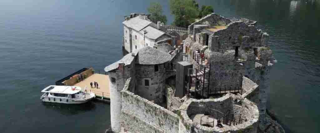
The dominant feature of the eastern islet remains its curtain wall system, which follows the irregular profile of the natural rock base in the manner consistently noted in historical and descriptive sources. This wall-to-rock conformity is architecturally significant in two related senses. It indicates that the builders of the Rocca Vitaliana did not attempt to regularise the islet’s perimeter by constructing a level retaining platform above the waterline and then building a regular-plan fortress upon it — a technique that was available and deployed elsewhere in the period — but instead treated the rock surface itself as the lowest structural element of the wall assembly. The visual result, perceptible from the shore and from boats circling the islets, is a masonry profile that rises directly from the water surface at angles that mirror the underlying rock face, producing an apparent continuity between the geological and the constructed that contributes substantially to the fortress’s distinctive silhouette and to its romantic visual power.
Within this outer curtain, the surviving spatial structure of the eastern islet divides into at least two main courtyard areas identifiable from the restoration project. The Vitaliana Courtyard (Corte Vitaliana), the primary internal enclosure associated with the Borromeo-period construction, and the Malpaga Courtyard (Corte Malpaga), which preserves or references the approximate footprint of the earlier medieval structure, together articulate the fortress’s internal organisation. The existence of a named Malpaga Courtyard within the Borromeo-period fabric is architecturally eloquent: it suggests that the builders of the Vitaliana were aware of and responding to the pre-existing spatial organisation of the demolished Malpaga, choosing to acknowledge the earlier layer in the arrangement of the new construction rather than erasing its spatial memory entirely. Ancient inscriptions in the courtyard stonework, documented during the restoration, record aspects of the fortification’s history in carved stone that supplemented archival sources and provided physical anchors for the chronological sequence.
The main keep, which rises to its greatest surviving height on the eastern islet, is the most conspicuous element of the visual profile seen from the western shore. The towers of the Vitaliana retain portions of their original battlemented parapets, a survival that confirms both the relative solidity of the original Borromeo-period construction and the disciplined approach of the recent restoration, which prioritised stabilisation of existing fabric over reconstruction of missing elements. The frescoed room revealed and documented during the restoration is a significant architectural finding: it demonstrates that the Rocca Vitaliana incorporated residential and representative spaces appropriate to a Borromeo count’s fortified residence, with painted wall decoration signifying elite inhabitation and the cultural ambitions of the patron, rather than being a purely functional garrison barracks indifferent to the visual character of its interiors.
A chapel within the complex further confirms the residential and representative character of the Borromeo-period construction. Military and residential chapels were standard features of Italian Renaissance fortified establishments of any significance, providing a liturgical space for the garrison and affirming the religious legitimacy and piety of the lord’s rule in a highly visible architectural form. The chapel’s presence at the Cannero Vitaliana aligns it with the broader pattern of Borromeo architectural patronage visible across their Lake Maggiore properties, in which religious provision was consistently incorporated alongside military or palatial construction.
The western islet presents a more fragmentary and desolate picture. Its primary surviving element is a partially destroyed tower, accompanied by scattered wall sections in varying states of deterioration and natural colonisation. Whether the western structure was always subsidiary to the eastern islet’s main fortress — a forward observation post or a secondary defensive position — or whether it represented an equally substantial investment in an earlier phase that was more completely ruined by time, weather, and successive sieges, is difficult to determine from available documentation without detailed archaeological investigation of the western island’s below-surface stratigraphy. The three-islet configuration as a whole, with the two fortified islets providing sight lines in multiple directions across the northern lake corridor, suggests a system designed for overlapping surveillance coverage rather than for concentration of defensive force at a single point.
Restoration, Conservation, and the Immersive Museum Experience
For the better part of the 20th and early 21st centuries, the Castelli di Cannero were accessible only to the eye: visitors could observe the ruins from the western shore or from a boat circling the islets, but the deteriorated state of the masonry made landing and internal access unsafe, and no sustained conservation programme had addressed the site’s structural decline. The ruins accumulated a paradoxical cultural status — widely photographed, consistently cited as one of Lake Maggiore’s defining scenic landmarks, routinely described in travel literature as among the most atmospheric ruins in northern Italy, and yet structurally untouched and gradually decaying further toward the point of irreversible collapse.
The reversal of this trajectory began in earnest in 2019, when the Borromeo family announced a programme of restoration and revalorisation for the Castelli di Cannero under the Terre Borromeo cultural management organisation. The project, which occupied approximately ten years in planning and execution before its public conclusion, integrated two parallel tracks: structural restoration of the surviving masonry to ensure safety and long-term fabric stability, and a systematic archaeological and archival investigation of the castle’s construction history, spatial organisation, and material record. The two tracks were deliberately combined, with archaeological findings informing structural decisions and conservation priorities throughout, rather than being treated as sequential phases in which investigation preceded intervention.
The restoration uncovered the frescoed room, the chapel, and the ancient inscriptions noted in the previous section. Archaeological excavation across the courtyards yielded finds from multiple occupation periods — from the 15th-century military phase through the subsequent domestic and subsistence uses described in historical sources — now displayed within the restored spaces of the eastern islet as part of the immersive museum collection. The archaeological investigation also, in the words of the official site documentation, conducted “in-depth archaeological and historical investigation, along with meticulous archival research,” that traced the castle’s history through the centuries with substantially greater precision than had been possible from archival sources alone.
The Castelli di Cannero opened to visitors in July 2025, offering an immersive museum experience that combines authenticated historical content with ambient audio-visual technology integrated into the restored spaces. Visitors travel by boat from the western shore to the eastern islet and move through the restored courtyards, chapel, frescoed room, main keep, and curtain walls while an audio experience narrates the castle’s layered history within the physical spaces where it was enacted. The Borromeo family’s Terre Borromeo programme, which also manages the Borromeo Islands (Isola Bella and Isola Madre) and the Rocca di Angera, frames the Castelli di Cannero as the northernmost and most distinctly military node of a coherent Lake Maggiore heritage network — a classification that positions the military-architectural character of the Cannero site as complementary to, rather than duplicating, the palatial Baroque island character of Isola Bella or the botanical emphasis of Isola Madre.
Visiting the Castelli di Cannero: Access, Orientation, and Lake Maggiore Context
Access to the Castelli di Cannero is exclusively by water. Boats depart several times daily from Cannero Riviera on Lake Maggiore’s western shore; seasonal services also operate from Cannobio to the north. The short crossing — approximately three hundred metres from the shore — takes only a few minutes, but provides the essential experiential frame for understanding the islet fortifications: the transition from the lakeside world of ordinary movement to the water-surrounded isolation of the castle site is a physical re-enactment of the defensive logic that justified the fortifications’ construction and maintenance across two centuries of Borromeo ownership. From the water at close range, the castle walls rising directly from the lake surface are visible at the scale and from the vantage point that would have confronted any approaching assailant in the 16th century.
Tickets and advance booking for the immersive museum experience are available through the official Terre Borromeo website (terreborromeo.it), and advance reservation is strongly recommended in summer months when boat capacity and time-slot availability are limited. The museum is closed on Mondays. The visit covers the main restored spaces of the eastern islet — the courtyards, chapel, frescoed room, keep, and curtain walls — combined with the audio experience, and typically requires sixty to ninety minutes. The open-air character of the majority of the visit means that weather conditions affect the experience significantly; the clearest conditions, which provide the most dramatic views across the northern lake toward the Swiss border, also provide the best light for examining the masonry textures and wall articulations that make the architectural history legible in the stone.
Cannero Riviera is accessible by car from the A26 motorway via the Verbania exit, or by the public Lake Maggiore navigation service connecting it to Verbania, Stresa, Arona, and the Swiss border town of Locarno. The nearest railway station with regional connections is Verbania-Pallanza (on the Domodossola–Milan line), from which the lake navigation service provides onward connections. The town itself is a small resort community relatively quiet by the standards of the more heavily visited central and southern lake resorts, making it a useful base for exploring the northern Lake Maggiore heritage landscape. The fortified medieval town of Cannobio, a few kilometres north, preserves a significant Romanesque church and lakeside historical centre. The Rocca di Angera, the Borromeo medieval fortress on the lake’s Lombard shore, is reachable by ferry from Stresa further south and offers useful comparison with the Cannero fortifications as a contrasting example of Borromeo military patronage on land rather than on water.
Frequently Asked Questions
What is the relationship between the Malpaga fortress and the Rocca Vitaliana?
The Malpaga and the Rocca Vitaliana are successive constructions on the same islets, not two structures that coexisted simultaneously. The Malpaga was the original medieval fortress built on the Cannero islets between the 13th and 14th centuries. In 1414, after the Visconti military expedition expelled the Mazzarditi and demolished the Malpaga, the structure was entirely razed, leaving no fabric above ground level. The Rocca Vitaliana, built by Count Ludovico Borromeo between 1519 and 1521, was therefore a completely new construction on the ruins of the demolished Malpaga — a new fortress on an old site, using the islets’ proven defensive qualities while building fresh walls on the bare rock that the demolished predecessor had revealed. Contemporary sources are explicit that the Malpaga was so thoroughly demolished that it left no visible trace; all architectural fabric visible today dates from the Borromeo construction phase of 1519 to 1521.
Who were the Mazzarditi and what was their historical significance on Lake Maggiore?
The Mazzarditi were five brothers from the Mazzardi family of Ronco, a hamlet of the municipality of Cannobio, who occupied the Malpaga fortress between 1403 and 1414. Their significance lies less in their individual identities, which are poorly documented, than in the historical type they represent: local strongmen who exploited a specific window of weak central authority — the political fragmentation of the Duchy of Milan between 1402 and 1412 — to establish a de facto autonomous lake lordship from an islet fortress. Between 1403 and 1414, operating from the water-surrounded Malpaga, the Mazzarditi controlled a stretch of northern Lake Maggiore by force, demanding tribute from lake traffic and suppressing opposition violently. Their expulsion in 1414 by Filippo Maria Visconti’s military force was part of the broader reassertion of Milanese ducal authority over the lake periphery; they were exiled for fifteen years rather than executed, and subsequently permitted to return to Cannobio. The legend that they were drowned in the lake with stones around their necks is consistently identified by historical sources as fictional.
How does the Borromeo family’s ownership of the Castelli di Cannero relate to their wider Lake Maggiore heritage?
The Borromeo family acquired the Cannero islets in 1441 through a feudal grant from the Duchy of Milan, connecting the site to a family presence on Lake Maggiore that spans five centuries and encompasses several landmark properties. The same family estate includes Isola Bella, the Baroque island palace and garden begun in the 17th century in the central lake; Isola Madre, the largest Borromeo island, developed primarily as a botanical garden; and the Rocca di Angera, a medieval fortress on the lake’s Lombard southern shore. The Castelli di Cannero represents the northernmost and most purely military of these Borromeo lake properties. Where Isola Bella and Isola Madre are expressions of aristocratic cultural patronage and horticultural ambition, the Cannero Vitaliana was a functional military installation responding to a specific strategic threat, and its architecture reflects that functional priority rather than the representational splendour of the later Baroque island developments. The Terre Borromeo programme manages all these properties and frames them together as a coherent Lake Maggiore heritage network.
What is the current state of the fortifications on the western islet versus the eastern one?
The two fortified islets are in significantly different states of preservation. The eastern islet bears the main Vitaliana stronghold and is the focus of the 2025 immersive museum: it includes substantial curtain walls following the rock contours, the Vitaliana Courtyard and Malpaga Courtyard spaces, the main keep, towers retaining portions of their original battlemented parapets, a chapel, and the frescoed room revealed during the restoration. The western islet has a more fragmentary survival: its primary surviving element is a partially destroyed tower surrounded by scattered wall sections in varying degrees of deterioration. The western islet is not part of the current visitor circuit. The asymmetry may reflect an original difference in the scale and intensity of construction on each islet, or differential effects of subsequent siege damage, weathering, and unmanaged deterioration across centuries of neglect.
Did the Rocca Vitaliana employ true Renaissance bastions in the military architectural sense?
Not in the strict technical sense. “Bastion” in precise military architectural usage refers to the angular, low-profile, earthwork-reinforced projecting elements of the trace italienne — the system of fortification developed by Italian engineers from the 1530s onward to counter heavy artillery. The Rocca Vitaliana, built in 1519 to 1521, predates the mature expression of this system by approximately a decade: the theoretical elaboration and practical deployment of angled bastion geometry across Italy’s major fortified cities primarily occurred from the 1530s onward. The Vitaliana therefore belongs to the category of transitional fortification — late-medieval tower-and-curtain construction adapted empirically to address gunpowder-era vulnerabilities — rather than to the mature bastion system. Its walls achieve angled faces largely through conformance to the irregular islet perimeter, a topographic accident that delivers similar ballistic benefits to designed angular geometry, though without the systematic mutual-flanking fire coverage that true bastion design provides.
Why did the Swiss pose a military threat that required fortification of the northern Lake Maggiore?
The Swiss Confederation’s military expansion into the territories north of Lake Maggiore — confirmed by their acquisition of the Canton Ticino in the aftermath of the Battle of Novara in 1513 — placed Swiss political and military authority at the northern end of the lake itself, creating a persistent threat of armed incursion southward along the lake corridor. For the Borromeo family, whose feudal holdings in the northern lake district were directly exposed to this threat axis, the northern lake represented an undefended border crossing. The lake itself, navigable north-south, could serve as an avenue of advance as easily as it served as a commercial corridor. The Rocca Vitaliana was designed to deny this avenue to Swiss forces by placing a permanently garrisoned stronghold at the critical northern narrows — a force multiplier that allowed a small garrison to interdict lake traffic and signal or resist any incursion more effectively than could any comparable investment in shore-based defences on either bank.
How long did the Rocca Vitaliana remain in active military use after its construction?
The Vitaliana’s active military phase was relatively concentrated. Built in 1519 to 1521 and tested by the two failed Sforza sieges of 1523 and 1524, the fortress served its intended defensive function for some decades after its completion. However, the geopolitical context that had justified its construction — the immediate threat of Swiss military incursion into the northern lake — gradually stabilised over the following decades as the broader Italian Wars reached their territorial settlement and Swiss expansion into Lombard territory ceased. By the later 16th century the Vitaliana’s active military role had transitioned toward a more residual garrison presence. By the 18th century, following the death of the last Count Ludovico to maintain an active interest in the site, the fortress was effectively abandoned to natural deterioration, and by the early 19th century it had achieved the state of romantic ruin that attracted Turner and other artists.
What did the Borromeo restoration reveal about the castle’s interior organisation?
The decade-long restoration and archaeological investigation substantially expanded the documentary record of the Castelli di Cannero beyond what archival research had established. Most significantly, the project revealed a frescoed room within the Vitaliana — one of the interior spaces bearing painted wall decoration — confirming that the fortress incorporated residential and representative spaces appropriate to a Borromeo count’s establishment, not merely a functional military barracks. A chapel was identified and documented within the complex. Archaeological excavation across the courtyard areas yielded objects from multiple occupation periods, from the 15th-century military phase through to the 18th-century domestic uses, now displayed in situ within the restored museum spaces. Ancient inscriptions in the courtyard stonework were documented and integrated into the historical narrative. The spatial organisation of the Vitaliana Courtyard and the Malpaga Courtyard was clarified, revealing a more complex internal spatial hierarchy than external observation had suggested.
How does the engineering of the Cannero islet fortifications compare to Japan’s Mizuki water fortress?
The comparison illuminates convergent independent development of hydraulic defensive engineering. Mizuki, a linear earthwork fortification built in 664 CE in Fukuoka Prefecture, Japan, faced the engineering problem of constructing a massive military barrier on soft, waterlogged alluvial ground — the plain between Hakata Bay and Dazaifu, through which the Mikasa River ran. The builders’ solution was to layer branches and leaves into the base of the earthwork before compacting rammed earth above, distributing the load across the unstable substrate to prevent sinking. The Cannero builders faced the inverse problem: not soft unstable ground but irregular bare rock, requiring hydraulic mortars to bond stone masonry to uneven submerged surfaces and protective stone at the wave-break zone to absorb wave energy. Both engineering traditions addressed the fundamental challenge of making a major defensive structure durable in conditions where water was the primary environmental threat to structural integrity. They arrived at materially different but functionally parallel solutions without any historical connection between them.
Is the Castelli di Cannero a UNESCO World Heritage Site, and how can visitors access it?
The Castelli di Cannero does not hold UNESCO World Heritage status. The site is an important cultural heritage monument under Italian law and is managed by the Borromeo family’s Terre Borromeo cultural programme, but it has not been the subject of a UNESCO inscription process. Visitors interested in UNESCO heritage in the broader northern Italian lake context should note that the fortifications of Peschiera del Garda, on Lake Garda, are part of the inscribed “Venetian Works of Defence between the 16th and 17th Centuries: Stato da Terra – Western Stato da Mar” (inscribed 9 July 2017). Access to the Castelli di Cannero is exclusively by boat from Cannero Riviera, with tickets and advance booking available at terreborromeo.it. The museum is closed on Mondays. The boat crossing from the western shore takes a few minutes, and the visit typically lasts sixty to ninety minutes through the restored courtyards, chapel, frescoed room, keep, and curtain walls of the eastern islet.