Hawaii Volcanoes National Park UNESCO Guide: Complete Heritage & Natural Wonder
Hawaii Volcanoes National Park stands as one of Earth’s most dynamic natural laboratories, where two of the world’s most active volcanoes shape landscapes in real time and ancient Hawaiian traditions merge with geological forces that built an entire archipelago. Recognized by UNESCO as a World Heritage Site in 1987, this remarkable preserve encompasses the summit and slopes of both Mauna Loa and Kilauea volcanoes, protecting ecosystems that range from sea level to alpine heights above 13,000 feet. The park offers visitors an unparalleled opportunity to witness ongoing volcanic processes, explore diverse ecological zones found nowhere else on Earth, and connect with Native Hawaiian cultural heritage deeply rooted in these sacred landscapes.
Key Takeaways About Hawaii Volcanoes National Park
- UNESCO World Heritage Status: Inscribed in 1987 under geological criterion (viii) for exceptional examples of ongoing volcanic island-building processes, making it one of the world’s premier sites for understanding shield volcano formation and evolution.
- Dual Volcanic Giants: The park protects significant portions of Mauna Loa, the largest volcanic mass on Earth when measured from the ocean floor, and Kilauea, among the planet’s most active and accessible volcanoes demonstrating continuous eruptive activity.
- Seven Distinct Ecosystems: Elevation gradients from Pacific coastline to alpine summit create seacoast, lowland forest, mid-elevation woodland, rainforest, upland forest, subalpine, and alpine zones, each supporting unique assemblages of endemic species.
- Sacred Cultural Landscape: Native Hawaiians revere Kilauea as the home of Pele, the fire goddess, and the park preserves ancient villages, heiau temples, petroglyphs, and other archaeological sites demonstrating 700 years of continuous cultural connection.
- Extraordinary Endemism: Geographic isolation created one of Earth’s highest concentrations of endemic species, including six Hawaiian honeycreeper species, native forest birds, giant tree ferns, and unique invertebrates found nowhere else globally.
- Ongoing Geological Transformation: Active lava flows continuously reshape coastlines and create new land, offering scientists and visitors direct observation of the volcanic processes that formed the entire Hawaiian archipelago over millions of years.
People Also Ask About Hawaii Volcanoes National Park UNESCO Site
Why is Hawaii Volcanoes National Park a UNESCO World Heritage Site?
Hawaii Volcanoes National Park earned UNESCO World Heritage designation in 1987 under criterion (viii) for representing outstanding examples of significant ongoing geological processes. The park demonstrates exceptional island-building through active volcanic activity, showcasing the most recent stage in the continuing geological formation and transformation of the Hawaiian archipelago. Mauna Loa and Kilauea, two of the world’s most active and scientifically studied volcanoes, provide unparalleled opportunities to observe shield volcano formation, lava flow dynamics, and the succession of ecological communities that colonize fresh volcanic landscapes. The site’s global significance stems from its accessibility for scientific research, its role in advancing volcanological understanding, and its demonstration of how volcanic processes create and continuously modify oceanic island ecosystems.
What makes the volcanoes in Hawaii Volcanoes National Park scientifically important?
Kilauea and Mauna Loa represent two of the most extensively studied and best-understood volcanoes on Earth, providing fundamental insights into hotspot volcanism and shield volcano behavior. Kilauea’s near-continuous eruptive activity and accessible lava flows have enabled scientists to develop comprehensive models of volcanic plumbing systems, magma storage and transport, and eruption forecasting. Mauna Loa, measured from its base on the ocean floor, constitutes the greatest volcanic mass on the planet, rising almost nine kilometers from seafloor to summit and covering nearly 90 percent of its surface with lava flows less than 4,000 years old. These volcanoes sit above the Hawaiian hotspot, a stationary mantle plume that has created the entire island chain as the Pacific Plate moves northwest, making them living textbooks for understanding how volcanic islands form, evolve, and eventually erode.
How does Pele connect to Hawaii Volcanoes National Park?
Pele, known as Pelehonuamea or “she who shapes the sacred land,” is the Hawaiian goddess of fire and volcanoes whose spiritual home resides in Halema’uma’u Crater at Kilauea’s summit. Native Hawaiian tradition identifies Pele as both creator and transformer, her volcanic eruptions simultaneously destroying existing landscapes and generating new land through flowing lava. For many Hawaiians, Pele represents ‘ohana (family) and serves as an ‘aumakua (family deity) for people in the Puna and Ka’u districts. Visitors encounter her presence throughout the park through traditional offerings of flowers and ti leaves near craters, ‘ohelo berries sacred to Pele growing along crater rims, and the cultural protocol of asking permission before entering volcanic landscapes. The enduring reverence for Pele demonstrates how Native Hawaiian spirituality remains intimately connected to ongoing geological processes, viewing eruptions not as disasters but as Pele’s continuous work of land creation and renewal.
What unique ecosystems exist in Hawaii Volcanoes National Park?
The park’s dramatic elevation range from sea level to Mauna Loa’s summit at 13,678 feet creates seven distinct ecological zones, each hosting assemblages of endemic species adapted to specific environmental conditions. Coastal lowlands support native strand vegetation and archaeological sites. Lowland forests contain ‘ōhi’a and introduced species. Mid-elevation woodlands transition into montane rainforests featuring some of Hawaii’s last remaining old-growth ‘ōhi’a and giant hāpu’u tree fern stands. Upland forests support endemic birds including Hawaiian honeycreepers particularly vulnerable to avian malaria. Subalpine zones exhibit increasingly sparse vegetation adapted to temperature extremes and high winds. Alpine deserts near Mauna Loa’s summit challenge species with freezing temperatures and minimal precipitation. Fresh lava flows demonstrate primary succession as pioneer species like ‘ae ferns and ‘ōhelo shrubs colonize barren rock, gradually building soil that enables more complex plant communities to establish.
Extended multi-day tours – 5+ days
Featured Hawaii Multi-Day Tour Packages
5 days
USA – Hawai: Tropical Dreams – 5 days
- ✓ Comprehensive Hawaii tour
- ✓ Expert local guides included
- ✓ All accommodation arranged
- ✓ Transportation provided
8 days
Hawaiian Explorer (Intra Tour Air Hawaii 2 Flights)
- ✓ Comprehensive Hawaii tour
- ✓ Expert local guides included
- ✓ All accommodation arranged
- ✓ Transportation provided

7 days
7 Day Hawaii Experience (Bilingual: Chinese, English)
- ✓ Comprehensive Hawaii tour
- ✓ Expert local guides included
- ✓ All accommodation arranged
- ✓ Transportation provided

10 days
Hawaii with Oahu, Maui & the Big Island (Classic, With The Big Island)
- ✓ Comprehensive Hawaii tour
- ✓ Expert local guides included
- ✓ All accommodation arranged
- ✓ Transportation provided
Multi-day tour packages powered by TourRadar. Prices and availability subject to change.
Introduction: Understanding Hawaii Volcanoes National Park’s Global Significance
Standing at the rim of Halema’uma’u Crater as steam vents hiss and the earth trembles beneath your feet, you witness geological forces that have operated continuously for hundreds of thousands of years, building the Hawaiian Islands grain by grain through countless eruptions and lava flows. Hawaii Volcanoes National Park, established in 1916 and designated as a UNESCO World Heritage Site in 1987, protects 335,000 acres of dynamic volcanic landscapes where Mauna Loa and Kilauea continue the island-building processes that created the entire Hawaiian archipelago. The park represents far more than scenic vistas and dramatic eruptions. It functions as a living laboratory where scientists study volcanic mechanisms, ecologists observe how life colonizes barren lava, and cultural practitioners maintain spiritual connections to landscapes their ancestors revered for centuries.
The UNESCO inscription recognized Hawaii Volcanoes National Park under criterion (viii) for geological processes, specifically for its exceptional demonstration of ongoing island formation through shield volcanism. Unlike explosive stratovolcanoes that produce violent eruptions, Hawaiian shield volcanoes typically generate relatively gentle effusive eruptions, allowing close observation of lava flows, fountain activity, and the gradual construction of massive volcanic edifices. This accessibility has made Kilauea and Mauna Loa among the most extensively studied volcanoes globally, contributing fundamental knowledge about volcanic behavior, hazard assessment, and the deep-Earth processes driving hotspot volcanism. The Hawaiian Volcano Observatory, established in 1912 and located within the park, pioneered modern volcanology techniques now applied to volcanic monitoring worldwide.
Beyond geological significance, the park preserves extraordinary biological diversity shaped by Hawaii’s extreme isolation. Located more than 2,000 miles from the nearest continent, the Hawaiian Islands developed ecosystems with higher rates of endemism than almost anywhere on Earth. Species that successfully colonized these remote islands evolved in isolation, producing unique birds, plants, insects, and other organisms found nowhere else. The park’s elevation gradients create multiple climate zones within a relatively compact area, from tropical coastlines receiving 200 inches of annual rainfall to alpine deserts experiencing freezing temperatures. This environmental diversity supports seven distinct ecological zones, each hosting specialized communities of endemic species struggling against threats from introduced predators, invasive plants, disease, and climate change.
Native Hawaiian cultural heritage permeates every aspect of the park. Long before Western contact, Hawaiians recognized the spiritual power of active volcanoes, developing rich traditions centered on Pele and her volcanic family. Archaeological evidence documents Hawaiian presence for at least 700 years, with coastal sites revealing ancient villages, heiau temples, petroglyphs carved into lava, and networks of trails connecting communities. The 1790 footprints preserved in volcanic ash capture a moment when warriors and families fled Kilauea’s explosive eruption, their impressions now protected under glass as tangible connections to pre-contact Hawaii. For contemporary Native Hawaiians, Kilauea remains a living deity’s home, not merely a geological feature, and the park works to balance public access with respect for sacred landscapes and cultural protocols.
The Biosphere Reserve designation in 1980 preceded UNESCO World Heritage inscription, recognizing the park’s value for conservation research and sustainable use. The original 88,000-hectare core protected under World Heritage listing grew substantially in 2004 when the Kahuku Unit added 47,000 hectares, providing additional protection for geological and biological resources. Currently, 73 percent of the park holds federal wilderness designation, ensuring the highest level of protection for its volcanic landscapes, native ecosystems, and cultural sites. Management challenges include controlling invasive species that threaten endemic plants and animals, protecting visitors from volcanic hazards including lava flows and toxic fumes, maintaining infrastructure damaged by earthquakes and eruptions, and addressing climate change impacts that may drive endemic species toward extinction.
The Two Great Volcanoes: Mauna Loa and Kilauea
Mauna Loa and Kilauea, the twin volcanic giants protected within Hawaii Volcanoes National Park, represent fundamentally different stages of shield volcano development despite their proximity. Mauna Loa, the older volcano, has built a massive dome spanning 4,170 meters above sea level, but its true scale becomes apparent only when measured from the ocean floor nearly nine kilometers below, making it the largest volcanic mass on Earth by volume. The volcano’s shield shape derives from countless fluid lava flows that spread widely from summit and rift zone vents, gradually constructing a low-angle edifice rather than the steep-sided cone typical of explosive volcanoes. Nearly 90 percent of Mauna Loa’s surface consists of lava flows less than 4,000 years old, demonstrating the remarkable productivity of Hawaiian volcanism.
Mauna Loa’s eruptions, while less frequent than Kilauea’s, produce voluminous lava flows capable of reaching the ocean within hours when vented from the volcano’s lengthy northeast or southwest rift zones. The summit caldera, Moku’aweoweo, measures roughly 6 by 8 kilometers and sits within an older, larger caldera structure, evidence of repeated cycles of summit inflation, eruption, and caldera collapse. Historical eruptions occurred in 1975, 1984, and most recently in November 2022, when fissures opened along the northeast rift zone producing spectacular lava fountains and flows visible throughout the island. Scientists monitor Mauna Loa continuously, tracking ground deformation, seismicity, and gas emissions to forecast future eruptions, recognizing that flows from this massive volcano threaten communities downslope.
Kilauea, by contrast, maintains nearly continuous eruptive activity, making it among the world’s most active volcanoes and certainly the most accessible for direct observation. Topographically appearing as merely a bulge on Mauna Loa’s southeastern flank, Kilauea nevertheless operates as a completely independent volcano with its own magma plumbing system extending more than 60 kilometers deep. The summit caldera contains Halema’uma’u Crater, traditionally considered Pele’s home, which has hosted various lava lake configurations over recorded history. From 2008 through 2018, a persistent lava lake bubbled within Halema’uma’u, drawing visitors who could safely observe glowing molten rock from nearby overlooks.
The dramatic 2018 eruption sequence fundamentally transformed Kilauea’s summit and lower east rift zone. Beginning in May 2018, the summit lava lake drained rapidly as magma migrated underground to erupt from fissures in Leilani Estates, 25 miles downrift. This produced voluminous lava flows that destroyed 700 homes and added new land to the island’s coastline. Simultaneously, the summit experienced hundreds of collapse events as the magma reservoir emptied, deepening Halema’uma’u Crater dramatically and causing magnitude 5+ earthquakes that damaged park infrastructure including the Jaggar Museum and Hawaiian Volcano Observatory buildings, subsequently demolished. Eruptive activity ceased in August 2018, followed by a relative lull until December 2020 when a new lava lake began forming within the dramatically enlarged Halema’uma’u Crater, which has continued with intermittent activity.
The geological relationship between these two volcanoes illustrates the progression of Hawaiian volcanism. Mauna Loa, despite its immense size, represents a maturing shield volcano gradually reducing its eruptive frequency. Kilauea, younger and more active, remains in the vigorous shield-building stage, adding substantial new rock to its edifice through frequent eruptions. Both volcanoes sit above the Hawaiian hotspot, a mantle plume rising from deep within Earth. As the Pacific Plate moves northwest at roughly 7-9 centimeters annually, this stationary hotspot will eventually build new volcanoes southeast of the Big Island, a process already underway with Kama’ehuakanaloa (formerly Lo’ihi), an active submarine volcano growing on the seafloor.
Geological Features and Volcanic Landscapes
The park’s volcanic landscapes reveal the full spectrum of Hawaiian eruptive processes and their products. Fresh lava flows, still warm months after eruption, display the classic Hawaiian lava types: smooth, ropy pahoehoe and rough, clinkery ‘a’a. Pahoehoe forms when fluid lava flows slowly enough for its surface to solidify into a thin skin while molten lava continues moving beneath, creating characteristic ropy textures and sometimes inflating into tumuli or pressure ridges. As flows cool and gas escapes, pahoehoe can transition to ‘a’a, forming jumbled masses of sharp, broken lava fragments that make walking treacherous. Both types appear throughout the park, with pahoehoe dominating where slopes remain gentle and ‘a’a forming on steeper terrain or where higher eruption rates produce more vigorous flows.
Lava tubes represent one of the park’s most fascinating features, forming when the surface of a pahoehoe flow solidifies while molten lava continues flowing beneath. As eruptions wane, lava drains from these underground conduits, leaving hollow tunnels that may extend for miles. Nahuku, commonly known as Thurston Lava Tube, provides easy access to this phenomenon via a paved trail through a section large enough for visitors to walk upright. The tube’s ceiling displays features called lavacicles where dripping lava solidified while hanging, and benches on the walls mark former lava level heights. Kazumura Cave, at roughly 40 miles long, represents the world’s longest known lava tube system, though it lies largely outside park boundaries and requires special permission to access.
Volcanic craters dot the landscape, each recording different eruptive styles and periods of activity. Halema’uma’u dominates Kilauea’s summit caldera, its dimensions constantly changing as eruptions fill the crater with lava or collapse events deepen it. Kilauea Iki, a smaller crater adjacent to the main caldera, preserves evidence of the spectacular 1959 eruption that produced lava fountains reaching 1,900 feet in height. Today, visitors can hike across Kilauea Iki’s solidified lava lake floor, observing how the once-molten surface has cooled, cracked, and begun the slow process of supporting pioneer plant species. The crater’s walls display layers of cooled lava representing different fountain episodes, and steam vents still hiss where rainfall infiltrates and contacts hot rock below.
Pit craters form through different mechanisms than explosive eruptions, developing when magma drains from shallow chambers and overlying rock collapses into the void. Chain of Craters Road descends through numerous pit craters before reaching the coast, each crater representing localized collapse along Kilauea’s east rift zone. These craters lack the tephra deposits surrounding explosive volcanic vents, instead showing sheer walls of layered basalt dropping into empty chambers. Some craters host sulfur deposits where volcanic gases interact with groundwater, creating colorful yellow crusts and acidic conditions that prevent plant growth.
Steam vents and fumaroles release volcanic gases throughout active areas, their temperatures and compositions providing insights into subsurface conditions. The Sulphur Banks area near the summit demonstrates how hydrogen sulfide and sulfur dioxide gases interact with groundwater and atmospheric oxygen, depositing elemental sulfur and creating acidic conditions. Persistent steam plumes mark locations where groundwater contacts hot rock, generating steam visible from miles away. These features pose hazards through toxic gas emissions and unstable ground, requiring careful monitoring and visitor management. The park maintains networks of gas sensors to warn of dangerous conditions and closes areas when volcanic fume concentrations exceed safe thresholds.
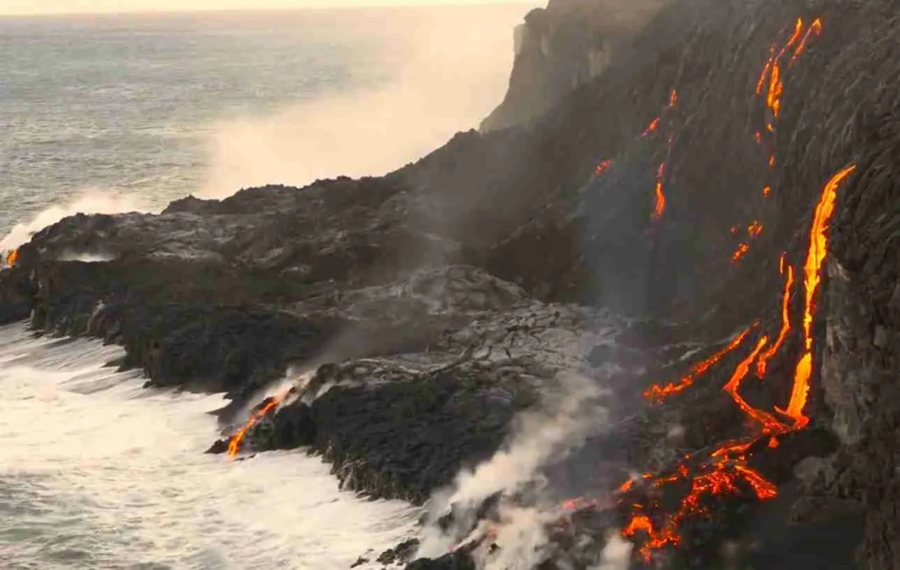
Coastal features demonstrate how volcanic processes extend into the ocean. When lava enters the sea, violent steam explosions fragment the molten rock into black sand, which currents transport and deposit as beaches. Repeated lava flows can extend the coastline, creating new land called lava deltas that remain dangerously unstable for years after formation. The 2018 eruption added substantial new land area along Kilauea’s southeast coast, though much of this remains inaccessible due to unstable lava benches that may collapse suddenly into the ocean. Littoral lava tubes form where ocean waves chill lava flow surfaces, creating hollow tubes within the surf zone that differ from inland lava tubes.
The Hawaiian Hotspot and Island Formation
Understanding Hawaii Volcanoes National Park requires grasping the hotspot theory that explains the entire Hawaiian archipelago’s formation. Unlike volcanoes at tectonic plate boundaries where plates collide or separate, Hawaiian volcanoes arise from a stationary mantle plume deep within Earth. This plume, heated by radioactive decay or rising from the core-mantle boundary, ascends through the mantle as a column of abnormally hot rock. Where this plume intersects the Pacific Plate, partial melting generates magma that rises through the oceanic crust, eventually building volcanic islands at the surface. The Pacific Plate’s northwest motion carries each volcano away from the hotspot, cutting it off from its magma source and eventually leading to dormancy and erosion.
This conveyor belt process created the entire Hawaiian-Emperor seamount chain stretching 6,000 kilometers across the Pacific. The oldest volcanic remnants, now submerged seamounts near the Kamchatka Peninsula, erupted more than 80 million years ago. As you trace the chain southeast, each volcano becomes progressively younger, culminating in the currently active volcanoes of the Big Island. Kauai, the oldest major Hawaiian island, emerged roughly 5 million years ago and now shows substantial erosion with deep valleys and no volcanic activity. Oahu formed 3-4 million years ago from two shield volcanoes now deeply eroded. Maui’s Haleakala last erupted around 1790, showing the transition toward dormancy. The Big Island, Hawaii’s youngest island, currently sits directly above the hotspot, explaining why it hosts all five of Hawaii’s historically active volcanoes.
The progression from vigorous shield-building through dormancy to erosion follows predictable stages. Young shield volcanoes like Kilauea produce frequent eruptions of fluid basaltic lava, building broad, gently-sloped edifices through thousands of individual flows. As volcanoes move away from the hotspot, eruption rates decline and magma compositions sometimes evolve, occasionally producing more explosive eruptions. Eventually, magma supply ceases entirely and the volcano enters the erosional stage, where wind, rain, and ocean waves gradually wear down the edifice. Submarine landslides can remove huge sections of volcanic islands, creating Hawaii’s remarkably steep submarine slopes. Given enough time, volcanic islands erode to sea level, becoming atolls with fringing reefs, and eventually disappear entirely beneath the waves.
Kama’ehuakanaloa, the submarine volcano growing on the seafloor about 35 kilometers southeast of the Big Island, represents the hotspot’s future. This seamount rises more than 3,000 meters above the ocean floor but remains about 1,000 meters below sea level. Active eruptions have been detected, and scientists predict Kama’ehuakanaloa will eventually emerge as a new island, though this process may require tens of thousands of years. The volcano’s existence confirms that the Hawaiian hotspot remains active and will continue building new islands as long as the Pacific Plate continues its northwest motion.
Research at Hawaii Volcanoes National Park has proven fundamental to understanding hotspot volcanism globally. The accessible nature of Hawaiian eruptions enabled pioneering volcanologists to develop techniques for monitoring ground deformation, gas emissions, and seismic signals that now provide standard tools for volcanic surveillance worldwide. Studies of Hawaiian lava flow behavior established models for predicting flow paths and advance rates, critical information for hazard assessment. The park’s geological record, preserved in layered lava flows and ash deposits, allows reconstruction of volcanic activity spanning hundreds of thousands of years, revealing patterns of eruption frequency, lava production rates, and how shield volcanoes evolve through time.
Cultural Heritage and Native Hawaiian Connections
The volcanic landscapes preserved within Hawaii Volcanoes National Park hold profound spiritual significance for Native Hawaiians, who recognize these mountains not merely as geological features but as manifestations of divine power and ancestral connections. Pele, the fire goddess, dominates volcanic spirituality, her presence felt in every eruption, lava flow, and steaming vent. Traditional chants and oral histories describe Pele’s journey from Tahiti, fleeing her sister Namaka, the sea goddess, who pursued her across the Pacific. Landing first on Kauai, Pele dug fire pits seeking a home safe from Namaka’s waves. Each attempt ended in flooding as ocean water invaded her excavations. Island by island, Pele traveled southeast, the geological progression of Hawaiian volcanism encoded in cultural narrative, until finally establishing her permanent home in Halema’uma’u Crater on Kilauea, where the volcano’s active eruptions demonstrate her continued residence.
Pele’s mythology extends beyond creation stories to encompass complex family relationships and encounters with mortals. Her siblings include Kamohoali’i the shark god, Kane Milohai the sky father, and numerous sisters named Hi’iaka, most famously Hi’iakaikapoliopele. These family members represent various natural forces, their stories explaining relationships between fire, ocean, wind, and rain. Pele’s volatile temperament, demonstrated through sudden eruptions and unpredictable lava flows, reflects her mythological character as passionate, jealous, and fierce. She appears in legend as both a beautiful young woman and an elderly kahuna, testing mortals’ generosity and punishing those who show disrespect. Many contemporary accounts describe encounters with an old woman seeking assistance along roads near the volcano, vanishing mysteriously after receiving help or being refused.
Cultural protocols surrounding volcanic areas emphasize respect and proper behavior. Traditional practice requires asking Pele’s permission before entering her domain, typically through silent prayer or proper chant. The ‘ohelo berries growing along Halema’uma’u’s rim remain sacred to Pele, and eating them without first offering some to the goddess represents serious disrespect. The widespread prohibition against removing lava rocks reflects both environmental ethics and spiritual beliefs that taking pieces of Pele’s body brings misfortune. Park staff regularly receive packages from former visitors returning rocks and explaining the run of bad luck they experienced, whether coincidental or not, after taking volcanic souvenirs. This curse concept, while partially a modern invention, aligns with deeper Hawaiian values about leaving natural places undisturbed.
Archaeological sites throughout the park document sustained Hawaiian habitation and use spanning at least 700 years. Coastal areas contain the densest concentrations of cultural resources, including house platforms, heiau temples, petroglyphs, fishing shrines, and canoe landings. The Waha’ula heiau near the coast served important ceremonial functions before being destroyed by lava flows in 1997, demonstrating how Pele’s volcanic activity has repeatedly transformed sacred landscapes. Pu’u Loa, a lava shield on the coastal plain, hosts more than 23,000 petroglyphs, one of Hawaii’s largest concentrations of rock art. Many petroglyphs mark locations where families buried umbilical cords of newborns, ensuring the child’s connection to the land.
The 1790 footprints preserved in Kilauea’s volcanic ash provide haunting evidence of the volcano’s explosive power and its impact on Native Hawaiian communities. When Kilauea erupted violently during a period of warfare between rival chiefs, a party of warriors, families, and non-combatants fled along trails near the summit. The eruption produced a pyroclastic surge that overwhelmed some travelers, whose footprints remain impressed in ash that later hardened. These prints, protected under glass shelters, show men, women, and children walking together, some carrying burdens, a snapshot frozen in time of people fleeing volcanic fury. The site reminds visitors that volcanic landscapes have always posed hazards to Hawaiian communities even as they provided resources and spiritual connection.
Traditional Hawaiian land management recognized different environmental zones and their proper uses. Coastal areas provided fishing, shellfish gathering, and salt production. Lower forests supplied timber, medicinal plants, and bird feathers for ceremonial cloaks. Alpine areas hosted quarries for dense basalt used in tools. This vertical integration of resources, with individual ahupua’a land divisions stretching from mountain to sea, ensured communities accessed diverse environments and products. The park works to integrate traditional knowledge with contemporary management, consulting with Native Hawaiian cultural practitioners on protocols for sacred sites, appropriate public access, and interpretation of volcanic landscapes that remain spiritually significant for many Hawaiians today.
Ecosystems and Biodiversity Across Elevation Zones
Hawaii Volcanoes National Park’s extraordinary biodiversity derives directly from Hawaii’s extreme isolation and the park’s dramatic elevation gradients. Located more than 2,000 miles from the nearest continent, the Hawaiian Islands developed biota through long-distance colonization by species capable of crossing vast ocean barriers. Birds arrived on wind currents, insects hitchhiked on drifting vegetation or were carried by storms, and plant seeds traveled in bird digestive systems or floated on currents. Once established, these founding populations evolved in isolation, producing endemic species found nowhere else on Earth. The park protects habitats from sea level to Mauna Loa’s summit at 13,678 feet, creating environmental conditions ranging from tropical rainforest receiving 200 inches of annual precipitation to alpine desert experiencing freezing temperatures and minimal rainfall.
Coastal lowlands, though limited in the park, support strand vegetation adapted to salt spray, intense sun, and sandy or rocky substrates. Native plants like naupaka and beach morning glory stabilize coastal areas while providing habitat for seabirds. Archaeological sites concentrate along the coast where Hawaiians established villages, temples, and fishing shrines, their presence documented through house platforms, trails, and petroglyphs. Coastal forests once extended inland but have been heavily modified by introduced species and past land use. The park protects remaining fragments of native coastal ecosystems increasingly rare elsewhere in Hawaii.
Lowland forests between sea level and 3,000 feet elevation historically supported diverse native plant communities dominated by ‘ōhi’a trees, but introduced species now pervade many areas. ‘Ōhi’a, endemic to Hawaii, demonstrates remarkable adaptability across elevation and moisture gradients, appearing as shrubs in harsh alpine environments and reaching 80 feet in optimal rainforest conditions. The tree’s bright red pom-pom flowers provide nectar for native honeycreepers and other forest birds. Currently, rapid ‘ōhi’a death, a fungal disease discovered in 2014, threatens ‘ōhi’a forests statewide, killing millions of trees and potentially transforming ecosystems built around this keystone species. The park implements strict biosecurity protocols to prevent disease spread between forest areas.
Mid-elevation woodlands transition between lowland and montane forests, supporting mixtures of native and introduced species. Invasive grasses, particularly fountain grass, create continuous fuel beds enabling wildfires that historically occurred rarely in wet Hawaiian forests. These fires kill native plants adapted to moist conditions and favor fire-adapted invasive species, creating a feedback loop that converts native ecosystems to introduced grasslands. The park actively manages invasive grasses through manual removal, herbicide treatment, and restoration planting, though controlling widespread invasions across hundreds of thousands of acres exceeds available resources.
Montane rainforests between 3,000 and 6,000 feet represent Hawaii Volcanoes National Park’s most intact native ecosystems. The ‘Ōla’a Forest tract protects one of Hawaii’s largest remaining old-growth ‘ōhi’a and tree fern stands, hosting species assemblages similar to forests that once covered vast areas of the Hawaiian Islands. Hāpu’u tree ferns reach 35 feet tall, their fronds creating canopy layers beneath emergent ‘ōhi’a. These forests support the park’s richest bird communities, including six Hawaiian honeycreeper species: ‘apapane, ‘i’iwi, ‘amakihi, Hawaiian creeper, ‘akiapōlā’au, and ‘ākepa. Three of these species face global extinction threats from habitat loss, introduced predators, and especially avian malaria spread by introduced mosquitoes.
Hawaiian honeycreepers evolved from a single finch ancestor into more than 50 species exhibiting remarkable bill diversity adapted for different feeding strategies. The ‘apapane’s short, curved bill efficiently extracts nectar from ‘ōhi’a flowers. The ‘akiapōlā’au employs an extraordinary bill with straight lower mandible for excavating wood and curved upper mandible for probing, functioning like a built-in woodpecker toolkit. These specialized adaptations made honeycreepers vulnerable when introduced diseases, predators, and habitat destruction arrived with human colonization. More than half of known honeycreeper species are now extinct, and most survivors face uncertain futures. The park’s high-elevation forests currently remain largely mosquito-free, providing refugia where honeycreepers avoid avian malaria, but climate warming pushes mosquito ranges upslope, potentially eliminating disease-free habitat within decades.
Upland forests grade into subalpine zones between 6,000 and 9,000 feet where decreasing temperatures and increasing exposure limit plant growth. Vegetation becomes increasingly stunted, with ‘ōhi’a appearing as shrubs rather than trees and open grasslands interspersed with native shrubs. Mamane trees, important food sources for endangered palila finches elsewhere in Hawaii, occur sporadically. These open habitats attract native raptors including the ‘io or Hawaiian hawk and the pueo or Hawaiian short-eared owl, both endemic subspecies. The endangered nēnē, Hawaii’s state bird and the world’s rarest goose, inhabits these elevations, feeding on native plants and nesting in lava crevices. Conservation programs successfully brought nēnē back from near extinction through captive breeding and reintroduction.
Alpine zones above 9,000 feet approach environmental limits for plant survival. Near Mauna Loa’s summit, temperatures drop below freezing regularly, precipitation falls mainly as snow in winter, and intense solar radiation, thin air, and strong winds challenge organisms. Only the hardiest native plants persist here, including small ‘ōhi’a shrubs, bunch grasses, and specialized herbs adapted to extreme conditions. The silversword family, though more diverse on Haleakala, includes alpine specialists with rosettes of silvery leaves that reflect intense sunlight. These barren volcanic deserts support minimal animal life beyond occasional insects and spiders, yet even here, endemic species demonstrate the evolutionary adaptations enabling life to persist in Hawaii’s most extreme environments.
Lava flows of different ages create a mosaic of successional stages across the park. Fresh lava, sterile and barren immediately after cooling, gradually weathers as rainwater dissolves minerals and begins forming primitive soils. Pioneer species, particularly ‘ae ferns and ‘ōhelo shrubs, colonize young flows within years or decades, their roots penetrating cracks where moisture accumulates. These pioneers trap windblown debris, their decomposing tissues adding organic matter that improves moisture retention and nutrient availability. Over centuries, native forest species establish, eventually creating mature ecosystems difficult to distinguish from forests on older substrates. This successional process operates faster in wet climates than dry areas, producing the park’s environmental diversity where neighboring lava flows erupted decades apart but support substantially different plant communities.
Endemic Species and Conservation Challenges
Hawaii’s geographic isolation created evolutionary laboratories where colonizing species diversified into forms found nowhere else on Earth, producing endemism rates among the world’s highest. The park protects numerous endemic plants, birds, insects, and other organisms struggling against threats that arrived with human colonization. Native Hawaiian ecosystems evolved without mammalian predators, large herbivores, or many disease organisms, leaving species vulnerable when these threats appeared. Contemporary conservation efforts focus on controlling invasive species, protecting critical habitats, monitoring population trends, and when necessary, implementing intensive management including captive breeding and translocation to prevent extinctions.
Hawaiian honeycreepers represent the park’s most imperiled vertebrates. The Hawaiian creeper, ‘akiapōlā’au, and ‘ākepa all carry endangered status, their populations restricted to high-elevation forests where avian malaria and avian pox remain rare. These mosquito-transmitted diseases devastate honeycreeper populations at lower elevations, effectively confining species to mountain refugia. As climate change warms high-elevation forests, mosquito ranges expand upslope, potentially eliminating disease-free habitat entirely. The park documents honeycreeper elevational movements, tracking whether birds migrate seasonally between elevations and thereby expose themselves to disease. Understanding these movement patterns informs conservation strategies including possible mosquito control, captive insurance populations, and potentially controversial genetic modifications that could render mosquitoes incapable of transmitting avian malaria.
The ‘i’iwi, with brilliant scarlet plumage and deeply curved bill adapted for tubular flower nectar, faces extinction across much of its former range despite remaining locally common in the park’s disease-free forests. Recent population declines suggest climate-driven disease expansion may already be impacting high-elevation populations. The ‘apapane remains the most abundant native forest bird, its adaptability and disease resistance enabling persistence across wider elevation ranges than other honeycreepers. Even this resilient species, however, shows population declines in areas where avian malaria becomes established.
The nēnē exemplifies conservation success through intensive management. By the 1950s, hunting and introduced predators reduced nēnē populations to approximately 30 individuals, pushing the species toward extinction. Captive breeding programs established at the park and elsewhere produced birds for release, gradually rebuilding wild populations. Today, several hundred nēnē inhabit the park’s volcanic landscapes, feeding on native berries and grasses while nesting in lava crevices safe from ground predators. The species still faces threats from vehicle strikes along park roads, predation by introduced mongooses and feral cats, and loss of lowland habitat to development and invasive species. Ongoing management includes predator control, habitat restoration, and visitor education to reduce road mortality.
Native plants face severe pressure from invasive species that outcompete, displace, or fundamentally alter ecosystems. Fountain grass and other introduced fire-prone grasses create fuel continuity enabling wildfires that kill native vegetation adapted to wet conditions without regular fire. After fires, invasive grasses quickly recolonize burned areas, preventing native forest recovery and establishing positive feedback cycles where more grass produces more frequent fires. The park conducts extensive invasive grass control through herbicide application, manual removal, and strategic fencing to exclude feral ungulates that spread grass seeds and prevent native plant regeneration.
Feral pigs represent particularly damaging invasive mammals, rooting through native forests searching for invertebrates, native plant roots, and fallen fruit. This rooting destroys vegetation, creates wallows that become mosquito breeding habitat, and disperses invasive plant seeds. Feral goats browse native shrubs and trees, preventing regeneration and potentially eliminating species from accessible areas. The park eliminated or substantially reduced ungulate populations through systematic hunting and fencing, protecting key native ecosystems. Where feral ungulates have been removed, native vegetation demonstrates remarkable recovery, with rare plants reappearing and native forest composition improving within years.
Invasive shrubs and trees pose challenges as difficult as invasive grasses. Banana poka, a passion fruit vine from South America, smothers native forest canopies, preventing light penetration and killing trees through girdling. Himalayan ginger forms dense monocultures in wet forests, excluding native understory plants and reducing habitat quality for native birds and invertebrates. Fire tree, despite its name, prolifically colonizes recent lava flows, potentially altering successional pathways and preventing establishment of native pioneer species. Controlling these woody invasives requires sustained effort through herbicide treatment, manual removal, and biological control where appropriate agents exist.
Climate change presents emerging threats potentially exceeding the park’s capacity to respond. Rising temperatures push disease vectors upslope, potentially eliminating mosquito-free habitat for endangered forest birds. Altered precipitation patterns may shift vegetation zones, placing species at range limits under additional stress. Ocean acidification and warming affect coastal and marine ecosystems adjacent to the park. The park monitors climate impacts, documents species responses, and participates in collaborative research examining adaptation strategies. However, fundamental climate-driven threats like disease expansion may require interventions beyond traditional conservation approaches, including captive breeding programs, translocation to cooler islands, or genetic interventions currently under research.
Visitor Experience and UNESCO Recognition
Hawaii Volcanoes National Park welcomes more than 1.6 million visitors annually, offering experiences ranging from short accessible walks to multi-day backcountry treks across volcanic wilderness. The park’s infrastructure balances public access with resource protection, providing interpretive exhibits, trail networks, scenic viewpoints, and ranger programs while restricting access to hazardous areas and ecologically sensitive zones. Crater Rim Drive historically encircled Kilauea’s summit caldera, but the 2018 eruption and subsequent collapse events destroyed portions of the road and forced permanent closure of the Jaggar Museum and Hawaiian Volcano Observatory buildings. Current access focuses on the remaining accessible areas, with continuous assessment of volcanic hazards informing visitor access decisions.
The Kilauea Visitor Center serves as the primary orientation point, housing exhibits explaining volcanic processes, Hawaiian cultural connections, and endemic species conservation. Rangers provide eruption updates, trail conditions, and safety information essential for planning visits. During periods of summit eruption, visitors observe glowing lava from designated viewpoints, the molten rock visible as an incandescent lake churning within Halema’uma’u Crater. When eruptions pause, the crater emits steam and volcanic gases, still demonstrating active geothermal processes. Scientists continuously monitor volcanic activity through seismometers, GPS stations, gas sensors, and visual observation, maintaining the century-long record of Kilauea surveillance that has proven fundamental to understanding volcanic behavior globally.
Nahuku (Thurston Lava Tube) provides accessible introduction to lava tube formation through a paved trail descending into rainforest before entering the tube itself. The loop trail passes through old-growth ‘ōhi’a forest hosting native ferns and occasional forest birds, demonstrating mature ecosystems developed on lava flows hundreds of years old. Inside the tube, lighting reveals the tunnel’s dimensions and features including lavacicles and flow marks recording molten lava passage. The trail accommodates wheelchairs and strollers, enabling broad access to one of the park’s signature geological features.
Chain of Craters Road descends 3,700 feet over 19 miles from the summit area to the coast, traversing lava flows of various ages and demonstrating successional stages from barren rock to pioneering vegetation. Numerous pullouts provide views of pit craters, volcanic vents, and coastal cliffs where lava entered the ocean. The road terminus shifts depending on active lava flows, with sections buried repeatedly requiring reconstruction. When lava enters the ocean nearby, visitors may observe steam plumes rising where molten rock contacts seawater, though approaching active flows remains dangerous and restricted to ensure safety.
Hiking trails range from short paved walks to challenging backcountry routes across volcanic wilderness. The Kilauea Iki Trail descends 400 feet into the crater that hosted spectacular 1959 lava fountaining, crosses the solidified lava lake floor, and climbs back to rim level through native rainforest. Steam vents mark locations where rainfall contacts hot rock beneath the crater floor, and cracks reveal orange incandescence just feet below the surface decades after the eruption. The Devastation Trail traverses areas buried by cinder and pumice during the 1959 eruption, showing how ‘ōhi’a and other native plants recolonize disturbed volcanic landscapes.
Backcountry hiking enables access to wilderness areas away from developed zones. The Mauna Loa Summit Trail climbs 13 miles from 6,700 feet elevation to the summit caldera at 13,678 feet, gaining 7,000 feet through alpine desert experiencing temperature extremes and thin air. Hikers typically spend several days completing the route, staying at backcountry cabins requiring advance permits. The trail crosses numerous lava flows and cinder cones, providing close examination of volcanic features and remarkable views across the island. Winter conditions bring snow and ice requiring appropriate equipment and experience for safe travel.
Cultural programs connect visitors with Native Hawaiian traditions and perspectives on volcanic landscapes. Rangers and cultural practitioners lead hula demonstrations, explain traditional protocols for approaching Pele’s domain, and discuss how Hawaiian oral history encoded geological knowledge about volcanic island formation and evolution. The park’s interpretive approach emphasizes that multiple valid perspectives exist for understanding volcanic landscapes, with scientific volcanology and Native Hawaiian traditional knowledge offering complementary rather than contradictory ways of knowing.
The park’s UNESCO World Heritage designation carries responsibilities beyond conservation and public access. World Heritage status requires demonstrating Outstanding Universal Value, maintaining site integrity, and implementing management protecting the values for which inscription occurred. The park produces periodic reports documenting conservation status, management activities, and threats affecting the property. UNESCO recognition elevates the park’s international profile, supporting conservation funding, research collaborations, and educational programs. The designation also acknowledges that Hawaii Volcanoes National Park belongs not only to the United States but represents natural heritage of global importance deserving international attention and support.
Scientific Research and Volcanic Monitoring
Hawaii Volcanoes National Park functions as a living laboratory where scientists from multiple disciplines conduct research advancing understanding of volcanic processes, ecological succession, species conservation, and climate change impacts. The Hawaiian Volcano Observatory, established in 1912, pioneered many techniques now standard in volcano monitoring worldwide, making Kilauea and Mauna Loa among the most intensively studied volcanoes on Earth. This long-term data record enables scientists to detect subtle changes in volcanic behavior, forecast eruptions with increasing accuracy, and test models of how shield volcanoes operate over timescales from hours to millions of years.
Volcano monitoring employs diverse instruments and techniques providing complementary information about subsurface processes. Seismometers detect earthquakes generated as magma fractures rock during ascent, as fault blocks shift during summit collapse, or as hydrothermal systems respond to heat and pressure changes. Analyzing earthquake locations, magnitudes, and patterns reveals where magma accumulates, how it moves through conduits and storage zones, and when pressure changes might precede eruptions. The 2018 eruption demonstrated how seismicity evolved from summit inflation earthquakes through intrusion swarms marking magma migration to the lower east rift zone, followed by hundreds of collapse events as the summit reservoir emptied.
GPS stations measure ground deformation with millimeter precision, detecting inflation as magma enters storage chambers and deflation when magma erupts or drains to deeper levels. During inflation episodes, GPS stations move apart as the volcano swells like a balloon being inflated. Tiltmeters provide even more sensitive deformation measurements over short distances, detecting changes in slope too subtle for GPS but significant for tracking rapid magma movements. Combining seismic and deformation data enables scientists to estimate magma storage depths, monitor reservoir filling rates, and sometimes forecast eruption timing though predictions remain imperfect given volcanic systems’ complexity.
Gas monitoring tracks volcanic emissions including sulfur dioxide, carbon dioxide, and water vapor released as magma ascends and degasses. Gas emission rates correlate with magma supply, providing independent constraints on eruption forecasts. Gas composition changes can signal different magma sources or depths, helping identify when new magma batches arrive from deep reservoirs. Monitoring volcanic fume also serves public health purposes, as high sulfur dioxide concentrations create vog (volcanic smog) causing respiratory problems and agricultural damage across the island. The park maintains gas sensors and issues health warnings when concentrations exceed safe thresholds.
Satellite observations complement ground-based monitoring through techniques detecting thermal anomalies from active lava, measuring ground deformation across broad areas, and tracking gas plumes. Thermal infrared cameras provide continuous observation of summit lava lakes and active vents, enabling scientists to quantify eruption rates and detect changes in activity. Satellite radar interferometry measures ground deformation over entire volcanic edifices, revealing inflation and deflation patterns invisible from point measurements. These space-based techniques enable monitoring in areas too hazardous for ground access, supplementing traditional approaches with synoptic coverage.
Geological research reconstructs eruption histories spanning hundreds of thousands of years, providing context for contemporary volcanic activity. Mapping lava flows, analyzing their ages through radiocarbon dating and other techniques, and examining prehistoric tephra deposits reveals patterns in eruption frequency, lava production rates, and how volcanic systems evolve through time. Understanding that Kilauea erupts roughly every few years on average, based on historical records and prehistoric evidence, provides statistical context for evaluating the significance of current lulls or increased activity. Recognizing that Mauna Loa’s eruption frequency has declined over millennia suggests the volcano may be transitioning from vigorous shield building toward eventual dormancy.
Ecological research examines how plant and animal communities respond to volcanic disturbances and how invasive species transform native ecosystems. Long-term monitoring plots track vegetation changes on lava flows of different ages, documenting successional pathways from barren rock to mature forest. Research on Hawaiian honeycreepers investigates disease impacts, movement patterns, and whether species can evolve resistance to avian malaria. Studies of invasive species examine spread rates, impacts on native species, and control method effectiveness. This research directly informs park management decisions about where to focus restoration efforts, which invasive species pose greatest threats, and how climate change may affect already-endangered species.
The park participates in collaborative research networks addressing questions beyond single-park scales. The Three Mountain Alliance brings together federal, state, and private landowners managing more than 450,000 hectares across the Big Island, coordinating invasive species control, watershed protection, and landscape-scale conservation. Research on avian disease, critical for honeycreeper conservation, involves partnerships with universities, wildlife agencies, and conservation organizations testing interventions including mosquito control and captive breeding. Climate change research examines how warming affects endemic species, whether conservation strategies can mitigate impacts, and how ecosystem management might need to adapt as environmental conditions shift beyond historical baselines.
Management and Conservation Priorities
Managing Hawaii Volcanoes National Park requires balancing multiple sometimes conflicting mandates: providing public access and education, protecting natural and cultural resources, maintaining infrastructure and visitor safety in hazardous volcanic environments, and addressing threats from invasive species, development pressures, and climate change. The National Park Service operates under policies emphasizing resource protection while enabling appropriate public use, with wilderness designation covering 73 percent of the park ensuring the highest protection level for backcountry areas. Management plans guide decisions about infrastructure development, resource protection priorities, visitor services, and how to respond to active volcanic eruptions that may damage facilities or threaten public safety.
Invasive species control represents the park’s most intensive ongoing management challenge. Staff conduct systematic surveys identifying new invasions before they become established, enabling rapid response that may eradicate small populations before they spread. Established invasive plants require sustained control efforts through herbicide application, manual removal, and for some species, biological control using insects or pathogens that attack target species without harming native plants. Fencing protects restoration areas and sensitive habitats from feral ungulates, with maintenance required as animals damage fences seeking access. Controlling invasive species across hundreds of thousands of acres exceeds available resources, forcing managers to prioritize areas with highest conservation value or where invasive species threaten particularly rare native species.
Native species restoration includes reintroducing endangered birds like the nēnē to suitable habitats, outplanting rare native plants propagated in nurseries, and removing invasive species from areas targeted for recovery. Some rare plant species persist as single individuals in the wild, requiring collection of seeds or cuttings to establish insurance populations preventing extinction if the last wild plants die. Restoration efforts focus on areas where feral ungulates have been removed and invasive plant control has begun, maximizing the likelihood that outplanted native species will survive and reproduce. Monitoring tracks whether restored populations establish successfully and whether native ecosystems recover following management interventions.
Visitor safety in active volcanic environments requires constant vigilance and willingness to close areas when hazards exceed acceptable levels. During summit eruptions, visitors observe lava from designated viewpoints positioned to minimize exposure to volcanic gases, rockfall, and potential crater rim collapse. Park rangers monitor conditions continuously, adjusting access as hazards evolve. The 2018 eruption forced evacuation of summit areas and closure of facilities including the Jaggar Museum, Hawaiian Volcano Observatory buildings, and portions of Crater Rim Drive, some permanently due to severe damage and unstable ground. When lava flows reach the ocean, viewing areas must account for hazards including unstable lava deltas subject to sudden collapse, scalding steam plumes, and potential explosive interactions between lava and seawater.
Infrastructure maintenance faces unique challenges in volcanic environments. Roads cross active fault zones subject to earthquakes and ground deformation, requiring regular inspection and repair. Buildings must meet seismic standards accounting for frequent earthquakes from volcanic and tectonic sources. The 2018 eruption demonstrated how rapidly volcanic activity can destroy facilities, with summit collapse events producing magnitude 5+ earthquakes that damaged the Jaggar Museum and Hawaiian Volcano Observatory beyond repair, requiring demolition. Replacing these facilities requires careful site selection balancing scientific needs, visitor access, and vulnerability to future volcanic events.
Cultural resource management protects archaeological sites including ancient villages, heiau temples, petroglyphs, and trails while enabling appropriate public access and respecting contemporary Hawaiian cultural practices. Many sites hold spiritual significance for Native Hawaiians who visit to practice traditional protocols, make offerings, or connect with ancestral landscapes. The park consults with cultural practitioners and Native Hawaiian organizations on management decisions affecting sacred sites, seeking approaches that protect archaeological integrity while honoring ongoing cultural connections. Some sensitive sites remain closed to general public access, accessible only through cultural permits or ranger-guided programs.
Climate change adaptation planning recognizes that temperature increases, altered precipitation patterns, sea level rise, and associated impacts may fundamentally transform park ecosystems and threaten endemic species already stressed by other factors. The park monitors climate trends, documents species responses, and participates in research examining potential adaptation strategies. However, some climate impacts like disease vector expansion into high-elevation forests may require interventions beyond traditional conservation methods. The park explores options including captive insurance populations for critically endangered species, translocations to cooler refugia, and supporting research on genetic interventions that might prevent disease transmission while raising ethical questions about manipulating wild populations.
The park’s role extends beyond its boundaries through partnerships addressing landscape-scale conservation challenges. The Three Mountain Alliance coordinates management across federal, state, and private lands encompassing major watersheds. Collaborative efforts control invasive species, protect endangered species whose ranges extend beyond park boundaries, and maintain ecosystem connectivity enabling species movements between protected areas. Working with adjacent landowners, water management agencies, and conservation organizations multiplies conservation impact beyond what single agencies could achieve independently.
Frequently Asked Questions
What criteria did Hawaii Volcanoes National Park meet for UNESCO World Heritage designation?
Hawaii Volcanoes National Park achieved UNESCO World Heritage inscription in 1987 under criterion (viii), which recognizes properties that represent outstanding examples of significant ongoing geological processes, biological evolution, and human interaction with the environment. The park qualified specifically for its exceptional demonstration of island-building through active shield volcanism, showcasing the most recent stage in the Hawaiian archipelago’s formation. Mauna Loa and Kilauea, two of the world’s most active and accessible volcanoes, provide unparalleled opportunities to observe volcanic processes directly, study eruption dynamics, and understand how volcanic activity creates and continuously modifies oceanic island ecosystems. The inscription recognized the site’s global significance for scientific research, its role in advancing volcanological knowledge, and its demonstration of ecological succession as life colonizes fresh volcanic landscapes.
Can visitors safely observe active volcanic eruptions in the park?
Visitors can safely observe volcanic activity when eruptions occur within the park and conditions permit public access, though safety depends on eruption location, activity intensity, and changing hazards including toxic gases, unstable ground, and potential explosive events. During summit eruptions at Kilauea’s Halema’uma’u Crater, designated viewpoints provide safe observation of glowing lava lakes from distances minimizing exposure to volcanic gases and crater rim instability. Park rangers continuously monitor conditions, adjusting access and closing areas when hazards exceed acceptable levels. The 2018 eruption forced extensive closures as summit collapse events and lower rift zone eruptions created hazards throughout the park. Current access depends on real-time volcanic activity, with the park providing updates through visitor centers, websites, and social media. Even during non-eruptive periods, volcanic features including steam vents, craters, and recent lava flows demonstrate Kilauea and Mauna Loa’s ongoing geological activity.
What makes Hawaiian volcanoes different from explosive volcanoes like Mount St. Helens?
Hawaiian shield volcanoes typically produce effusive eruptions characterized by relatively gentle lava flows rather than explosive eruptions generating ash clouds and pyroclastic flows, though Hawaiian volcanoes can occasionally erupt explosively under specific conditions. This fundamental difference stems from magma composition and gas content. Hawaiian volcanoes erupt basaltic magma with low silica content and relatively low gas content, producing fluid lava that flows easily rather than fragmenting explosively. By contrast, stratovolcanoes like Mount St. Helens erupt more silica-rich magmas that are viscous and gas-rich, generating explosive eruptions when pressure builds and suddenly releases. Shield volcanoes build broad, gently-sloped edifices through thousands of individual lava flows accumulating over time, while stratovolcanoes construct steep-sided cones through alternating explosive eruptions and lava flows. However, when Hawaiian magma contacts groundwater or seawater, steam-driven explosive eruptions can occur, as demonstrated by Kilauea’s 1790 eruption and 2018 summit explosions.
Why do so many endemic Hawaiian species face extinction threats?
Hawaiian endemic species evolved in isolation without mammalian predators, large herbivores, or many disease organisms, leaving them vulnerable when these threats arrived with human colonization. Native birds developed ground-nesting behaviors and lost anti-predator defenses unnecessary in predator-free environments, making them easy prey for introduced rats, mongooses, and feral cats. Many endemic plants lack defenses against browsing, as no large native herbivores existed before humans introduced pigs, goats, and cattle. Avian malaria and avian pox, transmitted by introduced mosquitoes, devastate native forest birds lacking immunity to diseases absent from pre-contact Hawaii. Invasive plants outcompete native species, transforming entire ecosystems and eliminating habitat for specialized endemic species. Climate change compounds these threats by expanding mosquito ranges into high-elevation forests that currently provide disease-free refugia for endangered honeycreepers. The combination of multiple simultaneous threats overwhelms species already stressed by small populations and limited genetic diversity, driving many toward extinction despite intensive conservation efforts.
How do Native Hawaiians maintain cultural connections to volcanic landscapes today?
Contemporary Native Hawaiians continue cultural practices connecting them to volcanic landscapes through traditional protocols, ceremonies, pilgrimages to sacred sites, and integration of ancestral knowledge with modern lives. Many Hawaiians practice traditional customs when entering volcanic areas, asking Pele’s permission through prayer or silent acknowledgment before crossing into her domain. Cultural practitioners make offerings at Halema’uma’u and other sacred sites, often using native plants like ti leaves and ‘ohelo berries while following protocols passed through generations. Hula, chant, and other art forms celebrate Pele and volcanic landscapes, transmitting cultural knowledge and maintaining spiritual connections. Some Hawaiians visit ancestral sites within the park where their families lived, worshipped, or gathered resources, maintaining genealogical ties to specific places. Native Hawaiian organizations consult with park management on decisions affecting sacred sites and cultural resources, ensuring contemporary Hawaiian voices inform how volcanic landscapes are managed, interpreted, and made accessible to both Native practitioners and general visitors.
What role does the Hawaiian Volcano Observatory play in eruption forecasting?
The Hawaiian Volcano Observatory, operating continuously since 1912, monitors Kilauea and Mauna Loa through networks of seismometers, GPS stations, tiltmeters, gas sensors, and visual observation systems, using integrated data to detect precursory signals that may indicate approaching eruptions. Scientists analyze patterns in seismicity, ground deformation, gas emissions, and other parameters, comparing current conditions against decades of baseline data to identify anomalies suggesting magma movement or pressure changes. When multiple monitoring systems show correlated changes, such as increasing earthquake frequency, ground inflation, and elevated gas emissions, the observatory issues alerts warning of heightened eruption probability. However, forecasting remains imperfect as volcanoes sometimes erupt without clear warning or show false alarms where precursory signals occur without eruption. The observatory’s century-long data record and intensive monitoring make Hawaiian volcanoes among the world’s most predictable, yet fundamental uncertainties about subsurface processes limit forecast precision. Research continues refining forecasting methods through improved instruments, better understanding of volcanic systems, and machine learning approaches detecting subtle patterns in complex datasets.
How does volcanic activity create new land in Hawaii?
Volcanic activity creates new land through lava flows that extend coastlines into the ocean and through eruptions that build new volcanic edifices either above sea level or as submarine seamounts that may eventually emerge as islands. When lava reaches the ocean, it cools rapidly upon contact with seawater, solidifying into new rock that extends the shoreline seaward. The 2018 Kilauea eruption added substantial new land along the southeast coast, though much remains unstable lava deltas subject to sudden collapse. Over longer timescales, countless individual lava flows accumulate, building shield volcanoes from submarine bases to summits thousands of meters above sea level. Mauna Loa rose from the ocean floor through millions of years of eruptions, with each flow adding incremental rock volume until the volcano emerged above sea level and continued growing. Currently, Kama’ehuakanaloa seamount grows on the seafloor southeast of the Big Island, demonstrating the ongoing island-building process that will eventually create a new Hawaiian island, though this emergence may require tens of thousands of years of continued volcanic activity.
What threatens the park’s old-growth rainforests?
Old-growth rainforests in Hawaii Volcanoes National Park face threats from invasive species, feral ungulates, disease, and climate change that collectively endanger ecosystems developed over centuries. Rapid ‘ōhi’a death, a fungal disease discovered in 2014, has killed millions of ‘ōhi’a trees statewide, potentially transforming forests built around this keystone species. Invasive plants including Himalayan ginger, banana poka vines, and fire trees outcompete native vegetation, creating dense monocultures that exclude native species and reduce habitat quality for endemic birds and invertebrates. Feral pigs root through forest understories, destroying native plants, creating wallows that become mosquito breeding habitat, and dispersing invasive plant seeds. Invasive fire-adapted grasses create fuel continuity enabling wildfires historically rare in wet Hawaiian forests, with fires killing native plants and favoring invasive species in a destructive feedback cycle. Climate change threatens to expand mosquito ranges carrying avian malaria into high-elevation forests, potentially eliminating disease-free habitat for endangered honeycreepers that depend on mature rainforest ecosystems. The park implements aggressive invasive species control and ungulate removal, but addressing threats across hundreds of thousands of acres exceeds available resources.
How do scientists study lava flows without getting burned?
Volcanologists studying active lava flows employ protective equipment, careful approach strategies, and remote sensing techniques to observe molten rock while minimizing burn risks and other hazards. Field scientists wear protective gear including heat-resistant boots, heavy work pants, long-sleeved shirts, and sometimes aluminized suits when approaching particularly hot flows. Thermal cameras detect heat distribution without direct contact, identifying safe approach routes and measuring lava temperatures from distance. During active eruptions, scientists collect lava samples using rock hammers on long handles, quickly scooping molten material and quenching it in water buckets for later analysis. Remote sensing through satellite thermal infrared instruments, airborne cameras, and ground-based monitoring stations enables observation without physical proximity to active flows. Uncrewed aircraft systems (drones) equipped with cameras and thermal sensors provide close views of active vents and flows without exposing personnel to hazards. Scientists accept that volcanic fieldwork carries inherent risks, implementing safety protocols including working in teams, maintaining communication, planning escape routes, and establishing clear hazard thresholds that trigger retreat. Despite precautions, working near active lava remains dangerous, with risks including burns, toxic gases, unstable ground collapse, and explosive interactions when lava contacts water.
What is the significance of petroglyphs at Pu’u Loa?
The Pu’u Loa petroglyph field contains more than 23,000 individual rock carvings, representing one of Hawaii’s largest concentrations of this traditional art form and providing insights into pre-contact Hawaiian culture, spiritual practices, and daily life. Many petroglyphs mark locations where families buried umbilical cords of newborns, ensuring the child’s spiritual connection to the land through this sacred act. Other carvings depict human figures, sailing canoes, animals, and geometric designs whose meanings sometimes remain unclear but likely held cultural or spiritual significance. The sheer number of petroglyphs and evidence of repeated visits over centuries demonstrate that Pu’u Loa functioned as an important cultural site where Hawaiians came to perform ceremonies, make offerings, and maintain ties to ancestral lands. The site’s location on a prominent lava shield near the coast suggests it served as a landmark and gathering place. Archaeological evidence including nearby habitation sites indicates sustained Hawaiian presence in the area, with the petroglyphs representing artistic expressions accumulated across generations. The park protects this irreplaceable cultural resource through boardwalks that prevent visitors from walking directly on carved surfaces while enabling viewing and appreciation of this remarkable archaeological site.