
Ha Long Bay Geological Formations: The Natural Architecture of Karst Towers
This comprehensive geological guide explores Ha Long Bay’s natural architecture through multiple lenses: the deep-time processes that formed the limestone foundation, the specific karst development mechanisms that carved towers from solid rock, the marine erosion creating distinctive features, the cave systems revealing internal geological structures, and the future evolution trajectories as erosion continues. These perspectives transform simple scenic appreciation into profound understanding of how our planet builds landscapes of breathtaking complexity and beauty through patient geological processes operating across incomprehensible timeframes.
Key Takeaways
- Ha Long Bay’s 1,969 karst islands formed over 500 million years through limestone deposition, tectonic uplift, and subsequent erosion by water and weather
- Fengcong (cone karst clusters) and fenglin (isolated tower karst) formations represent two distinct geological development stages visible throughout the bay
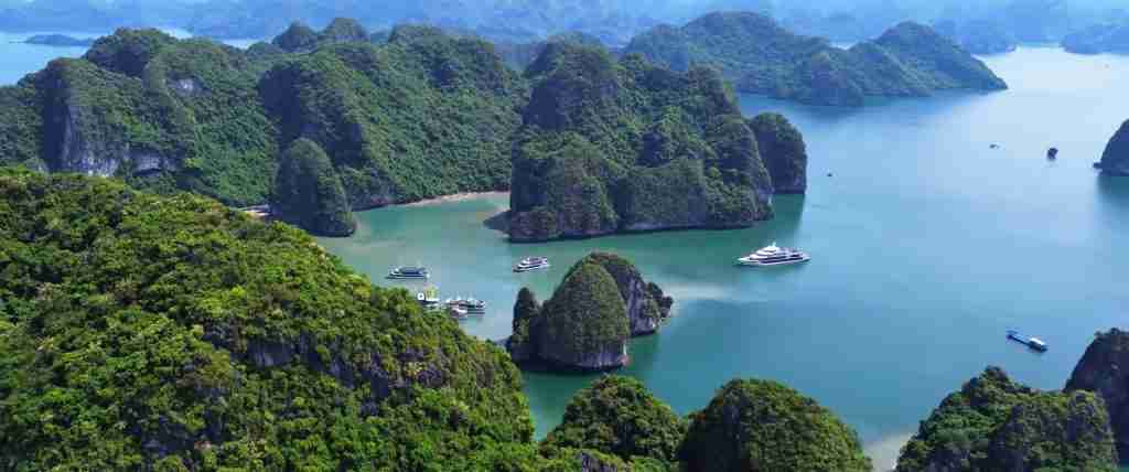
- Marine erosion creates the distinctive undercut bases where waves carved into limestone at water level, creating mushroom-shaped towers with narrow bottoms and wider tops
- Cave systems including Sung Sot (Surprise Cave), Thien Cung (Heavenly Palace Cave), and Dau Go Cave preserve millions of years of geological history through stalactites, stalagmites, and flowstones
- The karst towers rise 50-200 meters above sea level, composed primarily of Ordovician and Silurian period limestone dating 500-400 million years old
- Ongoing erosion processes continue reshaping the karst landscape at rates of millimeters per year, with wave action, rainfall, and vegetation all contributing to formation evolution
Understanding Ha Long Bay’s Geological Architecture
Ha Long Bay represents one of Earth’s most spectacular karst landscapes, where geological processes operating over hundreds of millions of years created a natural architecture of nearly 2,000 limestone towers rising from emerald waters. This UNESCO World Heritage geological wonder demonstrates how rock, water, time, and tectonic forces collaborate to build landscapes rivaling human architectural achievements in drama, beauty, and structural complexity.
The geological story embedded in Ha Long Bay’s karst formations spans from ancient shallow seas depositing limestone sediments 500 million years ago, through tectonic uplifting that raised seabeds into mountains, to millions of years of erosion carving solid limestone into the intricate towers, caves, and channels visible today. Understanding this geological architecture requires examining the rock types, formation processes, erosion patterns, and ongoing changes that created and continue reshaping this extraordinary landscape.
People Also Ask About Ha Long Bay Geological Formations
How did Ha Long Bay’s karst towers form?
Ha Long Bay’s karst towers formed through multi-stage processes spanning 500 million years. Stage one involved limestone accumulation in ancient shallow seas during the Ordovician and Silurian periods (500-400 million years ago) when the area lay beneath tropical oceans. Marine organisms deposited calcium carbonate sediments that compressed into limestone rock layers hundreds of meters thick. Stage two occurred when tectonic forces uplifted the seabed into mountains, raising limestone above water. Stage three began when erosion attacked the uplifted limestone, with rainwater dissolving rock through chemical weathering, creating an initial karst landscape. Stage four occurred when rising sea levels flooded the lower portions of the eroded karst terrain, creating today’s seascape of towers surrounded by water. Marine wave action then carved distinctive undercut bases, creating the mushroom-shaped profile characteristic of Ha Long Bay karsts.
What type of rock are Ha Long Bay’s formations made from?
The karst towers consist primarily of limestone from the Ordovician period (485-444 million years ago) and Silurian period (444-419 million years ago), with some formations containing Devonian limestone (419-359 million years ago). This marine limestone originated as calcium carbonate sediments from ancient sea organisms including corals, shellfish, and microscopic plankton that accumulated on shallow tropical seabeds. The limestone appears gray to white in color, sometimes showing bedding layers visible as horizontal striations in cliff faces revealing the original sedimentary deposition. Some karsts contain fossil remains of ancient marine creatures, providing evidence of their oceanic origins. The rock’s high calcium carbonate content makes it susceptible to chemical weathering by acidic rainwater, the primary erosion mechanism carving karst features over millions of years.
Why do Ha Long Bay karst towers have narrow bases?
The distinctive narrow-base mushroom profile results from differential erosion at different elevations. Wave action concentrates at sea level, creating maximum erosion force precisely at the waterline where waves repeatedly strike limestone surfaces. This constant battering carves horizontal notches into tower bases, undercutting the rock and creating the narrow stems. Above water level, wind-driven spray continues erosion but with less force, while rainfall provides chemical weathering across entire surfaces. Below water, reduced oxygen and different chemical conditions slow erosion. The combined result produces maximum erosion at the waterline, carving deeply undercut bases while leaving wider rock masses above. This process creates structurally precarious-appearing formations where massive rock towers balance on seemingly inadequate stems, though the limestone’s strength prevents collapse under the top-heavy geometry.
Are Ha Long Bay’s karst formations still changing?
The karst landscape continues evolving through ongoing erosion processes operating at geological timescales of millimeters per year. Wave action persistently carves waterline notches deeper into limestone bases, gradually accentuating the mushroom profiles. Rainfall continues chemical dissolution of exposed rock surfaces, slowly reducing tower heights and widening caves. Vegetation growing on karst surfaces contributes to erosion through root action breaking apart rock and organic acids attacking limestone. Storm events accelerate erosion through enhanced wave action and rainfall. Eventually—across thousands to millions of years—current towers will erode completely while new features emerge from ongoing processes. The bay’s appearance remains relatively stable across human lifespans but operates as dynamic system when viewed at geological timescales where today’s dramatic towers represent temporary states in continuous landscape evolution.
Extended multi-day tours – 5+ days
Featured Vietnam Multi-Day Tour Packages

3 days
Vietnam 3-Day Discovery Tour
- ✓ Comprehensive Vietnam experience
- ✓ Expert local guides included
- ✓ All accommodation included
- ✓ Transportation provided
5 days
Vietnam 5-Day Highlights Experience
- ✓ Comprehensive Vietnam experience
- ✓ Expert local guides included
- ✓ All accommodation included
- ✓ Transportation provided
7 days
Vietnam 7-Day Cultural Journey
- ✓ Comprehensive Vietnam experience
- ✓ Expert local guides included
- ✓ All accommodation included
- ✓ Transportation provided

10 days
Vietnam 10-Day Complete Adventure
- ✓ Comprehensive Vietnam experience
- ✓ Expert local guides included
- ✓ All accommodation included
- ✓ Transportation provided
Multi-day tour packages powered by TourRadar. Prices and availability subject to change.
The Limestone Foundation: Ancient Seas and Rock Formation
Paleozoic Seafloor Deposition
Ha Long Bay’s geological story begins 500 million years ago during the Ordovician period when the region lay beneath warm, shallow tropical seas. These ancient oceans teemed with marine life including primitive corals, brachiopods, trilobites, and countless microscopic organisms, all extracting calcium and carbonate ions from seawater to build shells and skeletons. When these organisms died, their calcium carbonate remains settled on the seafloor, accumulating over millions of years into massive sediment deposits hundreds of meters thick.
The Ordovician limestone shows distinctive characteristics including fine grain structure, gray coloration, and occasional fossil preservation. Silurian period deposition continued this process with similar but slightly different marine communities contributing to the limestone accumulation. The combined Ordovician-Silurian limestone sequence reaches 300-500 meters total thickness in some areas, representing tens of millions of years of continuous marine deposition in stable shallow sea environments.
Sedimentary bedding planes visible in many karst cliff faces reveal this depositional history, with horizontal or gently tilted layers showing individual deposition episodes separated by slight composition or grain size differences. Some layers contain concentrated fossil assemblages where particular environmental conditions favored specific marine communities, creating fossil-rich horizons within otherwise uniform limestone. These ancient seabeds provided the raw material that subsequent geological processes transformed into today’s spectacular karst landscape.
Lithification and Rock Formation
The transformation of soft carbonate sediments into hard limestone rock occurred through lithification processes operating over millions of years under increasing burial pressure as new sediment layers accumulated above. Pressure squeezed water from sediments while dissolved minerals precipitated from groundwater, cementing individual grains together into solid rock. Recrystallization processes reorganized original microscopic crystal structures into larger, more stable configurations increasing rock strength.
The limestone’s properties—including strength, erosion resistance, and response to chemical weathering—derive from these lithification processes. Ha Long Bay’s limestone shows excellent strength supporting vertical cliffs and overhangs despite apparent fragility. The rock’s crystalline structure creates natural fracture patterns that influence how erosion carves specific features, with cracks and fissures providing water access into rock interiors enabling cave formation. Understanding lithification clarifies how ancient seafloor muds transformed into rock capable of standing as 200-meter towers despite millions of years of erosive attack.
Tectonic Uplift and Mountain Building
The limestone’s journey from seafloor to aerial landscape required tectonic uplift raising rock layers thousands of meters above their depositional depths. Plate tectonic forces during the Cenozoic era (65 million years ago to present) created compressional stresses that folded and uplifted the limestone formations, transforming horizontal seabed layers into tilted, fractured mountain terrain. This uplift occurred gradually over millions of years as tectonic plates converged, generating the mountain ranges extending across northern Vietnam.
Evidence of tectonic forces appears in tilted limestone beds, fault lines cutting through formations, and the overall structural complexity of the karst terrain. Some karsts show dramatic bedding tilts where originally horizontal layers now stand at steep angles, demonstrating the intense deformation accompanying mountain building. The uplift process created extensive fracture systems throughout the limestone, providing pathways for water infiltration that initiated karst development through dissolution along these structural weaknesses.
Karst Development Processes: Sculpting Stone with Water
Chemical Weathering and Limestone Dissolution
Karst formation depends fundamentally on limestone’s susceptibility to chemical weathering by acidic water. Rainwater absorbs carbon dioxide from the atmosphere, creating weak carbonic acid that reacts with calcium carbonate (limestone’s primary component), dissolving the rock through chemical reaction. This dissolution process operates slowly—typically removing fractions of millimeters per year—but accumulates into dramatic effects across millions of years of continuous action.
The chemical reaction follows a simple equation: limestone plus carbonic acid yields dissolved calcium and bicarbonate ions carried away in solution. This process explains how solid rock transforms into the intricate karst landscape, with water literally dissolving stone and carrying it away molecule by molecule. Higher rainfall increases dissolution rates while tropical temperatures accelerate chemical reactions, making Ha Long Bay’s climate ideal for karst development through optimal combination of precipitation and warmth driving rapid dissolution.
Dissolution acts preferentially along fractures, bedding planes, and other structural weaknesses where water concentrates. This selective erosion creates the bay’s characteristic vertical towers separated by channels and passages where dissolution exploited joint systems cutting through original limestone masses. The tower-and-channel landscape reflects the underlying fracture network pattern, with towers representing less-fractured limestone blocks resisting dissolution while surrounding highly-fractured zones eroded preferentially into water passages.
Fengcong and Fenglin Karst Morphologies
Geologists distinguish two primary karst tower morphologies visible in Ha Long Bay: fengcong (cone karst) and fenglin (tower karst), representing different developmental stages. Fengcong features conical hills with rounded tops and continuous bases, appearing as clusters of cones joined at their bases. This morphology represents earlier karst development stages where dissolution carved valleys between hills but hasn’t yet isolated individual towers. Some Ha Long Bay areas show fengcong characteristics with grouped conical formations sharing continuous bases.
Fenglin morphology represents more advanced karst development where continued erosion isolated individual towers as separate entities surrounded by lowlands or water. Ha Long Bay’s iconic formations exemplify fenglin karst with individual limestone towers rising as discrete units from the bay’s waters. The progression from fengcong to fenglin occurs as erosion deepens valleys between cones, eventually cutting through to bedrock or sea level and isolating formerly-connected cones as independent towers. Ha Long Bay shows this full progression with both morphology types visible in different areas reflecting varied erosion stages.
Marine Transgression and Sea Level Changes
Ha Long Bay’s distinctive seascape resulted from marine transgression—sea level rise flooding the lower portions of a pre-existing terrestrial karst landscape. During ice age periods when global sea levels stood 120+ meters lower than present, the entire Ha Long Bay area formed dry land with karst towers extending upward from river valley floors. Karst development occurred in terrestrial environments with rivers cutting between limestone towers and rainfall driving dissolution processes.
As glaciers melted following the last ice age maximum 20,000 years ago, rising seas gradually flooded the karst valleys, transforming terrestrial karst into marine karst seascape. This flooding created Ha Long Bay’s modern configuration with karst towers rising from water rather than land, fundamentally changing the erosion regime by introducing wave action as major erosional force. The process demonstrates how sea level changes profoundly alter landscapes, with the same karst structures experiencing completely different environmental conditions pre- and post-marine transgression.
Evidence of pre-flooding conditions appears in cave entrances located below current sea level, formed when those elevations sat above water in the terrestrial landscape. Submerged cave passages accessible to divers show stalactites and stalagmites that could only form in air-filled caves, proving these now-underwater features developed before marine flooding. This evidence documents Ha Long Bay’s recent geological history spanning the transition from land to sea over the past 10,000-20,000 years.
Marine Erosion Features: Wave-Carved Architecture
Undercut Bases and Mushroom Profiles
Ha Long Bay’s most distinctive visual feature—karst towers with dramatically undercut bases creating mushroom or top-heavy profiles—results directly from marine wave erosion concentrating at sea level. Waves strike limestone surfaces at the waterline with maximum force, creating mechanical erosion through constant battering plus enhanced chemical erosion from spray keeping rock surfaces continuously wet and exposing fresh rock to chemical attack.
The erosion mechanism operates through multiple processes: direct mechanical impact as waves slam into rock faces, hydraulic pressure forcing water into cracks causing rock breakage, abrasion from suspended sediment particles acting as natural sandblasting agents, and chemical dissolution accelerated by constant wetting. These combined forces carve horizontal notches into tower bases precisely at mean water level, creating the narrow stems characteristic of Ha Long Bay formations.
Notch width and depth reflect local wave energy, rock resistance, and erosion duration. More exposed towers facing dominant wave directions show deeper undercutting than sheltered towers in protected positions. The mushroom geometry creates apparent structural instability where massive rock crowns balance on stems sometimes only meters wide, though limestone’s compressive strength prevents collapse under these top-heavy configurations. Some severely undercut towers will eventually collapse when erosion reduces stem widths below critical structural thresholds, though these collapse events occur across geological rather than human timescales.
Tidal Influence on Erosion Patterns
Tidal ranges of 2-4 meters in Ha Long Bay create vertical erosion zones where alternating submersion and exposure accelerates weathering. The intertidal zone experiences the most aggressive erosion through repeated wet-dry cycles that enhance both mechanical and chemical weathering. Rock surfaces experience maximum stress through temperature fluctuations as sun-heated exposed rock plunges into cooler water during tidal flooding, creating thermal stress that fractures rock surfaces.
Salt crystallization within rock pores provides additional erosion mechanism, with seawater infiltrating porous limestone, evaporating during low tide exposure, and leaving salt crystals that grow within pores, creating internal pressures that fragment rock. This process operates most effectively in the intertidal zone where repeated flooding and drying cycles enable salt accumulation and subsequent crystallization damage. The combined tidal influences create erosion rates in intertidal zones potentially exceeding rates above or below this critical elevation.
Storm Event Impacts
Typhoons and severe tropical storms accelerate marine erosion through enhanced wave action, elevated sea levels, and intense rainfall. Storm waves reach heights of 3-5 meters or more, striking karst bases with enormous force that can remove significant rock volumes in single events. Storm surges raise water levels 1-3 meters above normal, shifting the erosion zone upward and attacking rock surfaces normally above wave reach. Intense rainfall during storms provides maximum chemical dissolution through high water volumes and extended contact times with rock surfaces.
Storm impacts accumulate over time despite infrequent occurrence, with major storms potentially causing more erosion in hours than normal conditions achieve in years. Evidence of storm damage appears in fresh rock falls at tower bases and newly-exposed bright limestone surfaces contrasting with darker weathered rock. The storms’ role in karst evolution demonstrates how episodic extreme events contribute disproportionately to landscape development compared to gradual everyday processes, a pattern recognized across many geological systems.
Cave Systems: Internal Karst Architecture
Cave Formation Mechanisms
Ha Long Bay’s extensive cave systems formed through groundwater dissolution of limestone along fractures, bedding planes, and other structural weaknesses. Cave development began when the karst terrain existed above sea level with water tables fluctuating within the rock mass. Groundwater flowing through fracture networks dissolved surrounding limestone, gradually enlarging pathways from narrow cracks into chambers and passages meters or tens of meters in dimension.
Cave development followed preferential pathways where structural features created easier dissolution routes. Horizontal caves often follow bedding planes where slightly different rock composition or sedimentary breaks provided dissolution targets. Vertical shafts exploit fault lines and joint systems cutting perpendicular to bedding. The resulting cave networks reflect the three-dimensional fracture geometry embedded in the limestone, with cave passages mapping the rock’s internal structural architecture.
Multiple cave formation phases occurred as changing water table levels created different dissolution zones. The most spectacular caves show multiple levels reflecting sequential development at different elevations as tectonic uplift raised the karst terrain, shifting water tables downward and leaving older cave passages dry while new passages formed at lower elevations. This layered cave architecture preserves geological history through the vertical arrangement of passage levels documenting the uplift sequence.
Speleothems: Stalactites, Stalagmites, and Flowstones
Ha Long Bay’s caves contain spectacular speleothem formations—secondary mineral deposits including stalactites, stalagmites, columns, and flowstones—created through water dripping or flowing through air-filled cave passages. The formation process reverses the dissolution that created caves: water infiltrating from above dissolves limestone, becomes saturated with calcium carbonate, then deposits dissolved minerals when reaching cave air, gradually building speleothems through mineral accumulation drop by drop across thousands of years.
Stalactites grow downward from cave ceilings where water drips form cave roofs, leaving behind mineral rings that accumulate into downward-pointing icicle-like structures. Stalagmites grow upward from cave floors where dripping water deposits minerals before evaporating, building upward-pointing conical or cylindrical formations. When stalactites and stalagmites meet, they form columns connecting floor to ceiling. Flowstones develop on cave walls where water sheets across surfaces rather than dripping, depositing minerals as flowing curtains or drapery-like features.
Speleothem growth rates vary from millimeters to centimeters per thousand years depending on water flow rates, mineral concentration, and climate conditions. The size and abundance of Ha Long Bay’s speleothems indicate formation over hundreds of thousands to millions of years, requiring extended periods when caves remained dry and above water tables. The presence of well-developed speleothems in caves now at or near sea level provides additional evidence of tectonic uplift raising formerly-deep caves toward surface elevations.
Major Cave Systems
Sung Sot (Surprise Cave) ranks among Ha Long Bay’s largest and most spectacular caves, featuring two main chambers totaling approximately 10,000 square meters. The cave showcases dramatic stalactite and stalagmite formations, high ceilings reaching 30 meters, and multiple internal chambers demonstrating complex cave network development. Sung Sot’s formation required millions of years of groundwater dissolution followed by extended dry periods allowing speleothem growth.
Thien Cung (Heavenly Palace Cave) features exceptionally colorful speleothems with lighting emphasizing the formations’ natural beauty. The cave’s chambers show evidence of multiple formation phases with older weathered speleothems overlain by younger actively-growing formations. Dau Go Cave (Wooden Stakes Cave) gains historical significance beyond geological interest, reportedly hiding wooden stakes used in 13th century Vietnamese naval victories while demonstrating typical Ha Long Bay cave features including speleothems and multi-level passages.
These major caves represent only the most accessible examples of Ha Long Bay’s extensive cave systems, with many additional caves remaining unexplored or undeveloped for tourism. Submerged caves accessible to technical divers reveal passages that formed during lower sea level periods, extending cave networks below current water surfaces. The total cave length throughout Ha Long Bay’s karst system likely exceeds many kilometers, though much remains undocumented due to access challenges and conservation priorities limiting cave exploration.
Iconic Individual Formations and Their Geology
Fighting Cock Island (Trong Mai Island)
This iconic double-peaked formation resembles two roosters facing each other, creating Ha Long Bay’s most recognizable symbol. Geologically, Fighting Cock Island demonstrates differential erosion where two originally-connected karst masses eroded into separate but adjacent towers. The narrow gap between the “roosters” resulted from enhanced erosion along a vertical fracture zone where water exploited structural weakness, carving through rock and separating the formation into distinct peaks while erosion resistance elsewhere maintained the overall structure.
The formation’s dramatic silhouette against sunset skies makes it photography favorite, though the geological interest lies in how erosion can create seemingly-impossible structures balanced at apparent tipping points. The towers demonstrate limestone’s exceptional strength despite appearing structurally precarious, with internal rock architecture supporting the overhanging masses that defy apparent gravitational logic.
Incense Burner Island (Dinh Huong Island)
This formation’s shape resembles traditional Vietnamese incense burners, with a narrow stem supporting broader upper sections. The geology exemplifies extreme undercutting where marine erosion carved deeply into the tower base while upper portions remained relatively protected from wave action. The formation shows how continued erosion will eventually cause collapse as the stem becomes too narrow to support the crown, though this critical point lies centuries to millennia in the future.
Incense Burner Island demonstrates the progression toward ultimate karst tower destruction through marine erosion. Currently stable, the formation represents a temporary state in the continuum from massive karst block to fragmented remnants, with ongoing erosion gradually reducing structural stability toward eventual collapse. The formation thus captures a moment in deep geological time, preserved temporarily before erosion completes its destructive work.
Other Notable Formations
Stone Dog Island shows erosion-carved shapes resembling animal forms through random weathering patterns that happen to create recognizable silhouettes. These formations demonstrate how human pattern recognition sees familiar forms in random natural features, though the geology remains standard karst erosion without any special processes creating intentional shapes. The formations’ scientific value lies in demonstrating erosion’s ability to create diverse forms from uniform limestone through complex interactions between rock structure, erosion processes, and simple chance.
Ongoing Evolution: The Living Karst Landscape
Contemporary Erosion Rates
Research using precise surveying techniques measures current erosion rates in Ha Long Bay at 0.5-2 millimeters per year on exposed rock surfaces, with higher rates in wave-action zones and lower rates on protected faces. These seemingly insignificant rates accumulate into substantial changes across geological timescales—1 millimeter per year removes 1 meter per million years, potentially reducing a 100-meter tower to sea level over 100 million years assuming constant erosion rates.
Erosion rates vary with rock type, exposure, and local conditions. Dense, crystalline limestone resists erosion better than porous, fractured rock. Towers facing dominant wave directions erode faster than sheltered formations. Protected tower tops experience mainly rainfall dissolution while bases suffer combined wave and chemical attack. This differential erosion creates and maintains the distinctive morphologies characterizing Ha Long Bay’s karst towers.
Climate Change Impacts
Rising sea levels from climate change alter erosion patterns by shifting the wave-action zone upward on tower bases, attacking previously-protected rock surfaces. A 1-meter sea level rise elevates the maximum erosion zone 1 meter, potentially accelerating tower base undercutting. However, the slow erosion rates mean century-scale sea level changes produce minimal visible effects despite measurable impacts at geological timescales.
Changing precipitation patterns influence chemical erosion rates through altered rainfall amounts and intensity. Increased storm frequency and intensity enhance erosion through more frequent extreme wave events. Ocean acidification from increased atmospheric carbon dioxide potentially accelerates limestone dissolution through more aggressive chemical weathering. These climate impacts add to natural geological erosion, though distinguishing climate effects from normal variability remains challenging without multi-century monitoring baselines.
Future Landscape Evolution
Projecting Ha Long Bay’s future requires extrapolating current erosion processes across millions of years. Continued undercutting will eventually cause tower collapses, reducing current formations to lower rubble piles. Some current towers will completely erode away, disappearing from the landscape while others form from continued erosion of larger karst masses. Rising sea levels may submerge lower towers, converting them from islands to submarine features while higher towers persist as islands in deeper waters.
At multi-million year timescales, plate tectonic processes may uplift the region further, potentially raising current sea-level formations above water and exposing currently-submerged features. Alternatively, subsidence could lower the landscape, drowning more towers beneath rising seas. These tectonic possibilities introduce uncertainty into long-term projections beyond simple erosion extrapolations. Regardless of specific paths, the current landscape represents merely one frame in the endless film of geological change, destined for transformation into something fundamentally different across incomprehensible future timeframes.
Frequently Asked Questions About Ha Long Bay Geological Formations
How old are Ha Long Bay’s limestone formations?
The limestone rock itself dates from the Ordovician and Silurian periods, approximately 500-400 million years old, formed from marine sediments in ancient tropical seas. The current karst tower landscape is much younger, developing primarily over the past 20-30 million years through erosion following tectonic uplift. The distinctive seascape with towers surrounded by water formed only in the past 10,000-20,000 years as rising post-ice-age sea levels flooded pre-existing terrestrial karst valleys. Thus the limestone is ancient, the karst landscape is geologically young, and the marine configuration is very recent in geological terms.
Why is Ha Long Bay’s limestone gray instead of white?
Pure calcium carbonate appears white, but Ha Long Bay’s limestone contains impurities including organic matter, iron minerals, and clay particles incorporated during original sediment deposition, creating gray coloration. Weathering processes darken exposed surfaces further through biological growth (lichens, algae), organic staining from vegetation, and iron oxide formation. Fresh rock exposed by recent fracturing or rockfalls shows lighter coloration before weathering darkens surfaces over decades to centuries. The gray color provides geological information about rock composition and weathering history, with color variations across formations reflecting differences in impurity content and exposure history.
Could Ha Long Bay’s karst towers collapse?
Individual towers will eventually collapse as ongoing erosion reduces base dimensions below structural stability thresholds, though these collapses occur across geological rather than human timescales. Some towers show sufficient undercutting to suggest collapse within centuries to millennia given current erosion rates. Sudden collapses from earthquakes, storms, or reaching critical stability limits occur occasionally, though remain rare events. The overall karst landscape persists despite individual tower collapses as new towers continue forming from larger karst masses even as old towers erode away. Visitors face negligible risk from tower collapses given the slow processes and strong rock, though maintaining distance from severely undercut bases represents prudent precaution.
What causes the vegetation growing on karst surfaces?
Hardy plant species colonize limestone surfaces by rooting in cracks, crevices, and soil accumulations in surface depressions. These plants tolerate harsh conditions including limited soil, moisture stress during dry periods, and salt spray exposure. Root systems exploit fractures, obtaining moisture and nutrients from rock weathering and atmospheric deposition. The vegetation plays complex roles in karst development: roots physically break rock through growth pressure, organic acids attack limestone chemically, and plant matter creates soil enabling more extensive vegetation coverage. Vegetation thus accelerates erosion while stabilizing surfaces against certain erosion types, creating complex feedbacks in karst landscape evolution.
Are there fossils in Ha Long Bay’s limestone?
Yes, the marine limestone contains fossils of organisms from Ordovician and Silurian seas including corals, brachiopods, trilobites, and other ancient marine creatures. However, fossils aren’t readily visible in most locations due to weathering and recrystallization processes that obscured original structures. Fresh rock exposures from recent fracturing or quarrying occasionally reveal well-preserved fossils. Cave systems sometimes show fossil assemblages on internal surfaces protected from weather. The presence of marine fossils in karst towers rising 100+ meters above sea level provides dramatic evidence of tectonic uplift raising ancient seabeds to current elevations across millions of years.
Why do some karst towers have caves while others don’t?
Cave presence reflects specific geological conditions including rock fracturing patterns enabling water infiltration, sufficient time under proper water table conditions for dissolution to create substantial voids, and structural stability preventing cave collapse. Heavily-fractured rock develops more extensive cave systems than massive unfractured blocks. Towers that experienced optimal groundwater flow during formation developed larger caves than towers with minimal water circulation. Some towers had caves that subsequently collapsed, leaving no surface evidence of former internal voids. The distribution of caves throughout Ha Long Bay reflects this complex interplay of fracturing, groundwater conditions, and structural stability rather than simple random variation.
How does Ha Long Bay compare geologically to other karst landscapes?
Ha Long Bay exemplifies fenglin tower karst developed in marine setting, sharing characteristics with karst landscapes in southern China (Guilin), Thailand (Phang Nga Bay), and elsewhere in Southeast Asia formed from similar limestone under tropical conditions. Ha Long Bay’s distinctiveness lies in the marine transgression creating seascape rather than terrestrial landscape, the dramatic density of formations creating labyrinthine waterways, and the preservation of both fengcong and fenglin morphologies showing karst evolution stages. While the geological processes remain universal, the specific configuration makes Ha Long Bay among Earth’s most spectacular karst expressions worthy of UNESCO World Heritage geological designation.
What role did ice ages play in Ha Long Bay’s formation?
Ice ages lowered global sea levels by locking water in continental glaciers, exposing Ha Long Bay area as dry land with karst towers rising from river valley floors. During these periods, karst development occurred in terrestrial conditions with rivers cutting between towers and rainfall driving dissolution. Post-ice age warming melted glaciers, raising seas and flooding the karst valleys to create today’s marine seascape. This sea level fluctuation fundamentally transformed the landscape from terrestrial to marine environment, introducing wave erosion and creating the distinctive seascape visible today. Ice age cycles over the past 2-3 million years repeatedly shifted Ha Long Bay between terrestrial and marine conditions.
Can earthquakes damage Ha Long Bay’s karst towers?
Northern Vietnam experiences low-to-moderate seismic activity, with occasional earthquakes potentially affecting karst structures. Strong ground shaking could trigger rockfalls from unstable tower faces or collapse of severely undercut formations near structural limits. However, the region’s relatively low seismicity means major earthquake damage remains unlikely, with most towers showing sufficient structural stability to withstand regional earthquake intensities. Historical records document no major karst collapses from earthquakes in Ha Long Bay, suggesting current formations maintain adequate strength despite appearing precarious. Ongoing monitoring detects any structural changes threatening stability, though significant earthquake-driven transformation remains improbable given regional seismic conditions.
How do scientists study Ha Long Bay’s geological formations?
Geological research employs multiple techniques including rock sampling for age dating and composition analysis, satellite and aerial imagery for mapping formation distributions, sonar surveys mapping submerged features, cave exploration documenting internal structures, erosion monitoring using precise surveying, and computer modeling simulating formation processes. Researchers extract rock cores from karst formations to examine internal structure and composition. Fossil analysis dates rock layers and reconstructs ancient environments. The combined research reveals Ha Long Bay’s geological history and ongoing evolution, informing conservation management while advancing scientific understanding of karst processes. International research collaborations bring diverse expertise to studying this world-class karst laboratory.
Appreciating Ha Long Bay’s Geological Masterpiece
Ha Long Bay’s geological formations represent natural architecture rivaling humanity’s greatest structural achievements in drama, beauty, and complexity. The 500-million-year story embedded in limestone towers—from tropical seabed origins through mountain-building uplift to patient erosion carving solid rock into intricate karst landscape—demonstrates how our planet builds spectacular scenery through processes operating across incomprehensible timeframes that dwarf human history into insignificance.
Understanding the geological mechanisms behind karst tower formation, cave system development, and ongoing erosion enriches visual appreciation by revealing the deep processes creating surface beauty. The mushroom-shaped towers result from precise erosion patterns concentrating at sea level. The cave systems map internal fracture networks guiding water flow through rock. The overall landscape reflects the underlying geological architecture of fractures, bedding planes, and rock property variations controlling where erosion preferentially attacks versus where rock resists.
Ha Long Bay’s geological significance extends beyond visual spectacle to scientific value as natural laboratory for studying karst processes, marine erosion, cave formation, and landscape evolution. The formations preserve geological history readable through rock layers, fossil assemblages, cave passages, and erosion patterns documenting millions of years of Earth history. UNESCO World Heritage geological designation acknowledges Ha Long Bay as globally significant geological phenomenon deserving protection for its scientific and educational values beyond tourism aesthetics.
The landscape continues evolving through ongoing erosion processes that will eventually destroy current formations while creating new features, making Ha Long Bay’s present configuration temporary in the endless progression of geological change. This awareness of ongoing evolution adds temporal depth to spatial appreciation, recognizing today’s spectacular towers as merely one frame in the geological film that began 500 million years ago and will continue billions of years into the future. We experience Ha Long Bay at a particular moment in its endless transformation, privileged to witness this exceptional karst landscape in its current magnificent state before inevitable change transforms it into something fundamentally different across deep time’s patient progression.