
Ha Long Bay Complete History Guide: UNESCO Heritage Story
Key Takeaways
- Ha Long Bay’s limestone karsts formed over 500 million years through marine regression, creating 1,600 islands and islets across 1,553 square kilometers
- The bay’s name translates to “Descending Dragon Bay,” rooted in Vietnamese legends dating back thousands of years about dragons protecting the Vietnamese people from invaders
- Archaeological evidence reveals human habitation spanning 18,000 years, from prehistoric Soi Nhụ culture through ancient fishing communities to modern settlements
- UNESCO designated Ha Long Bay as a World Heritage Site in 1994 for geological values, expanded in 2000 for biological significance, recognizing its outstanding universal value
- The bay served as a strategic maritime defensive position throughout Vietnamese history, from resistance against Chinese invasions to operations during the French colonial period and Vietnam War
- Traditional fishing communities developed unique floating village cultures over centuries, creating distinctive architectural and social systems adapted to marine life
Introduction: Vietnam’s Timeless Natural Wonder
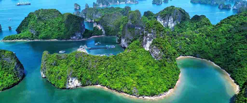
Ha Long Bay stands as one of Southeast Asia’s most spectacular natural wonders, where thousands of limestone islands rise dramatically from emerald waters in northeastern Vietnam. This UNESCO World Heritage Site encompasses an extraordinary geological landscape that took hundreds of millions of years to form, combined with a rich cultural heritage spanning millennia of human civilization. The bay’s towering karst formations, hidden caves, and pristine waters create a landscape that has inspired Vietnamese legends, attracted explorers, and captivated visitors throughout recorded history.
The significance of Ha Long Bay extends far beyond its visual beauty. This natural monument represents a complete geological archive of Earth’s marine regression periods, preserves evidence of ancient human cultures, and documents the evolution of traditional maritime communities. Understanding Ha Long Bay’s complete history reveals how natural forces, human civilizations, and cultural traditions intertwined to create one of the world’s most remarkable heritage sites. The bay’s story encompasses geological epochs, archaeological discoveries, historical conflicts, cultural developments, and conservation efforts that continue to shape its present and future.
People Also Ask About Ha Long Bay History
How old is Ha Long Bay and when did it form?
Ha Long Bay’s geological formation began approximately 500 million years ago during the Cambrian period when the entire region existed as part of a shallow tropical sea. The limestone karsts that define the bay today originated from calcium carbonate deposits accumulated from marine organisms over millions of years. The distinctive tower karst formations emerged through a complex geological process involving multiple marine regression cycles, tectonic uplifts, and erosional forces that sculpted the limestone into the dramatic landscapes visible today.
The most significant formation period occurred between 280-250 million years ago during the Permian era, when thick limestone layers developed in warm, shallow seas. Subsequent tectonic activity during the Triassic period lifted these marine sediments above sea level. The final shaping of Ha Long Bay’s current landscape occurred during the Quaternary period within the last 2 million years, as sea level fluctuations alternately exposed and submerged the karst formations. The modern bay configuration, with its characteristic scattered islands, stabilized approximately 8,000-10,000 years ago as sea levels rose following the last ice age.
What does Ha Long Bay mean in Vietnamese culture?
Ha Long Bay translates literally to “Descending Dragon Bay” in Vietnamese, deriving from the legend that explains the bay’s creation through divine intervention. According to Vietnamese cultural tradition, when the Vietnamese people faced invasion from northern enemies in ancient times, the Jade Emperor sent a family of dragons to defend the land. The mother dragon descended to Ha Long Bay, while her children flew to nearby Bai Tu Long Bay. The dragons spat out jade and jewels that transformed into the thousands of limestone islands and karsts, creating an impenetrable maze that trapped invading ships and protected Vietnamese territory.
This founding legend holds deep cultural significance beyond its narrative value. The dragon represents power, nobility, and divine protection in Vietnamese cosmology, making Ha Long Bay a sacred landscape embodying national identity and cultural pride. The legend reinforces values of familial unity, divine assistance in times of need, and the connection between natural wonders and cultural heritage. Vietnamese people view Ha Long Bay as a gift from celestial dragons, transforming the geological formations into symbols of national resilience and spiritual protection. This cultural interpretation has influenced art, literature, and national consciousness for centuries, making Ha Long Bay central to Vietnamese cultural identity.
Who first discovered and documented Ha Long Bay?
Archaeological evidence indicates that prehistoric humans inhabited Ha Long Bay regions as early as 18,000 years ago, making the bay’s “discovery” a matter of ancient settlement rather than later exploration. The Soi Nhụ culture, dating to approximately 16,000-5,000 BCE, left extensive evidence of human habitation on several bay islands, including stone tools, shell middens, and primitive dwelling structures. These prehistoric communities developed maritime subsistence strategies, harvesting shellfish and fishing in the bay’s rich waters long before recorded history.
Written documentation of Ha Long Bay appears in Vietnamese historical records from the 10th century CE, during the Đinh Dynasty, when the region served as a maritime defensive position. Chinese historical texts from the Han Dynasty period (206 BCE – 220 CE) contain references to the region’s distinctive karst landscape, indicating awareness of the bay’s geographic significance in ancient times. French explorers and naturalists produced the first Western scientific documentation during the late 19th century colonial period, with detailed geological and geographical surveys appearing between 1880-1920. However, Vietnamese fishing communities maintained continuous cultural knowledge of the bay throughout these millennia, preserving oral histories and traditional practices that predated formal documentation.
What major historical events occurred at Ha Long Bay?
Ha Long Bay witnessed numerous pivotal historical events throughout Vietnamese history, serving repeatedly as a strategic maritime location during conflicts and invasions. In 1288, General Trần Hưng Đạo used Ha Long Bay’s complex geography to orchestrate the famous Battle of Bạch Đằng River, where Vietnamese forces defeated a Mongol invasion fleet. The Vietnamese military planted steel-tipped wooden stakes in the riverbed during low tide, luring Mongol ships into the trap during high tide. When the tide receded, the fleet became impaled on the stakes, resulting in one of history’s most celebrated Vietnamese military victories.
During the French colonial period (1883-1954), Ha Long Bay served as an important maritime trade route and coal mining center, with the nearby city of Halong developing as a port facility. The bay’s strategic value continued during the First Indochina War, when Viet Minh forces used the karst islands as hiding places and staging areas for operations against French naval forces. Throughout the Vietnam War (1955-1975), the bay’s waters witnessed naval operations, with several islands serving as lookout posts and defensive positions. In the post-war period, the Vietnamese government recognized the bay’s international significance, leading to UNESCO World Heritage designation in 1994 and subsequent conservation efforts that transformed Ha Long Bay from a military strategic point to a globally protected natural wonder.
Extended multi-day tours – 5+ days
Featured Vietnam Multi-Day Tour Packages

3 days
Vietnam 3-Day Discovery Tour
- ✓ Comprehensive Vietnam experience
- ✓ Expert local guides included
- ✓ All accommodation included
- ✓ Transportation provided

5 days
Vietnam 5-Day Highlights Experience
- ✓ Comprehensive Vietnam experience
- ✓ Expert local guides included
- ✓ All accommodation included
- ✓ Transportation provided

7 days
Vietnam 7-Day Cultural Journey
- ✓ Comprehensive Vietnam experience
- ✓ Expert local guides included
- ✓ All accommodation included
- ✓ Transportation provided
10 days
Vietnam 10-Day Complete Adventure
- ✓ Comprehensive Vietnam experience
- ✓ Expert local guides included
- ✓ All accommodation included
- ✓ Transportation provided
Multi-day tour packages powered by TourRadar. Prices and availability subject to change.
Geological Formation: 500 Million Years in the Making
The Cambrian Origins and Marine Deposits
Ha Long Bay’s geological story begins in the Cambrian period approximately 500 million years ago, when the region existed beneath a warm, shallow tropical sea. During this ancient epoch, marine organisms including trilobites, brachiopods, and early mollusks thrived in these waters, their calcium carbonate shells and skeletons accumulating on the seafloor in massive quantities. Over millions of years, these biological deposits compressed under tremendous pressure, forming the thick limestone beds that now constitute Ha Long Bay’s karst formations. The limestone layers reached depths of several thousand meters in some locations, creating the raw material for the future landscape.
The Ordovician and Silurian periods (485-419 million years ago) continued this process of marine sedimentation, with periodic tectonic shifts causing localized variations in water depth and sediment characteristics. These variations created distinct limestone strata visible today in cliff faces throughout the bay, each layer representing a specific geological epoch with unique fossil assemblages. The limestone formations contain extensive fossil records documenting marine life evolution across hundreds of millions of years, making Ha Long Bay a valuable geological archive for understanding ancient ocean ecosystems. Geologists identify specific formations including the Cat Ba Formation, Cai Trao Formation, and Man Ve Formation, each corresponding to distinct periods of marine deposition.
Permian Era and Limestone Consolidation
The most significant limestone formation period occurred during the Permian era, approximately 280-250 million years ago, when the region experienced optimal conditions for massive calcium carbonate deposition. Warm tropical waters, abundant marine life, and stable tectonic conditions allowed thick limestone beds to accumulate at unprecedented rates. The Permian limestone layers, often called “Mạ Yên Formation” in geological terminology, reach thicknesses of 800-1,000 meters in some areas of Ha Long Bay, forming the primary substance of the bay’s most impressive karst towers.
During this period, coral reefs flourished throughout the ancient sea, their calcium carbonate skeletons contributing substantially to limestone formation. Fossilized corals, brachiopods, fusulinids, and crinoids appear abundantly in Permian-era limestone throughout Ha Long Bay, providing scientists with detailed records of Paleozoic marine ecosystems. The Permian period ended with the most severe mass extinction event in Earth’s history, the Permian-Triassic extinction approximately 252 million years ago, which dramatically altered marine life but left the massive limestone deposits intact. These consolidated limestone beds would remain underwater for millions more years before tectonic forces began lifting them toward their eventual emergence.
Tectonic Uplift and Karst Formation
Major tectonic activity during the Triassic period (252-201 million years ago) initiated the uplift process that eventually brought Ha Long Bay’s limestone above sea level. The collision of tectonic plates along Southeast Asia’s margins created compressional forces that folded and uplifted marine sediments, transforming horizontal seafloor deposits into elevated terrestrial formations. This uplift occurred gradually over tens of millions of years, with different regions rising at varying rates, creating the complex topography that characterizes northern Vietnam’s limestone landscape today.
Once exposed to atmospheric conditions, the limestone began experiencing karst weathering processes that would ultimately create Ha Long Bay’s distinctive tower formations. Slightly acidic rainwater, containing dissolved carbon dioxide, slowly dissolved the limestone along fractures, joints, and bedding planes. Underground water flow carved extensive cave systems, with some caverns reaching cathedral-like dimensions. The combination of chemical dissolution, mechanical erosion, and structural collapse sculpted the massive limestone blocks into the isolated towers and pinnacles that define Ha Long Bay’s visual character. This karst development process continues today, with limestone dissolution proceeding at rates of approximately 0.1-0.5 millimeters per year.
Quaternary Sea Level Changes and Modern Bay Formation
The final shaping of Ha Long Bay’s current configuration occurred during the Quaternary period within the last 2 million years, as glacial-interglacial cycles caused dramatic sea level fluctuations. During glacial maxima, when vast ice sheets locked up ocean water, sea levels dropped 100-150 meters below current levels, fully exposing Ha Long Bay’s karst formations as a terrestrial landscape. Rivers carved valleys between the limestone towers, creating the drainage patterns still visible in submarine topography. Ancient human inhabitants walked across what is now open water, occupying caves in the limestone cliffs during these low-sea-level periods.
The most recent significant sea level rise began approximately 18,000 years ago as the last ice age ended, with ocean waters gradually flooding the valleys between karst towers. By 8,000-10,000 years ago, sea levels approached modern positions, transforming the terrestrial karst landscape into the marine bay environment visible today. The flooded valleys became navigation channels between islands, while the limestone towers emerged as the 1,600+ islands and islets that characterize Ha Long Bay. This geologically recent submergence explains why many limestone formations rise abruptly from relatively shallow waters, their bases still shaped by ancient terrestrial erosion processes. The bay continues evolving today through ongoing karst weathering, marine erosion, and minor sea level adjustments, ensuring that Ha Long Bay remains a dynamic geological landscape.
Archaeological Heritage: Evidence of Ancient Human Occupation
Prehistoric Cultures and the Soi Nhụ People
Archaeological research reveals that Ha Long Bay supported human habitation for at least 18,000 years, with the earliest evidence found in limestone caves on several bay islands. The Soi Nhụ culture, named after a cave site on Cát Bà Island, represents the oldest documented human presence in Ha Long Bay, dating to approximately 16,000-5,000 BCE. These prehistoric people lived in coastal caves, developed sophisticated stone tool technologies, and exploited the bay’s rich marine resources. Excavations at Soi Nhụ Cave revealed extensive shell middens, stone implements, bone tools, and evidence of fire use, indicating semi-permanent settlement and complex subsistence strategies.
The Soi Nhụ people manufactured specialized tools adapted to maritime environments, including stone knives for processing fish, bone fishhooks, shell scrapers, and stone axes for woodworking. Their diet consisted primarily of shellfish, fish, and marine mammals, supplemented by terrestrial game and plant foods from inland areas. The massive shell middens left by these communities, some reaching depths of several meters, provide archaeologists with detailed records of ancient marine ecosystems and prehistoric subsistence patterns. Radiocarbon dating indicates continuous or repeated occupation of several cave sites spanning thousands of years, suggesting that Ha Long Bay offered reliable resources that supported stable human populations throughout the Pleistocene and early Holocene periods.
Neolithic Maritime Adaptations
As sea levels stabilized in the mid-Holocene period around 6,000-4,000 BCE, Ha Long Bay’s Neolithic inhabitants developed increasingly sophisticated maritime technologies and cultural practices. Archaeological sites from this period show evidence of advanced boat construction, specialized fishing equipment, and the beginning of maritime trade networks. The Cái Bèo culture, dating to approximately 5,000-3,000 BCE, represents a transitional period when Ha Long Bay communities began developing distinctive maritime-adapted cultural traditions that would influence the region for millennia.
Neolithic sites reveal a broader toolkit including polished stone axes, pottery vessels, bone needles for making fishing nets, and shell ornaments indicating social complexity and trade. These communities constructed more permanent settlements on coastal platforms and developed specialized fishing techniques adapted to Ha Long Bay’s unique karst geography. The abundance of fish bones, shellfish remains, and marine mammal bones in archaeological deposits demonstrates comprehensive exploitation of marine resources. Some sites contain evidence of early aquaculture practices, with artificially maintained shellfish beds suggesting deliberate resource management. The Neolithic period established subsistence patterns and cultural traditions that persisted in Ha Long Bay fishing communities into historical times, creating continuity between prehistoric and modern maritime cultures.
Bronze Age and Early Historic Settlements
During the Bronze Age (approximately 1,000-500 BCE), Ha Long Bay became increasingly integrated into broader regional trade networks connecting northern Vietnam with southern China and maritime Southeast Asia. Archaeological evidence indicates that bay communities participated in the Đông Sơn culture, the dominant Bronze Age civilization of northern Vietnam, known for its distinctive bronze drums and advanced metallurgical technologies. Several Ha Long Bay sites contain Đông Sơn artifacts, including bronze tools, weapons, and pottery, indicating cultural connections with mainland populations while maintaining distinctive maritime identities.
The transition to historic periods brought increased political organization and integration into Vietnamese state systems. By the first millennium CE, Ha Long Bay supported permanent fishing villages, served as a maritime trade route, and functioned as a defensive frontier. Chinese historical texts from the Han Dynasty period mention the region’s distinctive geography, indicating awareness of Ha Long Bay’s strategic importance. Archaeological surveys identify numerous historic period sites including fishing village remains, pottery kilns, and evidence of small-scale agriculture on larger islands. These archaeological records document a continuous human presence in Ha Long Bay from prehistoric times through the present, demonstrating the bay’s enduring significance as a habitable and productive maritime environment.
Historical Military Significance: Battles and Strategic Defense
The Battle of Bạch Đằng River (1288)
Ha Long Bay achieved legendary status in Vietnamese military history through the Battle of Bạch Đằng River in 1288, where General Trần Hưng Đạo orchestrated one of history’s most celebrated military victories against Mongol invasion forces. The Mongol Empire, having conquered much of Asia, launched its third invasion attempt against Đại Việt (Vietnam) under the command of Toghan, son of Kublai Khan. The Vietnamese military, vastly outnumbered and outgunned, relied on intimate knowledge of Ha Long Bay’s tidal patterns and geographic complexity to devise a brilliant defensive strategy.
General Trần Hưng Đạo ordered his forces to plant thousands of steel-tipped wooden stakes in the Bạch Đằng River estuary, which flows into Ha Long Bay, positioning them to remain submerged during high tide but exposed during low tide. Vietnamese naval forces engaged the Mongol fleet during high tide, drawing the enemy ships deep into the river system through feigned retreat. As the tide ebbed, the Mongol vessels became impaled on the concealed stakes, rendering them immobile and vulnerable. Vietnamese forces then counterattacked with fire ships and close combat, destroying the Mongol fleet and capturing its commander. This devastating defeat ended Mongol expansion into Southeast Asia and secured Vietnamese independence, demonstrating how local geographic knowledge could overcome superior military force.
Maritime Defense Through Vietnamese Dynasties
Throughout subsequent Vietnamese dynasties, Ha Long Bay maintained strategic importance as a maritime defensive frontier and naval base. The Later Lê Dynasty (1428-1788) established naval stations on several bay islands, using the karst geography as natural fortifications and observation posts. The complex channels between islands provided defensible positions where smaller Vietnamese vessels could outmaneuver larger enemy ships. Historical records document numerous smaller naval engagements and piracy conflicts in Ha Long Bay waters, as Vietnamese authorities worked to maintain control over this vital maritime region.
The bay’s strategic value extended beyond military defense to include maritime trade control and resource extraction. Vietnamese rulers established customs stations and port facilities to monitor and tax maritime commerce passing through the bay. The region’s coal deposits, discovered and exploited during the medieval period, became economically significant, with small-scale mining operations developing on several islands. Military garrisons protected these economic interests while maintaining defensive capabilities against potential seaborne invasions. This combination of military, commercial, and resource extraction functions made Ha Long Bay a consistently important region throughout Vietnamese history, with central governments investing in infrastructure and administrative presence.
Colonial Period and Modern Conflicts
French colonization of Vietnam (1883-1954) transformed Ha Long Bay’s strategic significance, as European powers sought to exploit the region’s coal deposits and develop port facilities. The French established the city of Halong (then called Along) as a colonial administrative center and coal mining hub, constructing railways, port infrastructure, and worker housing. During the First Indochina War, Ha Long Bay became contested territory as Viet Minh forces challenged French control. The karst islands provided hiding places, supply caches, and staging areas for resistance operations, with the complex geography limiting French naval effectiveness.
During the Vietnam War (1955-1975), Ha Long Bay’s proximity to Haiphong Harbor and its role as a maritime approach to northern Vietnam gave it continued strategic importance. North Vietnamese forces established defensive positions on several islands, installing observation posts and anti-aircraft batteries to protect against American naval operations. The bay’s waters witnessed numerous small-scale engagements, mine-laying operations, and naval patrols. Following reunification in 1975, the Vietnamese government maintained a military presence in the bay while gradually transitioning toward economic development and tourism. The end of conflict allowed scientific research and conservation efforts to begin, ultimately leading to UNESCO recognition and the bay’s transformation from military strategic asset to protected natural heritage site.
Cultural Evolution: Fishing Villages and Maritime Traditions
Development of Floating Village Communities
Ha Long Bay’s distinctive floating villages represent centuries of cultural adaptation to maritime life, with fishing communities developing unique architectural, social, and economic systems. These floating settlements emerged gradually as fishing families found permanent residence on the water more practical than mainland living. The villages consist of floating houses constructed on bamboo rafts or empty oil drums, creating buoyant platforms that rise and fall with tides. Traditional construction uses bamboo, wood, and palm thatch for walls and roofing, with modern villages increasingly incorporating corrugated metal and plastic materials.
The four main floating villages in Ha Long Bay—Cửa Vạn, Ba Hang, Cống Đỏ, and Vông Viêng—each developed distinctive characteristics based on their specific locations and founding histories. Cửa Vạn, the largest and oldest, houses approximately 300 families who maintain traditional fishing practices passed down through generations. These communities created complete social systems on the water, including schools, temples, markets, and healthcare facilities, all constructed on floating platforms. The social organization of floating villages revolves around extended family networks, with multiple generations often living in adjacent floating houses, maintaining close-knit community bonds essential for mutual support in the challenging maritime environment.
Traditional Fishing Practices and Maritime Knowledge
Ha Long Bay’s fishing communities developed sophisticated ecological knowledge and specialized techniques adapted to the bay’s unique karst environment. Traditional fishers possess intimate knowledge of tidal patterns, seasonal fish migrations, weather prediction, and underwater topography, information transmitted orally across generations. Fishing methods include various net types adapted to different species and locations: fixed gill nets for channel fishing, cast nets for shallow areas, and specialized squid lights for night fishing. Pearl diving and shellfish harvesting, practiced for centuries, required skilled free-diving techniques and knowledge of productive locations.
The seasonal rhythm of Ha Long Bay fishing follows natural cycles of fish abundance and weather patterns. The main fishing season runs from March through September when calm weather and abundant fish stocks provide optimal conditions. During the northeast monsoon season (October-February), rough seas limit fishing activities, and many families engage in boat maintenance, net repair, and secondary economic activities. Traditional knowledge includes recognizing specific karst formations as navigation landmarks, understanding how tides and currents flow through channels, and predicting weather changes from cloud formations and wind patterns. This ecological wisdom represents centuries of accumulated experience, making fishing families the true experts on Ha Long Bay’s marine environment.
Cultural Traditions and Community Life
Floating village culture developed distinctive traditions, celebrations, and religious practices adapted to maritime life. Most families maintain small altars honoring ancestors and sea spirits, performing regular offerings to ensure safety and abundant catches. The annual Cửa Ông Temple Festival, held on the bay’s coast, attracts fishing families from throughout the region for religious ceremonies honoring maritime deities. Traditional weddings, funerals, and lifecycle celebrations occur on floating platforms, with entire communities participating in elaborate multi-day ceremonies that strengthen social bonds.
Children in floating villages traditionally learned fishing skills from early ages, accompanying parents on boats and gradually mastering complex techniques. Education presented challenges in floating communities, with formal schooling limited until recent government programs established floating schools and provided transportation to mainland educational facilities. The communities developed entertainment traditions including ca trù (ceremonial singing), water puppet performances adapted for floating stages, and storytelling sessions recounting historical events and local legends. These cultural practices maintained community cohesion and transmitted traditional knowledge, creating distinctive maritime cultures that flourish even as modern influences increasingly affect village life.
UNESCO Recognition and Heritage Designation
Path to World Heritage Status
Ha Long Bay’s journey to UNESCO World Heritage designation began with growing international recognition of its geological and scenic values during the 1980s. Vietnamese scientists, particularly geologists and marine biologists, conducted comprehensive research documenting the bay’s outstanding geological features, biodiversity, and cultural significance. These studies provided the scientific foundation for Vietnam’s nomination to UNESCO, emphasizing Ha Long Bay’s exceptional karst landscape, fossil records, and ecological importance. The Vietnamese government established preliminary protection measures, including tourism regulations and fishing restrictions, demonstrating commitment to conservation before submitting the formal nomination.
In December 1994, UNESCO’s World Heritage Committee inscribed Ha Long Bay on the World Heritage List, recognizing its outstanding universal value under geological criteria. The initial designation acknowledged the bay’s spectacular limestone karst landscape, representing the most extensive and best-preserved example of maritime karst formations in the world. The committee emphasized Ha Long Bay’s role as a geological archive documenting marine regression events and karst evolution over millions of years. This recognition brought international attention and established formal protection obligations under the World Heritage Convention.
Expansion and Enhanced Recognition
In November 2000, UNESCO expanded Ha Long Bay’s World Heritage designation to include biological and ecological criteria, acknowledging the bay’s exceptional marine biodiversity and ecosystem values. This enhancement recognized Ha Long Bay’s importance as a habitat for numerous rare and endemic species, including the endangered golden-headed langur, several endemic fish species, and diverse coral communities. The expanded designation increased the protected area and strengthened conservation requirements, reflecting growing understanding of Ha Long Bay’s ecological significance beyond its geological features.
The 2000 expansion required Vietnam to demonstrate enhanced conservation efforts, sustainable tourism management, and protection of both natural and cultural values. The Vietnamese government responded by establishing more comprehensive management plans, creating buffer zones, implementing stricter environmental regulations, and developing sustainable tourism frameworks. These measures aimed to balance economic development through tourism with long-term heritage preservation, a challenge that continues to require careful management and international cooperation. The dual designation under both geological and biological criteria places Ha Long Bay among a select group of World Heritage sites recognized for multiple types of outstanding universal value.
Ongoing Conservation Challenges and Efforts
UNESCO recognition brought increased tourism and economic development, creating both opportunities and challenges for Ha Long Bay’s long-term preservation. The number of visitors increased dramatically from approximately 100,000 annually in the mid-1990s to over 6 million in recent years, placing significant pressure on the bay’s environment and infrastructure. Issues including water pollution from tour boats, waste management, coral damage from anchoring, and overfishing required comprehensive management responses. The Vietnamese government and UNESCO worked collaboratively to develop sustainable tourism strategies balancing economic benefits with environmental protection.
Recent conservation initiatives include limiting the number of cruise boats, establishing waste management systems, creating marine protected areas, relocating some floating village residents to shore-based housing, and implementing visitor education programs. Scientific monitoring programs track water quality, coral health, wildlife populations, and geological stability, providing data for adaptive management strategies. International partnerships with conservation organizations, research institutions, and tourism companies contribute expertise and resources to preservation efforts. These ongoing initiatives reflect the complex challenge of managing a World Heritage site that must serve multiple purposes: protecting natural and cultural values, supporting local communities, generating economic benefits, and providing educational and recreational opportunities for millions of visitors. Success requires continuous adaptation, stakeholder cooperation, and commitment to long-term sustainability over short-term gains.
Modern Era: Tourism Development and Economic Transformation
Emergence of Tourism Industry
Ha Long Bay’s transformation into a major tourism destination began gradually after the Vietnam War, accelerating significantly following economic reforms in the 1980s. Initial tourism development focused on domestic visitors, with basic boat services and limited accommodation options. International tourism expanded rapidly after UNESCO designation in 1994, as Ha Long Bay gained global recognition as a must-visit destination. The Vietnamese government designated tourism development as a national priority, investing in transportation infrastructure, port facilities, cruise boat fleets, and supporting services.
The tourism industry evolved from simple day trips on small boats to sophisticated multi-day cruise experiences on luxury vessels. Modern Ha Long Bay tourism offers diverse options from budget day tours to high-end three-day luxury cruises with gourmet dining, spa services, and cultural programming. The industry created thousands of employment opportunities for local communities, transforming the regional economy from subsistence fishing to service-based tourism. Hotels, restaurants, tour operators, and supporting businesses proliferated in Ha Long City and surrounding areas, fundamentally changing the economic landscape. This economic transformation brought prosperity to the region while also creating challenges related to environmental management, cultural preservation, and sustainable development.
Impact on Traditional Communities
Tourism development profoundly affected Ha Long Bay’s traditional floating village communities, bringing both economic opportunities and cultural disruptions. Many fishing families supplemented or replaced fishing income with tourism-related activities, offering homestays, selling handicrafts, performing cultural demonstrations, or working in the tourism industry. Some families voluntarily relocated to shore-based housing, attracted by modern amenities, educational opportunities, and tourism employment. Government resettlement programs encouraged floating village residents to move to new coastal communities, providing housing and alternative livelihoods while reducing environmental pressure on the bay.
These changes created complex social dynamics within traditional communities. Older generations often maintained attachment to maritime lifestyles and cultural traditions, while younger people increasingly pursued education and careers in the tourism sector or urban areas. Traditional fishing knowledge, boat-building skills, and cultural practices faced potential erosion as fewer young people entered fishing professions. However, tourism also created new value for cultural heritage, with traditional practices, cuisine, and knowledge becoming marketable attractions. Some families successfully balanced tradition and modernity, maintaining fishing activities while participating in tourism through cultural performances, fishing demonstrations, and authentic experiences for visitors. This ongoing negotiation between preservation and development continues to shape floating village communities and their role in Ha Long Bay’s future.
Economic Significance and Regional Development
Ha Long Bay currently generates substantial economic value for Quảng Ninh Province and Vietnam as a whole, with tourism revenue supporting broad regional development. The bay attracts over 6 million visitors annually, generating hundreds of millions of dollars in direct tourism revenue and supporting extensive indirect economic activity. The cruise boat industry alone employs thousands of workers, while hotels, restaurants, transportation services, and supporting businesses create a complex tourism economy. Tax revenues from tourism fund infrastructure improvements, education, healthcare, and environmental conservation programs throughout the province.
Regional development extended beyond tourism to include industrial expansion, particularly coal mining and port operations, which sometimes created conflicts with heritage conservation goals. The Vietnamese government worked to balance economic diversification with environmental protection, investing in pollution control, industrial zoning, and sustainable development initiatives. Ha Long City transformed from a small port town into a modern urban center with improved transportation links, educational institutions, healthcare facilities, and cultural amenities. This development reflected Vietnam’s broader economic growth and urbanization trends, with Ha Long Bay serving as both an economic engine and a conservation challenge requiring careful management to ensure long-term sustainability and heritage preservation.
Scientific Research and Geological Understanding
Karst Geomorphology Studies
Scientific research in Ha Long Bay has significantly advanced understanding of karst geomorphology, marine geology, and landscape evolution processes. Vietnamese and international researchers conducted comprehensive geological surveys documenting the bay’s limestone formations, cave systems, fossil assemblages, and erosion patterns. Studies established detailed chronologies of karst development, identifying specific formation processes including chemical dissolution, mechanical erosion, underground drainage systems, and structural collapse. Research revealed that Ha Long Bay’s karsts exhibit exceptional completeness, preserving evidence of formation stages from initial limestone deposition through current weathering processes.
Geomorphological research identified several distinct karst types in Ha Long Bay, including fengcong karsts (clustered cone karsts), fenglin karsts (tower karsts), and unique maritime formations found nowhere else on Earth. Scientists documented how marine erosion creates distinctive features including notches, tidal caves, coastal platforms, and unusual weathering patterns impossible in terrestrial karst environments. These studies contributed to global karst science, providing data on how marine processes modify limestone landscapes and creating models for understanding similar formations worldwide. Ongoing research monitors current karst development rates, documenting how natural processes and human activities affect landscape evolution and informing conservation strategies to protect these irreplaceable geological features.
Biodiversity and Ecological Research
Marine biology and ecology research revealed Ha Long Bay’s exceptional biodiversity, documenting hundreds of fish species, coral communities, marine mammals, and endemic organisms. Surveys identified numerous species new to science, including several fish species, invertebrates, and plants found only in Ha Long Bay or surrounding areas. The bay’s complex habitat structure, created by limestone islands, caves, underwater karsts, and varied water depths, supports diverse ecological communities adapted to specific microhabitats. Research demonstrated that Ha Long Bay functions as a biodiversity hotspot within the Gulf of Tonkin, providing critical habitat for juvenile fish, breeding grounds for marine species, and refuge for rare animals including the endangered golden-headed langur.
Ecological studies documented complex relationships between physical environment, marine life, and human activities. Research on coral health, water quality, and fish populations provides data for monitoring ecosystem conditions and detecting environmental problems. Scientists study how tourism, fishing, pollution, and climate change affect marine ecosystems, providing evidence for management decisions and conservation policies. This research established Ha Long Bay’s scientific value beyond its geological features, demonstrating that the bay represents an integrated natural-cultural system requiring holistic management approaches. Ongoing biodiversity monitoring continues to reveal new species and document ecosystem changes, ensuring that management decisions reflect current scientific understanding.
Cultural and Archaeological Investigations
Archaeological research in Ha Long Bay expanded understanding of prehistoric cultures, ancient human adaptations to coastal environments, and the bay’s role in Vietnamese history. Systematic surveys identified dozens of archaeological sites, ranging from prehistoric caves to historic village remains, providing evidence of continuous human occupation spanning millennia. Excavations revealed details of ancient subsistence strategies, tool technologies, trade networks, and cultural practices. Studies of shell middens provided paleoenvironmental data, documenting changes in marine ecosystems and climate conditions over thousands of years.
Cultural research documented traditional knowledge systems, fishing practices, and maritime adaptations in floating village communities. Anthropologists recorded oral histories, traditional navigation techniques, weather prediction methods, and ecological knowledge passed through generations. This research demonstrated that floating village cultures represent valuable intangible heritage complementing Ha Long Bay’s natural values. Studies of traditional boat building, net making, fishing techniques, and cultural ceremonies preserved knowledge threatened by modernization and cultural change. This multidisciplinary research established Ha Long Bay as a site where natural heritage and cultural heritage intertwine, requiring integrated conservation approaches that protect both the physical landscape and the human communities who have shaped and been shaped by this extraordinary environment for thousands of years.
Frequently Asked Questions About Ha Long Bay History
How many islands are in Ha Long Bay?
Ha Long Bay contains approximately 1,600 islands and islets spread across 1,553 square kilometers of water. The exact count varies depending on how small limestone outcrops are classified, with some sources reporting between 1,600-2,000 distinct formations. These islands range from tiny rock pinnacles barely breaking the water surface to substantial landmasses several square kilometers in area with forests, beaches, and caves. Each formation represents a remnant of the ancient karst landscape that was flooded by rising seas approximately 8,000-10,000 years ago.
What civilizations lived in Ha Long Bay before modern times?
Archaeological evidence reveals a succession of prehistoric and historic cultures occupying Ha Long Bay over the past 18,000 years. The earliest inhabitants belonged to the Soi Nhụ culture (approximately 16,000-5,000 BCE), followed by Neolithic maritime cultures including the Cái Bèo people (5,000-3,000 BCE). Bronze Age communities participated in the Đông Sơn culture (1,000-500 BCE), Vietnam’s most advanced pre-historic civilization. From the first millennium CE onward, historic Vietnamese fishing communities maintained continuous occupation, developing the maritime traditions and floating village cultures that persist today. This archaeological sequence demonstrates Ha Long Bay’s importance as a habitable and productive environment throughout human history in Southeast Asia.
Why did UNESCO recognize Ha Long Bay twice?
UNESCO inscribed Ha Long Bay on the World Heritage List in 1994 for its exceptional geological values, recognizing the bay’s outstanding limestone karst landscape and fossil records. In 2000, UNESCO expanded the designation to include biological and ecological criteria, acknowledging Ha Long Bay’s marine biodiversity, endemic species, and ecosystem significance. This dual recognition reflects comprehensive understanding of the bay’s values, encompassing both its 500-million-year geological history and its current biological richness. The expanded designation required enhanced conservation measures and demonstrates Ha Long Bay’s exceptional importance across multiple scientific disciplines.
What role did Ha Long Bay play in Vietnamese military history?
Ha Long Bay served repeatedly as a strategic defensive position throughout Vietnamese history, most famously during the 1288 Battle of Bạch Đằng River when General Trần Hưng Đạo used the bay’s geography to defeat a Mongol invasion fleet. Vietnamese forces planted steel-tipped stakes in tidal waters, luring enemy ships into a trap that resulted in one of history’s most celebrated Vietnamese victories. Throughout subsequent dynasties, the bay functioned as a maritime frontier, naval base, and defensive barrier. During French colonization and the Vietnam War, the bay’s complex geography provided strategic advantages for resistance forces and defensive positions, demonstrating how intimate geographic knowledge could overcome superior military power.
How have floating villages changed over the past century?
Ha Long Bay’s floating villages evolved significantly over the past century, transitioning from subsistence fishing communities to partially tourism-dependent settlements facing modernization pressures. Traditional bamboo raft houses increasingly incorporate modern materials including metal roofing, plastic flotation, and diesel generators. Many families now derive income from tourism through homestays, cultural performances, and handicraft sales rather than solely from fishing. Government resettlement programs encouraged some families to relocate to shore-based housing, reducing floating village populations while providing access to education, healthcare, and modern amenities. Despite these changes, several communities maintain traditional practices and cultural identities while adapting to economic opportunities and regulatory requirements imposed by heritage conservation and tourism management.
What makes Ha Long Bay’s geological formation unique?
Ha Long Bay represents the world’s most extensive and best-preserved example of maritime karst landscape, combining exceptional geological age, formation completeness, and distinctive erosion patterns. The bay’s limestone karsts began forming 500 million years ago and preserve complete records of marine regression cycles, tectonic uplift, and erosion processes spanning geological epochs. Unlike terrestrial karst formations, Ha Long Bay’s towers exhibit unique maritime weathering features including tidal notches, marine platforms, and erosion patterns created by wave action and salt spray. The bay’s submergence timing (approximately 8,000-10,000 years ago) created landscapes impossible to replicate elsewhere, making Ha Long Bay irreplaceable for understanding karst evolution in coastal environments.
Who were the Soi Nhụ people?
The Soi Nhụ people represent the earliest documented human inhabitants of Ha Long Bay, living in coastal caves approximately 16,000-5,000 BCE during the late Pleistocene and early Holocene periods. Archaeological excavations in Soi Nhụ Cave on Cát Bà Island revealed extensive evidence of their maritime-adapted culture, including specialized stone tools, bone fishhooks, shell scrapers, and massive shell middens documenting thousands of years of seafood harvesting. These prehistoric people developed sophisticated strategies for exploiting marine resources, manufacturing specialized fishing equipment, and adapting to coastal environments. Their presence establishes Ha Long Bay’s importance as a productive and habitable landscape long before historical records began.
How did French colonization affect Ha Long Bay?
French colonization (1883-1954) transformed Ha Long Bay from a traditional fishing region into an industrial and military strategic zone. The French developed Ha Long City as a coal mining center, constructing port facilities, railways, and worker housing to exploit the region’s mineral resources. The colonial administration established regulatory systems controlling fishing, maritime trade, and resource extraction. During the First Indochina War, Ha Long Bay became contested territory as Viet Minh forces used the karst islands for resistance operations against French naval power. This colonial period fundamentally altered Ha Long Bay’s economic structure, initiated industrial development, and set precedents for resource exploitation that influenced post-colonial development patterns and created environmental challenges that continue requiring management attention.
What is the legend of the descending dragon?
The legend of the descending dragon explains Ha Long Bay’s creation through divine intervention when Vietnam faced invasion in ancient times. According to tradition, the Jade Emperor sent a family of dragons to defend the Vietnamese people from northern enemies. The mother dragon descended into Ha Long Bay (Descending Dragon Bay), while her children flew to nearby Bai Tu Long Bay (Children of the Dragon Bay). The dragons spat out jade and jewels that transformed into thousands of limestone islands, creating an impenetrable maze that trapped and destroyed invading ships, protecting Vietnamese territory through divine assistance. This founding myth connects natural landscape features with cultural values including divine protection, national independence, and familial unity, making Ha Long Bay central to Vietnamese cultural identity and national consciousness.
How has tourism changed Ha Long Bay since UNESCO designation?
Tourism expanded dramatically following UNESCO World Heritage designation in 1994, transforming Ha Long Bay from a relatively unknown destination to one of Southeast Asia’s most visited natural attractions. Visitor numbers increased from approximately 100,000 annually in the mid-1990s to over 6 million in recent years, driving massive infrastructure development including cruise boat fleets, hotels, restaurants, and supporting services. This growth created substantial economic benefits through employment, business opportunities, and tax revenues, but also generated challenges including water pollution, waste management problems, coral damage, and pressure on traditional communities. The Vietnamese government implemented increasingly sophisticated management systems balancing economic development with heritage conservation, demonstrating the complex challenges of managing popular World Heritage sites that must simultaneously protect natural values while providing public access and economic benefits.