Giant’s Causeway UNESCO World Heritage Guide: Geology & Legends
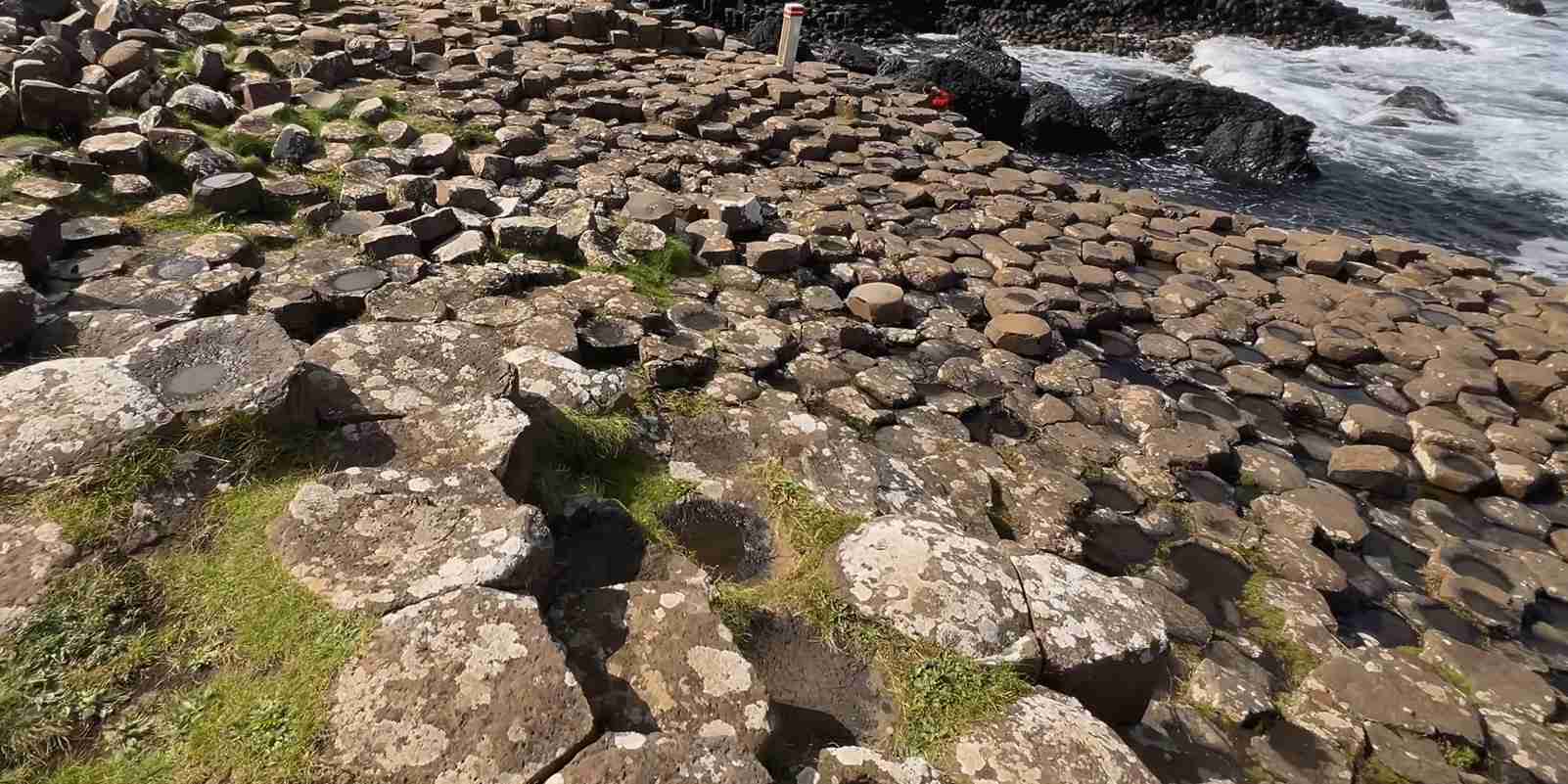
Northern Ireland’s Giant’s Causeway stands as one of Earth’s most extraordinary geological spectacles, where approximately 40,000 interlocking hexagonal basalt columns emerge from the Atlantic coastline like the remnants of a mythical giant’s pathway. This UNESCO World Heritage Site inscribed in 1986 combines superlative natural beauty with profound scientific significance, while ancient Irish legends weave tales of heroic giants across the very stones that geologists have studied for three centuries to unlock secrets of our planet’s volcanic past.
Key Takeaways About Giant’s Causeway
- Dual UNESCO Recognition: Giant’s Causeway and Causeway Coast earned World Heritage status in 1986 under both Criterion VII for exceptional natural phenomena and beauty, and Criterion VIII as an outstanding example of Earth’s geological history during the Palaeogene period.
- Volcanic Time Capsule: The approximately 40,000 basalt columns formed 50-60 million years ago when molten lava cooled and contracted into predominantly hexagonal shapes through a natural geometric process that minimizes stress during crystallization.
- Scientific Milestone: Three centuries of geological studies at Giant’s Causeway contributed fundamentally to the development of earth sciences and volcanology, earning recognition from the International Union of Geological Sciences as one of 100 global geological heritage sites.
- Legendary Landscape: Irish mythology attributes the causeway to the giant Finn MacCool (Fionn mac Cumhaill), who supposedly built this stone pathway to confront his Scottish rival Benandonner, creating one of Ireland’s most enduring folk tales that explains the natural wonder through heroic narrative.
- Transnational Connection: The same volcanic eruptions that created Giant’s Causeway also formed identical basalt columns at Fingal’s Cave on Scotland’s Isle of Staffa, physically connecting the geological story across the North Channel and lending credence to the legend of a giant’s bridge.
- Accessible Natural Monument: Unlike many World Heritage Sites, access to the Giant’s Causeway formations themselves remains free of charge, allowing visitors to walk directly upon these ancient volcanic columns that continue to inspire wonder and scientific inquiry.
People Also Ask About Giant’s Causeway
How Did the Giant’s Causeway Form Geologically?
The Giant’s Causeway formed through a precise volcanic cooling process approximately 50-60 million years ago during the Palaeogene period. Highly fluid molten basalt erupted through fissures in the Earth’s crust, intruding through existing chalk beds and filling river valleys to create a volcanic plateau across what is now the Antrim coast. As this massive lava flow began to cool from the surface downward, thermal contraction created internal stresses within the solidifying rock. To dissipate these enormous stresses most efficiently, the basalt cracked at 120-degree angles, producing the predominantly hexagonal column pattern visible today. The cooling process advanced steadily downward from the exposed surface, propagating vertical fractures through the entire depth of the lava flow and creating columns that extend deep beneath the visible surface. Horizontal fracturing then subdivided these vertical columns into the disc-like segments often described as “biscuits,” completing the remarkable three-dimensional geometry that characterizes the formation.
What Makes the Basalt Columns Hexagonal?
The hexagonal shape of Giant’s Causeway columns results from geometric efficiency during the thermal contraction of cooling lava. When volcanic rock cools and solidifies, it shrinks as molecules rearrange into a crystalline structure, creating internal stress. The most energy-efficient way to relieve this stress is through cracks forming at 120-degree angles to one another, which naturally produces hexagons when three crack systems intersect. Approximately 60 percent of the causeway’s columns exhibit this classic six-sided form, while others display four, five, seven, or eight sides depending on local variations in cooling rates and stress distribution. The hexagonal pattern represents nature’s solution to a complex physics problem: how to subdivide a contracting surface into equal areas with the minimum total crack length, a principle also visible in drying mud, honeycomb construction, and various other natural phenomena.
Who Was Finn MacCool in Irish Mythology?
Finn MacCool, known in Irish as Fionn mac Cumhaill, stands as one of the most celebrated figures in Irish mythology, though his association with giant stature specifically emerged in later folklore rather than ancient texts. In the Fenian Cycle of Irish mythology, Finn appears as a legendary hunter-warrior and leader of the Fianna, a band of warriors serving Irish high kings. Original mythological accounts portray him as a hero with supernatural abilities including wisdom, foresight, and great strength, rather than as a literal giant. The transformation from mythological hero to giant reflects a common folkloric process whereby, as one 19th-century scholar noted, “the pagan gods of Ireland grew smaller and smaller in the popular imagination until they turned into the fairies; the pagan heroes grew bigger and bigger until they turned into the giants.” The Giant’s Causeway legend represents this later evolution, where Finn’s heroic scale translated into physical enormity to explain the massive stone formations along the Antrim coast.
Why Is Giant’s Causeway Connected to Scotland’s Staffa?
The geological connection between Giant’s Causeway and Scotland’s Isle of Staffa stems from the same sequence of volcanic eruptions during the Palaeogene period. The basalt columns at Fingal’s Cave on Staffa were formed by the identical lava flows that created the Giant’s Causeway, part of the extensive North Atlantic Igneous Province that produced volcanic activity across what is now Northern Ireland and western Scotland. This genuine geological link across the North Channel provided the foundation for the Finn MacCool legend, where the mythical causeway supposedly connected Ireland and Scotland as a stone bridge. The similar hexagonal column formations at both locations, created by the same cooling process in the same volcanic episode, made the folk tale of a giant’s pathway remarkably believable to those observing the landscape before modern geological science explained the true connection.
Extended multi-day tours – 5+ days
Featured Northern Ireland Multi-Day Tour Packages
5 days
5 Days in Belfast: Discover Thrones, Titanic & the Causeway
- ✓ Comprehensive Northern Ireland tour
- ✓ Expert local guides included
- ✓ All accommodation arranged
- ✓ Transportation provided
8 days
Celtic Halloween Experience
- ✓ Comprehensive Northern Ireland tour
- ✓ Expert local guides included
- ✓ All accommodation arranged
- ✓ Transportation provided

3 days
Halloween Party in Ireland 3-Day tour
- ✓ Comprehensive Northern Ireland tour
- ✓ Expert local guides included
- ✓ All accommodation arranged
- ✓ Transportation provided
5 days
Walking the Antrim Coast
- ✓ Comprehensive Northern Ireland tour
- ✓ Expert local guides included
- ✓ All accommodation arranged
- ✓ Transportation provided
Multi-day tour packages powered by TourRadar. Prices and availability subject to change.
Introduction: Where Geology and Legend Converge
The Giant’s Causeway occupies a unique position in both natural history and human imagination. Rising from the foot of dramatic basalt cliffs along the edge of the Antrim plateau in Northern Ireland, these approximately 40,000 massive black hexagonal columns create a landscape so geometrically precise and visually striking that it has inspired three distinct forms of wonder: scientific curiosity that fundamentally shaped the development of geology as a discipline, mythological explanation through the epic tale of warring giants, and aesthetic appreciation that earned UNESCO World Heritage designation for exceptional natural beauty.
Located on the exposed Atlantic coast approximately three miles northeast of Bushmills in County Antrim, the causeway presents a spectacle that has attracted visitors for over three centuries. The columns form natural stepping stones that march from the cliff base into the sea, where they disappear beneath the waves, their submerged portions visible during low tide. This visual impression of a deliberate pathway, combined with the uncanny regularity of the hexagonal formations, created fertile ground for legendary explanations long before 18th-century geologists began systematic studies of volcanic processes.
The causeway’s significance extends far beyond its immediate visual impact. Geological investigations here provided critical evidence for understanding volcanic formation, columnar jointing, and the processes of Earth’s thermal evolution. The site became a proving ground for competing theories about the origin of basalt—whether formed by water deposition or volcanic fire—a debate that raged throughout the 18th century and ultimately established foundational principles of modern geology. French geologist Nicolas Desmarest’s 1768 suggestion that the structures were volcanic in origin, based on engravings of the causeway, marked a watershed moment in earth sciences.
Simultaneously, the Giant’s Causeway fostered one of Ireland’s most enduring folk tales. The story of Finn MacCool and his confrontation with the Scottish giant Benandonner provided a narrative framework that explained the causeway’s existence through heroic action, strategic deception, and the mighty forces attributed to legendary figures. This mythological layer adds cultural depth to the geological wonder, creating a site where scientific truth and imaginative storytelling coexist without contradiction.
The UNESCO designation in 1986 recognized both dimensions of the causeway’s outstanding universal value. Criterion VII acknowledges the superlative natural phenomena and exceptional beauty created by the cliff exposures of columnar and massive basalt. Criterion VIII recognizes the site as an outstanding example representing major stages in Earth’s evolutionary history, specifically the volcanic activity of the Palaeogene era. Together, these criteria establish the Giant’s Causeway as worthy of international protection for both its natural heritage and its contribution to human understanding of planetary processes.
Today, the Giant’s Causeway receives nearly one million visitors annually, drawn by the intersection of geological grandeur and mythological narrative. The site remains freely accessible, though a visitor center managed by the National Trust provides interpretation and context. The broader World Heritage Site extends to approximately 240 hectares of land and 160 hectares of sea, encompassing not only the famous columns but also a succession of lava flows, interbasaltic beds, and related geological features that illustrate the complete volcanic sequence of the Tertiary period.
Understanding Giant’s Causeway’s Volcanic Origins
The formation of the Giant’s Causeway begins with continental drift and the tectonic forces that shaped the North Atlantic basin. Fifty to sixty million years ago, during the Paleocene epoch at the start of the Palaeogene period, the region experienced intense volcanic activity as Europe began separating from North America. This continental rifting created enormous fractures in Earth’s crust, providing conduits for molten rock to reach the surface. The Antrim coast lay at the heart of what geologists term the North Atlantic Igneous Province, an extensive zone of volcanic activity that produced lava flows across what is now Northern Ireland, western Scotland, Iceland, Greenland, and the Faroe Islands.
The volcanic sequence at the Giant’s Causeway reveals multiple eruption episodes separated by periods of dormancy. The first lava flows came from at least six separate eruptions, building the Lower Basalt Formation. These initial flows spread across the landscape, filling valleys and creating a relatively level volcanic plateau atop the pre-existing chalk bedrock. Following these eruptions, volcanic activity ceased entirely for an extended period, allowing weathering processes to transform the uppermost basalt layer into a distinctive red soil rich in iron and aluminum compounds. This weathered horizon, known as the Interbasaltic Formation or “laterite bed,” provides crucial evidence of the time gap between volcanic episodes. During this dormant interval, the volcanic plateau developed into a richly forested landscape of low hills and deep valleys, establishing an entirely different ecosystem atop the solidified lava.
Volcanic activity resumed suddenly and dramatically with the Middle Basalt Formation, where lava initially flowed into the pre-existing valleys carved during the dormant period. At the Giant’s Causeway itself, this resumed volcanism created a substantial lava lake approximately 90 meters deep within a major valley. This specific geological circumstance proved critical to the formation of the famous columns. The confined space and substantial depth of the lava accumulation created ideal conditions for the slow, uniform cooling that produces columnar jointing.
As the lava lake cooled from the surface downward, the process of column formation began. Surface cooling occurred relatively quickly where molten rock met cool, moist Atlantic air. This rapid surface solidification created a temperature gradient between the cool upper crust and the still-molten rock below. The solidifying basalt contracted as it cooled, but because the cooling front advanced evenly downward, the contraction stresses distributed uniformly across the horizontal plane. To relieve these stresses, vertical cracks propagated downward through the cooling rock, following the advancing temperature boundary between solid and liquid basalt.
The geometry of these stress-relief cracks follows physical laws governing minimum energy configurations. Three crack systems meeting at 120-degree angles create the most efficient stress distribution, producing hexagonal cells when the pattern repeats across a surface. This explains why approximately 60 percent of the Giant’s Causeway columns exhibit six sides, though local variations in stress fields and cooling rates produce some columns with four, five, seven, or eight sides. The hexagonal pattern represents not conscious design but rather the inevitable result of physics operating on cooling volcanic rock.
After volcanic activity concluded, erosion shaped the landscape into its current form. Rivers formed in the basalt, carving valleys that were subsequently filled by later lava flows from the Upper Basalt Formation. Over millions of years, rising sea levels brought Atlantic waves against the volcanic plateau, gradually wearing away the softer rock and exposing the resistant columnar basalt. This erosive process revealed the three-dimensional structure of the columns, cutting through them at various angles and heights to create the stepped appearance that so strongly suggests deliberate construction.
The basalt itself consists primarily of the minerals pyroxene and plagioclase feldspar, formed as molten lava crystallized during cooling. This mineral composition gives the rock its characteristic dark gray to black color and fine-grained texture. The basalt’s chemical composition reflects its origin as mafic magma from Earth’s mantle, rich in magnesium and iron, relatively low in silica. These chemical properties influenced the lava’s behavior during eruption—the low silica content made the molten rock highly fluid, allowing it to flow extensively across the landscape before solidifying.
The complete geological sequence visible along the Causeway Coast provides a comprehensive record of the volcanic episodes. Geologists have identified distinct lava flows within the Lower, Middle, and Upper Basalt Formations, each separated by erosional surfaces or weathered horizons that mark interruptions in volcanic activity. This stratigraphic record allows precise reconstruction of the volcanic history: periods of intense eruption alternating with dormant intervals long enough for substantial weathering and ecosystem development.
The Giant’s Causeway represents just the most visually dramatic portion of a much larger volcanic landscape. The same processes that created the columns operated across the entire Antrim plateau, though the specific conditions of depth, cooling rate, and confinement at the causeway site produced exceptionally regular and well-preserved examples. Less perfect columnar jointing appears at numerous other locations along the Causeway Coast, while massive, non-columnar basalt dominates other sections of the lava sequence.
Anatomy of the Basalt Columns: Geometric Precision in Stone
The individual basalt columns at Giant’s Causeway display remarkable uniformity in their geometric properties while exhibiting significant variation in specific dimensions. Column diameters typically range from 15 to 20 inches (38 to 51 centimeters), though some reach greater or smaller sizes depending on local cooling conditions. Heights vary dramatically, with the tallest columns reaching approximately 12 meters (40 feet) from base to top, while others measure only a meter or two where erosion has removed upper portions or exposed deeper layers.
The hexagonal cross-section that characterizes most columns results from the intersection of three crack systems, each oriented 120 degrees from its neighbors. When viewed from above, this creates the honeycomb-like pattern that makes the Giant’s Causeway so visually distinctive. The sides of each hexagonal column fit precisely against the sides of adjacent columns with minimal gaps, demonstrating how the crack pattern propagated through the cooling lava as a unified system rather than forming independently in isolated locations. This tight interlocking explains the pavement-like appearance of the causeway surface, where the column tops create a nearly continuous stone platform.
Not all columns conform to the hexagonal ideal. Statistical surveys of the formations reveal approximately 60 percent exhibit six sides, while the remainder display four, five, seven, or eight sides. These variations reflect local differences in stress distribution during cooling. Areas where cooling rates varied slightly, or where pre-existing fractures influenced stress patterns, produced non-hexagonal geometries as the system optimized for local conditions rather than global uniformity. The mathematical principles remain identical—cracks form perpendicular to the direction of maximum stress and meet at angles that minimize total crack length—but the specific outcome depends on the detailed stress field at each location.
Horizontal fracturing subdivides the vertical columns into disc-shaped segments termed “biscuits” by geologists. These horizontal joints formed as the cooling process continued and additional stresses developed within the already-fractured columns. The biscuit structure contributes significantly to the stepped appearance of the causeway, as differential erosion removes some segments while others remain in place, creating natural staircases that rise from the shore toward the cliff base. The horizontal fracture spacing varies considerably, with some columns showing thin, regularly-spaced discs while others display thicker, less frequent horizontal breaks.
The column surfaces display characteristic striations running vertically along each face, marking the progressive downward advance of the cooling front. These grooves represent minor variations in the crystal growth patterns as the basalt solidified, creating subtle texture that distinguishes the columns from artificially cut stone. Close examination reveals the fine-grained crystalline structure of the basalt, with individual mineral grains typically too small to distinguish without magnification, reflecting the relatively rapid cooling that prevented large crystals from forming.
Column orientation shows remarkable consistency, with the long axes extending perpendicular to the cooling surface. Since the lava lake cooled primarily from the top down, most columns stand vertically or near-vertically, creating the upright pillars that dominate the landscape. However, at locations where the lava flowed against valley walls and cooled from the side, columnar jointing developed perpendicular to these lateral surfaces, producing horizontal or tilted columns. These variations in column orientation throughout the broader site demonstrate how the geometric principles of columnar jointing adapt to local cooling geometry while maintaining their fundamental character.
The color of the columns varies from dark gray to nearly black, depending on weathering exposure and mineral composition. Fresh fracture surfaces expose darker basalt, while long-weathered exterior faces show lighter gray tones where oxidation and chemical alteration have modified the surface minerals. Some columns display reddish-brown staining from iron oxidation, particularly where water seepage has concentrated along fracture planes. These color variations add visual complexity to the predominantly monochromatic basalt, creating subtle patterns across the columnar arrays.
Beneath the visible columns lies evidence of their continuation into the Earth. The columns extend downward through the full thickness of the lava flow, potentially reaching 90 meters depth at the site of the original lava lake. Only the uppermost portions remain exposed after millions of years of erosion removed overlying rock layers. Submerged columns visible at low tide demonstrate that the formation continues below current sea level, having subsided or been submerged as Atlantic waters rose during the Holocene. This underwater extension adds to the mystique of the site and supported legendary explanations of a causeway extending toward Scotland.
The structural integrity of the columns remains impressive after 50-60 million years. Individual columns support considerable weight where others rest atop them, demonstrating the strength of basalt as a building stone. However, ongoing erosion gradually undermines this stability. Atlantic storms batter the exposed formations, exploiting weaknesses along horizontal fractures to dislodge biscuit segments. Freeze-thaw cycles work water into cracks, expanding as ice forms and wedging apart the joints. These processes continue to reshape the causeway, removing material and gradually exposing deeper structural layers while maintaining the overall columnar character of the formation.
Comparative analysis with other columnar basalt formations worldwide reveals that the Giant’s Causeway represents an exceptionally well-preserved and accessible example of a widespread volcanic phenomenon. Similar formations exist at Devils Postpile in California, Devils Tower in Wyoming, the Columbia River basalts in Washington and Oregon, and numerous locations in Iceland, among others. Each formed through the same fundamental process of lava cooling and contraction, though variations in lava chemistry, cooling rate, and erosional history produce distinct appearances. The Giant’s Causeway’s combination of regular geometry, dramatic coastal setting, excellent preservation, and accessibility distinguishes it as perhaps the world’s most celebrated example of columnar jointing.
The Finn MacCool Legend: Ireland’s Giant Builder
The legend of Finn MacCool and the Giant’s Causeway represents one of Irish folklore’s most enduring narratives, providing a mythological explanation for geological wonders that predates scientific understanding. The story centers on Finn MacCool, known in Irish as Fionn mac Cumhaill, a figure from the Fenian Cycle of Irish mythology who evolved from legendary warrior-hero into the giant protagonist of the causeway tale. This transformation reflects a common pattern in folklore whereby ancient mythological figures grow in stature—sometimes literally—as stories pass through generations.
The most widely told version begins with a confrontation between Finn MacCool, living in Ireland, and Benandonner, a fearsome giant dwelling in Scotland. The two giants had never met but had heard of each other’s reputation across the North Channel waters. Benandonner, sometimes called the Red Man, shouted challenges and threats across the sea, claiming Ireland as his domain and daring Finn to face him in combat. Enraged by these insults to his homeland and stung by the challenge to his strength, Finn resolved to confront his rival directly.
Unable to cross the sea by conventional means, Finn set about constructing a stone causeway from the Antrim coast toward Scotland. In a feat of superhuman labor, he tore massive chunks from the Antrim landscape, hurling them into the sea and arranging them into the hexagonal stepping stones that would allow him to stride across to Scotland without wetting his feet. The causeway extended from the Irish shore toward the Isle of Staffa in Scotland, where similar columnar basalt formations mark the legendary Scottish terminus of the giant’s bridge.
Having completed his monumental construction project, Finn marched across the causeway toward Scotland to engage Benandonner. However, upon glimpsing his opponent in the distance, Finn received a shock: Benandonner towered far larger than Finn had imagined, a giant of such enormous proportions that even the mighty Finn MacCool appeared modest by comparison. Discretion triumphing over valor, Finn fled back across the causeway to Ireland, losing one of his massive boots during his hasty retreat. This boot, according to tradition, remains fossilized at the Giant’s Causeway in the bay known as Port Noffer, providing tangible evidence of the legend.
Arriving home in a panic, Finn confessed his predicament to his wife Oonagh, renowned for her cleverness and quick thinking. Oonagh immediately devised a stratagem to save her husband from the approaching threat. As Benandonner crossed the causeway in pursuit, having spotted Finn’s retreat, Oonagh dressed the giant Finn in baby clothes and placed him in an enormous cradle. She then set about baking bread for the approaching guest, secretly embedding the iron griddle within the loaves.
When Benandonner arrived at Finn’s house and pounded on the door demanding his opponent, Oonagh greeted him sweetly and explained that Finn was away hunting but would return shortly. She invited Benandonner to wait and offered him the fresh-baked bread. The Scottish giant bit into the loaf and immediately broke his front teeth on the concealed iron griddle, crying out in pain and shock at such impossibly hard bread. Oonagh apologized, explaining that her husband Finn loved his bread extra crispy and ate several such loaves daily.
Oonagh then gestured to the cradle where the disguised Finn lay, introducing their “baby” to the visitor. When Finn let out a thunderous cry from the cradle—even his baby-voice shaking the walls—Benandonner stared in growing horror at the enormous infant. If this was the size of Finn MacCool’s child, he reasoned, the father must be a giant of truly terrifying proportions, far exceeding even Benandonner’s own considerable stature. In some versions, the “baby” demonstrates superhuman strength by biting off Benandonner’s finger, further terrifying the Scottish giant.
Overcome with fear, Benandonner fled back toward Scotland as fast as his giant legs could carry him. As he ran, he frantically tore up the causeway behind him, destroying the stone pathway to prevent the even-more-gigantic Finn MacCool from following him to Scotland. The destruction left only the fragmentary remains visible today at both the Irish shore and at Staffa, the broken sections of a once-continuous bridge linking the two lands. In some tellings, Finn emerged from his disguise and hurled a final chunk of earth at the fleeing Benandonner as a warning never to threaten Ireland again. This thrown piece fell into the sea and became the Isle of Man, while the hole torn from the Irish landscape filled with water to create Lough Neagh or Lough Derg, depending on the version.
Alternative versions of the legend offer different motivations for the causeway’s construction. A less common but earlier variant recorded in tourist guides of the 1700s and early 1800s suggests that Finn built the causeway not for battle but for love, creating the stone pathway to court a giantess living on Staffa. This romantic version, preserved in an 1830 poem discovered in a Norwegian library, presents a gentler Finn whose monumental construction project served affection rather than warfare. The two narratives coexisted in oral tradition, with local guides at the causeway apparently choosing which version to relate based on their audience or personal preference.
The legend connects to broader Irish mythology through the figure of Finn MacCool, whose exploits fill the Fenian Cycle. In these ancient texts, Fionn mac Cumhaill appears as leader of the Fianna, elite warriors serving the High King of Ireland. He possesses supernatural wisdom gained by accidentally tasting the Salmon of Knowledge, remarkable hunting skills, and prophetic abilities, but not necessarily giant stature. The transformation of this warrior-hero into a literal giant occurred gradually through folk retellings, where his impressive deeds seemed to require corresponding physical size. As one 19th-century scholar observed, heroic figures in folklore tend to grow in the telling until they achieve giant proportions matching their legendary achievements.
The Irish names for the Giant’s Causeway preserve potentially older mythological associations. “Clochán na bhFomhórach” translates as “stepping stones of the Fomhóraigh,” referencing the Fomorians, a race of supernatural beings in Irish mythology sometimes described as giants and possibly representing pre-Christian deities. This naming suggests that before the Finn MacCool narrative became dominant, the causeway may have been associated with these earlier mythological figures, their story gradually displaced by the more accessible tale of the famous hero and his Scottish rival.
The legend’s persistence owes much to its elegant explanation of puzzling natural features. The causeway’s geometric regularity genuinely does suggest deliberate construction, making the giant-builder narrative feel plausible to pre-scientific observers. The existence of identical formations at Scotland’s Staffa, directly across the North Channel, provides striking support for the idea of a connecting bridge. The supposed giant’s boot at Port Noffer offers physical “evidence,” while the destroyed sections of the pathway explain why the causeway doesn’t actually reach Scotland. The legend thus addresses every observational feature that might challenge its credibility, creating a complete and internally consistent narrative.
Modern retellings often present the legend alongside geological fact rather than in opposition to it. The National Trust, which manages much of the site, interprets both the scientific formation story and the Finn MacCool tale as equally valuable aspects of the causeway’s cultural significance. This dual presentation acknowledges that the legend shaped how people understood and valued the landscape for centuries before geology emerged as a science. The myth remains “true” in its reflection of human creativity, cultural identity, and the universal impulse to explain extraordinary natural phenomena through narrative.
The Causeway’s Role in Scientific Discovery
The Giant’s Causeway occupies a pivotal position in the history of geology, serving as a key site in the 18th-century debate that established fundamental principles of earth science. Before modern understanding of volcanic processes, two competing theories sought to explain the origin of rocks: Neptunism, which attributed all rock formation to precipitation from ancient oceans, and Plutonism, which recognized the role of volcanic heat and magma. The causeway became a crucial testing ground for these competing frameworks, with its ultimate interpretation helping to establish volcanology as a scientific discipline.
The causeway first drew scientific attention when Sir Richard Bulkeley, a fellow of Trinity College Dublin, presented a paper about the formation to the Royal Society in 1693. This initial documentation brought the site to the attention of the wider scholarly community, though early observers struggled to explain the origin of such regular geometric structures. Many initial interpretations leaned toward artificial construction or crystallization from water, as volcanic processes remained poorly understood in the late 17th century.
Artist Susanna Drury’s watercolor paintings of the causeway, completed in 1739, proved transformative for the site’s international reputation. These detailed views won Drury the first award presented by the Royal Dublin Society in 1740 and were subsequently engraved and widely distributed. The engravings appeared in the French Encyclopédie in the 1760s, bringing the formation to the attention of continental scientists. Crucially, French geologist Nicolas Desmarest studied these engravings and, in 1768, became the first person to suggest in print that the structures were volcanic in origin—a radical proposal given the prevailing Neptunist assumptions of the era.
Desmarest’s suggestion initiated intense scientific debate about the causeway’s formation. Neptunists argued that the regular geometry indicated crystallization from mineral-rich water, similar to the formation of crystal clusters in caves or mineral deposits. The hexagonal pattern, they contended, demonstrated geometric ordering that could only result from slow crystallization in a fluid medium, not from the chaotic violence of volcanic eruption. This interpretation aligned with broader Neptunist theory, which attributed most rock formations to processes operating in or under ancient seas.
Plutonists countered that the basalt composition and field relationships indicated volcanic origin. They pointed to the causeway’s association with extensive lava flows across the Antrim plateau, the presence of volcanic vents and fissures in the region, and the chemical similarity between the causeway basalt and known volcanic rocks from active volcanoes in Italy and elsewhere. The debate intensified throughout the late 18th century, with the Giant’s Causeway serving as Exhibit A for both sides due to its exceptional preservation and the detailed documentation available through Drury’s artwork and subsequent studies.
The resolution of this debate came gradually as field geologists mapped volcanic regions more systematically and recognized that columnar jointing represents a common feature of basaltic lava flows worldwide. Studies comparing the causeway to active volcanic areas demonstrated that identical geometric patterns form in cooling lava under the right conditions. By the early 19th century, the volcanic interpretation had triumphed, though the precise mechanism of column formation remained debated until 20th-century understanding of thermal stress and crack propagation provided complete explanation.
Beyond this specific controversy, the Giant’s Causeway contributed to geology’s development by demonstrating the value of careful field observation and comparative analysis. Geologists who studied the causeway learned to distinguish between different types of volcanic rock, to recognize the signatures of multiple eruption episodes in stratigraphic sequences, and to interpret weathering horizons as evidence of time gaps in volcanic activity. These observational skills and interpretive frameworks, honed at sites like the causeway, became foundational to geological practice.
The causeway also played a role in developing understanding of deep time. The recognition that the basalt formed from volcanic activity raised questions about when this activity occurred. Early estimates varied wildly, but progressive refinement of geological dating methods eventually established the 50-60 million year age. This timeframe pushed human imagination toward truly geological timescales, where landscapes transform over millions of years through processes still operating today. The causeway thus contributed to the conceptual revolution that replaced biblical chronology with the vastness of geological time.
Scientific study of the causeway continues in the modern era. Research published in recent decades has investigated the precise thermal conditions during column formation, the relationship between cooling rate and column diameter, and the three-dimensional geometry of the columnar network. Advanced techniques including thermal modeling, stress analysis, and detailed field mapping have refined understanding of how the specific conditions at the causeway site produced such exceptional regularity in the columnar jointing. These studies position the Giant’s Causeway within broader research on columnar basalt formations worldwide, comparing it to examples in Iceland, the United States, and elsewhere to understand how variations in lava chemistry, cooling environment, and erosional history affect the final appearance.
The International Union of Geological Sciences recognized the causeway’s historical and ongoing scientific significance by including it among 100 geological heritage sites worldwide in a 2022 listing. This designation acknowledges not only the formation’s exceptional preservation and accessibility but also its crucial role in the development of volcanology and earth sciences over the past three centuries. The causeway remains a teaching site where geology students can observe and interpret volcanic processes, columnar jointing, and stratigraphic sequences in an exceptionally clear natural laboratory.
UNESCO World Heritage Significance and Criteria
The Giant’s Causeway and Causeway Coast achieved UNESCO World Heritage status in 1986, becoming Northern Ireland’s first World Heritage Site and one of only three sites in the United Kingdom inscribed solely for natural heritage rather than cultural or mixed values. The designation recognized outstanding universal value under two of UNESCO’s natural heritage criteria, establishing the site’s importance to all humanity rather than only to local or national communities.
Criterion VII addresses natural phenomena and beauty, requiring that sites “contain superlative natural phenomena or areas of exceptional natural beauty and aesthetic importance.” The Giant’s Causeway meets this standard through the exceptional visual spectacle created by approximately 40,000 basalt columns emerging from the Atlantic coastline. The extent of visible rock sections, the quality and regularity of the exposed columns in both the cliffs and on the causeway platform itself, and the dramatic coastal setting combine to present natural beauty of considerable significance. The columnar arrays extend both horizontally along miles of coastline and vertically through cliff sections up to 100 meters in elevation, creating three-dimensional exposure that allows comprehensive visual appreciation of the geological structures.
The aesthetic impact derives partly from the apparent paradox between geometric regularity and natural formation. The near-perfect hexagonal cross-sections, precise vertical alignment, and horizontal biscuit divisions create an appearance of deliberate design that initially seems incompatible with random natural processes. This tension between order and nature produces the distinctive visual character that has inspired wonder for centuries. The predominantly dark basalt contrasts dramatically with white chalk deposits visible in adjacent cliff sections, while Atlantic waves breaking around the column bases add dynamic movement to the static stone geometry. Seasonal variations in light, weather, and sea state ensure that the causeway presents different aesthetic aspects throughout the year, maintaining visual interest across repeated visits.
Criterion VIII recognizes sites that are “outstanding examples representing major stages of Earth’s history, including the record of life, significant ongoing geological processes in the development of landforms, or significant geomorphic or physiographic features.” The Giant’s Causeway qualifies under this criterion through its exceptional representation of Palaeogene volcanic activity in the North Atlantic region. The site preserves a remarkably complete record of the volcanic sequence, including multiple lava flows from the Lower, Middle, and Upper Basalt Formations, interbasaltic weathered horizons marking dormant periods between eruptions, and the distinctive columnar jointing that formed during cooling of the Middle Basalt lava lake.
This stratigraphic completeness allows reconstruction of the entire volcanic history across millions of years. The sequence reveals not just individual eruption events but also the changing volcanic behavior over time, periods of landscape stability and weathering between eruptions, and the eventual cessation of volcanic activity. Geologists can read this history directly from the cliff exposures along the Causeway Coast, where erosion has cut natural cross-sections through the complete volcanic sequence. Few sites worldwide preserve such comprehensive records of extended volcanic episodes with such clarity and accessibility.
The causeway’s significance extends beyond regional volcanic history to fundamental questions in earth science. As discussed in the scientific discovery section, studies here contributed crucially to establishing the volcanic origin of basalt, resolving the Neptunist-Plutonist controversy, and developing modern volcanology. The site thus represents not only Palaeogene geological processes but also humanity’s progressive understanding of those processes. This dual significance—both as a record of ancient events and as a historical site in the development of geological science—reinforces the outstanding universal value recognized by UNESCO.
The 1986 inscription encompassed the core causeway formations plus significant surrounding areas, totaling approximately 70 hectares of land and 160 hectares of sea. This extent ensures protection for the complete geological sequence visible along the Causeway Coast, not merely the famous hexagonal columns. A minor boundary modification inscribed in 2016 adjusted these limits to reflect updated understanding of the significant geological features requiring protection.
UNESCO’s designation carries conservation obligations for the United Kingdom as the responsible State Party. A Management Plan guides protection and management of the site, balancing conservation requirements with public access and appreciation. The National Trust owns and manages much of the terrestrial portion, while the Crown Estate and several private landowners control other sections. The Causeway Coast and Glens Heritage Trust coordinates overall management through a World Heritage Site Steering Group, implementing actions specified in the current Management Plan and monitoring the site’s condition.
Conservation challenges include managing visitor impacts, as nearly one million annual visitors create wear on the formations and surrounding landscape. Erosion from both natural processes and human traffic requires ongoing attention to maintain the site’s integrity. Climate change poses additional concerns, as rising sea levels and increased storm intensity may accelerate erosional processes. The Management Plan addresses these challenges through visitor management strategies, ongoing monitoring of erosion rates, and research into effective conservation techniques that preserve natural processes while protecting significant features.
The World Heritage status also recognizes the site’s educational value. School groups, university students, and the general public use the causeway to learn about volcanic processes, columnar jointing, geological time, and the development of earth sciences. The exceptional preservation and accessibility make it an ideal teaching site, where abstract geological concepts become concrete through direct observation. UNESCO’s designation affirms this educational function as an aspect of the site’s outstanding universal value, worthy of protection so that future generations can continue to learn from this natural laboratory.
Periodic reporting to UNESCO ensures accountability for the site’s protection. The United Kingdom submits regular State of Conservation reports documenting management activities, threats to the site’s outstanding universal value, and effectiveness of protection measures. UNESCO’s World Heritage Committee reviews these reports and may request additional information or issue recommendations if concerns arise about the site’s condition. This ongoing monitoring process maintains international oversight of the conservation effort.
The Causeway Coast: Geological Context Beyond the Columns
While the hexagonal columns represent the Giant’s Causeway’s most famous feature, the broader Causeway Coast World Heritage Site encompasses a much more extensive geological landscape. The complete site extends for approximately six kilometers along the Antrim coastline, presenting continuous exposures of the volcanic sequence that includes but extends far beyond the columnar formations. This wider context reveals the causeway columns as one element within a complex volcanic history spanning multiple eruption episodes and millions of years.
The Antrim plateau basalts, of which the Giant’s Causeway forms a small but spectacular portion, originally covered an area of approximately 3,800 square kilometers across much of northeastern Ireland. These extensive lava flows built a volcanic plateau up to 780 meters thick in places, though erosion has removed much of this material, leaving the current landscape of basalt-capped plateaus and eroded valleys. The Causeway Coast exposes the northwestern edge of this plateau where Atlantic erosion has cut through the basalt layers, creating the dramatic cliff sections that reveal the internal structure of the volcanic sequence.
The Lower Basalt Formation, visible in the cliffs below the columnar Middle Basalt, consists of multiple individual lava flows that can be distinguished by slight variations in texture, vesicularity, and weathering characteristics. Geologists have identified at least six separate flows within this formation, each representing a distinct eruption episode. The flows vary in thickness from a few meters to more than 30 meters, reflecting differences in the volume of lava erupted and the topography it flowed across. Between some flows, thin red weathering horizons mark brief pauses in volcanic activity, though nothing approaching the extended dormancy represented by the thick Interbasaltic Formation.
The Interbasaltic Formation itself represents a geological feature of considerable interest beyond its role in the causeway’s formation story. This red laterite bed, ranging from less than a meter to more than 10 meters thick where preserved, formed through tropical weathering of the uppermost Lower Basalt flow. The formation’s color comes from concentrated iron and aluminum oxides produced as tropical rainfall chemically decomposed the basalt minerals. The thickness and chemical composition of this weathered horizon indicate that the dormant period lasted long enough for substantial soil development, likely hundreds of thousands to millions of years. This extended pause between volcanic episodes allowed a complete ecosystem to develop atop the lava plateau, including the forests indicated by fossilized plant remains occasionally found within the laterite.
The Middle Basalt Formation, which includes the Giant’s Causeway columns, presents distinctive characteristics related to its emplacement within valleys carved into the weathered Lower Basalt surface. Along the coast, geologists can trace how this lava flow filled ancient river valleys, with the flow’s base conforming to the pre-existing topography. The valley confinement contributed to the exceptional column development at the causeway site, where the lava accumulated to great depth and cooled slowly under optimal conditions for regular columnar jointing. Away from these valley fills, the Middle Basalt displays more massive, less regularly jointed character, demonstrating how cooling conditions directly influenced the final rock structure.
The Upper Basalt Formation represents the final major volcanic episode in the sequence. These flows erupted through pipes and fissures that cut through the earlier basalts, visible at several locations along the coast where cylindrical conduits penetrate the older rocks. The Upper Basalt spread across a landscape already complex from the earlier volcanic episodes and intervening erosion, creating an irregular distribution of flows that cap some areas while absent from others. This final volcanic phase reached volumes exceeding the earlier formations, suggesting intensification of volcanic activity before the system finally shut down.
Vertical cliffs expose these formations in cross-section, creating natural geological teaching walls that display the complete sequence. At locations like the Giant’s Causeway, visitors can observe the laterite bed separating the Lower and Middle Basalts, trace individual column structures through their full height, and see how horizontal biscuit divisions create the stepped appearance. These exposures reveal details impossible to observe where vegetation covers the rock or where only horizontal surfaces are visible, making the Causeway Coast exceptional for geological education and research.
Coastal erosion continues to modify the landscape, removing weaker rocks and exposing resistant formations. Atlantic storm waves attack the cliff base, exploiting weaknesses along bedding planes between lava flows and along vertical joints within the basalt. Differential erosion creates complex topography where resistant layers stand out as prominent ledges while weaker horizons erode into notches and overhangs. This ongoing erosional process gradually removes the outer portions of the basalt plateau, slowly shifting the cliff line inland while simultaneously exposing fresh rock surfaces and creating the varied coastal landscape visible today.
The cliffs themselves demonstrate lithological variation within the basalt sequence. Some flows consist of dense, massive basalt with no internal structure beyond the crude columnar jointing. Others display vesicular texture created by gas bubbles frozen in the cooling lava, creating rock riddled with small cavities. Occasional sections show flow banding where compositional variations in the lava created faint layering. These textural variations reflect differences in eruption conditions, lava chemistry, and cooling environment across the multiple volcanic episodes.
Beyond the basalt, the Causeway Coast also exposes underlying chalk formations that represent pre-volcanic geological history. The basalt flows erupted onto a landscape of Cretaceous chalk, and coastal erosion has cut through the volcanic rocks in places to reveal this older foundation. The white chalk provides striking color contrast with the dark basalt, creating a visual record of the geological transition from the marine conditions that deposited the chalk to the volcanic episodes that buried it under lava flows. This juxtaposition of rock types separated by millions of years and radically different formation conditions demonstrates the layered complexity of Earth’s geological record.
Flora, Fauna, and Ecosystems: Life at the Causeway
Despite its appearance as a harsh environment of exposed rock and crashing waves, the Giant’s Causeway and its surrounding coast support remarkably diverse ecosystems adapted to the challenging conditions. The combination of coastal grasslands, cliff faces, wetlands, and the intertidal zone creates multiple habitat types within the World Heritage Site, each hosting specialized plant and animal communities. Conservation of these ecosystems forms part of the site’s protection mandate alongside preservation of its geological features.
The basalt columns themselves, though appearing barren from a distance, provide microhabitats for specialized plants. Cracks between columns and horizontal joints within the biscuit structure collect soil particles and organic matter, creating small pockets where plants can establish roots. Sea spleenwort, a fern adapted to coastal conditions, grows directly from fractures in the basalt, its fronds emerging from what appears to be bare rock. Salt-tolerant species including sea fescue and hare’s-foot trefoil colonize the upper reaches of the columns where spray from high tides delivers nutrients and moisture. These plants must withstand not only salt spray but also summer drought when rainfall cannot penetrate deeply enough into the rock fractures to sustain less hardy species.
The cliff grasslands above the basalt formations support richer plant communities. Vernal squill, a small bulbous plant with blue-purple flowers, blooms in spring across the cliff tops, creating seasonal color displays. Frog orchid, a rare and inconspicuous orchid species, grows in short turf where grazing or salt exposure prevents taller vegetation from dominating. These specialized plants indicate the distinctive character of coastal grassland ecosystems, where maritime climate, salt spray, and thin soils create conditions quite different from inland grasslands despite superficial similarity.
The Causeway Coast provides crucial breeding and feeding habitat for seabirds, earning recognition as an Important Bird Area under BirdLife International criteria. Cliff ledges above the basalt formations host nesting colonies of fulmar, a gull-like seabird that glides on stiff wings along the cliff faces. The birds nest directly on narrow ledges, laying single eggs in minimal depressions rather than constructed nests, relying on the inaccessibility of cliff sites for protection from predators. Fulmar populations at the Causeway Coast participate in broader North Atlantic populations, with birds ranging widely across the ocean outside the breeding season before returning to the same cliff sites year after year.
Guillemots and razorbills, members of the auk family, nest in dense colonies on broader ledges and in crevices. These penguin-like seabirds dive for fish, using their wings for underwater propulsion while pursuing prey at considerable depths. The causeway’s position on the Atlantic coast provides access to productive fishing grounds, supporting the large populations required to maintain viable breeding colonies. The birds’ black-and-white plumage, upright posture, and crowded colonial nesting create visually striking scenes during the spring and summer breeding season.
Cormorants and shags, both dark-plumaged diving birds from the cormorant family, perch on lower rocks and hunt in coastal waters. Cormorants display characteristic wing-spreading postures after diving, drying their less-waterproof plumage in the wind. Shags prefer more turbulent waters than cormorants, exploiting the wave-battered environment around the causeway to hunt fish disoriented by surge and currents. Both species nest on cliff ledges, contributing to the diverse seabird assemblage that characterizes the coast.
Petrels, small ocean-ranging seabirds, visit the cliffs during the breeding season. These birds spend most of their lives at sea, coming to land only to nest, and often visit colonies only at night to avoid predatory gulls. The nocturnal arrival and departure of petrels adds a dimension to the ecosystem that casual daytime visitors never observe, with the birds’ calls echoing from burrows and crevices in the darkness.
Redshank, a wading bird species, feeds in coastal wetlands and along the rocky shore. Unlike the diving seabirds, redshanks probe the substrate with long bills, extracting invertebrates from mud and shallow water. Their presence indicates the diversity of feeding strategies exploiting different portions of the coastal food web, from open-water fish hunters to intertidal invertebrate specialists.
The intertidal zone hosts its own specialized communities. Rock pools among the columns contain miniature ecosystems where seaweeds, crustaceans, mollusks, and small fish survive the twice-daily cycle of submersion and exposure. Limpets and barnacles attach directly to the basalt surfaces, filtering plankton from the water during high tide and sealing themselves against desiccation during low tide exposure. These invertebrates demonstrate remarkable adaptation to the harsh interface between marine and terrestrial environments, withstanding temperature fluctuations, salinity changes, and battering waves that would destroy less specialized organisms.
A stromatolite colony discovered at the Giant’s Causeway in October 2011 created scientific interest due to the rarity of these structures in temperate Atlantic waters. Stromatolites, layered bacterial mats that represent some of Earth’s most ancient life forms, typically thrive in warmer waters with higher salinity than the Causeway Coast provides. The discovery suggested either unusual local conditions favoring stromatolite growth or the possibility that warming ocean temperatures have extended the range where these communities can survive. Subsequent monitoring has tracked the colony’s development, contributing data on stromatolite ecology in marginal environments.
Terrestrial invertebrates including various beetle, fly, and spider species inhabit the coastal grasslands and cliff-top vegetation. These arthropods form essential components of the ecosystem, serving as prey for birds while themselves feeding on plants or other invertebrates. The insect communities reflect the distinctive character of coastal environments, with species adapted to strong winds, salt spray, and the limited plant diversity characteristic of maritime grasslands.
The diverse ecosystems at the causeway face conservation challenges related to visitor pressure, climate change, and habitat modification. Heavy foot traffic can damage fragile vegetation, particularly in areas where established trails don’t guide visitor movement. Salt spray patterns may shift with changing storm patterns, affecting where salt-tolerant versus salt-sensitive species can survive. Rising sea levels and increased storm intensity threaten to alter intertidal habitats and potentially increase erosion rates that undermine cliff-nesting bird colonies.
Protected area status and active management help mitigate these pressures. The designation as a National Nature Reserve in 1987, complementing the World Heritage status, provides specific legal protections for the site’s ecosystems. Management activities include visitor path maintenance to concentrate traffic and reduce off-trail impacts, monitoring of seabird colonies to track population trends, and research into how climate change may affect coastal habitats. This integrated approach recognizes that the geological features and living ecosystems constitute inseparable aspects of the site’s overall significance.
Visiting the Giant’s Causeway: Practical Engagement with Deep Time
The Giant’s Causeway offers one of the rare opportunities worldwide to walk directly upon a geological wonder recognized for outstanding universal value. Unlike many World Heritage Sites where protective measures limit direct contact, visitors to the causeway can climb on the columns themselves, experiencing the geometric precision and massive scale through immediate physical engagement rather than observation from designated viewpoints. This accessibility contributes significantly to the site’s educational impact and visitor appeal, though it also creates management challenges related to conservation of the formations.
Access to the causeway formations themselves remains free of charge, preserving the principle that natural heritage should be available to all regardless of financial capacity. Visitors can approach the columns directly from the coastal path without passing through any admission checkpoint or paying entry fees. This free access tradition distinguishes the Giant’s Causeway from many major tourist attractions and reflects the National Trust’s stewardship philosophy for this particular site. However, most visitors choose to approach via the National Trust Visitor Centre, which does charge admission fees for its facilities including exhibitions, interpretive displays, audiovisual presentations, and amenities.
The walk from the visitor center to the causeway columns covers approximately one kilometer along a gently descending paved path. This surfaced route accommodates visitors with limited mobility, allowing wheelchair access to viewpoints overlooking the columns, though the columns themselves cannot be reached without descending steps or navigating uneven rock surfaces. The National Trust operates a shuttle bus along this route for visitors who prefer not to walk or cannot manage the distance, ensuring that the dramatic coastal scenery and distant views of the columns remain accessible even to those unable to complete the full walk.
Upon reaching the causeway proper, visitors encounter a landscape unlike any other. The hexagonal column tops create an undulating pavement of geometric stone shapes, each column fitting precisely against its neighbors with minimal gaps. The largest concentration of exposed columns extends from the cliff base into the sea, with the stone pathway continuing beneath the water surface and reappearing during low tides at greater distances from shore. Visitors can walk across the column tops, experiencing the subtle variations in height that create the stepped appearance visible in photographs. The basalt surface provides secure footing when dry but becomes slippery when wet from rain or sea spray, requiring caution during inclement weather or high tides.
Multiple named formations within the causeway area provide focal points for exploration. The Grand Causeway comprises the main concentration of large-diameter columns extending seaward from the cliff base. The Middle Causeway, located slightly west, presents a different character with smaller diameter columns in a more compressed arrangement. The Little Causeway, positioned east of the main formation, demonstrates how columnar jointing manifests in thinner lava flows. Each formation exhibits distinctive characteristics related to local cooling conditions, providing natural comparison points for understanding how variations in depth, cooling rate, and confinement affect column development.
The Giant’s Boot, a boot-shaped rock formation at Port Noffer bay, preserves the legendary evidence of Finn MacCool’s hasty retreat from Benandonner. While geologists recognize this as a naturally weathered basalt outcrop, the boot shape seems remarkably convincing and adds tangible connection to the folklore narrative. Visitors often photograph this feature, appreciating the whimsy of the coincidental resemblance that supports the legend.
The Wishing Chair, another named formation, consists of a natural arrangement of columns creating a seat-like configuration. Tradition holds that wishes made while sitting in this stone chair may be granted, adding participatory folklore to the visit experience. The formation demonstrates how erosion and column collapse can create sculptural effects, with the chair-like shape resulting from differential weathering of columns and horizontal biscuit divisions rather than any deliberate carving.
Chimney Stacks, a group of isolated columnar stacks standing separate from the main cliff face, illustrate advanced erosional processes. These towers represent remnants of the broader basalt formation, left standing as surrounding rock eroded away. Their eventual collapse seems inevitable as wave action and weathering continue to undermine their foundations, providing visible evidence of the ongoing erosion that constantly reshapes the coastline.
The cliff walks extending beyond the immediate causeway area reveal the broader geological context. Walking west from the main columns, trails lead past additional columnar formations including the distinctive Organ Pipes where exceptionally tall, slender columns create a vertical array resembling the pipes of a church organ. This formation demonstrates how cooling patterns can vary even within a single lava flow, producing columns of different proportions based on subtle differences in thickness and cooling rate.
Staffa connections fascinate many visitors aware of the legend linking the Giant’s Causeway to Scotland’s Isle of Staffa. On clear days, Scotland’s coast appears visible across the North Channel, lending plausibility to the causeway-as-bridge narrative. The identical basalt columns at Fingal’s Cave, formed by the same lava flows in the same volcanic episode, provide geological verification of the connection, even if no continuous causeway ever literally bridged the channel. Some tour operators offer combined excursions visiting both the Giant’s Causeway and Staffa, allowing direct comparison of these twin products of North Atlantic volcanism.
Photography opportunities abound throughout the site. The geometric regularity of the columns creates strong compositional elements, while the dramatic coastal setting provides powerful context. Dawn and dusk offer particularly favorable lighting, with low-angle sun emphasizing the three-dimensional structure of the columns through shadow and highlight. Rough seas add dynamic energy to compositions, with waves breaking around and over the column bases. During calm conditions, the columns may mirror in pools of seawater, doubling their visual impact. Seasonal variations in vegetation color, seabird presence, and atmospheric conditions ensure that the causeway presents different photographic potential throughout the year.
Interpretive programs enhance visitor understanding beyond self-guided exploration. The National Trust offers guided walks with trained guides who explain geological processes, point out significant formations, share folklore, and discuss conservation challenges. Audio guides provide similar information for independent visitors preferring self-paced exploration. The visitor center’s exhibition spaces present the formation story through displays, models, and multimedia presentations that complement the direct experience of the columns themselves.
Visitor safety requires attention to natural hazards characteristic of coastal environments. Tides can cut off access to some formations, potentially stranding visitors who venture too far seaward without monitoring tide cycles. Waves, especially during storms or high tides, can wash across the lower columns without warning, creating risk of being swept into the ocean. The basalt becomes extremely slippery when wet, increasing fall risk on the uneven surfaces. Strong winds common along this exposed coastline can make cliff-edge positions dangerous. The National Trust provides safety information and displays warning signs at appropriate locations, though ultimate responsibility for safe behavior rests with individual visitors.
Peak visitation occurs during summer months when weather is most favorable and international tourism reaches maximum levels. Nearly one million annual visitors create crowding challenges during high season, with the columns sometimes so densely packed with people that their geological character becomes difficult to appreciate. Visiting during shoulder seasons (spring and autumn) or during weekday mornings reduces crowding considerably while still offering acceptable weather for coastal exploration. Winter visits present the formations in their most dramatic aspect, with storm waves and dramatic skies, though cold, wet conditions deter many visitors.
Conservation Challenges and Climate Change Impacts
Managing a site that receives nearly one million visitors annually while preserving its outstanding universal value for future generations presents ongoing conservation challenges. The Giant’s Causeway faces pressures from both natural processes and human impacts, requiring active management strategies to maintain the integrity of its geological features and associated ecosystems. Climate change adds an additional dimension of uncertainty, potentially accelerating erosional processes and altering the coastal environment in ways that threaten long-term preservation.
Physical wear from visitor traffic constitutes the most direct human impact on the formations. The basalt columns, while durable, experience gradual erosion from millions of footsteps annually. The column surfaces become polished by constant foot traffic, potentially accelerating weathering by removing protective mineral patinas. Horizontal joints between biscuit segments provide natural weak points where stepping can dislodge fragments, particularly where previous weathering has loosened connections. Some columns show visible wear patterns along preferred walking routes where visitors concentrate, creating differentiation between heavily trafficked and lightly used formations.
Path management aims to concentrate visitor impact along defined routes while allowing access to the formations. Constructed walkways direct traffic between the visitor center and the main causeway area, protecting surrounding vegetation and preventing erosion of the cliff slopes. However, once visitors reach the columns themselves, controlling movement becomes more challenging. Informal social trails develop as visitors explore beyond the main concentration of columns, creating multiple braided paths across sensitive areas. Restoration of these informal routes requires considerable effort, involving redistribution of displaced soil, revegetation, and temporary barriers to allow recovery.
Litter and vandalism, though relatively minor compared to visitor wear, still require management attention. Despite provision of waste facilities and educational messaging about the site’s World Heritage status, some visitors leave trash that requires regular collection. Vandalism including graffiti on the columns occurs occasionally, damaging the formations and diminishing the experience for other visitors. Removal of graffiti from porous basalt presents technical challenges, as cleaning methods must avoid damaging the rock while effectively removing unwanted markings. The National Trust employs specialized techniques for graffiti removal when vandalism occurs, though prevention through visitor education and presence of staff represents the preferred approach.
Natural erosion processes continue independent of human visitation, gradually reshaping the coastline and altering the causeway’s appearance over time. Atlantic storms batter the exposed formations, with waves reaching high energy levels during winter gales. Storm waves exploit weaknesses along horizontal joints, dislodging biscuit segments and toppling entire columns where foundations have been undermined. The net effect removes material from the formation’s seaward edge while exposing fresh rock surfaces previously protected by overlying layers. This ongoing erosion represents a natural process that has shaped the causeway throughout its existence, but it conflicts with conservation goals of maintaining the site’s current character.
Monitoring programs track erosion rates and document changes to the formations over time. Repeat photography from fixed points, laser scanning surveys, and photogrammetric modeling create detailed records of the causeway’s geometry at specific times. Comparison of these records across years or decades reveals the pace of change and identifies areas experiencing particularly rapid erosion. This documentation serves multiple purposes: establishing baseline conditions for assessing future changes, identifying formations at risk requiring special protection, and providing data for evaluating whether management interventions successfully slow degradation.
Climate change poses several distinct threats to the site’s integrity. Rising sea levels will progressively shift the intertidal zone higher on the formations, subjecting currently terrestrial portions of the columns to wave action and salt spray. Even modest sea level rise of tens of centimeters over coming decades will expose columns currently above the high tide line to regular wave impact, potentially accelerating their erosion. Projections of one meter or more of sea level rise by 2100 would transform large portions of the currently accessible causeway into subtidal habitat, fundamentally altering both the physical site and the visitor experience.
Intensification of storm activity represents another climate-related concern. Climate models suggest that North Atlantic storm intensity may increase even if storm frequency remains stable or decreases, producing more frequent high-energy wave events capable of significant erosional damage. Single severe storms can remove material that accumulated over decades of gradual deposition, creating step-changes in the landscape rather than smooth progressive erosion. The causeway’s exposed position on the Atlantic coast leaves it particularly vulnerable to such events, with no natural shelter reducing wave energy before impact.
Changing precipitation patterns may affect the terrestrial portions of the site. Increased winter rainfall could accelerate soil erosion on slopes above the causeway, while summer drought stress might alter the composition of coastal grassland plant communities. These vegetation changes could cascade through the ecosystem, affecting the seabird populations dependent on cliff grasslands for nesting. Salt spray patterns may shift with changing storm tracks, moving the boundary between salt-tolerant and salt-sensitive plant communities and forcing species distributions to adjust to new environmental envelopes.
Ocean acidification, though primarily a concern for marine ecosystems, may indirectly affect the causeway through changes in the composition of biological communities colonizing the rock surfaces and intertidal zones. Organisms that precipitate calcium carbonate structures face increasing challenges in acidifying waters, potentially reducing the abundance of barnacles, mollusks, and other shell-forming species that currently characterize the intertidal assemblage. These shifts in community composition could alter erosion patterns if species that help bind substrates decline while species that bioerosively bore into rock increase.
Management responses to climate change impacts involve both adaptation and mitigation strategies. Adaptation includes adjusting visitor infrastructure to accommodate changing sea levels, developing erosion control techniques appropriate for natural heritage sites where intervention must respect natural processes, and monitoring ecosystem responses to shifting environmental conditions. Mitigation contributes to global efforts to limit the magnitude of climate change, though individual site management has minimal impact on global greenhouse gas emissions. The National Trust and conservation partners participate in climate action networks, advocating for emissions reductions while preparing for impacts that now appear unavoidable regardless of future mitigation success.
Balancing natural process preservation with heritage conservation creates philosophical challenges. Pure preservation would require halting all change, an impossible goal for a dynamic coastal environment. Pure natural process preservation would accept any changes resulting from erosion, even if they fundamentally alter the site’s character. Current management philosophy seeks a middle path: accepting natural erosion as inherent to the site’s nature while intervening to slow degradation caused or accelerated by human activities. This approach allows the causeway to continue its geological evolution while maintaining its outstanding universal value for reasonable timescales into the future.
The Causeway in Art, Literature, and Popular Culture
The Giant’s Causeway’s visual drama and mythological associations have inspired artistic and literary responses since its discovery by the wider world in the late 17th century. These cultural productions contributed to the site’s fame and helped shape how visitors perceive and interpret the landscape, creating a feedback loop where artistic representations influenced popular understanding which in turn inspired further creative works. The causeway occupies a distinctive position in Irish cultural identity, serving as both natural landmark and symbol of deeper mythological connections to the landscape.
Susanna Drury’s 1739 watercolor paintings represent the first major artistic engagement with the causeway that reached international audiences. Drury produced two detailed views: the “East Prospect” showing the causeway from one angle, and the “West Prospect” presenting a complementary perspective. These paintings earned Drury the first prize awarded by the Royal Dublin Society in 1740, recognition that launched the causeway toward international fame. When the Royal Dublin Society commissioned engravings of these paintings in 1743, the images circulated widely throughout Europe, appearing in the French Encyclopédie and stimulating both scientific and artistic interest in the formation. The engravings preserved more than just visual appearance—they documented geological details with sufficient accuracy that Nicolas Desmarest could infer volcanic origin from studying the images alone, demonstrating how art could serve scientific as well as aesthetic purposes.
Following Drury’s pioneering work, numerous artists visited the causeway to create their own interpretations. The Romantic movement of the late 18th and early 19th centuries found the causeway’s combination of sublime natural power and mysterious geometry particularly appealing. Romantic aesthetics valued nature at its most dramatic and overwhelming, finding in the causeway’s stark basalt cliffs and crashing waves the perfect embodiment of nature’s might. Artists emphasized the vertical scale of the cliff faces, the darkness of the basalt against turbulent skies, and the tiny scale of human figures dwarfed by the massive formations, creating compositions that emphasized humanity’s smallness before nature’s grandeur.
Literary responses paralleled artistic engagements. Poets including Letitia Elizabeth Landon wrote verses inspired by the causeway, often interweaving geological and mythological themes. Landon’s poem “The Giant’s Causeway,” published as an illustrated poetical work, explored the tension between scientific explanation and legendary narrative, finding value in both modes of understanding. This literary tradition of dual appreciation—respecting scientific truth while valuing mythological creativity—established a framework for how educated audiences approached the site, seeing no contradiction between acknowledging volcanic formation and enjoying the Finn MacCool story.
Travel writing in the 18th and 19th centuries frequently featured the Giant’s Causeway as a must-see destination for visitors to Ireland. These accounts varied from dry geological descriptions to effusive celebration of the sublime spectacle, depending on the author’s interests and literary style. Some writers focused on measuring columns and classifying their geometric variations, contributing to the ongoing geological investigation. Others emphasized the aesthetic and emotional impact of encountering such unprecedented landscape, describing the causeway as inspiring awe, wonder, or even terror appropriate to Romantic sensibilities. Guidebooks began featuring the causeway prominently, establishing it as one of Ireland’s premier tourist attractions well before the modern tourism industry developed.
The causeway’s accessibility by rail significantly increased its cultural prominence. When the railway reached Portrush in the 1850s, followed by the world’s first hydroelectric tramway extending to the causeway in 1887, the site became readily accessible to middle-class tourists rather than only to adventurous travelers willing to endure difficult journeys. This democratization of access transformed the causeway from a destination for the elite to a popular attraction, increasing visitor numbers dramatically and spawning local economies based on guiding, accommodation, and souvenir sales. The tramway itself became part of the causeway’s cultural story, representing technological achievement connecting to natural wonder, though it ceased operations in 1949.
Photography gradually supplemented and eventually largely displaced painting and engraving as the primary means of documenting the causeway. Early photographers faced significant technical challenges capturing the formations, requiring bulky equipment, long exposures, and chemical processing under field conditions. Despite these difficulties, photographers produced striking images that circulated through postcards and illustrated publications, bringing accurate visual representations of the causeway to audiences worldwide. Modern photography continues this tradition, with the causeway appearing frequently in landscape photography collections, travel magazines, and social media posts from millions of visitors.
The causeway has appeared in film and television productions, both as itself and as a filming location for fictional works. Most notably, sections of the Causeway Coast served as filming locations for the television series “Game of Thrones,” with the causeway area appearing as the Iron Islands in the fantasy epic. This association introduced the landscape to global audiences who might never have heard of the site otherwise, creating a new layer of cultural association—now the basalt columns evoke not only geological processes and Irish giants but also fantasy world-building and popular entertainment. The series’ massive popularity brought increased tourism to Northern Ireland generally and the causeway specifically, demonstrating how contemporary media can transform cultural perception of heritage sites.
Music inspired by the causeway includes both traditional Irish tunes and modern compositions. Folk songs recount the Finn MacCool legend, embedding the story in oral tradition through melody and repetition. Contemporary classical composers have written pieces inspired by the site, translating the visual geometry and rhythmic waves into musical structure. These compositions range from programmatic works that explicitly depict the causeway to more abstract pieces where the inspiration informs the compositional approach without direct representation.
The causeway appears on currency, stamps, and other official representations of Northern Irish identity. Its status as Northern Ireland’s first UNESCO World Heritage Site and one of the region’s most internationally recognized landmarks makes it an obvious choice for representing Northern Ireland visually. These official uses reinforce the causeway’s significance as cultural symbol beyond its geological and natural heritage value, positioning it as an element of regional identity.
Educational materials extensively feature the Giant’s Causeway as an exemplar of volcanic processes and columnar jointing. Geology textbooks worldwide include photographs and diagrams of the formation, using it to illustrate how lava cooling produces geometric patterns. The causeway’s accessibility and visual clarity make it ideal for educational purposes—students can readily understand the formation process when presented with such clear examples. This educational function extends the causeway’s cultural impact into scientific pedagogy, shaping how future generations learn about geological processes.
Comparing Giant’s Causeway to Global Columnar Basalt Sites
Columnar basalt formations occur worldwide wherever basaltic lava flows have cooled under conditions favoring the development of regular jointing patterns. While the Giant’s Causeway represents the most famous and extensively studied example, comparison with other significant columnar basalt sites reveals both universal features common to all such formations and distinctive characteristics that make each site unique. Understanding these similarities and differences enhances appreciation of what makes the Giant’s Causeway worthy of World Heritage designation despite the existence of numerous comparable formations globally.
Fingal’s Cave on the Scottish Isle of Staffa shares the closest connection to the Giant’s Causeway, having formed from the same lava flows during the same volcanic episodes in the Palaeogene period. The columns at Staffa display similar hexagonal geometry, comparable dimensions, and identical basalt composition, confirming the geological link across the North Channel. However, Staffa’s setting differs significantly—the columns form a spectacular sea cave where Atlantic waves have eroded into the volcanic rock, creating a natural cathedral with basalt pillars as columns and arched openings where the sea surges in. This cave setting provides acoustic properties that inspired composer Felix Mendelssohn’s “Hebrides Overture,” demonstrating how different erosional contexts can produce dramatically different aesthetic experiences from the same geological formation. The remoteness and relative inaccessibility of Staffa contrast with the Giant’s Causeway’s accessibility, making the latter more suitable for mass tourism and detailed geological study despite Staffa’s equally impressive formations.
Devils Postpile National Monument in California, United States, presents columnar basalt of exceptional regularity formed approximately 100,000 years ago, making it vastly younger than the Giant’s Causeway. The columns at Devils Postpile average around 60 feet in height and display remarkably uniform hexagonal cross-sections, some argue even more regular than those at the Giant’s Causeway. Glacial erosion removed overlying rock and polished the top surface of the formation, creating a unique horizontal exposure where the column tops form a geometric pavement of remarkable uniformity. This glacially-polished surface provides clear evidence of glacial passage that supplements the geological story told by the columns themselves. The relatively recent formation age means the basalt has experienced less weathering than the ancient Giant’s Causeway basalt, contributing to the exceptional preservation of geometric regularity.
Devils Tower in Wyoming represents a different manifestation of columnar jointing in igneous rock. Rising 867 feet above the surrounding landscape, this dramatic monolith consists of columnar phonolite porphyry (not basalt) formed as magma cooled within a volcanic vent rather than as a surface lava flow. The columns here radiate from a central axis rather than standing vertically in parallel, reflecting the cylindrical geometry of the volcanic conduit in which they formed. The massive scale of Devils Tower dwarfs the Giant’s Causeway columns, and the tower’s prominence as an isolated landmark differs from the causeway’s character as an extensive coastal formation. Devils Tower holds sacred significance for multiple Native American tribes, adding cultural and spiritual dimensions comparable to the Finn MacCool legend’s role at the Giant’s Causeway, though the specific cultural narratives differ substantially.
The Columbia River Basalt formations in Washington, Oregon, and Idaho represent the largest lava flows on Earth’s continents, covering some 163,700 square kilometers and containing approximately 174,000 cubic kilometers of basalt. Multiple locations within this vast volcanic province display spectacular columnar jointing, though the sheer scale makes the individual formations seem less concentrated and dramatic than the Giant’s Causeway’s dense array of columns. The Columbia River basalts formed approximately 17-6 million years ago through massive fissure eruptions, creating flows that filled valleys and spread across hundreds of kilometers. Study of these formations contributed significantly to understanding flood basalt volcanism, a category of volcanic activity distinct from the smaller-volume eruptions that produced the Antrim plateau basalts including the Giant’s Causeway.
Iceland hosts numerous columnar basalt formations created by the ongoing volcanic activity resulting from the island’s position on the Mid-Atlantic Ridge. Sites including Svartifoss waterfall, where columnar basalt creates a natural amphitheater behind falling water, and the Reynisfjara black sand beach, where basalt columns rise from the shore, demonstrate the variety of erosional contexts in which columnar jointing can be displayed. Iceland’s active volcanism allows observation of columnar jointing forming in recent lava flows, providing insights into the early stages of column development not visible at ancient sites like the Giant’s Causeway where all active geological processes concluded millions of years ago. The accessibility of Icelandic examples and the country’s commitment to geotourism have made these sites increasingly popular, though none match the historical significance or concentrated fame of the Giant’s Causeway.
Australia’s Fingal Head near New South Wales displays columnar basalt forming a headland and offshore formations similar in scale to the Giant’s Causeway. The columns here formed approximately 23 million years ago and include both vertical formations and tilted columns reflecting varied cooling orientations. The similarity of names—Fingal Head and Fingal’s Cave—stems from the same legendary association with the giant Finn MacCool (Fingal in Scottish Gaelic), demonstrating how the legend accompanied Irish and Scottish emigration to Australia and became attached to geologically similar formations in the new land. This naming pattern illustrates how cultural narratives can be transported and applied to new landscapes that evoke the remembered homeland.
The Los Órganos cliffs on La Gomera in the Canary Islands present columnar basalt formations rising directly from the Atlantic Ocean, accessible only by boat or challenging coastal trails. The columns here reach impressive heights and display exceptional regularity, but the difficult access has prevented the site from achieving the international fame of more accessible formations. This comparison highlights the role of accessibility in determining which geologically significant sites become culturally prominent—outstanding geological features alone do not guarantee World Heritage status or popular recognition without the practical ability for people to visit and study them.
What distinguishes the Giant’s Causeway sufficiently to justify World Heritage designation despite the existence of these globally distributed columnar basalt formations? Several factors combine: exceptional preservation and exposure of the complete volcanic sequence including multiple lava flows and intervening weathered horizons; dramatic coastal setting where erosion has revealed the three-dimensional structure of the formations; historical significance in the development of geological science through three centuries of study; accessibility allowing both popular visitation and detailed scientific investigation; cultural richness added by the Finn MacCool legend and artistic responses; and the concentration of approximately 40,000 columns in a relatively compact area creating visual impact exceeding more dispersed formations. No single factor alone distinguishes the causeway from all other sites, but the combination of geological, scientific, aesthetic, and cultural values creates outstanding universal value warranting international protection.
Future Perspectives: Scientific Research and Long-Term Conservation
The Giant’s Causeway continues to serve as an active research site where geologists investigate questions about volcanic processes, columnar jointing mechanics, and long-term landscape evolution. Modern analytical techniques unavailable to earlier researchers allow increasingly sophisticated studies that reveal details of formation history impossible to determine through field observation alone. Simultaneously, conservation challenges posed by climate change, visitor pressure, and natural erosion require ongoing research to develop effective management strategies that balance preservation with continued public access and natural process continuation.
Current geological research employs advanced technologies to investigate column formation mechanisms. Thermal modeling using computational fluid dynamics simulates the cooling process in the lava lake, testing how different cooling rates and lava viscosities influence column diameter and regularity. These models can be validated against the actual column dimensions observed at the causeway, refining understanding of the thermal conditions that produced the specific geometries visible today. Recent studies have experimentally reproduced columnar jointing formation in laboratory settings, cooling cornstarch slurries and other materials to create miniature analogs of the basalt columns. These experiments confirm that the hexagonal pattern emerges naturally from the physics of thermal contraction in cooling materials, requiring no special conditions beyond uniform cooling and appropriate material properties.
Geochemical analysis of the basalt provides information about the magma source and evolution during eruption. Trace element concentrations and isotopic compositions fingerprint the mantle source from which the magma originated, revealing details about the deep Earth processes that generated the lava. Variations in composition between different lava flows within the sequence indicate either different magma batches from separate melting events or progressive evolution of a single magma reservoir through fractional crystallization. Understanding these geochemical patterns contributes to reconstructing the complete volcanic history and connecting the Giant’s Causeway basalts to the broader North Atlantic Igneous Province.
Three-dimensional mapping using LiDAR (Light Detection and Ranging) and photogrammetry creates detailed digital models of the formations. These models preserve the current geometry with millimeter-scale precision, providing baseline documentation against which future changes can be measured. The models also allow virtual investigation of the causeway’s structure, enabling researchers to analyze column orientations, measure geometric parameters across thousands of columns simultaneously, and identify patterns that might not be apparent from ground-level observation. Virtual access to these models supports remote research and educational applications, potentially reducing pressure for physical site visits while expanding the audience able to study the formations.
Erosion monitoring combines repeat surveys with erosion modeling to predict future landscape evolution. Comparing surveys conducted years or decades apart quantifies erosion rates and identifies formations at greatest risk. Wave modeling simulates how Atlantic storm waves interact with the basalt columns, predicting which areas experience the most intense wave forces. Integrating these physical models with projections of sea level rise and storm intensity changes produces scenarios for how the causeway might evolve over coming decades to centuries under different climate futures. These projections inform conservation planning, identifying where interventions might effectively slow degradation and where natural processes should be allowed to continue without interference.
Ecosystem research investigates how coastal plant and animal communities respond to environmental changes. Long-term monitoring of seabird populations tracks breeding success and colony sizes, detecting trends that might indicate shifting ocean conditions or habitat degradation. Vegetation surveys document changes in plant community composition, identifying species range shifts potentially driven by climate change. The stromatolite colony discovered in 2011 receives ongoing attention, with researchers monitoring its growth and comparing conditions at the causeway to stromatolite habitats elsewhere to understand what environmental factors enable these ancient life forms to persist in temperate Atlantic waters.
Conservation research focuses on developing techniques appropriate for natural heritage sites where interventions must respect ongoing geological processes. Unlike built heritage where active preservation and restoration are standard practice, natural heritage conservation requires distinguishing between acceptable natural change and unacceptable degradation caused by human impacts. Research into visitor impact mitigation tests various approaches including path hardening to concentrate traffic, temporary closures to allow erosion recovery, and interpretive messaging to influence visitor behavior. Effectiveness monitoring determines which interventions successfully reduce impacts without unacceptably limiting access or appreciation of the site.
Climate adaptation research investigates strategies for maintaining the causeway’s outstanding universal value under changing environmental conditions. This includes studying whether erosion can be slowed through careful intervention without creating artificial-appearing modifications that would compromise the natural character of the formations. Research into coastal ecosystem resilience examines how the grassland and seabird communities might adapt to shifting climate envelopes and whether conservation actions could support this adaptation. Scenario planning exercises imagine multiple possible futures for the site under different combinations of climate change magnitude and conservation approach, helping managers prepare for uncertainty by identifying robust strategies that work across multiple scenarios rather than optimizing for a single predicted future.
International collaboration connects Giant’s Causeway research to global networks studying volcanic processes, columnar basalt formations, coastal erosion, and climate change impacts on natural heritage. Comparative studies with other columnar basalt sites refine understanding of how local conditions influence jointing patterns. Researchers studying coastal erosion worldwide share methodologies and findings, improving predictions of how Atlantic coastlines will respond to rising sea levels and intensifying storms. This collaborative approach ensures that conservation strategies for the causeway benefit from global expertise while contributing local insights to international knowledge.
Educational initiatives continue to evolve, incorporating new technologies and pedagogical approaches. Virtual reality applications allow remote audiences to experience the causeway through immersive digital environments that reproduce the visual impact of standing among the columns. Augmented reality overlays on mobile devices provide interpretive information when visitors point cameras at specific formations, creating interactive learning experiences that adapt to each visitor’s interests and knowledge level. These technological enhancements complement rather than replace traditional interpretive approaches, expanding the ways people can engage with the site’s natural and cultural heritage.
Looking decades and centuries ahead, the Giant’s Causeway faces an uncertain future shaped by the dual forces of natural geological processes and human-caused environmental changes. The formations that survived 50-60 million years will continue to erode, gradually transforming under Atlantic wave action just as they have throughout their existence. Climate change accelerates some aspects of this transformation while creating novel conditions outside the historical range of natural variability. Human choices about greenhouse gas emissions, conservation funding, and access management will significantly influence how much of the causeway’s outstanding universal value persists for future generations. The commitment to protecting this site, reflected in its UNESCO designation and ongoing conservation efforts, represents an acknowledgment that some landscapes transcend local or national interest, belonging instead to all humanity as part of our shared natural heritage. Maintaining that heritage requires sustained attention, adequate resources, and the wisdom to distinguish between inevitable change that should be accepted and preventable degradation that must be resisted.
Frequently Asked Questions About Giant’s Causeway
What Is the Giant’s Causeway Made Of?
The Giant’s Causeway consists of basalt, a dark-colored volcanic rock formed when molten lava cooled and solidified approximately 50-60 million years ago during the Palaeogene period. The basalt contains primarily the minerals pyroxene and plagioclase feldspar, which crystallized from the cooling magma to create the fine-grained texture characteristic of volcanic rocks that solidified relatively quickly. The chemical composition reflects the basalt’s origin as mafic magma from Earth’s mantle, rich in magnesium and iron while relatively low in silica. This low silica content made the original lava highly fluid, allowing it to flow extensively across the landscape before cooling. The dark gray to black color comes from the iron-rich mineral composition, while variations in shade reflect different degrees of weathering and oxidation on surfaces exposed to Atlantic spray and rainfall for millions of years.
How Many Columns Are at the Giant’s Causeway?
Approximately 40,000 basalt columns comprise the Giant’s Causeway formation, though obtaining a precise count proves challenging given that many columns extend beneath the sea surface, some are buried under sediment or collapsed material, and defining where one column ends and another begins becomes ambiguous where erosion has removed portions of the formation. The frequently cited figure of 40,000 columns represents a long-standing estimate based on the visible extent of the main causeway area and extrapolation to include submerged and partially buried sections. The columns vary considerably in diameter, height, and the number of sides, with approximately 60 percent displaying the classic hexagonal shape while others exhibit four, five, seven, or eight sides depending on local stress patterns during cooling. The dense concentration of these columns within a relatively compact coastal area creates the visually dramatic impact that has drawn visitors for three centuries and earned UNESCO World Heritage recognition for exceptional natural beauty.
Can You Walk on the Giant’s Causeway Columns?
Yes, visitors can walk directly on the Giant’s Causeway columns, experiencing the geometric precision and massive scale through immediate physical contact rather than observation from distant viewpoints. The column tops form an irregular pavement of hexagonal stone shapes fitting precisely together, creating a walkable surface though one with considerable variation in height between adjacent columns. This accessibility distinguishes the Giant’s Causeway from many World Heritage Sites where protective measures prevent direct contact with significant features. Walking the columns requires reasonable mobility and caution, as the basalt becomes extremely slippery when wet from rain or sea spray, the uneven surface with height variations between columns creates trip hazards, and waves can wash over the lower formations without warning during high tides or storms. The National Trust maintains paths and provides safety information, but access to the columns themselves remains free and largely unrestricted, allowing the extraordinary experience of standing on 50-60 million-year-old volcanic formations while Atlantic waves break around the ancient stone pillars.
Why Do the Columns Have Different Numbers of Sides?
The variation in column side numbers from four to eight, with hexagons comprising approximately 60 percent of the total, results from the physics of stress distribution during the cooling and contraction of the lava flow. When molten basalt cools and solidifies, it shrinks as molecules rearrange into a crystalline structure, creating internal stress that must be relieved through cracking. The most energy-efficient stress relief pattern involves cracks forming at 120-degree angles to one another, which produces hexagons when three crack systems intersect across a surface. However, this represents an idealized condition assuming perfectly uniform cooling and homogeneous material properties. In reality, local variations in cooling rate, slight irregularities in the lava’s chemical composition, pre-existing fractures from earlier cooling stages, and interactions with nearby developing cracks all influence the specific stress field at any given location. Where conditions favor the ideal pattern, hexagons form. Where local perturbations alter the stress distribution, non-hexagonal geometries emerge as the system optimizes for local rather than global energy minimization. The mathematical principles remain consistent—cracks form perpendicular to maximum stress and minimize total crack length—but the detailed outcome reflects the complex interaction of multiple factors varying across the cooling lava lake.
Is There Really a Connection Between Giant’s Causeway and Scotland?
A genuine geological connection links the Giant’s Causeway to Scotland’s Isle of Staffa, though not the continuous causeway bridge described in the Finn MacCool legend. The basalt columns at both locations formed during the same volcanic episodes in the Palaeogene period approximately 50-60 million years ago, when the North Atlantic Igneous Province produced extensive lava flows across what is now Northern Ireland and western Scotland. The lava flows that created the Giant’s Causeway continued beneath what is now the North Channel and reached the area that would become Staffa, where similar cooling conditions produced identical columnar jointing. This shared volcanic origin means the formations at both sites consist of the same basalt, formed through the same processes, during the same geological event, creating a true physical connection through their common source and formation history. However, erosion removed most of the intermediate lava flows over millions of years, leaving only the remnants visible today at the Irish and Scottish coasts. The legend of a giant’s causeway connecting the two lands thus reflects accurate observation of the geological similarity between the sites, interpreted through the mythological framework available before modern geological science explained the volcanic connection.
How Long Did It Take for the Columns to Form?
The columnar jointing formed relatively quickly in geological terms, developing as the lava lake cooled from the surface downward over a period likely measured in years to decades rather than millions of years. The cooling process began immediately when molten lava met cool Atlantic air at the surface, creating a temperature gradient between the solidifying upper crust and the still-molten rock below. As the cooling front advanced downward, vertical cracks propagated through the solidifying basalt, following the temperature boundary between solid and liquid rock. The rate of cooling depended on the lava lake’s depth, the thermal properties of basalt, and environmental factors including air temperature and rainfall. Research combining thermal modeling with observations of modern lava flows suggests that a lava lake approximately 90 meters deep like the one at the Giant’s Causeway would have required several decades to cool completely through its full thickness, with the columnar jointing pattern developing progressively as the cooling front advanced. However, the context surrounding this rapid column formation spans much longer timescales—the volcanic sequence accumulated over millions of years through multiple eruption episodes separated by extended dormant periods, and the erosion that exposed the columns to view required millions of years of Atlantic wave action gradually removing overlying rock layers.
What Is the Best Time to Photograph the Giant’s Causeway?
Dawn and dusk offer the most favorable light for photography, with low-angle sun emphasizing the three-dimensional structure of the columns through dramatic shadows and highlights that enhance the geometric patterns. Early morning light, approximately one hour before to one hour after sunrise, bathes the formations in warm tones while creating long shadows that accentuate the vertical columns and stepped biscuit divisions. The eastward orientation of the main causeway formations means morning light strikes them directly, creating front-lit conditions ideal for capturing detail and color. Evening light, particularly the hour before sunset, provides similar advantages with warmer color temperatures as the setting sun illuminates the columns from the western sky. Overcast conditions create soft, even lighting that works well for showing the overall landscape without harsh shadows, though the dramatic impact of directional lighting is lost. Storm conditions add dynamic energy with waves breaking over the column bases and dramatic cloud formations, though rain makes the basalt extremely slippery and dangerous while potentially damaging camera equipment. Tide levels significantly affect composition possibilities—low tide exposes more of the submerged columns and creates larger areas of the causeway platform for foreground interest, while high tide allows waves to wash around and over the columns, adding movement and energy to compositions. Winter visits combine dramatic lighting, stormy seas, and fewer crowds, though cold wet conditions challenge photographer and equipment alike.
Are There Similar Formations Elsewhere in the World?
Columnar basalt formations occur worldwide wherever basaltic lava flows have cooled under conditions favoring regular jointing patterns, with notable examples including Devils Postpile in California, Devils Tower in Wyoming, extensive formations within the Columbia River basalts in the Pacific Northwest, Svartifoss in Iceland, Fingal’s Cave on Scotland’s Isle of Staffa, Fingal Head in Australia, and the Los Órganos cliffs in the Canary Islands. Each formed through the same fundamental physical process—thermal contraction during lava cooling creating stress relief through crack formation at characteristic geometric angles—though variations in lava chemistry, cooling rate, erosional context, and specific site conditions produce distinctive appearances and scales. The Giant’s Causeway distinguishes itself through exceptional preservation, concentration of approximately 40,000 columns in a compact coastal area, dramatic exposure where erosion revealed both horizontal and vertical surfaces, historical significance in the development of geological science, and cultural richness from the Finn MacCool legend and centuries of artistic response. While columnar jointing represents a common volcanic phenomenon, the specific combination of geological, aesthetic, scientific, and cultural values at the Giant’s Causeway creates outstanding universal value recognized through UNESCO World Heritage designation, setting it apart from other examples despite their geological similarity.
How Has Erosion Changed the Giant’s Causeway Over Time?
Erosion has fundamentally transformed the Giant’s Causeway landscape over the 50-60 million years since the basalt columns formed, removing vast quantities of overlying rock to expose the formations visible today while continuously reshaping the exposed surfaces through ongoing wave action and weathering. Initially, the columns remained buried beneath additional lava flows from the Upper Basalt Formation and possibly other geological deposits, protected from surface erosion in the subsurface. Over millions of years, uplift of the Antrim plateau combined with erosion by rivers and streams gradually removed overlying material, lowering the land surface toward the level of the buried columns. The most dramatic erosional phase began when Atlantic waves began attacking the volcanic plateau after sea levels rose during the Holocene, cutting the vertical cliffs that now characterize the Causeway Coast and exposing the cross-sections through the basalt sequence. Wave action exploits weaknesses along horizontal biscuit divisions and vertical column boundaries, dislodging segments and toppling entire columns where foundations have been undermined. This ongoing erosion removes material from the seaward edge of the formation while exposing previously buried deeper sections, creating the dynamic balance between destruction and revelation that maintains the causeway’s visual character while continuously modifying specific details. Historical records including photographs from the past century and earlier artwork document specific formations that have since collapsed or been removed by storms, demonstrating that erosion continues actively rather than having slowed to negligible rates, though the basic character of the site persists despite these incremental changes.
What Wildlife Can Be Seen at the Giant’s Causeway?
The Giant’s Causeway and surrounding Causeway Coast support diverse wildlife communities adapted to the harsh coastal environment, with seabirds representing the most visible and abundant component. Breeding colonies of fulmar, guillemot, razorbill, cormorant, and shag nest on cliff ledges during spring and summer, creating dramatic scenes as thousands of birds occupy every available nesting space on the vertical rock faces. Petrels visit the cliffs primarily at night to avoid predatory gulls, adding a nocturnal dimension to the bird communities that daytime visitors rarely observe. Redshank and other wading birds feed along the rocky shore and in coastal wetlands, probing the substrate for invertebrates. The intertidal zone hosts diverse marine life including limpets and barnacles attached to basalt surfaces, various seaweeds adapted to the twice-daily submersion and exposure cycle, and rock pools containing miniature ecosystems of crustaceans, mollusks, and small fish. The unusual stromatolite colony discovered in 2011 represents ancient bacterial mat communities normally associated with warmer waters. Terrestrial habitats support coastal grassland plant communities including sea spleenwort, vernal squill, and frog orchid growing in the thin soils above the basalt cliffs, along with diverse invertebrate populations including beetles, flies, and spiders that form essential ecosystem components. The approximately 50 bird species and 200 plant species documented at the site reflect the distinctive character of coastal ecosystems where maritime climate, salt spray, and exposure to Atlantic weather create specialized habitat conditions supporting adapted communities.
Why Is It Called Giant’s Causeway?
The name “Giant’s Causeway” derives from the Irish legend attributing the formation to the giant Finn MacCool (Fionn mac Cumhaill), who supposedly built the stone pathway to cross the North Channel and confront his Scottish rival Benandonner. The causeway’s remarkably regular hexagonal geometry and the visual impression of stepping stones marching from the cliff base into the sea created an appearance of deliberate construction that seemed to require explanation through superhuman agency before geological science provided natural explanations for columnar basalt formation. The legend provided this explanation, attributing to the famous Irish hero sufficient strength and determination to construct such a massive stone bridge, while the pathway’s apparent destruction—visible only in fragmentary form at both the Irish and Scottish coasts—was explained through the story of Benandonner’s panicked retreat and deliberate destruction of the causeway to prevent pursuit. The Irish names for the site, “Clochán an Aifir” meaning “stepping stones of the causeway” or “Clochán na bhFomhórach” meaning “stepping stones of the Fomorians,” preserve both the causeway reference and potentially older mythological associations with the Fomorians, a race of supernatural beings in Irish mythology. The English name “Giant’s Causeway” emerged as the site gained international recognition in the 18th century, with the giant attribution reflecting the evolved folk narrative where Finn MacCool had transformed from the warrior-hero of ancient mythology into a literal giant of physical stature matching the massive scale of the formations bearing his name.