
Galway Hidden Gems Guide: Secret Spots Along the Wild Atlantic Way
Beyond Galway’s celebrated Cliffs of Moher and the bustling Latin Quarter lies a network of extraordinary hidden treasures known only to locals and intrepid explorers. This guide reveals the secret coastal coves, ancient ruins, artisan workshops, and undiscovered viewpoints that make Galway’s Wild Atlantic Way region one of Ireland’s most rewarding destinations for those willing to venture off the beaten path.
Key Takeaways: Galway’s Hidden Treasures
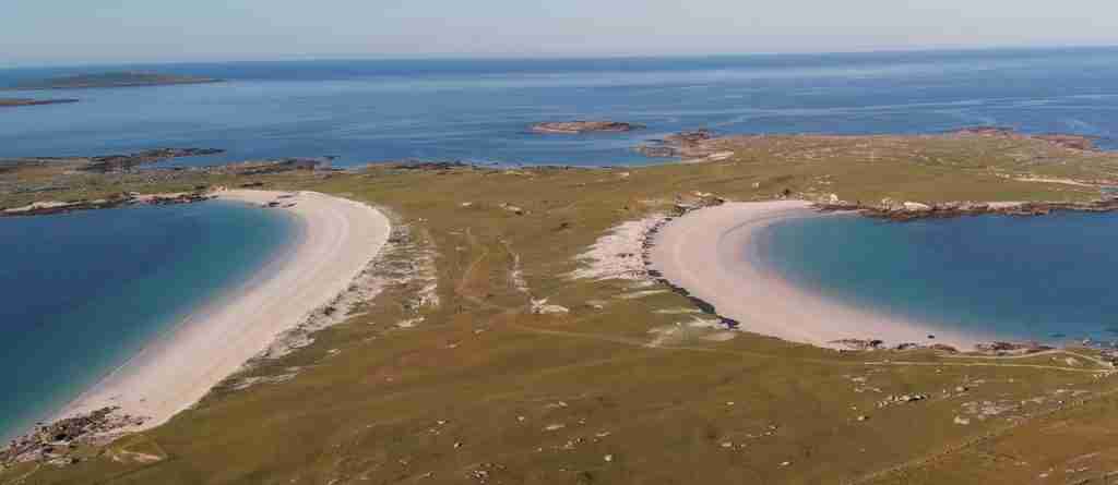
- Coastal Secrets: Dog’s Bay and Gurteen Bay form a rare double-beach tombolo system with Caribbean-blue waters and shell sand beaches that remain remarkably uncrowded even in summer, while the Coral Strand at Carraroe offers one of Ireland’s few maerl beaches composed entirely of coralline algae fragments.
- Archaeological Wonders: The Aughnanure Castle near Oughterard stands as one of Ireland’s best-preserved tower houses with intact banqueting hall and murder holes, while the Turoe Stone near Loughrea represents the finest example of La Tène Celtic art in Ireland, predating written Irish history by centuries.
- Hidden Villages: Roundstone remains an unspoiled fishing village where traditional currach boats are still handcrafted using techniques unchanged since medieval times, while Kinvara’s medieval streets and harbor create a timeless atmosphere rarely found in more tourist-focused destinations.
- Secret Landscapes: The Maumturk Mountains offer wilderness hiking without the crowds of Connemara National Park, while Lough Inagh Valley provides some of Ireland’s most dramatic mountain scenery framed by reflective waters and accessible via quiet backroads.
- Artisan Discoveries: Connemara’s Twelve Bens region hosts working farms producing artisan cheeses, smoked salmon, and traditional wool products using methods passed down through generations, with most welcoming visitors for farm tours and tastings by appointment.
- Cultural Experiences: Traditional music sessions in villages like Spiddal and Oughterard attract genuine musicians playing for locals rather than tourists, while Irish language immersion opportunities in Gaeltacht communities provide authentic cultural connections impossible to find in English-speaking Ireland.
People Also Ask About Galway Hidden Gems
What are the most underrated beaches near Galway?
Dog’s Bay and Gurteen Bay near Roundstone form Ireland’s only tombolo beach system, where two pristine shell-sand beaches curve back-to-back separated by a narrow land bridge. The beaches face opposite directions, offering sheltered swimming regardless of wind direction. The Coral Strand at Carraroe consists entirely of maerl, a rare coralline algae that creates bright pink-white sand found in only a handful of locations worldwide. Glassilaun Beach near Renvyle requires a short walk from the parking area but rewards visitors with complete isolation, turquoise waters, and views across to Clare Island. Silver Strand near Barna sits just west of Galway City but remains relatively unknown, offering safe swimming, rock pools, and stunning sunsets without the crowds of Salthill’s beaches.
Where can I find authentic Irish cultural experiences in Galway?
The Gaeltacht communities along Connemara’s coast, particularly around Spiddal, Carraroe, and Carna, preserve Irish as the daily language and maintain traditions largely disappeared elsewhere. Several families offer homestays where visitors experience authentic Irish-speaking households, traditional music, and home-cooked meals featuring local ingredients. Tigh Fitz in Spiddal hosts nightly traditional music sessions where local musicians gather to play purely for enjoyment rather than performance. The Connemara Smokehouse near Ballyconneely offers tours demonstrating traditional salmon smoking techniques using turf and oak, followed by tastings of various smoked fish products. Oughterard’s traditional pubs like Faherty’s and Keough’s maintain authentic atmosphere with regular impromptu music sessions attracting local musicians and storytellers.
What hidden historical sites exist in Galway beyond the obvious tourist attractions?
Aughnanure Castle near Oughterard stands as Ireland’s best-preserved six-story tower house, complete with intact banqueting hall, spiral staircases, and defensive murder holes, yet receives a fraction of Dunguaire Castle’s visitors. The Turoe Stone near Loughrea displays intricate La Tène Celtic spiral carvings dating to approximately 100 BCE, representing Ireland’s finest example of pre-Christian Celtic art. Kilmacduagh Monastery near Gort features a perfectly intact 34-meter round tower leaning four degrees from vertical, alongside ruins of seven churches spanning six centuries. Ross Errilly Friary near Headford represents Ireland’s best-preserved medieval Franciscan friary, with remarkably intact cloisters, refectory, and domestic quarters revealing daily monastic life. The Brigit’s Garden near Moycullen interprets ancient Celtic festivals through contemporary gardens and stone circles, offering insight into pre-Christian Irish spirituality.
Which Connemara villages offer the most authentic local atmosphere?
Roundstone remains remarkably unspoiled despite its beauty, with working fishing boats still departing daily and traditional currach-building workshops operating using medieval construction techniques. The village’s pubs and restaurants serve local fishermen alongside visitors, maintaining genuine community character. Cleggan, a small fishing village north of Clifden, operates as a working port with lobster boats and trawlers dominating the harbor, while its pubs like Oliver’s serve fresh seafood to locals and the occasional visiting sailor. Leenaun sits at the head of Killary Harbour, Ireland’s only fjord, with sheep farms extending up the surrounding mountains and traditional wool-processing shops demonstrating carding, spinning, and weaving. Lettermore and Lettermullan on Connemara’s south coast maintain strong Irish-language traditions, with shops conducting business in Irish and residents preserving traditional lifestyles largely unchanged despite proximity to Galway City.
Extended multi-day tours – 5+ days
Featured Galway Multi-Day Tour Packages

3 days
Galway 3-Day Discovery Tour
- ✓ Comprehensive Galway experience
- ✓ Expert local guides included
- ✓ All accommodation included
- ✓ Transportation provided

5 days
Galway 5-Day Highlights Experience
- ✓ Comprehensive Galway experience
- ✓ Expert local guides included
- ✓ All accommodation included
- ✓ Transportation provided
7 days
Galway 7-Day Cultural Journey
- ✓ Comprehensive Galway experience
- ✓ Expert local guides included
- ✓ All accommodation included
- ✓ Transportation provided

10 days
Galway 10-Day Complete Adventure
- ✓ Comprehensive Galway experience
- ✓ Expert local guides included
- ✓ All accommodation included
- ✓ Transportation provided
Multi-day tour packages powered by TourRadar. Prices and availability subject to change.
Introduction: Discovering Galway’s Secret Ireland
Galway’s fame rests on iconic attractions like the Cliffs of Moher, the colorful streets of the Latin Quarter, and the dramatic landscapes of Connemara National Park. These deservedly popular destinations draw millions of visitors annually, their beauty and cultural significance justifying their reputation. However, this concentration of tourism in well-known locations means that extraordinary landscapes, historical treasures, and authentic cultural experiences exist mere kilometers away, visited by only a handful of curious travelers willing to explore beyond the guidebook highlights.
The Wild Atlantic Way, stretching from Galway Bay northward through Connemara and into Mayo, encompasses some of Europe’s most dramatic coastal scenery alongside landscapes of remarkable diversity. Within this region, hidden beaches composed of rare coral sand remain empty even during peak summer weeks, medieval castles stand intact yet unvisited, and traditional Irish-speaking communities maintain cultural practices disappeared elsewhere. These discoveries reward the explorer not with Instagram-perfect moments engineered for tourists, but with genuine encounters with Ireland’s landscapes, history, and living culture.
This hidden Galway exists in the spaces between major attractions. The backroad from Galway to Clifden via Spiddal and Carraroe passes through Irish-speaking villages where shop signs appear in Gaelic, traditional music sessions happen spontaneously rather than on schedule, and locals gather in pubs that have served the same families for generations. The mountains inland from Letterfrack offer wilderness hiking without the crowds of Diamond Hill, while the islands offshore from Carna and Roundstone preserve landscapes and lifestyles largely unchanged since the 19th century.
Understanding Galway’s hidden treasures requires recognition of the region’s geographic and cultural complexity. Connemara alone encompasses bog landscapes, mountain ranges, countless lakes, offshore islands, and coastal zones ranging from sheltered bays to exposed Atlantic headlands. The cultural landscape proves equally varied, with the Gaeltacht Irish-speaking regions maintaining distinct identity from English-speaking Galway City and the market towns of East Galway. This diversity creates countless microregions, each with unique character, where the curious traveler discovers experiences impossible to replicate elsewhere.
The most rewarding hidden gems share certain characteristics. They remain largely unknown because they require effort to reach, lack prominent signage, or exist in locations that appear unremarkable on maps. Many lack facilities, meaning visitors must be self-sufficient. The beaches rarely have lifeguards or cafes, the castles typically have no visitor centers, and the best traditional music sessions happen in ordinary-looking pubs where strangers might initially feel out of place. This lack of tourism infrastructure preserves authenticity while requiring travelers to be more independent and culturally sensitive than mass-market tourism demands.
This guide reveals these hidden treasures across several categories: coastal discoveries including secret beaches and dramatic headlands; archaeological and historical sites from prehistoric monuments to medieval ruins; hidden villages maintaining traditional character; natural landscapes from mountain valleys to bog ecosystems; artisan producers crafting traditional products; and authentic cultural experiences from music sessions to language immersion. Each section provides specific locations, detailed directions, practical information for visiting, and context explaining why these places matter.
The organization follows geographic logic, beginning with coastal hidden gems accessible from Galway City, then moving through Connemara’s interior landscapes, examining the islands offshore, exploring East Galway’s lesser-known attractions, and concluding with seasonal considerations and practical advice for discovering hidden Galway independently. This structure allows travelers to combine multiple hidden gems into coherent day trips or multi-day explorations while understanding the cultural and natural context that makes each discovery significant.
Secret Beaches and Coastal Wonders
Galway’s coastline extends approximately 160 kilometers from Kinvara in the south to Killary Harbour in the north, encompassing dramatic variety from sheltered sandy bays to exposed rocky headlands. While tour buses crowd the Cliffs of Moher and families fill Salthill’s beaches, extraordinary coastal treasures remain remarkably empty, offering solitude, pristine beauty, and unique geological features found nowhere else in Ireland.
Dog’s Bay and Gurteen Bay: Ireland’s Tombolo Beaches
Dog’s Bay and Gurteen Bay near Roundstone create Ireland’s only tombolo formation, where two crescent beaches of shell sand connect a small peninsula to the mainland. The beaches face opposite directions—Dog’s Bay northwest, Gurteen Bay southeast—meaning one always offers shelter regardless of wind direction. The sand consists almost entirely of crushed seashells and skeletal fragments of foraminifera, tiny single-celled organisms whose calcium carbonate shells create the distinctive bright white color and fine texture.
Both beaches stretch approximately 500 meters, backed by low dunes supporting wildflowers including sea pinks, orchids, and rare plants adapted to shell-sand conditions. The waters display remarkable clarity and color, ranging from turquoise in shallow areas to deep blue in the bay channels. Swimming proves excellent in calm conditions, though currents strengthen during incoming tides and strong winds. The peninsula between the beaches rises to a modest hill offering panoramic views across both bays, the Twelve Bens mountains, and the offshore islands.
Access requires driving through Roundstone village and following signs toward Dog’s Bay for approximately two kilometers on narrow roads. Limited parking exists at both beaches, filling quickly on sunny summer weekends but rarely crowded on weekdays or outside peak season. No facilities exist beyond the natural landscape—bring all supplies including water, food, and sun protection. The beaches face fully west and southwest, making them spectacular sunset viewpoints but exposed to Atlantic weather systems.
The tombolo formation itself represents a rare geological feature. The connecting land bridge formed through deposition of shell sand carried by tidal currents from both directions, gradually building up until it created a permanent land connection. This process continues today, with the beaches subtly changing shape each year depending on storm patterns and sediment movement. The shell composition makes the sand unusually white and fine, though less stable for beach activities than quartz sand beaches.
Coral Strand, Carraroe: Ireland’s Maerl Beach
The Coral Strand at Carraroe consists entirely of maerl, a coralline algae that forms calcium carbonate structures resembling coral. These pink-white fragments create a beach unique in Ireland and rare globally, found in fewer than a dozen locations worldwide. The maerl forms offshore in shallow waters where the algae grows slowly over decades, eventually breaking free and washing ashore during storms to accumulate above the tide line.
The beach extends approximately 300 meters along Casla Bay, backed by low rocky outcrops and accessed via a small parking area off the R336 coast road. The strand faces south-southwest, offering sheltered swimming conditions and warming quickly in summer sunshine. The unusual composition creates distinctive crunching sounds underfoot and remarkable color variations from bright white through various pink shades to deep coral red, depending on the age and mineral content of individual fragments.
Maerl ecosystems support exceptional marine biodiversity, with the algae beds providing habitat for numerous fish species, crustaceans, and mollusks. The beach itself functions as a geological indicator, with maerl accumulation rates reflecting ocean health and climate patterns over time. Collection or removal of maerl is illegal under European environmental protection laws, as the algae grows extremely slowly and beds take centuries to recover from damage.
The beach sits within the Connemara Gaeltacht, with Irish the predominant language in surrounding villages. Small shops in Carraroe offer basic supplies, while An Chéibh restaurant and pub serves excellent seafood and maintains an authentic local atmosphere. The coastal road continues west through additional Gaeltacht communities toward Carna, passing numerous small beaches, rocky headlands, and traditional stone walls bordering the road.
Glassilaun Beach: Turquoise Waters and Complete Isolation
Glassilaun Beach near Renvyle offers turquoise Caribbean-like waters, white sand, and mountain backdrop without the crowds found at more accessible beaches. Reaching Glassilaun requires turning off the main road north of Letterfrack and following increasingly narrow roads for several kilometers, then parking and walking approximately 800 meters on a rough track unsuitable for vehicles. This access difficulty ensures the beach remains relatively unknown despite its extraordinary beauty.
The beach stretches roughly 400 meters along a sheltered bay facing north across Ballynakill Harbour toward Clare Island. The sand is fine quartz mixed with crushed shells, creating a bright white appearance that contrasts dramatically with the blue-green water colors. Rocky outcrops at both ends of the beach provide tide pools rich with marine life, while the surrounding hills support grazing sheep and traditional stone walls extending down to the shoreline.
Swimming conditions vary with tides and weather but generally prove safe in the sheltered bay during calm conditions. The beach slopes gradually, making it suitable for children in supervised settings. No lifeguards, facilities, or mobile phone coverage exist—visitors must be completely self-sufficient. The beach faces northwest, receiving afternoon sun and offering spectacular sunsets across Ballynakill Harbour and the Atlantic beyond.
The access walk crosses open hillside on a rough track that becomes muddy after rain. Wear appropriate footwear and be prepared for changeable weather, as the exposed location offers no shelter from sudden squalls common along the Atlantic coast. The walk rewards with increasingly dramatic views as the beach comes into view, revealing the full sweep of white sand and turquoise water framed by mountains rising behind.
Silver Strand, Barna: Hidden Beach Near Galway City
Silver Strand sits just nine kilometers west of Galway City center yet remains relatively quiet compared to the adjacent beaches at Salthill. The strand curves in a protected arc facing southwest, backed by low grassy dunes and accessed via a small car park off the coast road. The beach extends approximately 200 meters, with fine golden sand and gradual slope making it excellent for swimming, particularly at high tide when the water depth increases.
Rock pools at both ends of the beach reveal diverse marine life including crabs, small fish, anemones, and various mollusks. The western end features larger rocks suitable for climbing, while the eastern end connects to a small stream that creates a shallow lagoon popular with children. The beach maintains a local character, with Galway residents using it for regular swimming, dog walking, and family outings rather than day-trippers from further afield.
The strand faces directly west, making it one of Galway’s premier sunset viewpoints. On clear evenings, the sun sets directly into the Atlantic, creating spectacular displays of color reflected in the wet sand and shallow waters. The nearby O’Connors pub and restaurant offers casual dining with outdoor seating overlooking the beach, while the Twelve Hotel provides upscale accommodation with beach access.
Tides significantly affect the beach character and swimming conditions. At low tide, extensive sand flats appear, revealing patterns of ripples and creating ideal conditions for beach walking and exploring tidal zones. At high tide, the water reaches the dune base, creating a narrow swimming beach with more dramatic wave action. Check tide times before visiting, as the beach experiences fully twice-daily tidal cycles with approximately 3-4 meter range between high and low water.
Mannin Bay: Hidden Coves and Coral Sand
Mannin Bay stretches along the coast between Ballyconneely and Clifden, encompassing numerous small beaches and coves accessible via minor roads and farm tracks. The bay features several beaches with coral sand similar to the Coral Strand but smaller and more secluded. These hidden strands require local knowledge to find, as signage is minimal and access often crosses private farmland requiring respectful behavior and adherence to the countryside code.
The largest accessible beach sits at the bay’s southern end near Ballyconneely, reached via a small road off the main coast route. This beach offers approximately 400 meters of white sand, sheltered swimming, and views across the bay to the Twelve Bens mountains. Several smaller coves lie along the northern shore, accessible via rough tracks from the Clifden-Ballyconneely road. These intimate beaches rarely see more than a handful of visitors even during peak season.
The bay’s shallow waters warm quickly in summer sunshine, making it excellent for swimming and water sports. Local operators offer kayaking and stand-up paddleboarding, with the sheltered conditions ideal for beginners. The surrounding landscape features typical Connemara character with stone-walled fields, scattered farmhouses, and grazing sheep extending to the shoreline. Traditional turf cutting still occurs in nearby bogs, with stacked turf visible along roadsides during summer and autumn.
Several beaches along Mannin Bay allow wild camping with landowner permission, though facilities are nonexistent and campers must practice strict leave-no-trace principles. The area attracts artists drawn to the distinctive light quality and landscape character, with several small galleries in Ballyconneely and Clifden displaying work inspired by the bay’s beauty. Morning light proves particularly spectacular, with low sun illuminating the Twelve Bens while casting long shadows across the beaches and shallow waters.
Hidden Archaeological and Historical Treasures
Galway’s long history from prehistoric settlement through medieval monastic centers to Norman conquest left remarkable archaeological remains across the landscape. While some sites like Kilmacduagh Monastery receive attention, extraordinary historical treasures remain virtually unknown, offering insight into Irish history from the Celtic period through the medieval era without crowds or commercialization.
Aughnanure Castle: Ireland’s Best-Preserved Tower House
Aughnanure Castle near Oughterard represents one of Ireland’s finest and most complete tower house castles, built by the O’Flaherty clan around 1500. The six-story structure stands intact with original floors, spiral staircases, defensive features, and architectural details revealing daily life in medieval Gaelic Ireland. Despite its exceptional preservation and historical significance, the castle receives a fraction of the visitors drawn to more famous but less complete ruins elsewhere.
The castle demonstrates sophisticated defensive architecture including murder holes above doorways, narrow window slits for archery, and thick walls designed to resist cannon fire. The top floor served as the chieftain’s private quarters, while lower floors housed soldiers, servants, and supplies. The banqueting hall on the third floor retains its original fireplace large enough to roast entire animals, with stone benches built into window embrasures overlooking the surrounding countryside.
The castle stands on a rocky outcrop surrounded on three sides by water, with the Drimneen River creating natural defenses enhanced by medieval earthworks still visible in the surrounding fields. A small gatehouse controls access to the castle yard, while collapsed sections of defensive walls indicate the extent of the original fortified compound. The setting amid rolling farmland with the Lough Corrib shoreline nearby creates a remarkably intact medieval landscape context.
The castle operates under the Office of Public Works with limited opening hours from May through September, typically 9:30 AM to 6:00 PM daily. Admission costs €5 for adults with reduced rates for seniors and children. The site provides interpretive panels explaining the castle’s history and architecture, though no guided tours operate regularly. The castle interior requires climbing steep spiral staircases with uneven stone steps—wear appropriate footwear and exercise caution, particularly with children.
Access to Aughnanure Castle requires driving approximately three kilometers east from Oughterard on the R336 toward Galway City, then turning north on a minor road marked with heritage site signs. Limited parking exists near the entrance, adequate for the modest visitor numbers. The surrounding area offers additional attractions including Aughnanure Church ruins, Lough Corrib boat tours, and traditional music sessions in Oughterard’s pubs.
The Turoe Stone: Celtic Art Masterpiece
The Turoe Stone near Loughrea stands as Ireland’s finest example of La Tène Celtic art, featuring intricate curvilinear designs carved into granite approximately 2,100 years ago. The dome-topped stone stands roughly one meter tall, with its surface covered in flowing spiral patterns, triskeles, and abstract motifs characteristic of the La Tène artistic tradition that flourished across Celtic Europe during the Iron Age. The stone’s exceptional preservation and artistic sophistication make it nationally significant, yet it sits in a small enclosure receiving minimal visitors.
The carving technique demonstrates remarkable skill, with designs executed using pecking and grinding methods on extremely hard granite. The patterns flow continuously around the stone’s surface without clear beginning or end, suggesting symbolic meanings related to Celtic spiritual beliefs about cyclical time and cosmic unity. Similar stones exist elsewhere in Europe, but the Turoe Stone represents the finest Irish example and one of the best-preserved Celtic art pieces from the pre-Christian period.
The stone’s original location and purpose remain subjects of archaeological debate. Discovered on nearby Feerwore Hill and moved to its current location in the 19th century, it likely served as a ritual object associated with Celtic religious practices. The elaborate decoration suggests it held significant ceremonial importance, possibly marking a sacred site, serving as a territorial marker, or functioning in rituals now lost to history. The hilltop discovery location offered commanding views across surrounding lowlands, typical of Celtic ritual sites.
The stone now stands in a small dedicated enclosure at Turoe Pet Farm, accessible during farm opening hours from March through October. Admission to the farm costs €10 for adults, €8 for children, with the Turoe Stone included in the general admission price. The farm context seems incongruous with the stone’s archaeological significance, but the owners maintain the site respectfully and provide interpretive information about its history and importance. Viewing requires no climbing or hiking—the stone sits immediately inside the farm entrance.
The surrounding area includes additional archaeological features including ring forts, early medieval church sites, and the remains of Turoe House, a Georgian mansion that once stood near the stone. The countryside retains strong agricultural character with working farms, stone walls, and hedgerows creating a landscape likely similar to that known by the ancient Celts who created this masterpiece. The proximity to Loughrea makes it easily combined with visits to the town’s cathedral, medieval friary ruins, and traditional shops.
Ross Errilly Friary: Ireland’s Best-Preserved Medieval Monastery
Ross Errilly Friary near Headford represents Ireland’s largest and best-preserved Franciscan friary, with remarkably intact cloisters, living quarters, church, and domestic buildings revealing daily life in a medieval Irish monastery. Founded in 1498, the friary operated until suppression during the 16th-century Protestant Reformation, after which it fell gradually into ruin while retaining exceptional structural integrity compared to most Irish monastic sites.
The complex demonstrates sophisticated monastic architecture with distinct areas for religious observance, communal living, food preparation, and administration. The church features nave, choir, and multiple side chapels, with soaring Gothic arches and detailed stone carving on capitals and window surrounds. The cloister arcade surrounding a central courtyard remains substantially complete, allowing visitors to walk the covered walkways as medieval friars did centuries ago. The refectory retains its original stone reading lectern where a friar would read scripture during communal meals, while the kitchen preserves water tanks, fireplaces, and ovens large enough to serve the entire community.
The friary’s exceptional preservation owes to its remote location and substantial construction using local limestone. Unlike many Irish monasteries deliberately destroyed during the Reformation or later repurposed for other buildings, Ross Errilly simply fell into gradual decay through natural weathering rather than deliberate destruction. The result is a remarkably complete medieval monastic complex where the spatial relationships between different functional areas remain clear and the architectural sophistication of 15th-century Irish builders appears evident.
The site remains freely accessible year-round with no admission charge, operating as a national monument under the care of the Office of Public Works. No visitor center or guided tours exist—visitors explore independently using on-site interpretive panels. The complex requires careful navigation of uneven stone floors, narrow staircases, and areas where floors have collapsed. Wear sturdy footwear, watch children carefully, and exercise caution exploring upper levels. The isolated location means no nearby facilities—bring water and snacks.
Access requires driving north from Galway on the N84 toward Headford, then turning west approximately one kilometer south of Headford onto a minor road marked with heritage site signs. The friary sits about one kilometer down this road, with parking in a small gravel lot adjacent to the entrance. The surrounding countryside features typical Galway lowland landscapes with pastures, stone walls, and scattered farmhouses extending to the horizon. The friary’s isolation contributes to the contemplative atmosphere, making it easy to imagine the quiet monastic life that characterized the site for centuries.
Kilmacduagh Monastery: The Leaning Tower and Seven Churches
Kilmacduagh Monastery near Gort comprises ruins of seven churches spanning six centuries, alongside a remarkably preserved 34-meter round tower leaning four degrees from vertical. Founded in the 7th century by Saint Colman, the monastery grew into a significant ecclesiastical center during Ireland’s medieval period, with multiple churches serving different functions and periods. The site’s exceptional preservation, architectural variety, and distinctive leaning tower create one of Ireland’s most impressive monastic complexes, yet it remains relatively unknown compared to more famous sites like Glendalough.
The round tower dominates the site, rising 112 feet with its characteristic conical cap intact despite the pronounced lean. The tilt developed over centuries as the tower’s foundation settled unevenly in the soft ground, creating the four-degree angle visible today. Despite this dramatic lean, the tower remains structurally sound, testament to the sophisticated engineering of medieval Irish builders. The tower served defensive purposes, allowing monks to retreat inside during Viking raids while storing valuable manuscripts and sacred objects in upper chambers accessible only by ladder.
The cathedral church represents the site’s largest building, with nave, choir, and transepts demonstrating Romanesque and Gothic architectural styles as the structure expanded over several building phases. Original 12th-century sections feature characteristic Romanesque rounded arches and geometric decoration, while later Gothic additions introduce pointed arches and larger windows. The church’s east window retains elaborate stone tracery, while carved capitals display human faces, animals, and abstract patterns typical of medieval Irish sculpture.
The smaller churches scattered across the site served specialized functions including parish churches for local communities, private chapels for monastic patrons, and possibly mortuary chapels for specific family lineages. These buildings range from simple stone rectangles to more elaborate structures with decorated doorways and windows. The Glebe House, a small 15th-century stone building, likely served as the abbot’s residence, with fireplace and upper floor indicating domestic rather than purely religious function.
The monastery sits in isolated countryside southeast of Gort, accessible via the R460 road toward Corofin with clear heritage signage. The site operates as a national monument with free access year-round, though no visitor center or facilities exist. Visitors park in a small gravel lot and walk through fields to reach the ruins, following clear paths through the monastic complex. The setting retains strong rural character with surrounding farmland, stone walls, and the Burren limestone visible in the near distance creating a landscape context likely similar to the monastery’s medieval heyday.
Dún Aonghasa, Aran Islands: Bronze Age Clifftop Fort
While not strictly “hidden” given its UNESCO World Heritage designation and regular visitor traffic, Dún Aonghasa on Inis Mór merits inclusion as one of Europe’s most dramatic prehistoric monuments, perched on 100-meter cliffs overlooking the Atlantic with construction dating to approximately 1100 BCE. The semicircular fort’s extraordinary location, sophisticated defensive architecture, and mysterious purpose create an archaeological site of international significance that rewards the effort required to reach it.
The fort comprises three concentric stone walls protecting a roughly semicircular enclosure with the Atlantic cliffs forming the fourth side. The inner enclosure measures approximately 50 meters in diameter, enclosed by a massive wall up to four meters thick built entirely of dry-stone construction without mortar. Two additional defensive walls extend outward, with the middle wall surrounded by a chevaux-de-frise—a defensive field of vertical stone pillars designed to break up attacking formations. This sophisticated defensive architecture demonstrates remarkable Iron Age engineering and military strategy.
The fort’s purpose remains debated among archaeologists. The clifftop location offers extraordinary defensive advantages but minimal living space and no water supply, suggesting ceremonial rather than permanent settlement function. Some researchers propose the fort served as a ritual site, possibly related to Bronze Age solar worship given its orientation toward the setting sun. Others suggest it functioned as a refuge fort where local populations retreated during conflicts, using the cliffs as final defense and possibly escaping by boat down the cliff face if necessary.
Reaching Dún Aonghasa requires taking a ferry from Rossaveal or Doolin to Inis Mór, then walking or cycling approximately seven kilometers from the main village of Kilronan to the fort entrance. The final approach involves a steep 20-minute climb on a well-maintained stone path ascending the hillside. The visitor center at the base provides historical context, archaeological information, and safety warnings about the unprotected cliff edge at the fort’s perimeter. No barriers prevent visitors from approaching the vertical cliff drop—exercise extreme caution, particularly in windy conditions or with children.
The fort opens daily year-round with admission costs of €5 for adults. Winter visits offer solitude and dramatic weather but require appropriate clothing for strong winds and potential rain. Summer brings crowds, particularly when multiple tour groups arrive simultaneously during midday hours. Early morning or late afternoon visits avoid peak congestion while offering superior light conditions for photography and contemplative atmosphere for experiencing this extraordinary site’s power.
Hidden Villages and Authentic Communities
Galway’s villages range from well-known tourist destinations like Clifden to genuinely undiscovered communities maintaining traditional character and local atmosphere. The most rewarding hidden villages combine architectural charm, authentic local culture, and settings that reveal traditional Irish life beyond the tourism economy. These communities welcome respectful visitors while maintaining their primary identity as living, working villages rather than heritage attractions.
Roundstone: Traditional Fishing Village and Currach Building
Roundstone sits on Connemara’s southern coast, a working fishing village where traditional life continues alongside modest tourism. The village’s harbor hosts active fishing boats, with catches of lobster, crab, and various fish landed daily and sold at dockside or shipped to Galway markets. The surrounding landscape features bog, low mountains, and scattered lakes creating quintessential Connemara scenery without the crowds found in more accessible locations.
The village’s architectural character reflects its 19th-century development as a fishing port, with color-washed buildings lining the harbor front and narrow streets climbing the hillside behind. Several traditional shops including a hardware store, butcher, and grocer serve local residents rather than tourists, maintaining a genuine village economy alongside craft shops and galleries. The parish church occupies a prominent hilltop position visible from the harbor, its spire serving as a navigation landmark for fishing boats returning from sea.
Roundstone’s currach-building tradition represents one of Ireland’s few remaining locations where traditional canvas-covered boats are constructed using techniques unchanged since medieval times. Mairtin O’Malley’s workshop produces currachs for racing, fishing, and traditional purposes, with visitors welcome to observe the construction process demonstrating ancient woodworking and canvas-covering skills. The workshop also builds traditional Irish instruments including bodhráns, the frame drums central to Irish traditional music.
The village hosts several excellent pubs and restaurants maintaining local character. O’Dowd’s serves fresh seafood including catches from Roundstone boats, with outdoor seating overlooking the harbor and regular traditional music sessions during summer evenings. Vaughan’s Anchor Inn operates as a genuine local pub where fishermen and farmers gather alongside visitors, with unpretentious atmosphere and decent food. The village bakery produces exceptional breads, cakes, and savory items using traditional recipes and local ingredients.
Roundstone serves as an excellent base for exploring Connemara’s southern coast, with Dog’s Bay, Gurteen Bay, and numerous walking trails accessible within short drives. The village has limited accommodation including small hotels, B&Bs, and holiday cottages, with advance booking essential during summer months. The surrounding area offers traditional music sessions, art galleries, and opportunities for experiencing authentic Irish rural life beyond the tourism mainstream.
Kinvara: Medieval Harbor Village
Kinvara occupies a sheltered position at the head of Galway Bay, its medieval street pattern and working harbor creating timeless atmosphere enhanced by the magnificent Dunguaire Castle overlooking the village. Unlike more tourism-focused destinations, Kinvara maintains genuine local character with fishing boats, traditional shops, and community life continuing as it has for centuries. The village serves South Galway farming communities while attracting artists and musicians drawn to its beauty and cultural authenticity.
The harbor front forms Kinvara’s heart, with traditional Galway hookers—wooden sailing boats with distinctive rust-colored sails—moored alongside modern fishing vessels. These historic boats participate in annual races during Cruinniú na mBád festival each August, when hookers from across Galway Bay gather for traditional sailing competitions, music sessions, and celebration of maritime heritage. The harbor’s sheltered waters and stone quays create perfect settings for sunset walks and observing traditional boat handling techniques.
Kinvara’s medieval street pattern retains its original layout, with narrow lanes connecting the harbor to the square and church. Traditional shopfronts include a butcher, baker, hardware store, and several pubs maintaining authentic character. Greene’s Bar operates as a genuine local pub with traditional music sessions several nights weekly, while Tully’s hosts regular sessions attracting top musicians from across the region. The music happens spontaneously rather than on rigid schedules—ask locally about session times, which vary seasonally.
Dunguaire Castle dominates the village from its rocky promontory overlooking the harbor. Built in 1520 on the site of an earlier fort, the tower house represents typical Irish defensive architecture with thick walls, defensive features, and commanding position controlling harbor access. The castle operates with guided tours during summer months, including evening medieval banquets featuring traditional food, music, and storytelling. However, the castle’s exterior beauty and harbor setting prove equally impressive viewed from the village streets and waterfront walkways.
The village hosts several annual events maintaining traditional culture. The Cuckoo Fleadh in May brings traditional music performances, workshops, and sessions throughout the village pubs and streets. The aforementioned Cruinniú na mBád festival in August celebrates maritime heritage with hooker races, boat building demonstrations, and harbor festivities. These events attract primarily Irish participants rather than international tourists, maintaining authentic cultural atmosphere while welcoming respectful visitors.
Leenaun: Ireland’s Only Fjord Village
Leenaun sits at the head of Killary Harbour, Ireland’s only true fjord, where glacial activity carved a deep inlet extending 16 kilometers inland from the Atlantic. The village occupies a dramatic setting surrounded by mountains, with the Maumturk range rising to the south and the Mweelrea massif dominating the north shore. This landscape creates one of Ireland’s most spectacular natural settings, yet Leenaun remains relatively undiscovered compared to more accessible Connemara destinations.
The village serves as a working community for surrounding sheep farms, with traditional wool processing remaining economically important. The Leenaun Sheep and Wool Centre demonstrates traditional and modern wool production including sheep shearing, wool dyeing using natural plant materials, and weaving on traditional looms. The center provides insight into an industry central to Connemara’s economy for centuries, with demonstrations explaining how the region’s sheep breeds evolved to thrive in harsh Atlantic conditions while producing wool particularly suited for traditional Irish sweaters and textiles.
Killary Harbour supports mussel farming, with floating rafts visible across the fjord’s calm waters. The deep, sheltered waters create ideal conditions for shellfish cultivation, with mussels harvested year-round and shipped to markets across Ireland and Europe. Several local restaurants serve fresh mussels and other seafood, including Blackberry Café with harbor views and Nancy’s Point Bar offering traditional pub atmosphere with food emphasizing local ingredients.
The surrounding mountains offer exceptional hiking, including the Maumturk Walk, a challenging 25-kilometer ridge traverse crossing multiple summits with spectacular views across Connemara. Less demanding walks include valley trails following streams into the mountains or coastal paths along Killary Harbour’s shoreline. The area attracts serious hillwalkers rather than casual tourists, with proper navigation skills and equipment essential for mountain routes. The Killary Adventure Centre offers guided hikes, water sports, and cultural programs for visitors wanting structured outdoor experiences.
Leenaun’s isolation and dramatic setting attracted filmmakers, with several notable productions shot in the area. The village appeared in “The Field” starring Richard Harris, with scenes capturing the landscape’s stark beauty and the community’s connection to the land. More recently, productions have used Killary Harbour’s fjord-like character for scenes requiring dramatic coastal settings. The village embraces this film heritage without becoming a tourist trap, maintaining its identity as a working community where traditional life continues.
Spiddal: Gaeltacht Heart of Connemara
Spiddal (An Spidéal) serves as the gateway to Connemara’s Gaeltacht region, where Irish remains the daily language and traditional culture maintains stronger presence than anywhere outside the western islands. The village straddles the coast road west of Galway City, its position marking the transition from English-speaking suburbs to Irish-speaking communities extending through Connemara’s coastline. This linguistic and cultural boundary creates unique character combining accessibility from Galway with authentic Irish language and traditional life.
The village’s shops, pubs, and public signage operate primarily in Irish, with residents conducting daily business in the language that was Ireland’s primary tongue before English colonization. For visitors with no Irish, this creates both challenge and opportunity—challenge in that many conversations happen in a language you cannot understand, opportunity to experience living Irish culture impossible to find in English-speaking Ireland. Most residents speak English when addressed but appreciate efforts to learn basic Irish greetings and phrases.
Tigh Fitz operates as Spiddal’s premier traditional music venue, hosting nightly sessions during summer and weekend sessions year-round. Unlike tourist-oriented “traditional music shows,” these sessions attract genuine musicians gathering to play for their own enjoyment. Visitors are welcome to listen respectfully, understanding that the music happens for the musicians and local community rather than as entertainment for outsiders. The best sessions occur spontaneously when multiple skilled musicians arrive unscheduled, creating extraordinary musical experiences impossible to replicate in staged performances.
The Spiddal Craft Village hosts several artisan workshops including pottery, weaving, jewelry making, and traditional Irish crafts. The complex allows visitors to observe craftspeople working and purchase directly from makers, with prices generally lower than retail shops while supporting artists directly. The craft village also includes a café serving local ingredients and traditional dishes including Irish stew, seafood chowder, and homemade baked goods. The village hosts occasional craft fairs and cultural events, advertised locally rather than promoted to wider audiences.
Spiddal’s coastline offers pleasant beach walks and rocky shore explorations, with views across Galway Bay to the Burren and Clare coast visible on clear days. The Spiddal Beach, while not spectacular by Connemara standards, provides safe swimming and local atmosphere with Galway families rather than international tourists predominating. The coastal road west from Spiddal passes through additional Gaeltacht villages including Inverin and Carraroe, with opportunities to experience Irish language immersion, traditional music, and authentic rural culture throughout the region.
Secret Natural Landscapes and Wilderness Areas
Connemara’s fame rests on dramatic coastal scenery and the Twelve Bens mountains, but extraordinary natural landscapes exist beyond the national park boundaries, offering wilderness experiences without crowds. These hidden natural areas reward explorers with solitude, dramatic scenery, and opportunities to experience Ireland’s wild landscapes as they existed before tourism infrastructure.
Maumturk Mountains: Wilderness Ridge Walking
The Maumturk Mountains form a roughly north-south ridge parallel to the better-known Twelve Bens, offering more challenging hiking with equally spectacular scenery and far fewer walkers. The range comprises nine peaks over 600 meters, with the full ridge traverse covering approximately 25 kilometers and ascending over 2,300 meters of cumulative elevation. This demanding route ranks among Ireland’s finest mountain walks, requiring full-day commitment, good fitness, and solid navigation skills, but rewarding with unmatched views and genuine wilderness experience.
The ridge walk can be completed south-to-north starting near Maam Cross or north-to-south from Leenaun, with the northern approach generally preferred for superior views and following prevailing weather patterns. The route follows the ridge crest across all nine summits, with steep ascents and descents between peaks, exposed rocky sections requiring scrambling, and navigation challenges when clouds obscure the ridge. The terrain varies from grassy slopes to rocky summits to boggy saddles, demanding varied hiking skills and appropriate equipment.
Individual peaks can be climbed as day hikes rather than the full traverse, with Binn Mhór (661 meters) and Binn idir an Dá Log (702 meters) accessible from Maam Cross via relatively straightforward routes. These shorter routes offer taste of the Maumturks’ character while requiring less commitment than the full ridge. The peaks provide panoramic views across Connemara, with the Twelve Bens, Lough Corrib, and Atlantic coast visible from summit viewpoints. On exceptionally clear days, views extend to Galway Bay, the Burren, and even County Clare’s distant mountains.
The Maumturks receive far less foot traffic than Diamond Hill in Connemara National Park or popular Twelve Bens routes, meaning walkers often experience complete solitude even on summer weekends. This isolation creates authentic wilderness atmosphere but demands self-sufficiency, as mobile phone coverage is unreliable and rescue response would require significant time. Weather changes rapidly in the mountains, with conditions deteriorating quickly as Atlantic weather systems arrive. Carry appropriate clothing layers, navigation equipment including map and compass, emergency shelter, and sufficient food and water for the full day plus margin for unexpected delays.
The best walking conditions occur from May through September when daylight extends longest and temperatures prove most moderate. However, these months also bring Ireland’s wettest weather and midges that can be ferocious in calm conditions. Winter walking offers spectacular views in clear weather but requires winter mountaineering skills as the summits receive snow and ice. Spring and autumn provide compromise conditions with moderate weather, fewer midges, and minimal crowds, though shorter daylight limits the time available for completing long routes.
Lough Inagh Valley: Glacial Valley Splendor
Lough Inagh Valley forms a spectacular glacial trough between the Twelve Bens and Maumturk ranges, with a narrow lake extending several kilometers surrounded by mountain walls rising over 600 meters on both sides. The valley represents one of Connemara’s most dramatic landscapes, yet the quiet backroad accessing it receives minimal traffic compared to main routes through the region. This hidden gem offers easy access to extraordinary scenery, lakeside walks, and mountain views without the effort required for summit hiking.
The valley road follows the western lakeshore, providing constantly changing perspectives as the route curves along the water’s edge. Multiple informal parking areas allow stopping to appreciate viewpoints, access the shoreline, or begin walks into the surrounding mountains. The road surface varies from smooth tarmac to rough gravel sections, passable in normal vehicles but requiring attention and reduced speed. The route continues beyond the lake through increasingly remote landscape toward Kylemore Abbey, offering alternative access between Connemara’s coast and inland areas.
The lake itself stretches approximately five kilometers, with maximum depth exceeding 40 meters in places. The dark waters reflect surrounding peaks on calm days, creating mirror images that double the visual impact of the towering mountains. The lake supports brown trout and salmon, with fishing permitted subject to local regulations and licenses. The shoreline varies from pebbly beaches to boggy margins to rocky headlands, with the best access points occurring where streams enter the lake from side valleys.
Several marked and unmarked hiking routes begin from the valley, including approaches to Twelve Bens summits from the eastern side and Maumturk peaks from the west. The Glencoaghan Horseshoe route climbs from the valley to traverse several Twelve Bens summits before descending back to the valley road, creating a challenging full-day circuit with over 1,500 meters of ascent. Less demanding options include valley floor walks following streams into hanging valleys, revealing waterfalls, hidden loughs, and glacial features created during the ice ages.
The valley demonstrates classic glacial geomorphology, with U-shaped cross-section, hanging valleys where tributary streams cascade down steep sides, and terminal moraines marking positions where glaciers deposited debris. The steep mountain sides display evidence of glacial plucking and smoothing, with exposed bedrock showing striations carved by ice movement. These features make the valley particularly interesting for geology enthusiasts and anyone wanting to understand how ice shaped Ireland’s landscape during successive glacial periods.
Connemara Bog Landscapes: Blanket Bog Ecosystems
Approximately 70% of Connemara consists of blanket bog, a wetland ecosystem unique to western Ireland and Scotland where high rainfall and impermeable bedrock create waterlogged conditions supporting specialized plant communities. While visitors often view bogs as empty wasteland, these ecosystems harbor remarkable biodiversity, preserve ancient pollen records revealing thousands of years of climate history, and create the distinctive landscapes that define Connemara’s character. Several areas offer opportunities to experience and understand bog ecosystems beyond superficial appreciation of the scenic backdrop they provide.
The Roundstone Bog complex south of the Twelve Bens represents one of Ireland’s most extensive and intact blanket bog systems, stretching across thousands of hectares with minimal human disturbance. The bog surface appears as a vast expanse of sphagnum moss, heather, and sedges, broken by occasional rocky outcrops and countless small pools. This apparently flat landscape actually undulates constantly, with low hummocks separated by wet hollows creating a microtopography that supports different plant species adapted to varying water levels.
Bog vegetation includes carnivorous sundew plants that supplement nutrient-poor bog conditions by trapping insects on sticky leaf pads, cotton grass with distinctive white seed heads waving in the wind, and over a dozen sphagnum moss species forming the bog’s foundation. The moss grows continuously upward while lower layers compress and decay in oxygen-poor conditions, creating peat deposits that accumulate approximately one meter per thousand years. This process means modern bog surfaces sit several meters above bedrock, with peat layers preserving pollen grains, plant fragments, and occasionally preserved wooden objects revealing environmental conditions over millennia.
Walking across blanket bog requires care and proper footwear. The surface varies from relatively firm hummocks to deep wet hollows where stepping off solid ground can result in sinking knee-deep in waterlogged peat. Traditional turf-cutting tracks provide firmer routes through some areas, though these constitute private access across private land requiring respect for property rights. Several public walking routes traverse bog landscapes, including sections of the Western Way long-distance trail and various loops in Connemara National Park where boardwalks protect both walkers and fragile bog vegetation.
Traditional turf cutting continues in many Connemara bogs, with local families maintaining historic rights to cut peat for domestic fuel. The process involves cutting rectangular blocks from the bog surface, stacking them to dry through summer, then storing the dried turf for winter heating. This practice dates back millennia and creates distinctive patterns across the bog landscape where cutting has occurred. While commercial peat extraction faces increasing environmental restrictions, small-scale domestic cutting continues as a living cultural tradition connecting communities to landscapes their ancestors shaped.
Bog conservation balances competing interests including preservation of rare ecosystems, continuation of traditional turf cutting, renewable energy development, and recreation access. Several protected areas prohibit cutting and restrict access to preserve the most ecologically significant bogs. The Connemara Bog Visitor Centre near Letterfrack provides interpretation explaining bog ecology, formation processes, traditional uses, and conservation challenges. Understanding these issues enhances appreciation for landscapes that define Connemara’s character while facing uncertain futures as climate change, development pressures, and changing economics threaten their continued existence.
Killary Harbour: Ireland’s Only Fjord
Killary Harbour extends 16 kilometers inland from the Atlantic, forming Ireland’s only true fjord where glacial action carved a deep trough later flooded by rising sea levels. The inlet reaches depths exceeding 45 meters in places, with steep mountain slopes rising over 600 meters on both sides creating dramatic scenery comparable to Norwegian fjords. The sheltered waters support mussel farming, recreational sailing, and kayaking, while the surrounding mountains offer hiking ranging from gentle valley walks to challenging summit ascents.
The fjord’s formation during the last ice age left distinct geological features including U-shaped cross-section, steep sides with waterfalls cascading from hanging valleys, and submarine terminal moraine where glacial debris accumulated at the ice margin. These features make Killary a textbook example of glacial geomorphology, with the landscape clearly revealing processes that shaped Ireland’s topography during successive ice ages. The steep-sided valley continues inland beyond the tidal limit, extending through increasingly mountainous terrain toward the valley head near Aasleagh Falls.
Several access points allow experiencing the fjord from different perspectives. Leenaun village sits at the head of the tidal inlet, with views extending down the full length of the fjord toward the open Atlantic. The north shore road follows the waterline from Leenaun west toward Killary Adventure Centre, providing parking areas, picnic spots, and trail access. The south shore road proves narrower and more winding but equally scenic, passing small beaches, rocky headlands, and viewpoints overlooking the fjord’s full length.
Water-based activities include kayaking, with the sheltered waters ideal for beginners while offering challenges for experienced paddlers willing to venture toward the Atlantic entrance where swell and current increase. Several operators offer guided kayak tours, providing equipment, instruction, and local knowledge about tides, weather, and points of interest. The fjord also attracts sailors, with the deep waters allowing larger vessels to anchor in spectacular surroundings while protected from Atlantic storms. Fishing for mackerel, pollock, and other species can be productive from boats or shore, with local regulations applying.
The mountains surrounding Killary include Mweelrea (814 meters), Connacht’s highest peak, rising directly from the fjord’s north shore. The mountain offers challenging routes with over 800 meters of ascent from sea level to summit, rewarding with panoramic views across Clew Bay, Connemara, and the Atlantic. The ascent requires good fitness, navigation skills, and appropriate mountain equipment, with weather conditions changing rapidly and mist potentially obscuring the route. Less demanding walks include valley trails following streams inland from the fjord or coastal paths along the shoreline accessing small beaches and viewpoints.
Artisan Producers and Traditional Crafts
Connemara’s artisan food and craft producers maintain traditional skills while adapting to contemporary markets, creating products that express the region’s character through ingredients, techniques, and aesthetics rooted in Irish heritage. These producers welcome visitors by appointment, offering insights into traditional practices while supporting local economies and preserving skills that might otherwise disappear.
Connemara Smokehouse: Traditional Salmon Smoking
The Connemara Smokehouse near Ballyconneely continues traditional Irish salmon smoking using methods dating back centuries, enhanced by modern quality control and food safety practices. The process begins with wild Irish salmon and farmed organic salmon filleted on site, then cured in sea salt with sugar before cold-smoking over oak and turf for 12-18 hours. The turf component—peat cut from local bogs—imparts distinctive flavor impossible to replicate with wood alone, creating a product expressing Connemara’s landscape through taste.
Graham Roberts, who founded the smokehouse in 1979, pioneered modern Irish artisan food production while maintaining traditional techniques. The facility now operates as a family business producing smoked salmon, mackerel, trout, mussels, and other seafood for retail sale across Ireland and export to international markets. Tours demonstrate the smoking process from raw fish through curing, smoking, and packaging, with tastings allowing direct comparison between different products and smoking techniques.
The smokehouse shop sells the full product range alongside other Irish artisan foods including cheeses, preserves, and baked goods. Prices reflect artisan quality rather than industrial production costs, with 200-gram packs of smoked salmon costing approximately €12-15. However, the superior quality, distinctive flavor, and support for local producers justify premium pricing for food enthusiasts. The smokehouse also operates a small café serving seafood dishes, chowder, and sandwiches featuring their smoked products.
Visits require no advance booking for the shop and café, which open daily year-round with seasonal hour variations. Factory tours occur at scheduled times during summer months, typically mid-morning and early afternoon, with small groups limited to maintain quality experience. Winter tours operate by appointment only. The smokehouse sits on the coast road between Ballyconneely and Roundstone, with clear signage and parking. The location allows combining visits with nearby beaches, coastal walks, and other Connemara attractions.
Connemara Organic Farmers and Artisan Cheese Producers
Several Connemara farms produce artisan cheeses using organic milk from grass-fed cattle and traditional cheesemaking techniques. These producers create distinctive products expressing terroir through the pastures where cattle graze, the microbial communities specific to each farm, and the makers’ individual techniques. Most welcome farm visits by appointment, offering tastings, farm tours, and insights into organic farming and artisan cheese production.
St. Tola Goat Cheese near Inagh produces award-winning goat cheeses using milk from their own herd grazing on limestone pastures. The farm offers tours demonstrating goat husbandry, milking, and cheese production from fresh chevre to aged hard cheeses. The products showcase goat milk’s distinctive character while varying in flavor and texture based on the goats’ diet, which changes seasonally as pasture composition shifts. Tastings allow direct comparison between cheeses at different ages, revealing how flavor develops during maturation.
Bia Blasta near Spiddal produces sheep’s milk cheeses alongside yogurt and ice cream. The farm maintains traditional breeds including Friesland sheep selected for milk production rather than meat or wool. The cheese aging rooms demonstrate traditional techniques with cheese wheels developing natural rinds through surface mold growth, while the production area reveals small-scale cheesemaking equipment and processes. The farm shop sells the full product range alongside other local artisan foods.
These farms represent broader commitment to sustainable agriculture, with organic certification requiring practices that enhance soil health, protect biodiversity, and minimize environmental impact. Farm tours explain organic principles alongside practical cheesemaking, connecting product quality to agricultural practices. The farms also maintain rare livestock breeds including Kerry cattle and Galway sheep, preserving genetic diversity while supporting animals adapted to Ireland’s climate and traditional farming systems.
Traditional Irish Wool Processing and Weaving
Sheep farming has dominated Connemara’s economy for centuries, with the region’s wet climate and poor soils better suited to grazing than cultivation. This heritage continues through artisan wool processors creating products from raw fleece to finished garments using traditional and contemporary techniques. Several workshops welcome visitors to observe carding, spinning, dyeing, and weaving demonstrations while learning about sheep breeds, wool characteristics, and traditional Irish textile production.
Standún’s in Spiddal operates both as a traditional Irish department store and craft workshop, demonstrating wool processing from fleece to finished sweater. The shop stocks extensive Irish knitwear including traditional Aran sweaters, modern designs, and accessories all produced from Irish wool. The workshop area displays vintage spinning wheels, looms, and carding equipment alongside information about traditional wool preparation techniques. While primarily retail-focused, the shop maintains strong connection to traditional crafts and local production.
The Leenaun Sheep and Wool Centre provides comprehensive demonstrations of the entire wool production process. Sheep shearing demonstrates techniques for removing fleece efficiently while minimizing stress on animals, with explanations of different sheep breeds and their wool characteristics. Wool processing demonstrations include carding to align fibers, spinning raw wool into yarn using traditional wheels, natural dyeing using local plants and minerals, and weaving on floor looms. The center emphasizes traditional Irish patterns and techniques while explaining how these evolved to serve practical purposes in harsh Atlantic climate.
Natural dyeing uses plants native to Connemara including bog myrtle, lichen, heather, and bracken to create colors ranging from yellows and golds to browns, greens, and purples. The dyeing process demonstrates traditional knowledge about which plants produce which colors, how mordants fix dyes to wool fibers, and how subtle variations in water chemistry and dyeing temperature affect final colors. These techniques create colors impossible to achieve with synthetic dyes while expressing connection to landscape through the plants used.
Traditional Currach Building in Roundstone
Mairtin O’Malley’s workshop in Roundstone continues traditional Irish currach building using techniques essentially unchanged since medieval times. Currachs—lightweight boats with wooden frames covered in tarred canvas—evolved for use in Ireland’s challenging coastal waters, where their flexibility allows them to survive conditions that would destroy rigid boats. The Connemara currach design proved particularly well-adapted to launching through surf, navigating among rocks, and hauling onto beaches without harbor facilities.
The building process begins with selecting and shaping larch wood for the frame, using steam to bend pieces into the characteristic upswept bow and stern. The frame assembly requires no plans or measurements—builders work from mental templates passed down through generations, shaping each piece by eye and feel. Canvas covers the completed frame, stretched tight and secured with copper nails before receiving multiple coats of tar for waterproofing. The resulting boats weigh approximately 35-40 kilograms, allowing two people to carry them and single-person rowing.
The workshop produces currachs for racing, traditional fishing, and historical preservation. Racing currachs feature refined designs optimized for speed, with four-person crews achieving remarkable velocities in the annual currach races held across Galway Bay communities. Traditional fishing models maintain older design features including increased beam for stability and height for working with nets and lobster pots. The workshop also builds currachs for museums and cultural organizations preserving Irish maritime heritage.
Visitors welcome to observe the building process during workshop hours, though calling ahead ensures someone available to explain the work. The workshop also produces traditional bodhráns—the frame drums central to Irish music—using similar construction techniques with goatskin stretched over wooden frames. These instruments receive worldwide recognition for quality, with professional musicians seeking O’Malley bodhráns for their superior tone and craftsmanship. The combination of boat building and instrument making in a single workshop exemplifies traditional Irish craftsmanship’s integration of practical and artistic skills.
Authentic Cultural Experiences and Music Sessions
Traditional Irish music thrives in Galway’s pubs and community centers, with sessions ranging from tourist-oriented performances to genuine gatherings where musicians play for their own enjoyment. The most authentic sessions occur in villages away from major tourist routes, where local musicians maintain traditions passed through generations while welcoming respectful visitors to listen and occasionally participate.
Traditional Music Sessions: Finding Authentic Irish Music
Genuine traditional music sessions differ fundamentally from staged performances marketed to tourists. Real sessions bring musicians together to play tunes they all know, with participants joining spontaneously as familiar melodies begin. The music serves primarily the musicians and local community rather than entertaining an audience, though respectful listeners are welcome. Understanding these dynamics and appropriate behavior enhances appreciation while avoiding disruption of the sessions’ essential character.
The best sessions occur in villages including Oughterard, Spiddal, Roundstone, and Kinvara, where local musicians gather weekly or more frequently during summer months. Session times vary and may change without notice—ask locally about when sessions happen, understanding that “around 9:30 or 10” means musicians gradually arrive and begin playing without fixed start time. Sessions build momentum as more musicians join, often continuing until midnight or later when the energy sustains.
Appropriate behavior includes sitting quietly while musicians play, not requesting specific tunes or applauding between pieces in the same set, and understanding that the session exists for the musicians rather than listeners. Conversations should be quiet and occur during breaks between tune sets rather than during playing. Photography and video recording require permission and should be minimal and unobtrusive. If invited to participate by playing or singing, contribute only if genuinely capable—sessions maintain high musical standards and inappropriate participation disrupts the flow.
The tunes played represent traditional Irish repertoire including reels, jigs, hornpipes, and slow airs passed down orally through generations. Musicians typically know hundreds of tunes, with experienced players able to follow unfamiliar pieces by ear after hearing the melody once. The communal playing creates distinctive sound impossible to achieve in solo performances, with slight variations in timing and ornamentation creating organic, breathing quality fundamentally different from precisely synchronized ensemble playing in other musical traditions.
Several Galway City pubs host nightly sessions during summer, though these tend toward tourist-oriented performances rather than genuine traditional sessions. Tigh Coili, Taaffes, and The Crane Bar attract both tourists and serious musicians, with quality varying depending on who shows up on particular nights. These city sessions offer accessibility for visitors unable to reach rural villages but sacrifice some authenticity compared to community sessions in traditional strongholds. Weekday sessions typically prove more authentic than weekend sessions in city pubs, which often feature scheduled performers playing to tourist audiences.
Irish Language Immersion in Gaeltacht Communities
The Connemara Gaeltacht represents Ireland’s largest Irish-speaking region, where Irish functions as the daily language for shopping, education, and social interaction. For visitors interested in experiencing Irish language and culture authentically, Gaeltacht communities offer immersion opportunities impossible elsewhere. Several organizations provide language classes, homestays with Irish-speaking families, and cultural programs combining language learning with traditional music, dance, and storytelling.
Áras Mháirtín Uí Chadhain in Carraroe operates year-round Irish language courses ranging from weekend intensive programs to week-long immersions for various skill levels. Courses combine classroom instruction with cultural activities including traditional music workshops, visits to local historical sites, and evening sessions with native speakers. Accommodation options include homestays with local families or self-catering apartments, with homestays providing superior language immersion through constant Irish exposure in domestic settings.
Staying with Irish-speaking families reveals daily Gaeltacht life beyond tourist experiences, with meals, conversations, and household routines conducted in Irish. Most families accommodate learners’ limited proficiency by speaking slowly, repeating as needed, and switching to English when communication breaks down. However, the expectation is genuine effort to speak Irish rather than defaulting to English except when necessary. This immersion accelerates learning while building understanding of Gaeltacht culture and contemporary challenges facing Irish-speaking communities.
The Gaeltacht faces significant pressures despite constitutional protections for the Irish language. English dominates commerce, media, and increasingly daily life as younger generations migrate to cities for education and employment. Maintaining Irish as a living community language rather than heritage curiosity requires conscious effort and support from both government policies and cultural initiatives. Respectful visitors contribute by making genuine efforts to speak Irish, supporting Irish-language businesses, and understanding the cultural importance of language preservation.
Basic Irish phrases prove both practical and culturally appreciated. “Dia dhuit” (hello), “Go raibh maith agat” (thank you), “Slán” (goodbye), and “An bhfuil Gaeilge agat?” (Do you speak Irish?) demonstrate respect for local culture while often prompting patient assistance from native speakers pleased by visitor efforts. Even limited Irish attempts create goodwill and deeper cultural connections than remaining entirely in English. Many Gaeltacht residents speak English fluently but appreciate acknowledgment of Irish’s importance through visitors’ efforts to engage with the language.
Traditional Dance: Set Dancing and Céilí
Irish set dancing and céilí dances represent community traditions predating modern Irish step dancing, with roots in social gatherings where entire communities participated in group dances. These traditions continue in Connemara villages through regular dance sessions welcoming both experienced dancers and beginners willing to learn. Unlike performance-oriented step dancing, set dancing emphasizes participation, community building, and enjoyment rather than technical perfection or competition.
Set dances follow structured patterns with couples arranged in square sets of four couples, each performing choreographed figures while live musicians provide accompaniment. The dances evolved from French quadrilles introduced to Ireland during the 18th and 19th centuries, adapted to Irish musical sensibilities and community traditions. Each region developed distinctive sets with local variations, creating living traditions that vary between communities while maintaining shared fundamental structures.
Several Connemara villages host regular set dancing sessions, typically weekly during winter months when agricultural work demands decrease and communities gather for social activities. Oughterard Community Centre, Spiddal Hall, and Roundstone Community Centre all host occasional céilí dances with live music, dancing, and refreshments creating full community social events. These gatherings welcome visitors willing to participate, with experienced dancers patient in teaching newcomers the basic figures and timing.
Learning set dancing requires no special skills beyond willingness to follow instructions, maintain rhythm, and accept inevitable mistakes with good humor. The dances emphasize collective participation rather than individual performance, with the entire set succeeding or stumbling together based on coordination and communication. Live music provides tempo and energy, with musicians responding to dancers’ needs by adjusting speed, clarity, and volume as the evening progresses and dancers warm up or tire.
Hidden Islands: Offshore Discoveries
Galway’s coastline features numerous islands ranging from tiny rocky outcrops to substantial landmasses supporting communities. While the Aran Islands attract significant tourism, smaller islands remain genuinely undiscovered, offering wilderness experiences, archaeological treasures, and opportunities to experience island life maintaining traditions largely disappeared on the mainland.
Inishbofin: The Island of the White Cow
Inishbofin lies approximately 11 kilometers offshore from Cleggan, its sheltered harbor supporting a community of roughly 180 permanent residents maintaining island traditions while welcoming visitors seeking authentic island experiences. The name derives from Irish “Inis Bó Finne” (Island of the White Cow), referencing mythological associations with the Tuatha Dé Danann, the supernatural race in Irish mythology who allegedly inhabited the island before human settlement.
The island extends approximately five kilometers east-west and three kilometers north-south, encompassing hills, beaches, lakes, archaeological sites, and working farmland. The sheltered harbor on the eastern side hosts fishing boats, the ferry from Cleggan, and occasional visiting yachts seeking refuge from Atlantic weather. The village spreads around the harbor, with pubs, shops, guesthouses, and the island’s schools and church creating a compact community center.
Archaeological remains span from prehistoric through medieval periods, including the ruins of Cromwellian barracks where Oliver Cromwell imprisoned Catholic priests during the 17th-century conquest of Ireland. The barracks occupy a strategic position controlling harbor access, with substantial stone walls, defensive positions, and quarters for garrison troops still visible. The island also features several early Christian church sites, holy wells associated with saints, and traditional stone-walled field systems demonstrating centuries of continuous agricultural use.
The island’s beaches include several gems accessible via walking paths from the village. The Bishop’s Quarter beach on the island’s western end offers white sand, clear water, and dramatic cliff scenery, accessible via a scenic four-kilometer walk from the harbor. Smaller beaches including East End Bay and Westquarter Strand provide sheltered swimming and tide pool exploration closer to the village. The coastal walking route circumnavigates the island in approximately five hours, revealing constantly changing perspectives on sea cliffs, small coves, and offshore rock formations.
Birdwatching attracts enthusiasts, with the island supporting breeding populations of corncrakes—extremely rare elsewhere in Ireland—alongside various seabirds including puffins, razorbills, and guillemots on cliff ledges. The island’s isolation and limited human population create habitat for species unable to survive in more developed areas. Spring and autumn migration periods bring rarities including American vagrant birds blown across the Atlantic, making the island a significant location for serious birders.
Omey Island: Tidal Access and Ancient Pilgrimage
Omey Island sits off Connemara’s northwestern coast near Claddaghduff, accessible via tidal strand that emerges at low tide allowing vehicles and pedestrians to cross to the island. This tidal access creates unique character, with the island switching between fully accessible and completely isolated twice daily following tidal cycles. The crossing requires timing carefully to avoid being stranded by incoming tide, which covers the strand rapidly and renders the island inaccessible for roughly six hours twice daily.
The island extends approximately two kilometers across, supporting no permanent residents but maintaining seasonal cottages, archaeological sites, and extensive sandy beaches. The most remarkable feature is the broad white strand on the island’s western side, accessible when crossing from the mainland and offering pristine sand, clear water, and complete solitude. This beach epitomizes hidden paradise—stunningly beautiful, easily accessible at low tide, yet virtually unknown beyond local communities.
St. Feichin’s Church ruins occupy an elevated position near the island’s center, marking an important medieval pilgrimage site. St. Feichin founded a monastic settlement on Omey during the 7th century, with pilgrims traveling to the island to visit his grave and seek blessings. The island maintained religious significance through medieval times, with the church ruins representing the final remnants of what was likely a larger monastic complex. The holy well near the church still attracts occasional pilgrims, particularly during the traditional pattern day celebration on the saint’s feast day.
Several ancient burial grounds scattered across the island reveal long settlement history, with some graves possibly dating to early Christian or even pre-Christian periods. The island’s isolation provided security from Viking raids that devastated mainland settlements, making it attractive for permanent settlement despite limited fresh water and agricultural potential. Traditional field systems and collapsed cottage ruins testify to the community that inhabited Omey until the 20th century, when declining populations and economic opportunities prompted abandonment.
Crossing to Omey requires checking tide times carefully and understanding local conditions. The strand emerges approximately two hours before low tide and remains passable until roughly two hours after low tide, creating a four-hour access window. However, strong winds and high surf can make crossing dangerous even during the nominal low-tide period. Local knowledge proves invaluable—ask in Claddaghduff about current conditions and whether crossing is advisable on particular days. The island has no facilities, mobile phone coverage, or emergency services—visitors must be completely self-sufficient and prepared for rapid weather changes.
Lettermullan and Gorumna: Bridge-Connected Island Communities
The islands of Lettermullan and Gorumna connect to the mainland via a series of bridges and causeways, creating communities that maintain island character while offering vehicle access. These islands preserve strong Gaeltacht identity with Irish as the primary language, traditional livelihoods including fishing and seaweed harvesting continuing alongside modern employment, and cultural practices rooted in island heritage.
Lettermullan occupies approximately 9 square kilometers of low-lying terrain interspersed with small hills, lakes, and extensive bog. The island supports several hundred residents in scattered settlements rather than compact villages, with traditional stone walls dividing tiny fields from bog and rocky outcrops. The landscape appears quintessentially Connemara—windswept, treeless, and dominated by granite, water, and sky in proportions that shift constantly with changing weather and light.
Traditional livelihoods including fishing and seaweed harvesting remain economically important. Small fishing boats work lobster pots, set nets for salmon, and harvest seaweed species used in food production, fertilizer, and pharmaceutical applications. The island’s position facing the open Atlantic provides access to productive fishing grounds while requiring boats and fishermen capable of handling challenging conditions. Several families continue traditions spanning multiple generations, passing knowledge about weather patterns, fishing grounds, and seamanship to younger members.
The islands support thriving Irish language and music traditions, with local schools conducting education entirely in Irish and community events emphasizing traditional culture. Several island families host music sessions in their homes rather than commercial pubs, creating intimate settings where traditional tunes and songs continue to be passed down in domestic contexts as they were for centuries. These private sessions rarely welcome outsiders without personal introduction, but the occasional commercial sessions in island pubs offer accessible alternatives maintaining authentic character.
The landscape invites exploration via the network of narrow roads connecting settlements, beaches, and viewpoints across both islands. No formal tourist infrastructure exists—no visitor centers, marked trails, or tour operators—requiring self-guided discovery and respectful behavior on what remains primarily working landscape and private property. The beaches scattered around the islands’ coastlines range from tiny pebble coves to substantial sandy strands, almost all empty even during summer peak season. The isolation and lack of facilities ensure these remain genuinely hidden gems rewarding travelers willing to explore independently.
East Galway: Overlooked Heritage and Hidden Treasures
While Connemara and Galway City dominate visitor attention, East Galway encompasses remarkable landscapes, historical sites, and cultural attractions that receive minimal tourism despite genuine significance. This region’s limestone landscapes, medieval towns, and agricultural heritage create character distinctly different from Connemara while offering equally rewarding discoveries for curious travelers.
Loughrea Medieval Town and Cathedral
Loughrea serves as East Galway’s principal market town, its medieval street pattern and historical buildings reflecting centuries as a commercial and ecclesiastical center. The town sits on the shore of Lough Rea, with the lake providing defensive position and transportation route that supported medieval development. While the town functions primarily as a working community for surrounding agricultural areas, several hidden treasures reward exploration including an exceptional cathedral, medieval church ruins, and traditional shopfronts maintaining historic character.
St. Brendan’s Cathedral represents one of Ireland’s finest examples of Celtic Revival architecture, completed in 1903 following designs emphasizing Irish artistic traditions rather than imported Gothic styles. The interior features extraordinary stained glass by leading Irish artists including Wilhelmina Geddes, Michael Healy, and Evie Hone, creating one of Ireland’s most important collections of early 20th-century decorative arts. The Celtic Revival metalwork, carved wood, and stone sculpture demonstrate highest-quality craftsmanship celebrating Irish cultural identity during the period of intense nationalism preceding independence.
The medieval Carmelite Friary ruins occupy a position near the town center, with substantial remains including church, tower, and domestic buildings revealing monastic life in late medieval Ireland. The friary dates to approximately 1300, with various building phases reflecting the community’s growth and adaptations over three centuries. The site remained active until dissolution during the Reformation, after which it gradually fell into ruin while retaining exceptional architectural details including carved windows, doorways, and decorative stonework.
Loughrea Museum preserves archaeological finds, historical artifacts, and folk collections documenting East Galway’s heritage from prehistoric through modern times. The collections include early Christian metalwork, medieval carved stones, traditional agricultural implements, and domestic objects revealing daily life across centuries. The museum operates limited hours—typically afternoons Tuesday through Saturday—requiring schedule verification before visiting. However, the exceptional collections justify planning around opening times for anyone interested in regional history and material culture.
Thoor Ballylee: Yeats’s Tower and Literary Heritage
Thoor Ballylee represents one of Ireland’s most significant literary sites, the medieval tower house that poet William Butler Yeats purchased and restored, using it as summer residence and inspiration for numerous poems referencing the tower, its setting, and symbolic meanings Yeats invested in the structure. The tower sits beside a small stream in pastoral countryside near Gort, its Norman architecture and rural setting embodying the Irish cultural heritage and romantic medievalism that fascinated Yeats throughout his career.
The tower dates to approximately 1520, built as a defensive residence by the De Burgo family during the period when Norman lords controlled much of Galway. The four-story structure features characteristic tower house architecture including thick walls, narrow windows, spiral staircase, and battlemented roof. Yeats acquired the ruined tower in 1916, investing in restoration that made it habitable while preserving medieval character. The poet’s family spent summers at Thoor Ballylee from 1921 to 1929, with the tower and its surroundings inspiring poems including “The Tower,” “Blood and the Moon,” and “Coole Park and Ballylee.”
The restored tower now operates as a museum and literary heritage site, with interior spaces displaying Yeats-related exhibits, first editions, photographs, and interpretive materials explaining the poet’s life, work, and connection to the tower and surrounding area. The building retains atmospheric qualities that attracted Yeats—thick stone walls creating cool, dim interiors; narrow windows framing views across fields and stream; spiral staircase ascending to roof with panoramic countryside views. These physical qualities combined with literary associations create powerful sense of place for readers familiar with Yeats’s tower poems.
The grounds include the stream, bridge, and cottage that appear in Yeats’s poems, with walking paths allowing exploration of the immediate landscape. The tower sits within broader literary landscape including nearby Coole Park, the estate of Lady Gregory, Yeats’s patron and collaborator. The two sites together represent crucial locations in the Irish Literary Revival, the cultural movement that sought to create distinctive Irish literature drawing on native mythology, folklore, and landscape rather than imitating English literary models.
The tower operates seasonally from May through September with guided tours and independent visiting during opening hours. Admission costs approximately €7 for adults. The site attracts primarily literary tourists and Irish cultural enthusiasts rather than general visitors, creating quiet atmosphere conducive to contemplation and appreciation of Yeats’s connection to this place. The surrounding countryside offers pleasant walking on rural roads through agricultural landscape little changed since Yeats’s time, maintaining the sense of pastoral Ireland that the poet celebrated and mourned as modernity transformed the country.
Portumna Castle and Forest Park
Portumna Castle represents one of Ireland’s finest semi-fortified manor houses, built around 1618 by the De Burgo family combining defensive features with residential comfort in architecture reflecting the transition from medieval tower houses to Georgian country estates. The three-story structure demonstrates sophisticated Renaissance design unusual in early 17th-century Ireland, with formal facades, symmetrical window placement, and decorative stonework replacing the purely defensive priorities of earlier tower houses.
The castle overlooks Lough Derg, the River Shannon’s expansion creating Ireland’s third-largest lake. This strategic position controlled river traffic while providing defensive advantage and aesthetic setting for a great house asserting the De Burgo family’s power and cultural sophistication. The formal gardens originally extended from the castle to the lakeshore, creating designed landscape intended to impress visitors with the owners’ taste and resources. Modern restoration has recreated portions of these gardens, revealing 17th-century garden design principles adapted to Irish conditions.
The castle interior suffered catastrophic fire in 1826, destroying floors, roof, and furnishings while leaving the stone shell substantially intact. This fire damage preserved the building from later alterations that modified many Irish country houses, meaning Portumna retains original 17th-century architectural character more completely than most comparable structures. Recent conservation work stabilized the ruins and made portions accessible to visitors, allowing exploration of ground floor rooms, examination of architectural details, and appreciation of the building’s original grandeur.
Portumna Forest Park surrounds the castle, encompassing approximately 560 hectares of mixed woodland, wetland, and lakeshore. The park offers marked walking trails ranging from short loops to more substantial hikes, with routes passing through diverse habitats supporting varied wildlife including deer, otters, and numerous bird species. The lakeshore section provides views across Lough Derg toward the Tipperary mountains, with small beaches and fishing access for those interested in angling for pike, perch, and other species inhabiting the lake.
Planning Your Hidden Galway Discoveries: Practical Information
Exploring Galway’s hidden gems requires more independence and flexibility than following standard tourist routes. Transportation options, accommodation choices, seasonal considerations, and cultural sensitivity all affect the quality and success of discovering these secret places. This section provides practical guidance for planning explorations while respecting local communities and preserving the authentic character that makes these discoveries valuable.
Transportation and Access Considerations
Exploring hidden Galway requires personal vehicle access, as public transportation serves only main routes connecting major towns while the most interesting destinations lie along minor roads, farm tracks, and remote coastlines inaccessible by bus or train. Car rental from Galway City or Shannon Airport provides essential flexibility for reaching locations discussed in this guide, with rates varying seasonally and booking well in advance recommended for summer travel.
Irish roads include narrow lanes with passing places, blind corners with stone walls limiting visibility, and routes where two vehicles can barely squeeze past each other. Driving requires patience, reduced speeds, and comfort with reversing to passing places when meeting oncoming traffic. The most scenic routes along the coast and through mountains almost always use these narrow roads—accepting slower progress proves essential for stress-free exploration. GPS mapping applications work well for major routes but occasionally suggest impossible shortcuts across nonexistent roads or private property, making paper maps or detailed local information valuable supplements to electronic navigation.
Many hidden beaches, archaeological sites, and viewpoints require parking along roadsides where formal parking areas don’t exist. Park completely off the traveled roadway, ensure gates can open if parked near field entrances, and never block access to private property. Many coastal access points cross farmland where parking too close to gates or in field entrances creates problems for farmers moving equipment or livestock. Respect private property by staying on marked paths where they exist and asking permission before crossing obviously private land to reach beaches or viewpoints.
Walking and hiking boots prove essential for exploring most locations beyond paved areas. Irish weather means paths frequently muddy, bog crossings require waterproof footwear, and beach access routes often cross rough ground. Proper footwear prevents twisted ankles, provides traction on wet stone and grass, and makes extended walking comfortable. Coastal explorations require attention to tides, with some beaches and archaeological sites accessible only during low tide periods. Tide tables available online and from tourist offices provide essential planning information for coastal destinations.
Accommodation Strategies for Hidden Galway
Staying in small villages and rural areas provides superior access to hidden gems while supporting local economies and offering more authentic experiences than larger hotels in tourist centers. However, accommodation availability remains limited in many areas discussed in this guide, requiring advance booking and flexibility about accommodation types and locations. The most rewarding strategy combines several nights in different locations, allowing thorough exploration of each region without excessive daily driving.
Bed and breakfast establishments dominate accommodation options in villages and rural areas, offering comfortable rooms, substantial Irish breakfasts, and local knowledge from hosts familiar with their regions. B&Bs vary widely in character from traditional farmhouses to purpose-built modern facilities, with rates typically €40-70 per person per night depending on season and facilities. Many B&Bs close during winter months, making advance research essential for off-season travel. Host families often provide valuable guidance about local attractions, music sessions, and hidden places not appearing in guidebooks, making them excellent information sources beyond just accommodation.
Self-catering cottages allow longer stays with more independence, particularly valuable for families or groups wanting meal flexibility and living space beyond bedroom and bathroom. Cottage rentals typically require week-long minimum stays during summer but offer more flexible durations off-season. Rates vary dramatically based on size, location, and facilities, with basic cottages starting around €400 weekly and luxury properties exceeding €2,000 weekly during peak season. Cottages located in truly remote areas may lack mobile phone coverage and reliable internet, creating digital detox opportunities or frustrations depending on expectations.
Camping and glamping options exist in several locations, offering budget accommodation or unique experiences in distinctive settings. Several farms offer camping in fields with basic facilities, while dedicated campgrounds provide more amenities including showers, electricity, and on-site shops. Wild camping remains technically legal in Ireland with landowner permission, though finding appropriate locations and obtaining permission requires local knowledge and appropriate relationships. Leave-no-trace principles apply absolutely—wild camping means leaving no evidence of presence including litter, fire scars, or damage to vegetation.
Seasonal Considerations and Best Times to Visit
Galway’s Atlantic climate creates distinct seasons affecting both the practical aspects of visiting and the character of landscapes and experiences. Understanding seasonal differences allows matching visits to preferences for weather, crowds, activities, and cultural events while managing expectations about conditions encountered during different periods.
Summer (June-August) brings longest daylight hours, warmest temperatures averaging 15-18°C (59-64°F), and peak tourism creating crowds at well-known attractions while hidden gems remain relatively quiet. This season offers best conditions for beach activities, outdoor exploration, and extended daylight for evening activities. However, summer also brings Ireland’s wettest weather, with Atlantic weather systems delivering frequent rain requiring appropriate clothing and flexibility to adapt plans when conditions deteriorate. Midges become problematic in calm conditions, particularly during dawn and dusk, requiring insect repellent for outdoor activities.
Autumn (September-November) provides excellent visiting conditions with moderate temperatures, fewer crowds, and dramatic light particularly during late afternoon when low sun illuminates landscapes with intense color. Early autumn maintains relatively stable weather while late autumn brings increasing storminess as Atlantic weather patterns strengthen. The transition creates spectacular cloud formations, rainbows, and atmospheric conditions beloved by photographers. Cultural calendar includes harvest festivals, traditional music events, and seasonal food celebrations highlighting local ingredients. Accommodation rates drop significantly after mid-September, making autumn excellent value for budget-conscious travelers.
Winter (December-February) brings shortest days, coolest temperatures averaging 5-8°C (41-46°F), and dramatic Atlantic storms creating spectacular wave action and moody atmospheric conditions. Many attractions close or operate reduced hours, some B&Bs shut completely, and some island ferries cease operation during winter months. However, winter offers complete solitude at most locations, superior wildlife viewing as animals become more visible, and authentic experience of Irish rural life beyond tourism season. Traditional music sessions continue year-round in local pubs, often proving more authentic during winter when tourists disappear and sessions serve primarily local communities.
Spring (March-May) represents perhaps the most rewarding season combining lengthening days, improving weather, wildflower blooms, and minimal crowds. Early spring can remain quite wet and cool, but late spring offers excellent conditions with long daylight, warming temperatures, and landscapes at their greenest following winter rains. Cultural calendar includes St. Patrick’s Day celebrations throughout mid-March, followed by various local festivals celebrating seasonal transitions. Spring provides optimal conditions for walking, with trails dry enough for comfortable hiking but temperatures cool enough to prevent overheating during vigorous activity.
Cultural Sensitivity and Responsible Tourism
The hidden places described in this guide remain authentic precisely because they have not been developed for mass tourism. Maintaining this character requires visitors to practice responsible tourism principles including respecting local communities, preserving natural and archaeological sites, and understanding the difference between welcoming visitors and becoming tourism-dependent. Thoughtful behavior protects these treasures while supporting communities that maintain them.
Respect private property by staying on marked paths, asking permission before crossing farmland, closing gates, and avoiding damage to walls, fences, or crops. Much land appearing “empty” supports agriculture or conservation purposes with owners who may not welcome unrestricted access despite lack of fencing. Traditional Irish countryside access depended on mutual respect and appropriate behavior—modern visitors should maintain these informal social contracts rather than assuming legal rights to access all land.
Support local economies by patronizing village shops, pubs, restaurants, and accommodations rather than bringing all supplies from cities or staying in chain hotels. Small businesses sustain rural communities, with visitor spending often crucial for economic viability. However, remember that these businesses serve local communities primarily, not tourists, meaning expectations about service, hours, and accommodation should recognize community rather than tourism priorities. The local shop may close during lunch, pubs may be quiet during early evening, and restaurants may have limited menus reflecting available local ingredients rather than comprehensive tourist offerings.
Archaeological and historical sites require particular care to preserve them for future generations. Never climb on fragile ruins, remove stones, carve graffiti, or otherwise damage structures. These monuments survived centuries or millennia because previous generations treated them respectfully—modern visitors should maintain these standards. Take photographs, not souvenirs. The shells on coral beaches, stones from ancient monuments, and artifacts from archaeological sites all contribute to site integrity and should remain undisturbed. Irish law protects archaeological sites with penalties for damage or unauthorized excavation.
Photography should be practiced respectfully, particularly of people and private property. Ask permission before photographing individuals, particularly in Gaeltacht communities where privacy and cultural sensitivity remain important. Avoid intrusive photography in churches during services, in pubs during private music sessions, or on private property without permission. The goal should be documenting experiences rather than extracting content without consideration for subjects’ wishes or community norms.
Frequently Asked Questions: Hidden Galway
Can I visit these hidden places without a car?
Reaching the majority of locations described in this guide requires personal vehicle transportation, as public transport serves only main routes connecting Galway City with major towns. While organized tours occasionally visit some destinations, genuine hidden gems remain inaccessible without car rental or hiring private drivers. Cycling offers alternative access for fit travelers comfortable with long distances, steep hills, and changeable weather, though many routes involve narrow roads with limited visibility requiring confident bike handling and high-visibility clothing. Several bus routes serve Clifden, Spiddal, and other coastal towns, allowing exploration of nearby areas on foot or by bicycle from these bases, but the most remote beaches, mountains, and islands require vehicle access or significant walking from bus routes.
Are these locations safe to visit alone?
The locations described present typical outdoor hazards including uneven ground, exposed cliff edges, tidal beaches, and mountain terrain requiring appropriate skills and preparation rather than threatening personal safety from crime or hostile locals. Ireland maintains extremely low crime rates, particularly in rural areas, making solo travel safe from human threats. However, natural hazards require respect including: coastal cliffs with no barriers where falls would be fatal; tidal strands where incoming water can cut off access; bog terrain where stepping off solid ground risks sinking into waterlogged peat; and mountain routes requiring navigation skills particularly when clouds obscure landmarks. Solo travelers should inform someone of their plans, carry mobile phones despite unreliable coverage, pack emergency supplies, and make conservative decisions about weather conditions and personal capabilities. The genuine risks come from overestimating abilities or underestimating Irish weather rather than from other people.
What should I do if I encounter a traditional music session?
Approach traditional music sessions with respect for musicians and understanding that sessions exist primarily for participants rather than audiences. Sit quietly without requesting specific tunes, applauding between pieces in the same set, or interrupting to ask questions during playing. Conversations should be quiet and occur during breaks rather than competing with music. Photography and recording require permission and should be minimal and unobtrusive—never use flash photography during playing or position cameras obtrusively. If invited to participate by playing or singing, contribute only if genuinely capable at appropriate level—sessions maintain high musical standards and inappropriate participation disrupts flow. Buy drinks, tip musicians if jar is present, and express appreciation during breaks rather than during performance. Understanding session etiquette demonstrates respect for traditional culture while allowing genuine enjoyment of extraordinary musical experiences.
Can I speak English in Gaeltacht areas or should I know Irish?
English proves sufficient for tourist interactions in Gaeltacht regions, as virtually all residents speak English fluently despite using Irish as their primary daily language. However, learning basic Irish greetings including “Dia dhuit” (hello), “Go raibh maith agat” (thank you), and “Slán” (goodbye) demonstrates respect for local culture and creates goodwill. Many shops and public services operate primarily in Irish with English available on request—this represents appropriate language use in Irish-speaking regions rather than rudeness toward English speakers. Understanding the cultural importance of Irish language preservation and making genuine efforts to learn basic phrases enriches experiences while supporting communities fighting to maintain Irish against pressures favoring English. Gaeltacht residents generally appreciate visitor efforts to speak Irish, responding with patience and encouragement rather than criticism of pronunciation or grammar.
What is the best base location for exploring hidden Galway?
The optimal base depends on priorities and planned destinations, as Galway’s geographic extent means no single location provides convenient access to all hidden gems. Roundstone offers excellent central Connemara positioning with good access to southern coast beaches, bog landscapes, and the Twelve Bens while maintaining authentic village character and good accommodation options. Clifden provides broader facilities including more restaurants, shops, and accommodation choices while remaining well-positioned for Connemara exploration, though it attracts more tourists than smaller villages. Oughterard serves travelers prioritizing eastern Connemara, Lough Corrib, and access toward Galway City while maintaining quieter atmosphere than coastal towns. Leenaun suits those emphasizing mountain hiking, Killary Harbour, and northern Connemara destinations. Multi-night stays in different locations allow thorough exploration of each region while experiencing varied village characters and avoiding excessive daily driving.
How do I find out about local traditional music sessions and cultural events?
Traditional music sessions and cultural events often happen spontaneously or with minimal advance publicity, requiring local inquiry rather than scheduled listings. Ask at village pubs during afternoon or early evening when staff or regular customers can provide current information about session schedules, which often vary seasonally and may change without notice. Tourism offices in Galway City, Clifden, and other towns maintain listings of regular sessions, though these favor tourist-oriented performances over authentic community sessions. Following social media pages for specific pubs, cultural centers, and traditional music organizations provides updates about sessions and events, though many genuine sessions never receive online promotion. The most authentic information comes from asking locally, accepting that uncertainty about timing and location forms part of traditional culture rather than representing organizational failures. Flexibility about evening plans allows taking advantage of sessions discovered by chance rather than requiring rigid schedules.
Are the beaches safe for swimming and suitable for families with children?
The beaches described offer swimming ranging from excellent to dangerous depending on specific locations, conditions, and swimmer abilities. Sheltered bays including Dog’s Bay, Gurteen Bay, and Silver Strand provide safe swimming during calm conditions with gradual slopes suitable for children under supervision. However, none of the hidden beaches have lifeguard services, facilities, or rescue capabilities—visitors swim at their own risk requiring realistic assessment of abilities and conditions. Atlantic beaches experience powerful waves, rip currents during certain tidal and weather conditions, and cold water temperatures averaging 12-15°C (54-59°F) even during summer requiring appropriate tolerance. Tidal ranges exceed three meters at many beaches, dramatically changing depth, current patterns, and beach area over six-hour cycles. Check tide times, observe conditions carefully before entering water, never swim alone, and supervise children constantly as conditions can change rapidly. The combination of pristine beauty and absence of facilities means these beaches reward careful judgment while punishing overconfidence or inadequate supervision.
What archaeological sites can I visit freely versus those requiring admission?
Many archaeological sites including Ross Errilly Friary, Kilmacduagh Monastery, and numerous smaller ruins remain freely accessible year-round as national monuments without admission charges or restricted hours. These sites have no visitor centers, guided tours, or facilities beyond basic interpretive panels—visitors explore independently with appropriate caution around unstable structures and unprotected hazards. Sites under Office of Public Works management including Aughnanure Castle operate with admission charges typically €5 for adults, restricted hours generally May through September, and basic visitor facilities. The Aran Islands’ Dún Aonghasa charges admission and operates structured visiting hours with visitor center and marked paths. Private sites including the Turoe Stone at Turoe Pet Farm require general farm admission. Most freely accessible sites have parking nearby but no facilities, requiring visitors to bring all supplies and practice leave-no-trace principles by removing all litter and leaving sites undisturbed.
How can I support Gaeltacht communities and Irish language preservation?
Supporting Irish language communities involves patronizing Irish-language businesses, attempting to speak basic Irish, and understanding the cultural importance of language preservation while avoiding treating Gaeltacht areas as heritage museums or expecting residents to perform Irishness for tourists. Shop at local stores where Irish is the working language, eat at restaurants serving traditional foods, stay in Gaeltacht B&Bs where income supports Irish-speaking families, and attend cultural events including traditional music sessions and community gatherings. Learning basic Irish phrases demonstrates respect while creating opportunities for language practice. Support organizations promoting Irish including Conradh na Gaeilge and Údarás na Gaeltachta through donations or purchasing Irish-language materials including books, music, and learning resources. Understanding contemporary challenges facing Gaeltacht communities—including youth emigration, economic pressures favoring English, and tensions between cultural preservation and economic development—provides context for the significance of tourism that respects and supports Irish language rather than merely extracting cultural experiences while contributing nothing to community sustainability.
What makes a traditional currach different from other boats?
Traditional currachs represent uniquely Irish boat designs evolved for specific conditions including launching through surf, navigating among rocks, and hauling onto beaches without harbor facilities, constructed using lightweight wooden frames covered with tarred canvas rather than solid planking. This construction creates boats weighing approximately 35-40 kilograms despite being four to five meters long, allowing two people to carry them and single-person rowing. The flexibility of canvas covering allows currachs to survive wave impacts that would destroy rigid boats, while the lightweight construction permits beaching on any shore without needing slipways or harbors. Different regions developed distinctive currach designs—Connemara currachs feature pronounced upswept bow and stern creating seaworthy profile in Atlantic conditions, while Aran Island currachs emphasize broader beam for stability in confused seas around the islands. Modern materials including fiberglass have largely replaced canvas for working boats, but traditional construction continues for racing, cultural preservation, and appreciation of craftsmanship representing centuries of maritime adaptation to Ireland’s challenging coastal waters.