
Complete Colosseum Area Walking Tour: Self-Guided Route Map
Exploring the Colosseum area independently allows you to discover ancient Rome at your own pace while uncovering hidden details and local perspectives that group tours often miss. This comprehensive self-guided walking tour connects the area’s most significant sites through carefully planned routes that maximize historical insights while providing spectacular photography opportunities.
Key Takeaways
- Duration: 3-4 hour comprehensive tour covering 12 major sites and hidden gems around the Colosseum
- Distance: Approximately 2.5 kilometers of walking with moderate elevation changes and rest stops
- Best timing: Start early morning (8:00 AM) to avoid crowds and enjoy optimal lighting for photography
- Route highlights: Colosseum exterior, Roman Forum views, Palatine Hill, ancient churches, and archaeological discoveries
- Cost: Completely free self-guided experience with optional paid entries to major monuments
- Navigation: GPS coordinates and detailed landmarks ensure easy independent exploration
From the iconic amphitheater’s imposing facade to lesser-known archaeological treasures tucked away in quiet corners, this walking route reveals 2,000 years of Roman history through a logical progression that builds understanding while maintaining visual excitement. You’ll experience the ancient city as residents and visitors have for centuries, discovering the layers of civilization that make Rome eternally fascinating.
Whether you’re a first-time visitor seeking comprehensive orientation or a returning traveler ready to explore beyond the obvious attractions, this detailed itinerary provides the historical context, practical navigation, and insider knowledge needed for a memorable independent exploration of ancient Rome’s heart.
Pre-Tour Planning and Preparation
Successful self-guided exploration requires thoughtful preparation to maximize your time while ensuring comfort and safety throughout the extended walking tour.
Essential Items and Equipment
Comfortable walking shoes with good support are crucial for navigating uneven ancient pavements, cobblestone streets, and archaeological sites. The tour involves approximately 2.5 kilometers of walking on varied surfaces, including original Roman stones that can be slippery when wet.
Bring a full water bottle and sun protection, as much of the route involves outdoor exploration with limited shade. Rome’s Mediterranean climate can be intense even in winter months, and ancient sites often lack modern amenities like water fountains or covered rest areas.
A portable phone charger ensures your navigation apps remain functional throughout the extended tour. Download offline maps before beginning, as GPS signals can be weak in some archaeological areas and data charges can be expensive for international visitors.
Optimal Timing and Weather Considerations
Begin your tour around 8:00 AM to take advantage of cooler temperatures, optimal lighting for photography, and smaller crowds at popular viewpoints. Early morning exploration also allows completion of outdoor activities before paid attractions open, maximizing daily sightseeing efficiency.
Check weather forecasts and adjust timing accordingly. Post-rain conditions often provide dramatic skies and excellent visibility, but wet stones can be slippery. Extreme heat or thunderstorms may require route modifications or timing adjustments for safety and comfort.
Allow 3-4 hours for the complete tour, though the flexible self-guided format permits shorter explorations focused on specific interests or time constraints. The route includes natural break points that allow early completion if needed.
Extended multi-day tours – 5+ days
Featured Rome Multi-Day Tour Packages

5 days
The Ultimate Rome Food & Cultural Small-Group Tour Package – 5 Days
- ✓ Comprehensive Rome tour
- ✓ Expert local guides included
- ✓ All accommodation arranged
- ✓ Transportation provided
3 days
3-Day Pompeii, Capri & Sorrento Mini Tour
- ✓ Comprehensive Rome tour
- ✓ Expert local guides included
- ✓ All accommodation arranged
- ✓ Transportation provided
3 days
Advent in Rome: Markets, Churches & Tiramisu
- ✓ Booking needs min. 2 travelers
5 days
Ciao Italia: 5 Days, 2 Cities, Infinite Wonders
- ✓ Comprehensive Rome tour
- ✓ Expert local guides included
- ✓ All accommodation arranged
- ✓ Transportation provided
Multi-day tour packages powered by TourRadar. Prices and availability subject to change.
Tour Stop 1: Colosseo Metro Station and Orientation
GPS Coordinates: 41.8902°N, 12.4922°E
Duration: 15-20 minutes
Begin at the Colosseo Metro station exit, where the sudden emergence from underground into full view of the Colosseum creates one of travel’s most dramatic moments. This entrance deliberately maximizes visual impact, providing an ideal orientation point for understanding the monument’s scale and urban context.
Take time to appreciate the Colosseum’s relationship to the surrounding cityscape. The amphitheater sits in a natural depression that was once Nero’s artificial lake, explaining the monument’s slightly sunken appearance relative to the modern street level. This topographical context helps visitors understand both the original site selection and subsequent urban development.
Observe the constant flow of tourists, street vendors, and local Romans that creates the contemporary atmosphere around this ancient site. The contrast between modern urban energy and ancient architectural permanence illustrates Rome’s unique character as a living city built upon archaeological foundations.
Historical Context and Urban Planning
The Colosseum’s location wasn’t accidental—Emperor Vespasian deliberately chose Nero’s private lake site to return public land to Roman citizens while symbolically rejecting his predecessor’s excesses. This political gesture transformed a symbol of imperial indulgence into a monument to public entertainment and imperial generosity.
The surrounding urban layout reflects both ancient planning and modern adaptation. The broad streets and open spaces around the Colosseum preserve sight lines that allow appreciation of the monument’s full scale, while accommodating contemporary traffic patterns and tourist infrastructure.
Modern Rome’s relationship with its ancient monuments creates ongoing tension between preservation, accessibility, and urban functionality. The Colosseum area demonstrates how contemporary cities can honor historical heritage while meeting modern needs for transportation, commerce, and public services.
Tour Stop 2: Colosseum Exterior Exploration
GPS Coordinates: 41.8902°N, 12.4922°E
Duration: 30-40 minutes
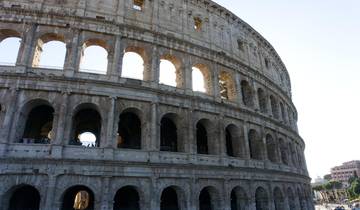
Walk slowly around the Colosseum’s complete perimeter (approximately 527 meters) to appreciate the architectural variations and construction details visible from the outside. Each side reveals different aspects of Roman engineering, restoration work, and the natural aging process that has shaped the monument over nearly two millennia.
The northern facade showcases the building’s original four-story design most completely, with clear examples of the classical orders progression from Doric at ground level through Ionic and Corinthian to the unique fourth-story treatment. This architectural hierarchy demonstrates Roman understanding of visual weight and proportional relationships.
Notice the variation in stone color and texture that reveals different construction phases, earthquake damage, and restoration efforts spanning centuries. The lighter travertine blocks indicate original construction, while darker stones often mark medieval or modern repairs that used different materials or quarry sources.
Architectural Details and Construction Techniques
Examine the sophisticated joinery techniques visible in the exterior stonework. Roman builders used iron clamps and dowels to connect individual blocks without mortar, creating flexible joints that could accommodate thermal expansion and minor ground movement without structural damage.
The exterior arcade system demonstrates Roman mastery of arch construction and load distribution. Each of the 80 arches per level carries specific structural loads while creating the rhythmic visual pattern that makes the enormous building feel harmonious rather than overwhelming.
Look for original Roman numerals above some entrance arches, which helped spectators locate their designated seats in the vast interior. This ancient crowd management system anticipated modern stadium design by centuries, demonstrating sophisticated understanding of human traffic flow and organization.
Tour Stop 3: Via Nicola Salvi Elevated Viewpoint
GPS Coordinates: 41.8905°N, 12.4918°E
Duration: 20-30 minutes
Exit the Colosseo Metro station and turn left, walking along the northern perimeter until you see stone steps leading up to Via Nicola Salvi. This elevated street provides the most famous free photography opportunity in Rome, offering unobstructed views of the Colosseum’s northern facade without tourist crowds blocking your composition.
The raised position reveals architectural details invisible from ground level while providing excellent perspective on the monument’s relationship to the surrounding ancient landscape. From this vantage point, you can observe how the Colosseum dominates its environment while fitting harmoniously into the natural topography.
Multiple positions along the elevated walkway offer varying photographic compositions. The stone wall running along the street creates excellent foreground framing opportunities, while different angles reveal various aspects of the amphitheater’s complex geometry and architectural sophistication.
Photography Techniques and Lighting Considerations
Morning light from this northern position illuminates the Colosseum’s arches beautifully, creating dramatic shadows that emphasize the structure’s three-dimensional form. The contrast between sunlit surfaces and shadowed recesses brings out architectural details that appear flat in other lighting conditions.
Use the stone wall as a foreground element to create depth in your compositions while providing scale reference that helps viewers appreciate the Colosseum’s massive size. Experiment with different focal lengths to isolate specific architectural features or capture the complete structure within its urban context.
Early morning timing provides the best combination of optimal lighting and minimal crowds. Later in the day, this viewpoint becomes crowded with tour groups and photography enthusiasts, making composition and peaceful appreciation more challenging.
Tour Stop 4: Arch of Constantine
GPS Coordinates: 41.8899°N, 12.4906°E
Duration: 15-20 minutes
The Arch of Constantine stands as one of Rome’s best-preserved triumphal monuments and the largest surviving Roman arch. Built in 315 AD to commemorate Constantine’s victory over Maxentius at the Battle of Milvian Bridge, it demonstrates the architectural and artistic traditions that had developed over three centuries of Roman imperial construction.
Examine the arch’s complex relief sculptures, which combine new carvings created specifically for Constantine with older sculptural elements taken from monuments honoring earlier emperors Trajan, Hadrian, and Marcus Aurelius. This sculptural program demonstrates both artistic continuity and the practical reuse of high-quality artwork in Roman construction.
The arch’s position between the Colosseum and Palatine Hill was carefully chosen to maximize its symbolic impact within the landscape of imperial power. Triumphal processions would pass through this arch before entering the Colosseum area, creating dramatic ceremonial transitions between different types of imperial spectacle.
Sculptural Analysis and Historical Interpretation
The relief panels tell specific historical stories through sophisticated artistic techniques that combine realistic portraiture with symbolic representation. Constantine appears in contemporary 4th-century artistic style, while the reused earlier panels demonstrate the classical naturalism of 2nd-century imperial art.
Notice how the arch’s sculptural program connects Constantine to his imperial predecessors while emphasizing his unique achievements. This artistic strategy reinforced political legitimacy while acknowledging the continuity of Roman imperial traditions across different dynasties.
The inscription panels provide historical details about Constantine’s victory and the political context surrounding the arch’s construction. Reading these Latin inscriptions reveals the formal language of imperial propaganda and the specific claims Constantine made about his divine support and military prowess.
Tour Stop 5: Ludus Magnus Archaeological Area
GPS Coordinates: 41.8906°N, 12.4928°E
Duration: 20-25 minutes
Cross Via Labicana to explore the partially excavated remains of the Ludus Magnus, ancient Rome’s largest gladiator training school. This archaeological site provides crucial context for understanding the infrastructure that supported the Colosseum’s entertainments while revealing details about gladiatorial life invisible in popular media representations.
The visible foundations include training arena remains, dormitory areas, and corridor systems that housed and trained the gladiators who fought in the Colosseum. An underground tunnel once connected this facility directly to the amphitheater, allowing gladiators to reach the arena without exposure to crowds or weather.
Information panels around the site include reconstruction drawings that help visitors understand the original scale and function of this complex. The juxtaposition of training school ruins with the Colosseum itself creates powerful visual connections between preparation and performance in ancient entertainment.
Gladiatorial Training and Daily Life
The Ludus Magnus could house approximately 100 gladiators in varying degrees of comfort based on their skill, experience, and value to the training school owners. Star gladiators received better accommodations and training facilities, while novices lived in more austere conditions until they proved their worth.
Training regimens were sophisticated and varied, with different gladiator types requiring specialized skills and equipment. The archaeological remains reveal practice areas for different combat styles, equipment storage facilities, and medical treatment areas that cared for injured fighters.
The economic aspects of gladiatorial training involved substantial investments in housing, feeding, medical care, and equipment for fighters who might die in their first public performance. This business model required careful calculation of costs, training efficiency, and entertainment value.
Tour Stop 6: Oppian Hill Park and Baths of Trajan
GPS Coordinates: 41.8918°N, 12.4945°E
Duration: 45-60 minutes
Climb the gentle slope to Oppian Hill, where extensive parkland preserves the ruins of Trajan’s Baths while providing elevated perspectives on the surrounding ancient city. This area combines archaeological exploration with peaceful green space that offers respite from the intense urban environment around the major monuments.
The Baths of Trajan represent one of ancient Rome’s largest public bathing complexes, demonstrating the engineering sophistication and social importance of public leisure facilities in Roman urban planning. The visible ruins include massive concrete walls, arch foundations, and corridor systems that hint at the original scale of these facilities.
Multiple walking paths wind through the archaeological remains and gardens, each offering different perspectives on both the ancient ruins and the surrounding cityscape. The elevated position provides excellent views of the Colosseum, Roman Forum, and Palatine Hill that help visitors understand the spatial relationships between major ancient sites.
Roman Bathing Culture and Social Functions
Roman public baths served multiple social functions beyond personal hygiene, operating as community centers where citizens conducted business, socialized, exercised, and participated in cultural activities. The Baths of Trajan could accommodate thousands of simultaneous users in facilities that rivaled modern recreational complexes.
The complex engineering required for these facilities included sophisticated heating systems, water supply networks, and waste removal infrastructure that demonstrated Roman mastery of hydraulic technology. Underground furnaces heated air that circulated through wall cavities, creating comfortable bathing environments regardless of weather.
Different sections of the baths catered to various social classes and activity preferences, from hot pools and steam rooms to cold plunges, exercise areas, libraries, and meeting spaces. This social stratification reflected broader Roman society while providing shared public amenities.
Tour Stop 7: Domus Aurea Grounds
GPS Coordinates: 41.8925°N, 12.4955°E
Duration: 25-30 minutes
Continue through the parkland to explore the grounds of Nero’s Domus Aurea (Golden House), where scattered archaeological remains and foundation walls demonstrate the enormous scale of imperial palace construction that once covered much of central Rome.
While the interior of the Domus Aurea requires paid admission and advance booking, the extensive grounds preserve part of the massive estate and provide context for understanding the political and cultural factors that led to this palace’s construction and eventual abandonment.
The contrast between these peaceful gardens and the urban intensity surrounding them helps visitors appreciate the dramatic changes Rome has undergone since ancient times. Walking through Nero’s former gardens while viewing the later Colosseum creates direct connections between different phases of Roman imperial history.
Imperial Palace Architecture and Politics
The Domus Aurea’s original extent covered approximately 125 hectares, including artificial lakes, forests, and agricultural areas that brought countryside landscapes into the heart of Rome. This unprecedented scale reflected both Nero’s personal ambitions and the resources available to Roman emperors at the empire’s peak.
The palace’s construction required demolishing existing neighborhoods and displacing thousands of Roman citizens, creating political tensions that contributed to Nero’s eventual downfall. The public’s resentment of this land appropriation influenced later emperors’ building policies and urban planning approaches.
Architectural innovations developed for the Domus Aurea influenced later Roman construction throughout the empire. The concrete vaulting techniques, decorative programs, and landscape integration pioneered here appeared in subsequent public buildings and private villa construction.
Tour Stop 8: San Clemente Basilica
GPS Coordinates: 41.8883°N, 12.4972°E
Duration: 30-40 minutes
Descend from Oppian Hill toward Via di San Giovanni in Laterano to visit the Basilica of San Clemente, one of Rome’s most fascinating multi-layered archaeological sites. While the underground excavations require paid admission, the upper 12th-century church offers free access to remarkable medieval art and architecture.
The upper basilica features stunning Cosmati marble work, medieval frescoes, and a remarkable apse mosaic depicting the Triumph of the Cross. These artistic elements represent some of Rome’s finest medieval craftsmanship while demonstrating the continuity of Christian artistic traditions in the city.
The church’s peaceful atmosphere provides welcome relief from the bustling tourist areas while offering insights into medieval Roman religious life and artistic achievement. The building’s three distinct historical levels spanning 2,000 years of continuous occupation make it unique among Rome’s churches.
Medieval Art and Architectural Analysis
The intricate floor patterns and pulpit decorations showcase the Cosmati family’s distinctive marble work that combined ancient Roman decorative techniques with medieval Christian symbolism. These geometric patterns create visual harmony while incorporating symbolic elements that reinforced religious teachings.
The medieval frescoes tell biblical stories through sophisticated artistic techniques that balanced realistic representation with symbolic meaning. The artists who created these works were highly skilled professionals who understood both classical artistic traditions and contemporary religious requirements.
The apse mosaic’s complex iconography requires careful examination to understand its theological and artistic significance. The Triumph of the Cross theme connects to broader medieval Christian artistic programs while showcasing local Roman artistic capabilities.
Tour Stop 9: Santi Quattro Coronati
GPS Coordinates: 41.8883°N, 12.4990°E
Duration: 20-25 minutes
Continue to this fortified monastery complex that combines medieval architecture with early Christian history, creating a unique religious site that feels removed from modern Rome despite its central location. The church and courtyards are free to explore and offer insights into medieval monastic life and defensive architecture.
The church’s austere interior contrasts sharply with the ornate decorations of more famous Roman basilicas, but this simplicity creates its own powerful spiritual atmosphere. The wooden ceiling and ancient columns provide examples of medieval construction techniques adapted to Roman architectural traditions.
The monastery’s two courtyards offer peaceful spaces for reflection and photography, surrounded by medieval walls and arches that transport visitors back to Rome’s turbulent medieval period. These courtyards frequently host small art exhibitions and cultural events that add contemporary relevance to the ancient spaces.
Monastic Architecture and Medieval Rome
The complex’s fortified design reflects the political instability that characterized medieval Rome, when religious institutions required military-style defenses to protect their communities and property. The high walls and defensive gates demonstrate the practical challenges facing medieval religious communities.
Monastic architecture balanced spiritual requirements with practical needs for housing, worship, work, and defense. The layout of Santi Quattro Coronati illustrates how medieval architects solved these complex functional requirements while creating spaces that supported contemplative religious life.
The monastery’s survival through centuries of political upheaval demonstrates the institutional continuity that helped preserve Roman cultural traditions during the empire’s collapse and the city’s medieval transformation.
Tour Stop 10: Santo Stefano Rotondo
GPS Coordinates: 41.8877°N, 12.4985°E
Duration: 15-20 minutes
Visit this unique circular church that represents one of Rome’s most distinctive architectural forms, built in the 5th century as an early Christian adaptation of Roman building techniques. The unusual round plan and ancient columns create an atmospheric space unlike any other church in the city.
The church’s interior features a series of disturbing but historically significant frescoes depicting Christian martyrdoms, painted during the Counter-Reformation to inspire religious devotion. While graphic in content, these artworks represent important examples of 16th-century religious art and provide insights into historical Christian experiences.
The peaceful location and unique architecture make Santo Stefano Rotondo an ideal stop for travelers interested in early Christian history and Byzantine architectural influences in Rome. The church’s relative obscurity means you’ll often have the space almost entirely to yourself.
Early Christian Architecture and Symbolism
The circular plan reflects early Christian attempts to create new architectural forms that expressed Christian theological concepts while adapting proven Roman construction techniques. The round shape may symbolize heavenly perfection or represent adaptation of Roman mausoleum architecture to Christian worship.
The integration of ancient columns from earlier Roman buildings demonstrates the practical reuse of materials that characterized early Christian construction in Rome. These spolia (reused elements) created connections between Christian and classical architectural traditions.
The church’s acoustic properties and lighting effects create contemplative atmospheres that support religious worship while showcasing the sophisticated understanding of space and sensory experience that early Christian architects developed.
Tour Stop 11: Celian Hill Overlook
GPS Coordinates: 41.8870°N, 12.4975°E
Duration: 15-20 minutes
Walk to the elevated areas of the Celian Hill for panoramic views that encompass the Colosseum, Palatine Hill, and Circus Maximus valley. This vantage point provides excellent perspective on the topographical relationships between major ancient sites while offering peaceful respite from crowded tourist areas.
The elevated position reveals how ancient Romans used natural landforms to enhance their architectural projects while creating dramatic visual relationships between different types of public buildings. The sight lines from this position demonstrate sophisticated urban planning that maximized both functional efficiency and ceremonial impact.
This location provides excellent photography opportunities during golden hour when warm light illuminates the ancient monuments against the backdrop of modern Rome. The contrast between ancient stones and contemporary urban development illustrates Rome’s character as a living city built upon archaeological foundations.
Urban Planning and Topographical Integration
Roman urban planners understood how to use natural topography to enhance their architectural achievements while creating practical solutions for water drainage, transportation, and defense. The Celian Hill’s position illustrates these planning principles in action.
The relationships visible from this overlook demonstrate how different types of Roman buildings—entertainment venues, residential palaces, religious sites, and commercial areas—were integrated into coherent urban systems that served both practical and ceremonial functions.
Contemporary Rome’s development patterns reflect ongoing negotiation between ancient archaeological remains and modern urban needs. This hillside perspective reveals how the city continues to evolve while respecting its historical foundations.
Tour Stop 12: Return Route via Circus Maximus
GPS Coordinates: 41.8858°N, 12.4857°E
Duration: 30-35 minutes
Complete your walking tour by descending toward the Circus Maximus valley, where you can explore the remains of ancient Rome’s largest entertainment venue while enjoying the contrast between this peaceful park setting and the urban intensity surrounding the Colosseum.
The Circus Maximus provides perspective on the scale of Roman entertainment infrastructure while offering insights into the chariot racing culture that rivaled gladiatorial games in popularity. Although little visible architecture remains, the site’s enormous scale becomes apparent when walking its length.
The return route along Via dei Cerchi and Via di San Gregorio provides street-level perspectives on the monuments you’ve explored from elevated positions, creating connections between different viewpoints while completing the geographical circuit that ties together all tour destinations.
Ancient Entertainment and Urban Planning
The Circus Maximus could accommodate approximately 250,000 spectators, making it larger than any modern sports venue. This enormous capacity reflects both Rome’s massive population and the central importance of public entertainment in maintaining social stability and imperial legitimacy.
Chariot racing culture involved complex social, economic, and political elements that influenced Roman society far beyond mere entertainment. The racing factions (blues, greens, reds, and whites) functioned as unofficial political parties that could influence imperial policy through their massive popular support.
The relationship between the Circus Maximus and other entertainment venues demonstrates how Roman urban planning created districts dedicated to public spectacle while integrating these facilities with residential, commercial, and administrative areas.
Frequently Asked Questions
How long does the complete walking tour take?
The full tour requires 3-4 hours including all stops and moderate exploration time. You can shorten the route by skipping certain stops or extend it by spending more time at sites that particularly interest you. The flexible self-guided format accommodates different paces and preferences.
Is the walking tour suitable for people with mobility limitations?
The tour involves moderate walking on varied surfaces including cobblestones and uneven ancient pavements. Some elevation changes are required for overlook points. Alternative routes can bypass the most challenging sections while maintaining access to major sites.
Do I need to pay admission fees for any stops on the walking tour?
All viewpoints, churches, and external archaeological sites are free to explore. Optional paid entries include the Colosseum interior, San Clemente underground levels, and Domus Aurea tours, but these aren’t necessary for the walking tour experience.
What’s the best time of day to start the walking tour?
Begin around 8:00 AM for optimal lighting, smallest crowds, and comfortable temperatures. Early morning timing also allows completion of outdoor exploration before paid attractions open, maximizing your daily sightseeing efficiency.
Are there restroom facilities along the walking route?
Restroom access is limited at archaeological sites and overlooks. Plan stops at churches (which sometimes have facilities) or cafes along the route. The tour includes several areas with nearby restaurants and bars that allow customer restroom use.
Can I follow this route without a smartphone or GPS?
While GPS coordinates help with navigation, the route follows major landmarks and well-marked streets that can be navigated with a printed map. Key sites are clearly visible and signposted, making smartphone navigation helpful but not essential.
Is the walking tour safe for solo travelers?
The route follows well-traveled areas with good security and regular police presence. Standard urban precautions apply: stay aware of surroundings, secure valuables, and avoid isolated areas. The morning timing recommended for the tour provides additional safety through good visibility and moderate crowds.
What should I bring for the walking tour?
Comfortable walking shoes, water, sun protection, and a portable phone charger are essential. A small backpack can carry supplies and any purchases. Consider bringing snacks, as food options may be limited at some archaeological sites.
Can children enjoy this walking tour?
The tour can be adapted for families with children by shortening the route, adding more frequent breaks, and focusing on the most visually impressive sites. Interactive elements like searching for architectural details can keep children engaged throughout the exploration.
Are there guided audio options to supplement the self-guided tour?
Several smartphone apps provide audio commentary for major sites along the route. These can supplement the written descriptions while maintaining the flexibility of self-guided exploration. Download audio content before starting to avoid data charges.