Nestled in the hills above Cusco, this ancient site captivates travelers with its mysterious stone structures and sweeping views. Often overshadowed by nearby landmarks, it offers a quieter glimpse into Peru’s layered past. Its strategic location suggests it once served as a military outpost or resting place for Inca nobility.
The name “red fortress” comes alive at dusk when sunlight bathes its stones in warm, rusty tones. This unique coloration stems from iron-rich limestone used in construction. Local legends say the site’s glow guided travelers through the Sacred Valley centuries ago.
Scholars believe the complex connects to both Inca and earlier Andean cultures. Its design shares similarities with Sacsayhuaman and Tambomachay, suggesting a network of ceremonial and practical spaces. Visitors today can walk among terraces and chambers that whisper stories of rituals and royal gatherings.
Key Takeaways
- Discover a lesser-known Inca site with breathtaking valley views
- Learn how sunset transforms the stones into a “red fortress”
- Explore connections between Inca and pre-Inca civilizations
- Capture stunning photos during golden hour visits
- Combine your trip with nearby archaeological wonders
- Contact us by filling out the trip planner form, our expert travel advisors will work closely with you to create your tailor-made itinerary (Free Service)
Introduction to the Puka Pukara Archaeological Complex
Perched strategically near Cusco, the stone remnants of this ancient stronghold reveal a fascinating blend of military planning and ceremonial grandeur. Unlike more crowded landmarks, its terraced walls invite quiet contemplation of Andean engineering mastery.
Overview of the Site
This location served multiple roles: a defensive checkpoint, royal lodging, and ceremonial space. Its irregular polygonal stones fit tightly without mortar—a signature of Inca craftsmanship. Terraces cascade down slopes, creating natural vantage points for surveillance.
Archaeologists note water channels and ceremonial baths, suggesting spiritual significance. The layout mirrors celestial patterns seen at Sacsayhuaman, reinforcing connections to cosmic beliefs.
Inca and Pre-Inca Influences
Beneath Inca walls lie traces of older cultures. Carved niches and trapezoidal doorways show styles predating the empire. Scholars argue earlier societies first recognized the site’s strategic value.
Inca builders later enhanced these foundations with advanced dry-stone techniques. Spanish chronicler Pedro Cieza de León noted its importance in controlling trade routes—proof of evolving uses across centuries.
Historical Background and Origins
Long before the rise of the Inca Empire, ancient civilizations recognized the strategic value of this highland location. Early builders shaped local limestone into defensive walls and ceremonial spaces, laying foundations for what would become a multi-era masterpiece.
Pre-Inca Beginnings
Archaeologists identify the Killke culture as the first to develop this site around 1200 CE. These pre-Inca engineers used fieldstones to create terraces and water channels, adapting structures to the terrain’s natural contours. Their work established key functional areas for community gatherings and territorial oversight.
Inca Enhancements and Ruler Influence
Under Emperor Pachacutec’s rule (1438-1471), the site underwent dramatic transformation. Inca builders employed advanced dry-stone masonry, fitting massive polygonal blocks with precision. They expanded storage facilities and watchtowers, turning the location into a vital administrative hub.
The upgraded complex served dual purposes: monitoring Sacred Valley trade routes and hosting royal processions. Recent studies reveal how Inca engineers preserved earlier walls while adding sophisticated drainage systems—a testament to layered construction mastery across generations.
The Significance Behind the Red Fortress Name
The name “Red Fortress” whispers tales of ancient Andean ingenuity, rooted in Quechua language and solar symbolism. Derived from the terms Puka (red) and Pucara (fortress), this title captures both the site’s physical identity and its cultural purpose. Visitors quickly grasp its dual meaning as sunset transforms weathered stones into glowing amber—a daily reminder of its poetic nomenclature.
Iron-rich limestone gives the walls their distinctive rusty hue, intensifying under twilight skies. Scholars suggest this chromatic spectacle served practical and spiritual roles. “The color shift acted as a natural beacon for travelers,” notes historian María Torres, linking the phenomenon to Inca road networks.
Names held deep symbolic weight in Andean cultures, often encoding geographic or cosmic truths. Calling this place a fortress reinforced its role as a protective stronghold, while red evoked connections to earth deities and solar cycles. Such layered meanings reveal how language shaped Inca perceptions of space and power.
Key insights about its title:
- Originates from Quechua words describing color and function
- Sunlight activates the stones’ natural pigments dramatically
- Reflects interconnected Inca concepts of defense and cosmology
This naming tradition transforms the site into a living storybook—one where architecture and etymology together narrate centuries of human adaptation.


Puka Pukara Archaeological Complex – Architecture and Layout
Three imposing barriers define this hillside masterpiece, each revealing distinct engineering purposes. The complex’s design blends defensive practicality with ceremonial elegance, following the land’s natural curves. Builders used local limestone to create zigzagging walls, stepped platforms, and water channels that mirror the surrounding slopes.
The Three Walls Explained
The outermost barrier features jagged angles and narrow entryways, designed to slow approaching forces. Its uneven base merges with bedrock, making breaches nearly impossible. The middle wall showcases smoother surfaces and trapezoidal niches—likely used for ritual offerings or torch placements.
Innermost structures display refined masonry with interlocking stones. These buildings probably housed elite guards or stored ceremonial items. Archaeologists note how each tier’s height increases strategically, offering wider views of approaching travelers.
Terraces, Plazas, and Aqueducts
Broad platforms cascade down the hillside, creating tiered gathering spaces. These terraces stabilized the terrain while hosting public events. A central plaza connects to an intricate aqueduct system that channeled spring water to ritual baths and storage pools.
Engineers embedded drainage channels within walls to prevent erosion during rains. This fusion of natural topography and human ingenuity demonstrates how ancient builders turned challenges into functional artistry. Their work remains a testament to sustainable design principles still admired today.
Exploring the Walls: First, Second, and Third Levels
Three distinct tiers of stone barriers rise from the hillside, each revealing new layers of strategic design. Master builders crafted these levels to serve different purposes while harmonizing with the rugged landscape. The walls’ progression from winding foundations to elevated platforms showcases evolving engineering priorities.
Detailed Features of the First Wall
The first wall snakes across the terrain like a protective serpent. Its irregular, zigzagging path follows natural rock formations, blending defense with environmental adaptation. Builders used medium-sized stones with rough surfaces, creating friction that stabilized the structure without mortar.
This base layer features narrow passageways and staggered entry points. These design choices forced approaching visitors into single-file lines, enhancing security. Archaeologists note how the wall’s curves also channeled rainwater away from critical areas.
Insights into the Higher Levels
Above the foundational barrier, the second wall introduces broader platforms and smoother surfaces. Here, larger stones display precise cutting techniques, with interlocking edges that withstand earthquakes. Terraced walkways connect ceremonial spaces to watchtowers overlooking trade routes.
The uppermost level features flat plazas framed by polished limestone blocks. These open areas likely hosted gatherings or astronomical observations. “The elevation shift transforms functionality,” explains architect Luis Gómez. “Lower walls controlled access, while upper spaces facilitated community activities.”
| Level | Key Features | Primary Purpose |
|---|---|---|
| First | Zigzag layout, rough stones | Defense & crowd control |
| Second | Interlocking blocks, terraces | Security & transition |
| Third | Polished limestone plazas | Ceremonies & observation |
Builders selected specific stones for each tier based on function. Crushed gravel foundations beneath the walls prevented shifting during wet seasons. This multi-layered approach created a resilient system that has endured centuries of Andean weather patterns.
Hidden Features and Intriguing Curiosities
Beneath the visible terraces and plazas lies a web of mysteries that fuels archaeological debates. While most visitors admire the location’s sweeping views, its true allure emerges in whispers of concealed passageways and forgotten chambers.

Chancanas and Underground Tunnels
Local legends speak of a chincana—a hidden tunnel system linking this site to Tambomachay, a ceremonial spring complex one mile away. Though unconfirmed, ground-penetrating radar surveys reveal hollow spaces beneath the western walls. Some researchers propose these voids could represent an ancient option for discreet travel between Inca sites.
The location of potential tunnel entrances adds to the intrigue. Narrow openings near storage rooms align with Inca engineering patterns for secret routes. “These features suggest dual purposes,” notes archaeologist Carla Mendoza. “What appears decorative might conceal functional passageways.”
| Confirmed Features | Theoretical Possibilities | Strategic Purpose |
|---|---|---|
| Subsurface chambers | Connection to Tambomachay | Royal escape routes |
| Concealed niches | Ceremonial pathways | Ritual privacy |
| Reinforced walls | Hidden storage areas | Resource protection |
Modern explorers face limited entrance options to investigate these theories, as preservation laws restrict excavation. Yet the mere possibility transforms every cracked stone into a potential clue. Visitors today can ponder these enigmas while walking the same paths where Inca guards once stood watch.
The site’s hidden dimensions remind us that ancient engineering often prioritized both practicality and poetry. Whether myth or reality, these curiosities deepen the location’s magnetic pull—inviting travelers to look beyond the obvious.
Visitor Information: Tickets, Hours, and Climate
Planning a visit to this storied destination requires understanding access details and seasonal patterns. Smart preparation ensures travelers maximize their experience while respecting preservation guidelines.
Your Gateway to Andean History
The Cusco Tourist Ticket serves as your key to unlocking multiple archaeological treasures. Two options exist:
- Full Ticket (BTCI): $47 USD for 10 days, covering 16 sites including Sacsayhuaman and Tambomachay
- Partial Ticket (Circuit III): $27 USD for 2 days, granting access to 4 locations near Cusco
Both options allow entry to the complex and can be purchased online or at authorized offices. “This system helps manage visitor flow while supporting conservation,” explains travel expert Marco Quispe.
| Ticket Type | Price | Included Sites |
|---|---|---|
| Full | $47 | 16 cultural locations |
| Partial | $27 | 4 nearby complexes |
Timing Your Exploration
Gates open daily from 8:00 AM to 5:30 PM. Consider these tips for optimal visits:
- Arrive before 10 AM for cooler temperatures and softer light
- Avoid midday crowds (11 AM – 2 PM) during peak season
- Sunset visits showcase the stones’ color changes but bring layers
The highland climate mirrors Cusco’s patterns—dry mornings give way to afternoon showers from November to March. June through August offers clearer skies but colder nights. Sturdy shoes and sun protection prove essential year-round.
Transportation and Access Options
Reaching this historic hillside destination from Cusco offers travelers multiple pathways to discovery. Whether prioritizing convenience or cultural immersion, visitors can tailor their journey through smart planning. The route follows ancient pathways while accommodating modern comforts.
Public Transit and Taxi Services
Budget-conscious explorers often choose colectivos—shared vans departing from Señor del Huerto station on Huerto Street. These leave when full (6-8 passengers) and cost under $1 USD. Drivers drop passengers at the site’s entrance road, requiring a 10-minute uphill walk.
Taxis provide door-to-door service for about $10-$15 USD roundtrip. “Always confirm fares before entering vehicles,” advises local guide Ana Quispe. Many drivers offer waiting time packages for visitors combining multiple nearby sites.
- Guided city tours bundle access with transportation, often including Sacsayhuaman and Tambomachay
- Private tours feature bilingual guides and flexible timing
- Group excursions reduce costs while maintaining comfort
The scenic 30-minute journey from city Cusco winds along the original Inca road. This stone-paved route once connected ceremonial sites, offering glimpses of terraced valleys and grazing alpacas. Modern asphalt now covers parts of the path, blending history with contemporary travel.
| Option | Cost Range | Travel Time |
|---|---|---|
| Colectivo | $0.50-$1 | 40 mins |
| Taxi | $10-$15 | 25 mins |
| Tour Group | $25-$60 | Half-day |
Morning departures avoid afternoon rains common from November to March. Those driving rental cars will find limited parking near the site—arrive before 9 AM for best availability. Each transportation choice reveals different facets of Andean life, turning the journey into part of the adventure.
Exploring the Inca Road and Surrounding Ruins
Winding through the Andean highlands, the Inca Road links travelers to a network of historical wonders. This ancient highway once connected ceremonial centers, military outposts, and trade hubs across the empire. Modern explorers can follow its stone-paved remnants to discover neighboring sites that share cultural and architectural DNA.
Nearby Attractions such as Tambomachay and Sacsayhuaman
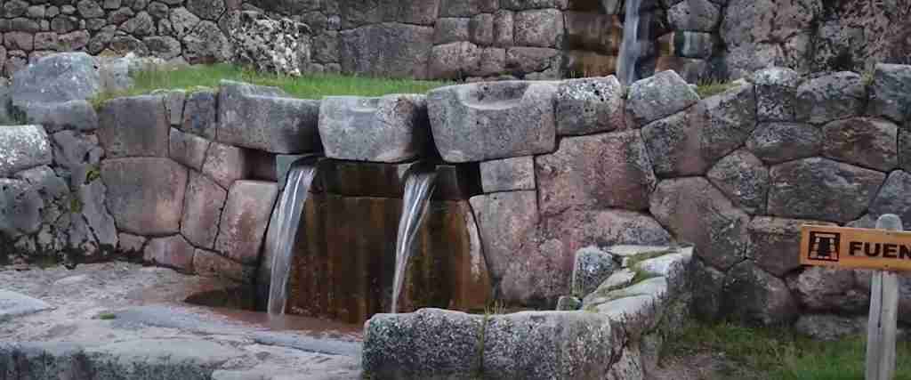
Just two miles from the site lies Tambomachay, known for its intricate water channels and ritual baths. The precision-cut stones mirror techniques seen in nearby structures, suggesting shared engineering knowledge. “These locations formed a spiritual circuit,” explains local guide Rosa Mendez. “Nobles traveled between them during festivals.”
Sacsayhuaman impresses with its massive zigzagging walls, a testament to Inca military prowess. Together, these landmarks create a living museum of Andean innovation. Many tours bundle visits to maximize historical context.
Guided Tours and Self-Exploration Options
Expert-led excursions unlock hidden stories through trained eyes. Guides decode symbolic carvings and explain celestial alignments missed by casual observers. Self-guided adventurers enjoy flexible pacing but risk overlooking subtle details.
| Features | Guided Tours | Self-Exploration |
|---|---|---|
| Historical Insights | In-depth explanations | Informational plaques |
| Access | Priority entry | Standard admission |
| Flexibility | Fixed itinerary | Personalized routes |
Extended itineraries often include Machu Picchu, letting travelers trace the empire’s expansion. Whether joining group tours or hiking solo, the area rewards those who explore beyond surface-level sights.
Experiencing the Site’s Natural Landscape and Climate
High-altitude vistas frame this historic location, where dramatic temperature shifts paint a living portrait of Andean ecology. Rolling hills dotted with native ichu grass surround the stone structures, creating a striking contrast between human craftsmanship and untamed wilderness. Visitors often marvel at how the terrain’s natural contours mirror the site’s architectural lines.
Daylight plays a vital role in revealing the site’s hidden details. Morning sun illuminates intricate carvings on terrace walls, while afternoon shadows emphasize the strategic placement of watchtowers. “The stones seem to shift with the sun’s movement,” observes local guide Elena Ríos. “It’s like watching history awaken.”
Ancient water channels still trace the slopes, their gentle flow adding rhythmic tranquility to the atmosphere. These engineering marvels once directed spring water to ceremonial baths and agricultural terraces. Today, their presence connects visitors to the site’s functional beauty.
| Time of Day | Lighting Conditions | Temperature Range |
|---|---|---|
| Early Morning | Soft, directional light | 45-55°F |
| Midday | Harsh shadows | 65-70°F |
| Late Afternoon | Golden hour glow | 50-60°F |
Days here typically feel warm under intense mountain sun, while nights plunge temperatures by 20-25 degrees. This sharp contrast heightens the sense of timelessness, as if the stones themselves remember centuries of frost and sunlight. Smart layering ensures comfort during exploration.
For immersive experiences, arrive near dawn or dusk. These windows offer comfortable temperatures and lighting that transforms ordinary walks into sensory journeys. The interplay of water, stone, and shifting skies creates moments where past and present harmonize effortlessly.
Practical Tips for a Successful Visit
Exploring high-altitude historical sites requires smart preparation to balance comfort with discovery. The terrain’s steep slopes and unpredictable weather demand thoughtful planning. These strategies help travelers focus on cultural immersion rather than logistical challenges.
What to Bring and Wear
Mountain weather shifts rapidly—layering proves essential. Start with moisture-wicking base layers, add insulating fleece, and finish with wind-resistant outerwear. Sturdy hiking shoes with ankle support prevent slips on uneven stone paths.
Pack these essentials in a lightweight daypack:
- Reusable water bottle (aim for 2 liters minimum)
- High-energy snacks like nuts or coca leaves
- Passport or ID for ticket verification
- Portable oxygen canister for altitude adjustment
Navigation and Safety Tips
Marked trails help visitors navigate safely, but smartphone GPS provides extra security. Download offline maps before arrival—cellular service remains spotty. “Always inform someone about your itinerary,” advises trekking guide Miguel Soto.
| Altitude Challenge | Preventive Measure | Emergency Response |
|---|---|---|
| Headaches/Nausea | Drink coca tea | Descend 500 meters |
| Sunburn | SPF 50+ reapplied hourly | Aloe vera gel |
| Dehydration | Sip water every 20 minutes | Electrolyte tablets |
Tourists should acclimate in Cusco for 48 hours before visiting. Avoid alcohol and heavy meals during adjustment periods. Travel insurance covering high-altitude emergencies offers peace of mind for adventurous explorers.
Conclusion
Standing at the crossroads of history and natural wonder, this ancient stronghold offers more than stone walls—it reveals humanity’s enduring dialogue with landscape. Its terraced architecture and sunset-lit stones serve as testaments to engineering brilliance, while panoramic views connect visitors to the Sacred Valley’s timeless spirit.
Travelers leave enriched by layers of cultural insight. The site’s strategic placement near Cusco underscores its role as both guardian and gateway. From ceremonial plazas to hidden water channels, every feature whispers tales of empires shaped by earth and sky.
For those seeking authentic encounters, the city remains a living museum. Modern streets echo with traditions preserved through centuries. Visitors gain not just memories, but new perspectives on how civilizations adapt to their environments.
Let this landmark inspire your next journey. Walk where warriors and nobles once stood. Feel the pulse of history beneath your feet. As dusk paints the stones crimson, you’ll understand why this destination remains Cusco’s captivating secret—a bridge between past wonders and present-day discovery.
