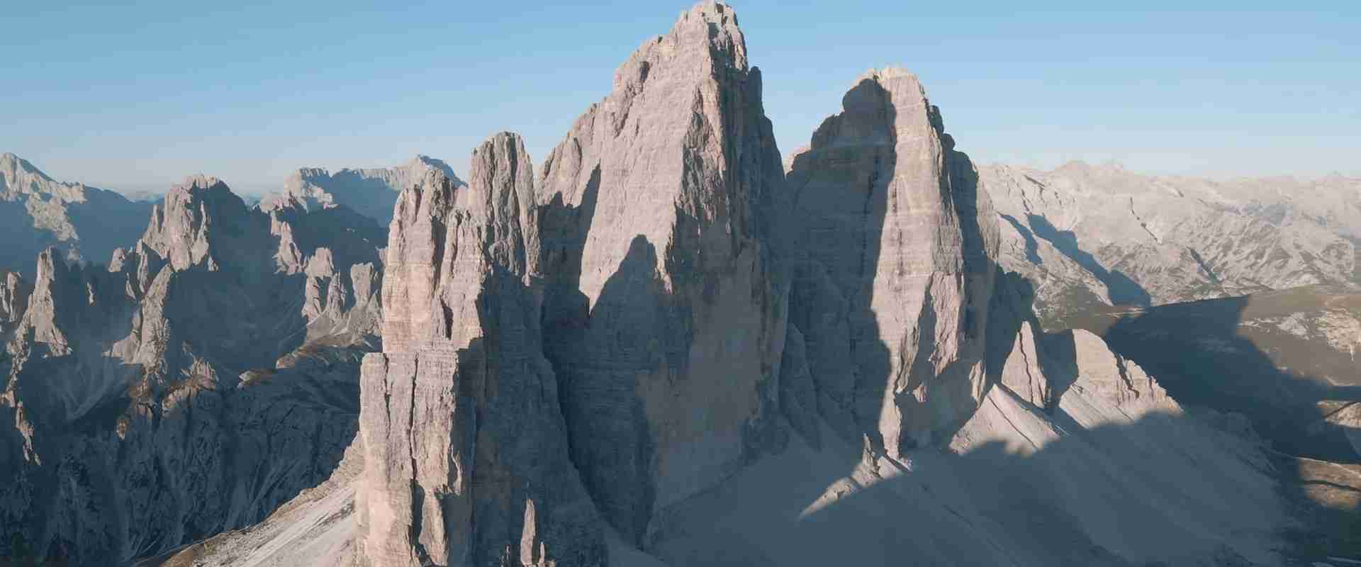
Dolomites Geology & Formation Guide: Rock Structures & Natural Architecture
The Dolomites represent one of Earth’s most spectacular examples of carbonate mountain geology, preserving 250 million years of geological history in visible rock layers. These mountains differ fundamentally from other limestone ranges through their distinctive rock composition, erosion patterns, and structural characteristics.
Key Takeaways
- Dolomite rock forms through magnesium replacement of calcium in limestone, creating a harder, more erosion-resistant mineral that produces the characteristic vertical walls and sharp peaks
- The pale gray-white color results from light scattering through the crystalline dolomite structure, with minimal impurities creating the distinctive appearance that differentiates these peaks from surrounding ranges
- Triassic coral reefs built between 252-201 million years ago created the foundation limestone layers visible today as alternating bands in cliff faces
- Glacial erosion carved U-shaped valleys, cirques, and arêtes during Pleistocene ice ages, removing softer rock layers and accentuating vertical dolomite walls
- The enrosadira phenomenon occurs when low-angle sunlight at dawn and dusk preferentially reflects red wavelengths off dolomite crystal surfaces, creating the famous pink-orange glow
- Nine distinct mountain groups recognized by UNESCO demonstrate exceptional geological diversity including platform carbonates, basin deposits, volcanic features, and metamorphic zones
Introduction: Understanding Dolomite Geology
Understanding Dolomites geology requires examining multiple processes: ancient tropical reef formation, chemical transformation of limestone to dolomite, tectonic uplift creating mountain structures, and glacial erosion carving final topographic details. Each process left distinctive signatures visible in modern landscapes.
The term “dolomite” refers both to the mineral calcium magnesium carbonate [CaMg(CO3)2] and the rock type composed predominantly of this mineral. French mineralogist Déodat de Dolomieu identified this compound in 1791 when analyzing pale limestone samples from Tyrolean mountains. Laboratory analysis revealed unusual chemical composition distinguishing dolomite from pure calcium carbonate limestone. The mineral exhibits greater hardness, different cleavage patterns, and distinctive weathering behavior compared to calcite comprising standard limestone. These physical properties explain why dolomite mountains maintain vertical faces while limestone mountains typically erode into more rounded profiles.
Geological significance extends beyond mineral composition to encompass exceptional preservation of ancient environments and Earth history processes. The Dolomites contain outstanding examples of Triassic tropical reef ecosystems, demonstrating marine life recovery after the Permian-Triassic extinction event. Exposed stratigraphic sequences display clear transitions between different depositional environments including deep basins, reef margins, and shallow lagoons. Volcanic layers interbedded with carbonate rocks record periods of igneous activity. These diverse rock types create natural laboratories for understanding sedimentary processes, reef ecology, volcanic island systems, and mountain building dynamics.
People Also Ask About Dolomites Geology
What makes dolomite rock different from limestone?
Dolomite rock differs from limestone through chemical composition and physical properties. Limestone consists of calcium carbonate (CaCO3) with calcite as the primary mineral. Dolomite contains calcium magnesium carbonate [CaMg(CO3)2] with dolomite mineral as the main component. This chemical difference creates distinct physical behaviors. Dolomite exhibits greater hardness measuring 3.5-4 on the Mohs scale compared to calcite at 3. The hardness difference affects weathering patterns, with dolomite maintaining sharp edges and vertical faces while calcite limestone erodes into smoother, more rounded forms.
Acid reactivity distinguishes the two rock types. Calcite limestone fizzes vigorously when cold dilute hydrochloric acid contacts the surface as carbonic acid rapidly dissolves calcium carbonate. Dolomite shows minimal reaction to cold acid, requiring powdered samples or warmed acid for visible effervescence. This difference reflects slower dissolution kinetics of the dolomite mineral. The reduced acid reactivity makes dolomite more resistant to chemical weathering in natural environments where slightly acidic rainwater slowly dissolves carbonate rocks. This resistance contributes to preservation of vertical walls in the Dolomites compared to limestone ranges where solution weathering creates gentler slopes.
Crystal structure differs between calcite and dolomite minerals. Calcite forms rhombohedral crystals with perfect cleavage in three directions producing characteristic rhomb-shaped fragments. Dolomite crystals exhibit similar rhombohedral form but with slightly different angles reflecting the ordered arrangement of calcium and magnesium atoms within the crystal lattice. This structural difference affects optical properties with dolomite showing distinctive curved twin lamellae under polarized light microscopy. Geologists use these optical characteristics to distinguish dolomite from limestone in thin section analysis.
How did tropical reefs form in what is now northern Italy?
Continental drift carried the future Dolomites region through different climate zones over geological time. During the Triassic Period (252-201 million years ago), the area occupied equatorial latitudes approximately 10-20 degrees north of the ancient equator. This tropical position resulted from the configuration of the Pangaea supercontinent and the location of the Tethys Ocean, the precursor to the Mediterranean Sea. Warm ocean temperatures of 25-30°C and shallow water depths of 20-200 meters created ideal conditions for coral reef development similar to modern Caribbean and Indo-Pacific reefs.
The Tethys Ocean spread between the northern margin of Africa (part of Gondwana) and the southern margin of Eurasia (part of Laurasia) as Pangaea began fragmenting. Shallow carbonate platforms developed along continental margins and around volcanic islands dotting the ocean. These platforms supported diverse marine communities including scleractinian corals, sponges, calcareous algae, and countless invertebrate species. The organisms secreted calcium carbonate skeletons forming reef structures. Over millions of years, continuous growth and sediment accumulation built carbonate sequences hundreds to thousands of meters thick.
Plate tectonics subsequently moved this region northward. The collision between Africa and Eurasia beginning approximately 65 million years ago closed the Tethys Ocean and initiated Alpine mountain building. This collision compressed and uplifted former ocean floor deposits including the Triassic reefs. The movement carried these tropical reef rocks to current mid-latitude position at approximately 46°N latitude. Modern Dolomites climate bears no resemblance to Triassic tropical conditions, yet the rock record preserves clear evidence of ancient equatorial environments through fossil assemblages, sedimentary structures, and carbonate fabrics characteristic of warm-water reef systems.
Why are the Dolomites so pale compared to other mountains?
The distinctive pale gray-white color of dolomite rock results from its crystalline structure and minimal impurities. Pure dolomite contains only calcium, magnesium, carbon, and oxygen arranged in an ordered crystal lattice. This simple composition lacks the iron oxides, clays, and organic matter that darken most sedimentary rocks. Light entering the rock scatters through the crystalline structure rather than being absorbed, reflecting back to observers as the characteristic pale tone. The fine-grained texture of many dolomite layers enhances this effect through multiple scattering events before light exits the rock surface.
The dolomitization process removes impurities present in original limestone. When magnesium-rich fluids percolate through limestone, chemical reactions replace calcium with magnesium while expelling impurities into surrounding pore fluids. This purification creates cleaner, paler rock compared to original limestone which often contains clay minerals, iron compounds, and organic carbon. The degree of dolomitization varies across the range with completely dolomitized rocks showing the palest colors while partially dolomitized limestone retains darker tones. This variation creates subtle color banding visible on many peaks.
Weathering processes maintain pale colors on dolomite surfaces. Chemical weathering of dolomite produces minimal staining compared to limestone. Iron-rich limestone weathers to yellow, brown, or red tones as iron compounds oxidize on exposed surfaces. Dolomite’s low iron content prevents such staining. Physical weathering through freeze-thaw cycles continuously fractures surface rock exposing fresh pale surfaces. This natural cleaning process maintains the bright appearance even on ancient rock faces. The combination of inherent paleness and continuous renewal through weathering creates the striking light-colored peaks that define Dolomites scenery.
What causes the pink glow at sunrise and sunset?
The enrosadira phenomenon transforms pale Dolomite peaks into glowing pink and orange towers during sunrise and sunset through selective wavelength reflection. This optical effect occurs when sunlight strikes mountain faces at low angles characteristic of dawn and dusk. The atmosphere scatters short-wavelength blue light away from the light path through Rayleigh scattering, leaving longer-wavelength red and orange light to reach the mountains. The crystalline dolomite surface preferentially reflects these warm wavelengths creating intense pink-orange illumination lasting 10-30 minutes.
The dolomite crystal structure enhances this effect compared to other rock types. The ordered arrangement of calcium and magnesium atoms in the dolomite lattice creates regular crystal faces that reflect light coherently. This coherent reflection intensifies color compared to irregular surfaces that scatter light diffusely. The fine grain size in many dolomite beds increases surface area enhancing reflection intensity. Variations in crystal size and orientation across different rock layers create subtle color gradations visible during peak enrosadira moments.
Atmospheric conditions influence enrosadira intensity and duration. Clear skies with dry air produce the most dramatic displays as minimal atmospheric moisture reduces light scattering. Thin high clouds sometimes enhance colors through additional scattering that increases the proportion of red wavelengths reaching peaks. Thick clouds or haze diminish the effect by blocking sunlight before it reaches mountains. Seasonal variations affect enrosadira viewing with winter’s lower sun angles and clearer air creating particularly intense displays. The phenomenon represents pure optical physics requiring no special rock properties beyond the reflective pale surfaces and vertical orientations exposing faces to low-angle sunlight.
Extended multi-day tours – 5+ days
Featured The Dolomites Multi-Day Tour Packages

3 days
The Dolomites 3-Day Discovery Tour
- ✓ Comprehensive The Dolomites experience
- ✓ Expert local guides included
- ✓ All accommodation included
- ✓ Transportation provided
5 days
The Dolomites 5-Day Highlights Experience
- ✓ Comprehensive The Dolomites experience
- ✓ Expert local guides included
- ✓ All accommodation included
- ✓ Transportation provided

7 days
The Dolomites 7-Day Cultural Journey
- ✓ Comprehensive The Dolomites experience
- ✓ Expert local guides included
- ✓ All accommodation included
- ✓ Transportation provided
10 days
The Dolomites 10-Day Complete Adventure
- ✓ Comprehensive The Dolomites experience
- ✓ Expert local guides included
- ✓ All accommodation included
- ✓ Transportation provided
Multi-day tour packages powered by TourRadar. Prices and availability subject to change.
Triassic Reef Formation and Deposition
The Triassic Period witnessed exceptional marine ecosystem development in the Tethys Ocean as life recovered from the catastrophic Permian-Triassic extinction event. This extinction eliminated approximately 90% of marine species 252 million years ago. Recovery proceeded gradually through the Early and Middle Triassic as surviving lineages diversified filling vacant ecological niches. By the Middle Triassic (approximately 240 million years ago), marine ecosystems achieved complexity rivaling pre-extinction conditions. Scleractinian corals emerged as dominant reef builders establishing patterns persisting to modern oceans.
The Dolomites region occupied a complex marine setting during Triassic reef development. Volcanic islands rose from the Tethys Ocean creating irregular bathymetry with shallow platforms surrounding islands and deep basins between them. This varied topography supported diverse depositional environments. Shallow platforms with water depths under 50 meters developed extensive coral reefs. Reef margins dropped steeply into basin depths of 200-500 meters. Basin floors accumulated fine carbonate muds and occasional volcanic ash layers. This environmental mosaic created the varied rock types visible today as different formations and lithologies.
The Cassian Formation preserves the most diverse Middle Triassic reef ecosystem known globally. Deposited approximately 235-230 million years ago, this formation contains over 500 fossil species representing complete reef community structure. Scleractinian corals formed framework structures providing three-dimensional habitat complexity. Sponges contributed additional framework elements. Brachiopods, bivalves, gastropods, crinoids, and echinoids populated reef surfaces and crevices. Ammonites and nautiloids swam in surrounding waters. The exceptional preservation and diversity make Cassian beds internationally significant for understanding Triassic marine life and ecosystem structure.
The Schlern Formation (Sciliar) represents a different depositional setting: protected lagoons behind reef barriers. These calm-water environments accumulated fine carbonate sediments including lime mud and skeletal debris transported from reefs. The resulting rock shows fine lamination and limited fossil diversity compared to reef facies. The massive Schlern Dolomite forms prominent peaks including the Sciliar massif, demonstrating how lagoon deposits achieve thicknesses of 1,000+ meters through subsidence and continuous sediment accumulation. The fine grain size in lagoonal dolomite creates some of the smoothest, palest rock surfaces in the range.
Dolomitization Process and Chemistry
Dolomitization transforms calcium carbonate limestone into calcium magnesium carbonate dolomite through ion exchange reactions. This process requires magnesium-rich fluids percolating through porous limestone replacing calcium ions with magnesium while maintaining the overall carbonate framework. The reaction proceeds: 2CaCO3 + Mg2+ → CaMg(CO3)2 + Ca2+. This simplified equation represents complex multi-stage processes involving partial dissolution, ion exchange, and reprecipitation. Complete transformation of limestone to dolomite requires sustained fluid flow delivering sufficient magnesium and removing excess calcium.
The magnesium source for Dolomites dolomitization remains debated among geologists. Several mechanisms potentially supplied magnesium-rich fluids. Evaporation of shallow marine waters concentrates magnesium creating brines that percolate through underlying limestone. Mixing of fresh groundwater and seawater creates chemical disequilibrium driving dolomitization. Hydrothermal fluids associated with volcanism or tectonic activity transport magnesium from deep sources. Bacterial activity modifies pore water chemistry promoting dolomite precipitation. The Dolomites likely experienced multiple dolomitization episodes using different mechanisms at various times during and after reef deposition.
Dolomitization timing influences rock properties and distribution patterns. Syndepositional dolomitization occurs during or shortly after sediment deposition while pore spaces remain water-filled and connected. This early dolomitization produces fine-grained, well-ordered dolomite crystals throughout the rock mass. Burial dolomitization happens after sediment burial as compaction and heating drive fluid flow through rock formations. This later dolomitization often produces coarser crystals and more irregular distribution. Hydrothermal dolomitization associated with tectonic events creates localized zones of dolomite around fluid pathways. The Dolomites exhibit evidence for all three timing scenarios with different formations showing different dolomitization styles.
Incomplete dolomitization creates the mixed carbonate rocks common throughout the Dolomites. Many formations contain both limestone and dolomite in varying proportions. This mixing produces mechanical property variations affecting erosion resistance and cliff formation. Completely dolomitized units form the most prominent vertical walls. Partially dolomitized rocks erode to intermediate slope angles. Limestone-rich layers weather more rapidly creating recesses and platforms. This differential erosion based on dolomitization degree generates the complex topography characteristic of the range with multiple cliff tiers, benches, and recesses on individual peaks.
Volcanic Interlude and Igneous Features
Volcanic activity punctuated Triassic carbonate deposition leaving distinctive layers visible throughout the Dolomites. These volcanic episodes occurred when magma broke through the Tethys Ocean floor creating submarine and subaerial volcanoes. The volcanic rocks appear as dark gray to reddish layers alternating with pale carbonate beds. The most prominent volcanic unit, the Buchenstein Formation, consists of basaltic lava flows, volcanic ash (tuff), and volcaniclastic sediments deposited approximately 240 million years ago. These layers create striking color contrasts visible on many peaks including distinctive red and green bands on the Sella massif.
The Athesian Volcanic Platform underlying the Dolomites formed earlier during Permian time (approximately 280-270 million years ago). This extensive volcanic complex consists of rhyolitic and dacitic igneous rocks known as Bozener Quarzporphyr (Bolzano Quartz Porphyry). These rocks appear in valley bottoms and lower slopes throughout the western Dolomites. The porphyritic texture features large quartz and feldspar crystals set in a fine-grained matrix. This volcanic basement influenced subsequent Triassic reef development by creating irregular topography controlling water depth and circulation patterns.
Volcanic ash layers within carbonate sequences provide valuable chronological markers for correlation between sections. Ash contains zircon crystals suitable for uranium-lead dating yielding precise ages for volcanic events. These dates establish timescales for carbonate accumulation rates and reef development stages. Volcanic ash layers also preserve exceptional fossils through rapid burial. The ashfall killed organisms instantly and buried them before decay or scavenger disturbance. Such preservation creates “snapshot” assemblages showing community structure at single moments rather than time-averaged accumulations.
The chemical composition of volcanic rocks varies across the Dolomites reflecting different magma sources and tectonic settings. Basaltic lavas represent mantle-derived magmas rising through extensional fractures in the Tethys Ocean floor. Rhyolitic and dacitic rocks derive from crustal melting or fractional crystallization of basaltic parents. This compositional variety indicates complex tectonic processes during Triassic time including both extension creating ocean floor spreading and compression related to subduction zones along the Tethys margins. The volcanic rocks provide tectonic context for the reefs that grew on and around volcanic edifices.
Structural Geology and Tectonic Evolution
Alpine orogeny transformed horizontal Triassic sediments into vertical mountain structures through compressional tectonics. The collision between Africa and Eurasia beginning approximately 65 million years ago generated enormous compressive forces propagating through Mediterranean rocks. These forces folded, faulted, and uplifted the Triassic reef sequences creating the modern Dolomites. Understanding structural evolution requires examining fold patterns, fault systems, and uplift mechanisms that converted ocean floor to alpine peaks.
The Dolomites exhibit distinctive structural style compared to other Alpine regions. Rather than intense folding and metamorphism characteristic of the High Alps, the Dolomites preserve relatively intact sedimentary sequences with limited deformation. Geologists term this “thin-skinned” tectonics where deformation occurs in sedimentary cover rocks detached from basement. Thrust faults carried rock sheets northward over underlying units. The Valsugana thrust represents a major fault transporting Triassic carbonates over younger Jurassic and Cretaceous rocks. This stacking increased rock thickness and surface elevation without severe internal deformation.
Block faulting created the characteristic Dolomite massifs where massive carbonate platforms broke into fault-bounded blocks. The Sella Group exemplifies this structure: a relatively flat-topped plateau surrounded by vertical walls coinciding with fault planes. The Marmolada and Civetta massifs show similar patterns. These blocks tilted slightly during faulting exposing different stratigraphic levels. The Catinaccio (Rosengarten) exhibits east-dipping strata visible as slanted beds in cliff faces. This tilting reflects listric faulting where fault planes curve from steep at the surface to shallow at depth.
Jointing patterns control detailed erosion and topography. Joints are fractures without displacement cutting through rock masses. Multiple joint sets intersect creating rectangular block patterns. Freeze-thaw weathering exploits joints loosening blocks that eventually fall creating vertical cliffs and scree slopes. Major peaks like the Tre Cime di Lavaredo consist of massive blocks bounded by joint planes. The spacing between joints influences peak shapes: closely-spaced joints create pinnacles and spires, widely-spaced joints produce broad walls and towers. Geologists map joint patterns to predict rockfall hazards and understand topographic evolution.
Glacial Erosion and Topographic Development
Pleistocene glaciation (2.6 million to 11,700 years ago) carved final topographic details into the Dolomites. Multiple ice ages covered the Alps with extensive glaciers transforming tectonic structures into the dramatic landscape visible today. Ice erosion removed hundreds of meters of rock from valleys while sharpening ridges and peaks. Understanding glacial processes explains modern valley shapes, peak configurations, and surface features throughout the range.
Valley glaciers created U-shaped cross-sections replacing the V-shaped profiles characteristic of river valleys. Glacial ice flows plastically under its own weight eroding valley floors and walls through abrasion and quarrying. Abrasion occurs when rock fragments embedded in glacial ice grind against bedrock wearing it away like sandpaper. Quarrying happens when glacial meltwater penetrates rock fractures, freezes, and plucks out blocks. These processes widen valley floors and steepen walls creating the characteristic U-shape. Val Gardena, Val Badia, and Val di Fassa display perfect glacial U-profiles visible in cross-valley views.
Glacial erosion varies with ice thickness and velocity creating differential erosion patterns. Main valley glaciers carrying thick ice from extensive accumulation areas erode deeply creating overdeepened basins. Modern lakes including Lago di Braies, Lago di Misurina, and Lago di Carezza occupy such glacially-scoured depressions. Tributary glaciers erode less deeply than trunk glaciers due to smaller ice volume. When glaciers retreat, tributaries remain as hanging valleys with streams cascading down valley walls. The Pisciadù waterfall in Alta Badia drops 30 meters from a hanging valley to the main Val Badia floor demonstrating this erosion contrast.
Cirque erosion carved amphitheater-shaped hollows at mountain flanks. Cirque glaciers rotated as they flowed, with ice moving downslope along the floor while back-rotating at the headwall. This rotation pattern enhanced headwall erosion through quarrying creating steep, often overhanging cliffs. Multiple cirques eroding from different directions created sharp ridges (arêtes) between them. Where three or more cirques meet, they form horn peaks with distinctive pyramidal shapes. The Sass de Putia (Peitlerkofel) demonstrates classic horn morphology with cirques carved into three sides creating three sharp arêtes meeting at the summit.
Erosion Patterns and Weathering Processes
Weathering processes continuously modify Dolomite surfaces creating distinctive erosion patterns. Both physical and chemical weathering contribute to landscape evolution with their relative importance varying by rock type, exposure, and elevation. Understanding these processes explains surface textures, rockfall patterns, and topographic details from individual peaks to regional-scale features.
Freeze-thaw weathering dominates physical weathering in the Dolomites. Water enters rock fractures during daytime or summer warmth. When temperatures drop below freezing, water expands 9% upon converting to ice. This expansion generates enormous pressures exceeding rock tensile strength, forcing fractures wider. Repeated freeze-thaw cycles progressively enlarge fractures until rock blocks separate and fall. The process proceeds most effectively where temperatures oscillate around 0°C causing frequent freeze-thaw cycles. Spring and autumn provide optimal conditions with daytime temperatures above freezing and nighttime freezing. High-altitude areas experience year-round freeze-thaw contributing to accelerated weathering at exposed summits.
Chemical weathering of dolomite proceeds through slow dissolution by slightly acidic rainwater. Atmospheric carbon dioxide dissolves in rainwater creating weak carbonic acid. This acid reacts with dolomite mineral slowly dissolving calcium and magnesium while releasing carbon dioxide. The reaction: CaMg(CO3)2 + 2H2CO3 → Ca2+ + Mg2+ + 4HCO3-. While slower than calcite dissolution, the process gradually removes material from exposed surfaces. Dissolution along fracture walls creates widened joints and solution grooves. Karst features including small caves, sinkholes, and solution pockets develop where favorable conditions enhance dissolution. The Altopiano della Paganella displays typical karst topography with numerous sinkholes and disappearing streams.
Biological weathering contributes to rock breakdown through several mechanisms. Lichens growing on rock surfaces produce organic acids that dissolve minerals. Root growth in fractures exerts pressure separating rock. Burrowing organisms including marmots excavate soil exposing fresh rock to weathering. While individually minor, biological processes accumulate over time contributing measurably to erosion especially at lower elevations where biological activity concentrates. The vegetation limit around 2,500-2,700 meters marks the transition from biologically-influenced weathering below to purely physical-chemical processes above.
Scree Slopes and Talus Accumulation
Scree slopes flanking cliffs throughout the Dolomites accumulate through continuous rockfall from weathering cliffs. When freeze-thaw or other weathering processes dislodge rock blocks, they fall under gravity accumulating at cliff bases. The accumulated debris forms talus slopes with characteristic angles around 35-40 degrees representing the angle of repose for angular rock fragments. Fresh rockfall events continuously resurface scree slopes explaining why they show minimal vegetation even at low elevations where plants could grow.
Scree characteristics vary with source rock properties. Massive dolomite cliffs produce large boulder-size talus with blocks ranging from 0.5 to several meters diameter. Bedded formations with thin layers generate smaller fragments creating finer scree. The grain size distribution affects slope stability and vegetation establishment. Boulder talus remains mobile with frequent rockfall events preventing plant colonization. Fine scree stabilizes faster allowing pioneer plants to establish in sheltered areas. Over centuries, vegetation expansion gradually stabilizes scree converting it to vegetated slopes.
Scree slopes preserve climate signals through their distribution and activity patterns. Active scree lacking vegetation indicates ongoing rockfall from weathering cliffs. The geographic distribution of active scree reflects current freeze-thaw intensity with more active slopes on north-facing aspects where freeze-thaw cycles occur most frequently. Stabilized scree with vegetation cover represents past activity when climate conditions favored more intensive weathering. Comparing active and stabilized scree distributions helps geologists reconstruct past climate variations and predict future landscape evolution under changing climate conditions.
Distinctive Formations and Mountain Groups
Tre Cime di Lavaredo
The Tre Cime di Lavaredo (Drei Zinnen) stand as the most iconic Dolomite peaks demonstrating exceptional vertical relief. Three massive towers rise from a common base with vertical north faces dropping 500-600 meters. The peaks consist of Dolomia Principale formation, a massive well-dolomitized Triassic platform carbonate. The extreme verticality results from vertical jointing combined with resistant dolomite lithology. Weathering exploited joint planes on the west, east, and north sides isolating the three towers while the south side remains connected as a continuous ridge.
Geological mapping reveals the structural control on Tre Cime topography. The peaks sit atop a thrust fault that transported Triassic carbonates over younger Jurassic rocks. The thrust created the elevated position while faults bounding the massif steepened the flanks. The massive character of the Dolomia Principale with thick beds lacking internal weak layers enables the extreme verticality. Thinner-bedded formations visible in nearby peaks like Monte Paterno create stepped profiles rather than sheer walls, demonstrating lithologic control on topographic form.
Glacial erosion enhanced Tre Cime relief through cirque development on the north side. A Pleistocene glacier occupied the north-facing amphitheater carving away rock and creating the overhanging headwall. The south side lacking glacial erosion maintains gentler slopes reflecting structural dip. This contrast between glacially-steepened north faces and structurally-controlled south slopes appears throughout the Dolomites creating asymmetric peak profiles with dramatic north walls and accessible south routes.
Sella Group
The Sella Group presents a massive platform-like massif rising to 3,152 meters at Piz Boè. The relatively flat summit plateau contrasts with surrounding peaks demonstrating different geological controls. The Sella consists primarily of Schlern Dolomite, a thick massive formation deposited in a lagoon setting behind reef barriers. The fine-grained homogeneous character creates cliff-forming properties while the horizontal bedding preserves original depositional geometry with minimal tectonic tilting.
Block faulting created the Sella’s distinctive morphology. Major faults bound the massif on all sides creating near-vertical walls coinciding with fault planes. The Sella represents a relatively intact block that rose during Alpine compression while surrounding blocks subsided or eroded away. The flat top preserves the original platform surface demonstrating minimal internal deformation. This structural coherence distinguishes the Sella from more complexly deformed areas elsewhere in the range.
Volcanic layers visible on Sella faces provide additional geological interest. Dark gray basaltic rocks and red-colored oxidized tuffs alternate with pale dolomite creating striking banding visible from surrounding valleys. These volcanic units represent submarine eruptions during Triassic reef growth. The interbedding demonstrates that reef development and volcanism occurred simultaneously with volcanoes erupting through living reefs. Modern Sella preserves this relationship allowing geologists to study ancient volcanic-reef interactions rarely preserved so clearly.
Marmolada
Marmolada rises to 3,343 meters as the highest Dolomite peak. The southern face presents 1,000+ meters of sheer vertical rock consisting of massive Marmolada Limestone, a Late Triassic platform carbonate. While less completely dolomitized than other formations, this limestone maintains cliff-forming character through thick massive bedding and structural position. The summit plateau supports the Marmolada Glacier, the largest glacier remnant in the Dolomites demonstrating ongoing ice presence despite general Holocene glacier recession.
The Marmolada structure reflects complex tectonic history. The massif represents a tilted fault block with gently north-dipping strata visible in the glacier area and steep to vertical beds forming the south wall. The south face coincides with a major thrust fault creating the extreme relief. Folding affects eastern portions of the massif where beds curve showing compressional deformation. This structural complexity contrasts with the relatively simple block structure of the Sella demonstrating variable deformation intensity across the Dolomites.
Glacial features dominate Marmolada’s northern slopes where the glacier occupies a broad cirque. Moraines dating from Little Ice Age advances (16th-19th centuries) mark former ice extent hundreds of meters beyond current glacier margins. Older Pleistocene moraines extend kilometers downvalley recording maximum ice age extents. These deposits allow glaciologists to reconstruct climate history and glacier responses to temperature changes. Modern glacier monitoring documents rapid recent recession raising concerns about complete disappearance within decades if warming trends continue.
Pale di San Martino
The Pale di San Martino group forms extensive pale-colored plateaus and towers in the southern Dolomites. The area contains exceptional examples of multiple carbonate formations including reefal, lagoonal, and basinal facies spanning Early to Late Triassic. The Rosetta Formation preserves one of the Dolomites’ thickest and most complete stratigraphic sections allowing detailed study of depositional history spanning tens of millions of years.
Karst features develop extensively across Pale di San Martino plateaus. Numerous sinkholes, caves, and underground drainage systems form through carbonate dissolution. The altopiano (plateau) surface captures precipitation that percolates underground emerging in valley springs. Some caves extend hundreds of meters documenting complex underground drainage networks. Karst research in the Pale di San Martino contributes to understanding carbonate hydrogeology with applications to water resource management and cave system evolution.
Fossil assemblages in the Pale di San Martino include exceptional ammonite collections from basinal deposits. Deep-water facies between carbonate platforms accumulated fine sediments containing abundant ammonites, the extinct cephalopod relatives of modern nautilus. These fossils enable precise biostratigraphic dating allowing correlation of Dolomite sequences with global standards. Paleontologists continue discovering new species in Pale di San Martino outcrops contributing to knowledge of Triassic marine life evolution.
UNESCO World Heritage Geological Significance
UNESCO designation recognized the Dolomites’ outstanding universal value through Criterion viii: “contain superlative natural phenomena or areas of exceptional natural beauty and aesthetic importance.” Geological significance formed the core justification emphasizing three primary values. First, the Dolomites represent premier examples of carbonate platform and reef systems preserving Triassic marine ecosystems at exceptional quality and completeness. Second, the mountains demonstrate textbook examples of dolomitization processes with visible transitions from limestone to dolomite allowing study of this important geochemical transformation. Third, the scenic landscape displays exceptional beauty resulting from unique rock properties and erosion patterns creating vertical topography unmatched globally.
The designation encompasses nine separate mountain systems rather than the entire range. This selective approach concentrated protection on areas demonstrating exceptional geological features. Each system exhibits distinctive characteristics contributing to overall diversity. The Brenta Dolomites show intensive tectonic deformation. The Marmolada preserves maximum elevation and glacial features. The Pale di San Martino contains exceptional stratigraphic completeness. This diversity within a relatively small geographic area enhances scientific value by enabling comparative studies of different geological processes and histories.
International geological significance extends to understanding fundamental Earth processes. The Dolomites contribute to knowledge about carbonate depositional systems with applications to petroleum geology where carbonate reservoirs hold major oil and gas accumulations. Understanding ancient reef ecology informs conservation of modern reef systems facing climate change threats. Studying mountain building processes in the Dolomites enhances understanding of active mountain belts including the Himalayas and Andes. The range serves as a natural laboratory accessible to geologists worldwide supporting ongoing research advancing Earth science knowledge.
FAQ Section: Geological Questions
Can you find fossils in the Dolomites?
The Dolomites contain abundant fossils, particularly in Middle Triassic formations. The Cassian Formation near Cortina preserves over 500 fossil species including corals, bivalves, gastropods, ammonites, brachiopods, crinoids, and echinoids. Weathered scree slopes concentrate fossils as erosion removes surrounding rock releasing fossils to accumulate downslope. However, fossil collecting faces legal restrictions. Italian law protects fossils prohibiting removal without permits. Visitors can observe fossils in situ and photograph them but should not collect specimens. Museums in Cortina, Predazzo, and other towns display fossil collections allowing detailed study without field collecting.
Why do the Dolomites have such vertical cliffs?
Vertical cliffs result from the intersection of multiple factors. Dolomite rock’s hardness and erosion resistance allow near-vertical faces to persist over geological time. Massive bedding in platform carbonates creates thick competent units supporting verticality. Vertical jointing provides fracture planes along which cliffs form through weathering. Tectonic faulting created steep to vertical fault planes that control cliff locations. Glacial erosion steepened valley walls and carved cirque headwalls. These factors combine creating the characteristic Dolomite topography with vertical walls rising hundreds of meters from talus slopes. Similar limestone mountains lacking complete dolomitization erode to gentler slopes demonstrating dolomite rock’s unique properties in maintaining verticality.
Are the Dolomites still growing or eroding?
The Dolomites experience both ongoing uplift and erosion simultaneously. Tectonic uplift continues as the African-Eurasian collision persists, though at slower rates than during peak Alpine orogeny. GPS measurements detect continuing uplift averaging 1-2 millimeters annually in parts of the Eastern Alps. However, erosion rates exceed uplift rates meaning net elevation decreases over time. Erosion removes an estimated 0.5-1.0 millimeters of rock annually through physical weathering, chemical dissolution, and mass wasting. At current rates, erosion will reduce Dolomite elevations significantly over millions of years. However, the range will persist indefinitely at geological timescales as erosion proceeds slowly compared to total rock mass.
What is the oldest rock in the Dolomites?
The oldest rocks exposed in the Dolomites are Permian volcanic rocks of the Bozener Quarzporphyr (Bolzano Quartz Porphyry) formation dating to approximately 280-270 million years ago. These rhyolitic volcanic rocks form the basement underlying Triassic carbonates and appear in valley bottoms throughout the western Dolomites. Below these volcanic rocks lie even older Paleozoic metamorphic rocks including gneisses and schists visible in some deeply-eroded valleys. These metamorphic rocks formed during earlier mountain-building events predating Alpine orogeny. However, the characteristic pale dolomite peaks forming the range’s identity date to the Triassic Period (252-201 million years ago), making them significantly younger than basement rocks though still ancient by human timescales.
How fast did the coral reefs grow?
Triassic reef growth rates remain difficult to measure precisely but probably resembled modern coral reef growth. Modern tropical reefs accumulate vertically at rates of 1-10 millimeters per year depending on species composition, water conditions, and other factors. Framework-building corals grow faster than overall reef accumulation as spaces between coral branches fill slowly with sediment and cement. Applying modern analogues to Triassic reefs suggests accumulation rates of 0.5-5 millimeters annually. At these rates, building a 500-meter-thick reef platform requires 100,000 to 1,000,000 years, consistent with geological evidence showing platform development spanning millions of years of Triassic time. Variations in growth rate reflect changing conditions including water depth, temperature, nutrient availability, and sedimentation rates affecting coral vitality.
Why are some areas limestone and others dolomite?
The distribution of limestone versus dolomite reflects complex patterns of fluid flow during and after reef deposition. Dolomitization requires sustained flow of magnesium-rich fluids through permeable limestone. High-porosity reef frameworks with interconnected pore spaces dolomitize preferentially as fluids percolate easily. Low-porosity fine-grained lagoonal carbonates resist dolomitization remaining as limestone. Proximity to fault zones influences dolomitization as faults provide conduits for fluid circulation. Some formations show complete dolomitization while adjacent units remain pure limestone despite similar original compositions. This pattern reflects timing and location of fluid flow during multiple dolomitization episodes. The resulting mosaic of rock types creates variable erosion resistance controlling topographic details with fully dolomitized areas forming prominent cliffs and limestone areas eroding to recesses.
Can earthquakes occur in the Dolomites?
Earthquakes occur in the Dolomites region though less frequently and at lower magnitude than in highly active zones like central Italy or the Friuli area. Historical records document damaging earthquakes including the 1348 Villach earthquake and the 1976 Friuli earthquake affecting the eastern Dolomites. Ongoing tectonic activity as Africa continues pushing northward generates stress accumulation and occasional release through seismic events. Modern seismic monitoring detects numerous small earthquakes (magnitude less than 3.0) occurring regularly throughout the Alps. Most remain unfelt by people though sensitive instruments record them. Earthquake hazard assessment considers the Dolomites a moderate seismicity region where significant earthquakes occur rarely (recurrence intervals of centuries) but remain possible requiring building codes accounting for seismic loads.
What will happen to the Dolomites with climate change?
Climate change impacts the Dolomites through multiple pathways with visible effects already underway. Glacier recession accelerates with most small glaciers disappearing within decades. The Marmolada Glacier lost approximately 30% of volume since 2000. Continued warming threatens complete glacier elimination by 2050-2100. Permafrost thaw destabilizes rock faces increasing rockfall frequency particularly affecting high-altitude routes and infrastructure. Vegetation zones shift upward as temperatures rise with tree lines advancing and alpine meadow areas shrinking. Precipitation pattern changes affect water availability for communities and ecosystems. Tourism patterns shift as winter snow reliability decreases at lower elevations while summer heat drives visitors to higher, cooler areas. These changes require adaptive management strategies including enhanced hazard monitoring, infrastructure relocation, ecosystem protection, and tourism model adjustments. The geological structure remains stable over human timescales, but surface conditions and living systems face significant climate-driven changes requiring careful management to preserve the outstanding values that earned UNESCO recognition.
How do geologists map the Dolomites?
Geological mapping combines traditional field methods with modern technology. Geologists traverse areas on foot examining rock outcrops, measuring structural attitudes with compasses and clinometers, collecting samples for laboratory analysis, and recording observations on topographic base maps. Digital tools including GPS devices record precise locations while tablets with georeferenced base maps facilitate real-time digital mapping. Aerial photographs and satellite imagery supplement field observations revealing large-scale patterns invisible at ground level. Drones equipped with high-resolution cameras produce detailed imagery of inaccessible cliffs enabling remote structural analysis. Laboratory work includes petrographic microscopy examining rock thin sections, geochemical analysis determining compositions, and paleontological study identifying fossils. Integration of field and laboratory data produces geological maps showing rock unit distributions, structural features, and age relationships. Modern Dolomites mapping builds on over 150 years of previous work revising and refining understanding through new data and improved techniques. Detailed maps enable resource management, hazard assessment, and scientific research supporting both conservation and sustainable use.
What makes the Dolomites different from the rest of the Alps?
The Dolomites differ from the rest of the Alps through rock composition, structural style, and topographic expression. While most Alpine rocks consist of metamorphic gneisses and schists or granitic intrusions, the Dolomites preserve relatively unmetamorphosed sedimentary sequences dominated by carbonates. This compositional difference creates distinctive pale colors contrasting with the gray granites and dark metamorphics of the High Alps. Structurally, the Dolomites experienced thin-skinned deformation preserving original sedimentary features while the High Alps underwent intense metamorphism obliterating original textures. Topographically, the Dolomites display vertical towers and walls characteristic of resistant carbonate rocks while the High Alps show more rounded forms reflecting metamorphic rock properties. These differences result from the Dolomites’ position at the southern edge of Alpine deformation where compression remained moderate compared to the intense convergence affecting the central Alps. This geological setting preserved a unique window into Triassic Earth history unavailable in more highly metamorphosed Alpine regions making the Dolomites exceptionally valuable for Earth science research.