
Doi Inthanon National Park: Thailand’s Highest Peak Guide
Doi Inthanon National Park protects Thailand’s highest mountain at 2,565 meters elevation, offering cool mountain climates, spectacular waterfalls, cloud forests, and diverse ecosystems just 70 kilometers from Chiang Mai. Known as “The Roof of Thailand,” the park provides accessible high-altitude experiences including summit drives, nature trails, Royal Pagodas, and cultural encounters with Karen and Hmong hill tribe communities.
Key Takeaways
- Thailand’s highest point at 2,565 meters above sea level is accessible by vehicle, with no technical hiking required to reach the summit marker
- Park entrance costs 300 baht for foreign adults and 150 baht for children aged 3-14, with additional fees of 30 baht for cars or 20 baht for motorcycles
- Four major waterfalls include Mae Ya (250-260 meters cascading height), Wachirathan (70-80 meters powerful falls), Mae Klang (near entrance), and Siriphum (50-meter twin streams)
- Kew Mae Pan Nature Trail offers 2.5-kilometer circular hiking with panoramic mountain views but closes June through October for forest recovery and requires local guide accompaniment
- Royal Twin Pagodas dedicated to the King and Queen charge separate 100 baht entrance fee and feature stunning gardens with mountain valley backdrops
- Cool season months from November through February provide optimal visiting conditions with clear skies, comfortable temperatures, and blooming flora
People Also Ask About Doi Inthanon National Park
What is the elevation of Doi Inthanon and can you drive to the summit?
Doi Inthanon reaches 2,565 meters above sea level, making it Thailand’s highest mountain and the southernmost point of the Himalayan mountain range. Visitors can drive directly to the summit parking area via paved Highway 1009, with no technical hiking required to reach the highest point marker. The final approach involves a short walk of a few hundred meters from the parking lot to the actual summit monument honoring King Inthawichayanon. This accessibility distinguishes Doi Inthanon from many high-altitude peaks requiring multi-day treks or mountaineering skills. The drive from Chiang Mai city at 387 meters elevation to the summit traverses more than 2,000 meters of altitude gain over approximately 70 kilometers, creating dramatic climate and ecosystem changes along the route. Drivers should expect winding mountain roads with steep grades and sharp curves requiring careful navigation, particularly during rainy conditions when roads become slippery.
How much does entrance to Doi Inthanon National Park cost?
Entrance fees for Doi Inthanon National Park are 300 baht for foreign adults and 150 baht for children aged 3 to 14, with Thai nationals paying reduced rates of 60 baht for adults and 30 baht for children. Vehicle fees add 30 baht for cars or 20 baht for motorcycles to the per-person admission charges. The Royal Twin Pagodas (Phra Mahathat Naphamethanidon and Naphapholphumisiri) require separate admission of 100 baht per person, as this attraction is not managed by the national park service despite being located within park boundaries. Entrance tickets remain valid throughout the day for all park attractions except the Twin Pagodas, allowing visitors to exit and re-enter freely at waterfalls and trailheads. The park accepts cash payment only at entrance gates, with no credit card facilities available. Visitors should retain tickets, as checkpoint staff may request them at multiple locations throughout the park.
What are the best hiking trails in Doi Inthanon National Park?
The Kew Mae Pan Nature Trail represents Doi Inthanon’s premier hiking experience, covering 2.5 kilometers in a circular route near the summit with panoramic mountain views, diverse vegetation zones, and opportunities to observe endemic bird species. This moderate-difficulty trail requires hiring a local guide and closes annually from June through October for forest recovery. The Ang Ka Nature Trail provides easier accessibility with a 400-meter boardwalk through cloud forest vegetation near the summit, ideal for observing moss-covered trees, ferns, and unique high-altitude flora without significant physical demands. The Pha Dok Sieo Nature Trail passes through rice terraces and Karen hill tribe villages before reaching a waterfall, combining natural scenery with cultural experiences. Each trail showcases different park ecosystems: Kew Mae Pan features rhododendrons and mountain vistas, Ang Ka demonstrates cloud forest characteristics, and Pha Dok Sieo illustrates agricultural landscapes. Trail difficulty ranges from easy (Ang Ka boardwalk) to moderate (Kew Mae Pan with elevation changes), with hiking times from 30 minutes to 2.5 hours.
When is the best time to visit Doi Inthanon National Park?
November through February represents optimal visiting conditions for Doi Inthanon National Park, offering cool temperatures ranging 10 to 20 degrees Celsius at higher elevations, minimal rainfall, clear skies for mountain views and sunrise photography, and blooming Siamese cherry blossoms in December through January. This cool dry season coincides with peak tourism, requiring advance planning for accommodations and resulting in larger crowds at popular attractions. March through May brings hotter temperatures exceeding 30 degrees Celsius at midday but fewer tourists and vibrant plant life, suitable for visitors comfortable with tropical heat. June through October monsoon season delivers frequent afternoon rainfall, muddy trail conditions, but spectacular waterfall flows at maximum volume and lush green landscapes. The Kew Mae Pan Nature Trail closes during monsoon months for forest recovery, limiting hiking options. Birdwatchers should target March through July breeding season when species diversity peaks and migratory birds remain present.
Extended multi-day tours – 5+ days
Featured Chiang Mai Multi-Day Tour Packages
3 days
Chiang Mai 3-Day Discovery Tour
- ✓ Comprehensive Chiang Mai experience
- ✓ Expert local guides included
- ✓ All accommodation included
- ✓ Transportation provided

5 days
Chiang Mai 5-Day Highlights Experience
- ✓ Comprehensive Chiang Mai experience
- ✓ Expert local guides included
- ✓ All accommodation included
- ✓ Transportation provided
7 days
Chiang Mai 7-Day Cultural Journey
- ✓ Comprehensive Chiang Mai experience
- ✓ Expert local guides included
- ✓ All accommodation included
- ✓ Transportation provided

10 days
Chiang Mai 10-Day Complete Adventure
- ✓ Comprehensive Chiang Mai experience
- ✓ Expert local guides included
- ✓ All accommodation included
- ✓ Transportation provided
Multi-day tour packages powered by TourRadar. Prices and availability subject to change.
Introduction
Doi Inthanon National Park encompasses 482 square kilometers of mountainous terrain in Chiang Mai Province, protecting Thailand’s highest peak and the diverse ecosystems spanning elevations from 800 to 2,565 meters above sea level. The park forms part of the Himalayan mountain range’s southern terminus, creating unique ecological conditions where tropical lowland forests transition through temperate cloud forests to high-altitude vegetation zones found nowhere else in Thailand. This elevational diversity supports exceptional biodiversity including over 500 recorded bird species (the highest count of any Thai protected area), 65 mammal species, and thousands of plant species ranging from tropical orchids to temperate rhododendrons.
The mountain was originally known as Doi Luang (Great Mountain) or Doi Ang Ga, serving as sacred space for local Karen and Hmong communities who have inhabited the region for centuries. King Inthawichayanon, one of Chiang Mai’s last independent rulers before Thai unification, pioneered forest conservation in northern Thailand during the late 1800s, recognizing deforestation threats from logging and agricultural expansion. Upon his death, his remains were placed on the mountain summit according to his wishes that the forests be preserved for future generations. The peak was renamed Doi Inthanon in his honor, and the surrounding area was designated Thailand’s first national park in 1954, later expanded to current boundaries in 1972 and 1974.
Today Doi Inthanon attracts nature enthusiasts, birdwatchers, photographers, and cultural travelers seeking accessible high-altitude experiences without technical mountaineering requirements. The paved road to the summit enables visitors of all fitness levels to experience dramatic altitude changes, observe diverse ecosystems, and enjoy cool mountain climates contrasting with Thailand’s typical tropical heat. Popular attractions include spectacular waterfalls fed by mountain streams, the iconic Royal Twin Pagodas offering panoramic valley views, multiple nature trails through cloud forests and rhododendron groves, Karen and Hmong hill tribe villages maintaining traditional lifestyles, and the Royal Project agricultural research stations demonstrating sustainable farming alternatives to opium cultivation.
The park’s proximity to Chiang Mai (approximately 1.5 to 2 hours driving time) makes it feasible as a day trip for travelers based in the city, though overnight stays in nearby villages or park accommodations allow for sunrise viewing from the summit, extended hiking, and deeper cultural experiences with hill tribe communities. The combination of natural beauty, cultural significance, accessibility, and cool weather year-round has established Doi Inthanon as one of northern Thailand’s most popular national parks, attracting both domestic Thai visitors seeking respite from lowland heat and international tourists experiencing Thailand’s montane environments.
Geography and Elevation of Thailand’s Highest Mountain
Doi Inthanon rises to 2,565 meters above sea level, establishing it as Thailand’s highest mountain and earning the park its “Roof of Thailand” nickname. The peak stands as the southernmost extension of the Himalayan mountain range, marking where this massive geological formation terminates before descending into Southeast Asian lowlands. The mountain’s prominence creates dramatic topographical variation within relatively compact geographical area, with elevations ranging from 800 meters in lowland valleys to the 2,565-meter summit over distances of just a few kilometers.
This extreme elevational gradient produces distinct vegetation zones stratified by altitude. Lower elevations between 800 and 1,200 meters support mixed deciduous forests with teak and dipterocarp species adapted to seasonal rainfall patterns and warm temperatures. Mid-elevations from 1,200 to 1,800 meters transition to dry evergreen and pine forests where temperate species begin appearing alongside tropical vegetation. Upper elevations above 1,800 meters feature moist evergreen cloud forests characterized by constant humidity from condensing moisture, moss-covered trees, epiphytic orchids and ferns, and sphagnum bog formations in poorly-drained areas. The summit region above 2,400 meters supports specialized high-altitude vegetation including dwarf shrubs, rhododendrons blooming in cooler months, and grasslands where trees cannot survive the cold, wind, and thin soils.
The park’s location within the Ping River watershed creates numerous streams and rivers flowing down mountain slopes, feeding the Mae Wang, Mae Klang, Mae Ya, Mae Hoi, and Mae Chaem river systems. These watercourses carve steep valleys and gorges through the mountainous terrain, creating the spectacular waterfalls that rank among the park’s primary attractions. The abundant water resources support lush vegetation year-round despite seasonal rainfall variation, while the steep topography concentrates water flow into powerful cascades during both wet and dry seasons.
Climate varies dramatically with elevation, creating comfortable cool conditions at higher altitudes even during Thailand’s hot season when lowland areas experience oppressive heat. Summit temperatures range from near-freezing on winter mornings to maximum 20 degrees Celsius during warmest months, requiring visitors to bring warm clothing regardless of season. Mid-elevation areas experience moderate temperatures from 15 to 25 degrees Celsius, while lower park elevations remain warmer with typical northern Thai climate patterns. Humidity remains high year-round at upper elevations due to cloud forest conditions, with morning fog and mist common regardless of season. Rainfall follows monsoon patterns with May through October receiving substantial precipitation (particularly July through September peak months), while November through April brings drier conditions with occasional light rain.
The geological substrate consists primarily of granite and metamorphic rocks formed through mountain-building processes, with weathering creating the park’s characteristic steep slopes, rocky outcrops, and boulder-strewn stream channels. Soil development varies by elevation and slope angle, from thin rocky soils on steep upper slopes to deeper accumulated soils in valley bottoms where organic matter accumulates. The combination of steep terrain, high rainfall, and soil characteristics creates natural landslide and erosion risks, particularly during intense monsoon storms when saturated soils lose stability on steep slopes.
Human settlement within the park includes approximately 4,500 people living in Karen and Hmong hill tribe villages scattered across various elevations. These communities have inhabited the region for generations, practicing traditional agriculture including rice cultivation in terraced paddies, vegetable farming, and historically opium poppy cultivation before Royal Project interventions promoted alternative crops. The presence of permanent villages within park boundaries creates ongoing management challenges balancing conservation goals with community livelihood needs and cultural preservation.
Major Waterfalls Throughout the Park
Mae Ya Waterfall: Spectacular Cascading Height
Mae Ya Waterfall cascades 250 to 260 meters down a series of tiers creating Thailand’s tallest waterfall by cumulative height, spreading up to 100 meters wide across the rock face during peak flow periods. Located in the park’s southern section approximately 17 kilometers southwest of the main entrance checkpoint, Mae Ya requires separate navigation from the primary summit road but remains accessible via paved roads suitable for all vehicles. The waterfall’s impressive vertical drop and substantial width during monsoon season have earned it recognition as potentially Thailand’s most beautiful waterfall, though this distinction remains debated among waterfall enthusiasts familiar with other spectacular Thai cascades.
The waterfall flows year-round with volume varying seasonally. Dry season flow from November through April remains consistent enough to create spectacular viewing, though the cascade narrows and individual tiers become more distinct as water volume decreases. Monsoon season from June through October brings maximum flow when the waterfall spreads across its full width, generating tremendous spray and mist visible from considerable distances. The powerful flow during wet months creates swimming opportunities in pools at the waterfall’s base, while dry season allows safer wading and closer approach to the cascade.
Mae Ya sits at its own entrance checkpoint where visitors present park admission tickets purchased at the main entrance or buy tickets valid for the entire national park. The waterfall area includes parking, picnic facilities with tables and benches, and a 700-meter hiking trail ascending alongside the falls to upper viewpoints. The hike gains significant elevation over relatively short distance, requiring moderate fitness but rewarding effort with panoramic views of the full cascade from various angles. Lower viewpoints near the parking area provide accessible viewing for visitors unable or unwilling to hike uphill.
The waterfall’s remote location in the park’s southern reaches means fewer visitors compared to roadside attractions like Wachirathan, creating opportunities for peaceful enjoyment particularly during weekday visits. However, this distance also requires dedicated travel time, with round-trip drives from the main park entrance consuming 45 minutes to one hour. Visitors planning comprehensive park exploration should budget adequate time for Mae Ya rather than attempting quick stops, as the scale and beauty merit extended viewing and photography.
Wachirathan Waterfall: Powerful Central Attraction
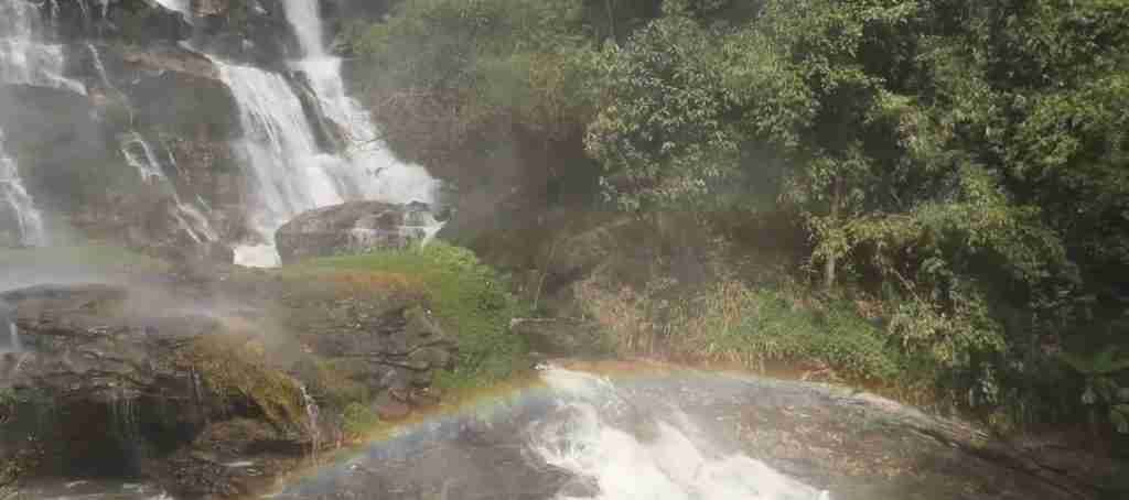
Wachirathan Waterfall plunges 70 to 80 meters in a concentrated powerful flow, creating the park’s most forceful cascade with spray and mist visible from hundreds of meters away. Located along Highway 1009 approximately midway between the park entrance and summit, Wachirathan offers convenient roadside access with large parking area, multiple food vendors, restaurants, and easy paved walking paths to viewing platforms. The waterfall’s central location and accessibility make it the park’s most visited cascade, popular with both tour groups and independent travelers.
The waterfall forms where the Huay Mae Klang River drops over a cliff formation, concentrating substantial water volume into a relatively narrow channel creating immense force and spray. Even during dry season when water levels decline throughout the park, Wachirathan maintains impressive flow generating the characteristic mist cloud and rainbows in afternoon sunlight. Monsoon season transforms the falls into a thundering wall of water with spray reaching viewing platforms and creating muddy, slippery conditions on surrounding trails.
A paved loop trail allows viewing from multiple angles, though the main platform directly facing the falls provides the classic photographic perspective. The trail’s lower sections near the waterfall’s base experience constant spray creating naturally muddy conditions and requiring careful footing. Visitors should expect to get wet from mist even standing at designated viewpoints, with waterproof phone cases recommended for photography. Swimming is prohibited due to the dangerous currents and force of the falling water, though the cooling spray provides refreshing respite from hiking and driving.
The facility infrastructure at Wachirathan includes restrooms, multiple food stalls selling Thai dishes and snacks, ice cream vendors, and covered seating areas. This commercial development makes Wachirathan suitable for extended rest stops including meals, particularly appealing to families with children who can explore the accessible trails while adults relax at restaurants. The combination of spectacular natural beauty and convenient amenities explains the waterfall’s popularity despite crowds, as visitors can enjoy the cascade comfortably without extensive hiking or primitive facilities.
Mae Klang Waterfall: Entrance Gateway
Mae Klang Waterfall sits near the park entrance along Highway 1009, serving as many visitors’ first waterfall encounter when driving toward the summit. The falls drop approximately 100 meters in distinct tiers, creating picturesque cascades suitable for family photography and picnicking. The waterfall operates under separate entrance checkpoint where visitors show park admission tickets or purchase tickets valid throughout Doi Inthanon, making Mae Klang accessible even to visitors focusing on lower-elevation attractions without driving to the summit.
The waterfall area features extensive picnic facilities including covered tables and benches along the river below the falls, grassy areas for spreading blankets, and shade trees providing comfortable outdoor dining spaces. These amenities make Mae Klang particularly popular with Thai domestic tourists and Chiang Mai residents seeking weekend picnic destinations within easy driving distance of the city. The picnic focus creates different atmosphere compared to other park waterfalls, with families gathering for extended meals rather than brief photo stops.
Swimming opportunities exist in pools below the falls, though conditions vary seasonally and visitors should assess water depth and current strength before entering. The river’s rocky bottom and potential for slippery stones require water shoes or secure footwear rather than bare feet. Children should remain under close adult supervision due to varying depths and currents. The swimming possibilities combined with picnic infrastructure create full-day recreation options for visitors not interested in summit drives or serious hiking.
Mae Klang’s location just inside the park entrance makes it suitable for short visits by travelers with limited time who cannot dedicate full days to comprehensive park exploration. Visitors can stop for 1 to 2 hours enjoying the waterfall and picnic area before continuing to other Chiang Mai destinations, creating flexible itinerary options. However, this accessibility also contributes to weekend crowding, with parking areas filling during Thai holidays and pleasant weather weekends.
Siriphum Waterfall: Twin-Stream Serenity
Siriphum Waterfall features two parallel streams cascading approximately 50 meters down the mountainside, creating the distinctive twin-stream appearance referenced in its name. Located near park headquarters approximately mid-elevation between the entrance and summit, Siriphum offers convenient access while receiving fewer visitors than roadside waterfalls like Wachirathan. The waterfall sits within walking distance of the headquarters campsite, making it particularly accessible to overnight visitors staying at park accommodations.
The dual streams create symmetrical composition appealing for photography, particularly when water levels allow both channels to flow with similar volume. During peak wet season, the two streams sometimes merge into a single wider cascade, while dry season may reduce one channel to a trickle while the other maintains steady flow. This seasonal variation in appearance means repeat visitors observe different waterfall characteristics depending on rainfall timing and cumulative precipitation.
Access requires short hiking from parking areas along designated trails, with moderate difficulty due to some elevation change and potentially muddy or slippery conditions. The trail follows the stream valley through forest vegetation, providing wildlife observation opportunities including birds, insects, and occasional glimpses of mammals using the watercourse. The relatively quiet location away from major tourist routes increases wildlife sighting possibilities compared to heavily visited areas where animal activity is displaced by human presence.
The waterfall’s proximity to headquarters and campsite makes it ideal for morning or evening visits when other attractions experience peak crowds. Campers can hike to Siriphum early morning or late afternoon, avoiding midday heat and tour group schedules while enjoying peaceful waterfall viewing. This strategic timing allows visitors to experience the falls in relative solitude even during high-season periods when popular attractions become overcrowded.
Hiking Trails and Nature Walks
Kew Mae Pan Nature Trail: Premier Mountain Hiking
The Kew Mae Pan Nature Trail covers 2.5 kilometers in a circular route near the summit, traversing diverse vegetation zones including rhododendron groves, cloud forest, grasslands, and viewpoints overlooking mountain valleys. This moderate-difficulty hike gains and loses elevation through the circuit, requiring reasonable fitness for the 2 to 3 hour completion time including stops for photography and wildlife observation. The trail ranks as Doi Inthanon’s most scenic hiking experience, offering panoramic mountain vistas unavailable from roadside viewpoints and intimate encounters with high-altitude ecosystems.
Access requires hiring a local guide through the trailhead checkpoint, with guide fees supporting Karen hill tribe communities living near the trail. This mandatory guide policy serves multiple purposes including employment for local residents, ensuring hikers follow designated paths without damaging sensitive vegetation, providing educational interpretation about ecosystems and wildlife, and maintaining safety through guide knowledge of weather conditions and trail hazards. Guides typically speak functional English enabling communication with international visitors, though language abilities vary by individual guide.
The trail closes annually from June 1 through October 31 for forest recovery, allowing sensitive vegetation to regenerate without foot traffic pressure during the monsoon season when growth rates peak. This closure period coincides with the wettest months when trail conditions would be extremely muddy and slippery, making the hiking experience less enjoyable while increasing erosion risks from foot traffic on saturated soils. Visitors planning trips during closure months should confirm alternative hiking options and adjust expectations about available trails.
Trail highlights include viewpoints revealing the Angka Basin valley far below, rhododendron forests blooming with pink and red flowers during cool season months (particularly January and February), cloud forest sections with moss-draped trees and epiphytic plants, and grassland areas where open terrain enables long-distance mountain views. Birdwatchers should bring binoculars, as the trail passes through habitat supporting numerous endemic and migratory species. The diverse ecosystems encountered over the relatively short distance demonstrate the ecological complexity created by the park’s elevational gradients.
Weather conditions at trail elevation can change rapidly, with morning sunshine giving way to afternoon clouds, fog, or rain within hours. Hikers should carry rain gear regardless of forecast, as summit-area weather remains unpredictable year-round. Temperatures at the trail elevation range from cool to cold depending on season and time of day, requiring layered clothing that can be adjusted as activity level and weather conditions change. Early morning starts offer best chances for clear skies and distant views before afternoon clouds obscure mountain panoramas.
Ang Ka Nature Trail: Summit Boardwalk
The Ang Ka Nature Trail provides 400-meter accessible boardwalk through cloud forest vegetation at 2,400 meters elevation near the summit, showcasing unique high-altitude ecosystems without significant physical demands. The level boardwalk accommodates visitors with limited mobility, elderly travelers, and families with young children unable to attempt more challenging hikes. Despite the short distance and easy terrain, the trail delivers memorable experiences of otherworldly cloud forest environments rarely accessible at such convenient proximity to parking areas.
The boardwalk passes through moss-covered forest where constant humidity and cool temperatures create conditions supporting specialized plant communities. Epiphytic ferns, lichens, and small orchids grow on tree branches and trunks, while the forest floor supports unique groundcover adapted to low light levels and saturated soils. The atmospheric conditions frequently produce morning fog and mist transforming the forest into mysterious landscape with limited visibility, though this same fog creates the moisture supporting the ecosystem. Visitors hoping for clear views should target midday hours when morning fog typically dissipates, though the misty forest atmosphere provides its own aesthetic appeal.
A small museum building near the trail entrance features hand-painted murals depicting park wildlife and exhibits explaining Doi Inthanon’s ecosystems, conservation challenges, and cultural significance. The museum provides educational context enhancing trail appreciation, particularly for visitors unfamiliar with cloud forest ecology or Southeast Asian montane environments. Exhibits include information about the park’s namesake King Inthawichayanon and his conservation legacy, the diverse bird species inhabiting different elevation zones, and the Karen and Hmong communities living within park boundaries.
The trail’s summit location makes it susceptible to cold temperatures, with morning readings occasionally approaching freezing during December and January. Visitors should bring warm layers even during Thailand’s hot season, as summit conditions remain cool year-round. The boardwalk surface can become slippery when wet from rain or fog condensation, requiring careful footing despite the level terrain. The short distance and easy access make this trail suitable for quick visits by travelers with limited time, as the loop can be completed in 20 to 30 minutes allowing comprehensive park itineraries including multiple attractions.
Pha Dok Sieo Nature Trail: Rice Terrace and Waterfall Route
The Pha Dok Sieo Nature Trail descends through terraced rice paddies and Karen hill tribe agricultural areas before reaching a waterfall in forested valley below, combining natural scenery with cultural landscapes illustrating traditional hill tribe farming practices. The moderate hike covers several kilometers one-way, requiring visitors to either arrange return transportation from the trail endpoint or complete the return hike uphill back to the starting trailhead. The trail offers authentic glimpses of Karen agricultural life less curated than formal village tours, as hikers pass through active farming areas where community members conduct daily work.
The rice terraces demonstrate sophisticated agricultural engineering, with carefully constructed terraced paddies following hillside contours to capture water and create level growing surfaces on steep slopes. These terrace systems represent generations of accumulated knowledge about water management, soil conservation, and sustainable farming on mountainous terrain. Visitors hiking during growing season (roughly June through November) observe flooded paddies with rice plants at various growth stages, while post-harvest periods reveal the terrace infrastructure without crop cover.
The trail does not require park entrance fees, as the trailhead sits outside the main checkpoint and the route traverses primarily agricultural and village lands rather than protected forest. This free access makes Pha Dok Sieo attractive for budget-conscious travelers, though the lack of entrance fee also means reduced facilities and infrastructure compared to trails within the formal park boundary. Hikers should carry adequate water, snacks, and sun protection, as food vendors and rest facilities do not line the route.
Interactions with Karen villagers working in fields provide cultural exchange opportunities, though visitors should maintain respectful behavior appropriate to entering active agricultural workspaces and residential areas. Seeking permission before photographing people, staying on designated paths rather than trampling through cultivated areas, and greeting residents politely demonstrate basic courtesy. Some villagers speak limited Thai or English, but friendly gestures and basic greetings create positive interactions despite language barriers.
The waterfall at the trail’s lower end provides reward for the descent, though the uphill return hike requires greater physical effort than the initial descent. Visitors should assess fitness levels honestly before committing to the full out-and-back distance, as the return climb gains significant elevation. Alternative arrangements include hiring local guides who can coordinate vehicle pickup at the lower trailhead, eliminating the return hike through advance transportation planning.
Royal Twin Pagodas: Architectural and Cultural Highlight
Phra Mahathat Naphamethanidon and Phra Mahathat Naphapholphumisiri, the Royal Twin Pagodas built in 1989 and 1992 respectively, commemorate the 60th birthdays of King Bhumibol Adulyadej and Queen Sirikit with identical architectural design and complementary positioning on adjacent mountain peaks. The pagodas stand as Thailand’s most photographed mountain landmarks, combining traditional Thai Buddhist architecture with modern engineering and stunning natural settings. The identical structures feature brown (King’s pagoda) and purple (Queen’s pagoda) exteriors, octagonal pedestals housing Buddha relics, and extensive gardens with temperate flowers surrounding each building.
The pagodas sit just below the main summit at approximately 2,200 meters elevation, connected by paved walking paths allowing visitors to explore both structures and the surrounding gardens. Each pagoda contains multiple levels with interior shrines housing Buddha images and relics, detailed murals depicting Buddhist teachings and Thai history, and upper levels offering panoramic valley views through large windows. The architecture incorporates traditional Thai temple elements including multi-tiered roofs with elaborate finials, but the modern construction materials and techniques distinguish these pagodas from ancient structures found elsewhere in Thailand.
The surrounding gardens showcase temperate plant species including roses, hydrangeas, salvias, and other flowers requiring cool climates unavailable in lowland Thailand. These manicured gardens with paved walkways, decorative ponds, and strategically placed viewing platforms create photogenic foregrounds for mountain valley backdrops. Landscape design integrates the natural mountain setting with cultivated gardens, maintaining visual harmony between built and natural environments. Morning hours before 10 AM offer clearest skies for valley views and best lighting for photography, as afternoon clouds frequently obscure distant mountains.
The pagodas operate under separate management from the national park, requiring additional 100 baht entrance fee despite location within park boundaries. This separate admission supports pagoda maintenance and garden upkeep independent of park entrance fees. The fee checkpoint sits at the access road entrance, with payment required before proceeding to parking areas near the structures. The additional cost frustrates some budget travelers who paid park admission expecting access to all attractions, though the quality of the pagodas and gardens generally justifies the expense for visitors interested in architecture and photography.
Proper attire requirements mandate covered shoulders and knees for entry to the pagoda interiors, consistent with Thai Buddhist temple dress codes. Visitors arriving in shorts or sleeveless shirts cannot enter the buildings, though they may view the exteriors and gardens. Sarongs or wraps are not available for borrowing, so visitors should plan appropriate clothing in advance rather than discovering restrictions upon arrival. Shoes must be removed before entering interior spaces, following standard Thai Buddhist practice of removing footwear in sacred buildings.
The pagodas’ popularity with tour groups creates crowding during peak visitation hours from 10 AM to 2 PM, when buses discharge large groups simultaneously. Independent travelers can avoid crowds through early morning visits (arriving by 8 AM) or late afternoon timing (after 3 PM), though afternoon visits risk cloud obscuration of valley views. Weekday visits encounter fewer domestic Thai tourists compared to weekends and holidays when the pagodas become extremely crowded. The photographic appeal and cultural significance make the pagodas essential stops on comprehensive park visits despite the crowds and additional entrance fee.
Summit Experience and Highest Point Marker
The summit of Doi Inthanon at 2,565 meters elevation hosts a marker proclaiming “Highest Point in Thailand,” providing obligatory photo opportunities for visitors reaching the mountain’s peak. The summit is fully accessible by vehicle via paved Highway 1009, eliminating any technical climbing or serious hiking requirements to reach Thailand’s highest point. This accessibility contrasts sharply with high-altitude peaks in other countries requiring multi-day treks or mountaineering skills, making Doi Inthanon suitable for visitors of all ages and fitness levels.
The actual highest point sits a few hundred meters from the parking area, reached via short paved walkway through forest vegetation. The walk involves minimal elevation gain and takes less than 10 minutes at casual pace, though visitors should still expect some physical effort due to the altitude. The summit marker consists of a large sign and small pavilion where tourists queue for photographs standing beside the highest point designation. The photo opportunity attracts crowds throughout the day, with early morning or late afternoon timing offering shorter wait times for unobstructed pictures.
A stupa (Buddhist pagoda) near the summit honors King Inthawichayanon, whose remains were placed here according to his wishes that the mountain forests be preserved. The simple structure provides pilgrimage destination for Thai Buddhist visitors paying respects to the conservation-minded king who protected these forests from logging and development. The stupa’s presence reminds visitors that Doi Inthanon represents more than scenic attraction, embodying conservation values and Thai cultural reverence for enlightened rulers who prioritized environmental protection.
Summit temperatures remain cool year-round, with morning readings often below 10 degrees Celsius during November through February cool season and occasionally approaching freezing during coldest nights. Even during Thailand’s March through May hot season when lowland areas suffer oppressive heat, summit temperatures rarely exceed 20 degrees Celsius. This perpetual coolness requires warm clothing regardless of visit timing, as the elevation maintains temperate rather than tropical climate. Wind chill can make conditions feel significantly colder than actual temperatures, particularly during overcast or misty conditions when humidity prevents effective body heat retention.
Weather conditions at the summit change rapidly and unpredictably, with morning sunshine frequently giving way to afternoon clouds, fog, or rain. Visitors targeting clear views and distant photography should arrive as early as possible, ideally before 8 AM when chances of clear skies peak. Afternoon visits risk complete cloud obscuration of views, though the misty forest atmosphere provides its own moody aesthetic. Sunrise viewing from the summit attracts dedicated photographers willing to wake before dawn and drive to the peak in darkness, though the superior sunrise location is actually along the road near the Kew Mae Pan trailhead rather than the summit itself.
The summit area includes a small café serving hot beverages and light snacks, providing welcome warmth on cold mornings and convenient refreshments without descending to lower elevations. The café’s existence at Thailand’s highest accessible point creates novelty factor for visitors enjoying coffee while overlooking mountain valleys. However, food options remain limited and prices reflect the remote location and transportation costs, so visitors seeking substantial meals should plan stops at restaurants near waterfalls or the park headquarters area where selection and value improve.
Wildlife and Biodiversity
Doi Inthanon National Park supports exceptional biodiversity due to elevational gradients creating multiple distinct ecosystems within compact geographical area. The park records over 500 bird species, the highest count of any protected area in Thailand and representing approximately half of all bird species documented in the country. This extraordinary avian diversity results from the park’s position at the convergence of multiple biogeographic zones, with lowland tropical species, montane specialists, and migratory species all utilizing park habitats during different seasons or elevation zones.
Notable endemic or range-restricted bird species found at Doi Inthanon include ashy-throated leaf warblers, dark-breasted rosefinches, and collared grosbeaks, which occur in Thailand only at Doi Inthanon or a few nearby high-elevation sites. Birdwatchers targeting these specialties focus efforts at summit elevation in appropriate habitat during early morning hours when bird activity peaks. The park’s reputation among serious birders attracts international visitors specifically for the opportunity to observe range-restricted species unavailable elsewhere in Southeast Asia.
Bird migration patterns create seasonal variation in species diversity, with March through July representing optimal viewing when breeding activity, resident populations, and remaining overwintering migrants combine to maximize species counts. Many birds vocalize during breeding season, making auditory detection and identification easier than during quiet post-breeding months. Experienced birders can record 100 or more species during intensive full-day efforts in prime habitat during peak season, though casual observers with limited bird identification skills still enjoy colorful and charismatic species including sunbirds, flycatchers, and barbets.
Mammal diversity includes 65 documented species, though approximately half consist of bat species rarely observed by casual visitors. Larger mammals historically included elephants, tigers, and gaur (wild cattle), but these species were extirpated decades ago through hunting pressure and habitat modification. Remaining observable mammals include wild boar, gibbons, various deer species, and serow (a goat-antelope preferring steep, rocky slopes). The Kew Mae Pan Nature Trail occasionally provides serow sightings for lucky hikers, as these wary animals sometimes graze on grassy slopes near the trail during early morning hours.
The park records approximately 50 reptile species including numerous snake species, though forest-dwelling reptiles are typically difficult to observe without dedicated searching. Amphibian diversity remains poorly documented but likely includes dozens of frog and salamander species utilizing the abundant streams, seeps, and wet forest habitats. Cool temperatures at higher elevations limit reptile and amphibian diversity compared to lowland tropical areas where cold-blooded species thrive, but the park’s mid-elevation zones support healthy populations.
Insect and invertebrate diversity exceeds vertebrate species by orders of magnitude, though comprehensive surveys remain incomplete. Butterfly watching provides accessible introduction to invertebrate diversity, with numerous colorful species frequenting forest edges, gardens, and open areas near trails. The Royal Twin Pagodas gardens attract abundant butterflies feeding on flowering plants, creating excellent viewing opportunities without hiking. Other notable invertebrates include spectacular large walking sticks, colorful beetles, and impressive spider diversity including web-building species creating conspicuous silk structures across trails.
Plant diversity encompasses thousands of species distributed across elevational zones, from tropical species at lower elevations through temperate plants at the summit. The park protects significant populations of wild rhododendrons blooming pink and red during January and February, orchid species including both epiphytic and terrestrial forms, and unique cloud forest vegetation dominated by moss-covered trees with abundant epiphytes. The Royal Project agricultural research stations cultivate temperate vegetables, flowers, and fruits impossible to grow in lowland Thailand, demonstrating the agricultural potential of cool mountain climates while providing alternative crops for hill tribe farmers.
Hill Tribe Villages and Cultural Experiences
Karen and Hmong hill tribe communities totaling approximately 4,500 people live in villages scattered throughout the park at various elevations, maintaining traditional lifestyles while adapting to modern economic pressures and tourism opportunities. These communities have inhabited the region for generations, predating national park designation and retaining rights to continue residence and agricultural practices despite conservation restrictions applied elsewhere in the park. The presence of permanent villages creates ongoing management challenges balancing conservation goals with community livelihood needs, cultural preservation, and poverty alleviation.
Karen villages typically occupy mid-elevations where wet rice cultivation in terraced paddies provides staple food production. The elaborate terrace systems carved into hillsides demonstrate sophisticated traditional engineering enabling sustainable agriculture on steep terrain. Karen communities also cultivate vegetables, fruits, and cash crops in upland gardens, raise livestock including pigs and chickens, and increasingly participate in tourism through homestays, guide services, and handicraft sales. Traditional Karen culture emphasizes close relationships with forest environments, with spiritual beliefs recognizing sacred natural features and sustainable resource harvesting practices passed through generations.
Hmong communities generally inhabit higher elevations than Karen villages, practicing swidden agriculture (rotating plots cleared by burning) combined with cash crop cultivation. Historically Hmong farmers grew opium poppies as primary cash crop, but government intervention through Royal Project programs promoted transitions to legal alternatives including temperate vegetables, coffee, and ornamental flowers suited to cool mountain climates. Hmong culture maintains distinct identity from Karen neighbors through different language, spiritual practices, textile traditions, and agricultural techniques. The Hmong New Year celebration in December features colorful traditional dress, music, and ceremonies attracting cultural tourism interest.
Royal Project agricultural research stations near the summit demonstrate sustainable farming alternatives to opium cultivation, operating since the late 1970s to support hill tribe economic development while reducing illegal crop production. The stations grow temperate vegetables including cabbage, lettuce, and tomatoes; ornamental flowers like roses and chrysanthemums; and strawberries for fresh consumption and value-added products. Visitors can tour demonstration gardens observing the crop varieties and learning about agricultural extension programs training farmers in modern cultivation techniques. Some stations sell fresh produce and processed products, creating direct market connections supporting farmer incomes.
Village visits provide cultural exchange opportunities when conducted respectfully, though the presence of permanent villages means hill tribe culture is authentic rather than staged for tourism. Visitors should approach villages with sensitivity, seeking permission before entering homes or photographing people, dressing modestly appropriate to rural agricultural communities, and purchasing handicrafts at fair prices supporting artisan livelihoods. Some villages operate informal homestay programs where guests sleep in family homes and participate in daily activities, providing deeper cultural immersion than day visits. These homestays generate income directly to families while creating meaningful cross-cultural encounters.
The relationship between park management and resident communities involves ongoing negotiation, as conservation restrictions limit agricultural expansion and resource harvesting while communities seek economic opportunities improving living standards. Successful conservation requires addressing community needs through sustainable livelihood alternatives, education programs, healthcare access, and infrastructure development ensuring that environmental protection benefits rather than harms local residents. The park’s reputation depends partly on maintaining positive relationships with communities who serve as guides, accommodation providers, and cultural ambassadors sharing traditional knowledge with visitors.
Practical Visiting Information
Operating Hours and Entrance Fees
Doi Inthanon National Park operates daily from 5:30 AM to 6:30 PM year-round, with entrance checkpoints opening early morning to accommodate sunrise viewers and closing after sunset to prevent overnight park access. Entrance fees are 300 baht for foreign adults and 150 baht for children aged 3 to 14, while Thai nationals pay reduced rates of 60 baht for adults and 30 baht for children. Vehicle fees add 30 baht for cars or 20 baht for motorcycles to the per-person admission charges. Payment must be made in cash, as credit card facilities are not available at entrance stations.
The Royal Twin Pagodas charge separate admission of 100 baht per person collected at the pagoda access road checkpoint, independent of national park entrance fees. This separate fee covers pagoda and garden maintenance under management independent from the national park service. Visitors should budget total costs combining park admission, vehicle fees, and pagoda entrance when planning expenses, rather than assuming the park entrance fee covers all attractions.
Entrance tickets remain valid throughout the day for multiple entries and exits at various attractions within the park, allowing flexible itineraries visiting different areas without repurchasing admission. However, tickets should be retained and presented when requested by checkpoint staff at waterfall access roads, trailheads, and other control points throughout the park. Lost tickets may require repurchasing admission to continue park access, so safeguarding tickets is advisable.
Transportation and Access from Chiang Mai
Doi Inthanon lies approximately 70 kilometers southwest of Chiang Mai city center, requiring 1.5 to 2 hours driving time depending on departure point and traffic conditions. The park is accessible via Highway 108 south from Chiang Mai to the town of Chom Thong, then turning west onto Highway 1009 which leads directly to the park entrance and continues to the summit. The route is entirely paved and suitable for all vehicle types, though the mountain road features steep grades, sharp curves, and narrow sections requiring careful driving.
Rental motorbikes provide popular transportation for adventurous travelers comfortable riding on mountain roads, offering flexibility for stopping at viewpoints and attractions without tour group schedules. However, motorbike riding requires experience with challenging terrain, as the steep grades and sharp corners pose risks for inexperienced riders. Motorbike accidents on the mountain road occur regularly, often involving tourists unfamiliar with the demands of mountain riding. Travelers without significant motorbike experience should consider alternative transportation rather than risking injury on their first mountain ride.
Rental cars offer safer alternative to motorbikes while maintaining schedule flexibility and ability to stop at will. Numerous rental agencies in Chiang Mai provide vehicles ranging from compact cars to SUVs, with daily rates typically 800 to 1,500 baht depending on vehicle size and rental company. Drivers should ensure adequate insurance coverage, as mountain driving increases accident risks compared to urban areas. The park road handles normal passenger vehicles without problems, so four-wheel-drive capability is unnecessary despite the mountain terrain.
Organized tours from Chiang Mai eliminate driving responsibilities while including guide services, though they sacrifice flexibility through fixed schedules and group pace. Private tours cost approximately 3,500 to 4,500 baht per person including transportation, guide, and lunch, while shared group tours range 1,200 to 1,600 baht per person with similar inclusions but larger groups. Tours typically visit the Royal Twin Pagodas, summit, and one or two waterfalls during full-day itineraries, though they rarely include serious hiking due to time constraints and group fitness variation.
Public transportation to the park is extremely limited and impractical for most visitors. Songthaews (shared pickup trucks) operate between Chiang Mai and Chom Thong town, but connections from Chom Thong into the park require chartering vehicles at expensive rates. The infrequent service and multiple transfers consume significant time while offering minimal cost savings compared to rental vehicles or tours. Only budget travelers with very flexible schedules and willingness to hitchhike or walk should attempt public transportation access.
Accommodation Options
The national park operates camping facilities and basic bungalows near the headquarters area at mid-elevation, providing overnight accommodation for visitors wanting to experience the park outside day-trip hours. Camping costs 30 baht per person with your own tent, or 225 baht per person to rent park tents with sleeping bags. Bungalows accommodate 2 to 10 people with rates ranging 1,000 to 6,500 baht depending on size and amenities. Facilities include shared bathrooms with hot water, electricity, and basic furnishings, though accommodations remain rustic compared to hotels.
Camping and bungalow reservations should be made in advance through the national park website or phone, particularly during peak visitation months from November through February when accommodations fill quickly. Weekend and holiday periods require especially early booking, as Thai domestic tourists heavily utilize park camping facilities during pleasant weather periods. Walk-up availability is possible during low season or weekdays but cannot be guaranteed without advance reservations.
Villages surrounding the park offer homestay options where guests sleep in family homes and participate in daily activities, providing cultural immersion experiences beyond standard lodging. Homestay rates typically range 400 to 800 baht per person including accommodation and meals, with basic amenities reflecting rural agricultural living standards. Popular homestay villages include Mae Chaem approximately 30 minutes from the summit and other Karen communities accessible via the Pha Dok Sieo trail area. These homestays appeal to travelers prioritizing authentic cultural exchange over comfort and amenities.
Chom Thong town at the base of the mountain provides additional accommodation ranging from budget guesthouses to mid-range hotels, offering more amenities than park or village options while maintaining proximity for early morning park access. Staying in Chom Thong allows comfortable lodging with restaurants and services while enabling 6 AM arrivals at the park for sunrise viewing and uncrowded morning exploration. However, Chom Thong lacks Chiang Mai’s extensive tourism infrastructure, so accommodation variety remains limited compared to the city.
Most visitors base themselves in Chiang Mai and visit Doi Inthanon as a day trip, departing early morning and returning late afternoon or evening. This approach maximizes accommodation comfort and amenities while requiring longer driving and limiting time within the park. Overnight stays at or near the park enable sunrise viewing from the summit, evening wildlife observation when many animals become active, and relaxed exploration without rushing to return to Chiang Mai before dark. The choice between day trips and overnight stays depends on individual priorities regarding comfort, time, and desired experiences.
What to Bring and Preparation Tips
Warm clothing is essential regardless of season, as summit and high-elevation temperatures remain cool year-round with morning readings often below 10 degrees Celsius. Layered clothing allows adjustment to changing conditions throughout the day, as temperatures warm during afternoon hours before cooling again in evening. A light jacket or fleece provides adequate warmth for most conditions, though winter visits during December through February may require heavier jackets or sweaters particularly for sunrise viewing when temperatures approach freezing.
Rain gear including waterproof jacket or poncho should be packed year-round, as summit weather remains unpredictable even during dry season months. Afternoon rain showers occur regularly regardless of season, though monsoon months from June through October bring highest rainfall probability. Umbrellas provide less effective protection than rain jackets while hiking or walking on windy exposed areas. Waterproof phone cases or plastic bags protect electronics from rain and waterfall spray at viewing platforms.
Comfortable walking shoes with good traction handle paved trails and boardwalks adequately, though hiking boots provide better ankle support and grip for serious trails like Kew Mae Pan. Trails become slippery when wet from rain or morning dew, requiring careful footing regardless of footwear quality. Sandals or flip-flops are inadequate for hiking trails, though they suffice for brief waterfall viewing from paved platforms.
Sunscreen and sun protection remain important despite cool temperatures, as high altitude reduces atmospheric filtering of ultraviolet radiation. Exposed skin burns more quickly at elevation than at sea level even during overcast conditions when visible sunlight feels less intense. Wide-brimmed hats and sunglasses provide additional protection while reducing glare for photography.
Adequate hydration requires carrying water bottles, though food vendors and restaurants at major attractions sell beverages. The park’s numerous attractions spread across wide area mean that visitors cannot rely on finding water sources at every location, making carried water essential. Dehydration risk increases at altitude combined with cool temperatures that reduce thirst perception despite continued water needs.
Snacks or packed lunches provide flexibility for long days exploring without relying on finding open restaurants at desired meal times. While food vendors operate at popular attractions like Wachirathan waterfall and the Royal Twin Pagodas, more remote locations lack food services. Bringing snacks ensures energy availability throughout active days without schedule constraints from restaurant locations and operating hours.
Best Times to Visit Throughout the Year
Cool Dry Season: November Through February
November through February represents optimal visiting conditions for Doi Inthanon National Park, offering cool comfortable temperatures, minimal rainfall, clear skies for distant mountain views, and blooming Siamese cherry blossoms transforming the landscape with pink flowers during December and January. Temperatures at higher elevations range from nighttime lows near freezing to daytime highs around 15 to 20 degrees Celsius, creating pleasant hiking conditions without the oppressive heat affecting lowland Thailand during these months. Lowland Chiang Mai and Bangkok experience their most comfortable weather during this period, driving domestic tourism surges that increase park visitation.
The cool dry season coincides with peak international tourism to Thailand, as visitors from Northern Hemisphere winter climates seek warm tropical destinations. This convergence of optimal weather and peak tourism creates crowding at popular attractions, with the Royal Twin Pagodas, summit, and Wachirathan waterfall experiencing heavy congestion during midday hours. Tour buses discharge large groups simultaneously, while parking areas fill to capacity on weekends and holidays. Visitors seeking peaceful experiences should target weekday visits and extremely early morning or late afternoon timing to avoid crowds.
Sunrise viewing from the summit or near the Kew Mae Pan trailhead offers spectacular photography opportunities during clear cool season mornings, with clouds filling valleys below creating “sea of clouds” effect contrasting with mountain peaks jutting above the cloud layer. This phenomenon occurs most reliably during November through January cool season mornings, requiring pre-dawn departures from Chiang Mai to reach viewpoints by sunrise around 6:30 to 7 AM. The effort rewards early risers with magical lighting and dramatic cloud formations impossible to witness from lowlands.
Cherry blossom viewing during late December through early February attracts particular tourist interest, as the pink blooms create Thailand’s only approximation of Japanese sakura season. The Siamese cherry (Prunus cerasoides) differs from Japanese varieties but produces similar aesthetic effect with pink flowers covering trees before leaves emerge. Peak bloom timing varies by elevation and weather conditions, typically occurring in January at higher elevations. Local news and park social media provide bloom status updates helping visitors time trips for maximum floral display.
Hot Dry Season: March Through May
March through May brings increasingly hot temperatures at lower park elevations, though summit areas maintain relatively comfortable conditions reaching maximum 25 to 30 degrees Celsius during warmest hours. Lowland Thailand suffers through the year’s most oppressive heat during these months, making the park’s cool mountain climate particularly appealing for domestic tourists seeking respite from 40-degree lowland temperatures. However, international tourism declines during hot season as visitors from temperate climates avoid Thailand’s least comfortable weather period.
The reduced international tourism and Thai school session (schools are in session from March through May) means lower overall visitation compared to cool season, creating opportunities for less-crowded experiences at popular attractions. Accommodation prices in Chiang Mai decline during hot season, providing budget advantages for travelers tolerating the heat. Visitors comfortable with warm conditions can enjoy the park with smaller crowds and lower costs compared to peak season, though the heat at lower elevations becomes uncomfortable during midday hours.
Waterfalls reach their minimum flow levels during late dry season around April and May, as months without substantial rainfall reduce stream volumes feeding the cascades. Mae Ya and Wachirathan maintain year-round flow but appear less impressive than during peak wet season, while smaller falls may reduce to trickles. Photographers should manage expectations about waterfall power and volume during this period, though the reduced water levels reveal rock formations and pools hidden by high water during monsoon months.
Vegetation appears less lush during hot dry season compared to cool season or monsoon months, with deciduous trees losing leaves and grasses turning brown from water stress. However, many flowering plants bloom during the transition from dry to wet season around April and May, creating colorful displays compensating for reduced greenery. Birdwatching remains productive during March through May breeding season when bird activity and vocalization peaks, with species diversity remaining high as migratory birds have not yet departed for northern breeding grounds.
Monsoon Season: June Through October
June through October monsoon season delivers regular afternoon rainfall, high humidity, muddy trail conditions, and clouded mountain views, though waterfalls reach maximum spectacular volume and the landscape transforms vivid green from abundant moisture. Rainfall follows typical monsoon patterns with sunny mornings giving way to afternoon storms, though weather remains unpredictable with potential for all-day rain or occasional dry days. July through September represents peak rainfall months when the heaviest and most frequent storms occur.
The Kew Mae Pan Nature Trail closes June 1 through October 31 for forest recovery, eliminating the park’s premier hiking experience from available activities during these months. This closure, combined with wet conditions and reduced visibility, makes monsoon season the least popular visiting period despite spectacular waterfall flows. Visitors planning trips during these months should confirm which trails and attractions remain accessible and adjust expectations about hiking opportunities.
Waterfalls perform at peak power during monsoon months, with increased stream flow transforming the cascades into thundering walls of water throwing tremendous spray and mist. Mae Ya spreads across its full 100-meter width, Wachirathan becomes a violent torrent, and smaller falls that barely trickle during dry season roar to life with substantial flow. Waterfall photography captures the maximum drama and power during these months, though the constant spray and wet conditions challenge equipment protection and create perpetually slippery viewing platforms.
The reduced tourism during monsoon season creates opportunities for solitary park experiences rare during peak months, as attractions that swarm with crowds during cool season may have only a handful of visitors even during weekends. Accommodation prices in Chiang Mai drop to annual lows, and tour operators offer discounted rates attempting to maintain business during the slow season. Travelers prioritizing budget savings and uncrowded experiences while accepting weather uncertainty find monsoon season appealing despite the obvious disadvantages of frequent rain and trail closures.
Frequently Asked Questions
How long does it take to drive from Chiang Mai to Doi Inthanon summit?
The drive from Chiang Mai city center to the Doi Inthanon summit requires 1.5 to 2 hours depending on departure point within Chiang Mai, traffic conditions, and driving speed on the mountain road. The route covers approximately 70 kilometers south and west from Chiang Mai via Highway 108 to Chom Thong, then Highway 1009 into the park and up to the summit. The mountain road section from the park entrance to summit involves steep winding terrain requiring slower speeds than the lowland highway approach, adding significant time beyond simple distance calculations. Visitors should budget 2 hours for comfortable unhurried driving allowing for traffic delays and cautious mountain navigation, though experienced drivers familiar with the route can complete the journey in less time. Return trips to Chiang Mai take similar duration, meaning round-trip transportation consumes 3 to 4 hours of a full-day park visit.
Can you see sunrise from the summit of Doi Inthanon?
Yes, sunrise viewing from the summit area is possible and popular with photographers, requiring pre-dawn departure from Chiang Mai to reach the summit by approximately 6:30 to 7 AM when the sun rises. However, the road near the Kew Mae Pan Nature Trail trailhead provides superior sunrise photography opportunities compared to the summit itself, with unobstructed eastern views and cloud formations in valleys creating the spectacular “sea of clouds” effect most sought by photographers. Summit areas have more trees and limited open eastern vistas, reducing photographic possibilities compared to the roadside viewpoint. Visitors targeting sunrise should depart Chiang Mai by 4:30 to 5 AM allowing adequate driving time, parking, and positioning before sunrise begins. Clear weather is never guaranteed, and cloud cover or fog frequently obscures sunrise views particularly during monsoon months, so flexibility and willingness to accept limited visibility is advisable when planning sunrise trips.
Are there leeches on the trails at Doi Inthanon?
Yes, leeches inhabit forest areas throughout the park and can be encountered on trails particularly during and after rainy periods when leech activity peaks. The Kew Mae Pan Nature Trail and other forested routes see leech presence especially during June through October monsoon season when wet conditions create optimal leech activity. Leeches typically attach to shoes, socks, and lower legs of passing hikers, though they can climb higher on clothing when given time. While leech encounters cause discomfort and revulsion for many hikers, the bites are generally harmless though they bleed freely due to anticoagulants in leech saliva. Preventive measures include wearing long pants tucked into socks, applying insect repellent to shoes and lower legs, and checking frequently for attached leeches during wet-season hikes. Salt, tobacco, or flame can cause attached leeches to release, though simply pulling them off works effectively. Dry season months from November through April see minimal leech activity due to drier conditions less favorable for leech survival.
Is it worth staying overnight near Doi Inthanon or is a day trip sufficient?
Day trips from Chiang Mai allow visitors to see major highlights including the summit, Royal Twin Pagodas, and one or two waterfalls during comfortable 8 to 10 hour outings, making overnight stays unnecessary for travelers with limited time or preference for Chiang Mai’s accommodation amenities. However, overnight stays enable sunrise viewing from the summit, evening wildlife observation, relaxed exploration without rushing to return to Chiang Mai before dark, and opportunities to hike the Kew Mae Pan trail early morning when crowds are minimal. Overnight options include park camping and bungalows, village homestays providing cultural immersion, or hotels in Chom Thong town balancing comfort with proximity. The choice depends on priorities: day trips maximize comfort and convenience, while overnight stays enhance experiences for photography enthusiasts, serious hikers, wildlife watchers, and travelers seeking cultural encounters with hill tribe communities. First-time visitors focusing on major attractions typically find day trips adequate, while return visitors or those with special interests benefit from overnight flexibility.
What wildlife might I see at Doi Inthanon?
Birds represent the most commonly observed wildlife at Doi Inthanon, with over 500 documented species making the park Thailand’s premier birdwatching destination. Visitors can expect to see colorful species including sunbirds, flycatchers, laughingthrushes, and minlas without specialized effort, though identifying species requires field guides or experienced guides. Mammals are present but rarely encountered, as most species are nocturnal or avoid areas with human activity. Wild boar, gibbons, and various deer species inhabit the park, though sightings remain opportunistic and unpredictable. The Kew Mae Pan Nature Trail occasionally provides serow (goat-antelope) sightings during early morning hours when these wary animals graze on open slopes. Butterflies, dragonflies, and other insects are abundant and conspicuous, particularly in gardens at the Royal Twin Pagodas. Realistic expectations should focus on bird diversity and insect observation rather than large mammal encounters, as the park’s wildlife viewing opportunities center on avian species abundance and diversity.
Do I need a guide to hike in Doi Inthanon National Park?
Guides are mandatory only for the Kew Mae Pan Nature Trail, where visitors must hire local guides at the trailhead before beginning the hike. This requirement supports Karen hill tribe community income while ensuring hikers follow designated paths without damaging vegetation. All other major trails including the Ang Ka Nature Trail boardwalk and Pha Dok Sieo route allow independent hiking without guide requirements. However, hiring guides for any trail provides benefits including plant and wildlife identification, safety awareness about trail conditions and weather, cultural interpretation when passing through village areas, and supporting local community employment. Guides are available for hire at major trailheads and through park headquarters, with rates negotiable depending on trail length and group size. Independent hiking is straightforward on well-marked major trails, but guide services enhance educational value and provide peace of mind for visitors unfamiliar with mountain hiking or concerned about navigation.
Can you swim in the waterfalls at Doi Inthanon?
Swimming opportunities exist at Mae Ya Waterfall in pools below the main cascade, where water depth and current allow safe bathing during appropriate conditions. However, swimming is prohibited at Wachirathan Waterfall due to dangerous currents and powerful water force creating serious injury risk. Mae Klang Waterfall permits swimming in pools below the falls when water conditions are safe, though visitors should assess depth and current strength before entering. No waterfalls allow swimming in areas directly below falling water, as the force and turbulence create hazardous conditions. Visitors planning to swim should bring appropriate swimwear and towels, check water conditions upon arrival (strong currents during high water make swimming unsafe), and never swim alone or leave children unsupervised in the water. Rocks in waterfall pools can be extremely slippery, requiring careful movement to avoid falls. Many visitors choose to wade in shallow areas rather than swimming in deeper pools, reducing risks while providing cooling relief from hiking and driving.
What should I wear when visiting Doi Inthanon National Park?
Layered clothing provides versatility for changing temperatures and weather conditions throughout the day, starting with cool morning temperatures requiring jackets or sweaters and warming during afternoon hours when lighter layers suffice. Long lightweight pants offer comfort while protecting against sun exposure, insects, and vegetation on trails, though shorts are acceptable for visitors not planning serious hiking. Comfortable walking shoes or hiking boots with good traction handle trails adequately, while sandals or flip-flops are suitable only for brief waterfall viewing from paved platforms. Rain gear including waterproof jacket or poncho should be carried year-round, as weather remains unpredictable even during dry season months. Visitors planning to enter the Royal Twin Pagodas must wear clothing covering shoulders and knees, as the pagodas enforce Buddhist temple dress codes prohibiting shorts and sleeveless shirts in interior spaces. Hats and sunglasses provide sun protection despite cool temperatures, as high altitude increases ultraviolet radiation exposure. Warm jacket or fleece is essential for cool season visits from November through February when temperatures can approach freezing during early morning hours.
How much time should I allocate for visiting Doi Inthanon?
Comprehensive park exploration viewing all major attractions including the summit, Royal Twin Pagodas, two or three waterfalls, and one hiking trail requires full day from Chiang Mai approximately 8 to 12 hours including round-trip transportation. Visitors with limited time can see highlights including the summit and Royal Twin Pagodas in half-day trips of 5 to 6 hours, though this abbreviated itinerary requires omitting waterfalls and hiking. Serious hikers combining the Kew Mae Pan trail with other attractions should budget 10 to 12 hours allowing adequate hiking time without rushing. Photography enthusiasts targeting sunrise require overnight stays or extremely early pre-dawn departures to reach viewpoints by 6:30 AM. The park’s large area and dispersed attractions mean that efficient time management and prioritization are essential for maximizing experiences within available time. Tour packages typically operate on 8 to 10 hour schedules visiting standard highlight itineraries, while independent travelers with rental vehicles can customize timing based on specific interests and priorities. Multiple-day visits allow thorough exploration without exhausting rushing, though most visitors find single full days adequate for seeing primary attractions.
Are there restaurants and food options inside Doi Inthanon National Park?
Restaurants and food vendors operate at several locations including the Wachirathan Waterfall parking area, Royal Twin Pagodas, summit café, park headquarters area, and the Hmong market near headquarters. These establishments serve Thai dishes, snacks, beverages, and limited international options, with prices higher than lowland areas due to remote location and transportation costs. The Wachirathan area offers the best food selection with multiple restaurants and vendors providing hot meals, though service quality and menu variety remain basic compared to Chiang Mai restaurants. The summit café serves primarily beverages and light snacks rather than substantial meals, suitable for morning coffee or afternoon refreshments but inadequate for lunch. Food availability at less-visited attractions like Mae Ya Waterfall is minimal or nonexistent, requiring visitors to bring packed meals or snacks when exploring remote areas. Visitors with specific dietary requirements or preferences should bring adequate food from Chiang Mai rather than relying on limited park restaurant options, as vegetarian, vegan, or specialty diet accommodations remain inconsistent. The combination of scattered restaurant locations and inconsistent availability means that bringing supplemental snacks and beverages provides flexibility regardless of restaurant plans.