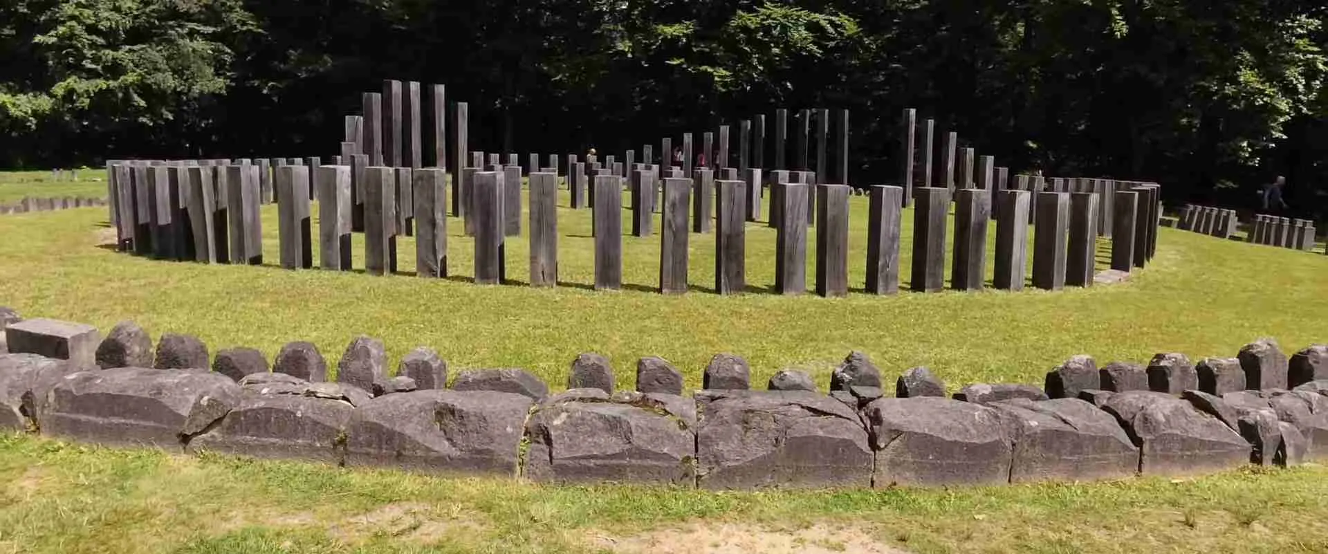
Dacian Fortresses Orastie Mountains: UNESCO Pre-Roman Heritage Guide
The Dacian Fortresses of the Orăștie Mountains represent one of Europe’s most significant pre-Roman archaeological complexes, preserving the military and religious architecture of an ancient civilization that fiercely resisted Roman conquest. These six strategically positioned strongholds in Romania’s Carpathian highlands showcase the sophisticated defensive engineering and cultural achievements of the Dacian Kingdom during its final century of independence, offering modern visitors a compelling window into Iron Age European civilization at its most innovative.
Key Takeaways: Dacian Fortresses Heritage
- Six UNESCO-Protected Fortresses: Sarmizegetusa Regia, Costești-Cetățuie, Costești-Blidaru, Piatra Roșie, Bănița, and Căpâlna form a defensive network inscribed as a UNESCO World Heritage Site in 1999, recognized under criteria ii, iii, and iv for their exceptional testimony to Dacian civilization and unique architectural fusion of classical and Iron Age European traditions.
- Murus Dacicus Construction: The fortresses demonstrate the distinctive Dacian building technique combining massive stone blocks with timber framework and rubble fill, creating walls capable of absorbing siege impact while maintaining structural integrity—an engineering innovation that distinguished Dacian military architecture from contemporary Greek and Roman fortifications.
- Capital of the Dacian Kingdom: Sarmizegetusa Regia functioned as the political, military, and religious capital of King Decebalus’s kingdom, containing not only defensive structures but also sacred precincts with circular and rectangular sanctuaries, residential quarters for nobility, and sophisticated water management systems that supported a permanent population.
- Strategic Mountain Defense System: The fortresses occupy commanding positions throughout the Orăștie Mountains, creating interlocking fields of observation and defense that protected critical approaches to the capital while controlling vital communication routes and natural resources in the southern Carpathians.
- Roman-Dacian Wars Legacy: These strongholds played central roles in the military campaigns of 101-102 CE and 105-106 CE when Emperor Trajan’s legions conquered Dacia, events commemorated in the detailed reliefs of Trajan’s Column in Rome—making the fortresses among the few Iron Age sites with both archaeological remains and contemporary visual documentation.
- Exceptional Preservation: The fortresses retain extensive above-ground remains including circuit walls, towers, gates, sanctuaries, residential foundations, and road systems, allowing visitors to comprehend the scale and sophistication of Dacian urban planning and defensive architecture without requiring extensive archaeological interpretation.
People Also Ask About Dacian Fortresses Orastie Mountains
What makes the Dacian Fortresses archaeologically significant?
The Dacian Fortresses represent the most complete surviving example of late Iron Age military and religious architecture in southeastern Europe, combining defensive engineering with sacred spaces in ways documented nowhere else in the pre-Roman world. The sites demonstrate an unusual fusion of military and religious architectural techniques drawing from both classical Mediterranean traditions and late European Iron Age practices, creating a distinctive Dacian cultural expression that disappeared following Roman conquest. The fortresses preserve in stone and timber the political and spiritual organization of a sophisticated kingdom that controlled vast territories in the Carpathian region during the first centuries BCE and CE.
Beyond their architectural importance, the fortresses provide crucial evidence for understanding the cultural and technological development of Thracian peoples who dominated southeastern Europe before Roman expansion. The extensive remains allow archaeologists to trace the evolution from earlier earthwork and palisade fortifications to sophisticated stone constructions incorporating Hellenistic design principles, documenting the process by which peripheral European societies absorbed and adapted Mediterranean architectural concepts. The presence of both military and sacred structures within single fortress complexes reveals the integrated nature of Dacian political and religious authority, offering insights into Iron Age European state formation that complement written sources from Greek and Roman historians.
Who were the Dacians and where did they live?
The Dacians were a Thracian people who inhabited the region between the Carpathian Mountains and the Danube River in what is now Romania, Moldova, and parts of Hungary, Serbia, Bulgaria, and Ukraine. First referenced by Herodotus in the 7th century BCE under the name Getae, the Dacians developed a distinctive Iron Age culture characterized by advanced metallurgy, agriculture, stock-raising, and extensive trade networks connecting them to the Greco-Roman Mediterranean world. Their society produced surplus wealth sufficient to support specialized craft production, maintain permanent fortified settlements, and engage in long-distance commerce that brought luxury goods and coinage into the Carpathian highlands.
The Dacian Kingdom reached its greatest extent and power under King Burebista in the 1st century BCE, when unified Dacian territories stretched from the Black Sea to Pannonia and from the Danube to the northern Carpathians. Following internal divisions after Burebista’s death, the kingdom was reconsolidated by King Decebalus in the late 1st century CE, who undertook massive fortification projects including the Orăștie Mountains defensive system. Dacian culture shared linguistic and cultural affinities with the Getae to their east and other Thracian groups throughout the Balkans, but developed distinctive religious practices centered on the god Zalmoxis and unique architectural traditions exemplified by the murus dacicus construction technique. The Dacians maintained their independence and cultural identity despite pressure from Celtic migrations, Scythian incursions, and Roman expansion until Emperor Trajan’s conquest in 106 CE incorporated their territories into the Roman Empire as the province of Dacia.
Why did the Romans conquer the Dacian Kingdom?
Rome’s conquest of Dacia was motivated by a combination of strategic security concerns, economic interests in the region’s mineral wealth, and imperial prestige objectives. The fortresses played an important role during the Roman-Dacian wars that culminated in two major military campaigns. The Dacian Kingdom under Decebalus had emerged as a significant military power capable of threatening Roman interests along the Danube frontier, having defeated Roman forces in earlier encounters during the 80s CE. Decebalus’s consolidation of power, extensive fortification program, and potential alliances with Rome’s enemies made the kingdom a strategic threat that Emperor Trajan determined required elimination through direct conquest rather than client-state arrangements.
Economic motivations were equally significant, as Dacia controlled rich gold and silver deposits in the Carpathian mountains that could substantially enrich the Roman treasury and fund further imperial expansion. Roman sources indicate that Trajan’s campaigns yielded enormous quantities of precious metals—the plunder from Dacia was so substantial that it funded major public works in Rome including Trajan’s Forum and Column. The conquest also provided military glory for Trajan, enhancing his reputation and legitimacy as emperor through successful foreign wars depicted in extensive propaganda including the famous spiral reliefs of Trajan’s Column. The fortresses in the Orăștie Mountains represented the heart of Dacian military power and religious authority, making their capture essential to Rome’s complete subjugation of the region. Following the kingdom’s defeat in 106 CE, the fortresses were systematically dismantled, and the Dacian population was either killed, enslaved, or integrated into the new Roman provincial system.
How did murus dacicus construction work?
Murus dacicus, the distinctive Dacian wall construction technique, consisted of a sophisticated system combining massive rectangular stone blocks forming the exterior faces with internal timber framework and rubble-earth fill creating a composite structure that provided both strength and flexibility. The characteristic method involved carefully cut and fitted limestone or andesite blocks arranged in regular horizontal courses for the visible wall faces, while timber beams placed perpendicular to the wall face and parallel tie-beams connected the inner and outer faces, creating a grid framework that held the rubble fill. This timber-stone composite construction allowed the walls to absorb impacts from siege weapons through slight deformation rather than catastrophic failure, making murus dacicus fortifications particularly resistant to battering rams and projectiles.
The construction process required substantial quarrying, timber harvesting, and specialized labor to shape stones and assemble the complex framework. Stone blocks were cut to precise dimensions, often with slightly convex faces that improved water runoff and structural interlocking. The timber framework was constructed first, establishing the wall’s width and providing scaffolding for stone placement, then progressively filled with rubble and earth as the stone faces rose. Wall thicknesses typically ranged from 3 to 5 meters, with heights reaching 6 meters or more in critical defensive positions. The technique represents a synthesis of indigenous Dacian building traditions with influences from Greek and Roman military engineering, creating fortifications that proved formidable obstacles during the Roman-Dacian wars. Archaeological evidence shows that Dacian builders could construct hundreds of meters of murus dacicus walls within fortress perimeters, demonstrating both the centralized resources available to the Dacian state and the sophisticated organizational capacity required to mobilize labor and materials on such scales.
Extended multi-day tours – 5+ days
Featured Romania Multi-Day Tour Packages

7 days
Authentic Transylvania: 7-Day Small-Group Journey
- ✓ Comprehensive Romania tour
- ✓ Expert local guides included
- ✓ All accommodation arranged
- ✓ Transportation provided
10 days
Best of Romania in 10 days
- ✓ Comprehensive Romania tour
- ✓ Expert local guides included
- ✓ All accommodation arranged
- ✓ Transportation provided
4 days
Transylvania Castles tour in 4 days from Bucharest
- ✓ Comprehensive Romania tour
- ✓ Expert local guides included
- ✓ All accommodation arranged
- ✓ Transportation provided
8 days
Transylvanian Village Life: 8-Day Carpathian Hiking & Cultural Journey
- ✓ Comprehensive Romania tour
- ✓ Expert local guides included
- ✓ All accommodation arranged
- ✓ Transportation provided
Multi-day tour packages powered by TourRadar. Prices and availability subject to change.
Introduction: Understanding Dacian Civilization Through Mountain Fortresses
The Dacian Fortresses of the Orăștie Mountains stand as Europe’s most significant pre-Roman archaeological complex, preserving in stone and earth the final century of an indigenous civilization that dominated the Carpathian region before Roman conquest reshaped southeastern Europe. Located in the southern reaches of the Carpathian Mountains in modern Romania’s Hunedoara and Alba counties, these six interconnected strongholds—Sarmizegetusa Regia, Costești-Cetățuie, Costești-Blidaru, Piatra Roșie, Bănița, and Căpâlna—formed the defensive nucleus of King Decebalus’s kingdom during the late 1st and early 2nd centuries CE. Their designation as a UNESCO World Heritage Site in 1999 recognized not only their exceptional state of preservation but also their unique testimony to a sophisticated Iron Age European society that developed distinctive architectural, religious, and military traditions while maintaining independence from the expanding Roman Empire.
The fortresses occupy strategic positions throughout the Orăștie mountain range, each site selected for its defensive advantages, visual connections to neighboring fortifications, and control over vital approach routes to the Dacian capital. This dispersed but integrated defensive system demonstrates sophisticated military planning, creating overlapping zones of observation and defense that multiplied the effectiveness of available forces while protecting the kingdom’s political and religious center. The locations range from Sarmizegetusa Regia at 1200 meters elevation, occupying a natural plateau surrounded by peaks, to Piatra Roșie at 850 meters on a prominent rocky outcrop, each fortress adapted to its specific terrain while maintaining architectural consistency through the characteristic murus dacicus construction technique.
What distinguishes the Dacian fortresses from other Iron Age European hillforts is the integration of military, administrative, and religious functions within single complexes, particularly evident at Sarmizegetusa Regia where defensive walls enclose not only residential quarters and storage facilities but also elaborate sacred precincts containing multiple circular and rectangular sanctuaries built with massive limestone columns and architectural precision rivaling contemporary Mediterranean temples. This combination reveals the centralized nature of Dacian kingship, where religious authority and military power reinforced each other through shared architectural settings. The circular sanctuaries with their precisely laid andesite blocks and timber roof structures represent a distinctive Dacian religious architectural tradition without direct parallels elsewhere in the ancient world, suggesting indigenous development rather than simple adoption of foreign models.
The historical context of the fortresses centers on the Roman-Dacian conflicts of the early 2nd century CE. Emperor Trajan launched two major military campaigns against Decebalus’s kingdom, first in 101-102 CE and decisively in 105-106 CE, motivated by Dacia’s strategic threat to Rome’s Danube frontier, the kingdom’s substantial mineral wealth, and imperial glory objectives. The Dacian fortresses, particularly the capital at Sarmizegetusa Regia, became focal points of Roman military operations. Trajan’s Column in Rome, erected to commemorate the conquest, depicts numerous scenes showing Roman forces assaulting fortified positions, besieging strongholds, and ultimately destroying Dacian defenses. These visual narratives provide contemporary documentation of the fortresses’ appearance and defensive features, making the Orăștie sites among the few Iron Age fortifications with both archaeological remains and near-contemporary artistic representation.
Archaeological investigation of the fortresses began in the 19th century but intensified dramatically during the 20th century, revealing the extent and sophistication of Dacian construction. Excavations have uncovered not only circuit walls and towers but also residential foundations, water supply systems, metallurgical workshops, storage complexes, and sacred architecture. The sites have yielded significant artifact assemblages including weapons, tools, pottery, personal ornaments, and architectural elements that document Dacian material culture and technological capabilities. Particularly notable are discoveries of Greek and Roman imported goods indicating extensive trade networks, Dacian-produced artifacts showing high craftsmanship standards, and construction details revealing advanced engineering knowledge. The fortresses’ excellent preservation results from several factors: their remote mountain locations discouraged intensive later settlement and construction, the use of durable stone and timber materials, and relatively limited disturbance from agriculture or modern development.
The UNESCO inscription of the Dacian Fortresses recognized their outstanding universal value under multiple criteria. Criterion ii acknowledges the sites’ evidence for cultural interchange between the classical Mediterranean world and late Iron Age Europe, demonstrated through architectural features, construction techniques, and artifact assemblages showing bidirectional influence. Criterion iii recognizes the fortresses as exceptional testimony to the Dacian civilization, preserving unique evidence of a cultural tradition that disappeared following Roman conquest and provincial incorporation. Criterion iv highlights the fortresses as outstanding examples of military and religious architecture representing a significant stage in human history—the transition from indigenous Iron Age societies to incorporation within the Roman Empire. Together, these criteria emphasize the fortresses’ importance for understanding European prehistory, the dynamics of Roman expansion, and the diversity of pre-Roman societies.
For contemporary visitors, the Dacian Fortresses offer an immersive encounter with pre-Roman European civilization in its natural mountain setting. The sites’ extensive above-ground remains require minimal imaginative reconstruction—visitors can walk along circuit walls, pass through gate structures, examine sanctuary foundations, and trace ancient road systems while surrounded by the dramatic Carpathian landscape that shaped Dacian settlement patterns and defensive strategies. The fortresses provide context for understanding the archaeological artifacts displayed in Romanian museums, the historical narratives recounted by Roman historians, and the visual documentation preserved on Trajan’s Column. They represent one of Europe’s most accessible and comprehensible Iron Age archaeological complexes, where the scale, organization, and sophistication of a pre-Roman kingdom become tangible through direct engagement with physical remains.
Sarmizegetusa Regia: Capital and Sacred Center of the Dacian Kingdom
Sarmizegetusa Regia functioned as the political, military, and religious capital of the Dacian Kingdom, occupying a naturally defensible mountain plateau at approximately 1200 meters elevation in the Orăștie range. The site encompasses roughly 30,000 square meters of fortified area, with defensive walls extending nearly 1000 meters in irregular polygonal circuits adapted to the terrain’s natural contours. The settlement probably dates to the mid-1st century BCE, developing from earlier Iron Age occupation into a major urban center under Kings Burebista and Decebalus when it became the kingdom’s administrative and ceremonial focus. The capital’s remote mountain location, difficult access, and natural defensive advantages reflected Dacian strategic priorities—creating a secure base for royal authority protected from surprise attack while maintaining connections to the broader kingdom through mountain roads and visual signaling systems.
The fortress’s defensive architecture demonstrates the fully developed murus dacicus technique at its most sophisticated scale. Circuit walls consisted of carefully fitted stone blocks forming exterior faces up to 6 meters high, with internal timber framework and rubble fill creating composite structures averaging 3-4 meters thick. Archaeological investigation has revealed construction phases spanning several decades, with initial defenses reinforced and extended as the settlement’s importance grew. The main entrance, positioned on the western approach, incorporated gateway structures with flanking towers providing enfilade coverage of approaching enemies. Additional smaller gates served specific functions including ceremonial access to the sacred precinct and utilitarian entries for supply transport. Towers punctuated the circuit walls at strategic intervals, providing elevated observation positions and platforms for defensive projectiles while breaking up wall segments to prevent catastrophic failure if one section was breached.
Within the fortified perimeter, Sarmizegetusa Regia contained functionally distinct zones reflecting its multiple roles. The residential quarter occupied the southern and eastern sections, with foundations indicating stone-based structures with timber superstructures arranged along terraced slopes. These dwellings housed the royal household, noble families, administrative officials, religious specialists, and artisans whose skills served the capital’s functions. Archaeological finds from residential contexts include imported Mediterranean pottery, luxury goods, metalwork, and personal ornaments indicating the wealth and cosmopolitan connections of the capital’s inhabitants. Storage structures, cisterns, and metallurgical workshops demonstrate the settlement’s economic self-sufficiency and specialized craft production.
The sacred precinct occupies the northwestern area of the fortress, containing multiple sanctuaries that represent the most architecturally sophisticated religious structures known from pre-Roman Dacia. The complex includes several large circular sanctuaries built with massive limestone and andesite blocks arranged in precise circular patterns, with diameters ranging from 12 to 30 meters. The largest circular sanctuary, approximately 30 meters in diameter, consisted of concentric rings of timber posts supporting a conical roof structure, with stone block foundations providing permanent bases. These circular structures likely served as temples dedicated to primary Dacian deities, with roofed interior spaces allowing sheltered ritual activities. The precision of construction, quality of stone cutting, and architectural scale demonstrate the religious importance of these structures and the resources the Dacian state devoted to their creation.
Alongside the circular sanctuaries stand rectangular temple structures exhibiting even more direct influence from classical Mediterranean architecture. These rectangular sanctuaries feature rows of massive limestone columns arranged on plinths, creating colonnaded structures reminiscent of Greek and Roman temple designs but adapted to Dacian religious requirements and mountain building conditions. The columns, some exceeding 2 meters in height with carved capitals showing geometric and vegetal motifs, represent sophisticated stone carving and architectural engineering. The rectangular sanctuaries’ orientation, internal arrangements, and relationship to the circular structures suggest complementary religious functions, possibly distinguishing different deities, ritual types, or participant groups within Dacian religious practice.
Water management systems at Sarmizegetusa Regia reveal advanced engineering capabilities. The site includes elaborate ceramic pipe networks bringing water from mountain springs to cisterns within the fortress, providing reliable supply independent of vulnerable external sources. Archaeological excavations have traced these pipelines through multiple sections, documenting their construction from fitted ceramic tubes with sealed joints capable of maintaining water pressure over considerable distances and elevation changes. The presence of both utilitarian water storage and what may be sacred pools or fountains within the sanctuary area indicates water’s importance in both practical settlement maintenance and religious ritual. These hydraulic systems represent some of the most sophisticated water engineering in pre-Roman temperate Europe.
Road and terrace systems structure the capital’s internal organization. Stone-paved roads connected functional zones, gates, and major structures, their engineering allowing movement of goods and people across the sloped terrain while providing drainage. Extensive terracing transformed the natural hillside into usable horizontal spaces for construction, requiring massive earth movement and retaining wall construction. The visibility of these roads and terraces in the present landscape testifies to construction quality and the scale of labor invested in creating the capital’s infrastructure. These features demonstrate urban planning sophistication comparable to contemporary Mediterranean cities, challenging assumptions about the limited capabilities of “barbarian” societies beyond Roman frontiers.
Sarmizegetusa Regia’s role extended beyond local administration to function as symbolic center of Dacian identity and power. As the location where kings performed religious ceremonies, held councils, received envoys, and directed military operations, the capital embodied Dacian sovereignty in physical form. Its mountain location and defensive strength reinforced messages about Dacian military capabilities and determination to resist external threats. The sacred precinct’s architectural elaboration conveyed religious authority supporting political power, while the residential quarter’s luxury goods and specialized workshops demonstrated the kingdom’s wealth and cultural sophistication. When Roman forces finally captured and destroyed Sarmizegetusa Regia in 106 CE, they not only eliminated a military strongpoint but dismantled the physical embodiment of Dacian kingship.
Post-conquest, the Romans systematically demolished much of the capital’s architecture, dismantling defensive walls, destroying religious structures, and dispersing the population. However, the site’s remote location and subsequent limited reoccupation preserved extensive remains including foundation courses, lower wall sections, column drums, terrace systems, and ceramic pipe fragments. Modern archaeological investigation, beginning in the early 20th century and continuing through recent decades, has uncovered the capital’s layout and functional organization while recovering substantial artifact assemblages. Conservation efforts have stabilized vulnerable structures and made portions of the site accessible to visitors, allowing direct engagement with Dacia’s most important archaeological location. The capital remains the focal point for understanding Dacian civilization, its architectural ambitions, religious practices, and political organization during the kingdom’s final independent decades.
Costești-Cetățuie: Northern Defensive Anchor Protecting Capital Approaches
Costești-Cetățuie occupies a commanding hilltop position approximately 6 kilometers northwest of Sarmizegetusa Regia, controlling the primary approach route from the lower Mureș River valley to the Dacian capital. The fortress’s strategic location allowed observation of valleys extending northward toward Deva and westward toward the Mureș, providing early warning of approaching forces while its elevation and defensive works created a formidable obstacle blocking direct access to Sarmizegetusa. The site demonstrates the Dacian defensive strategy of creating layered defenses anchored by major fortresses that multiplied the difficulty of reaching the kingdom’s heartland. Archaeological evidence indicates the fortress was continuously occupied and militarily active during the late 1st and early 2nd centuries CE, playing a significant role in the Roman-Dacian conflicts.
The fortress’s defensive architecture evolved through multiple construction phases, documenting the progression from earthwork and palisade fortifications to sophisticated stone constructions incorporating Hellenistic design principles. Earlier phases, dated to the 1st century BCE, consisted of earth ramparts reinforced with timber palisades and protected by external ditches—typical Iron Age hillfort defenses relying on earthwork mass and timber obstacles. Later construction phases, particularly during Decebalus’s reign, replaced or reinforced these earlier defenses with murus dacicus stone walls creating more permanent and siege-resistant structures. This architectural evolution visible at Costești-Cetățuie exemplifies the broader transformation of Dacian military architecture as the kingdom consolidated under centralized royal authority and adapted to Roman military threats.
The fortress’s circuit walls follow the hilltop’s irregular perimeter, creating a fortified enclosure of approximately 5 hectares. The walls combine natural terrain features with constructed defenses, positioning stone ramparts along vulnerable approaches while incorporating steep rocky slopes as natural barriers where topography provided adequate protection. Archaeological investigation has revealed substantial wall sections with heights up to 4 meters, built using the characteristic Dacian technique of stone block faces with timber-reinforced rubble cores. The walls’ varying thickness—ranging from 2 to 4 meters depending on position and exposure—reflects engineering responses to different threat levels, with thicker sections protecting gates and vulnerable approaches.
The main gate complex at Costești-Cetățuie demonstrates sophisticated defensive design. Located on the western approach where terrain required entry, the gate incorporated flanking towers and an internal courtyard creating a killing ground where attackers penetrating the outer gateway faced concentrated defensive fire from elevated positions before reaching the inner fortress. This design, showing Hellenistic influence, transformed the vulnerable entry point into a defensive advantage. Archaeological evidence suggests the gate structure included timber upper stories providing covered positions for defenders, while stone foundations preserved the gateway’s passage dimensions and internal arrangements. The gate’s architecture reveals Dacian adaptation of Mediterranean defensive concepts to local construction techniques and materials.
Within the fortified perimeter, Costești-Cetățuie contained military barracks, storage facilities, workshop areas, and residential structures supporting its garrison and administrative functions. Foundation remains indicate rectangular stone-based buildings with timber superstructures, arranged to maximize use of the hilltop’s limited flat space. The fortress’s layout prioritizes military functionality over religious or ceremonial elaboration, distinguishing it from Sarmizegetusa Regia’s multipurpose organization. Artifact assemblages recovered from the site include military equipment, iron tools, pottery for storage and cooking, and limited luxury goods, confirming the fortress’s primarily military character. The presence of metallurgical workshops indicates on-site weapon and tool production or repair, supporting the garrison’s operational independence during periods of conflict.
Water supply arrangements at Costești-Cetățuie addressed the hilltop location’s primary vulnerability. Archaeological evidence indicates cisterns for rainwater collection and storage, providing reserves during sieges when access to lower valley springs became impossible. The presence of these water management systems demonstrates Dacian awareness of siege warfare realities and efforts to enhance fortresses’ ability to withstand prolonged isolation. The cisterns’ capacity, though limited compared to Sarmizegetusa Regia’s spring-fed systems, allowed the garrison to maintain resistance for extended periods.
Costești-Cetățuie’s military history came to a violent end during Trajan’s second Dacian campaign in 105-106 CE. Archaeological evidence includes destruction layers with burned materials, collapsed wall sections, and artifact scatters indicating military assault and occupation. Roman siege techniques, including assault ramps visible in relief sculptures on Trajan’s Column, probably featured in the fortress’s capture. Following conquest, the Romans systematically dismantled the defenses to prevent future military use, though the site’s ruins remained substantial enough to allow modern archaeological reconstruction of its plan and functions.
Today, Costești-Cetățuie preserves extensive architectural remains that allow visitors to comprehend Dacian defensive engineering and military strategy. Circuit walls remain visible along much of their perimeter, gate structures show sophisticated design concepts, and foundation traces reveal internal organization. The fortress’s hilltop position provides the same commanding views Dacian defenders observed, allowing modern visitors to understand the strategic reasoning behind site selection. The ruins complement those at Sarmizegetusa Regia, offering insights into Dacian military architecture distinct from the capital’s religious and administrative focus. Costești-Cetățuie exemplifies the fortress type that formed Dacia’s defensive backbone—militarily focused strongpoints controlling strategic positions throughout the kingdom.
Costești-Blidaru: Lower Fortress Controlling Valley Access Routes
Costești-Blidaru occupies a lower elevation position approximately 1 kilometer west of Costești-Cetățuie, situated at roughly 600 meters altitude where the Grădiștei River emerges from the mountains into the broader Mureș valley. This location controlled valley-level approach routes and river crossing points, complementing the hilltop fortress’s strategic observation position. The two fortresses at Costești—Cetățuie on the heights and Blidaru in the valley—functioned as an integrated defensive system, with the upper fortress providing early warning and strategic overview while the lower fortress blocked actual movement along valleys and roads. This pairing demonstrates Dacian strategic sophistication, creating layered defenses that required attackers to capture multiple positions before penetrating to the capital region.
Costești-Blidaru’s defensive architecture adapted to its valley-floor setting, where topographic advantages were less pronounced than on hilltop sites. The fortress consisted of an earth and stone rampart roughly 2 meters high enclosing an irregular rectangular area of approximately 3 hectares. Archaeological investigation reveals murus dacicus construction in critical wall sections, particularly protecting gates and vulnerable approaches, while other portions relied on earth ramparts with timber palisades—a cost-effective approach allocating stone construction resources where most needed. This variation in defensive construction demonstrates practical engineering decisions balancing defensive requirements against available resources and labor.
The fortress’s internal organization reflects its role as a military post and transit point rather than permanent settlement. Foundation remains indicate barracks-style structures arranged in rows, storage buildings for supplies, and workshop areas for equipment maintenance. The relative absence of luxury goods and limited religious architecture distinguish Blidaru from both Sarmizegetusa Regia and the more elaborate hilltop fortresses, suggesting a garrison population focused on military duties. Artifact assemblages include military equipment, utilitarian pottery, iron tools, and evidence of metalworking activities. The fortress likely housed soldiers controlling the valley route while supporting operations at the adjacent hilltop fortress.
Water supply at Costești-Blidaru benefited from the site’s valley location, with the Grădiștei River providing abundant water without the cistern requirements of hilltop fortresses. Archaeological evidence indicates wells within the fortified perimeter, accessing groundwater at shallow depths. This reliable water supply enhanced the fortress’s ability to support larger garrisons and withstand sieges, compensating somewhat for the defensive disadvantages of valley-floor positioning. The relationship between water access and site selection reveals Dacian military planners’ consideration of multiple factors in defensive system design.
The relationship between Costești-Blidaru and Costești-Cetățuie exemplifies Dacian defensive strategy integrating fortresses at different elevations into coordinated systems. Visual signals, likely fire or smoke during daytime and torches at night, allowed rapid communication between the paired fortresses. An attacking force advancing along valley routes would face obstruction at Blidaru while being observed from Cetățuie above; forces attempting to bypass Blidaru by ascending toward Cetățuie would expose themselves to observation and potential counterattack from the valley fortress. This complementary positioning multiplied defensive effectiveness beyond what either fortress could achieve independently.
Archaeological investigation at Costești-Blidaru has been less extensive than at larger fortresses, but excavations have clarified the site’s layout, construction techniques, and functional character. The fortress represents a site type essential to understanding Dacian defensive organization—the secondary military post supporting more strategically critical positions. While less architecturally elaborate than Sarmizegetusa Regia or ceremonially significant than major hilltop fortresses, Blidaru exemplifies the practical military installations that made Dacian resistance to Roman conquest as effective as it proved. The Romans’ need to capture such secondary positions as part of their systematic reduction of Dacian defenses demonstrates these fortresses’ military importance despite their relative archaeological simplicity.
Today, Costești-Blidaru remains less visited than adjacent Costești-Cetățuie, but the site preserves foundation remains, defensive earthworks, and sufficient structural evidence to convey its military character. The valley location allows visitors to appreciate terrain factors in Dacian site selection and understand the integrated nature of multi-fortress defensive systems. The ruins complement the more dramatic hilltop remains, offering a complete picture of Dacian military engineering across different topographic settings. For visitors interested in ancient military history, the Costești fortress pair provides an unusually complete example of coordinated defensive positioning.
Piatra Roșie: Western Outpost Fortress and Early Warning Station
Piatra Roșie, meaning “Red Rock” in Romanian, occupies a prominent rocky outcrop at approximately 850 meters elevation near the village of Luncani in Boșorod commune, positioned roughly 25 kilometers west of Sarmizegetusa Regia. The fortress’s strategic importance derived from its position controlling western approaches to the Dacian heartland and providing observation over valleys connecting the Orăștie mountain region to territories beyond the Carpathian arc. The distinctive reddish-colored stone of the outcrop, giving the fortress its name, creates a visually striking landmark visible from considerable distances—a characteristic that enhanced its value as a signaling station within the broader defensive network. Historical sources suggest Piatra Roșie could be reached by a two-day march from Costești, establishing the fortress’s role as an outlying post projecting Dacian defensive presence westward.
The fortress was constructed in two distinct phases, with archaeological evidence documenting evolving defensive concepts and expanding fortified area. The first phase created a long rectangular main citadel, measuring approximately 102 meters in length, positioned along the outcrop’s highest elevation. Watch towers anchored each end of this central fortification, with two additional outlying towers positioned at lower elevations. This initial configuration focused defensive resources on the elevated central area while extending observation capabilities through forward towers. The design demonstrates military architectural principles emphasizing concentrated strength in the core citadel while projecting surveillance capabilities beyond the main defensive perimeter.
The second construction phase expanded the fortified area substantially, enclosing the larger space between the outlying watch towers with circuit walls creating a more extensive defended perimeter. This expansion required additional construction resources and labor, suggesting increased military importance or garrison requirements. Archaeological analysis indicates the expansion involved earth moving to flatten portions of the hilltop, creating more usable internal space for structures and activities. This landscape modification, substantial in scale, demonstrates the engineering capabilities and labor mobilization capacity available to Dacian military authorities. The resulting fortress enclosed multiple hectares, providing space for garrison quarters, storage facilities, and operational areas.
Defensive architecture at Piatra Roșie incorporated the characteristic murus dacicus technique, with stone block walls reinforced by timber framework visible in foundation remains. The rocky outcrop itself provided natural defensive barriers along portions of the perimeter, with constructed walls protecting vulnerable approaches. The combination of natural rock faces and built fortifications created formidable obstacles to assault while economizing on construction materials by utilizing topographic advantages. Wall sections surviving to modern times demonstrate construction quality, with carefully fitted blocks and preserved sections showing original height and thickness dimensions.
The fortress’s watch towers served critical observation functions within the defensive network. Their elevated positions and western orientation allowed observation of valleys and approaches extending well beyond the immediate fortress vicinity. Visual communication through signal fires or smoke could relay warnings to other fortresses including Costești and Sarmizegetusa Regia, providing early alert of approaching threats. This signaling capacity transformed isolated fortresses into an integrated defensive system where information traveled far faster than attacking forces, allowing coordinated responses and force concentration. Archaeological remains of the towers, including foundation platforms and access stairways, reveal their construction scale and strategic placement.
Artifact assemblages recovered from Piatra Roșie include military equipment, pottery, iron tools, and metalwork indicating garrison occupation and functional military use. A particularly notable find, subject to ongoing scholarly debate, is a circular metal artifact that may represent either a shield umbo or an architectural gate decoration. The object’s form, decorative elements, and context provide insights into Dacian metalworking capabilities and artistic traditions. Its uncertain function exemplifies the interpretive challenges archaeologists face with isolated artifacts from societies that left limited written records. Whether military equipment or architectural ornament, the object demonstrates sophisticated metallurgical techniques and decorative sensibilities.
Piatra Roșie’s role in the Roman-Dacian wars remains partially documented in Roman sources and Trajan’s Column reliefs. The fortress’s capture by Roman forces required military effort commensurate with its defensive strength, though the site’s distance from the primary conflict zones around Sarmizegetusa Regia may have allowed its continued Dacian control through portions of Trajan’s campaigns. Following the kingdom’s final defeat, the fortress was dismantled like other Dacian strongholds, though its remote location preserved substantial ruins from later disturbance or building material robbery.
Modern archaeological investigation at Piatra Roșie has clarified the fortress’s construction phases, defensive features, and functional organization. The site’s preservation status allows visitors to observe circuit walls, tower foundations, internal terraces, and gate structures while appreciating the commanding views and defensive advantages that motivated its construction. The rocky outcrop’s dramatic topography and the fortress ruins’ integration with natural stone create a particularly visually striking example of Dacian military architecture adapted to specific landscape features. Among the six UNESCO-designated fortresses, Piatra Roșie offers one of the most accessible and comprehensible examples of outlying defensive posts within the integrated Dacian system.
Bănița Fortress: Southern Defensive Position Guarding Capital Access
Bănița fortress occupies a strategic hilltop position south of Sarmizegetusa Regia, controlling approaches from the southern Carpathian valleys and Jiu River watershed toward the Dacian capital. The fortress’s location reflects defensive planning extending protection across multiple approach directions, ensuring potential attackers from any cardinal direction faced fortified obstacles before reaching the kingdom’s core. Positioned at approximately 900 meters elevation, Bănița commanded views over valleys and ridges extending southward, providing observation and defensive capabilities complementing the western positions at Piatra Roșie and northern defenses at Costești. This geographic distribution of fortresses created concentric protective zones around Sarmizegetusa Regia, multiplying defensive depth and complexity.
The fortress architecture at Bănița demonstrates typical Dacian hilltop fortification design adapted to specific topographic conditions. Circuit walls of murus dacicus construction follow the hilltop’s natural contours, enclosing a fortified area where foundation remains indicate military and residential structures. The fortress’s scale, while smaller than Sarmizegetusa Regia or major defensive positions like Costești-Cetățuie, was sufficient for a garrison capable of controlling the southern approaches and providing observation services. Archaeological investigation has revealed wall sections, gate structures, and internal organization typical of Dacian military posts, with artifact assemblages confirming occupation during the late 1st and early 2nd centuries CE.
Water supply at Bănița relied on cisterns collecting and storing rainwater, addressing the hilltop location’s lack of natural springs. Archaeological remains of these water storage facilities indicate engineering attention to siege sustainability, though the limited capacity compared to capital sites suggests the fortress functioned primarily as an observation and control point rather than a position intended to withstand prolonged independent sieges. The water systems exemplify practical engineering solutions Dacian military architects deployed across fortified sites with varying natural resource access.
The fortress’s strategic value derived from its integration into the broader defensive network. Visual communication with other fortresses, particularly Sarmizegetusa Regia to the north, allowed rapid information transmission about southern approaches. The fortress positioned Dacian forces to observe potential threats, delay attacking forces, and coordinate with other defensive positions in responding to military challenges. This networked defensive concept, where individual fortresses derived strength from their integration within broader systems, represented sophisticated strategic thinking beyond simple isolated strongpoint defense.
Archaeological evidence from Bănița includes the full range of materials typical of Dacian military sites: pottery for storage and consumption, iron tools and weapons, structural remains indicating building types and layouts, and limited decorative or luxury items. The artifact profile confirms the fortress’s primarily military function, distinguishing it from Sarmizegetusa Regia’s multifunctional character. Metallurgical evidence indicates weapon maintenance and limited production capabilities, allowing the garrison operational independence in equipment upkeep. These findings document the practical military activities sustaining garrison life and defensive readiness.
Bănița’s role in the Roman-Dacian conflicts followed the general pattern of Dacian fortress capture during Trajan’s campaigns. Roman forces systematically reduced the fortified positions protecting approaches to Sarmizegetusa Regia, eliminating the defensive network that made direct assault on the capital so challenging. Archaeological destruction layers at Bănița indicate military capture and subsequent dismantling, consistent with Roman policy of eliminating Dacian fortification capability. The fortress’s fall contributed to the isolation of Sarmizegetusa Regia that preceded the capital’s ultimate capture and destruction.
Contemporary archaeological remains at Bănița preserve circuit walls, foundation traces, and sufficient structural evidence for understanding the fortress’s layout and defensive features. The site’s hilltop position maintains the commanding views that motivated its strategic placement, allowing visitors to appreciate terrain factors in Dacian military planning. While less extensively excavated or visited than major fortresses, Bănița represents an essential component of the integrated defensive system—the secondary position providing depth and coverage across multiple approaches. The fortress exemplifies Dacian strategic planning that created layered, distributed defenses rather than concentrating all resources in single positions.
Căpâlna Fortress: Eastern Defense Position in Multi-County System
Căpâlna fortress occupies a strategic position east of Sarmizegetusa Regia in what is now Alba County—the only one of the six UNESCO-designated fortresses located outside Hunedoara County. This geographic position reflects the fortress’s role protecting eastern approaches to the Dacian capital while controlling routes connecting the Orăștie mountain region to territories eastward toward the Olt River valley and beyond. The fortress’s elevation and terrain positioning provided observation over valleys and mountain passes, extending Dacian defensive coverage across a broader geographic area than fortresses concentrated around the immediate capital vicinity could achieve. Căpâlna’s integration into the defensive network demonstrates the system’s regional rather than purely local scale, encompassing multiple mountain ranges and valleys across what now constitutes several administrative counties.
The fortress architecture at Căpâlna followed standard Dacian hilltop fortification principles, with murus dacicus circuit walls enclosing a defended area atop naturally advantageous terrain. Archaeological investigation has revealed defensive features typical of Dacian military construction: stone block walls with timber reinforcement, gate structures with defensive capabilities, internal terracing to create usable space, and foundation remains indicating structures for garrison housing and military functions. The fortress’s construction quality and defensive elaboration indicate its importance within the broader system, meriting substantial resource investment despite its distance from the capital center.
The fortress’s strategic value derived from several factors beyond immediate capital defense. Eastern approaches from territories beyond the Carpathian arc required monitoring and control to prevent surprise attacks from that direction. The fortress potentially controlled local resources including timber, minerals, or agricultural production in surrounding valleys. The site may have served administrative functions for eastern territories, housing officials managing royal interests and collecting tribute or taxes. These multiple functions—military, economic, administrative—illustrate how individual fortresses integrated into broader state structures rather than serving exclusively defensive purposes.
Archaeological evidence from Căpâlna includes artifact assemblages documenting garrison occupation during the late Dacian kingdom period. Pottery, iron implements, building materials, and limited luxury goods indicate residential occupation alongside military functions. The presence of workshop areas suggests on-site production or repair activities, contributing to the fortress’s operational independence. These material remains document the daily activities sustaining fortress life beyond dramatic military events, revealing the mundane realities of garrison existence and settlement maintenance.
Water supply arrangements at Căpâlna addressed the hilltop location’s resource constraints through cistern systems collecting rainfall and storing water for dry periods or sieges. Archaeological remains of these water management features demonstrate engineering solutions Dacian builders deployed across similar topographic settings. The water systems’ capacity, while limited compared to spring-fed sites, provided sufficient reserves for normal garrison needs and short-term siege resistance. This engineering attention to resource sustainability reveals Dacian military planners’ awareness of fortification requirements beyond purely defensive architecture.
Căpâlna’s fate during the Roman-Dacian wars followed the general pattern of fortress capture and dismantling. As Roman forces systematically eliminated Dacian defensive positions during Trajan’s campaigns, Căpâlna would have faced assault as part of the broader reduction of fortified sites protecting access to Sarmizegetusa Regia. Archaeological evidence indicates destruction consistent with military capture, including wall demolition and limited later occupation. The Romans’ systematic dismantling of Dacian fortifications aimed to prevent future military use and eliminate the physical infrastructure of independent Dacian state power.
Contemporary remains at Căpâlna preserve circuit wall sections, gate features, internal organization traces, and sufficient structural evidence for archaeological interpretation. The site’s position in Alba County rather than the concentration area around Sarmizegetusa Regia in Hunedoara County highlights the defensive network’s geographic extent. For visitors exploring the complete fortress system, Căpâlna demonstrates the distributed nature of Dacian defense and the multi-county scale of their strategic planning. The fortress represents eastern extension of the integrated defensive concept centered on the Orăștie mountain region but extending protection across broader Dacian territories.
Murus Dacicus Construction Technique: Engineering Analysis and Mediterranean Influences
The murus dacicus construction technique represents one of the most distinctive architectural innovations of pre-Roman Dacia, creating defensive walls that combined stone masonry with timber framework in a composite system providing both strength and flexibility. This building method distinguishes Dacian fortifications from contemporary Greek and Roman stone walls as well as from Celtic and Germanic timber-and-earth fortifications, representing a unique synthesis adapted to local materials, construction capabilities, and defensive requirements. The technique’s name, assigned by modern archaeologists, derives from the Latin term for “Dacian wall,” acknowledging its association with fortifications throughout the Dacian kingdom during the 1st centuries BCE and CE.
The construction process began with quarrying limestone or andesite stone blocks, which were cut and shaped to form regular rectangular blocks suitable for wall construction. These blocks, typically measuring 30-50 centimeters in length and 20-30 centimeters in height, were cut with smooth faces and relatively precise dimensions allowing tight fitting. The stone faces were sometimes slightly convex, improving water runoff and creating interlocking surfaces that enhanced structural stability. Quarrying locations often existed near fortress sites, though some stone was transported considerable distances when local sources proved inadequate or unsuitable. The scale of quarrying required to supply major fortification projects like Sarmizegetusa Regia’s circuit walls indicates substantial labor organization and resource mobilization capabilities within the Dacian state.
The timber framework, integral to murus dacicus construction, consisted of horizontal and perpendicular beams creating a three-dimensional grid within the wall’s interior. Timber pieces were cut to lengths spanning the wall’s thickness, typically 3-5 meters depending on the wall’s position and defensive requirements. These transverse timbers connected the exterior and interior stone faces, preventing separation under impact and distributing loads throughout the wall’s depth. Parallel timbers placed along the wall’s length provided additional structural integration. The timber framework was constructed first, establishing the wall’s dimensions and providing working scaffolding for stone placement. This sequence—timber grid followed by progressive stone and rubble fill—allowed relatively rapid wall construction while ensuring structural integrity.
The space between exterior and interior stone faces was filled with rubble—broken stone fragments, earth, and gravel—compacted as construction progressed. This fill material, contained by the timber framework and stone faces, created a mass that absorbed impact energy from siege weapons. Unlike solid stone walls that could shatter catastrophically under concentrated impact, the murus dacicus composite structure allowed slight deformation and energy absorption through the rubble fill’s displacement, distributing forces and preventing complete failure. This engineering characteristic made murus dacicus walls particularly resistant to battering rams, the primary siege weapon of the period capable of breaching fortifications through repeated impact.
Wall dimensions varied according to strategic importance and defensive exposure. Circuit walls at major fortresses like Sarmizegetusa Regia reached 3-4 meters in thickness and 5-6 meters in height, creating formidable barriers requiring substantial siege efforts to breach. Secondary walls protecting less critical approaches or used in interior divisions were constructed with reduced dimensions, economizing on materials and labor. Gates and towers required specially reinforced construction, with thicker walls and additional timber framing supporting concentrated defensive structures. This variation in wall construction according to function demonstrates engineering sophistication beyond simple application of standard techniques.
The murus dacicus technique shows clear influences from Hellenistic military architecture, particularly in the use of stone block construction and concepts of wall thickness proportional to height. Dacian builders likely observed or learned about Greek and Roman fortification techniques through trade contacts, diplomatic exchanges, military conflicts, or craftsmen traveling between regions. However, Dacian adaptation of these concepts incorporated indigenous timber construction traditions, creating a hybrid technique suited to local materials, climate, and defensive requirements. The timber framework, particularly characteristic of murus dacicus construction, has no direct parallel in Mediterranean stone fortifications, suggesting Dacian innovation beyond simple copying of foreign models.
Archaeological investigation has revealed murus dacicus construction details through excavation of collapsed or deliberately demolished wall sections. These investigations show timber beam placement, rubble composition, stone cutting techniques, and construction sequences. In some cases, organic materials preserved in collapsed sections have allowed radiocarbon dating of construction phases. The timber components, while degraded or destroyed in most contexts, left voids or impressions in the rubble matrix revealing their original positions and dimensions. These archaeological traces, combined with standing wall sections preserving original construction, allow detailed reconstruction of the building technique.
The durability of murus dacicus construction is evident in the extensive ruins surviving at fortress sites despite two millennia of weathering, deliberate Roman demolition, and limited later building material robbery. Stone faces retain their positions in many wall sections, with multiple courses visible showing original heights. The quality of stone cutting and fitting has prevented complete collapse even where timber framework decayed or was destroyed. This preservation provides modern visitors with direct evidence of Dacian construction capabilities and engineering sophistication, making the fortresses among Europe’s most accessible examples of pre-Roman military architecture.
The murus dacicus technique influenced regional architecture beyond purely military contexts, with elements appearing in residential and religious structures at Dacian sites. The combination of stone and timber construction, while most elaborated in defensive walls, represented a broader Dacian building tradition adapted to different architectural requirements. This diffusion of techniques from military to civilian contexts demonstrates the integrated nature of Dacian material culture and the skilled craftsmen’s movement between different construction projects throughout the kingdom.
Religious Architecture and Sacred Spaces Within Dacian Fortresses
The integration of sacred precincts within Dacian fortresses, particularly elaborate at Sarmizegetusa Regia, represents a distinctive characteristic of Dacian civilization differentiating their fortifications from purely military installations. This combination of defensive and religious functions reflects the integrated nature of Dacian kingship, where political authority derived legitimacy from religious sanction and control of sacred spaces and rituals. The architectural elaboration of sanctuary structures within fortress walls demonstrates the resources Dacian rulers devoted to religious construction and the importance of ritual activities in maintaining social cohesion and political power. Understanding these sacred spaces provides crucial insights into Dacian religious beliefs, social organization, and cultural identity beyond the military history that dominates historical narratives.
The circular sanctuaries at Sarmizegetusa Regia represent the most architecturally sophisticated religious structures in pre-Roman temperate Europe. These structures, ranging from approximately 12 to 30 meters in diameter, consisted of concentric circles of timber posts set on massive stone foundations, creating circular colonnades supporting conical roof structures. The largest sanctuary’s outer ring contained posts spaced at regular intervals, with stone block bases providing permanent foundations preventing rot and settlement. Interior rings of posts, progressively smaller in diameter, supported roof elements creating covered interior spaces suitable for ritual activities sheltered from weather. The precision of circular layout, regularity of post spacing, and scale of construction demonstrate advanced architectural planning and engineering capabilities.
Archaeological investigation of the circular sanctuaries has revealed construction techniques and architectural details. Stone foundation blocks, many still in situ, show socket holes where timber posts were seated, with evidence of the posts’ dimensions preserved in the stone cutting. The blocks’ circular arrangement, measured and documented through archaeological survey, allows reconstruction of the structures’ original plans and dimensions. Analysis of stone cutting techniques, tool marks, and architectural proportions indicates knowledge of geometric principles and careful planning preceding construction. The sanctuaries’ architectural sophistication rivals contemporary Mediterranean temples, challenging assumptions about limited capabilities of societies beyond classical civilization’s borders.
The rectangular sanctuaries at Sarmizegetusa Regia show even more direct Mediterranean architectural influence, featuring colonnaded structures with limestone columns on plinths arranged in rectangular plans. These columns, some exceeding 2 meters in height, were carved from single stone blocks with capitals showing decorative elements including geometric patterns and stylized vegetal motifs. The columns supported timber architraves and roof structures creating covered interior spaces similar in concept to Greek and Roman temple designs. The rectangular sanctuaries’ presence alongside circular structures suggests different ritual functions or dedications to different deities, with architectural form reflecting religious distinctions within Dacian belief systems.
The sacred precinct’s organization at Sarmizegetusa Regia shows careful planning integrating multiple sanctuary types, ceremonial spaces, and probable residential areas for religious specialists. Stone-paved roads connected different sanctuary structures, creating processional routes for religious ceremonies. The precinct’s elevated position within the fortress and separation from residential quarters emphasized the sacred area’s special status and restricted access. This spatial organization reflects concepts about sacred space common across ancient cultures, where physical separation and elevated position conveyed spiritual importance and reinforced religious authority’s social role.
The religious significance of these sanctuaries relates to known elements of Dacian religion from limited historical sources. Greek and Roman writers mention Dacian worship of gods including Zalmoxis, described as a deity concerned with immortality, and Gebeleizis, associated with thunder. The circular sanctuaries’ architectural form and astronomical alignments suggested by some researchers indicate possible connections to celestial observation and ritual calendars linked to agricultural cycles. The combination of circular and rectangular structures might reflect distinctions between indigenous Dacian deities and syncretic worship incorporating Greek or Roman religious concepts. However, the limited written evidence prevents definitive interpretation of specific sanctuaries’ dedications or ritual uses.
Artifacts recovered from sanctuary contexts provide some evidence for religious activities. Finds include pottery vessels possibly used in libations or offerings, iron tools that might have been votive deposits, and occasional decorative items. The general scarcity of elaborate votive offerings compared to Mediterranean sanctuaries reflects either different Dacian ritual practices, post-abandonment looting, or Roman plundering following conquest. The Romans systematically destroyed Dacian religious structures, both eliminating competing religious authorities and extracting valuable materials from sanctuary buildings. This destruction unfortunately removed much of the archaeological evidence that might clarify Dacian religious practices and beliefs.
The presence of sacred precincts within fortresses served multiple functions beyond purely religious purposes. Controlling major sanctuaries reinforced royal authority, as kings who patronized temple construction and presided over important rituals demonstrated their religious legitimacy and divine sanction. Temples served as treasury locations where accumulated wealth in precious objects could be guarded within fortified precincts. Religious festivals and rituals brought populations together, reinforcing social bonds and shared identity while allowing rulers to display their power and resources through elaborate ceremonies. These interconnected political, economic, and religious functions made sanctuary control central to state power in pre-Roman societies.
The destruction of Dacian sacred architecture following Roman conquest aimed to eliminate indigenous religious practices and institutions that supported resistance to Roman authority. The systematic dismantling of temples, particularly at Sarmizegetusa Regia, symbolically demonstrated Roman victory over not just Dacian military power but also their gods and religious traditions. This religious conquest component of Roman expansion, often overlooked in military-focused narratives, proved essential to long-term provincial control and cultural transformation. The ruined sanctuaries at modern fortress sites testify to both the architectural achievements of Dacian civilization and the violent cultural disruption of Roman conquest.
Archaeological Research History and Interpretive Developments
Archaeological investigation of the Dacian fortresses began during the 19th century when early antiquarians and scholars documented visible ruins and conducted limited excavations. These pioneering efforts, though lacking modern scientific methods, established the sites’ importance and provided initial documentation of architectural remains. Romanian scholars took particular interest in Dacian archaeology as evidence of pre-Roman indigenous civilization in territories that became modern Romania, making the fortresses focal points for developing national historical narratives. This early research phase established basic knowledge about the fortresses’ locations, visible features, and relationship to historical accounts of Roman-Dacian conflicts.
Systematic archaeological excavation intensified during the 20th century, particularly after World War II when Romanian archaeological institutions devoted substantial resources to investigating Dacian sites. Excavations at Sarmizegetusa Regia, directed by leading Romanian archaeologists, revealed the capital’s layout, construction phases, and functional organization. These investigations uncovered sanctuary structures, residential foundations, defensive architecture, and artifact assemblages documenting Dacian material culture. The circular and rectangular temples’ discovery provided physical evidence for Dacian religious architecture previously known only through limited references in classical texts. Excavation techniques evolved from early trench-based approaches to broader area excavations employing stratigraphic methods, allowing more comprehensive understanding of site formation processes and occupation sequences.
Archaeological research at the fortresses incorporated multiple investigative techniques beyond excavation. Architectural survey documented standing remains, measured defensive circuits, and created detailed site plans showing fortress layouts and structural relationships. Topographic analysis examined fortresses’ positions within broader landscape contexts, identifying strategic factors motivating site selection and defensive arrangements. Artifact studies classified and analyzed recovered materials, tracing trade networks through imported goods, dating occupation phases through pottery typologies, and understanding economic activities through industrial debris. These diverse approaches created multifaceted understandings of the fortresses beyond their military functions.
Conservation efforts accompanied archaeological investigation, addressing threats to site preservation from natural weathering, erosion, vegetation growth, and limited human disturbance. Stabilizing vulnerable wall sections, consolidating stone foundations, managing vegetation to prevent root damage, and installing drainage systems to control water flow protected archaeological remains from progressive deterioration. These conservation measures, ongoing at major fortress sites, balance preservation needs against public access requirements. The challenge of maintaining archaeological sites in mountain environments with severe weather, limited infrastructure, and resource constraints requires sustained institutional commitment and funding.
Interpretive developments in Dacian archaeology reflected broader changes in archaeological theory and methodology. Early research emphasized documentation of monumental architecture and collection of museum-quality artifacts, focusing on elite structures and politically significant sites. Later approaches incorporated settlement pattern analysis examining relationships between fortresses and surrounding territories, economic studies of production and trade, and social interpretations considering non-elite populations and daily life activities. Environmental archaeology examining ancient landscapes, agricultural practices, and human-environment interactions provided context for understanding Dacian society’s material basis and adaptation to Carpathian mountain environments.
The fortresses’ designation as a UNESCO World Heritage Site in 1999 reflected accumulated archaeological knowledge demonstrating their outstanding universal value. The inscription process required comprehensive documentation of the sites’ significance, threats to their preservation, and management frameworks ensuring long-term protection. This international recognition raised the fortresses’ profile, attracting additional research attention, conservation funding, and visitor interest. UNESCO designation imposed obligations for monitoring site conditions, reporting on conservation status, and maintaining protection standards—requirements that enhanced professional management of archaeological resources.
Recent archaeological research has employed advanced technologies providing new insights into fortress construction and organization. Ground-penetrating radar surveys have mapped subsurface features without excavation, revealing buried structures and planning patterns. Digital photogrammetry and laser scanning create detailed three-dimensional models of architectural remains, documenting current conditions and supporting virtual reconstructions. Geographic information systems integrate archaeological data with topographic, environmental, and historical information, enabling spatial analyses examining relationships between sites, resources, and landscapes. These technological approaches complement traditional excavation and artifact analysis, expanding archaeological capabilities.
Ongoing interpretive challenges include understanding religious practices and beliefs from limited material evidence, reconstructing political organization and administrative systems from architectural remains and artifact distributions, and assessing the fortresses’ roles in broader Dacian society beyond military functions. The limited written evidence about Dacian civilization—primarily Greek and Roman sources reflecting external perspectives—constrains interpretation of archaeological findings. Developing archaeological methods that can address social, economic, and ideological questions without extensive textual support remains an important research direction. The fortresses continue serving as laboratories for methodological innovation in prehistoric and protohistoric archaeology.
Public presentation of archaeological research through site museums, interpretive signage, and visitor facilities makes scholarly findings accessible to broader audiences. The Sarmizegetusa Regia site museum, for example, displays artifacts recovered from excavations while providing context about Dacian civilization and Roman conquest. Interpretive materials at fortress sites help visitors understand visible remains and imagine original structures. These public archaeology efforts serve educational purposes while building support for site conservation and continued research funding. The challenge of presenting complex archaeological evidence to diverse audiences with varying backgrounds and interests requires careful content development and interpretive design.
The Roman-Dacian Wars: Military Campaigns and Fortress Sieges
The Roman-Dacian Wars of 101-102 CE and 105-106 CE represent one of the most significant military conflicts of the early imperial period, pitting Roman legions under Emperor Trajan against the fortified kingdom of Decebalus. These campaigns, motivated by Dacia’s strategic threat to Rome’s Danube frontier, the kingdom’s substantial mineral wealth, and Trajan’s desire for military glory, culminated in the complete conquest of Dacian territories and their incorporation into the Roman Empire. The fortresses of the Orăștie Mountains played central roles in these conflicts, serving as primary objectives for Roman military operations and final strongholds of Dacian resistance. Understanding the wars’ conduct provides essential context for appreciating the fortresses’ military significance and the magnitude of effort required for their capture.
The conflict’s origins lay in earlier Roman-Dacian confrontations during the 80s CE when Dacian forces under Decebalus defeated Roman armies, forcing Emperor Domitian to accept a humiliating peace acknowledging Dacian strength. This situation proved unacceptable to Roman strategic interests and imperial prestige. When Trajan became emperor in 98 CE, eliminating the Dacian threat became a policy priority. Trajan devoted substantial resources to preparing for war, concentrating multiple legions along the Danube frontier, constructing supply bases and river crossings, and assembling siege equipment and specialized units. This preparation indicates Roman awareness that conquering fortified Dacia would require major military effort beyond typical frontier campaigns.
The first Dacian war commenced in 101 CE with Roman forces crossing the Danube into Dacian territory. Trajan’s strategy focused on systematic reduction of fortified positions while advancing toward the Orăștie Mountains and Sarmizegetusa Regia. Roman forces engaged Dacian armies in field battles while besieging fortresses blocking approaches to the capital region. The campaign’s details are partially documented through Cassius Dio’s later historical account and, more visually, through the extensive reliefs carved on Trajan’s Column erected in Rome following the final conquest. These reliefs, while serving propaganda purposes and containing artistic conventions, provide contemporary visual documentation of military operations including fortress sieges, assault techniques, and defensive responses.
Roman siege techniques employed against Dacian fortresses included constructing assault ramps allowing troops to approach walls at elevated levels, deploying ballistae and catapults to suppress defenders and damage fortifications, and possibly mining operations undermining wall foundations. The reliefs on Trajan’s Column depict Roman soldiers constructing timber siege works, assaulting fortified positions, and engaging Dacian defenders on walls. These images, while simplified and stylized, convey the intensity of fortress warfare and the substantial effort required to breach murus dacicus defenses. Dacian defensive responses included sorties against Roman siege works, missile fire from elevated positions, and attempts to destroy assault ramps and siege equipment.
The first campaign concluded in 102 CE with a negotiated peace rather than complete conquest. Decebalus accepted terms acknowledging Roman suzerainty and demilitarizing portions of Dacian territory, but retained control of the Orăștie mountain region and essential sovereignty. This incomplete resolution proved unstable, as Decebalus used the peace to strengthen fortifications and rebuild military capabilities while Trajan prepared for renewed conflict to achieve complete conquest. The interim period saw continued tension and mutual suspicion as both sides anticipated resumed warfare.
The second Dacian war commenced in 105 CE with larger Roman forces and more systematic military operations. Trajan’s strategy now aimed at complete conquest and kingdom elimination rather than negotiated settlement. Roman forces advanced methodically, capturing outlying fortresses and tightening encirclement of the Orăștie mountain core. Archaeological evidence at fortress sites including destruction layers, burned structures, and Roman-period artifact deposits indicates the systematic reduction of Dacian defensive positions. Each fortress’s fall further isolated Sarmizegetusa Regia and reduced Dacian capacity for coordinated resistance.
The siege and capture of Sarmizegetusa Regia in 106 CE marked the war’s decisive moment. Roman forces invested the capital, constructing siege works and cutting external communications. Archaeological evidence indicates the Romans may have diverted the water supply systems serving the fortress, creating critical shortages that undermined the defenders’ capacity to sustain resistance. The capital’s eventual fall—through assault, negotiated surrender, or combination thereof—ended organized Dacian resistance. Decebalus fled but was pursued and either killed in combat or committed suicide to avoid capture. With the king dead and capital captured, remaining Dacian forces surrendered or dispersed.
Following conquest, the Romans systematically demolished Dacian fortifications to prevent future military use and eliminate the infrastructure of independent Dacian statehood. Archaeological evidence shows deliberate wall destruction, burning of timber elements, and scattered building materials indicating systematic dismantling rather than natural collapse. This destruction policy aimed to make fortresses unusable while demonstrating Roman victory’s completeness. The Romans also plundered sanctuary treasures, redistributing religious wealth and eliminating Dacian religious institutions that might focus resistance. The physical destruction of Dacian state apparatus—military, administrative, religious—proved as important as military defeat in ensuring lasting conquest.
The wars’ aftermath involved massive population displacement through death in combat, enslavement, and forced migration. Roman sources claim enormous casualties and captives, with hundreds of thousands killed or enslaved during the campaigns and their aftermath. The demographic catastrophe was so severe that the Romans later colonized Dacia with settlers from throughout the empire, creating a mixed population in the new province. This population replacement, combined with fortification destruction and elimination of indigenous institutions, ensured that Dacian cultural identity and political organization could not reconstitute resistance. The thoroughness of Roman conquest measures reflected both the difficulty of the military campaigns and determination to prevent future challenges from this region.
UNESCO World Heritage Designation: Criteria, Conservation, and Management
The Dacian Fortresses of the Orăștie Mountains received UNESCO World Heritage designation in 1999, inscribed under criteria ii, iii, and iv in recognition of their outstanding universal value as exceptional testimony to an ancient civilization and unique architectural achievements. This international recognition acknowledged not only the fortresses’ archaeological significance and preservation quality but also their importance for understanding European prehistory, Roman expansion dynamics, and indigenous societies’ responses to imperial conquest. The designation process required comprehensive documentation of the sites’ values, assessment of threats to their preservation, and development of management frameworks ensuring long-term protection—requirements that enhanced professional oversight of these critical archaeological resources.
Criterion ii recognizes the fortresses as exhibiting “an important interchange of human values, over a span of time or within a cultural area of the world, on developments in architecture or technology, monumental arts, town-planning or landscape design.” The Dacian fortresses demonstrate cultural exchange between the classical Mediterranean world and late Iron Age Europe, evidenced through architectural features, construction techniques, and artifact assemblages showing bidirectional influence. The murus dacicus building technique synthesized indigenous timber construction traditions with Hellenistic stone masonry concepts, creating a hybrid innovation adapted to local conditions while incorporating foreign architectural principles. The sanctuary architecture at Sarmizegetusa Regia shows even more direct Mediterranean influence in column construction and temple design, documenting the transmission of architectural knowledge across cultural boundaries. This cultural interchange operated through trade contacts, diplomatic exchanges, craftsmen’s movement, and military interactions, creating complex patterns of cultural transmission that shaped Dacian civilization’s final development phase.
Criterion iii acknowledges the fortresses as bearing “a unique or at least exceptional testimony to a cultural tradition or to a civilization which is living or which has disappeared.” The Dacian fortresses preserve exceptional evidence of a sophisticated Iron Age European civilization that maintained independence from Rome until the early 2nd century CE but subsequently disappeared as a distinct cultural entity following conquest and provincial incorporation. The extensive architectural remains, including defensive structures, sacred precincts, residential foundations, and infrastructure systems, provide tangible testimony to Dacian political organization, religious practices, military capabilities, and technological achievements. This physical evidence complements and substantially expands the limited written documentation about Dacian civilization available from Greek and Roman sources. The fortresses’ unique architectural characteristics, particularly the murus dacicus construction technique and circular sanctuary forms, represent cultural traditions without direct parallels elsewhere, making their preservation critically important for maintaining knowledge of this lost civilization.
Criterion iv recognizes the fortresses as “an outstanding example of a type of building, architectural or technological ensemble or landscape which illustrates a significant stage in human history.” The Dacian fortresses exemplify the sophisticated military and religious architecture developed by indigenous European societies during the late Iron Age, representing a significant stage in European prehistory immediately preceding Roman imperial incorporation. The integrated defensive systems, combining multiple fortified positions into coordinated networks, demonstrate advanced strategic thinking and state organizational capacity. The fusion of military, administrative, and religious functions within fortress complexes reveals the integrated nature of political authority in pre-state and early state societies. The fortresses illustrate the historical transition from independent Iron Age kingdoms to Roman provincial territories, documenting both indigenous achievement and the violent cultural disruption of imperial conquest. This historical significance extends beyond regional interest to illuminate universal processes of state formation, cultural contact, and imperial expansion.
Conservation challenges facing the fortresses include natural weathering from severe mountain climate conditions, erosion from precipitation and freeze-thaw cycles, vegetation growth damaging structural remains, and limited human activities including occasional looting and unauthorized construction. The sites’ remote locations, while providing some protection from intensive development pressures, also complicate conservation efforts by limiting regular monitoring, maintenance access, and security presence. Addressing these threats requires sustained institutional commitment, adequate funding, and coordination among multiple jurisdictions including national heritage authorities, county administrations, and local communities adjacent to fortress sites.
Management frameworks developed following UNESCO designation establish protection zones around fortress sites, regulate permitted activities within buffer areas, and require impact assessments for proposed developments potentially affecting the properties. Romanian heritage legislation provides legal protection against unauthorized disturbance or damage, while local planning regulations control land use in surrounding areas. These legal protections operate within broader European Union heritage protection frameworks that Romania adopted upon accession, creating multiple layers of regulatory oversight. However, enforcement capacity limitations, funding constraints, and competing development pressures create ongoing challenges for effective site protection.
Public access and visitor management balance conservation needs against educational and tourism objectives. Designated visitor routes, interpretive signage, and controlled access points allow public engagement with archaeological remains while minimizing disturbance to vulnerable features. The most accessible sites, particularly Sarmizegetusa Regia and Costești-Cetățuie, receive thousands of annual visitors requiring infrastructure including parking areas, pathways, and basic facilities. Less accessible fortresses like Piatra Roșie and Bănița receive fewer visitors but require less intensive management infrastructure. Balancing public access against conservation creates ongoing tensions requiring careful management decisions and adequate resources for both visitor services and site protection.
Future conservation priorities include comprehensive condition assessments identifying specific threats to individual structures, development of conservation treatment protocols appropriate for different material types and deterioration mechanisms, enhancement of monitoring systems detecting changes in site conditions, and expansion of interpretive facilities improving visitor understanding while managing access impacts. Long-term sustainability requires building local capacity for site management, engaging adjacent communities in conservation efforts, and developing economic incentives aligning local interests with heritage protection objectives. The UNESCO designation, while providing international recognition and raising the fortresses’ profile, ultimately depends on sustained national and local commitment translating recognition into effective conservation action.
Visiting the Dacian Fortresses: Practical Information and Site Access
Accessing the Dacian Fortresses requires planning and preparation, as the sites occupy remote mountain locations without immediate urban infrastructure or comprehensive tourist services. The fortresses are distributed across Hunedoara and Alba counties in central Romania’s southern Carpathian region, with Sarmizegetusa Regia and the Costești fortresses forming the most accessible cluster near the town of Orăștie. Understanding access routes, site conditions, and practical requirements ensures rewarding visits to these remarkable archaeological sites while respecting their preservation needs and remote settings.
The town of Orăștie serves as the primary base for visiting the fortress cluster, offering accommodation, dining, and transportation services. Located approximately 30 kilometers from Deva, the Hunedoara county seat, Orăștie provides hotels ranging from basic guesthouses to moderate standard accommodations. The town’s position in the valley below the Orăștie Mountains places it within reasonable driving distance of Sarmizegetusa Regia, Costești-Cetățuie, and Costești-Blidaru. Visitors can arrange guided tours through local agencies or tourist information centers, though independent travelers with appropriate vehicles and navigation equipment can reach the sites directly.
Sarmizegetusa Regia, the most significant and visited fortress, lies approximately 40 kilometers by road from Orăștie, accessed via mountain roads requiring careful driving. The approach follows paved roads through lower valleys before transitioning to narrower mountain roads climbing toward the fortress location. A parking area near the site allows final approach on foot, with pathways leading through forested slopes to the archaeological complex. The walking distance from parking to main fortress areas covers roughly 1 kilometer, manageable for visitors with moderate fitness levels. The site’s elevation, approximately 1200 meters, creates cooler temperatures than valley areas and potential for weather changes requiring appropriate clothing preparation.
Site facilities at Sarmizegetusa Regia include basic interpretive signage explaining major features, designated visitor routes through the archaeological complex, and a site museum displaying recovered artifacts and providing historical context. The museum, located near the fortress entrance, offers exhibits covering Dacian civilization, construction techniques, daily life, religious practices, and Roman conquest. Visiting the museum before exploring the ruins provides valuable context enhancing understanding of architectural remains and site significance. The site’s remote location means limited services—visitors should bring water, snacks, and appropriate outdoor gear for mountain conditions.
The Costești fortresses—Cetățuie on the heights and Blidaru in the valley—lie closer to Orăștie, accessible via somewhat shorter and easier routes. Costești-Cetățuie’s hilltop position requires hiking from lower parking areas, with trails ascending through forests to the fortress ruins. The climb, while steep in sections, rewards visitors with commanding views explaining the fortress’s strategic value. Costești-Blidaru’s valley location allows easier access but currently receives fewer visitors and has less developed interpretive facilities. Both sites preserve substantial architectural remains including circuit walls, gate structures, and foundation traces allowing comprehension of fortress organization and defensive features.
Piatra Roșie occupies a prominent rocky outcrop near Luncani, accessible via mountain roads followed by hiking to the fortress site. The distinctive reddish stone creates a visually striking setting, with fortress ruins integrated into natural rock formations. The site’s preservation and dramatic topography make it among the most photographically impressive fortresses, though access requires more effort than sites near Orăștie. Limited facilities and interpretive materials mean visitors benefit from advance research or guided tours providing historical and architectural context.
Bănița and Căpâlna fortresses, more remote and less frequently visited, require dedication to access but reward visitors with relatively undisturbed archaeological sites and mountain wilderness settings. These fortresses see minimal tourist traffic, offering more contemplative experiences for visitors willing to undertake challenging access. The sites’ preservation quality varies, with some features more visible than others, but both retain sufficient architectural remains for understanding their defensive character and strategic positioning. Access typically requires local knowledge or detailed navigation, making guided tours particularly valuable for these outlying fortresses.
Visiting seasons significantly affect fortress accessibility and experience quality. Summer months, June through August, provide warmest temperatures and most reliable weather but also peak tourist visits to major sites like Sarmizegetusa Regia. Spring, April through May, and autumn, September through October, offer pleasant temperatures, fewer visitors, and excellent photography lighting while avoiding winter snow and cold. Winter visits, November through March, face significant challenges from snow-covered roads, icy trails, and harsh mountain conditions making some fortresses effectively inaccessible. Seasonal timing should align with visitor priorities regarding weather preferences, crowd tolerance, and access importance.
Recommended visit durations vary by fortress and visitor interests. Sarmizegetusa Regia merits minimum half-day visits allowing time for museum, sanctuary complex, residential areas, and defensive circuits. Thorough exploration incorporating photography and contemplation can easily occupy full days. The Costești fortress pair can be visited together in half-day excursions, with Cetățuie requiring more time due to hiking and scale. Piatra Roșie typically requires half-day visits including driving, hiking, and site exploration. Comprehensive fortress system tours spanning all six sites demand multiple days, ideally with overnight stays in Orăștie or nearby villages allowing early starts and flexible scheduling.
Visitor responsibilities include respecting archaeological remains by staying on designated paths, avoiding climbing on fragile structures, leaving artifacts in place if encountered, and carrying out all trash. The sites’ preservation depends on visitor cooperation with conservation guidelines and recognition that these irreplaceable archaeological resources require careful treatment. Photography is generally permitted, though flash photography may be restricted in museum contexts. Commercial filming typically requires advance permission from heritage authorities. Visitors should recognize that many fortress areas remain under active archaeological study, with ongoing research potentially restricting access to specific zones.
Guided tour options range from half-day excursions focused on major sites to multi-day comprehensive programs covering the complete fortress system plus related archaeological and historical sites throughout the region. Professional guides provide historical context, architectural explanation, and access to current archaeological knowledge enriching site visits beyond what independent exploration can achieve. Tour quality varies, so researching operator credentials, group sizes, and itinerary details helps ensure satisfying experiences. Some visitors prefer independent exploration combined with advance reading and interpretive materials, allowing flexible pacing and personal engagement with sites according to individual interests.
Dacian Civilization and Culture: Broader Context Beyond Military History
While the Dacian fortresses are most immediately associated with military history and Roman conquest, understanding broader Dacian civilization provides essential context for appreciating these sites’ full significance as expressions of a sophisticated culture rather than merely military installations. Dacian society supported specialized craft production, engaged in extensive trade networks, developed distinctive religious traditions, and maintained complex social hierarchies—achievements that challenge simplistic characterizations of “barbarian” societies beyond classical civilization’s borders. Examining these broader cultural dimensions reveals the fortresses as components of an integrated civilization rather than isolated military structures.
Dacian economy combined agriculture, pastoralism, metallurgy, and long-distance trade supporting population densities and urban settlements unusual in temperate European Iron Age contexts. Agricultural production focused on cereals, legumes, and other crops suited to Carpathian valleys and mountain slopes, supplemented by animal husbandry providing meat, dairy, wool, and leather. The region’s rich mineral resources, particularly gold and silver deposits, enabled metallurgical industries producing both utilitarian iron tools and precious metal ornaments, coins, and religious objects. Dacian metalworking achieved high technical standards, with sophisticated smelting, casting, and decorative techniques creating products competitive with Mediterranean goods. Control of these mineral resources provided Dacian elites with wealth supporting state formation, military capabilities, and cultural development.
Trade networks connected Dacian territories to the Greco-Roman Mediterranean world, importing luxury goods including wine amphorae, fine pottery, glassware, and luxury textiles while exporting metals, slaves, agricultural products, and possibly forest resources. Archaeological evidence from fortress sites includes substantial quantities of imported materials demonstrating active commercial relationships despite periodic military conflicts with Rome. These trade contacts facilitated not only material exchange but also transmission of ideas, technologies, and cultural practices visible in architectural influences, artistic styles, and possibly religious concepts. Dacian engagement with Mediterranean civilization was active and selective rather than passive reception, with indigenous elites choosing which foreign elements to adopt while maintaining distinct cultural identity.
Dacian social organization featured hierarchical structures with royal authority supported by noble classes, religious specialists, military leaders, and specialized craftsmen. Written sources describe Dacian society distinguishing between nobles and commoners, with religious specialists holding significant influence in political decisions. This social stratification is archaeologically visible through differential access to imported goods, elaborate burials, residence within fortified elite centers, and control of specialized craft production. The concentration of monumental architecture, luxury goods, and religious structures at sites like Sarmizegetusa Regia reflects elite control of resources and labor sufficient for large-scale construction projects. Understanding this social complexity prevents oversimplified views of Dacian society as egalitarian tribal groups, revealing instead a stratified kingdom with centralized authority capable of mobilizing resources for military, religious, and architectural purposes.
Dacian religious beliefs and practices remain partially understood through limited written sources and archaeological evidence. Greek and Roman authors mention worship of deities including Zalmoxis, associated with immortality beliefs, and Gebeleizis, linked to thunder and storms. The elaborate circular and rectangular sanctuaries at Sarmizegetusa Regia provide physical evidence for religious architecture and ritual spaces, though specific ceremonial practices remain largely unknown. Some scholars interpret circular sanctuary orientations as indicating astronomical observations and ritual calendars coordinating religious ceremonies with seasonal cycles. The integration of sacred precincts within royal fortresses suggests close relationships between political and religious authority, with kings probably performing important ritual roles legitimating their political power through divine sanction.
Dacian artistic traditions, visible through recovered artifacts, combined indigenous styles with Mediterranean influences creating distinctive aesthetic expressions. Metalwork, particularly in precious metals, achieved high technical and artistic standards. Dacian spiral bracelets, produced in gold and silver with characteristic coiled forms, became distinctive markers of Dacian elite status and artistic achievement. Pottery styles combined utilitarian forms with decorative traditions showing both local and imported influences. Architectural decoration, particularly at religious structures, incorporated geometric patterns, stylized vegetal motifs, and possibly figural elements reflecting aesthetic sensibilities bridging indigenous and classical traditions. These artistic achievements demonstrate sophisticated cultural development beyond purely functional material culture.
Dacian language belonged to the Thracian language family, related to languages spoken throughout southeastern Europe but distinct from Celtic, Germanic, and Italic language groups. Limited inscriptions and numerous place names preserve fragments of the Dacian language, though comprehensive understanding remains impossible due to scarcity of written evidence. Following Roman conquest, Dacian language gradually disappeared as Latin became dominant through colonial settlement, military presence, and administrative requirements. The relationship between ancient Dacian and modern Romanian—a Romance language with substantial Latin-derived vocabulary but also distinctive features—remains debated, with some scholars arguing for Dacian substrate influence on Romanian development while others emphasize complete language replacement.
Daily life in Dacian settlements combined agricultural labor, craft production, military service, and ritual participation within communities ranging from small villages to substantial fortified centers. Residential structures typically consisted of stone foundations supporting timber superstructures with thatched roofs, creating single-room or multi-room dwellings accommodating extended families. Interior furnishings probably included sleeping platforms, storage areas, and central hearths for heating and cooking. Clothing combined woven textiles, leather, and fur appropriate for cold mountain climates, with elite members distinguished through finer materials, imported textiles, and jewelry. Diet centered on cereals, legumes, dairy products, and meat, supplemented by wild foods including game, fish, nuts, and berries. These material conditions, while simpler than Mediterranean urban standards, supported populations achieving significant cultural and political accomplishments.
The Roman conquest’s cultural impact transformed Dacian territories through military settlement, colonial migration, infrastructure development, and institutional replacement. Roman colonists from throughout the empire settled in former Dacian territories, bringing Latin language, Roman legal traditions, Mediterranean material culture, and imperial administrative structures. Indigenous populations were killed, enslaved, or gradually assimilated into provincial Roman culture, with Dacian language, religious traditions, and political institutions disappearing within generations of conquest. The fortresses’ systematic destruction symbolized this cultural transformation, eliminating the physical infrastructure of independent Dacian civilization. While some indigenous cultural elements may have persisted in rural areas or influenced emerging provincial culture, the distinctive Dacian civilization visible in pre-conquest centuries effectively ceased to exist as a living tradition. The UNESCO World Heritage fortresses preserve tangible remains of this lost civilization, making their conservation critically important for maintaining knowledge of European cultural diversity in the pre-Roman period.
Frequently Asked Questions: Dacian Fortresses of the Orăștie Mountains
Can you visit all six Dacian fortresses in one day?
Visiting all six UNESCO-designated Dacian fortresses in a single day is theoretically possible but practically inadvisable, as the rushed schedule would severely compromise site experience quality and potentially create unsafe driving conditions on mountain roads. The fortresses are distributed across two counties covering substantial geographic distance, with access roads requiring careful mountain driving on routes that can take 2-3 hours between the most distant sites. Sarmizegetusa Regia alone merits minimum half-day visits to adequately explore the sanctuary complex, defensive circuits, and site museum. Attempting to visit all six fortresses in one day would necessarily reduce each site to brief stops allowing only superficial observation of major features without time for contemplative engagement or photographic documentation. The Costești fortress pair, Sarmizegetusa Regia, and perhaps one additional site represent a reasonable full-day itinerary for visitors prioritizing comprehensive fortress system coverage, with remaining sites visited on subsequent days or accepted as omissions from time-constrained itineraries.
Are the Dacian fortresses suitable for children and families?
The Dacian fortresses vary considerably in their suitability for families with children, depending on specific fortress accessibility, children’s ages and hiking capabilities, and family interests in archaeological sites. Sarmizegetusa Regia offers the most family-friendly experience, with relatively moderate walking distances from parking areas, fascinating architectural remains including large circular sanctuaries that capture children’s imagination, and interpretive facilities helping younger visitors understand site significance. The combination of hiking through forests, exploring ancient ruins, and learning about pre-Roman civilization creates engaging experiences for school-age children, particularly those interested in history, archaeology, or outdoor activities. However, parents should recognize that the sites lack modern facilities including playgrounds, restrooms beyond basic facilities, or food services, requiring families to bring necessary supplies and entertainment for younger children during driving and hiking portions of visits.
The more challenging fortresses including Piatra Roșie and particularly Costești-Cetățuie require substantial hiking on steep trails that may prove difficult for younger children or those unaccustomed to mountain walking. These sites are most appropriate for families with older children capable of sustained hiking and interested enough in the historical content to justify the physical effort required for access. Safety considerations include uneven terrain, exposed heights along fortress walls, weather exposure in mountain conditions, and limited emergency services in remote locations. Families should honestly assess their children’s capabilities and interest levels before committing to fortress visits requiring significant hiking. For families with very young children or those uncertain about children’s engagement with archaeological sites, visiting the most accessible fortress as a trial experience allows assessment before planning more ambitious multi-fortress itineraries.
What distinguishes the Dacian fortresses from other Iron Age European hillforts?
The Dacian fortresses distinguish themselves from other Iron Age European hillforts through several unique characteristics including the murus dacicus construction technique, integration of elaborate religious architecture within defensive perimeters, sophisticated defensive system organization coordinating multiple fortresses, and exceptional preservation quality allowing comprehensive understanding of pre-Roman fortification architecture. The murus dacicus building method, combining massive stone blocks with internal timber framework and rubble fill, represents a distinctive engineering innovation without exact parallels in Celtic, Germanic, or Iberian fortifications of similar periods. This technique created composite structures providing both strength and impact absorption, making Dacian walls particularly resistant to siege warfare. While other cultures developed stone fortifications, the specific Dacian synthesis of stone and timber construction created architecturally unique defensive works.
The integration of religious architecture within fortress enclosures reaches its most elaborate expression at Sarmizegetusa Regia, where circular and rectangular sanctuaries exhibit architectural sophistication rivaling contemporary Mediterranean temples. Most Iron Age hillforts in temperate Europe prioritized purely defensive and residential functions, with religious activities occurring at separate sanctuary sites outside fortified areas. The Dacian combination of military, administrative, and religious functions within single fortress complexes reflects the integrated nature of royal authority and state organization in late Dacian civilization. The coordinated defensive system organizing six fortresses into interlocking networks with visual communication and complementary strategic positioning demonstrates military planning sophistication beyond typical isolated hillfort construction. This systematic defensive organization reveals centralized state capabilities and strategic thinking distinguishing Dacian military architecture from more locally organized fortifications elsewhere in Iron Age Europe.
How much of the fortresses’ original appearance can still be seen today?
The visible remains at Dacian fortress sites represent foundations, lower wall courses, and structural bases that convey fortress layouts, defensive circuits, and major architectural features while requiring substantial imaginative reconstruction to visualize original appearances. Circuit walls typically survive to heights of 2-4 meters in well-preserved sections, showing the characteristic murus dacicus construction with stone block faces and rubble cores, though original heights probably reached 5-6 meters or more with timber palisades or battlements adding additional elevation. The timber components—framework beams within walls, roof structures over sanctuaries, residential building superstructures, gate towers—have completely disappeared through decay or deliberate Roman destruction, leaving stone foundations, post holes, and occasional timbers preserved through unusual conditions. Sanctuary structures at Sarmizegetusa Regia preserve stone foundation circles, column bases, and plinths allowing reconstruction of ground plans and understanding of architectural concepts, while roofing, interior furnishings, and decorative elements must be inferred from archaeological analysis and comparison to better-preserved classical structures.
The fortresses’ extensive above-ground remains, despite representing only foundations and lower portions of original structures, allow remarkably comprehensive understanding of site organization, defensive features, and spatial relationships compared to many archaeological sites where nothing remains visible at ground level. Visitors can walk along circuit wall foundations tracing defensive perimeters, pass through gate structures observing their strategic positioning, examine sanctuary foundation circles understanding their scale and architectural precision, and observe terracing and road systems revealing internal organization. This preservation quality results from multiple factors including durable stone construction materials, remote locations discouraging later building material robbery, limited intensive agriculture or modern development disturbing sites, and systematic archaeological investigation revealing buried features. Modern archaeological presentation through cleared vegetation, consolidated vulnerable structures, and interpretive materials enhances visibility and comprehension of surviving remains, bridging gaps between archaeological foundations and original architectural forms.
What was the population of Sarmizegetusa Regia during its peak?
Estimating Sarmizegetusa Regia’s population during its late 1st century CE peak remains challenging due to limited excavation of residential areas, uncertainty about building densities and household sizes, and questions about the relationship between permanent residents and temporary populations during royal assemblies or military mobilizations. Archaeological evidence suggests the fortified area encompassed roughly 30,000 square meters, with residential structures occupying portions of this space alongside defensive works, sacred precincts, administrative buildings, workshops, and storage facilities. If residential quarters occupied approximately half the fortified area using typical Dacian single-story timber structures housing extended families, the permanent population might have ranged from several hundred to perhaps 2,000 individuals including the royal household, noble families, religious specialists, administrative officials, military guards, and specialized craftsmen. This resident population provided the personnel maintaining the capital’s functions as political, religious, and military center while supporting royal authority through their presence and specialized skills.
However, the capital’s functional population extended beyond permanent residents to include temporary populations during specific events and seasons. Royal assemblies bringing nobility from throughout the kingdom for political councils, religious festivals attracting participants from across Dacian territories, military mobilizations concentrating forces at the capital during conflicts, and seasonal activities including construction projects or harvest processing could substantially increase the site’s population for limited periods. During Decebalus’s reign and particularly during the Roman-Dacian wars, military garrisons probably swelled the capital’s population significantly as defensive preparations concentrated forces at the kingdom’s strategic center. These temporary population increases could potentially triple or quadruple the permanent resident numbers, though obviously creating challenges for food supply, sanitation, and social organization that limited sustainable duration. Archaeological evidence including storage capacity, water system capabilities, and residential foundation densities provides some constraints on population estimates, but substantial uncertainty remains regarding both permanent residents and temporary population fluctuations.
Why did the Romans destroy the fortresses after conquering them?
The systematic Roman destruction of Dacian fortresses following conquest served multiple strategic, political, and psychological purposes central to ensuring lasting control over newly acquired territories and preventing future resistance. Militarily, dismantling fortifications eliminated infrastructure that could support renewed Dacian resistance or provide defensible positions for future rebellions against Roman authority. The fortresses’ proven military effectiveness during the hard-fought campaigns of 101-106 CE demonstrated their capacity to obstruct Roman forces and prolong resistance, making their complete demolition essential to preventing similar challenges in the future. By destroying circuit walls, demolishing towers and gates, and making fortresses militarily unusable, the Romans ensured that any future resistance movements would lack the defensive infrastructure that had made Decebalus’s kingdom so difficult to conquer. This destruction policy reflected standard Roman practice following difficult conquests—eliminating military capabilities while integrating territories into imperial administrative structures.
Beyond purely military considerations, fortress destruction served important political and symbolic functions communicating Roman power and the finality of conquest. The fortresses embodied Dacian royal authority, military power, and political independence—their systematic demolition symbolically demonstrated these attributes’ complete elimination. Particularly significant was destruction of religious sanctuaries at Sarmizegetusa Regia, which served both to eliminate indigenous religious institutions potentially focusing resistance and to demonstrate Roman gods’ victory over Dacian deities. This religious conquest dimension, often overlooked in military-focused narratives, proved essential to cultural transformation and long-term provincial control. The Romans understood that lasting imperial integration required not just military defeat but cultural disruption eliminating institutions, beliefs, and physical structures supporting indigenous identity and resistance potential. Fortress destruction, particularly of religious architecture, created psychological impacts demonstrating conquest’s totality and discouraging hope for restoration of independent Dacian political authority.
Can you see Trajan’s Column reliefs depicting the Dacian fortresses anywhere in Romania?
Romania possesses several full-scale replicas of Trajan’s Column allowing visitors to examine the detailed spiral reliefs depicting the Roman-Dacian wars without traveling to Rome, though these replicas vary in accessibility, display quality, and completeness. The most significant replica stands at the National Museum of Romanian History in Bucharest, where cast copies of the original column’s relief panels are displayed in a specially designed gallery allowing close examination impossible at the original column in Rome where viewing distance and outdoor weathering limit detail visibility. This museum presentation enables visitors to study specific scenes including fortress sieges, military operations, and Dacian defensive activities, providing visual documentation complementing visits to the actual fortress sites. The museum’s exhibits contextualize the reliefs with explanatory materials discussing the column’s creation, propaganda purposes, artistic conventions, and historical information about the wars depicted, making the replica an educational resource rather than merely a curiosity.
Additional Trajan’s Column replicas exist at various locations throughout Romania, including the Museum of Dacian and Roman Civilisation in Deva—the Hunedoara county seat near the fortress sites—where a partial replica provides regional context for visitors exploring the actual fortresses. Some replicas are displayed outdoors in parks or public spaces, though outdoor exposure creates conservation challenges and detail degradation over time. The quality and completeness of different replicas vary considerably, with the National Museum of Romanian History’s cast versions offering the highest fidelity to original details. Visitors particularly interested in the visual documentation Trajan’s Column provides should plan Bucharest museum visits as complements to fortress site exploration, allowing comparison between artistic representations and actual archaeological remains. The combination of viewing reliefs depicting military operations against fortresses then visiting the actual fortress sites creates particularly powerful engagement with this historical episode, allowing assessment of artistic accuracy, propaganda elements, and connections between visual documentation and physical remains.
What other Dacian archaeological sites exist beyond the six UNESCO fortresses?
The six UNESCO-designated fortresses represent the most significant and best-preserved Dacian military sites, but numerous other archaeological locations throughout Romania document broader Dacian civilization including additional fortresses, settlements, sanctuaries, mining complexes, and burial sites. The Hunedoara region alone contains dozens of documented Dacian fortifications beyond the UNESCO core group, many occupying strategic positions throughout the southern Carpathians but preserving less extensive remains or receiving limited archaeological investigation. Some of these additional fortresses, including sites at Tilișca, Ardeu, and Fețele Albe, demonstrate that the defensive network extended more broadly than the six primary fortresses, creating regional defensive systems controlling territories throughout Dacian-controlled areas. These secondary sites, while less architecturally elaborate than Sarmizegetusa Regia or less strategically critical than Costești, reveal the geographic extent of Dacian state organization and military infrastructure.
Dacian settlements without major fortifications existed throughout territories controlled by the kingdom, supporting agricultural production, craft specialization, and regional administration. Archaeological investigation of these settlements reveals Dacian daily life beyond the elite contexts preserved at royal fortresses, documenting residential architecture, subsistence practices, craft production, and material culture of non-elite populations. These sites demonstrate that Dacian civilization encompassed diverse settlement types from major fortified centers to agricultural villages, with economic and social relationships integrating different settlement categories into broader kingdom structures. Mining complexes exploiting gold, silver, iron, and other mineral resources represent another important site category, preserving evidence of the extractive industries providing wealth supporting Dacian state formation and military capabilities. Some mining sites preserve both Roman and pre-Roman phases, allowing comparison of indigenous and imperial resource exploitation techniques.
How long did Dacian civilization exist before Roman conquest?
Dacian civilization’s duration depends on how “Dacian” is defined, with the culturally distinctive society recognizable as specifically Dacian emerging during the late Iron Age, roughly from the 2nd century BCE onward, while the broader Thracian cultural tradition from which Dacians developed extends substantially further back in time. The Thracian peoples, of whom Dacians represented one group, occupied southeastern European territories from at least the early 1st millennium BCE, developing Bronze Age and Iron Age cultures documented through burials, settlements, and material culture across what is now Romania, Bulgaria, and adjacent regions. Greek sources beginning with Herodotus in the 5th century BCE mention peoples called Getae inhabiting regions north of the Danube, generally identified with or closely related to groups later called Dacians. This terminological confusion in ancient sources—some writers distinguish Getae from Dacians while others treat them as synonymous—complicates efforts to establish precise chronological boundaries for Dacian civilization as distinct entity.
The unified Dacian kingdom recognizable from historical sources emerged during the 1st century BCE under King Burebista, who consolidated previously fragmented Thracian groups into a powerful state controlling extensive territories from the Black Sea to Pannonia. This political unification, military expansion, and cultural florescence during the late 1st century BCE through early 2nd century CE represents the kingdom’s peak period when distinctive Dacian material culture, fortification architecture, and political organization achieved their most developed forms. The fortresses of the Orăștie Mountains date primarily to this late period, constructed during the century preceding Roman conquest when centralized royal authority mobilized resources for massive construction projects. Therefore, while Thracian cultural traditions in Dacian territories extended back many centuries, the distinctive Dacian kingdom familiar from archaeological remains and historical sources existed for approximately 150-200 years before its conquest in 106 CE. Following Roman victory, Dacian civilization as independent political and cultural entity effectively ceased, though cultural elements may have persisted at popular levels or influenced emerging provincial Roman-Dacian hybrid culture during subsequent centuries.
Are there any plans to reconstruct portions of the Dacian fortresses?
Current archaeological and heritage management philosophy regarding the Dacian fortresses emphasizes preservation and conservation of existing authentic remains rather than reconstruction creating new structures, reflecting international heritage standards prioritizing authenticity over hypothetical rebuilding. This preservation-focused approach, codified in documents including the Venice Charter and UNESCO operational guidelines, recognizes that archaeological reconstruction inevitably involves substantial guesswork about missing details, risks creating misleading representations of ancient structures, and may damage or obscure authentic remains in the process. The fortresses’ UNESCO World Heritage designation obligates Romanian heritage authorities to maintain internationally accepted conservation standards emphasizing minimal intervention, reversible treatments, and distinguishability of modern additions from original fabric. Therefore, large-scale fortress reconstruction creating full-height walls, rebuilt towers, or roofed sanctuary structures remains unlikely under current management approaches prioritizing authentic ruins over hypothetical reconstructions.
However, limited reconstruction or anastylosis—reassembling collapsed architectural elements using original materials—occurs selectively where sufficient evidence supports accurate rebuilding and conservation benefits justify intervention. At Sarmizegetusa Regia, some sanctuary column sections have been re-erected using original stone blocks found collapsed near original positions, with modern dowels providing structural connections and preventing future collapse. Such selective anastylosis differs from wholesale reconstruction by using predominantly original materials, limiting rebuilding to elements with clear archaeological evidence for original configuration, and employing distinguishable modern connections. Additional conservation measures include consolidating vulnerable wall sections, installing drainage preventing water damage, and stabilizing foundations supporting remaining structures—interventions maintaining existing remains rather than creating new construction. Virtual reconstruction through computer modeling and augmented reality applications provides alternative approaches allowing visitors to visualize original appearances without physical reconstruction’s problems. These digital technologies, increasingly employed at archaeological sites worldwide, offer educational benefits of reconstruction while preserving authentic ruins in their current fragmented state. The fortresses’ future likely involves continued emphasis on conservation over reconstruction, with virtual technologies supplementing preserved authentic remains for visitor interpretation.