Bordeaux Port of the Moon UNESCO World Heritage Guide: Enlightenment City, Garonne Quays & Heritage Treasures
Bordeaux sits on a wide crescent of the Garonne, a river port rebuilt in pale limestone during the Age of Enlightenment and still alive with trade, wine and student life. UNESCO inscribed the city as Port of the Moon in 2007 because of that exceptional urban ensemble and its long record of cultural exchange. This guide explains what the designation protects, how the waterfront took shape, and which monuments, districts and conservation debates define the site.
Key Takeaways
- Bordeaux, Port of the Moon was inscribed on the World Heritage List in 2007 under criteria (ii) and (iv), recognizing more than two thousand years of cultural exchange and an outstanding urban and architectural ensemble created in the Age of Enlightenment.
- The name comes from the shape of the Garonne, which bends through the city in a crescent; the crescent appears on the city’s coat of arms.
- The inscribed area covers about 1,731 hectares of an inhabited city, with a much larger buffer zone, and UNESCO notes that only Paris has more protected buildings among French cities.
- The core of the site is the eighteenth-century riverfront: Place de la Bourse, the Water Mirror, the Grand Théâtre and the long classical façade of the quays, set beside medieval churches, gates and a nineteenth-century bridge.
- The heritage story reaches beyond the postcard centre into the Chartrons wine-merchant district and the former Wet Docks, where conservation and redevelopment have clashed and been negotiated since inscription.
- The prosperity that paid for this architecture came from wine and Atlantic commerce, including the transatlantic slave trade, a history that museums and interpretation in the city now address directly.
People Also Ask About Bordeaux Port of the Moon
Why is Bordeaux called the Port of the Moon?
Bordeaux is called the Port of the Moon because the Garonne curves through the city in the shape of a crescent moon. The French name, Port de la Lune, is traditionally traced to the Middle Ages, when ships moored along this bend of the river. UNESCO’s own nomination file repeats the explanation that the river forms a bend at Bordeaux, later called the port of the moon. The crescent remains a civic emblem: it appears on the city’s coat of arms, and three interlaced crescents appear in the municipal logo. The nickname therefore describes both geography and identity, a harbour that defined the city for centuries.
What makes Bordeaux a UNESCO World Heritage Site?
Bordeaux qualifies for World Heritage status because of its unity as an inhabited historic city shaped by exchange and by Enlightenment planning. The World Heritage Committee inscribed it in 2007 under two criteria. Criterion (ii) recognizes an exceptional testimony to the exchange of human values over more than two thousand years, linked to the city’s role as capital of a world-famous wine region and to its port. Criterion (iv) recognizes an outstanding urban and architectural ensemble created in the Age of Enlightenment, whose values continued into the first half of the twentieth century. The city’s retained function as a port of exchange and commerce is part of the argument.
How large is the UNESCO area in Bordeaux?
The inscribed area measures 1,731 hectares according to the UNESCO World Heritage Centre, and a surrounding buffer zone of 11,974 hectares is listed alongside it. Other sources describe the extent differently: a French academic study of the site cites about 1,810 hectares and a separate “heritage attention zone” of 3,725 hectares tied to local planning rules, so figures vary with the boundary being described. Whichever number is used, the site is widely described as the largest urban area inscribed by UNESCO, covering a very large share of the city’s historic fabric. Visitors do not walk a museum quarter but an entire living city.
What are the main monuments in Bordeaux’s UNESCO area?
The best-known monuments are Place de la Bourse with its Water Mirror, the Grand Théâtre, Saint-André Cathedral with the free-standing Pey-Berland Tower, Saint-Michel Basilica with its separate belfry, the Great Bell Belfry, the Cailhau Gate, the Burgundy Gate and the Pont de Pierre. Beyond these, the Chartrons district, the Quinconces Esplanade and the Public Garden belong to the same ensemble of eighteenth- and nineteenth-century planning. Three churches in the city also form part of the separate World Heritage listing of the pilgrimage routes to Santiago de Compostela in France, a distinction described later in this guide.
Extended multi-day tours – 5+ days
Featured Bordeaux Multi-Day Tour Packages
7 days
From Bordeaux to Toulouse or Toulouse to Bordeaux by Bike Self-Guided
- ✓ Comprehensive Bordeaux tour
- ✓ Expert local guides included
- ✓ All accommodation arranged
- ✓ Transportation provided
6 days
Cycling The Grand Crus of Bordeaux
- ✓ Comprehensive Bordeaux tour
- ✓ Expert local guides included
- ✓ All accommodation arranged
- ✓ Transportation provided
11 days
Beautiful Bordeaux 2026
- ✓ Comprehensive Bordeaux tour
- ✓ Expert local guides included
- ✓ All accommodation arranged
- ✓ Transportation provided
8 days
Wellness Retreat South of France
- ✓ Comprehensive Bordeaux tour
- ✓ Expert local guides included
- ✓ All accommodation arranged
- ✓ Transportation provided
Multi-day tour packages powered by TourRadar. Prices and availability subject to change.
Understanding Bordeaux, Port of the Moon as a UNESCO World Heritage Site
Bordeaux, Port of the Moon is a living city inscribed as a single urban ensemble, not a collection of isolated monuments. That distinction matters for how the place should be read. Most visitors to a World Heritage city expect a walled core, a cathedral and a museum quarter set apart from everyday life. Bordeaux works differently. The inscribed property includes residential streets, shopping avenues, university buildings, quays, bridges, wine warehouses and port structures, and the people who live and work among them are part of the heritage rather than a distraction from it.
UNESCO’s own summary describes the property as an inhabited historic city and an outstanding urban and architectural ensemble created in the Age of Enlightenment, with more protected buildings than any other French city except Paris. The text also stresses a second theme: the historic role of Bordeaux as a place of exchange of cultural values over more than two thousand years. These two ideas, the unity of the eighteenth-century city and the long history of exchange, explain nearly everything that appears on the ground.
The result can be read as a layered story. A Gallic and Roman port city grew into a medieval centre of pilgrimage and royal marriage. Under the English crown it became a major exporter of wine. In the eighteenth century, royal administrators opened the walled town to the river and laid out a new classical city of straight avenues, squares and uniform façades. In the nineteenth century a bridge finally joined the two banks, and in the twentieth and twenty-first centuries the port moved downstream while the old quays were reclaimed as public space. Each layer remains legible today.
This guide follows that sequence. It begins with the meaning of the name and the formal facts of the inscription, moves through the historical phases that built the city, and then walks through the monuments, districts and conservation questions that shape a visit. It is written for travelers who want to understand what they are looking at, for researchers who need an organized overview, and for anyone comparing Bordeaux with other World Heritage port cities.
What Does the Name Port of the Moon Mean in Bordeaux?
The name Port of the Moon refers to the crescent shape of the Garonne as it passes through Bordeaux. The French form, Port de la Lune, is commonly traced to the Middle Ages, and the property’s nomination dossier notes that the river forms a bend at Bordeaux which was later called the port of the moon. In practical terms, the harbour lay along the concave arc of the left bank, where ships could moor in the shelter of the bend, directly beside the medieval town.
The river geography behind the crescent
The Garonne at Bordeaux lies roughly one hundred kilometers upstream from the Atlantic Ocean. Tides therefore reach the city, and the river level rises and falls twice a day, a rhythm the residents have long followed. Local commentary even notes that people watch the piers of the old bridge to read the tide. The same estuary setting explains why ships of the past could sail inland to a sheltered harbor while remaining connected to open-sea trade.
The bend also shaped the city’s plan. Because the left-bank quays follow a long arc, the waterfront façade seen from the opposite bank reads as one continuous curve of buildings, an effect that eighteenth-century planners exploited when they designed the riverfront as a coherent composition.
The crescent as a civic symbol
The crescent is not only a geographic description. It appears on the coat of arms of Bordeaux, and a logotype of three interlaced crescents is used by the municipality. The symbol links the modern city to the medieval port identity, and it explains why the name chosen for the World Heritage property echoes an old local expression rather than a modern invention.
How to use the name when searching and planning
The official English name on the World Heritage List is Bordeaux, Port of the Moon, and the French name is Bordeaux, Port de la Lune. Travelers searching for information will find both forms. The name does not point to a single monument or a single quay. It labels the entire inscribed ensemble, which is why guidebooks and official sites treat it as a theme that connects the waterfront, the historic centre and the districts around the old harbor.
What Are the UNESCO Inscription Facts for Bordeaux, Port of the Moon?
Bordeaux, Port of the Moon was inscribed on the World Heritage List in 2007 as a cultural property under criteria (ii) and (iv), with reference number 1256. The decision was taken at the thirty-first session of the World Heritage Committee, which met in Christchurch, New Zealand, from 23 June to 2 July 2007. French academic sources give the inscription date within that session as 28 June 2007.
- Official name: Bordeaux, Port of the Moon (Bordeaux, Port de la Lune)
- Country and region: France, Gironde department, in the region now called Nouvelle-Aquitaine
- Type: Cultural property
- Criteria: (ii) and (iv)
- UNESCO reference number: 1256
- Inscribed area: 1,731 hectares
- Buffer zone: 11,974 hectares in the UNESCO listing; local planning documents use a different, narrower “attention zone”
- Session: thirty-first session of the World Heritage Committee, Christchurch, 2007
What criterion (ii) means for Bordeaux
Criterion (ii) is used when a property shows an important interchange of human values, over a span of time or within a cultural area, on developments in architecture, town planning or related arts. For Bordeaux, the Committee’s wording is that the city constitutes an exceptional testimony to the exchange of human values over more than two thousand years. The statement links this exchange to the city’s role as capital of a world-famous wine region and to the importance of its port in commerce at regional and international levels. UNESCO documentation also mentions the exchange of cultural values with Britain and the Low Countries, reflecting the northern European merchants who traded and settled in the port.
What criterion (iv) means for Bordeaux
Criterion (iv) is used for an outstanding example of a type of building, architectural ensemble or landscape that illustrates a significant stage in human history. The Committee’s text describes Bordeaux as an outstanding urban and architectural ensemble, created in the Age of Enlightenment, whose values continued up to the first half of the twentieth century. UNESCO adds that urban plans and architectural ensembles from the early eighteenth century onward place Bordeaux as an outstanding example of classical and neoclassical trends, giving the city an exceptional urban and architectural unity and coherence.
Protected buildings and the inscribed area
At the time of inscription UNESCO recorded 347 buildings in the city protected under the French law on historic monuments of 31 December 1913. Later public sources cite a higher figure of more than 360 protected historic monuments, a difference that reflects ongoing listing decisions and the date of each count. The consistent point across all sources is the comparison: apart from Paris, no other French city has a larger number of protected buildings.
The inscribed area of 1,731 hectares is large for a World Heritage city and is often described as covering roughly two-fifths of the municipal territory. Because it covers so much ground, the property is protected through a combination of national heritage law, municipal planning rules and a management system that includes a local expert committee created after inscription. That governance story is covered in the conservation section below.
Why the inscription is about unity, not a single landmark
Other World Heritage cities were inscribed for one outstanding building or a clearly bounded old town. Bordeaux was inscribed for the quality of the whole. The Committee’s reasoning stresses unity and coherence, which means the ordinary façades, the street grid, the continuity of limestone frontages and the relationship between buildings and river count as heritage alongside the headline monuments. For visitors, the practical consequence is that walking the streets between the monuments is part of the experience, not just the connection between attractions.
How Did Bordeaux Grow From Roman Port to Medieval City?
Bordeaux grew from a Gallic river settlement into a Roman port city and then into a medieval capital of pilgrimage, royal marriage and wine export. UNESCO’s nomination file states that Gallic tribes founded the city, and general sources place the settlement of a Celtic tribe in the region about three hundred years before the Common Era. The Roman city, known as Burdigala, took advantage of the same river position that later made the port famous.
Gallic and Roman foundations
The early town used the Garonne as a trade artery, and under Rome it became an important regional centre. The most visible Roman survivals in the modern city are the remains of the amphitheater known as the Gallien Palace (Palais Gallien), a ruin dated broadly to the Roman imperial period, and the memory of a monumental temple known as the Piliers de Tutelle, which once stood on the site of the Gallo-Roman forum. The Grand Théâtre was later built on that forum site, a deliberate choice discussed below.
The Roman layer matters to the World Heritage argument because it supports the idea of continuity. Bordeaux did not become a port in the eighteenth century. It had served as a place of exchange from its foundation, and the later classical city rebuilt an older commercial function rather than inventing a new one.
Medieval Bordeaux and the English connection
In the Middle Ages the port benefited from Aquitaine’s political connections. In 1137 the young Eleanor of Aquitaine, then thirteen years old, married the future Louis VII of France in Saint-André Cathedral. A few days later Louis’s father died and Eleanor became queen. After that marriage ended, Eleanor married Henry of Anjou, who became Henry II of England, and Aquitaine came under the Plantagenet crown. English political control of Bordeaux and its region continued until the mid-fifteenth century, when French forces took the region after the Battle of Castillon in 1453.
The English period is central to the commercial story. Wine from the Bordeaux region traveled by sea to England and northern Europe, and this trade tied the city to British and Low Country markets for centuries. The UNESCO text on exchange with Britain and the Low Countries reflects that long relationship, which continued with merchants from northern Europe settling in the port in later centuries.
Institutions of the late Middle Ages
In 1462 Bordeaux gained a local parliament, a sign of its administrative weight in the kingdom. Learning developed alongside administration: the archbishop Pey Berland is credited with founding Bordeaux’s first university in the 1440s, and the tower that bears his name still stands beside the cathedral. The city’s institutional growth ran alongside commercial growth, and both are visible in the surviving gates, churches and public buildings.
The walled town the Enlightenment opened
Until the eighteenth century Bordeaux remained a walled medieval city turned partly away from its river. Its fortifications enclosed narrow streets, and the quays were working docks rather than civic promenades. The great change came when royal administrators decided to breach the walls and open the city to the Garonne, a project that created the monuments for which Bordeaux is best known. That transformation is the subject of the next section.
How Did the Enlightenment Reshape Bordeaux’s Waterfront?
The Enlightenment reshaped Bordeaux by opening a walled medieval town to its river and replacing it with a classical city of squares, avenues and uniform stone façades. UNESCO identifies this early eighteenth-century and later transformation as the core of the property’s outstanding value. The work was carried out by royal intendants, the administrators who represented the Crown in the province, and by architects in the royal service.
The royal intendants and the breach in the walls
The first great breach in the medieval ramparts was opened by the intendant Claude Boucher, who created a royal square on the river. That square is now known as Place de la Bourse. A later intendant, Tourny, who arrived in Bordeaux in 1743, extended the same logic across the city, laying out avenues, squares and promenades that replaced cramped medieval streets and gave the city an organized plan. Tourny’s name remains attached to several of these planned spaces, and the Public Garden is widely attributed to this period of improvement.
Place de la Bourse and the royal architects
Place de la Bourse was built over roughly two decades from about 1730, with the principal work completed by the middle of the century, according to several sources that vary on the exact end date. The architects were the royal builder Jacques Gabriel and his son Ange-Jacques Gabriel, the designer later associated with Versailles, with sources assigning different shares of credit to each.
The square forms a shallow horseshoe opening toward the river. On one side stood the former tax-collection building, the Hôtel des Fermes, today the National Customs Museum. On the other stands the Stock Exchange Palace, which now houses the Chamber of Commerce. A central pavilion links the composition. The square was conceived as a setting for an equestrian statue of King Louis XV, and it was first called Place Royale. The statue was removed during the Revolution, and the central fountain, the Fountain of the Three Graces, was installed in 1869. The square has carried several names, including Place de la Liberté during the Revolution and Place Impériale under Napoleon, before taking its present name in 1848.
The façades introduced a vocabulary that was repeated across the city: pilasters set into the wall, carved faces known as mascarons, scrolled rockwork decoration and balconies in wrought iron. A remark attributed to Victor Hugo compared the square to half of Place Vendôme set on the water, a comparison that captures the sense of Parisian royal planning transplanted to a river.
The Grand Théâtre and the idea of a temple of civic life
The Grand Théâtre was built between 1773 and 1780 to designs by the Parisian architect Victor Louis, commissioned by Richelieu, governor of Guyenne. The building stands on the site of the Gallo-Roman forum where the temple known as the Piliers de Tutelle once stood, and one reading of the design is that Louis was seeking to recall that lost classical monument. The façade presents a colonnade of twelve Corinthian columns, with statues of muses and goddesses along the top. Victor Louis planned the building with its surrounding city block, including residences and cafés, and his work extends along the nearby Cours du Chapeau-Rouge, so the theatre belongs to a larger composition.
The theatre’s staircase became a model for later opera houses, a claim often repeated by local sources; it is safest to say that the building was influential and widely admired. It remains an active opera and ballet venue, which means it keeps the civic function for which it was designed.
The Rohan Palace and civic architecture
The Rohan Palace, built at the request of an archbishop of Bordeaux, became the city hall. It stands beside the cathedral and tower and shows how the classical style extended to institutional buildings. Its later civic role demonstrates a typical Bordeaux pattern: grand eighteenth-century buildings adapted to new uses rather than abandoned.
Chartrons and the merchant city
North of the centre, the Chartrons district developed as a quarter of wine merchants and shippers. Northern European merchants, including traders from the Netherlands, Britain, Ireland and German lands, established warehouses and offices here, and the district’s long quays and cellars still reflect that commerce. The same quarter is now associated with antiques, galleries and the Bordeaux Wine and Trade Museum, which interprets the wine business as a commercial system as well as an agricultural one.
What Is the Atlantic Trade History Behind Bordeaux’s Wealth?
Bordeaux’s eighteenth-century wealth rested on wine exports and on Atlantic commerce, including the transatlantic slave trade and the trade in colonial goods such as sugar and coffee. This history is a documented part of the city’s development and is increasingly part of how the heritage is explained to visitors. The façades of the quays and the merchants’ mansions were financed by an economy in which Bordeaux ships carried goods to and from the Caribbean colonies.
How the trade shaped the buildings
The commercial boom of the eighteenth century coincided with the great urban works. As the port grew richer, the city could afford new squares, a grand theatre and rows of elegant townhouses. Understanding the beauty of the stone façades therefore requires acknowledging the sources of the money behind them. Historians widely agree that colonial trade, much of it based on enslaved labor, was a major driver of Bordeaux’s growth in this period. The point can be stated plainly: the classical city and the slave economy belong to the same history.
How the city presents this history today
Museums and public interpretation in Bordeaux now address the Atlantic trade directly. The Aquitaine Museum, which retraces the history of the region from prehistory to the modern age, includes displays on the city’s role in Atlantic commerce and the slave trade, and visitors who want to connect the architecture to its economic base can start there. Memorials and public discussion over recent decades have also shaped how the quays are interpreted, and the details of what is on display change over time, so visitors should check current exhibitions through the museum or the tourist office.
Why this matters for reading the UNESCO site
The World Heritage statement celebrates exchange, commerce and Enlightenment planning. A responsible reading acknowledges that exchange included coercion and exploitation. The two statements are compatible: the same port connected Bordeaux to northern European wine markets and to Atlantic slave economies. A visit that includes both the monuments and the museum gives a fuller picture than a walk past façades alone.
What Are the Must-See Monuments in Bordeaux’s UNESCO Core?
The must-see monuments of the Bordeaux UNESCO core cluster within walking distance of the left bank of the Garonne: Place de la Bourse and the Water Mirror on the riverfront, the Grand Théâtre and the Quinconces Esplanade to the north and west, and the medieval cathedral quarter, gates and bridge to the south. A first-time visitor can see most of them in a single long walk, and a more detailed visit rewards a second day.
Place de la Bourse and the Water Mirror (Miroir d’eau)
Place de la Bourse is the emblem of the Port of the Moon and the best single introduction to the Enlightenment city. Seen from the river side, its three connected buildings frame the open square, and the stone is carved with mascarons dating to the mid-eighteenth century.
The Water Mirror lies between the square and the river. Opened in 2006 as part of the redevelopment of the quays, it was designed by the landscape architect Michel Corajoud. It is a large granite surface covered by a very thin film of water, only about two centimeters deep, and it is often billed as the largest reflecting pool of its kind in the world. Sources give its area as roughly 3,450 square meters. Several times an hour hundreds of nozzles release a mist that hides the square, then the water settles and the façades appear again in reflection. The mist cycle makes the space popular with families and in hot weather, and calm conditions give the sharpest reflections.
The same space shows how World Heritage cities can combine conservation with contemporary design. The Water Mirror is a new element, but it works only because the eighteenth-century façade is present to be reflected. UNESCO has also noted the municipality’s efforts to restore and embellish the quays and façades of the city centre.
The Grand Théâtre
The Grand Théâtre stands at the head of a short axis from the Intendance quarter, and its colonnade of twelve Corinthian columns marks the façade. Built between 1773 and 1780 by Victor Louis, it replaced earlier uses of a site with Gallo-Roman associations and remains a working opera and ballet house. The building is best understood as part of a block that included apartments, cafés and public spaces, which is why it appears to organize the surrounding streets. Visitors who cannot attend a performance can still admire the exterior from the open space in front and look at the nearby avenues planned in the same period.
Saint-André Cathedral and the Pey-Berland Tower
Saint-André Cathedral is the principal religious monument of Bordeaux and the seat of the archbishop. A Romanesque church dedicated to Saint-André was consecrated in 1096 by Pope Urban II, and the present building is largely Gothic, built between the twelfth and fourteenth centuries according to the city’s tourist office. The cathedral was the setting of two royal weddings: Eleanor of Aquitaine and the future Louis VII in 1137, and Anne of Austria and Louis XIII in 1615.
The Pey-Berland Tower stands apart from the cathedral. According to one account, the original twelfth-century bell tower could not carry the weight of the great bell, so a free-standing tower was built beside it from 1440. It takes its name from Archbishop Pey Berland, founder of the first university in the 1440s. A storm in the seventeenth century damaged the top, and in 1862 a statue of Our Lady of Aquitaine was set on the summit. After a period in which the tower served another use, it became a bell tower again in the nineteenth century. Visitors can climb the tower for views over the cathedral and the rooftops, and the ascent involves more than two hundred steps.
The cathedral is also one of three Bordeaux churches included in the World Heritage listing of the Routes of Santiago de Compostela in France, inscribed in 1998. This is a separate designation from the Port of the Moon.
Saint-Michel Basilica and its belfry
Saint-Michel Basilica was built over a long period, from the fourteenth century into the sixteenth, and is another of the churches in the pilgrimage-route listing. Its hexagonal bell tower, called the Arrow (La Flèche), stands separately from the church and rises to roughly 114 meters. Sources disagree over whether it is the tallest or second tallest in France, so it is safest to describe it as among the tallest bell towers in the country. The tower was completed in the fifteenth century. The basilica sits in a lively district of markets and cafés, and the square around its base shows a different, more working-class side of the city than the grand riverfront. The pulpit and organ date from the eighteenth century.
Saint-Seurin Basilica
Saint-Seurin Basilica, the third church in the pilgrimage-route listing, lies north-west of the historic centre and is described by local sources as the oldest church in the city, a claim best read as meaning among the oldest. It carries layers of early Christian, medieval and later work and gives a sense of Bordeaux before the classical redesign.
The Great Bell Belfry (Grosse Cloche) and the Cailhau Gate
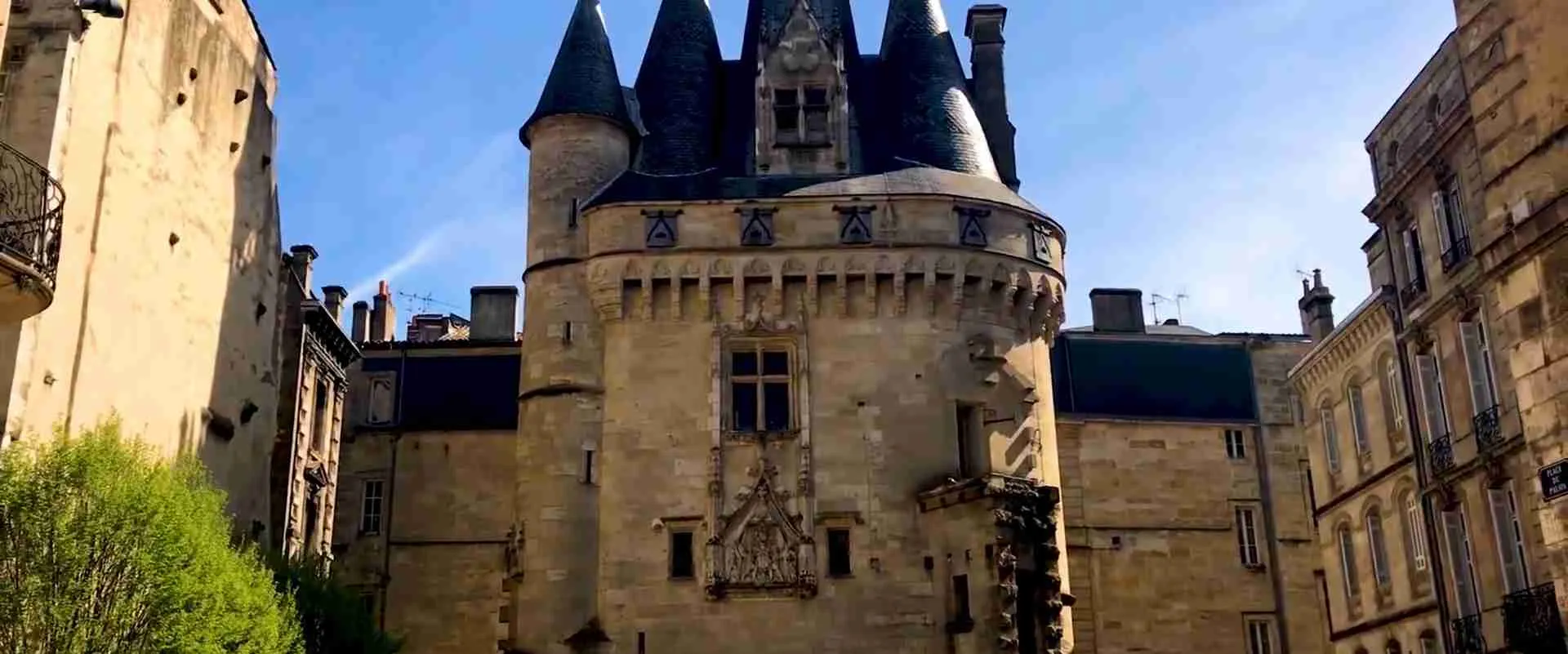
The Great Bell Belfry is the historic belfry of the city and a surviving piece of the medieval civic landscape. It shows what the town looked like before the Enlightenment replanning. The Cailhau Gate, on the square called Place du Palais, was the grand entrance from the river into the medieval city. It dates from the late fifteenth century and commemorates the victory of King Charles VIII at the Battle of Fornovo in Italy, though some guidebooks misname the king. Seen together, the belfry and the gate illustrate the medieval port town that the eighteenth-century planners later opened to the Garonne.
The Burgundy Gate
The Burgundy Gate is a stand-alone triumphal-style gate set at the eastern end of the old centre. It was designed in the 1750s by Ange-Jacques Gabriel and was originally named the Dauphine Gate in honor of the heir to the throne. Gabriel’s gate is a small compact statement of the Enlightenment style: an urban entrance conceived as a monument, in contrast to the fortified medieval gates it replaced.
The Pont de Pierre
The Pont de Pierre was the first bridge across the Garonne at Bordeaux. Napoleon, passing through the city in 1808, is said to have been struck by the difficulty of crossing the river with troops, and the bridge was decided in 1810 and inaugurated on 1 May 1822 under Louis XVIII. It is roughly 486 meters long, with 17 arches resting on 16 piers, and it links the old centre to the right-bank district called La Bastide. The structure is built of brick and stone, and one account says a British diving bell was borrowed to help set the foundations in the tidal river.
A popular story says that the 17 arches match the number of letters in the name Napoleon Bonaparte. Local sources treat this as a legend or coincidence rather than a documented design intention. The bridge was the only crossing between the two banks for about a century and a half. Since 2003 a tram line crosses it, and in recent years it has been closed to private cars and reserved for public transport, cycles and pedestrians. A multi-year program of consolidation has been announced because the piers are sinking a few millimeters each year into the river bed, so visitors should check current access.
The Quinconces Esplanade and the Girondins Monument
North of the Grand Théâtre lies the Quinconces Esplanade, a vast open space on the river side. At its western end stands the Girondins Monument, a column about 43 meters high topped by a figure of Liberty breaking her chains. It commemorates the Girondin deputies of the Revolution, whose name derives from the Gironde department. The esplanade is a reminder that Bordeaux’s classical city was planned with generous public open space as well as buildings.
The Public Garden and Intendance Avenue
The Public Garden, associated with the mid-eighteenth-century improvements, and Intendance Avenue, which links the area of the theatre to the Gambetta square, belong to the same planning legacy. Walking along these routes lets you see the Enlightenment city as a network of linked spaces rather than a set of single monuments.
The Aquitaine Museum
The Aquitaine Museum retraces the history of the region from prehistory to the modern period and is the best single place to see how the city’s heritage fits into a longer story. It includes displays on the Gallo-Roman city, the medieval and early modern port and Atlantic commerce, and it is a natural companion to the walk through the monuments.
How Does Bordeaux’s Architecture Express Classical and Neoclassical Style?
Bordeaux’s architecture expresses classicism through repetition: uniform stone façades with regular rhythms, pilasters, balconies and carved decoration repeated along entire streets. The UNESCO text describes this as an exceptional urban and architectural unity and coherence, with early eighteenth-century plans and ensembles establishing an outstanding example of innovative classical and neoclassical trends. The style is less about individual masterpieces than about the discipline of the whole.
The classical façade vocabulary
The ornamental repertoire first applied on Place de la Bourse became a template for the city. It includes engaged columns set into the wall, mascarons above the windows, scrolled rocaille detail and wrought-iron balconies. French writers on the square note that its façades became the model of the classical city, and the same elements recur on the quays, in the merchants’ mansions and along the avenues. The effect is of an architectural language shared by hundreds of buildings, each slightly different but obviously related.
From baroque to neoclassical
The city shows a visible change in taste across the eighteenth century. The earlier work around Place de la Bourse belongs to the elegant French classical tradition of the royal architects, while Victor Louis’s Grand Théâtre represents the later neoclassical turn toward strict colonnades and archaeological reference. Visitors can read this change by walking from the river square to the theatre. The sequence runs from the courtly composition of the quay to the civic temple of the later century.
Limestone, color and cleaning
The warm pale limestone that dominates the historic centre gives Bordeaux its uniform tone. Many façades darkened with pollution over the twentieth century, and cleaning campaigns in recent decades restored the lighter tone seen today. UNESCO’s recognition of the municipality’s effort to restore the quays and façades reflects this work. For photographers, the stone responds strongly to light: it glows in late afternoon and appears flatter under overcast skies.
Ironwork, urban furniture and the nineteenth century
The Committee’s wording says the values of the ensemble continued up to the first half of the twentieth century. That timeline includes the nineteenth-century bridge, the later railway and port structures, the Garonne quays and the industrial warehouses. In other words, the heritage does not stop with the Enlightenment. The Pont de Pierre, the industrial port of the right bank, and the early twentieth-century metal swing bridge that was lost in 2007 are all parts of the longer story.
How to read an ensemble
For visitors, the useful method is to look along the street rather than at the single building. Notice how cornice lines continue, how window heights align, how balconies repeat, and where a modern addition breaks the rhythm. These details are exactly what the management system tries to protect, and they are the reason the inscription covers the whole city rather than a short list of monuments.
Which Heritage Districts Lie Beyond the Historic Centre?
Beyond the historic centre, the heritage of the Port of the Moon continues north into the Chartrons district and the former Wet Docks, and across the river into La Bastide. These areas show the working port and the later industrial city, and they are where much of the modern regeneration has taken place.
The Chartrons district
The Chartrons developed as the quarter of wine merchants and shippers, with long quays, warehouses and merchants’ houses set close to the river. The district’s name is traditionally connected to a Carthusian monastery that once stood nearby. Today it is known for antique shops, galleries and a relaxed neighborhood atmosphere, and it is the natural place to study the commercial side of the port through the Bordeaux Wine and Trade Museum.
The Wet Docks (Bassins à flot) and Bacalan
North of the Chartrons, two large inland basins fed by the Garonne form the Wet Docks, a historic maritime zone that is now a mixed residential and cultural quarter. The area includes the Submarine Base, built by the German occupying forces between 1941 and 1943, and the eighteenth-century buildings known as the Marine Provisions Warehouses (Magasins aux Vivres de la Marine). The Submarine Base now houses the Bassins des Lumières, a large digital art centre that opened in 2020 and is described as the largest of its kind in the world.
Nearby, the Cité du Vin opened in June 2016. It is a wine museum and cultural centre whose rounded form evokes wine swirling in a glass, and it has an observation platform with views over the river. It is a contemporary landmark rather than an inscribed heritage building, but it shows how Bordeaux has reinterpreted its wine heritage in the former port zone. Visitors should confirm on the official boundary map whether a given site lies inside the inscribed area, since the northern port zone sits at the edge of the property and was the focus of planning attention after inscription.
La Bastide and the right bank
Across the Pont de Pierre, La Bastide shows the industrial side of the port, which developed on the right bank in the nineteenth century according to the nomination file. The right-bank waterfront offers the best vantage point for seeing the full curve of the left-bank façade, which is a reason many photographers cross the river at sunset.
Why the districts matter to the heritage story
These districts show that the Port of the Moon is a working harbor landscape. The warehouses, basins and industrial buildings explain how goods moved, how merchants lived and how the port functioned, and the later regeneration shows how a historic city can adapt its docklands without losing their identity.
How Has Bordeaux Managed Conservation Since Inscription?
Bordeaux has managed conservation since inscription through a mix of national protection, municipal planning and an expert local committee, and the process has included disputes with the World Heritage Committee. The most important episodes concern the loss of a historic swing bridge in 2007 and the construction of new bridges over the Garonne.
The Pertuis swing bridge and the Committee’s concern
Shortly after inscription, a metal swing bridge built in 1911 between two wet docks was demolished in December 2007 because the port authority considered it to be in poor condition. UNESCO’s documents describe the structure as a contributor to the property’s outstanding universal value, and the State Party later apologized for the demolition, acknowledging that it should have been valued as a heritage attribute. A related concern was a proposed new bridge across the Garonne, whose visual impact on the port entrance and townscape worried the advisory bodies.
Reinforced monitoring
In 2008 the World Heritage Committee urged the State Party to consider requesting inscription of the property on the List of World Heritage in Danger and decided to apply a reinforced monitoring mechanism. A joint World Heritage Centre and ICOMOS mission examined the situation. In 2009 the Committee regretted that the impacts of the replacement bridge had not been assessed beforehand and requested consistent planning rules for the entire property including the wet-dock area. It also asked for consideration of restoring the narrowed passage channel to its original size, and it asked that the façade of a former wine warehouse be retained rather than demolished.
The local committee and planning rules
In response, a Local UNESCO Bordeaux Committee made up of heritage experts was established in January 2009 to review planning applications that might affect the property. The city and the urban community stated that they would rely on this body for major restorations or new construction. The State Party also reported an objective, under the Urban Plan Bordeaux 2030, of restoring the canal to its original width from 2020.
Ongoing structural work
Conservation is also physical. The Pont de Pierre is the clearest case: its piers sink slowly into the river bed, and a multi-year consolidation program has been planned for the late 2020s. The work is an example of how a monument can require continuous engineering as well as protection by law.
What this means for visitors
For travelers, the conservation story offers a lens for reading the city. Construction cranes, temporary barriers or altered traffic around the bridge are part of the ongoing process of managing a living heritage city, and they illustrate why continued attention matters.
How Does Bordeaux Compare With Other UNESCO Historic Port Cities?
Bordeaux invites comparison with several World Heritage port cities, each of which protects a different kind of maritime heritage. The comparisons help explain what is distinctive about the Port of the Moon.
- Liverpool, Maritime Mercantile City was inscribed in 2004 and removed from the World Heritage List in 2021 after the Committee concluded that development had damaged its value. The contrast shows how seriously waterfront redevelopment is judged, and it gives context to the attention Bordeaux received over its bridge projects.
- Le Havre, rebuilt by Auguste Perret after wartime destruction, was inscribed in 2005 as a modern urban reconstruction. It represents the twentieth-century port, whereas Bordeaux represents the Enlightenment port.
- Genoa, Le Strade Nuove and the system of the Palazzi dei Rolli, was inscribed in 2006 and highlights the palaces of a merchant republic, a different political model of port wealth.
- Valparaíso, the historic quarter of the seaport city, was inscribed in 2003 and shows a hillside port settlement shaped by nineteenth-century trade.
Among these cities, Bordeaux is distinctive for its scale and unity. Its classical riverfront and its inclusion of a very large part of an inhabited city set it apart from properties that protect a single quarter. It also differs by retaining its harbor function: UNESCO notes that the city has kept its original role as a city of exchange and commerce because of its port.
How Do Wine Heritage and Port Heritage Connect in Bordeaux?
Wine heritage and port heritage are intertwined in Bordeaux because the harbor was the outlet for the wine of the surrounding region, and the criteria for inscription cite both. UNESCO links the city’s exchange of human values to its role as capital of a world-famous wine region and to the importance of its port in commerce.
From claret exports to the modern wine trade
The medieval and early modern export of wine to England and northern Europe built the commercial base of the city. In the nineteenth century the wines of the region were formally ranked for the Paris Universal Exposition of 1855 in a classification that remains famous, a reminder that Bordeaux’s reputation was shaped as much by commercial organization as by vineyards. The Chartrons merchants and the warehouses along the quays were the infrastructure of this system.
Museums and interpretation
Two institutions help travelers connect the heritage and the product. The Bordeaux Wine and Trade Museum, in the Chartrons, interprets the commercial side of the business. The Cité du Vin, opened in 2016, offers a broader, international introduction to wine culture, and its interpretation covers the story of viticulture across the world over several millennia, not only Bordeaux’s own.
Nearby World Heritage sites for context
Two other World Heritage properties lie within day-trip range and complement a Bordeaux visit. The Jurisdiction of Saint-Émilion, inscribed in 1999, is a cultural landscape of vineyards and a medieval town. The Fortifications of Vauban, inscribed in 2008, include the Citadel of Blaye on the Gironde estuary, which shows the defensive side of the same river system. Both help explain how the port, the vineyards and the estuary form one connected landscape.
How Should You Explore Bordeaux’s UNESCO Heritage on Foot?
The best way to explore the UNESCO heritage of Bordeaux is on foot, following a loop that starts at the river and returns to the centre. The historic core is compact, tram lines connect the main areas, and the flat terrain makes walking easy.
A one-day walking sequence
- Start at Place de la Bourse and the Water Mirror to see the riverfront composition, ideally in morning light.
- Walk south along the quays toward the Cailhau Gate and the Great Bell Belfry to see the medieval layer.
- Continue inland to Saint-André Cathedral and the Pey-Berland Tower, and look at the Rohan Palace beside them.
- Walk to the Grand Théâtre along Intendance Avenue, then continue to the Quinconces Esplanade and the Girondins Monument.
- Return along the quays and cross the Pont de Pierre, if open, or view it from the left bank, to see the façade from the opposite shore.
A second day for districts and museums
A second day can be devoted to the Chartrons, the Wet Docks and the Cité du Vin, with the Aquitaine Museum and Saint-Michel Basilica as indoor alternatives. The Bassins des Lumières and the Submarine Base fit into the same northern itinerary.
Reading the city from the water
River cruises operate on the Garonne and provide the view that the eighteenth-century planners intended, the long curve of façades seen from the water. A cruise also explains the name Port of the Moon, because the crescent is easiest to understand from the river.
Best light and conditions for photography
The Water Mirror gives its best reflections when the surface is calm, and the limestone glows at the end of the day. The right bank offers the sweeping view of the quays, and the interiors of the cathedral reward a midday visit. Because the city has a temperate oceanic climate, rain showers are possible in any season, and a flexible plan helps.
What Practical Tips Help Visitors Respect Bordeaux’s Living Heritage?
Visitors respect Bordeaux’s living heritage by treating the historic center as a residential city: moving carefully through crowded squares, following signs for protected areas, and using public transport. The inscription covers inhabited streets, so the same spaces serve as homes, shops and workplaces.
Getting around
The tram network serves the main heritage areas, including a stop near the cathedral at the Hôtel de Ville, and the first tram line opened in 2003. The Pont de Pierre is reserved for buses, cycles and pedestrians, and the city is well suited to cycling. The main tourist office stands close to Place de la Bourse and provides current maps and boundary information. Check operating details with official sources before travel, as hours and access change.
Etiquette at monuments and in the Water Mirror
The Water Mirror is shallow and designed for people to walk in, but the surrounding stone of the square should be treated with care. Churches remain active places of worship, so quiet and modest dress are appropriate. Climbing towers involves narrow spiral staircases, which may not suit every visitor.
Reading interpretation with care
Because some of the city’s history involves colonial trade and slavery, visitors will find that interpretation varies between sites. The Aquitaine Museum is a reliable starting point for a fuller account, and local guides specializing in the heritage of the port can add context.
Combining Bordeaux with the wider region
Bordeaux works well as a base for exploring the vineyards and the estuary. The city’s rail connections and the nearby World Heritage landscapes make it practical to combine the Port of the Moon with Saint-Émilion and the Gironde estuary.
Frequently Asked Questions
Is the whole city of Bordeaux a UNESCO World Heritage Site?
No, but a very large part of it is. The inscribed property covers 1,731 hectares of the historic city, which is often described as roughly two-fifths of the municipal area, and a larger buffer zone surrounds it. The property includes the historic centre, the quays, the Chartrons and parts of the port zone. Areas outside the boundary, including many outer suburbs and the newest districts, are not inscribed. Because local sources quote slightly different figures for the extent of the property and the associated attention zone, the most reliable source for the exact boundary is the official map published by the World Heritage Centre and the city.
When was Bordeaux inscribed on the World Heritage List?
Bordeaux, Port of the Moon was inscribed in 2007 at the thirty-first session of the World Heritage Committee, held in Christchurch, New Zealand, from 23 June to 2 July. French academic sources give 28 June 2007 as the date of the decision. The property carries the reference number 1256. It was inscribed as a cultural property, and the Committee based its decision on criteria (ii) and (iv).
Which UNESCO criteria apply to Bordeaux, Port of the Moon?
Criteria (ii) and (iv) apply. Criterion (ii) recognizes the exchange of human values over more than two thousand years, linked to the city’s role as capital of a famous wine region and to the commerce of its port. Criterion (iv) recognizes an outstanding urban and architectural ensemble created in the Age of Enlightenment, with values that continued into the first half of the twentieth century. UNESCO also notes that the city has retained its original port function as a place of exchange and commerce.
Why is Place de la Bourse so important to the World Heritage story?
Place de la Bourse is the symbolic beginning of the Enlightenment city. It was the first major breach in the medieval ramparts, opened by the intendant Claude Boucher, and it was built from about 1730 by the royal architects Jacques Gabriel and Ange-Jacques Gabriel. The square gave the city a monumental face toward the river and set the pattern of façades that spread through the centre. Together with the Water Mirror added in 2006, it is the most photographed view of the property and the best place to begin a visit.
What is the Water Mirror and how deep is it?
The Water Mirror is a shallow reflecting pool laid out in 2006 on the quay in front of Place de la Bourse. It is designed by the landscape architect Michel Corajoud and consists of a granite surface covered by a film of water about two centimeters deep. Sources give its area as roughly 3,450 square meters and describe it as the largest reflecting pool of its kind. Mist is released several times an hour, so the view alternates between reflection and fog. It is safe for children because of its shallow depth.
Was the Bordeaux World Heritage status ever at risk?
The status faced serious scrutiny shortly after inscription. In December 2007 a historic metal swing bridge was demolished in the port area, and a new bridge project across the Garonne raised concerns. In 2008 the World Heritage Committee urged the State Party to consider requesting inscription on the List of World Heritage in Danger and applied reinforced monitoring. In 2009 it asked for consistent planning rules across the property, and a local expert committee was created in January 2009. These steps focused on protecting the port quarter and have shaped how new projects are assessed.
Are the Cité du Vin and the Bassins des Lumières part of the UNESCO site?
They stand in the northern port area, which sits at the edge of the inscribed property and was a focus of planning attention after inscription. The Cité du Vin, opened in 2016, and the Bassins des Lumières, opened in 2020 inside the Submarine Base, are contemporary cultural attractions rather than historic monuments of the original nomination. The Submarine Base itself was built between 1941 and 1943. For exact boundary questions, consult the official map, since the property and its buffer zone do not follow the visitor’s sense of a district.
How are the three Bordeaux churches on the Santiago de Compostela routes related to the Port of the Moon?
They belong to a separate World Heritage listing. Saint-André Cathedral, Saint-Michel Basilica and Saint-Seurin Basilica form part of the Routes of Santiago de Compostela in France, which was inscribed in 1998. The Port of the Moon was inscribed in 2007 for the urban and architectural ensemble. The two listings overlap geographically but recognize different values: pilgrimage heritage in the first case and the exchange and Enlightenment city in the second.
How long does it take to see the UNESCO heritage of Bordeaux?
One full day is enough to walk the principal monuments of the historic centre: Place de la Bourse, the quays, the gates, the cathedral quarter, the Grand Théâtre and the Quinconces Esplanade. A second day allows time for the Aquitaine Museum, the Chartrons, the Wet Docks and the Cité du Vin. Travelers interested in architecture, wine history or the Atlantic trade can easily spend a third day on museums and river views, and a short excursion to Saint-Émilion adds regional context.
Which other World Heritage sites can be combined with a Bordeaux visit?
The Jurisdiction of Saint-Émilion, inscribed in 1999, is a vineyard landscape with a medieval town and is the most common companion trip. The Fortifications of Vauban, inscribed in 2008, include the Citadel of Blaye on the Gironde estuary. Within Bordeaux itself, the three pilgrimage-route churches add a second layer of designation. Together these places show how the port, the wine country, the estuary and the pilgrimage roads fit into one regional heritage landscape.