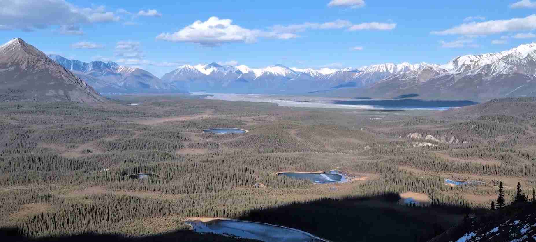
Wrangell-St. Elias National Park: Complete UNESCO Guide
Wrangell-St. Elias National Park forms the American cornerstone of the world’s largest internationally protected mountain ecosystem, designated as a UNESCO World Heritage Site in 1979 as part of the Kluane / Wrangell-St. Elias / Glacier Bay / Tatshenshini-Alsek transnational property. At 13.2 million acres, this Alaskan wilderness preserves the convergence of four major mountain ranges, the largest concentration of glaciers and peaks above 16,000 feet in North America, and continues an unbroken chain of protection extending across the Alaska-Canada border.
Key Takeaways
- Transnational UNESCO Site: Wrangell-St. Elias was inscribed in 1979 as part of a four-park international World Heritage property spanning Alaska and northwestern Canada, extended in 1992 and 1994 to encompass 24 million acres of protected wilderness
- Largest Non-Polar Icefield: The transnational site contains the largest non-polar icefield in the world, with Wrangell-St. Elias contributing massive glacial systems including Malaspina Glacier, North America’s largest piedmont glacier, and Hubbard Glacier, Alaska’s longest tidewater glacier
- Extreme Vertical Relief: The park contains some of the highest coastal relief on Earth, with peaks rising from sea level to 18,008 feet within 10 miles, creating spectacular landscapes shaped by active plate tectonics, volcanism, and ongoing glaciation
- Outstanding Universal Value: UNESCO recognized the property under criteria vii, viii, ix, and x for its superlative natural phenomena, active geological processes, ongoing ecological evolution, and significant biodiversity including critical habitat for grizzly bears, caribou, and Dall sheep
- Living Cultural Landscape: The park preserves 10,000 years of continuous Indigenous occupation by Ahtna Athabascan and coastal Tlingit peoples, along with significant early 20th century copper mining heritage at Kennecott
- Wilderness Designation: Two-thirds of the park, encompassing 9.1 million acres, is designated as the Wrangell-St. Elias Wilderness, the largest single wilderness area in the United States, ensuring permanent protection of pristine natural processes
People Also Ask About Wrangell-St. Elias UNESCO Heritage
Why is Wrangell-St. Elias a UNESCO World Heritage Site?
Wrangell-St. Elias was designated a UNESCO World Heritage Site in 1979 as part of the Kluane / Wrangell-St. Elias / Glacier Bay / Tatshenshini-Alsek transnational property. UNESCO recognized the site for containing the largest non-polar icefield in the world, the most spectacular glaciers on the continent, and exceptional examples of active tectonic, volcanic, and glacial processes. The property demonstrates Outstanding Universal Value through its superlative natural beauty, ongoing geological processes that shape the landscape, evolving ecological systems from coastal rainforests to alpine tundra, and critical habitat for significant wildlife populations including grizzly bears, caribou, and Dall sheep that face threats elsewhere.
What makes the Wrangell-St. Elias UNESCO site unique?
The Wrangell-St. Elias UNESCO World Heritage property is unique as the first binational site on the World Heritage List, establishing a precedent for international cooperation in wilderness conservation. The site encompasses the convergence of four distinct mountain ranges, creating North America’s greatest concentration of peaks above 16,000 feet. Its position at the junction of tectonic plates produces ongoing mountain building, active volcanism, and extreme glaciation simultaneously, allowing observation of fundamental Earth processes in action. The property also protects the entire elevational gradient from tidewater to 18,008-foot summit, preserving complete ecosystem transitions from coastal marine environments through temperate rainforests to arctic-alpine tundra within a single protected area.
How does Wrangell-St. Elias relate to other parks in the UNESCO site?
Wrangell-St. Elias National Park forms the southeastern Alaska component of a four-park transnational UNESCO site that spans the Alaska-Yukon-British Columbia border region. The park shares its eastern boundary with Canada’s Kluane National Park and Reserve, creating a continuous 20-million-acre protected area. Glacier Bay National Park lies to the south, connected through the Tongass National Forest and sharing marine ecosystems. Tatshenshini-Alsek Provincial Park in British Columbia links the system, with the Tatshenshini and Alsek rivers providing critical ice-free migration corridors between coastal and interior biogeoclimatic zones. This integration creates the world’s largest internationally protected mountain ecosystem, ensuring genetic exchange and seasonal migration for wide-ranging species like grizzly bears and caribou.
What UNESCO criteria does Wrangell-St. Elias meet?
Wrangell-St. Elias meets four UNESCO natural criteria for Outstanding Universal Value. Criterion vii recognizes superlative natural phenomena including the world’s largest non-polar icefield, massive calving glaciers, the highest coastal relief on Earth, and breathtaking wilderness landscapes of exceptional beauty. Criterion viii acknowledges ongoing geological processes including active plate tectonics building the St. Elias Mountains, volcanic activity from the Pacific Ring of Fire, and spectacular examples of glaciation and landscape modification. Criterion ix covers ongoing ecological and biological evolution, from primary succession on recently deglaciated terrain to mature coastal rainforests, demonstrating ecosystem development at multiple scales. Criterion x identifies the property as containing critical natural habitats for significant biodiversity, including viable populations of species threatened elsewhere such as grizzly bears, caribou, and Dall sheep in their natural ranges.
Extended multi-day tours – 5+ days
Featured Alaska Multi-Day Tour Packages

3 days
Alaska 3-Day Discovery Tour
- ✓ Comprehensive Alaska experience
- ✓ Expert local guides included
- ✓ All accommodation included
- ✓ Transportation provided
5 days
Alaska 5-Day Highlights Experience
- ✓ Comprehensive Alaska experience
- ✓ Expert local guides included
- ✓ All accommodation included
- ✓ Transportation provided
7 days
Alaska 7-Day Cultural Journey
- ✓ Comprehensive Alaska experience
- ✓ Expert local guides included
- ✓ All accommodation included
- ✓ Transportation provided

10 days
Alaska 10-Day Complete Adventure
- ✓ Comprehensive Alaska experience
- ✓ Expert local guides included
- ✓ All accommodation included
- ✓ Transportation provided
Multi-day tour packages powered by TourRadar. Prices and availability subject to change.
Introduction
Wrangell-St. Elias National Park and Preserve stands as the largest unit in the United States National Park System and forms the centerpiece of the world’s most extensive internationally protected wilderness. Inscribed as a UNESCO World Heritage Site in 1979 as part of the Kluane / Wrangell-St. Elias / Glacier Bay / Tatshenshini-Alsek transnational property, this 13.2-million-acre Alaskan wilderness preserves one of Earth’s most dramatic geological laboratories. The park encompasses the convergence of four major mountain ranges, the greatest concentration of high peaks in North America, the largest assemblage of glaciers on the continent, and ecosystems ranging from Pacific tidewater to arctic-alpine summits within a span of less than 50 miles.
The UNESCO designation recognizes Wrangell-St. Elias for values that transcend national boundaries and represent natural heritage of significance to all humanity. The property’s Outstanding Universal Value derives from its exceptional geological processes, extraordinary biodiversity, and superlative natural beauty. Here, active plate tectonics continue to build the tallest coastal mountains on Earth while massive glaciers carve valleys and deposit moraines. Volcanic forces manifest through steaming fumaroles on Mount Wrangell, and the collision between the Pacific and North American plates creates ongoing seismic activity and mountain uplift. These fundamental Earth processes operate at scales and intensities found in few other places on the planet.
The property’s ecological significance equals its geological importance. The Wrangell-St. Elias region supports complete elevational gradients from sea level to 18,008 feet, preserving intact ecosystem transitions rarely found within single protected areas. Coastal temperate rainforests dominated by Sitka spruce and western hemlock transition to boreal forests of white spruce and balsam poplar, ascending through alpine shrublands to arctic-alpine tundra at higher elevations. This diversity creates habitat for species assemblages ranging from marine mammals and seabirds to interior caribou and Dall sheep, with grizzly bears, wolves, and wolverines ranging across multiple ecosystem types.
Understanding Wrangell-St. Elias requires recognizing its role within the larger transnational UNESCO property. The park does not exist in isolation but forms the southwestern component of a wilderness complex that extends across international boundaries. To the east, Canada’s Kluane National Park and Reserve protects the northern St. Elias Mountains and Mount Logan, Canada’s highest peak. Southward, Glacier Bay National Park preserves tidewater glaciers and marine ecosystems. British Columbia’s Tatshenshini-Alsek Provincial Park links the system, with the Tatshenshini and Alsek rivers creating vital wildlife corridors. Together, these four protected areas form a 24-million-acre wilderness, the largest internationally coordinated conservation area in the world.
The human dimension adds additional layers to the property’s significance. Archaeological evidence documents 10,000 years of continuous human occupation, with Ahtna Athabascan peoples inhabiting the interior river valleys and coastal Tlingit communities utilizing marine and lower elevation resources. This Indigenous presence continues to the present, with subsistence harvesting of fish, game, and plants forming essential elements of cultural identity and food security for Alaska Native communities. The early 20th century brought industrial copper mining to the region, leaving the remarkably preserved Kennecott mill complex as a monument to Alaska’s mining era and now a National Historic Landmark within the park.
Wrangell-St. Elias challenges conventional notions of national park accessibility and management. Unlike most American parks with extensive road systems and developed facilities, Wrangell-St. Elias preserves wilderness character through minimal infrastructure. Only two unpaved roads penetrate the park’s 13.2 million acres, and vast areas remain accessible solely by aircraft, river, or on foot. This remoteness protects natural processes from human disruption while demanding self-sufficiency and wilderness skills from visitors. The park’s management philosophy balances preservation of wilderness values with recognition of ongoing subsistence practices and the small communities of McCarthy and Kennecott within park boundaries.
This guide explores Wrangell-St. Elias National Park through the lens of its UNESCO World Heritage status. The following sections examine the geological forces that created these mountains and glaciers, the ecological systems they support, the cultural heritage they preserve, and the international cooperation required to protect them. Understanding these elements reveals why UNESCO recognized this landscape as possessing Outstanding Universal Value worthy of protection for all humanity, and why the transnational property continues to serve as a model for international wilderness conservation.
The Transnational UNESCO World Heritage Property
The Kluane / Wrangell-St. Elias / Glacier Bay / Tatshenshini-Alsek UNESCO World Heritage property represents a pioneering achievement in international conservation. Inscribed in 1979 with initial components in Alaska and Yukon, the property expanded through extensions in 1992 and 1994 to include Glacier Bay National Park and Tatshenshini-Alsek Provincial Park, creating the first binational site on the World Heritage List. This designation established a precedent for coordinated cross-border protection of ecosystems that transcend political boundaries, recognizing that natural processes and wildlife populations operate at landscape scales requiring international cooperation.
The transnational property spans the Alaska-Yukon-British Columbia border region, encompassing approximately 24 million acres of protected wilderness. Four national parks and protected areas form the core: Wrangell-St. Elias National Park and Preserve in Alaska, Kluane National Park and Reserve in Yukon, Glacier Bay National Park and Preserve in Alaska, and Tatshenshini-Alsek Provincial Park in British Columbia. Additional wilderness areas, including the Wrangell-St. Elias Wilderness and designated wilderness in Glacier Bay, provide enhanced protection within the larger parks. This integration creates the world’s largest internationally protected mountain ecosystem and the most extensive conservation area in the circumpolar north.
The property’s boundaries follow natural features rather than arbitrary lines. The St. Elias Mountains form the central spine, extending from Glacier Bay in the southeast through Wrangell-St. Elias and into Kluane, where they reach their highest elevation at 19,551-foot Mount Logan, Canada’s tallest peak and the second highest mountain in North America. The Chugach Mountains define the southwestern extent in Wrangell-St. Elias, while the Wrangell Mountains mark the northwestern boundary. The coastal zone extends to tidewater at Glacier Bay and along portions of the Wrangell-St. Elias coastline, preserving complete elevational gradients from sea level to the continent’s highest coastal peaks.
River systems provide critical linkages within the transnational property. The Tatshenshini and Alsek rivers flow from interior Yukon through the St. Elias Mountains to the Pacific Ocean, creating ice-free corridors that allow plant and animal migration between coastal and interior biogeoclimatic zones. These riverine connections proved essential to the property’s Outstanding Universal Value designation, as they enable genetic exchange and seasonal movement for wide-ranging species like grizzly bears and caribou. The Copper River performs similar functions in Wrangell-St. Elias, draining interior Alaska and providing salmon migration routes that support both wildlife and Indigenous subsistence economies.
Management of the transnational property requires coordination among multiple jurisdictions. In the United States, the National Park Service administers Wrangell-St. Elias and Glacier Bay under the authority of the Organic Act of 1916 and specific enabling legislation for each park. Parks Canada manages Kluane National Park and Reserve in cooperation with the Champagne and Aishihik First Nations, while British Columbia Parks oversees Tatshenshini-Alsek Provincial Park. Regular meetings between management agencies address common challenges including climate change impacts on glaciers, wildlife population dynamics, and visitor safety in remote wilderness environments.
The transnational designation brings both opportunities and complexities. Shared UNESCO status strengthens justification for conservation funding and attracts international scientific research. Joint management planning addresses issues like grizzly bear population monitoring, which requires data collection across international boundaries since bears range freely between Alaska and Canada. Climate change research benefits from the property’s north-south extent, allowing comparison of glacial recession rates and ecosystem responses across latitudinal gradients. However, differences in national policies on subsistence hunting, mineral development, and wilderness preservation sometimes create tensions requiring diplomatic resolution.
Understanding Wrangell-St. Elias within the transnational context reveals the park’s role as part of a larger ecological system rather than an isolated protected area. Caribou herds migrate between Alaska and Yukon. Grizzly bears born in Kluane may spend portions of their lives in Wrangell-St. Elias. Glaciers that originate in one country flow across borders into another. The property’s Outstanding Universal Value derives not from individual features but from the integration of diverse ecosystems, geological processes, and wildlife populations into a functioning whole. This recognition of landscape-scale conservation represents UNESCO’s most important contribution to protecting the St. Elias mountain region.
Outstanding Universal Value and UNESCO Criteria
UNESCO’s recognition of the Kluane / Wrangell-St. Elias / Glacier Bay / Tatshenshini-Alsek property rests on demonstrating Outstanding Universal Value through specific criteria. The transnational site meets four natural criteria, making it one of the most comprehensively significant natural World Heritage properties. Understanding these criteria illuminates why UNESCO considers this wilderness of global importance deserving protection for all humanity.
Criterion vii: Superlative Natural Phenomena and Exceptional Beauty
The transnational property encompasses some of Earth’s most spectacular mountain and glacier landscapes. The site contains the largest non-polar icefield in the world, with approximately 250 cubic miles of ice covering mountain slopes and valley floors. Individual glaciers reach extraordinary dimensions: Malaspina Glacier in Wrangell-St. Elias spreads across 1,500 square miles, larger than the state of Rhode Island and the largest piedmont glacier in North America. Hubbard Glacier extends 76 miles from its source near the Alaska-Yukon border to tidewater at Yakutat Bay, making it Alaska’s longest tidewater glacier and one of the few advancing glaciers in Alaska.
The mountains themselves create landscapes of exceptional beauty. Nine of the sixteen highest peaks in the United States rise within the property, including 18,008-foot Mount St. Elias at the Alaska-Yukon border, 18,009-foot Mount Logan in Kluane, and 17,400-foot Mount Foraker. These peaks rise from near sea level to extreme heights within horizontal distances of less than 10 miles, creating some of the highest coastal relief on Earth. The visual impact of this vertical relief exceeds that of the Himalayas in certain locations, with glaciated peaks soaring directly above tidewater fjords and Pacific beaches.
Active processes enhance the landscape’s dynamism. Massive calving glaciers discharge icebergs into tidewater bays at Glacier Bay and Icy Bay, creating spectacular displays as house-sized ice blocks crash into the ocean. The Hubbard Glacier periodically surges, advancing across the entrance to Russell Fjord and transforming the fjord into a temporary lake before ice dam failure releases catastrophic floods. Volcanic activity manifests through steaming fumaroles near the summit of 14,163-foot Mount Wrangell, where geothermal heat melts snow to create ice caves within the summit caldera. These ongoing processes demonstrate nature’s power at scales that humble human presence.
The property’s wilderness character amplifies its aesthetic values. Visitors encounter landscapes essentially unmodified by human development, with natural processes dominating vast areas. The absence of roads, structures, or other human artifacts across millions of acres allows appreciation of wilderness in its most pristine state. Night skies display the aurora borealis without light pollution, while silence broken only by wind, wildlife, and calving glaciers creates sensory experiences increasingly rare in the modern world. These qualities of solitude and wildness form essential elements of the property’s exceptional beauty.
Criterion viii: Outstanding Geological Processes and Earth History
The transnational property provides exceptional examples of ongoing geological processes that shape Earth’s surface. The site’s position astride the boundary between the Pacific and North American tectonic plates creates active mountain building through crustal deformation and uplift. The Fairweather Fault, running through Glacier Bay and along the coast, represents the transform boundary where the Pacific Plate slides northwest relative to the North American Plate at approximately two inches per year. This movement generates frequent earthquakes, including the magnitude 7.9 Lituya Bay earthquake of 1958 that triggered a landslide producing the tallest tsunami wave ever recorded at 1,720 feet.
Volcanism adds another dimension to the property’s geological significance. The Wrangell Volcanic Field, part of the Pacific Ring of Fire, includes several major volcanoes. Mount Wrangell maintains active fumaroles that melt ice and create steam plumes visible from aircraft. Mount Drum, Mount Sanford, and Mount Blackburn show evidence of past volcanic activity within the last 100,000 years. Mount Churchill last erupted approximately 1,200 years ago, producing the White River Ash that buried forests and grasslands across eastern Alaska and Yukon, preserved today in visible white bands in river cutbanks throughout the region.
Glaciation represents the property’s most visible geological process. The site contains examples of nearly every type of glacier: valley glaciers flowing down mountain canyons, hanging glaciers clinging to steep slopes, cirque glaciers occupying mountain bowls, piedmont glaciers spreading across lowlands, tidewater glaciers calving into the ocean, and surging glaciers that periodically advance at rates up to 100 feet per day. The diversity and scale of glacial features within the property exceed those found anywhere else at similar latitudes, making the site an invaluable outdoor laboratory for studying glacial processes and climate responses.
The landscape records past glacial cycles with exceptional clarity. Terminal moraines mark former glacier extents, showing positions from the Little Ice Age maximum around 1750 and earlier advances. Deglaciated valleys expose glacial polish on bedrock surfaces, erratics transported by ice, and striations showing ice flow directions. Glacier Bay itself provides a textbook example of landscape evolution following ice retreat: when Captain George Vancouver explored the area in 1794, a single massive glacier filled what is now a 65-mile-long bay; today, researchers study primary succession on terrain exposed by ice retreat over the past 230 years, documenting ecosystem development from bare rock to mature forest in real time.
Mineral resources demonstrate the property’s complex geological history. The Kennecott copper deposits in Wrangell-St. Elias formed through hydrothermal processes associated with volcanism, creating some of the richest copper ore ever discovered with concentrations reaching 70 percent pure copper in certain seams. Gold deposits drew prospectors to the region during the Klondike Gold Rush. These mineral concentrations result from millions of years of tectonic activity, magmatic intrusions, and metamorphic processes, making the property valuable for understanding ore deposit formation.
Criterion ix: Ongoing Ecological and Biological Processes
The transnational property demonstrates ecological and biological evolution at multiple scales. Primary succession on recently deglaciated terrain provides opportunities to observe ecosystem development from initial colonization through progressive stages. At Glacier Bay, researchers have documented succession sequences as glaciers retreat: pioneer species like Sitka alder establish first, fixing nitrogen and preparing soil for later arrivals. Cottonwood and willow follow, then Sitka spruce and western hemlock establish, eventually creating mature temperate rainforest. This progression occurs over timescales of decades to centuries, allowing observation of processes that normally require millennia.
The property protects complete elevational gradients encompassing coastal marine, temperate rainforest, boreal forest, alpine shrubland, and arctic-alpine tundra communities. These transitions preserve intact ecosystem sequences rarely found within single protected areas. Coastal zones support kelp forests, intertidal communities, and seabird colonies. Temperate rainforests dominated by Sitka spruce and western hemlock receive over 100 inches of annual precipitation and achieve biomass levels among the highest on Earth. Interior valleys support white spruce and balsam poplar forests adapted to cold continental climates. Alpine areas above treeline host communities of low shrubs, sedges, and lichens similar to arctic tundra despite their location at temperate latitudes.
River corridors facilitate ecological connections. The Tatshenshini and Alsek rivers create ice-free migration corridors allowing movement of both species and genetic material between coastal and interior biogeoclimatic zones. Salmon runs connect marine and terrestrial ecosystems, transporting marine-derived nutrients hundreds of miles inland where bear predation and carcass decomposition fertilize riverside forests. These nutrient transfers support higher plant productivity and larger wildlife populations than would occur without anadromous fish, demonstrating the connectivity between seemingly separate ecosystems.
The property’s size ensures that ecological processes operate at natural scales. Wildfire cycles function without suppression across extensive areas, creating mosaic landscapes of different successional stages that support diverse wildlife communities. Predator-prey dynamics involving wolves, grizzly bears, caribou, moose, and Dall sheep operate without human intervention. Large carnivores maintain territories measured in hundreds of square miles without encountering park boundaries. These landscape-scale processes increasingly rare in fragmented ecosystems demonstrate how natural systems function when given sufficient space.
Criterion x: Significant Biodiversity and Conservation Value
The transnational property supports exceptional biodiversity and provides critical habitat for species of conservation concern. Grizzly bear populations thrive throughout the property, with densities in coastal areas supported by salmon reaching among the highest in Alaska. Interior populations range across vast territories, following seasonal food sources from valley bottoms where they graze on emerging vegetation in spring, to alpine slopes where they excavate ground squirrels in summer, to salmon streams in fall. The property’s size allows bears to maintain natural ranging behaviors and population structures without conflict with human development.
Dall sheep find optimal habitat in the property’s extensive alpine and subalpine terrain. Populations in Wrangell-St. Elias, Kluane, and surrounding areas represent some of the most robust in Alaska and Yukon. The sheep utilize different elevations seasonally: higher alpine areas in summer where predation risk decreases, lower slopes in winter where wind-scoured ridges provide access to vegetation beneath snow. Mineral licks attract large gatherings, and traditional lambing areas see consistent use across generations, demonstrating site fidelity to specific locations within the larger landscape.
Caribou utilize different portions of the property during annual migration cycles. The Chisana caribou herd ranges across the northwestern portions of Wrangell-St. Elias and into adjacent Canadian territory. Seasonal movements take herds from winter ranges in forested valleys to summer calving grounds and alpine feeding areas, then back to winter habitats. These migrations require unobstructed travel corridors and intact habitats at multiple locations, both provided by the property’s extensive protected wilderness.
Marine and coastal ecosystems support specialized wildlife assemblages. Harbor seals haul out on ice floes calved from tidewater glaciers. Steller sea lions utilize remote beaches and offshore rocks for breeding colonies. Humpback whales feed in nutrient-rich waters where upwelling and glacial discharge create productivity hotspots. Seabird colonies on coastal cliffs and islands include black-legged kittiwakes, common murres, and tufted puffins. These species depend on marine ecosystems protected within the property’s coastal zones, particularly at Glacier Bay where regulations limit vessel traffic and noise in critical feeding and breeding areas.
The property provides habitat for species threatened or at risk in other portions of their ranges. Wolverines, requiring large territories and low human disturbance, thrive in the property’s wilderness. Lynx populations cycle with snowshoe hare abundance in boreal forests. Trumpeter swans, once reduced to remnant populations, breed successfully in protected wetlands. These conservation values demonstrate the property’s role in maintaining viable populations of species that face increasing pressures elsewhere from habitat loss, climate change, and human development.
Geological Foundations: Tectonics, Volcanism, and Glaciation
Understanding Wrangell-St. Elias National Park requires understanding the fundamental geological processes that created and continue to shape this landscape. Three forces dominate: plate tectonics building mountains, volcanism adding height and complexity, and glaciation sculpting valleys and peaks. These processes operate simultaneously, creating a dynamic landscape where creation and destruction occur in real time.
Plate Tectonics and Mountain Building
The St. Elias Mountains owe their existence to the collision and subduction of tectonic plates along the southern Alaska coast. The Pacific Plate moves northwest relative to the North American Plate at approximately two inches per year, generating three distinct types of plate boundaries within the region. Along the coast near Glacier Bay, the Fairweather Fault represents a transform boundary where plates slide past each other horizontally, generating frequent earthquakes. Further west and north, the Pacific Plate subducts beneath the North American Plate, diving into the mantle and creating the Alaska Subduction Zone. This subduction drives volcanic activity in the Wrangell Mountains and generates massive thrust faults that push rock masses upward to build mountains.
The resulting mountain building creates exceptional vertical relief. Mount St. Elias rises from sea level to 18,008 feet within a horizontal distance of less than 10 miles, achieving one of the highest coastal relief ratios on Earth. Mount Logan in adjacent Kluane National Park reaches 19,551 feet, making it the tallest mountain in Canada and the second highest peak in North America. The rapid elevation gain results from ongoing crustal deformation: measurements using GPS show portions of the St. Elias Mountains rising at rates exceeding one centimeter per year, among the fastest uplift rates measured anywhere on the planet.
This rapid uplift competes with erosion through glaciers, creating a dynamic equilibrium. Glaciers erode rock through plucking and abrasion, transporting enormous volumes of sediment to lower elevations. The Malaspina Glacier alone carries an estimated 10 billion tons of rock debris incorporated into its ice. Yet despite this massive erosion, the mountains continue growing because tectonic uplift exceeds glacial erosion rates. The balance between construction through tectonics and destruction through glaciation maintains the landscape’s basic configuration while constantly modifying details.
Earthquakes provide direct evidence of ongoing tectonic activity. The magnitude 9.2 Great Alaska Earthquake of 1964, centered in Prince William Sound west of the park, affected the Wrangell-St. Elias region through ground shaking and tectonic adjustments. More recent earthquakes include the magnitude 7.9 Denali Fault earthquake of 2002, which ruptured the surface along the Denali Fault for 209 miles, including portions traversing the northern park boundary. These seismic events demonstrate that mountain building continues actively, with the landscape responding to tectonic forces operating on human timescales.
Wrangell Volcanic Field and Pacific Ring of Fire
The Wrangell Mountains constitute the northern extension of the Pacific Ring of Fire, a zone of active volcanism encircling the Pacific Ocean. Unlike the explosive stratovolcanoes of the Alaska Peninsula and Aleutian Islands, the Wrangell volcanoes are massive shield volcanoes built through repeated lava flows creating gently sloping mountains of enormous volume. Mount Wrangell itself rises to 14,163 feet and contains three craters near its summit, with the North Crater hosting active fumaroles that emit steam and volcanic gases year-round.
The volcanic field’s age and activity span millions of years. The oldest Wrangell volcanoes erupted during the Miocene epoch approximately 26 million years ago. Activity continued episodically, with major eruptions constructing Mount Drum, Mount Sanford, and Mount Blackburn during the Pleistocene epoch of the last two million years. Mount Churchill, located along the Alaska-Yukon border, last erupted approximately 1,200 years ago, producing massive ashfalls that buried vegetation across eastern Alaska and Yukon. The White River Ash, a distinctive white layer visible in river cutbanks throughout the region, preserves evidence of this eruption and provides a chronological marker for dating landscape changes.
Mount Wrangell remains the only currently active volcano in the field, though its activity consists of fumarolic emissions rather than lava eruptions. Steam rising from the North Crater melts overlying ice, creating cavern systems within the summit icecap that provide shelter for research camps. Temperature measurements within the ice caves record heat flow from the underlying magma chamber, while gas sampling reveals sulfur compounds and carbon dioxide indicating active volcanic processes beneath the surface. The volcano’s quiescent state may represent a pause between eruptive phases rather than permanent dormancy, as geological evidence suggests eruptions occurred as recently as several thousand years ago.
Volcanic landforms add diversity to the landscape beyond the major peaks. Basaltic lava flows form extensive plateaus in portions of the park, with columnar jointing creating hexagonal rock columns as cooling magma contracted. Volcanic debris flows called lahars carved valleys and deposited mixed sediments of volcanic rock and glacial material. Volcanic ash layers interbedded with glacial deposits provide chronological markers allowing researchers to determine relative ages of glacial advances and retreats. This integration of volcanic and glacial features creates geological complexity found in few other locations.
North America’s Greatest Glacier Concentration
Wrangell-St. Elias National Park contains the largest concentration of glaciers in North America, with thousands of named and unnamed glaciers covering approximately 25 percent of the park’s area. These glaciers range from small cirque glaciers occupying mountain bowls to massive valley and piedmont glaciers extending tens of miles. The diversity of glacier types within the park makes it an invaluable natural laboratory for studying glacial processes and responses to climate change.
Malaspina Glacier represents the park’s most distinctive glacial feature. This piedmont glacier flows from multiple valley glaciers in the St. Elias Mountains and spreads across lowlands adjacent to the coast, covering approximately 1,500 square miles. The glacier’s surface displays complex folded patterns called looped moraines, created as tributary glaciers carrying different rock types merge and flow together. These patterns resemble abstract artwork visible from aircraft, with alternating bands of light and dark debris creating striking visual displays. Despite its massive size, Malaspina Glacier remains relatively unknown compared to Alaska’s tidewater glaciers because its terminus lies inland from the coast rather than calving directly into the ocean.
Hubbard Glacier flows 76 miles from its source near the Alaska-Yukon border to tidewater at Yakutat Bay, making it Alaska’s longest tidewater glacier and one of the few advancing glaciers in Alaska. The glacier’s terminus stands nearly 400 feet tall where it meets the ocean, calving house-sized icebergs that drift into Disenchantment Bay. Hubbard Glacier periodically surges, advancing across the entrance to Russell Fjord and transforming the fjord into a freshwater lake before ice dam failure releases catastrophic floods. These surge events occurred in 1986 and 2002, temporarily blocking the fjord entrance and raising water levels by 60 feet before the ice dam collapsed.
Nabesna Glacier extends approximately 80 miles from its source near Mount Blackburn to its terminus south of the park boundary, making it one of the longest valley glaciers in North America. The glacier drains a vast accumulation area in the Wrangell Mountains, flowing down a broad valley that provides relatively easy access for researchers studying glacier dynamics. Monitoring shows the glacier thinning and retreating in response to regional climate warming, with the terminus withdrawing several miles from its Little Ice Age maximum position marked by terminal moraines dating to approximately 1850.
Bagley Ice Field spans approximately 127 miles along the Chugach Mountains, forming the largest subpolar ice field in North America. This massive accumulation zone feeds numerous outlet glaciers including Bering Glacier, the largest glacier in North America located just west of the park boundary. The ice field receives enormous snowfall from Pacific storms, accumulating hundreds of inches of snow annually that compresses into glacial ice. Research drilling through the ice field reveals ice thickness exceeding 3,000 feet in places, representing thousands of years of accumulated snowfall compressed into solid ice.
Ecosystems and Biodiversity
The extraordinary elevational range within Wrangell-St. Elias National Park creates habitat diversity supporting species assemblages from coastal marine environments to arctic-alpine tundra. The park’s 13.2 million acres encompass nearly complete elevational gradients, with ecosystems transitioning from sea level at Icy Bay to 18,008 feet at Mount St. Elias summit. This diversity makes the park critical for wildlife requiring multiple habitat types during annual cycles and for species reaching the limits of their geographic or elevational ranges.
Coastal and Marine Ecosystems
The park’s coastal zone along the Gulf of Alaska supports productive marine ecosystems driven by nutrient-rich waters from glacial discharge and oceanic upwelling. Cold, nutrient-laden water supports abundant phytoplankton, forming the base of food webs that sustain fish, seabirds, and marine mammals. Tidewater glaciers like Hubbard Glacier create unique conditions where ice calving generates turbulence that brings nutrients from depth to the surface, supporting dense concentrations of krill and other zooplankton that attract humpback whales and other predators.
Harbor seals use ice floes calved from tidewater glaciers as haul-out platforms for resting and pupping. These seals demonstrate specialized adaptations for utilizing glacial environments, with pupping occurring on ice floes that provide protection from terrestrial predators while offering easy access to marine foraging areas. Populations in Icy Bay and Disenchantment Bay represent important concentrations, with hundreds of seals utilizing ice habitats during spring and summer months. Climate-driven reductions in ice availability raise concerns about habitat loss for this species as glaciers retreat.
Seabird colonies utilize coastal cliffs, offshore rocks, and islands within the park’s coastal zone. Black-legged kittiwakes nest in colonies numbering thousands of pairs, building nests on narrow cliff ledges above the ocean. Common murres and pelagic cormorants share similar nesting habitat, while tufted puffins excavate burrows on grassy slopes of offshore islands. These colonial nesters depend on marine fish populations for feeding their chicks, with colony success tied to ocean productivity and fish availability. Researchers monitor seabird colonies as indicators of marine ecosystem health, with breeding success reflecting broader oceanographic conditions.
Temperate Rainforest and Coastal Forest
Temperate rainforest dominated by Sitka spruce and western hemlock occurs in the park’s coastal regions receiving abundant precipitation from Pacific storms. These forests achieve remarkable biomass levels, with trees reaching heights exceeding 150 feet and diameters of several feet. Heavy precipitation, mild temperatures, and foggy conditions create environments where lichens, mosses, and ferns coat every available surface, giving the forest an emerald appearance. Fallen logs support seedlings in a process called nurse log succession, where decomposing wood provides nutrients and moisture for establishing trees.
The forest floor supports limited understory vegetation due to dense canopy cover restricting light penetration. Devil’s club, a spiny shrub with large palmate leaves, dominates in openings and along streams. Blueberry bushes provide important bear food in late summer. Skunk cabbage emerges early in spring in wet areas, its yellow flowers producing heat that melts surrounding snow. These understory species create structural diversity supporting varied wildlife communities, from roosting bats to foraging bears.
Salmon streams penetrate temperate rainforests, connecting marine and terrestrial ecosystems. Five species of Pacific salmon spawn in park rivers: sockeye, coho, chinook, chum, and pink salmon. These anadromous fish spend most of their lives in the ocean, returning to freshwater streams to spawn and die. Their carcasses transfer marine-derived nutrients hundreds of miles inland, where decomposition releases nitrogen and phosphorus that fertilize riverside forests. Research shows that trees near salmon streams grow faster and achieve larger sizes than trees distant from salmon inputs, demonstrating the importance of this nutrient subsidy.
Interior Boreal Forest and River Valleys
Interior valleys of the Chitina, Copper, and Nabesna rivers support boreal forest communities dominated by white spruce and black spruce. These ecosystems experience continental climate patterns with cold winters, short summers, and lower precipitation than coastal regions. White spruce forests occupy well-drained slopes and floodplains, while black spruce dominates poorly drained wetlands where permafrost creates waterlogged soils. Balsam poplar and paper birch provide deciduous elements, creating fall color when leaves turn yellow in September.
Understory vegetation varies with drainage and successional stage. Mature spruce forests support sparse understory with mosses and low shrubs including Labrador tea and crowberry. Recent burns or floodplain succession areas host dense willow and alder thickets. Berry-producing shrubs including blueberry, cranberry, and soapberry provide crucial food for bears, moose, and songbirds. Wildflowers including fireweed, lupine, and wild geranium add summer color to openings and disturbed areas.
Riparian zones along braided glacial rivers create specialized habitats. These rivers carry heavy sediment loads from glacial erosion, depositing gravels and sands across broad floodplains. Vegetation colonizes recently deposited bars in succession sequences: pioneer willows establish first, then cottonwoods and alders, eventually succeeded by spruce if flooding frequency decreases. This dynamic creates mosaics of different-aged vegetation supporting diverse wildlife. Arctic terns nest on gravel bars, ptarmigan utilize willow thickets, and moose browse on riparian shrubs.
Alpine and Tundra Communities
Alpine areas above treeline, occurring around 2,500 to 3,500 feet depending on latitude and exposure, support tundra communities dominated by low shrubs, sedges, grasses, and lichens. These environments resemble arctic tundra despite temperate latitudes, with similar adaptations to short growing seasons, permafrost, and harsh conditions. Dwarf birch, willow species, and heather create shrub layers inches to feet tall. Sedge meadows occupy wetter sites, while dry ridges support lichen communities including reindeer lichens that provide critical winter forage for caribou.
Alpine wildflower displays attract attention during brief summers. Mountain avens produce white flowers emerging from cushion-forming plants. Alpine azalea, moss campion, and saxifrage species add colors including pink, purple, and yellow. Timing varies with elevation and aspect, with south-facing slopes blooming weeks earlier than north-facing areas at similar elevations. Peak bloom typically occurs in July, attracting pollinating insects including bumblebees and flies that constitute the primary pollinators at high elevations.
Wildlife utilization of alpine areas follows seasonal patterns. Dall sheep occupy alpine and subalpine terrain year-round, using steep slopes that provide escape terrain from predators. Grizzly bears move to alpine areas in summer, grazing on herbaceous vegetation and excavating ground squirrels. Caribou utilize alpine ridges where wind-scoured areas provide access to lichens beneath shallow snow in winter. Ptarmigan inhabit alpine willow thickets, changing plumage from summer brown to winter white for camouflage. These elevational migrations create patterns where species utilize different elevations at different seasons, requiring large protected areas to maintain complete habitat sequences.
Glacier and Periglacial Environments
Glaciers and surrounding periglacial environments support limited but specialized biodiversity. Ice worms, small segmented worms reaching lengths of several millimeters, inhabit glacier surfaces where they feed on windblown pollen, algae, and organic particles deposited on ice. These worms move vertically within surface ice layers, descending deeper during daytime to avoid lethal temperatures above freezing and ascending at night to feed. Ice worm populations can reach densities of thousands per square meter, making them among the most abundant large organisms on glacier surfaces.
Snow algae create visible coloration on snowfields and glacier surfaces. Red algae called watermelon snow produces pink or red coloration in late-season snow. Green algae grows in surface melt pools, while brown algae creates darker patches. These algae photosynthesize using sunlight penetrating ice, providing organic matter that supports bacteria and other microscale organisms. Research suggests algae growth may accelerate glacier melting by darkening surface ice and reducing reflectivity, creating feedback loops where increased algae abundance causes faster melting which provides more liquid water supporting more algae growth.
Recently deglaciated terrain supports primary succession as plants colonize bare rock and sediment exposed by retreating glaciers. Pioneer species including dwarf fireweed, mountain avens, and Dryas species establish first, tolerating harsh conditions and low nutrient availability. Nitrogen-fixing plants like alder improve soil fertility, enabling later successional species to establish. Lichens colonize rock surfaces, beginning weathering processes that eventually create soil from bedrock. These succession sequences provide natural experiments where researchers study ecosystem development from bare substrate to mature vegetation communities.
Large Mammal Populations
Grizzly bears occupy all major ecosystems within the park except permanently ice-covered areas. Interior populations range across vast territories measured in hundreds of square miles, following seasonal food sources including emerging vegetation in spring, ground squirrels in summer, and berries in fall. Coastal populations concentrate along salmon streams during spawning runs, with individual bears consuming dozens of salmon daily to accumulate fat reserves for winter hibernation. Denning occurs in excavated dens on steep slopes, typically above 3,000 feet elevation where snow accumulation provides insulation. Cubs born during winter den period remain with mothers for two to three years, learning foraging skills and territory use.
Dall sheep populations inhabit alpine and subalpine terrain throughout the Wrangell and St. Elias mountains. These white-coated sheep demonstrate specialized adaptations for cliff dwelling, with exceptional balance allowing use of steep rocky slopes that exclude most predators. Populations segregate by sex outside breeding season, with rams occupying higher, more rugged terrain while ewes and lambs utilize slightly lower elevations with better forage. Breeding occurs in November, with rams competing through head-butting displays. Lambs born in May and June face high predation from golden eagles and coyotes, with approximately half surviving their first year.
Moose occupy forested valleys and riparian areas, browsing on willows, birch, and aquatic vegetation. Bulls grow massive antlers exceeding 60 inches in width, shed annually in winter and regrown during summer. Cows produce one to two calves in spring, hidden in dense vegetation for the first weeks of life. Wolves prey on moose throughout the year, with highest success rates targeting calves in spring and weakened adults in winter. Deep snow favors wolves over moose by restricting moose mobility while wolves travel atop crusted snow, shifting predator-prey dynamics with annual snowpack variations.
Caribou utilize different portions of the park during seasonal migrations. The Chisana caribou herd ranges across northwestern areas of the park, with population estimates around several thousand animals. Seasonal movements take herds from winter ranges in boreal forest to alpine calving areas in spring, then to summer feeding areas before returning to winter habitats. These migrations require unobstructed travel corridors, with human developments like roads potentially disrupting traditional routes. Climate change affects caribou through altered vegetation patterns, changing insect harassment periods, and modified snow conditions influencing access to winter forage.
Indigenous Heritage and Cultural Landscapes
Human occupation of the Wrangell-St. Elias region extends at least 10,000 years, making it one of the longest continuously inhabited landscapes in Alaska. Archaeological evidence documents seasonal camps, hunting sites, and permanent settlements across elevational gradients from coastal areas to alpine passes. This deep Indigenous history reflects sophisticated knowledge of ecological patterns and resource distribution, with seasonal rounds utilizing different environments as resources became available.
Ahtna Athabascan Interior Adaptations
The Ahtna Athabascan people occupied interior valleys of the Copper River and its tributaries for millennia before European contact. Ahtna territory encompassed most of what is now Wrangell-St. Elias National Park, with distinct bands associated with major river drainages. The Tatl’ah’ina band utilized the upper Chitina River drainage, the Dze’nanida’a occupied the lower Chitina, and the Kohnina ranged along the Copper River above the confluence with the Chitina. Each band maintained traditional use areas with boundaries recognized through custom and kinship ties.
Subsistence economies combined fishing, hunting, and plant gathering in seasonal rounds. Salmon runs in the Copper and Chitina rivers provided crucial food resources, with families establishing fish camps along productive sections of river during spawning runs. Caribou hunting occurred during fall migrations, with hunters intercepting herds at traditional crossing points. Moose provided meat and hides throughout the year. Dall sheep hunting in alpine areas required multi-day expeditions to high country. Plant gathering included berries, roots, and spruce cambium, with specific locations known for abundant resources visited annually.
Traditional knowledge systems encoded understanding of ecological patterns accumulated across generations. Elders taught younger generations how to read weather signs, predict animal movements, and locate resources across vast landscapes. Place names in the Ahtna language recorded important features: fishing sites, hunting camps, travel routes, and spiritual locations. These naming systems created mental maps transmitting landscape knowledge orally. Many traditional place names persist today, with locations like Batzulnetas, Tanada, and Nabesna preserving Ahtna language in official usage.
Trade networks connected Ahtna groups with coastal Tlingit communities and interior Athabascan bands. Copper from the Chitina River drainage provided trade goods exchanged for coastal resources including eulachon oil and shells. Trade routes crossed mountain passes connecting interior and coastal regions, with trails following ridgelines that avoided dense forest travel. The Valdez-Eagle Trail utilized by early Euro-American prospectors followed traditional Indigenous routes, demonstrating the efficiency of travel corridors developed through centuries of use.
Tlingit Coastal Connections
Coastal Tlingit communities occupied shorelines and lower river valleys along the Gulf of Alaska, with the Yakutat Tlingit Tribe maintaining traditional territory including coastal portions of what is now Wrangell-St. Elias National Park. Tlingit society organized around clan systems with matrilineal inheritance, complex social hierarchies, and sophisticated artistic traditions. Winter villages featured large plank houses accommodated extended families, while seasonal camps supported summer fishing and gathering activities.
Marine resources dominated Tlingit subsistence economies. Salmon spawning in coastal rivers provided abundant food resources, with fish preserved through smoking and drying for winter consumption. Halibut fishing occurred in nearshore waters, with specialized hooks designed to target these large bottom-dwelling fish. Sea otters, harbor seals, and sea lions provided meat, fur, and oil. Intertidal zones yielded shellfish, seaweed, and other marine resources. Herring and eulachon spawning runs provided oil rendered from fish, a valuable food and trade commodity.
Trade relationships connected coastal Tlingit with interior Ahtna groups through mountain passes. The Tlingit controlled access to European trade goods obtained from Russian and later American traders, exchanging these manufactured items for copper and furs from interior groups. The Chilkat Blanket Trail and other passes through the St. Elias Mountains carried traders despite challenging terrain and weather. These connections created interdependence where neither coastal nor interior groups operated in isolation, with specialized resources from different regions circulating through trade networks.
Subsistence Continuity and Alaska Native Claims Settlement Act
Traditional subsistence practices continue within Wrangell-St. Elias National Park through provisions of the Alaska National Interest Lands Conservation Act that established the park in 1980. Congress recognized that Alaska Natives and rural residents depend on subsistence harvesting of fish and wildlife for nutritional, economic, and cultural survival. ANILCA mandates subsistence priority on federal lands in Alaska, protecting traditional practices within national parks subject to conservation principles.
Contemporary subsistence activities include hunting caribou, moose, and Dall sheep; fishing for salmon and other species; trapping furbearers including marten and lynx; and gathering plants and berries. These practices maintain cultural continuity, transmit traditional knowledge to younger generations, and provide food security in remote communities where store-bought food costs substantially more than urban Alaska. Subsistence users demonstrate detailed ecological knowledge enabling sustainable harvests, with traditional practices including avoiding certain areas during wildlife sensitive periods and utilizing all portions of harvested animals.
The Alaska Native Claims Settlement Act of 1971 created Native corporations receiving land and monetary compensation for extinguishing aboriginal land claims. The Ahtna Corporation holds title to approximately 1.77 million acres within and adjacent to Wrangell-St. Elias National Park, creating a complex land ownership pattern. Ahtna Corporation manages its lands for economic development including natural resource extraction, while also supporting cultural preservation and employment for Alaska Native shareholders. This ownership structure means that activities prohibited on park lands may occur on adjacent Ahtna lands, requiring coordination between the National Park Service and Native corporations.
Government-to-government relationships between the National Park Service and federally recognized tribes influence park management. Wrangell-St. Elias National Park maintains formal agreements with the Cheesh’na Tribal Council, Mentasta Traditional Council, and Yakutat Tlingit Tribe. These agreements establish consultation processes ensuring tribal voices influence decisions affecting traditional territories and resources. Cooperative management addresses issues including subsistence regulations, cultural site protection, and interpretation of Indigenous history. This collaborative approach recognizes Indigenous rights and knowledge as essential elements of park management rather than obstacles to conservation.
Copper Mining Heritage and the Kennecott Legacy
Industrial copper mining transformed portions of the Wrangell-St. Elias region during the early 20th century, leaving a legacy of historic structures and environmental impacts that complicate wilderness preservation. The Kennecott Mines, located in the heart of what is now the national park, produced some of the richest copper ore ever discovered and contributed to Alaska’s economic development. Understanding this mining heritage provides context for balancing preservation of natural and cultural resources.
Discovery and Development
Copper mineralization in the Chitina River drainage became known to outsiders through Indigenous knowledge, with Ahtna people using native copper for tools and trade goods for centuries. The first documented Euro-American discovery occurred in 1900 when prospectors Jack Smith and Clarence Warner observed green copper staining on Bonanza Ridge. Subsequent investigation revealed extraordinary ore bodies with copper concentrations reaching 70 percent in the richest seams, compared to typical copper ore grades of 1-2 percent.
The Kennecott Copper Corporation, controlled by the Guggenheim family and J.P. Morgan financial interests, acquired the mining claims and developed infrastructure to extract and transport ore. The remoteness presented formidable challenges: the mines sat 200 miles from the nearest port at Cordova, across mountainous terrain with no roads or railroads. The corporation invested over $100 million, equivalent to billions in current dollars, to construct the Copper River and Northwestern Railway connecting the mines to tidewater. This engineering achievement required bridging the Copper River multiple times, cutting grades through steep terrain, and building in permafrost areas and active avalanche zones.
The mill complex at Kennecott processed ore using gravity concentration methods that separated copper minerals from waste rock. Multi-story buildings housed crushing equipment, concentration tables, and loading facilities, with ore moved between processing stages using gravity rather than mechanical conveyors. The engineering efficiency reduced operational costs, making profitable extraction possible despite high transportation expenses. Supporting infrastructure included worker housing, a hospital, school, recreation hall, and electrical power plant, creating a self-sufficient community in wilderness isolation.
Production and Economics
The Kennecott Mines operated from 1911 to 1938, producing over 591,000 tons of copper and 9 million ounces of silver. Peak production occurred during World War I when copper demand for electrical wiring and brass cartridges drove prices higher. The mines employed approximately 500 to 600 workers during operational periods, with labor sourced from diverse backgrounds including European immigrants, Alaska Natives, and workers from the American West. Wages exceeded those available in most rural Alaska locations, attracting workers willing to endure isolation and challenging conditions.
Transportation costs dominated the economic equation. Ore traveled by railroad from Kennecott to Cordova, then by ship to Tacoma smelters in Washington state. This journey covered thousands of miles, with each step adding expense. Only the exceptional ore quality made mining profitable under these conditions. When easily accessible high-grade ore depleted and copper prices declined during the Great Depression, operations became uneconomical. The corporation closed the mines in 1938, removing valuable equipment but leaving buildings and infrastructure in place.
Preservation as National Historic Landmark
The abandoned Kennecott mill complex deteriorated slowly in Alaska’s dry interior climate, with buildings remaining relatively intact decades after closure. Recognition of the site’s historical significance led to National Historic Landmark designation in 1986, acknowledging Kennecott as an exceptionally well-preserved example of early 20th century copper mining and milling technology. This designation preceded national park establishment by six years, creating protection mandates carried into park management.
The National Park Service faces unique challenges preserving Kennecott’s structures. Traditional preservation approaches stabilizing buildings in original condition conflict with Alaska’s harsh climate causing ongoing deterioration. Wood structures settle and shift with ground movement. Snow loads collapse roofs. Wind damages exposed metal siding. The Park Service employs stabilization techniques that arrest deterioration while maintaining historic appearance, avoiding reconstruction that would create false historical representations. This preservation philosophy accepts that buildings will show age while preventing catastrophic collapse.
Public access to Kennecott creates tensions between preservation and visitation. The site’s remote location, reached only by unpaved road and footbridge crossing the Kennecott River, limits visitor numbers compared to accessible parks. However, increased visitation creates wear on historic structures from foot traffic, touching wooden surfaces, and inadvertent damage. The Park Service offers guided tours through mill buildings, controlling access while providing interpretation. Independent exploration requires visitors to understand risks inherent in entering deteriorating industrial structures, with signage warning of hazards including unstable floors and falling debris.
Environmental Legacy and Mine Reclamation
Historic mining operations left environmental impacts including mine waste, mill tailings, and contaminated sites. The National Park Service conducted environmental assessments identifying locations with elevated heavy metal concentrations in soil and water. Cleanup priorities focus on areas posing risks to human health or ecosystem function. Some contamination remains in place where remediation costs outweigh benefits, with institutional controls preventing exposure rather than removing all contaminated materials.
Modern perspectives on Kennecott acknowledge both historical significance and environmental impacts. The mines represent important elements of Alaska’s economic development, technological innovation, and labor history. The well-preserved structures provide tangible connections to industrial heritage. Simultaneously, the mining operation extracted resources from Indigenous lands, disrupted ecosystems, and left pollution requiring ongoing management. This complexity resists simple narratives, requiring acknowledgment of multiple perspectives on the mining legacy within a national park dedicated to wilderness preservation.
Conservation Challenges and Climate Change
Managing Wrangell-St. Elias National Park involves addressing conservation challenges operating at multiple scales. Climate change drives accelerating glacier retreat, vegetation changes, and wildlife distribution shifts. Wilderness character faces pressures from increasing visitation and technological changes enabling access to previously remote areas. Balancing preservation mandates with recognition of Indigenous rights and ongoing subsistence uses requires continuous negotiation. Understanding these challenges provides context for park management decisions affecting the property’s Outstanding Universal Value.
Glacier Retreat and Landscape Transformation
Climate warming drives rapid glacier recession throughout the park, with most glaciers thinning and retreating from positions reached during the Little Ice Age around 1750-1850. Repeat photography comparing current glacier positions with historical images shows dramatic changes: valley glaciers that reached lowland forests now terminate miles upvalley; piedmont glaciers that spread across coastal plains have fragmented into separate lobes; icefields that fed multiple outlet glaciers have thinned by hundreds of feet. These changes occur on timescales of decades, making them observable within human lifespans.
Measurements using aircraft-based laser altimetry quantify ice loss rates. Studies show that glaciers in the St. Elias Mountains lost ice at accelerating rates between 2000 and 2020, with average thinning exceeding three feet per year across large glaciers. Total ice volume loss from the region contributes measurably to global sea level rise, with the St. Elias glaciers among the largest non-polar contributors to ocean volume increase. Projections suggest continued rapid loss through the 21st century, with some models predicting 80-90 percent loss of current ice volume by 2100 under high-emissions scenarios.
Glacier retreat triggers cascading ecosystem changes. Streams fed by glacial meltwater experience altered flow regimes, with peak flows shifting from late summer to earlier in the season as accumulation zones diminish. Water temperatures in glacially-fed streams increase as ice volume decreases, affecting salmon and other cold-water species. Vegetation colonizes recently deglaciated terrain, creating opportunities to study primary succession while transforming formerly ice-covered areas into vegetated landscapes. These changes occur rapidly enough that researchers observe ecosystem transitions across their careers rather than inferring processes from static observations.
Permafrost Degradation and Landscape Stability
Permafrost underlies much of the park’s northern areas, with permanently frozen ground extending hundreds of feet below the surface in some locations. Rising temperatures drive permafrost thaw, with the active layer that freezes and thaws seasonally deepening while permanently frozen ground thaws from both surface and base. Thawing permafrost destabilizes slopes, triggers landslides, and alters drainage patterns as ice lenses melt and ground subsides.
Thermokarst features form where permafrost degradation causes ground subsidence. Thaw lakes develop as ice-rich permafrost melts and ground collapses, creating depressions that fill with water. These lakes expand as thawing undermines banks, eventually draining catastrophically when thermal erosion breaches confining margins. The cycle of lake formation, expansion, and drainage creates pockmarked landscapes where flat terrain becomes irregular topography of lakes, drained basins, and remnant mounds of ice-cored ground. These processes accelerate as climate warms, transforming stable permafrost terrain into dynamic thermokarst landscapes.
Permafrost thaw affects infrastructure including the two unpaved roads accessing the park. The McCarthy Road and Nabesna Road cross areas underlain by ice-rich permafrost, with roadbeds settling as underlying ice melts. Maintenance challenges increase as permafrost degradation accelerates, requiring more frequent repairs to maintain passable conditions. Some sections may become unmaintainable if thaw progresses beyond feasible engineering solutions, potentially limiting future road access unless expensive reconstruction replaces permafrost-affected roadbeds with non-frost-susceptible materials.
Wildlife Responses to Environmental Change
Wildlife populations respond to climate-driven habitat changes through distribution shifts, altered timing of biological events, and in some cases, population declines. Dall sheep, adapted to cold alpine environments, face pressures from warming temperatures that may exceed thermal tolerance thresholds. Icing events where rain falls on snow and freezes create impenetrable crusts preventing access to vegetation, causing starvation during severe winters. Parasite and disease ranges expand northward and to higher elevations as warming moderates previously limiting cold temperatures.
Caribou populations fluctuate in response to complex factors including weather, predation, and habitat conditions, all influenced by climate change. Altered snow regimes affect access to winter forage, with deeper snow or ice-crusted snow restricting feeding. Warmer summers increase harassment from parasitic insects, forcing caribou to spend more time seeking relief and less time feeding. Vegetation changes driven by warming temperatures and altered fire regimes modify habitat quality, with shrub expansion into tundra potentially reducing lichen availability critical for winter survival. The Chisana caribou herd declined from several thousand animals to fewer than 1,000 in recent decades, with climate factors contributing to this decrease.
Grizzly bear phenology shifts as plant growth responds to earlier springs and longer growing seasons. Bears emerging from hibernation find vegetation greening earlier, requiring adjustments to traditional seasonal movement patterns. Salmon spawning timing may shift in response to altered stream temperatures and flow regimes, potentially creating mismatches where bears arrive at streams before or after peak salmon abundance. Berry production varies with weather during flowering and fruit development, affecting fall food availability when bears accumulate fat for winter. These phenological changes require behavioral plasticity, with bears capable of adjustment thriving while less adaptable individuals or populations facing challenges.
Fire Regime Changes
Climate warming increases wildfire frequency and intensity across Alaska, with the boreal forest in Wrangell-St. Elias experiencing more frequent large fires. Warmer temperatures dry fuels earlier and more thoroughly, lengthening fire seasons and creating conditions conducive to combustion. Lightning strike frequency appears to increase with warming, providing more ignition sources. The combination of drier fuels and more ignitions produces larger fires burning more acreage annually than in previous decades.
Fire plays a natural role in boreal forest ecology, with many species adapted to periodic burning. Black spruce forests accumulate flammable ground layers including mosses and lichens that carry fire, with mature spruce releasing seeds from cones opened by heat. Aspen and birch regenerate vigorously following fire, creating deciduous stands that gradually succeed back to spruce dominance over decades to centuries. However, increased fire frequency potentially alters successional patterns, with forests burning before reaching maturity and regenerating to different vegetation types.
The National Park Service allows natural wildfires to burn in designated fire management zones within the park, recognizing fire as an essential ecological process. Suppression focuses on protecting park structures, private property, and adjacent communities while allowing backcountry fires to play their natural role. This policy reflects scientific understanding that fire suppression disrupts natural cycles and creates fuel accumulation leading to more severe fires when they inevitably occur. Climate change complicates this approach by increasing fire intensity beyond historical ranges, raising questions about whether current fires remain within ecological norms or represent unprecedented disturbances.
Visiting Wrangell-St. Elias: Access and Experience
Experiencing Wrangell-St. Elias National Park requires preparation and self-sufficiency uncommon in more developed national parks. The park’s immense size, remote location, minimal infrastructure, and wilderness character create challenges and opportunities. Visitors willing to accept these conditions discover landscapes of exceptional beauty and wildness, with opportunities for solitude and adventure increasingly rare elsewhere.
Access and Transportation
The park has no entrance fee, reflecting limited infrastructure and services compared to parks with developed facilities. Two unpaved roads provide vehicle access: the McCarthy Road extending 60 miles from Chitina to the Kennecott River, and the Nabesna Road running 42 miles from the park boundary near Slana into the northern portions of the park. Both roads require careful driving, with gravel surfaces, washboard sections, narrow passages, and potential for flat tires from sharp rocks. Rental car agencies often prohibit driving on these roads, requiring private vehicles or specialized rentals accepting gravel road use.
Air access provides alternatives to road travel. Small aircraft equipped with wheels, floats, or skis reach locations inaccessible by road, with landing strips scattered across the park and off-airport landings permitted on suitable terrain. Flight-seeing tours from communities including McCarthy, Gulkana, and Yakutat offer aerial perspectives on glaciers and mountains. Air taxis transport backpackers to remote landing strips for multi-day wilderness trips, picking them up at predetermined locations and dates. This aircraft-dependent access pattern differs from most American parks, requiring familiarity with small plane travel and associated costs.
The historic Kennecott mill complex attracts most visitors, reached via the McCarthy Road and a footbridge across the Kennecott River. Private vehicles park on the west side of the river, with foot access across a bridge installed after the original road bridge washed out. A shuttle service transports visitors and luggage between the parking area and McCarthy-Kennecott communities five miles up the valley. This arrangement preserves the area’s character while managing vehicle impacts on the narrow dirt road connecting McCarthy and Kennecott.
Wilderness Recreation Opportunities
The park offers exceptional opportunities for wilderness recreation requiring self-sufficiency and navigation skills. Maintained trails remain limited, with most travel occurring cross-country across tundra, along glaciers, or through trackless forest. Backpacking trips range from day hikes near the road system to multi-week expeditions across remote mountain ranges. Navigation relies on map and compass or GPS, with visitors responsible for route-finding across terrain without marked paths. River crossings, glacier travel, and wildlife encounters require judgment and preparation, with mistakes potentially resulting in serious consequences given the park’s remoteness.
Mountaineering attracts climbers to challenging peaks including Mount Blackburn, Mount Sanford, and numerous unclimbed summits. Routes involve glacier travel, crevasse navigation, and high-altitude conditions, with weather changes creating avalanche danger and whiteout conditions reducing visibility to feet. Successful climbs require technical skills, appropriate equipment, and willingness to turn back when conditions deteriorate. The remoteness means rescue operations face significant challenges, with helicopter support dependent on weather and self-rescue often the only realistic option.
Rafting and kayaking on glacially-fed rivers provide opportunities to experience the park from a different perspective. The Copper River offers multi-day float trips through spectacular scenery, with camping on gravel bars and navigating around sweepers and logjams. The Chitina River presents more challenging whitewater, with braided channels requiring constant navigation and rapid currents demanding skilled boat handling. These trips require experience with wilderness river travel, self-sufficiency for extended periods, and acceptance of cold, silty water conditions characteristic of glacial streams.
Safety Considerations and Self-Sufficiency Requirements
Wrangell-St. Elias demands higher levels of self-sufficiency than developed parks. No cell phone coverage exists across most of the park, eliminating communication options that many visitors assume available. Emergency response faces significant challenges given the distances involved, with helicopter rescue dependent on weather conditions that often prevent flight during storms when emergencies most likely occur. Visitors must carry appropriate equipment, possess relevant skills, and make conservative decisions recognizing that help may not arrive quickly.
Wildlife encounters require awareness and appropriate behavior. Grizzly bears occur throughout the park, with food storage regulations mandating bear-resistant containers or hanging food beyond bear reach. Moose, despite herbivorous diet, pose danger particularly during calving season when cows aggressively defend calves, and during fall rut when bulls become unpredictable. River crossings present drowning risk in fast, cold, glacially-fed streams, with water levels fluctuating based on weather and glacial melt rates. Hypothermia threatens year-round given the potential for cold, wet conditions even in summer.
Weather conditions change rapidly and unpredictably. Clear morning skies can deteriorate to rain, snow, or fog within hours, with low clouds grounding aircraft and limiting visibility for navigation. Summer temperatures range from freezing to 80 degrees Fahrenheit, requiring layered clothing systems. Winter temperatures commonly reach minus 40 degrees Fahrenheit, with survival requiring appropriate cold-weather equipment and shelter. The park’s continental interior location creates weather patterns distinct from coastal Alaska, with less precipitation but more extreme temperature ranges.
Interpretive Programs and Cultural Resources
The Wrangell-St. Elias Visitor Center in Copper Center provides orientation through exhibits covering natural and cultural history, with rangers available to answer questions and provide trip planning assistance. Summer programs include ranger-led walks and evening presentations covering topics from glacial geology to Indigenous heritage. The center’s location on the Richardson Highway allows convenient access for travelers passing through the region, introducing the park to visitors who may not venture deeper into the backcountry.
Kennecott mill tours offer opportunities to explore the historic copper mining complex with interpretation explaining milling processes, living conditions, and social history of the mining era. Rangers lead tours through the multi-story concentration mill, explaining how gravity-fed ore processing separated copper minerals from waste rock. The tours provide context for understanding industrial heritage within a wilderness national park, presenting balanced perspectives on mining’s role in Alaska’s economic development and environmental impacts requiring ongoing management.
Cultural heritage interpretation addresses Indigenous history and ongoing connections to the land. Programs discuss 10,000 years of Ahtna Athabascan and Tlingit occupation, traditional subsistence practices, and how Alaska Native communities maintain cultural continuity despite colonization and modern economic pressures. Collaboration with tribal governments ensures accurate representation of Indigenous perspectives, moving beyond stereotypical historical presentations to acknowledge living cultures with continuing relationships to ancestral territories within park boundaries.
Research and Scientific Significance
Wrangell-St. Elias National Park functions as an outdoor laboratory where researchers study geological, ecological, and climate processes operating at scales and intensities found in few other locations. The park’s size, wilderness character, and position at the intersection of active tectonic, volcanic, and glacial processes create research opportunities unavailable in smaller or more developed areas. Scientific findings contribute to understanding fundamental Earth systems while informing management decisions protecting the property’s Outstanding Universal Value.
Glaciology and Climate Change Research
The park’s extensive glacier coverage makes it a priority location for studying glacial responses to climate change. Research programs monitor glacier mass balance, using measurements of snow accumulation and ice melt to determine whether glaciers gain or lose volume annually. Most glaciers show persistent negative mass balance, losing more ice through melting and calving than they gain through snowfall. Long-term monitoring documents acceleration of ice loss rates over recent decades, with thinning and retreat occurring faster than historical averages.
Glacier dynamics research investigates processes controlling ice flow, including basal sliding where glaciers move over bedrock, internal deformation as ice crystals reorient under stress, and surge mechanisms causing periodic rapid advances. The Bering Glacier, located just west of the park boundary, undergoes surge cycles every 20-30 years, advancing rapidly before returning to quiescent flow. Understanding surge triggers and mechanisms has implications for predicting future behavior as climate changes, with some glaciologists suggesting warming may increase surge frequency through enhanced basal lubrication from increased meltwater.
Research on glacial contributions to sea level rise requires quantifying total ice volume and melt rates. Studies using satellite gravity measurements, aerial laser altimetry, and ground-based GPS networks show that glaciers in the St. Elias Mountains contribute significantly to global sea level rise despite their small area compared to Greenland and Antarctic ice sheets. The combination of large ice volume and high melt rates makes the region important for understanding future sea level trajectories, with implications for coastal communities worldwide.
Ecosystem Monitoring and Ecological Change
Long-term ecological monitoring tracks changes in vegetation, wildlife populations, and ecosystem processes. Permanent vegetation plots measured repeatedly over decades document shifts in species composition, with shrubs expanding into areas formerly occupied by herbaceous tundra. Repeat photography from fixed points captures landscape-scale changes including treeline advance, vegetation succession on deglaciated terrain, and alterations in disturbance regimes. These monitoring programs provide data quantifying climate change impacts and distinguishing directional trends from natural variability.
Wildlife population monitoring focuses on species of management concern and those serving as indicators of ecosystem health. Dall sheep surveys using helicopter-based counts estimate population size and demographic structure, with trends showing some populations stable while others decline. Grizzly bear research using DNA analysis of hair samples collected at rub trees and bait stations estimates population size without requiring capture or handling. Caribou tracking using GPS collars documents movement patterns, habitat selection, and causes of mortality, informing conservation strategies as climate and land use change.
Aquatic ecosystem research investigates how glacial recession affects stream habitats and salmon populations. Studies measure water temperature, sediment load, and flow regimes in streams draining different glacier types, finding that streams losing glacial input experience earlier peak flows, warmer temperatures, and reduced summer base flows. These changes affect salmon spawning habitat quality and egg incubation conditions, with implications for subsistence fisheries and terrestrial ecosystems dependent on salmon as nutrient sources. Research results guide predictions of future conditions as glaciers continue retreating.
Geological and Seismological Studies
The park’s active tectonic setting supports research on earthquake generation, mountain building, and landscape evolution. Seismometer networks record earthquake locations and magnitudes, mapping fault systems and identifying areas of active deformation. GPS stations measure ground movement, documenting uplift rates exceeding one centimeter per year in portions of the St. Elias Mountains. These measurements provide data testing models of how tectonic forces, erosion, and climate interact to shape mountain landscapes.
Volcanic monitoring at Mount Wrangell includes seismometers detecting volcanic earthquakes, gas sensors measuring emissions from summit fumaroles, and satellite imagery tracking thermal anomalies indicating changes in heat flow. While the volcano shows no signs of imminent eruption, monitoring provides early warning should activity increase and contributes to understanding volcanic systems with potential for future eruptions. Research on past eruptions using volcanic ash layers helps reconstruct eruption frequency and magnitude, informing volcanic hazard assessments.
Paleoclimate research uses ice cores extracted from high-elevation glaciers to reconstruct past climate conditions. Ice cores preserve annual snow layers containing atmospheric gases, volcanic ash, pollen, and chemical signatures recording climate variability over centuries to millennia. Analysis reveals information about past temperature, precipitation, atmospheric circulation patterns, and volcanic eruptions. This paleoclimate record provides context for evaluating whether current climate changes fall within historical ranges or represent unprecedented conditions.
Archaeological and Cultural Research
Archaeological investigations document human occupation spanning 10,000 years, with research focusing on understanding how Indigenous peoples adapted to changing environmental conditions. Excavations at hunter camps, fish processing sites, and seasonal settlements reveal technologies, subsistence strategies, and trade networks. Obsidian sourcing identifies volcanic glass sources, demonstrating trade connections extending hundreds of miles. Radiocarbon dating provides chronological frameworks showing continuous occupation through climate changes including the Little Ice Age.
Collaboration with Alaska Native communities ensures research respects Indigenous perspectives and knowledge. Traditional ecological knowledge held by Ahtna elders provides information about historical conditions, seasonal patterns, and resource distribution not available from scientific records alone. Researchers work with tribal representatives to design studies addressing questions relevant to communities while following protocols protecting cultural sites and sensitive information. This collaborative approach produces more comprehensive understanding than either scientific or Indigenous knowledge systems could achieve independently.
Future Outlook and Conservation Priorities
Wrangell-St. Elias National Park’s future depends on maintaining the natural and cultural values that justified its UNESCO World Heritage designation while adapting management to changing conditions. Climate change, increasing visitation, evolving technologies, and shifting societal values create challenges requiring flexible responses. Understanding these dynamics helps identify priorities for preserving the property’s Outstanding Universal Value for future generations.
Climate Change Adaptation
Climate change represents the most significant long-term threat to the park’s natural values. Continued warming will drive glacier retreat, permafrost thaw, vegetation shifts, and wildlife distribution changes at accelerating rates. Management cannot prevent these changes but can implement adaptation strategies minimizing additional stresses and maintaining ecosystem resilience. Priorities include protecting habitat connectivity allowing species to shift ranges, reducing non-climate stressors like pollution and invasive species, and monitoring changes to detect threshold crossings requiring management intervention.
Glacier loss poses particular challenges given the importance of glaciers to the property’s Outstanding Universal Value. UNESCO criteria recognition explicitly mentioned the world’s largest non-polar icefield and spectacular glaciers as justifications for designation. Continued ice loss diminishes these values, raising questions about whether the property retains Outstanding Universal Value if glaciers largely disappear. While management cannot stop glacier retreat without addressing global greenhouse gas emissions, actions reducing local pressures like soot deposition that accelerates melting may slow decline rates marginally.
Wilderness Character Protection
Preserving wilderness character requires balancing access and preservation. Increasing visitation creates pressures for infrastructure improvements including road paving, trail construction, and facility development. Each enhancement increases convenience but diminishes wilderness character through expanding human modification. Management must weigh demands for accessibility against wilderness preservation mandates, with ANILCA and Wilderness Act provisions providing legal frameworks prioritizing wilderness values over recreational convenience.
Technology changes create new challenges for wilderness management. GPS, satellite communicators, and other electronic devices increase safety and navigation capabilities while potentially encouraging less experienced visitors to venture into backcountry areas formerly accessed only by those with traditional wilderness skills. Drone use raises concerns about wildlife disturbance and impacts on visitor experiences of solitude. Social media sharing creates crowding at photogenic locations as images attract visitors to specific sites. Managing these technologies requires regulations that prevent impacts while avoiding overly restrictive approaches that alienate visitors.
Subsistence and Indigenous Rights
Continuing protection of subsistence rights and Indigenous cultural practices remains a management priority. Climate-driven changes affecting wildlife populations and distribution may require adaptive management ensuring subsistence access adapts to new patterns. Collaboration with tribal governments strengthens when management decisions incorporate Indigenous knowledge and respect government-to-government relationships. Cultural resource protection extends beyond archaeological sites to include traditional use areas, spiritual sites, and landscapes with cultural significance not necessarily marked by physical features.
International Cooperation
The transnational nature of the UNESCO property requires ongoing cooperation with Canadian park agencies and provincial authorities. Joint management planning addresses shared challenges including wildlife monitoring across borders, coordinated research programs, and unified responses to threats like climate change. Strengthening these partnerships ensures the integrated ecosystem management that justified the property’s Outstanding Universal Value designation, preventing situations where different policies in adjacent protected areas undermine overall conservation effectiveness.
Research Needs and Knowledge Gaps
Expanded research addressing key knowledge gaps informs management decisions. Priorities include long-term monitoring quantifying climate change impacts, population studies for poorly understood species, research on ecosystem responses to altered disturbance regimes, and investigations of cumulative impacts from multiple stressors. Partnerships with universities, research institutions, and Indigenous knowledge holders leverage limited park research funding while building constituencies supporting science-based management.
Frequently Asked Questions
When was Wrangell-St. Elias designated a UNESCO World Heritage Site?
Wrangell-St. Elias was inscribed as a UNESCO World Heritage Site in 1979 as part of the Kluane / Wrangell-St. Elias / Glacier Bay / Tatshenshini-Alsek transnational property. The original 1979 inscription included Wrangell-St. Elias National Park and Kluane National Park and Reserve. The property expanded through extensions in 1992 adding Glacier Bay National Park and in 1994 adding Tatshenshini-Alsek Provincial Park, creating the first binational site on the World Heritage List spanning Alaska and northwestern Canada.
What is the relationship between Wrangell-St. Elias National Park and the national preserve?
Wrangell-St. Elias consists of both national park and national preserve lands managed as a single unit by the National Park Service. The national park portion encompasses 8.3 million acres where sport hunting is prohibited, while the national preserve covers 4.9 million acres where sport hunting is permitted under Alaska regulations. This dual designation resulted from ANILCA negotiations balancing wilderness protection with recognition of Alaska’s hunting traditions. Both areas receive equal protection regarding development and resource extraction, with the distinction affecting only hunting regulations. The combined park and preserve total 13.2 million acres, making it the largest unit in the National Park System.
How does the Wrangell-St. Elias Wilderness designation affect management?
The Wrangell-St. Elias Wilderness encompasses 9.1 million acres designated under the Wilderness Act of 1964, making it the largest single wilderness area in the United States. Wilderness designation provides the highest level of protection for federal lands, prohibiting roads, motorized equipment, permanent structures, and commercial enterprises except those specifically permitted by law. Management emphasizes preserving natural conditions and opportunities for primitive recreation requiring self-sufficiency and minimal facilities. The wilderness designation strengthens legal protection beyond basic national park status, ensuring these areas remain unimpaired by modern development for future generations.
What is the significance of the Kennecott copper mines within a national park?
The Kennecott copper mining complex represents paradoxical but important cultural heritage within a wilderness national park. The mines operated from 1911 to 1938, producing some of the richest copper ore ever discovered and contributing to Alaska’s economic development. The well-preserved mill buildings received National Historic Landmark designation in 1986, recognizing their exceptional historical and technological significance. The National Park Service manages Kennecott as both industrial heritage and environmental legacy, offering interpretation that presents balanced perspectives on mining’s economic contributions and ecological impacts. This approach acknowledges that national parks preserve not only pristine wilderness but also landscapes shaped by human activity, with historic sites teaching lessons about resource extraction, technological achievement, and environmental consequences.
How many glaciers are in Wrangell-St. Elias National Park?
Wrangell-St. Elias National Park contains thousands of glaciers ranging from small cirque glaciers to massive valley and piedmont glaciers. Exact counts depend on minimum size thresholds, with estimates ranging from 3,000 to over 10,000 glaciers depending on whether counting only named glaciers, glaciers above certain size limits, or including all permanent ice bodies. Major glaciers include Malaspina Glacier, the largest piedmont glacier in North America covering approximately 1,500 square miles; Nabesna Glacier, one of the longest valley glaciers in North America at approximately 80 miles; and portions of Bagley Ice Field, the largest subpolar ice field in North America extending 127 miles along the Chugach Mountains. Collectively, glaciers cover approximately 25 percent of the park’s total area.
What wildlife species are most significant in Wrangell-St. Elias?
Wrangell-St. Elias supports exceptional wildlife diversity across its elevational gradients from sea level to 18,008 feet. Large mammal populations include grizzly bears throughout all major ecosystems, with coastal populations supported by salmon reaching high densities while interior populations range across vast territories following seasonal food sources. Dall sheep occupy alpine and subalpine terrain, with populations representing some of the most robust in Alaska. Caribou migrate seasonally between winter ranges in forested valleys and summer feeding areas in alpine zones. Moose browse riparian areas and forests, while wolves prey on ungulates maintaining predator-prey dynamics. Black bears occur in forested areas, and wolverines require large territories across wilderness landscapes. Marine mammals including harbor seals utilize coastal zones, while diverse bird communities include seabirds, raptors, waterfowl, and songbirds adapted to environments from coastal marine to arctic-alpine tundra.
Is Wrangell-St. Elias accessible by road?
Limited road access exists via two unpaved roads penetrating the park’s 13.2 million acres. The McCarthy Road extends 60 miles from Chitina to the Kennecott River, providing access to the historic mining communities of McCarthy and Kennecott. The Nabesna Road runs 42 miles from the park boundary near Slana into northern portions of the park. Both roads consist of gravel surfaces requiring careful driving, with conditions varying seasonally and following weather events. No through roads cross the park, and the vast majority of terrain remains accessible only by aircraft, river, or on foot. This minimal road development preserves wilderness character while creating challenges for visitors accustomed to more developed national parks. The park charges no entrance fee, reflecting limited infrastructure compared to parks with extensive facilities.
What Indigenous peoples have traditional territories in Wrangell-St. Elias?
The Ahtna Athabascan people occupied interior river valleys including the Copper River and its tributaries for at least 10,000 years, with distinct bands associated with major drainages. The Yakutat Tlingit Tribe maintained traditional territory including coastal portions of what is now the park, utilizing marine and lower elevation resources. These Indigenous groups continue contemporary connections to ancestral territories through subsistence harvesting of fish, wildlife, and plants protected under ANILCA provisions. The National Park Service maintains government-to-government relationships with the Cheesh’na Tribal Council, Mentasta Traditional Council, and Yakutat Tlingit Tribe through formal agreements ensuring consultation on management decisions affecting traditional resources and cultural sites. The Alaska Native Claims Settlement Act created the Ahtna Corporation holding title to approximately 1.77 million acres within and adjacent to park boundaries, adding complexity to land ownership and management.
How does climate change affect Wrangell-St. Elias National Park?
Climate change drives rapid environmental transformations throughout Wrangell-St. Elias, with warming temperatures producing cascading effects across geological, ecological, and hydrological systems. Glaciers retreat and thin at accelerating rates, with measurements showing average thinning exceeding three feet per year across large glaciers and total ice volume loss contributing measurably to global sea level rise. Permafrost degradation destabilizes slopes and creates thermokarst features where ground subsidence forms thaw lakes and irregular topography. Vegetation shifts include shrub expansion into tundra, treeline advance to higher elevations, and altered species composition in response to changing temperature and moisture regimes. Wildlife populations respond through distribution shifts, phenological changes affecting timing of migration and reproduction, and in some cases population declines linked to habitat alterations. Wildfire frequency and intensity increase as warming dries fuels and lengthens fire seasons, potentially altering forest successional patterns. These changes threaten aspects of the property’s Outstanding Universal Value, particularly glacier-related features explicitly recognized in UNESCO criteria justifying designation.
Can I visit Wrangell-St. Elias year-round?
The park remains open year-round, though winter access requires specialized knowledge and equipment. Summer from late May through early September offers the most accessible conditions, with McCarthy and Nabesna roads typically passable by conventional vehicles, milder temperatures, and extended daylight hours facilitating hiking and camping. Winter transforms the park into an arctic environment with temperatures commonly reaching minus 40 degrees Fahrenheit, limited daylight, and road conditions requiring snowmobiles or specialized vehicles. Spring and fall shoulder seasons bring unpredictable weather, with rapid temperature fluctuations, potential for rain or snow, and variable road conditions. The Wrangell-St. Elias Visitor Center in Copper Center operates daily from late May through early September, with limited winter hours. Summer visitation concentrates in June through August when weather conditions optimize outdoor recreation, though early September often provides excellent conditions with fewer visitors and spectacular fall colors as deciduous vegetation turns yellow before winter dormancy.