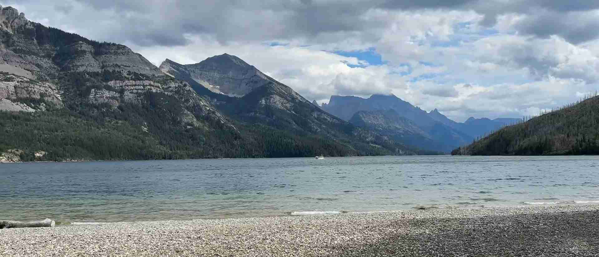
Waterton-Glacier International Peace Park UNESCO Guide: Cross-Border Natural Heritage
Waterton-Glacier International Peace Park unites two extraordinary mountain wilderness areas across the Canada-United States border, creating the world’s first International Peace Park in 1932 and earning UNESCO World Heritage designation in 1995. This transnational property protects 457,614 hectares of stunning Rocky Mountain landscapes where ancient geological forces, diverse ecosystems, and cross-border cooperation converge to preserve one of North America’s most biologically intact regions.
Key Takeaways
- World’s First International Peace Park: Waterton Lakes National Park (Alberta, Canada) and Glacier National Park (Montana, United States) joined in 1932 through grassroots Rotary Club initiative, inscribed as UNESCO World Heritage Site December 6, 1995 under natural criteria vii and ix.
- Exceptional Geological Significance: Features 1.5-billion-year-old Precambrian rock and the Lewis Overthrust fault where ancient rocks slid horizontally 100 kilometers over younger Cretaceous formations, creating one of Earth’s clearest examples of mountain-building through overthrusting.
- Tri-Ocean Hydrological Divide: Waters from the Continental Divide flow to three different oceans—Pacific, Atlantic, and Arctic—creating unique climatic conditions and ecological complexes found nowhere else on Earth.
- Extraordinary Biodiversity: Waterton Lakes National Park protects 60+ mammal species, 250+ bird species, and over 1,000 plant species within just 505 square kilometers, representing the highest biodiversity density of any Canadian Rocky Mountains park and containing rare species like grizzly bears, wolves, and cougars in intact habitat.
- Mountain-Prairie Interface: Unique transition zone where Rocky Mountain peaks rise abruptly from prairie grasslands creates exceptional ecological diversity with four distinct ecoregions supporting plant communities that exist nowhere else globally.
- Multiple International Designations: Beyond UNESCO World Heritage status, the park holds designations as Biosphere Reserve (1979), International Dark Sky Park (2017, certified 2021), and International Peace Park, reflecting its global significance for conservation, cooperation, and natural heritage protection.
People Also Ask About Waterton-Glacier International Peace Park
What Makes Waterton-Glacier the World’s First International Peace Park?
Waterton-Glacier International Peace Park earned its historic designation through grassroots diplomacy pioneered by Rotary Club members from Alberta and Montana. At a joint meeting at the Prince of Wales Hotel on July 4-5, 1931, Canadian and American Rotarians unanimously approved a resolution to unite Waterton Lakes National Park and Glacier National Park across the international border. The United States Congress passed legislation on December 8, 1931, followed by Canadian Parliament’s approval on May 26, 1932. The official dedication ceremony took place on June 18, 1932, at Glacier Park Lodge, establishing the world’s first International Peace Park as a symbol of peaceful cooperation between nations.
This designation demonstrated that international borders need not divide natural ecosystems or prevent collaborative conservation. The parks operate under separate national management systems but coordinate extensively on wildlife management, fire control, search and rescue operations, invasive species prevention, and scientific research through formal partnerships including the Crown Managers Partnership. The Peace Park concept pioneered at Waterton-Glacier has inspired similar transboundary protected areas worldwide, proving that environmental stewardship transcends political boundaries.
Why Did UNESCO Designate Waterton-Glacier as World Heritage?
UNESCO inscribed Waterton-Glacier International Peace Park on the World Heritage List on December 6, 1995, recognizing its outstanding universal value under two natural criteria. Criterion (vii) acknowledges the property’s superlative natural phenomena and exceptional natural beauty, including spectacular mountain scenery, glacial landforms, and abundant diversity of wildlife and wildflowers. The dramatic Rocky Mountain peaks, pristine alpine lakes, and striking geological formations create landscapes of exceptional aesthetic importance visible from both sides of the international border.
Criterion (ix) recognizes Waterton-Glacier as an outstanding example representing significant ongoing ecological and biological processes. The property occupies a pivotal position in the Western Cordillera of North America, resulting in the evolution of plant communities and ecological complexes that occur nowhere else in the world. Maritime weather systems from the Pacific Ocean reach the Continental Divide unimpeded by mountain ranges to the north and south, allowing plants and animals characteristic of the Pacific Northwest to extend eastward across the divide. This unique climatic setting, combined with the mountain-prairie interface and tri-ocean hydrographical divide, creates conditions supporting exceptional biodiversity and ongoing evolutionary processes.
What Is the Lewis Overthrust and Why Is It Geologically Important?
The Lewis Overthrust represents one of Earth’s most spectacular examples of mountain-building through overthrusting, where massive slabs of ancient rock moved horizontally across the landscape. This extraordinary geological formation features 1.5-billion-year-old Precambrian rocks that slid approximately 100 kilometers northeast over much younger Cretaceous rocks dating from 70 million years ago. The result defies typical geological sequences by placing ancient rocks atop substantially younger formations, creating a rare and dramatic demonstration of tectonic forces.
The Lewis Overthrust extends approximately 300 kilometers along the Rocky Mountain front from Bow Valley in Canada southward through Waterton-Glacier. Its clarity and accessibility make it one of the world’s best locations for studying overthrust mountain formation. Geologists can trace the thrust fault line across the landscape, particularly visible at Chief Mountain on the international border, where the contrast between the ancient Precambrian peaks and the younger prairie bedrock below creates striking visual evidence of the massive horizontal rock displacement. The overthrust also exposed six species of fossil stromatolites—ancient structures formed by cyanobacteria 1.3 billion years ago—providing rare insights into early life on Earth.
How Does the Tri-Ocean Hydrological Divide Work in Waterton-Glacier?
The Continental Divide passes directly through Waterton-Glacier International Peace Park, creating a unique tri-ocean hydrographical divide where precipitation falling on the park’s peaks flows toward three different oceans. Waters flowing westward enter the Columbia River system and reach the Pacific Ocean. Precipitation flowing eastward splits between two major drainage basins: the Mississippi River system carrying water to the Gulf of Mexico and Atlantic Ocean, and the Saskatchewan River system flowing to Hudson Bay and the Arctic Ocean. This rare triple-divide point creates exceptional climatic complexity within the park’s boundaries.
The tri-ocean divide produces distinctive microclimates and weather patterns that directly influence the park’s extraordinary biodiversity. Pacific maritime air masses reach the Continental Divide without significant mountain barriers to the west, bringing moisture and moderate temperatures that allow Pacific Northwest plant species to thrive on the eastern slopes—a phenomenon rare in the Rocky Mountains. Simultaneously, continental air masses from the prairies influence the eastern portions of the park. This convergence of different weather systems, combined with dramatic elevation changes from prairie grasslands at 1,290 meters to alpine peaks at 2,910 meters on Mount Blakiston, creates habitat diversity supporting over 1,000 plant species and contributing to the park’s status as one of the most ecologically complex protected areas in North America.
Extended multi-day tours – 5+ days
Featured Alberta Multi-Day Tour Packages

3 days
Alberta 3-Day Discovery Tour
- ✓ Comprehensive Alberta experience
- ✓ Expert local guides included
- ✓ All accommodation included
- ✓ Transportation provided

5 days
Alberta 5-Day Highlights Experience
- ✓ Comprehensive Alberta experience
- ✓ Expert local guides included
- ✓ All accommodation included
- ✓ Transportation provided

7 days
Alberta 7-Day Cultural Journey
- ✓ Comprehensive Alberta experience
- ✓ Expert local guides included
- ✓ All accommodation included
- ✓ Transportation provided

10 days
Alberta 10-Day Complete Adventure
- ✓ Comprehensive Alberta experience
- ✓ Expert local guides included
- ✓ All accommodation included
- ✓ Transportation provided
Multi-day tour packages powered by TourRadar. Prices and availability subject to change.
Introduction
The story of Waterton-Glacier International Peace Park embodies two powerful themes: the extraordinary natural forces that shaped one of Earth’s most geologically and ecologically significant landscapes, and the human capacity for peaceful cooperation across political boundaries in service of conservation. When Canadian and American citizens joined forces in 1932 to unite Waterton Lakes National Park and Glacier National Park, they created not merely a larger protected area but a radical new concept—that international borders need not prevent collaborative stewardship of shared natural heritage. This pioneering vision earned UNESCO World Heritage recognition in 1995, acknowledging both the area’s superlative natural values and its demonstration that environmental protection transcends national sovereignty.
Waterton-Glacier encompasses 457,614 hectares of rugged Rocky Mountain wilderness straddling the Canada-United States border in southern Alberta and northern Montana. The property’s two component parks—Waterton Lakes National Park (Canada) covering 50,500 hectares and Glacier National Park (United States) protecting 410,114 hectares—function as separate administrative units under their respective national park systems while coordinating extensively on conservation priorities, scientific research, and visitor management. This unique management structure reflects the Peace Park’s foundational principle: that ecological systems recognize no political boundaries and conservation success requires coordinated action across jurisdictional lines.
The landscape itself tells a dramatic geological narrative spanning 1.5 billion years. Ancient Precambrian rocks deposited as sediments at the bottom of a primordial sea were transformed by tectonic forces approximately 85 million years ago, then thrust horizontally over much younger formations in one of the planet’s most spectacular examples of overthrust faulting. The Lewis Overthrust moved massive rock slabs approximately 100 kilometers across the landscape, creating the dramatic mountain front visible today where ancient peaks rise abruptly from prairie grasslands. Subsequent glaciation carved the sharp peaks, U-shaped valleys, cirques, and pristine alpine lakes that characterize the park’s superlative scenery.
Beyond its geological significance, Waterton-Glacier protects one of the most ecologically intact and biodiverse temperate mountain ecosystems in North America. The property’s position at the convergence of three major climatic zones—Pacific maritime, Arctic continental, and prairie grassland—combined with its placement on the Continental Divide and dramatic elevation gradients creates habitat complexity supporting exceptional species diversity. Waterton Lakes National Park alone protects over 60 mammal species, 250 bird species, 24 fish species, and more than 1,000 plant species within its relatively compact 505 square kilometers, representing the highest biodiversity density of any Canadian Rocky Mountain national park.
The mountain-prairie interface proves particularly significant ecologically. Unlike most Rocky Mountain ranges that rise gradually from foothills, the mountains at Waterton ascend abruptly from prairie grasslands, creating a dramatic transition zone where species from both ecosystems intermingle. This interface supports unique plant communities adapted to the convergence of mountain and prairie climates, including over 175 provincially rare species and more than 50 nationally rare species. The area serves as critical habitat for large predators including grizzly bears, wolves, and cougars—species that have disappeared from most of their historic North American range but persist in the Waterton-Glacier ecosystem due to its size, habitat connectivity, and protected status.
Human history in the Waterton-Glacier region extends back at least 11,000 years, documented through 250 archaeological sites within Waterton Lakes National Park alone. Indigenous peoples including the Blackfoot Confederacy east of the Continental Divide and the Kutenai west of the divide utilized the area’s abundant resources for millennia, following seasonal migration patterns that took advantage of different elevation zones. The establishment of reserves and parks beginning in the late 19th century restricted traditional Indigenous access, though contemporary management increasingly recognizes and incorporates Indigenous knowledge and involvement in conservation decisions.
The Peace Park concept originated not from government initiative but from grassroots advocacy by Rotary Club members who recognized the ecological continuity across the international border. The 1932 designation demonstrated remarkable foresight, establishing a model for transboundary conservation that has since been replicated worldwide. The addition of UNESCO Biosphere Reserve status in 1979 and World Heritage inscription in 1995 reinforced international recognition of the property’s global significance for both natural heritage conservation and peaceful international cooperation.
Today, Waterton-Glacier faces contemporary conservation challenges including climate change impacts on glacial features and alpine ecosystems, invasive species threats, habitat fragmentation outside park boundaries, and increasing visitor pressure. The park’s glaciers have lost approximately 26.5 percent of their volume over recent decades, with continued retreat projected. Aquatic invasive species pose growing threats to native fish populations. Development pressures in the surrounding Crown of the Continent ecosystem create connectivity challenges for wide-ranging wildlife species. Addressing these issues requires the same spirit of international cooperation that created the Peace Park, now expanded to include multiple stakeholder partnerships, coordinated research programs, and adaptive management strategies designed to maintain the property’s Outstanding Universal Value for future generations.
Geological Formation and Features
Waterton-Glacier International Peace Park showcases one of Earth’s most dramatic geological narratives, where ancient seabeds became towering mountain peaks through extraordinary tectonic forces. The park’s rocks tell a story spanning 1.5 billion years, from the deposition of marine sediments in a primordial ocean to the catastrophic thrust faulting that built the Rocky Mountains and the subsequent glacial sculpting that created today’s landscape. This geological complexity makes Waterton-Glacier one of the world’s premier locations for understanding mountain-building processes and provides the foundation for the region’s exceptional biodiversity.
Precambrian Rock and Ancient Seabeds
The oldest rocks in Waterton-Glacier date from approximately 1.5 billion years ago during the Precambrian era, when shallow seas covered much of the North American continent. Marine sediments accumulated particle by particle on the seafloor over millions of years, eventually forming thick layers of limestone, dolomite, and what would become argillite—the distinctive red and green rocks visible throughout the park today. Evidence of this ancient marine environment persists in fossilized ripple marks preserved in rock faces, salt crystal casts that formed where seawater evaporated in shallow tidal zones, and stromatolites—layered structures created by colonies of cyanobacteria.
Stromatolites represent some of Earth’s earliest complex life forms, dating back 1.3 billion years in Waterton-Glacier. These dome-shaped structures formed when mats of photosynthetic cyanobacteria trapped sediment in shallow water, building up layer upon layer over centuries. The park contains six species of fossil stromatolites, providing rare windows into early biological processes during an era predating most familiar life forms. Living stromatolites exist in only a few locations globally today, primarily in Western Australia’s Shark Bay, making the fossil examples in Waterton-Glacier invaluable for understanding early Earth ecology and the evolution of photosynthesis.
The red and green argillite formations that give portions of the park their distinctive coloration—particularly visible at Red Rock Canyon—result from different oxidation states of iron within the rock. Red argillite contains oxidized iron, indicating exposure to oxygen-rich conditions during or after formation, while green argillite contains unoxidized iron, suggesting formation in oxygen-poor environments. These color variations create striking visual patterns in canyon walls and mountain faces, providing geologists with evidence about ancient environmental conditions when these sediments were deposited.
The Lewis Overthrust
The defining geological feature of Waterton-Glacier is the Lewis Overthrust, one of the world’s largest and most clearly visible examples of overthrust faulting. This extraordinary formation represents a fundamental departure from typical geological sequences where older rocks lie beneath younger layers. At Waterton-Glacier, 1.5-billion-year-old Precambrian rocks sit directly atop Cretaceous rocks dating from approximately 70 million years ago—a geological inversion that dramatically demonstrates the power of tectonic forces.
The overthrust occurred approximately 85 million years ago when tectonic plate movements generated immense horizontal pressure along the western edge of the North American continent. Rather than folding vertically like most mountain ranges, a massive slab of Precambrian rock—estimated at up to 5 kilometers thick—broke loose from its original position approximately 100 kilometers to the southwest and slid horizontally across the landscape as a relatively flat-lying thrust sheet. This single continuous movement contrasts with the multiple overlapping thrust sheets that characterize most of the Canadian Rockies, making the Lewis Overthrust particularly significant for understanding mountain-building mechanics.
The thrust fault line extends approximately 300 kilometers from Bow Valley in Canada southward through Waterton-Glacier, with the boundary between ancient overthrust rocks and younger underlying formations clearly visible at numerous locations. Chief Mountain, situated on the international border, provides perhaps the most dramatic visual demonstration of the overthrust. This isolated peak rises abruptly from surrounding prairie, its summit composed entirely of ancient Precambrian rock perched improbably atop the much younger Cretaceous bedrock visible at its base. The stark visual contrast between the massive ancient peak and the younger sediments below it allows even non-geologists to comprehend the scale of the geological displacement.
The accessibility and clarity of the Lewis Overthrust at Waterton-Glacier have made it one of the world’s most studied examples of thrust faulting. Early geological surveys in the late 19th and early 20th centuries recognized the area’s significance, with Captain Thomas Blakiston’s Palliser Expedition work in 1857-1860 and subsequent investigations by the Geological Survey of Canada establishing the fundamental structure. The proximity of the thrust line to the international border facilitated coordinated geological research by Canadian and American scientists, contributing significantly to understanding of overthrust mechanics and mountain-building processes globally.
Glacial Sculpting and Landforms
The dramatic topography visible at Waterton-Glacier today results largely from glacial processes that began approximately 1.9 million years ago and continued through multiple ice age cycles. During the Wisconsin glaciation—the most recent major glacial period ending approximately 11,000 years ago—massive ice sheets advanced and retreated across the landscape, carving the characteristic U-shaped valleys, sharp peaks, hanging valleys, and cirques that define the park’s mountain scenery. Although no glaciers remain in Waterton Lakes National Park today aside from small permanent snowfields, and Glacier National Park’s namesake features continue retreating rapidly, the landscape bears clear evidence of extensive past glaciation.
U-shaped valleys represent one of the most distinctive glacial landforms in the park. The Waterton Valley exemplifies this formation, where massive glaciers carved through solid rock, creating the characteristic wide, flat valley floor flanked by steep walls. Unlike the V-shaped valleys created by river erosion, glacially carved valleys have rounded bottoms and steep sides reflecting the bulldozing action of moving ice. Upper, Middle, and Lower Waterton Lakes occupy depressions scoured by glaciers at the base of steep-sided mountains, with Upper Waterton Lake reaching depths of 150 meters—one of the deepest lakes in the Canadian Rockies.
Hanging valleys appear throughout the park where tributary glaciers failed to erode as deeply as main valley glaciers, leaving valleys suspended high above the main valley floor. Water from these hanging valleys plunges dramatically as waterfalls, including Cameron Falls behind Waterton townsite, where Cameron Creek drops from a glacially carved hanging valley into the much deeper Waterton Valley. The falls have cut through layers of Precambrian rock, exposing the geological sequence and creating one of the park’s most accessible geological features.
Cirques—bowl-shaped depressions carved into mountain sides by glacial action—dot the high country throughout Waterton-Glacier. Cameron Lake occupies one such cirque at the terminus of the Akamina Parkway, where a moraine (the pile of rock and debris accumulated at a glacier’s terminus) dammed Cameron Creek after the glacier retreated, creating the lake. The steep headwalls surrounding Cameron Lake demonstrate the circular erosion pattern characteristic of cirque formation, where ice froze to the rock and plucked away material as the glacier moved.
Additional glacial features include kames and eskers—formations created by sediment deposition in and around melting glaciers. A prominent kame—a hill of sediment deposited by glacial meltwater—provides the elevated site for the iconic Prince of Wales Hotel overlooking Upper Waterton Lake. Eskers, sinuous ridges formed by sediment deposition in glacial meltwater streams, are visible in areas including the bison paddock. These landforms provide evidence of the complex processes occurring at glacier margins during the ice sheet’s final retreat approximately 11,000 years ago.
Ongoing Erosion and Contemporary Geological Processes
Geological forces continue shaping Waterton-Glacier’s landscape through ongoing erosion by water, wind, and ice. Mountain streams carry sediment from high elevations, gradually wearing down peaks while depositing material in valleys and lakes. Alluvial fans—spreading deposits of sediment at creek mouths—have formed where Blakiston Creek and Cameron River enter lakes, with the Waterton townsite situated on an alluvial fan created by Cameron Creek. Red Rock Canyon demonstrates active erosion as Cameron Creek continues cutting through layered argillite formations, exposing the distinctive red and green rocks and creating the narrow slot canyon visible today.
Freeze-thaw cycles contribute significantly to erosion in the alpine environment. Water seeping into rock cracks freezes during cold periods, expanding and gradually widening the fissures. Repeated freeze-thaw action over centuries breaks rocks apart, creating the talus slopes—accumulations of broken rock at cliff bases—visible throughout the high country. This mechanical weathering process gradually reduces mountain peaks while contributing to soil formation at lower elevations.
Climate change accelerates certain geological processes while potentially slowing others. Reduced snowpack and earlier spring melting alter erosion patterns and sediment transport in mountain streams. The retreat and disappearance of remaining glacial features in Glacier National Park represents a significant contemporary geological change, with implications for landscape evolution, ecosystem function, and the park’s namesake features. Monitoring these ongoing geological processes provides crucial data for understanding both natural mountain evolution and human-caused environmental changes.
Ecosystems and Biodiversity
Waterton-Glacier International Peace Park protects one of North America’s most intact and biodiverse temperate mountain ecosystems. The property’s exceptional species richness results from its unique position at the convergence of multiple climatic zones, its dramatic elevation gradients from prairie to alpine environments, and the mountain-prairie interface that creates habitat complexity found nowhere else. The Canadian portion alone—Waterton Lakes National Park’s 505 square kilometers—supports biodiversity density unmatched by any other Canadian Rocky Mountain park, making conservation of this relatively small area disproportionately important for regional and continental biodiversity.
Four Distinct Ecoregions
Waterton Lakes National Park encompasses four distinct ecoregions reflecting dramatic elevation changes from prairie grasslands to alpine peaks. The Foothills Parkland ecoregion occupies approximately 10 percent of the park on its eastern side, where Rocky Mountains meet prairie. This transition zone features rough fescue grasslands interspersed with aspen groves, creating habitat for species adapted to both mountain and prairie environments. The semiarid vegetation in this zone includes native grasses that once covered vast stretches of the Great Plains, now rare due to agricultural conversion and development outside protected areas.
The Montane ecoregion extends from valley floors to approximately 1,500 meters elevation, characterized by a mixture of dry grasslands and open forests of lodgepole pine, Douglas fir, and aspen. This zone supports the highest wildlife diversity in the park due to its moderate climate, abundant food sources, and vegetation diversity. Stream valleys within the montane zone feature wetlands and riparian woodlands providing critical habitat for amphibians, waterfowl, and species requiring water access. The lower portion of the Bertha Lake Trail traverses classic montane forest, offering accessible experience of this ecoregion’s high canopy and wildflower-covered forest floor.
The Subalpine ecoregion covers approximately 35 percent of the park’s area, extending from roughly 1,500 to 2,200 meters elevation. Subalpine forests of Engelmann spruce, subalpine fir, whitebark pine, and larch dominate this zone, with trees becoming progressively shorter and more widely spaced as elevation increases toward treeline. Cameron Lake area contains mature subalpine forests with trees up to 400 years old, representing the park’s oldest growth forests that have survived fire and insect outbreaks through centuries. The Carthew Lakes Trail provides excellent access to subalpine environments, passing through distinct forest types as elevation changes.
The Alpine ecoregion occupies the highest elevations above treeline, where harsh conditions including extreme cold, high winds, short growing seasons, and intense solar radiation limit vegetation to low-growing plants adapted to severe environments. Alpine meadows burst with wildflowers during the brief summer growing season, supporting specialized plant communities found nowhere else. Rocky outcrops provide habitat for mountain goats and bighorn sheep, while alpine birds including ptarmigans inhabit the high country. The alpine zone’s fragile ecosystems prove particularly vulnerable to climate change and visitor impact, requiring careful management to maintain ecological integrity.
Exceptional Plant Diversity
Over 1,000 plant species have been recorded within Waterton Lakes National Park—representing more than half of all plant species in Alberta within just 505 square kilometers. This extraordinary botanical diversity results from the park’s unique geographic position where maritime weather systems from the Pacific Ocean reach the Continental Divide, the mountain-prairie interface creating multiple transition zones, and elevation gradients providing diverse habitat conditions within compact geography. The park supports 175 provincially rare species, over 50 nationally rare species, and 23 species found only in the Waterton area globally.
Beargrass (Xerophyllum tenax) ranks among Waterton’s most distinctive wildflowers, with large fluffy white flower heads atop tall green stalks creating striking displays across mountain meadows. This species typically grows only west of the Continental Divide, but Pacific maritime air masses reaching Waterton allow beargrass to thrive east of the divide in what represents its easternmost natural range. The flowers bloom in multi-year cycles with particularly spectacular displays occurring periodically, drawing photographers and wildflower enthusiasts from across North America.
Fireweed (Chamaenerion angustifolium) carpets disturbed areas with brilliant pink blooms, thriving particularly in areas affected by the 2017 Kenow Wildfire that burned through portions of the park. This pioneer species colonizes burned areas rapidly, stabilizing soils while providing nectar for pollinators. The extensive fireweed blooms following the wildfire demonstrate natural succession processes and ecosystem resilience, transforming burned landscapes into vibrant displays of color.
Glacier lilies (Erythronium grandiflorum) emerge as the snow melts in spring, often pushing through remaining snow patches to bloom in alpine and subalpine meadows. These yellow flowers signal spring’s arrival in the mountains and provide critical early-season nectar for emerging insects and hummingbirds. Other notable wildflowers include bright yellow arnica, colorful Indian paintbrush in shades from red to orange to yellow, and rare orchids occupying specialized niches throughout the park.
The park’s botanical significance extends beyond wildflowers to include diverse moss, lichen, and fern communities that contribute to ecosystem function and provide habitat structure for invertebrates and small mammals. Old-growth forests contain rare lichen species sensitive to air quality and climate conditions, serving as indicators of ecosystem health. Wetland areas support specialized aquatic and semi-aquatic plant communities including sedges, rushes, and aquatic flowering plants critical for waterfowl and amphibian habitat.
Mammal Diversity and Large Predators
Waterton-Glacier protects over 60 mammal species in the Canadian portion alone, representing one of the most intact large mammal communities in the lower 48 United States and southern Canada. The property’s size, habitat diversity, and protected status enable it to support populations of large predators including grizzly bears, black bears, wolves, cougars, wolverines, and lynx—species that have disappeared from most of their historic North American ranges. Maintaining these predator populations requires extensive habitat and prey availability, making Waterton-Glacier’s role in regional conservation increasingly critical as development fragments habitat outside park boundaries.
Grizzly bears (Ursus arctos horribilis) represent one of the park’s most iconic and conservation-significant species. These massive omnivores range throughout the park from valley bottoms to alpine zones, feeding on vegetation including berries, roots, and grasses as well as opportunistic meat sources including carrion, ground squirrels, and occasionally ungulate calves. Grizzlies require enormous home ranges—up to several hundred square kilometers for adult males—making habitat connectivity essential for population viability. The Crown of the Continent ecosystem including Waterton-Glacier represents one of the few remaining strongholds for grizzly bears in the contiguous United States.
Black bears (Ursus americanus) are more numerous than grizzlies and adapt more readily to human presence, though they still require substantial habitat and tend to avoid developed areas. Black bears inhabit forested areas throughout the park, particularly visible in berry patches during late summer when they intensively feed to build fat reserves for winter hibernation. Both bear species enter dens in late autumn and emerge in spring, with females giving birth to cubs in winter dens. Bear safety protocols require all hikers to carry bear spray, make noise while traveling, and properly store food and garbage to avoid habituating bears to human food sources.
Wolves (Canis lupus) historically roamed throughout the region but were extirpated from much of their range during the 20th century through predator control programs. Wolves have reestablished presence in Waterton-Glacier, though sightings remain relatively rare due to their elusive nature and low population density. Wolves primarily prey on elk, deer, and moose, playing crucial ecosystem roles by regulating ungulate populations and creating carrion for scavengers. The presence of wolves in Waterton-Glacier contributes to trophic cascade effects where predation influences prey behavior, vegetation patterns, and overall ecosystem function.
Cougars (Puma concolor), also called mountain lions, represent the park’s largest cat species and most elusive large predator. These solitary hunters primarily prey on deer, with individual cougars maintaining large territories. Cougar sightings occur infrequently due to their secretive nature and primarily nocturnal hunting behavior. Other wild cat species in the park include lynx (Lynx canadensis) and bobcats (Lynx rufus), both of which prey primarily on snowshoe hares and smaller mammals.
Ungulate species provide essential prey for large predators while playing their own ecosystem roles through vegetation browsing and serving as prey. Elk (Cervus canadensis), the largest and most visible ungulates in the park, congregate in large herds particularly visible in the Blakiston Fan area south of the entrance parkway. Hundreds of elk often gather in this area where they can be observed from vehicles. Mule deer (Odocoileus hemionus) and white-tailed deer (Odocoileus virginianus) occupy different habitats, with mule deer preferring open forests and white-tailed deer favoring riparian thickets. Both species commonly enter Waterton townsite where they become habituated to human presence.
Moose (Alces alces), North America’s largest deer species, inhabit wetlands and willow thickets along streams and lakes, particularly visible along the Akamina Parkway. These massive animals browse on aquatic vegetation and willow shoots, requiring access to water and riparian habitat. Bighorn sheep (Ovis canadensis) frequent rocky cliffs and open slopes at higher elevations, with their excellent climbing ability providing escape from predators. Mountain goats (Oreamnos americanus) inhabit the highest, steepest terrain including alpine cliffs where their specialized hooves provide secure footing on precipitous slopes.
The park also supports a managed bison (Bison bison) herd in a dedicated paddock area, providing opportunities for visitors to observe these iconic prairie mammals that once ranged across the Great Plains in massive herds. Smaller mammals including river otters, beavers, marmots, pikas, snowshoe hares, and numerous rodent species fill diverse ecological niches throughout the park’s ecosystems.
Bird Diversity and Migratory Significance
Over 250 bird species have been recorded in Waterton Lakes National Park, making it one of the premier birding destinations in the Canadian Rockies. The park’s position at the intersection of two major avian migratory routes—the Central and Pacific flyways—creates exceptional bird diversity, particularly during spring and fall migration periods when thousands of waterfowl stage in the park’s lakes and wetlands. The convergence of multiple habitat types from prairie grasslands to alpine tundra supports specialized bird communities adapted to each environment.
Waterfowl including various duck species, Canada geese, tundra swans, and trumpeter swans utilize the park’s lakes and wetlands heavily during migration. Maskinonge Lake and Lower Waterton Lake prove particularly important staging areas where migratory waterfowl rest and feed before continuing their journeys. Golden eagles, bald eagles, and various hawk species hunt over open areas and along lake margins, with golden eagles frequently visible soaring over mountain ridges during autumn migration.
Forest bird communities include Clark’s nutcrackers, Steller’s jays, Canada jays (formerly gray jays), and mountain bluebirds occupying different forest zones. Red-tailed hawks hunt in open areas while ravens and crows scavenge throughout the park. Alpine birds including white-tailed ptarmigans inhabit high-elevation areas above treeline, their plumage changing seasonally from mottled brown in summer to pure white in winter for camouflage in different conditions. The park’s diverse bird communities provide essential ecosystem services including seed dispersal, insect control, and carrion cleanup while serving as indicators of ecosystem health.
Aquatic Ecosystems and Fish Diversity
Waterton Lakes and the park’s numerous streams support 24 fish species including several species of conservation concern. Bull trout (Salvelinus confluentus), cutthroat trout (Oncorhynchus clarkii), and rainbow trout (Oncorhynchus mykiss) represent native species facing threats from habitat degradation and competition from introduced species. The cold, clear waters required by native trout species make them particularly sensitive to climate change impacts including warming water temperatures and altered flow regimes.
Upper Waterton Lake’s unusual feature of crossing the international border creates interesting jurisdictional questions for aquatic management. The lake’s depth and cold temperatures support unique aquatic communities including populations of kokanee salmon and lake trout. Cameron Lake provides habitat for introduced trout populations popular with recreational anglers while raising conservation concerns about impacts on native aquatic species.
Aquatic invasive species represent a growing threat to native fish and aquatic invertebrate communities. Zebra mussels, quagga mussels, and other invasive species could devastate native ecosystems if introduced to park waters. Both Waterton and Glacier have implemented strict regulations prohibiting motorized watercraft on certain lakes to reduce invasion risk, with watercraft inspection programs operating at park entrances. Protecting native aquatic species requires ongoing monitoring, strict biosecurity measures, and adaptive management as new invasive species threats emerge.
The Mountain-Prairie Interface
Waterton-Glacier’s most distinctive ecological feature is the dramatic mountain-prairie interface where Rocky Mountain peaks rise abruptly from prairie grasslands with minimal intervening foothills. This unusual topographic configuration creates ecological conditions found nowhere else on Earth, contributing directly to the property’s UNESCO World Heritage inscription. The interface zone supports unique plant communities, provides critical wildlife habitat, and demonstrates ongoing ecological processes that earned recognition under criterion (ix) of the World Heritage Convention.
Ecological Significance of the Interface
Unlike most Rocky Mountain ranges that rise gradually through foothills zones allowing species to sort themselves along gradual elevation gradients, Waterton’s mountains ascend directly from prairie with minimal transitional habitat. This compression creates concentrated biodiversity where prairie-adapted and mountain-adapted species intermingle within compact geography. Species from both ecosystems extend their ranges into the interface zone, with prairie plants climbing onto lower mountain slopes and mountain species descending to prairie edges, creating novel species assemblages characteristic only of this region.
The interface supports the highest density of wildlife in the park, with ungulates including elk, deer, and moose using prairie areas for grazing while retreating to forested mountain slopes for cover. Large predators hunt the interface zone where prey species concentrate. Grizzly bears feed extensively on prairie plant species including biscuitroot and springbeauty in spring before moving to higher elevations as summer progresses. This elevational migration pattern depends on the availability of resources across the mountain-prairie gradient.
Wind patterns characteristic of the interface contribute to unique climatic conditions. Chinook winds—warm, dry winds descending from mountain peaks—moderate winter temperatures on the prairie side of the park, creating some of Alberta’s warmest winter conditions. These periodic warm spells allow some wildlife species to remain active year-round rather than entering full hibernation. However, chinooks also create rapid temperature fluctuations and can increase fire risk during dry periods.
Climate Patterns and Pacific Maritime Influence
The mountain-prairie interface at Waterton-Glacier creates exceptional climatic complexity by combining continental prairie conditions with mountain weather patterns and Pacific maritime influence. Unlike most Rocky Mountain locations east of the Continental Divide, Waterton receives significant influence from Pacific air masses that reach the divide without major mountain barriers to the west. This maritime influence brings moisture and moderate temperatures that allow Pacific Northwest plant species to extend unusually far east, creating plant communities found nowhere else.
The convergence of Arctic continental, Pacific maritime, and prairie climatic systems creates highly variable weather patterns. Summers prove relatively brief, cool, and rainy with frequent thunderstorms. Winters bring heavy snowfall averaging 481.5 centimeters annually at Waterton townsite, though chinook winds periodically raise temperatures above freezing even in midwinter. This climatic variability requires species to adapt to unpredictable conditions, favoring generalists and species with broad environmental tolerances.
The tri-ocean hydrographical divide running through the park contributes to climatic complexity by positioning Waterton-Glacier at a fundamental geographic dividing point for North American weather patterns. Precipitation falling on park peaks flows toward three different oceans, reflecting the convergence of different air masses and drainage systems. This unique hydrological position combines with elevation gradients from 1,290 meters at the townsite to 2,910 meters on Mount Blakiston to create numerous microclimates supporting specialized plant communities within compact geography.
UNESCO World Heritage Designation
Waterton-Glacier International Peace Park’s inscription on the UNESCO World Heritage List represents recognition of both its superlative natural values and its pioneering demonstration of transboundary conservation cooperation. The property’s path to World Heritage status involved decades of scientific research, conservation advocacy, and international coordination, culminating in inscription on December 6, 1995. This designation places Waterton-Glacier among fewer than 250 natural World Heritage properties globally, acknowledging its outstanding universal value to all humanity.
Inscription Process and Criteria
Both component parks of the Peace Park held significant conservation designations before their joint World Heritage nomination. Waterton Lakes National Park and Glacier National Park were each designated UNESCO Biosphere Reserves in 1979, recognizing their value for conservation research and sustainable development demonstration. This Biosphere Reserve status established international recognition of the properties’ conservation significance and provided foundation for subsequent World Heritage consideration. The transition from separate Biosphere Reserve designations to joint World Heritage nomination required coordination between Canadian and American authorities and demonstrated the benefits of unified conservation approaches for transboundary ecosystems.
The World Heritage nomination process began with recognition that the properties met multiple natural criteria for outstanding universal value. An initial nomination of Glacier National Park alone was deferred in 1985, with UNESCO recommending a transnational proposal that would recognize the ecological unity of the entire Peace Park. This deferral proved pivotal, requiring both nations to collaborate on a joint nomination that emphasized the properties’ shared ecological values rather than treating them as separate national parks that happened to share a border.
The successful nomination demonstrated that Waterton-Glacier meets two of the natural criteria required for World Heritage inscription. Criterion (vii)—containing superlative natural phenomena or areas of exceptional natural beauty and aesthetic importance—recognizes the property’s spectacular mountain scenery featuring dramatic peaks, pristine lakes, glacially carved valleys, and exceptional landscape beauty appreciated by visitors from both sides of the border. The property’s visual impact results from the combination of ancient rock formations thrust dramatically upward, subsequent glacial sculpting creating sharp peaks and U-shaped valleys, and the striking contrast between mountain wilderness and prairie grasslands at the mountain-prairie interface.
Criterion (ix)—representing outstanding examples of significant ongoing ecological and biological processes—acknowledges Waterton-Glacier’s exceptional importance for understanding evolution and ecosystem function. The property’s position at the convergence of multiple climatic zones, its placement on the Continental Divide with tri-ocean hydrographical drainage, and the mountain-prairie interface create conditions supporting plant communities and ecological complexes that exist nowhere else. Pacific maritime influence reaching across the Continental Divide allows Pacific Northwest species to extend into the heart of the Rocky Mountains, creating unique biodiversity patterns. The property also represents one of the last intact predator-prey systems in temperate North America, with full complements of large carnivores including grizzly bears, wolves, and cougars coexisting with diverse prey species in functional ecosystems.
Outstanding Universal Value Statement
The UNESCO World Heritage Committee’s Statement of Outstanding Universal Value synthesizes why Waterton-Glacier merits global protection and recognition. The statement emphasizes the property’s exceptional natural beauty manifested in its superlative mountain scenery, pristine lakes, and dramatic geological formations. The Lewis Overthrust represents one of Earth’s clearest examples of overthrust mountain building, where 1.5-billion-year-old rocks moved horizontally approximately 100 kilometers to rest atop rocks 70 million years old—a geological phenomenon visible and comprehensible even to non-specialists due to dramatic exposures at locations including Chief Mountain.
The Outstanding Universal Value statement also highlights Waterton-Glacier’s significance for biodiversity conservation and ongoing ecological processes. The property occupies a pivotal biogeographic position in the Western Cordillera of North America where different ecological regions intersect, creating exceptional species richness within compact geography. Over 1,000 plant species in Waterton Lakes National Park’s 505 square kilometers represents extraordinary density of botanical diversity. The property supports one of North America’s most intact large mammal communities including full predator guilds, demonstrating ecosystem functionality increasingly rare in developed regions.
The designation recognizes that Waterton-Glacier’s Outstanding Universal Value depends on maintaining ecological integrity across the international border. Grizzly bears, wolves, and other wide-ranging species require habitat extending beyond individual park boundaries, making coordinated transboundary management essential for conservation success. The World Heritage designation reinforces obligations for both nations to protect the property’s values through cooperative management, coordinated research, and unified conservation strategies.
International Cooperation and Management
Waterton-Glacier’s World Heritage status builds on and reinforces the collaborative management framework established when the parks united as an International Peace Park in 1932. The two component parks remain separate administrative units managed under their respective national park systems—Waterton by Parks Canada under Canadian federal legislation, and Glacier by the U.S. National Park Service under American federal law. This dual management structure reflects different national approaches to protected area governance while requiring extensive coordination to address shared conservation priorities.
Management plans for both parks incorporate common principles regarding natural and cultural resource protection, visitor use management, scientific research, and relations with Indigenous peoples. These shared principles emerge from ongoing coordination between park management teams who meet regularly to address transboundary issues including wildlife management, wildfire response, search and rescue operations, invasive species control, and visitor management. The Crown Managers Partnership, established in 2001, provides a broader forum for coordinating conservation across the Crown of the Continent ecosystem including Waterton-Glacier and surrounding protected areas in British Columbia, Alberta, Montana, and on Indigenous lands.
Scientific research coordination represents a crucial component of transboundary management. Wildlife studies tracking grizzly bears, wolves, and other mobile species require data collection on both sides of the border to understand population dynamics and habitat needs. Climate change research monitoring glacier retreat, plant community shifts, and ecosystem responses to warming temperatures benefits from coordinated data collection using comparable methodologies. Aquatic invasive species prevention requires unified inspection programs and coordinated responses to threats affecting both parks.
The World Heritage designation brings additional international attention and accountability to conservation management. UNESCO periodic reporting requirements compel both nations to document conservation status, threats, and management effectiveness at regular intervals. This reporting process enables early identification of emerging threats while demonstrating management successes. If the World Heritage Committee identifies significant threats to Outstanding Universal Value, it can place properties on the List of World Heritage in Danger, creating international pressure for remedial action. While Waterton-Glacier has never faced danger listing, the mechanism provides additional safeguards beyond national protected area legislation.
Indigenous Peoples and Cultural Heritage
Human presence in the Waterton-Glacier region extends back at least 11,000 years, documented through 250 archaeological sites within Waterton Lakes National Park alone. Indigenous peoples utilized the region’s abundant resources seasonally, following patterns that took advantage of different elevation zones as plant foods ripened and wildlife migrations occurred. The establishment of parks and reserves beginning in the late 19th century displaced Indigenous communities from traditional territories and restricted access to important cultural sites and resources. Contemporary management increasingly recognizes Indigenous knowledge and involves Indigenous communities in conservation decisions, though tensions persist between conservation mandates and Indigenous rights.
Traditional Use and Archaeological Evidence
The earliest human inhabitants entered the region as glaciers retreated approximately 11,000 years ago, following megafauna including mammoths and ancient bison across newly exposed landscapes. Archaeological evidence from this Paleoindian period includes distinctive spear points and tool assemblages associated with big game hunting. As megafauna disappeared and climate warmed, inhabitants adapted to changing environmental conditions, developing more diverse subsistence strategies incorporating plant gathering, fishing, and hunting of modern bison, elk, and deer species.
Between 10,000 and 1,600 years before present, regional populations diversified into two primary cultural patterns. Groups east of the Continental Divide focused heavily on bison hunting on the plains, developing specialized techniques including driving bison herds over cliffs at jump sites such as Head-Smashed-In Buffalo Jump south of Waterton. Groups west of the divide practiced more diversified hunting, fishing, and gathering economies adapted to mountain and river valley environments. These different subsistence patterns shaped distinct cultural practices, social organization, and material culture visible in archaeological assemblages.
By approximately 1,600 years ago, the region’s Indigenous inhabitants had organized into identifiable tribal groups that persisted into the historical period. The Blackfoot Confederacy—including the Piikani (Peigan), Kainai (Blood), Siksika (Blackfoot), and allied groups—dominated the plains east of the Continental Divide including the Waterton area. The Kutenai people occupied territories west of the divide including mountain valleys and river systems draining toward the Pacific. The Continental Divide represented a cultural as well as geographical boundary, with different linguistic groups and cultural practices on opposite sides.
European Contact and Displacement
European-American expansion into the region accelerated during the mid-19th century, bringing fundamental disruptions to Indigenous lifeways. The fur trade introduced new economic systems and trade goods while depleting wildlife populations including beaver. Introduced diseases including smallpox devastated Indigenous populations that lacked immunity. The decline of bison herds through overhunting and habitat loss undermined Plains groups’ primary subsistence base. By the 1880s, the once-vast bison herds that sustained Plains Indigenous peoples had been hunted nearly to extinction, forcing cultural adaptations and increasing dependence on government support.
Treaty negotiations and reserve establishment formalized Indigenous dispossession from traditional territories. The Blackfoot Confederacy signed Treaty 7 with the Canadian government in 1877, ceding vast territories including the Waterton area in exchange for reserves, annuities, and promised government support. The Blackfeet Nation in Montana ceded portions of their territory that would become Glacier National Park through an 1895 agreement with the U.S. government. These transactions occurred under duress as Indigenous groups faced starvation following bison extirpation and had limited negotiating power. The 1895 agreement guaranteed certain Blackfeet rights in the ceded territory, though these rights have been disputed and restricted over subsequent decades.
The establishment of Waterton Lakes Forest Reserve in 1895 and its designation as a national park in 1911 occurred without meaningful Indigenous consultation or consent. Park regulations prohibited traditional activities including hunting, plant gathering, and ceremonial use of sites within park boundaries. Indigenous people could enter the parks as visitors but faced restrictions on traditional practices central to cultural continuity. This pattern of conservation through Indigenous exclusion characterized national park establishment throughout North America, reflecting prevailing assumptions that wilderness required human absence and that Indigenous resource use threatened conservation goals.
Contemporary Indigenous Relations and Management Participation
Contemporary park management in both Canada and the United States increasingly recognizes Indigenous connections to park lands and seeks to involve Indigenous communities in conservation decisions. Parks Canada’s mandate explicitly includes working with Indigenous peoples to protect cultural resources and incorporate traditional knowledge into management. The U.S. National Park Service similarly emphasizes tribal consultation and collaboration. Both Waterton Lakes and Glacier National Parks maintain formal relationships with Indigenous communities including the Blackfoot Confederacy and Blackfeet Nation.
Traditional knowledge contributes to understanding of ecosystem function, wildlife behavior, and plant community dynamics. Indigenous knowledge holders possess detailed understanding of seasonal patterns, wildlife movements, and ecological relationships developed through millennia of careful observation. Incorporating this knowledge into scientific research and management planning enriches understanding while acknowledging Indigenous intellectual contributions. Joint research projects involving Indigenous knowledge holders and Western scientists increasingly characterize conservation research in the Crown of the Continent ecosystem.
Cultural site protection represents an important component of Indigenous collaboration. Archaeological sites within the parks document millennia of human occupation and provide tangible links to ancestral territories for contemporary Indigenous communities. Medicine wheels, vision quest sites, rock art locations, and other cultural features require protection from disturbance while remaining accessible for appropriate ceremonial use. Park regulations increasingly accommodate Indigenous ceremonial access while protecting sites from vandalism and unauthorized visitation.
Tensions persist between conservation mandates and Indigenous rights, particularly regarding hunting, plant gathering, and other traditional practices prohibited by park regulations. Some Indigenous advocates argue for restoration of treaty-guaranteed rights to hunt and gather within park boundaries, pointing to successful co-management models implemented at other protected areas. Park managers face challenges balancing mandates to protect wildlife and ecosystems from all consumptive use while acknowledging Indigenous rights and cultural needs that predate park establishment. Addressing these tensions requires ongoing dialogue, creative management solutions, and willingness to challenge assumptions about wilderness and conservation that emerged from cultural contexts very different from Indigenous perspectives.
Visitor Experience and Access
Waterton Lakes National Park welcomes over 400,000 visitors annually, offering exceptional opportunities for experiencing mountain wilderness, wildlife observation, and outdoor recreation within compact, accessible geography. The park’s relatively small size compared to other Canadian Rocky Mountain parks means visitors can access diverse ecosystems and spectacular scenery without extensive travel between destinations. The Waterton townsite provides visitor services including accommodations, restaurants, and interpretive facilities, while an extensive trail network provides access to backcountry wilderness.
The Waterton Townsite
Waterton townsite serves as the park’s primary visitor service hub, situated on an alluvial fan at the northern end of Upper Waterton Lake where Cameron Creek enters the lake. The townsite’s dramatic setting—surrounded by mountains rising directly from the lakeshore—provides immediate immersion in mountain scenery. The iconic Prince of Wales Hotel, perched on a prominent hilltop overlooking Upper Waterton Lake, represents one of the most photographed structures in the Canadian Rockies. This historic hotel, completed in 1927, demonstrates Swiss-inspired architecture characteristic of early national park tourism development.
The townsite remains relatively uncommercial compared to larger Rocky Mountain resort communities, maintaining a village character focused on park access rather than extensive commercial development. Visitor facilities include the Parks Canada Visitor Centre providing information, interpretive displays, and trip planning assistance; multiple accommodation options from campgrounds to hotels; restaurants and cafes; and essential services including groceries and outdoor equipment supplies. The compact townsite design allows visitors to walk between facilities while observing wildlife including deer and bighorn sheep that frequently enter developed areas.
Cameron Falls, located immediately behind the townsite, provides easily accessible waterfall viewing where Cameron Creek plunges from a hanging valley over layered Precambrian rock. Interpretive displays explain the geological formation and glacial processes that created the falls and the valley below. The falls demonstrate active erosion as water continues cutting through ancient rock formations, creating a visible connection between geological past and ongoing landscape evolution.
Scenic Drives and Accessible Viewpoints
Two scenic parkways provide vehicle access to diverse park environments. The Akamina Parkway extends approximately 16 kilometers from the townsite to Cameron Lake, climbing through montane and subalpine forest zones while offering viewpoints overlooking valleys and mountain peaks. The parkway terminates at Cameron Lake, where a short walking trail circles the lakeshore and longer hiking trails depart for backcountry destinations. The lake’s cirque setting with steep mountain walls rising directly from the water demonstrates classic glacial landforms, while its position straddling the international border creates the unusual situation of a single lake shared between two countries.
The Red Rock Parkway extends approximately 15 kilometers from the townsite to Red Rock Canyon, passing through prairie grasslands, aspen groves, and montane forest. The Blakiston Fan area along the parkway often hosts hundreds of elk, providing exceptional wildlife viewing opportunities from vehicles. Red Rock Canyon, the parkway’s terminus, features a short interpretive trail through a narrow slot canyon where Red Rock Creek has eroded through layers of colorful argillite. The distinctive red and green rocks result from different oxidation states of iron, creating striking visual patterns best appreciated during afternoon light.
Entrance Parkway connecting Highway 5 to the townsite traverses the mountain-prairie interface zone, demonstrating the dramatic transition from prairie grasslands to mountain peaks. Multiple pullouts provide viewpoints overlooking Middle and Lower Waterton Lakes and the surrounding mountains. The Bison Paddock along the entrance parkway allows visitors to observe free-roaming bison descended from the massive herds that once dominated the Great Plains.
Hiking Trails and Backcountry Access
Waterton Lakes National Park maintains approximately 200 kilometers of hiking trails ranging from short interpretive walks to multi-day backcountry routes. This extensive trail network provides access to diverse ecosystems, wildlife habitat, geological features, and remote wilderness areas. Trail difficulty varies dramatically, with several wheelchair-accessible interpretive trails near the townsite and extremely challenging routes requiring significant fitness, route-finding skills, and wilderness experience.
Bear’s Hump Trail represents one of the park’s most popular short hikes, climbing steeply 1.4 kilometers from behind the Visitor Centre to a rocky promontory offering panoramic views over Upper Waterton Lake, the townsite, the Prince of Wales Hotel, and surrounding mountains extending into Glacier National Park. The trail gains 225 meters elevation, providing a vigorous workout rewarded by exceptional scenery accessible within an hour or two round trip. The viewpoint’s position demonstrates the glacial kame landform created by sediment deposition in melting ice.
Bertha Lake Trail extends 11.4 kilometers round trip from the townsite to Bertha Lake, passing through montane forest, crossing avalanche paths, and reaching a subalpine lake nestled beneath steep mountain walls. Bertha Falls, approximately midway along the trail, provides an optional shorter destination. The trail demonstrates elevation-related ecosystem changes as vegetation transitions from valley-bottom forests through increasingly subalpine conditions approaching the lake.
Crypt Lake Trail ranks among Canada’s most spectacular and challenging day hikes, requiring a boat shuttle across Upper Waterton Lake to the trailhead. The 17.3-kilometer round trip includes 680 meters elevation gain, four waterfall crossings, a natural tunnel requiring headlamp navigation, a metal ladder ascending a cliff face, and an exposed traverse along a narrow ledge with chain handholds. The destination—Crypt Lake—sits in a dramatic cirque surrounded by vertical cliffs, with the trail briefly crossing into Montana before returning to Canada. The combination of sustained physical challenge, technical sections requiring sure footing, and spectacular scenery makes Crypt Lake one of the park’s signature experiences for adventurous hikers.
Carthew-Anderson Trail provides an outstanding point-to-point route covering 20.1 kilometers from Cameron Lake to the townsite with 650 meters elevation gain to Carthew Summit before descending through changing ecosystems. The high route traverses alpine and subalpine environments with expansive views across peaks extending into Glacier National Park, demonstrating the ecological connectivity across the international border. A commercial shuttle service operates from the townsite to Cameron Lake, allowing hikers to begin at the higher elevation trailhead and finish in town rather than requiring two vehicles.
Backcountry camping opportunities exist at designated campgrounds throughout the park’s trail system, requiring advance reservations and backcountry camping permits. Multi-day routes allow extended wilderness immersion while distributing visitor use to minimize ecological impacts. Backcountry travel requires thorough preparation including bear awareness training, navigation skills, appropriate equipment, and understanding of Leave No Trace principles to minimize environmental impacts.
Wildlife Viewing Protocols and Safety
Wildlife observation represents a primary visitor experience in Waterton-Glacier, with frequent opportunities to observe large mammals including bears, elk, deer, bighorn sheep, and occasionally wolves or cougars. Responsible wildlife viewing requires maintaining safe distances, never approaching or feeding animals, and carrying bear spray on all trails. Parks Canada regulations prohibit approaching wildlife, with specific minimum distance requirements depending on species. These regulations protect both visitor safety and animal welfare by preventing habituation, stress responses, and potentially dangerous encounters.
Bear safety protocols prove essential for all trail users in Waterton-Glacier’s intact predator-prey ecosystem. All hikers must carry bear spray—a capsaicin-based deterrent proven effective at stopping aggressive bears—in immediately accessible holsters rather than buried in packs. Making noise while hiking alerts bears to human presence, allowing them to leave the area and avoiding surprise encounters that trigger defensive behaviors. Traveling in groups of four or more significantly reduces bear encounter risks. Proper food storage in bear-proof containers or by hanging food away from camping areas prevents bears from obtaining human food rewards that drive habituation and food-conditioned behaviors leading to human-bear conflicts.
The park implements area closures and trail restrictions periodically to protect wildlife during sensitive periods including denning, calving, and intensive feeding seasons. These closures balance visitor access with conservation needs, recognizing that some areas and times require prioritizing wildlife over recreation. Respecting closures and restrictions demonstrates commitment to maintaining the ecological values that justify the park’s existence and UNESCO designation. Visitors can check current closure information at the Visitor Centre, on the Parks Canada website, or by calling park dispatch at 1-888-927-3367.
Conservation Challenges and Management
Waterton-Glacier International Peace Park faces numerous contemporary conservation challenges requiring adaptive management, international cooperation, and sustained commitment to maintaining the property’s Outstanding Universal Value. Climate change, invasive species, habitat connectivity, wildfire management, and increasing visitor pressure create complex interconnected challenges that transcend park boundaries and require coordinated responses across jurisdictions. Addressing these challenges effectively determines whether the property can maintain its ecological integrity and continue providing ecosystem services, biodiversity protection, and visitor experiences that justify its World Heritage status.
Climate Change Impacts
Climate change represents the most pervasive and potentially transformative threat to Waterton-Glacier’s ecosystems. The property has already experienced measurable changes including glacier retreat, altered precipitation patterns, earlier spring snowmelt, and shifts in plant and animal distributions. The glaciers in Glacier National Park—the park’s namesake features—have lost approximately 26.5 percent of their volume over recent decades, with projections suggesting complete disappearance of remaining glaciers within decades if warming continues. Waterton Lakes National Park contains no significant glaciers currently, though permanent snowfields persist in protected high-elevation locations.
Glacier retreat produces cascading ecological effects extending far beyond loss of ice features. Glacial meltwater contributes to summer stream flows, maintaining cold water temperatures critical for native trout and other aquatic species. As glaciers disappear, late-summer stream flows decline and water temperatures rise, potentially exceeding thermal tolerances for cold-adapted species. Alpine and subalpine plant communities shift upslope tracking suitable climate conditions, but species already at elevation limits face potential extirpation with nowhere higher to migrate. High-elevation specialists including pikas, ptarmigans, and alpine-adapted plants prove particularly vulnerable to warming-driven range contractions.
Warming temperatures alter wildlife behavior patterns, phenology, and species interactions. Earlier spring snowmelt triggers earlier plant emergence, potentially creating mismatches between wildlife reproduction timing and peak food availability. Bear denning patterns may shift, with warmer autumns delaying den entry and warmer springs triggering earlier emergence. Insect outbreaks including mountain pine beetle increase in frequency and intensity with warmer temperatures, potentially causing widespread tree mortality that restructures forest ecosystems. These complex cascading effects challenge management responses because addressing symptoms without controlling underlying warming proves ultimately futile.
Management responses to climate change include monitoring ecosystem changes to detect early warning signals, protecting climate refugia where local conditions may buffer against regional warming, maintaining habitat connectivity to facilitate species range shifts, and engaging in collaborative research to understand climate impacts and potential adaptation strategies. The Crown Managers Partnership facilitates coordinated climate change research and management across the Crown of the Continent ecosystem, recognizing that effective responses require landscape-scale coordination transcending individual park boundaries.
Invasive Species Threats
Non-native invasive species pose severe threats to Waterton-Glacier’s native biodiversity and ecosystem function. Aquatic invasive species including zebra mussels, quagga mussels, and New Zealand mud snails could devastate native aquatic communities if introduced to park waters. These invaders reproduce rapidly, lack natural predators in North American waters, and can fundamentally alter aquatic food webs while competing with native species. Preventing aquatic invasive introductions requires strict biosecurity protocols including watercraft inspection programs, prohibition of motorized boats on vulnerable lakes, and educational campaigns informing visitors about cleaning boats and equipment between water bodies.
Terrestrial plant invaders including spotted knapweed, leafy spurge, houndstongue, and Canada thistle colonize disturbed areas along trails, roads, and in developed areas, outcompeting native plants and reducing habitat quality for wildlife. The 2017 Kenow Wildfire increased invasive plant vulnerability by creating extensive disturbed areas where invasive species can establish before native plants recover. Controlling terrestrial invasives requires sustained effort including manual removal, targeted herbicide application, revegetation with native species, and “PlayCleanGo” protocols where visitors clean equipment between destinations to avoid transporting seeds.
White-nose syndrome, a fungal disease devastating bat populations across North America, threatens Waterton-Glacier’s bat species. This invasive pathogen spreads rapidly through bat hibernacula, causing mortality rates exceeding 90 percent in affected populations. Protecting bats requires monitoring for disease arrival, implementing decontamination protocols for spelunkers and researchers, and potentially closing sensitive bat habitat if infection appears. The disease’s severity demonstrates how invasive pathogens can decimate native species with limited management options once establishment occurs.
Habitat Connectivity and Surrounding Landscape Management
Wide-ranging species including grizzly bears, wolves, and wolverines require habitat extending far beyond Waterton-Glacier’s boundaries. Genetic exchange between populations depends on maintaining connectivity corridors allowing individuals to move between protected core areas. Development, highways, and resource extraction activities outside park boundaries can fragment habitat, isolating populations and reducing genetic diversity. Maintaining connectivity proves essential for long-term population viability, particularly as climate change drives species range shifts requiring movement across landscapes.
The Crown of the Continent ecosystem encompasses roughly 44,000 square kilometers of public and private lands surrounding Waterton-Glacier, including national forests, provincial forests, wilderness areas, tribal lands, and private properties. Coordinated conservation across this broader landscape requires cooperation among federal, state, provincial, tribal, and private landowners. The Crown Managers Partnership facilitates this coordination, bringing together land managers from different jurisdictions and ownership categories to address shared conservation priorities including wildlife corridors, fire management, invasive species control, and recreation impacts.
Resource extraction activities including logging, mining, and energy development on lands adjacent to park boundaries create potential impacts on park ecosystems. Noise, habitat disturbance, pollution, and increased human access associated with extraction activities can affect wildlife behavior, water quality, and ecological integrity within parks. While park boundaries provide legal protection from resource extraction within designated areas, they cannot prevent external activities from generating impacts that cross boundaries. Addressing these issues requires strong environmental regulation of activities near parks and ongoing dialogue between conservation agencies and resource industries.
Fire Management
Wildfire represents both a natural ecological process essential for ecosystem function and a management challenge requiring careful balancing of ecological needs, human safety, and infrastructure protection. Historical fire suppression policies disrupted natural fire regimes, allowing fuel accumulation that increases intensity of fires when ignition occurs. The 2017 Kenow Wildfire burned approximately 19,300 hectares in Waterton Lakes National Park—nearly 40 percent of the park’s area—demonstrating the power of fires burning through accumulated fuels under extreme weather conditions.
Contemporary fire management recognizes fire’s ecological role while protecting human life and infrastructure. Prescribed burning under controlled conditions reduces fuel loads while restoring natural fire regimes. Fire-adapted species including lodgepole pine and fireweed thrive after burns, regenerating forests and creating early successional habitat valuable for wildlife. However, climate change increases fire risk through warmer temperatures, earlier snowmelt creating longer fire seasons, and potential increases in lightning ignition frequency. Adapting fire management to changing conditions requires flexibility, improved fire behavior modeling, and coordination across the international border.
The 2017 Kenow Wildfire demonstrated both fire’s destructive power and ecosystem resilience. While the fire consumed vast areas of forest and forced evacuation of the townsite, post-fire recovery has proceeded rapidly with vigorous regeneration of fire-adapted species. Fireweed carpets burned areas with brilliant pink blooms, aspen suckers sprout prolifically from root systems protected underground, and lodgepole pine seedlings establish in newly exposed mineral soil. Wildlife populations adapt to changed habitat conditions, with some species avoiding burned areas while others take advantage of early successional vegetation. Monitoring post-fire recovery provides valuable data on ecosystem resilience and recovery trajectories under contemporary climate conditions.
Visitor Management and Recreation Impacts
Over 400,000 annual visitors to Waterton Lakes National Park create management challenges balancing public access with ecosystem protection. Popular trails experience heavy use concentrating impacts along narrow corridors, with soil erosion, vegetation trampling, and wildlife displacement occurring at heavily used locations. The park’s compact size means a relatively small area absorbs substantial visitor pressure, intensifying per-hectare impacts compared to larger parks where use distributes across more extensive geography.
Trail maintenance requirements increase with heavy use, necessitating infrastructure including bridges, boardwalks, and hardened tread surfaces to prevent erosion and contain use within designated corridors. Backcountry camping generates impacts at designated campgrounds where repeated use prevents vegetation recovery. Human waste disposal, food residue, and noise affect local wildlife behavior patterns, potentially excluding sensitive species from otherwise suitable habitat near popular use areas. Managing these impacts requires strategic trail design routing use away from sensitive areas, campground hardening and periodic resting, and visitor education emphasizing Leave No Trace principles.
Visitor safety management proves essential in wilderness areas harboring large predators and featuring rugged terrain with objective hazards including avalanches, rockfall, and extreme weather. All trail users must carry bear spray and understand proper response procedures for bear encounters. Parks Canada provides mandatory backcountry orientation for overnight visitors, covering bear safety, navigation, Leave No Trace camping practices, and emergency protocols. Search and rescue operations occur regularly, requiring coordinated response capabilities and public education about trip planning, hazard recognition, and knowing personal limitations.
The International Dark Sky Park designation recognizes exceptional night sky quality while creating obligations to minimize light pollution. The townsite employs dark-sky-friendly lighting fixtures that minimize upward light scatter, allowing visitors to experience naturally dark night skies increasingly rare in developed regions. This designation creates opportunities for astronomy programs and night sky appreciation while demonstrating that conservation extends beyond daytime ecosystems to encompass the full 24-hour environmental experience.
The Crown of the Continent Ecosystem
Waterton-Glacier International Peace Park forms the protected core of the larger Crown of the Continent ecosystem, a roughly 44,000-square-kilometer region spanning the Canada-United States border from Crowsnest Pass in British Columbia south through northwestern Montana. This broader ecosystem encompasses numerous protected areas including national parks, national forests, provincial parks, wilderness areas, and Indigenous reserves, along with private lands including working ranches and timberlands. Understanding Waterton-Glacier’s conservation significance requires recognizing its role within this larger landscape where ecological processes, wildlife populations, and hydrological systems function at scales transcending individual protected areas.
Ecosystem Scale and Connectivity
The Crown of the Continent represents one of North America’s most ecologically intact temperate mountain ecosystems, retaining full complements of native species including large predators and supporting ecological processes largely eliminated from more developed regions. The ecosystem’s name derives from its position along the Continental Divide where waters flow toward three oceans, creating a “crown” of mountain peaks from which rivers descend in all directions. This hydrological significance combines with exceptional biodiversity, geological diversity, and relatively intact habitat to create global conservation importance.
Wildlife populations within the Crown of the Continent operate at ecosystem scales requiring habitat connectivity across jurisdictions and ownership categories. Grizzly bears range across hundreds of square kilometers during their lifetimes, crossing international borders, moving between public and private lands, and utilizing different seasonal habitats as food availability changes. Wolves establish territories encompassing diverse land ownerships, requiring prey populations and secure denning sites distributed across the landscape. Maintaining viable populations of these wide-ranging species depends on preserving connectivity between protected core areas, allowing individual movement, genetic exchange, and recolonization of temporarily vacant habitats.
The Crown Managers Partnership facilitates ecosystem-scale coordination by bringing together land managers from Canadian federal, provincial, and Indigenous authorities; U.S. federal and state agencies; tribal governments; and non-governmental conservation organizations. This partnership addresses shared challenges including wildlife corridor protection, fire management coordination, invasive species control, and recreation impact management. The collaborative approach recognizes that effective conservation requires transcending jurisdictional boundaries to address ecological realities operating at landscape scales.
Protected Area Network
Multiple protected areas within the Crown of the Continent create a conservation network with Waterton-Glacier at its core. On the Canadian side, Waterton Lakes National Park connects northward to Castle Provincial Park and Castle Wildland Provincial Park, recently established protected areas extending conservation protection further into important wildlife habitat. To the west, Akamina-Kishinena Provincial Park and the Flathead River valley provide connectivity toward British Columbia’s protected areas. On the U.S. side, Glacier National Park borders Bob Marshall Wilderness Complex—a vast roadless area encompassing multiple designated wilderness areas totaling over 600,000 hectares—extending protected habitat southward.
This protected area network creates large continuous blocks of conservation land reducing habitat fragmentation and providing secure core areas for sensitive species. Wilderness areas within the network prohibit motorized access, resource extraction, and permanent infrastructure, maintaining particularly high levels of ecological integrity. The combination of national parks’ comprehensive protection, wilderness areas’ prohibitions on mechanized use, and various provincial parks’ conservation designations creates a mosaic of protected lands collectively securing the Crown of the Continent’s ecological values.
Gaps in the protected area network occur where private lands, resource extraction activities, or development interrupt connectivity between protected cores. The Flathead River valley in British Columbia, directly adjacent to both Waterton-Glacier and the Bob Marshall Wilderness, faced coal mining proposals that would have fragmented critical wildlife corridors and degraded water quality in rivers flowing into protected areas. Conservation advocacy and ultimately provincial government decisions prevented large-scale mining development, maintaining the valley’s conservation values. This example demonstrates ongoing tensions between development pressures and conservation goals in unprotected portions of the ecosystem.
Indigenous Territories and Traditional Lands
The Crown of the Continent encompasses traditional territories of multiple Indigenous peoples including the Blackfoot Confederacy, Blackfeet Nation, Kutenai Nation, and others whose ancestral lands extend across the ecosystem. Contemporary reserves and reservations occupy portions of traditional territories, with treaty rights sometimes extending to Crown lands including protected areas. Recognizing Indigenous connections to the ecosystem and involving Indigenous communities in conservation planning represents both an ethical imperative and practical necessity for achieving conservation goals.
Indigenous traditional knowledge contributes significantly to understanding ecosystem function, wildlife behavior, and plant ecology. Knowledge holders possess detailed understanding of seasonal patterns, species relationships, and landscape changes developed through millennia of close observation and transmission across generations. Incorporating traditional knowledge into conservation science enriches understanding while acknowledging Indigenous intellectual contributions. Collaborative research projects involving Indigenous knowledge holders and Western scientists increasingly characterize ecosystem-scale conservation planning in the Crown of the Continent.
Some Indigenous communities advocate for co-management arrangements granting formal decision-making authority over traditional territories including protected areas. The Kainai Nation in Alberta and the Blackfeet Nation in Montana maintain particularly strong connections to Waterton-Glacier, with ongoing efforts to increase Indigenous involvement in management decisions. Successful co-management models from other regions demonstrate potential benefits including improved conservation outcomes through incorporation of traditional ecological knowledge, enhanced cultural site protection, and strengthened Indigenous rights recognition.
Research and Scientific Significance
Waterton-Glacier International Peace Park serves as an outdoor laboratory for scientific research addressing fundamental questions in ecology, evolution, geology, climate science, and conservation biology. The property’s diverse ecosystems, intact species communities, long-term protection status, and accessibility for researchers have generated extensive scientific literature contributing to understanding of mountain ecosystems globally. Ongoing research programs monitor ecosystem changes, test conservation strategies, and provide data informing management decisions for Waterton-Glacier and similar protected areas worldwide.
Long-term Ecological Monitoring
Long-term monitoring programs track ecosystem changes over decades, providing baseline data essential for detecting trends, understanding natural variability, and distinguishing human-caused changes from natural fluctuations. Glacier National Park maintains one of North America’s longest continuous ecological monitoring programs, with some datasets extending back to the early 20th century. Waterton Lakes National Park’s monitoring programs, while more recent, contribute valuable Canadian perspective on transboundary ecosystem processes.
Climate monitoring stations throughout the parks record temperature, precipitation, snowpack, and other meteorological variables, documenting warming trends and altered precipitation patterns. Repeat photography comparing historical and contemporary images of glaciers quantifies ice loss and demonstrates landscape changes visible to non-specialists. Phenology monitoring tracks timing of plant flowering, leaf emergence, and autumn senescence, documenting shifts toward earlier spring events and later autumn transitions consistent with warming temperatures.
Wildlife population monitoring employs diverse methodologies including aerial surveys for ungulates, camera trapping for elusive carnivores, genetic sampling for population structure analysis, and radio telemetry tracking individual animal movements. These programs reveal population trends, habitat selection patterns, and movement corridors essential for conservation planning. Grizzly bear research in the Crown of the Continent has produced seminal contributions to understanding bear ecology, habitat requirements, and human-bear conflict mitigation strategies applied globally.
Climate Change Research
The U.S. Geological Survey’s Northern Rocky Mountain Science Center, based in Bozeman, Montana, coordinates extensive climate change research in Glacier National Park examining ecosystem responses to warming. Research topics include glacier retreat rates and projections, alpine plant community shifts, treeline advance into previously tundra areas, and altered hydrological regimes. This research provides early warning of changes likely to affect other mountain regions as warming continues, making Waterton-Glacier a sentinel site for understanding climate impacts on mountain ecosystems.
Glacier retreat monitoring employs satellite imagery, aerial photography, ground surveys, and historical comparisons to document ice loss and project future trajectories. These studies reveal that named glaciers have decreased from approximately 150 when the park was established in 1910 to fewer than 30 active glaciers today, with many of the remaining features projected to disappear within decades. The research documents not only ice loss but also cascading effects on aquatic ecosystems, vegetation patterns, and landscape evolution.
Research on alpine ecosystem responses to warming examines how plant species shift distributions, how altered snowmelt timing affects plant phenology, and how warming interacts with other stressors including invasive species and altered disturbance regimes. These studies reveal complex non-linear responses where multiple stressors interact, producing outcomes difficult to predict from single-factor experiments. The findings inform adaptive management strategies while contributing to global understanding of climate change impacts on mountain biodiversity.
Transboundary Wildlife Research
Grizzly bear research conducted collaboratively across the international border has produced groundbreaking insights into bear ecology, population dynamics, and conservation requirements. Radio-collar studies tracking individual bears demonstrate extensive cross-border movements, with bears utilizing habitat in both countries without regard for political boundaries. Genetic analysis reveals population structure and connectivity, identifying critical linkage zones where maintaining habitat quality proves essential for genetic exchange. DNA sampling from hair snares provides non-invasive population estimates and monitors genetic diversity over time.
Wolf research following recolonization of Glacier National Park and dispersal into Waterton examines pack formation, territory establishment, predation patterns, and ecosystem effects. Studies comparing areas with and without wolf presence demonstrate trophic cascade effects where wolf predation on elk influences elk behavior, vegetation browsing patterns, and riparian vegetation recovery. This research contributed to understanding of predator restoration ecology and top-down regulation of ecosystems, with applications extending far beyond Waterton-Glacier.
Ungulate research tracks population trends, habitat use, migration patterns, and disease dynamics for elk, deer, moose, bighorn sheep, and mountain goats. Seasonal migration studies reveal elevation-based movements as ungulates track vegetation green-up in spring and descend to lower elevations in winter. These patterns demonstrate the importance of elevational diversity within protected areas and connectivity to seasonal ranges outside park boundaries. Disease monitoring including chronic wasting disease surveillance provides early warning of emerging wildlife health threats.
Aquatic Ecosystem Research
Research on native fish populations including bull trout, cutthroat trout, and rare fish species examines factors limiting population viability and tests restoration strategies. Studies document negative impacts from introduced non-native fish species that compete with or prey on native species. Removal programs targeting non-native species in select streams demonstrate that native fish populations can recover when competition and predation pressure decreases. These restoration efforts provide models for recovering imperiled native fish populations in other mountain regions.
Water quality monitoring tracks nutrients, sediments, temperature, and chemical parameters in streams and lakes, establishing baselines and detecting changes over time. Research examining glacier retreat impacts on stream hydrology documents declining late-summer flows and warming water temperatures as glacial meltwater contributions decrease. These hydrological changes have profound implications for aquatic species adapted to cold, stable water conditions, potentially forcing distributional shifts or local extirpations as suitable habitat disappears.
Aquatic invasive species research focuses on prevention, early detection, and potential response strategies if invasive species establish despite prevention efforts. Studies model invasion pathways, evaluate inspection program effectiveness, and test rapid response protocols. This research proves critically important given that successful aquatic invasive establishment could irreversibly alter native aquatic communities with limited remediation options once invasions establish.
International Dark Sky Park Designation
Waterton-Glacier International Peace Park achieved International Dark Sky Park certification in 2017, becoming the world’s first transboundary Dark Sky Park and the first International Dark Sky designation crossing an international border. Full certification was achieved in 2021, recognizing exceptional night sky quality, comprehensive lighting management policies, and strong public outreach promoting dark sky awareness and light pollution reduction. This designation complements the park’s UNESCO World Heritage and Biosphere Reserve status, demonstrating that comprehensive conservation extends beyond terrestrial and aquatic ecosystems to encompass the complete environmental experience including naturally dark night skies.
Night Sky Quality and Astronomical Significance
The Crown of the Continent region’s remoteness from major urban centers, high elevation, and typically clear skies create exceptional conditions for night sky viewing and astronomical observation. On clear moonless nights, the Milky Way appears prominently from horizon to horizon, thousands of individual stars become visible, and meteor showers display dramatically. This naturally dark sky quality represents increasingly rare conditions as light pollution from urban development spreads across landscapes, making protected areas among the few remaining locations where people can experience primordial night sky conditions.
Astronomical features visible from Waterton-Glacier include the Milky Way’s core visible during summer months, the Andromeda Galaxy visible to naked eye observation under optimal conditions, satellites passing overhead including the International Space Station during visible passes, and spectacular meteor shower displays during annual events including the Perseids in August and Geminids in December. The dark sky designation creates opportunities for astronomy education programs connecting park visitors with celestial phenomena many have never experienced due to urban light pollution.
Scientific research benefits from dark sky conditions, with astronomical monitoring programs tracking satellite populations, space debris, and light pollution trends. Measurements of sky brightness at standardized locations document baseline conditions and detect changes over time. These data contribute to continental-scale mapping of light pollution spread and inform policies addressing outdoor lighting design to minimize upward light scatter.
Light Pollution Management
Achieving and maintaining Dark Sky Park certification requires comprehensive outdoor lighting management minimizing light pollution while maintaining public safety. The Waterton townsite implemented dark-sky-friendly lighting featuring full cutoff fixtures that direct light downward rather than allowing upward scatter, shielding preventing direct view of bright light sources, and appropriate light levels providing necessary visibility without excessive brightness. These lighting improvements demonstrate that effective outdoor lighting need not produce light pollution, providing models for other communities.
Park facilities including visitor centers, campgrounds, and roadways utilize similar dark-sky-friendly lighting principles. Motion-sensor lights activate only when needed rather than remaining lit continuously, reducing energy consumption while minimizing wildlife disturbance. Pathway lighting employs low-level illumination sufficient for safe navigation without overwhelming night vision adaptation. These lighting strategies balance safety requirements with conservation goals including protecting nocturnal wildlife and preserving night sky quality.
Light pollution management extends beyond park boundaries to include coordination with surrounding communities and developments. The Waterton Biosphere Reserve provides a framework for engaging private landowners, businesses, and municipalities in adopting lighting best practices. While parks can control lighting within their boundaries, maintaining dark sky conditions requires broader landscape-scale cooperation preventing external light pollution from degrading park night sky quality. This collaborative approach demonstrates the interconnectedness of conservation issues requiring coordination across jurisdictions and ownership categories.
Nocturnal Ecology and Wildlife Protection
Natural darkness provides essential conditions for nocturnal wildlife including owls, bats, nocturnal mammals, and insects requiring darkness for hunting, navigation, and reproduction. Artificial light disrupts these species’ behaviors and can exclude them from otherwise suitable habitat near light sources. Maintaining naturally dark conditions at night protects nocturnal ecosystem function while preserving the complete daily cycle of environmental conditions to which species have adapted over evolutionary time.
Research on light pollution impacts on wildlife reveals complex effects including altered predator-prey interactions when artificial light advantages visual predators, disrupted insect reproduction when light interferes with mating behaviors, and navigational confusion for migrating birds using celestial cues. Some species adapt to artificial lighting by shifting activity patterns or avoiding lit areas, while others prove unable to adjust, resulting in population declines in light-polluted areas. Protecting naturally dark conditions at Waterton-Glacier preserves habitat for light-sensitive species while providing reference conditions for understanding light pollution impacts elsewhere.
Dark sky protection also benefits human health and well-being through maintaining natural circadian rhythm cues and providing psychological benefits from experiencing naturally dark night skies. Many visitors from urban areas express profound reactions to experiencing truly dark skies for the first time, describing feelings of connection to natural cycles and cosmic perspective impossible to achieve under light-polluted skies. These experiential values complement ecological and astronomical rationales for dark sky protection, demonstrating multiple benefits from comprehensive conservation approaches.
Frequently Asked Questions
How Do I Visit Both the Canadian and American Sides of the Peace Park?
Visiting both Waterton Lakes National Park in Canada and Glacier National Park in the United States requires crossing the international border through designated entry points. The Chief Mountain border crossing, connecting Alberta Highway 6 from the Canadian side to Montana Highway 17 from the American side, provides the only road crossing within the Peace Park boundaries. This seasonal crossing operates approximately May through September, with exact dates varying annually based on weather and operational considerations. During the Chief Mountain crossing’s closed season, the year-round Carway/Piegan crossing north of the parks provides the nearest alternative border entry point.
Visitors must carry proper identification for international border crossing including passports or enhanced driver’s licenses meeting WHTI (Western Hemisphere Travel Initiative) requirements. Border crossing procedures include declaration of goods, immigration inspection, and potential vehicle search. Processing times vary depending on traffic volume and security situations, with longer waits possible during peak summer weekends and holidays. Current border crossing requirements and wait times can be checked through official border services websites before travel.
The parks maintain separate entrance fee systems despite their joint designation as an International Peace Park. Waterton Lakes National Park entrance fees are collected by Parks Canada, while Glacier National Park entrance fees are collected by the U.S. National Park Service. Annual passes and reciprocal pass agreements may not apply across the border, requiring separate payment for each park. The parks operate under different regulations reflecting their respective national park systems, including different rules regarding pets, backcountry permits, firearms, and commercial activities. Visitors should review regulations for both parks before crossing to ensure compliance with all applicable rules.
What Is the Best Time to Visit Waterton Lakes National Park?
Waterton Lakes National Park remains open year-round, though visitor facilities, services, and trail access vary dramatically by season. The peak visitor season spans July and August when all facilities operate, all trails are accessible, wildflowers bloom prolifically, and weather proves most reliable for outdoor activities. Over half the park’s annual visitors arrive during these two months, creating crowded conditions on popular trails and in the townsite. Temperatures during peak season typically range from daily highs of 20-25°C (68-77°F) to nighttime lows of 5-10°C (41-50°F), with frequent afternoon thunderstorms providing dramatic weather displays and temporary trail closures due to lightning risk.
June and September offer excellent shoulder season conditions with fewer visitors, lower accommodation costs, and still-accessible trail systems. June brings snowmelt-swollen waterfalls, emerging wildflowers at lower elevations, and energetic wildlife including bears feeding intensively after winter hibernation. However, high-elevation trails may remain snow-covered into late June, requiring route-finding skills and avalanche awareness in some areas. September delivers spectacular autumn colors as aspen and larch turn golden yellow, with generally stable weather before autumn storms arrive. Wildlife activity intensifies during September as animals prepare for winter, including elk rutting season when male elk bugle to attract mates and compete for breeding dominance.
May and October represent transitional periods with reduced visitor services, unpredictable weather including potential significant snowfall, and limited trail accessibility at higher elevations. These months appeal to visitors seeking solitude and willing to accept weather uncertainty. Spring wildlife viewing proves exceptional as bears emerge from dens and ungulates descend to lower elevations following snowmelt. Autumn brings waterfowl migrations staging in park lakes, with thousands of migrating birds providing exceptional birding opportunities.
Winter transforms Waterton into a snow-covered wilderness with minimal facilities and services. The townsite maintains limited winter operations including a few accommodations, the Visitor Centre with reduced hours, and basic services. Most park roads close to vehicles, becoming routes for cross-country skiing and snowshoeing. The Red Rock Parkway becomes a popular winter trail system accessible only on foot, skis, or snowshoes. Winter conditions require appropriate equipment, clothing, and avalanche awareness for backcountry travel. However, chinook winds periodically bring dramatic warm spells creating some of Alberta’s most moderate winter conditions, occasionally raising temperatures above freezing even in January.
Can I Hike Between Waterton and Glacier National Parks?
Several hiking trails cross the international border between Waterton Lakes National Park and Glacier National Park, providing unique opportunities to walk between countries while experiencing backcountry wilderness. However, crossing the international border on foot requires compliance with customs and immigration procedures similar to road crossing, with specific requirements depending on which trail and crossing direction. The most accessible transboundary hiking experience occurs on the Crypt Lake Trail, which briefly enters Montana before returning to Alberta, though this represents a short loop rather than a point-to-point border crossing.
The Waterton Valley Trail extends from Waterton townsite south along the west shore of Upper Waterton Lake, crossing into Montana and continuing through Glacier National Park’s backcountry to Goat Haunt ranger station. This approximately 13-kilometer route provides the most straightforward transboundary hiking option, though it requires proper border crossing procedures. The International Ferry connecting Waterton townsite to Goat Haunt ranger station provides return transportation during summer operating season, though ferry service depends on seasonal operations and can be disrupted by weather or mechanical issues. Hikers crossing into the United States must report to Goat Haunt ranger station for customs processing, requiring proper identification and declaration procedures.
Crossing into Canada from Glacier National Park requires reporting to Canadian border officials either at a staffed crossing or through remote reporting procedures established for specific backcountry crossings. Waterton Park Dispatch (1-888-927-3367) provides current information on border crossing procedures for backcountry trails. Failure to properly report border crossings can result in significant penalties including fines and potential criminal charges, making compliance essential regardless of wilderness setting.
Backcountry camping near the border requires permits from the appropriate park authority—Parks Canada permits for Canadian backcountry, National Park Service permits for American backcountry. Coordinating permits for multi-day trips crossing between parks requires advance planning and clear understanding of permit requirements for both jurisdictions. Some trails including Boundary Creek and Kishinena routes cross into British Columbia’s provincial parks, adding additional jurisdictional complexity requiring separate permits and regulation compliance.
What Indigenous Peoples Are Connected to Waterton-Glacier?
Multiple Indigenous nations maintain deep ancestral and contemporary connections to the Waterton-Glacier region, with traditional territories encompassing the Peace Park and surrounding Crown of the Continent ecosystem. The Blackfoot Confederacy—consisting of the Piikani (Peigan), Kainai (Blood), and Siksika (Blackfoot) nations in Canada, along with the allied Blackfeet Nation in Montana—held territories east of the Continental Divide including the Waterton area and much of the Great Plains. The Blackfoot people developed sophisticated cultures adapted to prairie and mountain environments, following seasonal patterns that utilized different elevation zones as resources became available throughout the year.
The Kutenai (also spelled Kootenai or Ktunaxa) people occupied territories west of the Continental Divide including valleys draining toward the Pacific Ocean. The Continental Divide represented not only a hydrological boundary but also a cultural and linguistic divide between Blackfoot and Kutenai territories. Trade, warfare, and complex diplomatic relationships connected these groups despite territorial boundaries and linguistic differences. Both groups utilized the high country along the divide for seasonal hunting, plant gathering, and spiritual purposes, with archaeological evidence documenting presence extending back thousands of years.
Contemporary descendants of these Indigenous nations maintain cultural, spiritual, and familial connections to the Waterton-Glacier region despite displacement to reserves and reservations during the 19th and early 20th centuries. The establishment of parks and subsequent regulations prohibiting hunting, plant gathering, and other traditional activities severed many practical connections to ancestral territories while leaving cultural and spiritual relationships intact. Blackfoot place names, oral histories, and traditional ecological knowledge reflect millennia of intimate familiarity with the landscape and its resources.
Modern relationships between Indigenous communities and park management have evolved toward greater recognition of Indigenous rights and increased involvement in conservation decisions. Formal consultation processes engage Indigenous communities in management planning, cultural site protection, and traditional knowledge documentation. Some Indigenous advocates call for co-management arrangements granting formal decision-making authority, pointing to successful models from other regions where co-management has improved conservation outcomes while strengthening Indigenous rights recognition. The potential for enhanced Indigenous involvement in Waterton-Glacier management remains an active discussion area with implications for conservation practice, Indigenous self-determination, and relationship between Indigenous peoples and settler society institutions.
How Does the 2017 Kenow Wildfire Continue to Affect the Park?
The Kenow Wildfire ignited on September 11, 2017, burning approximately 19,300 hectares—nearly 40 percent of Waterton Lakes National Park’s total area—before being declared controlled in November 2017. The fire burned with extreme intensity through areas of dense forest where decades of fire suppression had allowed fuel accumulation, creating crown fires that killed most trees and consumed organic soil layers. The fire forced complete evacuation of Waterton townsite, destroyed or damaged numerous structures including the historic visitor reception centre and several homes, and fundamentally altered large portions of the park’s landscape.
Post-fire recovery demonstrates remarkable ecosystem resilience as fire-adapted species regenerate vigorously across burned areas. Fireweed (Chamaenerion angustifolium) colonized burned areas rapidly, carpeting the landscape with vibrant pink blooms during summer months and stabilizing soils while providing nectar for pollinators. Aspen trees regenerate through root suckers, sprouting prolifically from surviving root systems to create dense young aspen groves. Lodgepole pine seedlings establish in exposed mineral soils, with serotinous cones (cones that remain closed until exposed to fire’s heat) releasing seeds after the fire to regenerate pine forests. These natural regeneration processes demonstrate that fire, while catastrophic from human perspectives, represents a natural ecological process to which native species are well adapted.
Wildlife responses to the Kenow Fire vary by species and habitat requirements. Some species avoid recently burned areas due to reduced cover and altered food availability, while others take advantage of early successional vegetation and increased visibility for hunting. Elk and deer browse on regenerating vegetation, woodpeckers feed on insects colonizing dead trees, and cavity-nesting birds utilize standing dead snags. Long-term wildlife monitoring tracks population responses to changed habitat conditions, providing data on recovery trajectories and species-specific habitat associations.
Infrastructure recovery proceeded alongside ecological regeneration. Parks Canada rebuilt damaged facilities including a new visitor centre that opened in 2021, incorporating modern design and interpretive displays explaining fire ecology and the Kenow Fire’s impacts. Trails through burned areas reopened progressively as hazard trees were removed and tread surfaces stabilized. Some trails remain subject to periodic closures when high winds threaten to topple standing dead trees, requiring ongoing hazard assessment and risk management.
The fire increased vulnerability to invasive plant species by creating extensive disturbed areas where invasive species can establish before native plants recover. Parks Canada implemented aggressive invasive species monitoring and control programs in burned areas, manually removing invasive plants and revegetating with native species to reduce invasion opportunities. This adaptive management approach demonstrates learning from the fire while working to maintain native plant community integrity during recovery.
The Kenow Fire also provides valuable research opportunities examining fire effects on ecosystems, recovery trajectories under contemporary climate conditions, and the effectiveness of post-fire management interventions. Permanent monitoring plots established across severity gradients from low-intensity surface fires to stand-replacing crown fires document vegetation recovery rates, wildlife habitat development, and soil recovery processes. These data contribute to understanding of fire ecology and inform management strategies for future fires anticipated with increasing frequency and intensity under climate change scenarios.
What Are the Main Differences Between Canadian and American Protected Area Systems?
Waterton Lakes National Park and Glacier National Park operate under fundamentally different legislative frameworks, management philosophies, and organizational structures reflecting their respective national approaches to protected area governance. Understanding these differences provides insight into how two parks designated as a single International Peace Park maintain distinct identities while coordinating on shared conservation priorities.
Parks Canada manages Waterton Lakes National Park under the Canada National Parks Act and Parks Canada Agency Act, with the mandate to protect ecological integrity while facilitating public enjoyment. Canadian national park legislation emphasizes maintaining or restoring ecological integrity as the first priority when conflicts arise between conservation and use. Parks Canada operates as a federal agency within the Department of Environment and Climate Change Canada, managing all Canadian national parks through a centralized national office with regional directorates. Management planning occurs through formal processes requiring public consultation and ministerial approval, with plans reviewed and updated on ten-year cycles.
The U.S. National Park Service manages Glacier National Park under the Organic Act of 1916 and park-specific enabling legislation. The Organic Act’s mandate directs the Park Service to conserve scenery, natural and historic objects, and wildlife while providing for public enjoyment “in such manner and by such means as will leave them unimpaired for the enjoyment of future generations.” This dual mandate creates inherent tensions between conservation and recreation that continue generating policy debates. The National Park Service operates within the Department of the Interior as a federal agency managing over 400 units nationwide including national parks, monuments, historic sites, and recreation areas. Management planning follows the General Management Plan framework, typically covering 15-20 year planning horizons with periodic updates.
Practical differences emerge in specific regulations and management approaches. Parks Canada prohibits firearms in national parks except for licensed hunting in certain parks during designated seasons (not including Waterton), while U.S. federal legislation allows firearms in national parks consistent with state laws. Pet policies differ, with Canadian parks generally prohibiting pets on most trails while American parks allow leashed pets on trails but prohibit them in backcountry. Commercial filming and photography permitting processes, backcountry permit systems, and fee structures vary between the parks despite their joint designation.
Funding structures create different management realities. Parks Canada receives federal budget appropriations covering most operations, supplemented by entrance fees and other revenues. Glacier National Park relies on federal appropriations combined with substantial entrance fee revenues, donations, and volunteer support. The National Park Foundation and park-specific “friends” organizations raise private funds supporting projects beyond federal budget capacity, creating funding models with greater private philanthropy involvement than typical in Canadian parks. These funding differences affect staffing levels, infrastructure maintenance, and program capacity.
Despite these differences, both parks share core conservation values and coordinate extensively on transboundary issues. Regular manager meetings address wildlife management, fire coordination, search and rescue, and visitor management. Research collaborations study populations and processes crossing the border without regard for jurisdictional boundaries. The International Peace Park designation and subsequent UNESCO World Heritage inscription reinforce obligations for cooperative management transcending different national systems. The ability to maintain this cooperation while operating under fundamentally different legislative and administrative frameworks demonstrates the Peace Park concept’s enduring success.
Can I Camp in Waterton Lakes National Park?
Waterton Lakes National Park offers diverse camping opportunities ranging from developed frontcountry campgrounds with full services to remote backcountry sites accessible only by multi-day hiking. Understanding camping options, reservation systems, and regulations enables visitors to select appropriate accommodations matching their preferences, experience levels, and desired wilderness immersion.
Townsite Campground, located immediately adjacent to Waterton townsite, provides the park’s most accessible camping with 238 sites including powered sites for RVs, walk-in tent sites, and sites accommodating diverse camping equipment. Facilities include flush toilets, hot showers, kitchen shelters, playgrounds, and an outdoor theatre hosting interpretive programs. The campground’s location allows walking access to townsite amenities, trailheads, and lakeshore areas. Townsite Campground operates from early May through early October, with exact dates varying based on seasonal conditions. Reservations are strongly recommended during peak summer months and mandatory during some periods, available through Parks Canada’s reservation system.
Crandell Mountain Campground, located along Red Rock Parkway approximately 10 kilometers from the townsite, offers a more natural setting with 129 sites in forested surroundings. This campground provides a quieter experience than the townsite while maintaining accessibility to park attractions. Facilities include vault toilets, kitchen shelters, and drinking water, though no showers or electrical hookups. The campground operates from mid-May through early September, with reservations recommended for peak periods.
Belly River Campground, the park’s smallest developed campground, offers 24 sites in a remote location accessible via approximately 30 kilometers of unpaved road. This campground attracts visitors seeking greater solitude while maintaining vehicle access. Basic facilities include vault toilets and drinking water. The remote location and unpaved access road deter many casual visitors, creating opportunities for quiet camping experiences. The campground operates from late May through early September with first-come, first-served site allocation.
Group camping facilities accommodate organized groups including youth organizations, educational institutions, and other large parties. These designated areas provide space for multiple tents with shared facilities. Advance reservations are required for all group camping, with bookings accepted up to one year in advance. Group camping allows environmental education programs, youth development activities, and other organized uses while concentrating impacts in areas designed for larger groups.
Backcountry camping provides wilderness experiences requiring self-sufficiency, navigation skills, and Leave No Trace practices. Designated backcountry campgrounds throughout the park’s trail system offer primitive camping facilities typically including tent pads, food storage cables or lockers, privy facilities, and water sources requiring filtration or treatment. Backcountry permits are required for all overnight backcountry stays, with reservations opening months in advance for peak season dates. Popular backcountry destinations including Crypt Lake, Alderson-Carthew, and Goat Lake often fill completely during peak season, necessitating early reservation or flexible planning.
Winter camping in the park requires specialized equipment, winter survival skills, and awareness of avalanche hazards in appropriate terrain. Most campgrounds close for winter, with camping restricted to designated winter camping areas near the townsite. Winter campers must be completely self-sufficient with equipment appropriate for temperatures potentially reaching -30°C or lower, high winds, and rapidly changing conditions. Registration with Parks Dispatch (1-888-927-3367) is required for all winter backcountry travel including camping.
How Do I Protect Myself from Bears While Hiking?
Waterton-Glacier International Peace Park supports healthy populations of both grizzly bears and black bears, with regular bear sightings along trails, in developed areas, and throughout the backcountry. Hiking in bear country requires knowledge, preparation, and appropriate behavior to minimize encounter risks while protecting both human safety and bear welfare. The vast majority of bear encounters conclude without incident when hikers follow proper protocols, though complacency or poor decisions can create dangerous situations.
Carrying bear spray represents the single most important bear safety measure for all trail users. Bear spray—a capsaicin-based aerosol deterrent specifically formulated for bears—has proven highly effective at stopping aggressive bear charges. Studies document success rates exceeding 90 percent when bear spray is deployed properly during aggressive encounters. All hikers must carry EPA-approved bear spray in immediately accessible holsters mounted on hip belts or chest straps rather than buried in backpacks where it cannot be reached quickly during surprise encounters. Hikers should practice deploying bear spray from holsters to develop muscle memory for rapid access under stress.
Making noise while hiking alerts bears to human presence, allowing them to leave areas before close encounters occur. Bears naturally avoid humans when given opportunity, with surprise encounters—where bears lack warning of human approach—creating the highest risk situations. Effective noise-making includes calling out “Hey bear!” at regular intervals, particularly when approaching blind corners, dense vegetation, noisy streams, or other locations where bears might not hear normal hiking sounds. Clapping, talking, and singing all provide adequate noise, though commercial bear bells prove less effective due to quiet tinkling that may not carry sufficient distance.
Traveling in groups significantly reduces bear encounter risks, with groups of four or more people experiencing dramatically lower attack rates than solo hikers or pairs. Larger groups make more noise, appear more threatening to bears, and provide multiple people to respond during encounters. Parks Canada strongly recommends minimum group sizes of four for hiking in bear country, though this recommendation proves challenging for visitors unable to assemble larger parties. Solo hiking, while not prohibited, carries substantially elevated risks requiring extra caution including heightened noise-making, extreme vigilance, and route selection avoiding high-risk areas during high-risk times.
Understanding bear behavior enables appropriate responses during encounters. Bears standing on hind legs typically investigate scents and sounds rather than displaying aggression—standing provides better visibility and scent gathering. Bluff charges where bears run toward people but stop or veer away at the last moment test whether perceived threats will flee, making prey-like running extremely dangerous. Defensive attacks occur when bears perceive threats to cubs or food sources, with attacks typically ceasing once the bear no longer feels threatened. Predatory attacks, while extremely rare, involve bears stalking or circling humans as potential prey rather than responding to perceived threats.
Response strategies vary depending on encounter circumstances. If you see a bear at distance, detour around it maintaining maximum distance possible, or wait for the bear to leave the area before proceeding. If a bear approaches, stand your ground, speak in calm firm tones, and slowly back away while facing the bear. Never run—running triggers chase instincts in predators and humans cannot outrun bears. If a bear charges, deploy bear spray when the bear enters effective range (typically 7-10 meters), aiming slightly downward to create a cloud through which the charging bear must pass. If physical contact occurs during a defensive attack (bear protecting cubs or food), play dead by lying face down with hands protecting neck, remaining motionless until the bear leaves. If contact occurs during a predatory attack (indicated by stalking behavior or prolonged contact), fight back aggressively using any available weapons including rocks, sticks, or bare hands, targeting the bear’s face and snout.
Proper food storage prevents bears from obtaining food rewards that create habituation and food-conditioning—processes making bears dangerous to people and often leading to bear destruction. All food, toiletries, and scented items must be stored in provided bear-proof lockers at campgrounds or suspended at least 4 meters high and 1.5 meters from tree trunks in backcountry when lockers are unavailable. Cooking and eating should occur at least 100 meters from sleeping areas in backcountry to separate food odors from sleeping locations. Never store food, toiletries, or scented items in tents regardless of how carefully sealed, as bears’ keen sense of smell detects even sealed containers.
Reporting all bear sightings to Parks Dispatch (1-888-927-3367) contributes to bear management by alerting authorities to bear locations and behaviors. Aggressive bear behavior, bears approaching people, or bears accessing human food sources require immediate reporting enabling management response. Trail closures implemented due to bear activity protect both visitors and bears by preventing encounters during sensitive periods including intensive feeding, denning, or when mother bears have cubs. Respecting closures demonstrates commitment to coexisting with wildlife rather than expecting wildlife to accommodate all human desires for recreation access.
What Is the Relationship Between Waterton-Glacier and Indigenous Communities Today?
Contemporary relationships between Waterton-Glacier International Peace Park and Indigenous communities reflect ongoing evolution from historical exclusion toward greater recognition, consultation, and potential co-management. Both Parks Canada and the U.S. National Park Service have formally acknowledged that park establishment occurred on traditional Indigenous territories often without meaningful consultation or consent, and both agencies have implemented policies emphasizing Indigenous engagement in management decisions. However, significant tensions persist between park mandates prioritizing conservation and Indigenous rights claims including treaty-guaranteed access for hunting, plant gathering, and ceremonial purposes.
The Blackfoot Confederacy in Canada maintains formal consultation relationships with Parks Canada regarding Waterton Lakes National Park management. These consultations address cultural site protection, traditional knowledge documentation, Indigenous employment opportunities, and incorporation of Blackfoot perspectives in interpretive programs and educational materials. Similar consultation relationships exist between Glacier National Park and the Blackfeet Nation in Montana. These consultations occur through formal processes including management plan reviews, specific project consultations, and ongoing relationship-building initiatives.
Traditional knowledge contributions enrich scientific understanding of ecosystem function, wildlife behavior, and plant ecology. Indigenous knowledge holders possess detailed understanding of seasonal patterns, species relationships, and landscape changes transmitted across generations. Collaborative research projects increasingly involve Indigenous knowledge holders working alongside Western-trained scientists, with both knowledge systems contributing to comprehensive understanding. Successful examples include traditional fire knowledge informing contemporary prescribed burning programs and Indigenous plant knowledge identifying culturally significant species requiring special protection.
Cultural site protection represents an important collaboration area. Archaeological sites documenting millennia of Indigenous occupation provide tangible evidence of ancestral presence while remaining culturally significant to contemporary Indigenous communities. Medicine wheels, vision quest sites, rock art panels, and other features require protection from disturbance, vandalism, and unauthorized visitation while remaining accessible for appropriate ceremonial use. Parks work with Indigenous communities to identify culturally sensitive sites, develop protection strategies, and facilitate legitimate ceremonial access while preventing public disclosure that might attract inappropriate visitation.
Employment and economic opportunities increasingly target Indigenous community members. Parks Canada and the National Park Service both prioritize Indigenous hiring for positions ranging from interpretive staff to wildlife biologists. These employment opportunities provide economic benefits to Indigenous communities while bringing Indigenous perspectives directly into park operations. Indigenous-owned businesses including guided tours, cultural programs, and art sales create additional economic opportunities connected to park tourism.
Fundamental tensions remain regarding Indigenous rights versus park regulations prohibiting consumptive uses including hunting and plant gathering. Some Indigenous advocates argue that treaty-guaranteed rights supersede park regulations, pointing to legal precedents recognizing Indigenous rights in other contexts. They argue that small-scale traditional harvesting by Indigenous peoples for subsistence and ceremonial purposes poses minimal conservation threats while maintaining crucial cultural practices and exercising inherent rights predating park establishment. Park managers face challenges balancing legislative mandates prohibiting hunting and commercial harvesting with recognition of Indigenous rights and cultural needs.
Co-management models implemented at protected areas in Canada, Australia, and other jurisdictions demonstrate alternatives to top-down management by government agencies alone. Successful co-management examples typically involve formal agreements granting Indigenous communities meaningful decision-making authority over management plans, resource use allocations, and cultural site protection. These arrangements recognize Indigenous peoples as rights holders rather than merely stakeholders to be consulted, acknowledging that their relationships with lands predate and potentially supersede state-created protected area designations.
Progress toward enhanced Indigenous involvement in Waterton-Glacier management continues through ongoing dialogue, evolving policies, and gradual shifts in institutional culture. The ultimate trajectory remains uncertain, depending on political will, legal developments, Indigenous community priorities, and broader societal recognition of Indigenous rights and reconciliation imperatives. The potential exists for Waterton-Glacier to model innovative approaches to integrating Indigenous rights with conservation mandates, though achieving this vision requires sustained commitment from all parties and willingness to fundamentally reconsider assumptions about wilderness, conservation, and who holds authority over ancestral territories.
How Is Climate Change Affecting Waterton-Glacier?
Climate change represents the most pervasive threat to Waterton-Glacier International Peace Park’s Outstanding Universal Value, with documented impacts already altering ecosystems and projections indicating accelerating changes affecting all aspects of the property’s natural values. Understanding these impacts provides context for contemporary conservation challenges while highlighting the urgency of addressing global greenhouse gas emissions to limit future damages to irreplaceable World Heritage properties.
Glacier retreat constitutes the most visible climate change impact. Glacier National Park contained approximately 150 named glaciers when established in 1910, with only 25 active glaciers remaining today and many others reduced to stagnant ice patches no longer meeting glaciological definitions of glaciers. Research documents that park glaciers have lost approximately 26.5 percent of their volume over recent decades, with accelerating loss rates in recent years. Projections suggest complete disappearance of remaining glaciers within decades if current warming trends continue, fundamentally transforming landscapes and eliminating the park’s namesake features. Waterton Lakes National Park contains no significant glaciers currently, though small permanent snowfields persist in protected high-elevation locations.
Hydrological changes cascade from glacier retreat and altered precipitation patterns. Glacial meltwater contributions to summer stream flows decline as ice masses shrink, reducing late-summer water availability when streams would naturally experience lowest flows. Stream temperatures rise as cold glacial meltwater decreases and warmer air temperatures directly warm surface waters. These changes stress cold-water-adapted aquatic species including native trout that require cold temperatures and cannot tolerate warming beyond specific thermal thresholds. Altered flow regimes affect riparian vegetation, sediment transport, and aquatic habitat structure throughout watershed systems.
Plant community shifts occur as species track suitable climate conditions to higher elevations and latitudes. Alpine species already at elevation limits face potential extirpation with nowhere higher to migrate as warming makes previously suitable habitats too warm. Treeline advances upslope as warming temperatures allow trees to establish in previously tundra-dominated areas, converting alpine meadows to subalpine forest. These shifts reduce habitat for alpine-adapted species including pikas, ptarmigans, and specialized alpine plants. Lower-elevation changes include earlier spring leaf emergence, longer growing seasons, and potential range expansions by drought-tolerant species previously limited by moisture availability.
Wildlife responses to climate change include phenological shifts where breeding, migration, and hibernation timing changes in response to altered seasonal cues. Earlier spring snowmelt triggers earlier plant emergence, potentially creating mismatches if wildlife reproduction timing does not shift correspondingly. Bears may delay den entry in autumn if warm temperatures persist and food remains available, or emerge earlier in spring if warming triggers den exit before adequate food sources become available. These phenological disruptions can reduce reproductive success and survival rates if critical resources become unavailable during key life history periods.
Disturbance regime changes include altered fire patterns, increased insect outbreak severity, and extreme weather event frequency. Warming temperatures, earlier snowmelt, and longer dry seasons increase wildfire risk and potential severity. The 2017 Kenow Wildfire that burned nearly 40 percent of Waterton Lakes National Park demonstrates fire intensity under contemporary climate conditions. Mountain pine beetle outbreaks intensify with warmer winters that fail to produce sustained cold snaps killing overwintering larvae. These outbreaks cause widespread tree mortality restructuring forest composition and fuel loads affecting future fire behavior.
Management responses to climate change include monitoring ecosystem changes to detect early warning signals, protecting climate refugia where local conditions may buffer regional warming impacts, maintaining habitat connectivity facilitating species range shifts, and engaging in collaborative research understanding climate impacts and potential adaptation strategies. However, these responses address symptoms and consequences rather than underlying causes. Ultimately, protecting Waterton-Glacier’s Outstanding Universal Value from climate change requires global greenhouse gas emissions reductions preventing further warming. The property’s fate depends partially on management actions within park boundaries but fundamentally on collective global action addressing climate change drivers.
What Other Designations Does Waterton-Glacier Hold Besides UNESCO World Heritage?
Waterton-Glacier International Peace Park holds multiple international designations recognizing different aspects of its natural, cultural, and astronomical significance. These overlapping designations reflect the property’s exceptional values across multiple domains while creating different management obligations and international recognition frameworks. Understanding this constellation of designations provides comprehensive perspective on the property’s global significance.
The International Peace Park designation established in 1932 represents the property’s foundational cross-border recognition. This designation, predating the UNESCO World Heritage Convention by several decades, pioneered the concept of transboundary protected areas united across international borders for conservation and peace symbolism. The designation emerged from grassroots advocacy by Rotary Club members rather than government initiative, demonstrating civil society’s role in advancing conservation. The Peace Park concept has since been replicated at numerous other transboundary protected areas worldwide, though Waterton-Glacier remains the first and most historically significant example.
UNESCO Biosphere Reserve designation came to both component parks in 1979, recognizing them as representative examples of mountain and prairie ecosystems valuable for conservation research, sustainable development demonstration, and environmental education. Biosphere Reserves operate under the UNESCO Man and the Biosphere Programme, which emphasizes reconciling conservation with sustainable human use rather than strict preservation excluding human activities. The Waterton Biosphere Reserve extends beyond national park boundaries to include surrounding private lands, creating a buffer zone where compatible land uses including ranching and limited development occur alongside conservation. This broader landscape approach acknowledges that effective conservation requires addressing surrounding land uses affecting park ecosystems.
The UNESCO World Heritage designation arrived in 1995, inscribing Waterton-Glacier on the World Heritage List under natural criteria recognizing superlative natural beauty and outstanding ongoing ecological processes. This designation represents the highest level of international recognition for natural heritage, acknowledging that the property possesses Outstanding Universal Value to all humanity rather than merely national or regional significance. World Heritage status creates international obligations for protection and carries potential mechanisms including danger listing if Outstanding Universal Value faces serious threats.
International Dark Sky Park certification achieved in 2017 with full certification in 2021 recognizes exceptional night sky quality, comprehensive lighting management, and public outreach promoting dark sky awareness. Waterton-Glacier became the world’s first transboundary International Dark Sky Park, demonstrating that conservation extends beyond terrestrial and aquatic ecosystems to encompass the complete environmental experience including naturally dark night skies. This designation creates obligations for maintaining dark sky quality through lighting management and public education while providing opportunities for astronomy programs and night sky appreciation.
These multiple designations create overlapping frameworks emphasizing different values and management priorities. The International Peace Park emphasizes cross-border cooperation and peace symbolism. Biosphere Reserves focus on sustainable development demonstration and human-environment interactions. World Heritage designation prioritizes Outstanding Universal Value protection and international accountability. Dark Sky certification addresses light pollution and night sky quality. Together, these designations comprehensively recognize Waterton-Glacier’s significance across multiple domains while creating various management obligations and international expectations for protection and stewardship.