The Vine and the Ashlar: Medieval Monastic Engineering and Terraced Landscapes of the Sil River Canyon
In the deep canyons where the Sil River carves through the granite heart of Galicia, two of the most enduring human achievements in European cultural landscape design converge on a single slope: the Romanesque monastery of dressed stone and the terraced vineyard of stacked granite walls. The interplay between these two forms of medieval construction — the ecclesiastical and the agricultural, the sacred and the productive — defines the Ribeira Sacra, a cultural landscape nearly fifteen centuries in the making. This guide traces the engineering intelligence behind the terraces, the architectural ambition behind the monasteries, and the hydraulic systems that have bound both together since the age of the Benedictines.
Key Takeaways
- A tectonic wound and a thermal gift: The Sil Canyon was formed by tectonic action millions of years ago, and its near-vertical walls — rising up to 500 meters above the river — create a sheltered microclimate that allows Mediterranean viticulture to thrive at latitudes that would otherwise produce only Atlantic forest. Without this geological accident, neither the monasteries nor the vineyards would exist in the form they do.
- The oldest Christian monument in Galicia: San Pedro de Rocas, founded in 573 AD according to its own foundation inscription, consists of three churches literally cut from the living granite of Monte Barbeirón. It remains the only cave church in Galicia, and its Romanesque mural map of the world — painted between 1175 and 1200 — is the only map of its kind from the Romanesque period recorded in the region.
- Monks built the terraces: While the Romans first constructed stone platforms along the canyon walls, Benedictine and Cistercian monks arriving from the 8th and 9th centuries systematically expanded and codified the network of socalcos (terraced platforms) that transformed near-vertical slopes into productive vineyard land. The oldest documentary evidence for this viticultural practice is a donation of vineyards to Santa Cristina de Ribas de Sil dated 876 AD.
- An architectural anthology in three cloisters: The monastery of Santo Estevo de Ribas de Sil, first documented by royal privilege in 921 AD, grew to encompass three cloisters of successive periods — a 13th-century Romanesque cloister, a multi-storey Gothic and Renaissance Grand Cloister, and a third smaller enclosure — making the complex an unintentional but complete anthology of Galician ecclesiastical stone-cutting across five centuries.
- The socalcos as hydraulic engineering: The stone retaining walls of Ribeira Sacra’s terraced vineyards function not only as growing platforms but as a sophisticated drainage system. Water percolates through deliberate gaps between the granite blocks rather than accumulating above the terrace edge, preventing both erosion and the waterlogging of the loose, highly permeable soils on gradients that frequently exceed 50% and sometimes approach 80%.
- Candidacy for World Heritage recognition: The Cultural Water Landscape of Ribeira Sacra — reframed under the Galician designation Paisaxe Cultural da Auga — is under active evaluation by UNESCO’s World Heritage Committee following the submission of Spain’s formal candidacy in February 2025 and an ICOMOS site evaluation completed in October 2025. The region has been a UNESCO Biosphere Reserve since 2022 and a Natura 2000 protected area for biodiversity conservation.
People Also Ask About the Sil River Canyon and Medieval Monastic Engineering
How did medieval monks engineer terraced vineyards on near-vertical canyon walls?
Benedictine and Cistercian monks engineering the socalcos of the Sil Canyon began by identifying natural ledges and fracture lines in the granite and slate canyon walls, then building low retaining walls of locally quarried stone to extend and level each platform. The key innovation was not the retaining wall itself — Romans had built similar structures — but the deliberate introduction of drainage gaps in the stone courses, allowing water to percolate through rather than accumulate behind the wall face. This prevented the hydraulic pressure build-up that destroys terraces on other steep slopes. On the loosest soils, where the decomposed granite holds almost no moisture, monks deepened the terraces by partially excavating the bedrock, creating a thin layer of cultivable earth over bare rock. Individual socalcos range from as little as one metre to four metres in width, depending on slope gradient, and the monks planted each terrace with a single row of vines trained along wooden stakes — a practice documented continuously from the 9th century to the present day.
What is the oldest monastery in the Ribeira Sacra?
San Pedro de Rocas in the municipality of Esgos, Ourense, is the oldest known Christian monument in Galicia and the oldest monastery in the Ribeira Sacra. A foundation inscription preserved on a stone tablet (now at the Ourense Provincial Archaeological Museum) records the settlement of a small community of hermits at the site in the year 573 AD. The church they built — partially excavated from the living rock of Monte Barbeirón — survives in substantially original form, making San Pedro de Rocas the only cave church in Galicia. Santo Estevo de Ribas de Sil, the largest monastery of the region, is documented from a royal privilege of 921 AD, though tradition holds a 6th-century origin under Saint Martin of Braga that would make it near-contemporary with San Pedro de Rocas.
What is heroic viticulture and what makes the Sil Canyon an example of it?
Heroic viticulture is a classification applied to vineyards cultivated under conditions of extreme geographic difficulty — defined by criteria including slopes exceeding 30% gradient, altitudes above 500 metres, and terrace systems requiring exclusively manual labour. The Sil Canyon qualifies on multiple grounds: its vineyard terraces cling to canyon walls where gradients frequently exceed 50% and in the steepest sections approach 80%, mechanisation is physically impossible, and every operation from pruning to harvest must be conducted by hand, often using ropes or cable-mounted baskets to lower the picked harvest to the riverbank below. The added complexity in the Sil Canyon is the need to maintain the socalcos themselves — loose granite and slate soils on such gradients would collapse without constant management of the stone walls, making the viticulture inseparable from ongoing structural maintenance work that has continued without interruption for over a thousand years.
How does the drainage engineering of the socalcos prevent erosion on the canyon slopes?
The stone retaining walls of the Sil Canyon socalcos are constructed with deliberate permeability rather than as solid barriers. Rather than using mortared masonry throughout, the builders left strategic gaps between courses of granite blocks at intervals calibrated to the water flow expected from the platform above. When rain falls on a terrace surface — which consists largely of decomposed granite and slate with virtually no clay fraction and therefore almost no water-retention capacity — the water passes rapidly through the soil layer to the bedrock, runs horizontally to the back of the terrace platform, and then seeps through the wall gaps rather than building up pressure behind a solid face. This makes the entire terrace system function as a distributed drainage network, with each wall acting as a controlled outflow point. The alternative — impermeable walls — would create the hydraulic pressure that collapses retaining walls on steep slopes throughout the world. The monks understood, through centuries of empirical observation, that the permeability of their walls was not a structural weakness but the central hydraulic principle of the entire system.
Extended multi-day tours – 5+ days
Featured Galicia Multi-Day Tour Packages
3 days
Galicia 3-Day Discovery Tour
- ✓ Comprehensive Galicia experience
- ✓ Expert local guides included
- ✓ All accommodation included
- ✓ Transportation provided
5 days
Galicia 5-Day Highlights Experience
- ✓ Comprehensive Galicia experience
- ✓ Expert local guides included
- ✓ All accommodation included
- ✓ Transportation provided

7 days
Galicia 7-Day Cultural Journey
- ✓ Comprehensive Galicia experience
- ✓ Expert local guides included
- ✓ All accommodation included
- ✓ Transportation provided

10 days
Galicia 10-Day Complete Adventure
- ✓ Comprehensive Galicia experience
- ✓ Expert local guides included
- ✓ All accommodation included
- ✓ Transportation provided
Multi-day tour packages powered by TourRadar. Prices and availability subject to change.
Introduction: The Sacred Riverbank and Its Construction
The name Ribeira Sacra — Sacred Riverbank — almost certainly began as a clerical error. In the medieval period, monks who established communities along the Sil and Miño rivers received donations of land documented as lying beside a regueira, a small stream. At some point, a scribe’s vowel-swap transformed regueira into ribeira, riverbank, and the landscape acquired a name that was technically wrong but poetically perfect. The word sacra — sacred — followed naturally from the extraordinary concentration of religious foundations that had accumulated along these cliffs by the 12th century: more than thirty monasteries, hermitages, and priories perched on promontories above the water, their church towers visible to pilgrims and boatmen from points miles away.
The genius of the Ribeira Sacra as a cultural landscape lies precisely in the relationship that name encodes between the river and the sacred. The canyon carved by the Sil did not merely provide scenic backdrop for the monasteries built along its banks. It provided the hydraulic energy that drove the mills, the sheltered microclimate that made Mediterranean viticulture possible at Atlantic latitude, the remote geological terrain that made the canyon attractive to hermits seeking isolation, and the stone itself — a fine-grained granite and slate that could be quarried, cut, and laid with precision — out of which both the monastery walls and the vineyard terraces were constructed. The vine and the ashlar are not merely adjacent features of the same landscape; they are products of the same geological raw material, shaped by the same monastic community, in service of the same institution.
To understand the Ribeira Sacra as a work of engineering, it is necessary to trace its construction not from any single founding date but through the gradual accumulation of human decisions made across fifteen centuries. The hermits who carved the first rock-cut chapel at San Pedro de Rocas in 573 AD were not building a wine region. The Benedictine abbots who restored Santo Estevo de Ribas de Sil after 921 AD were not designing a hydraulic system. The Cistercian nuns who transformed Ferreira de Pantón from a Benedictine priory into a reformed monastery in 1175 were not laying out an appellation. Yet the cumulative effect of all these decisions — where to build, which slopes to terrace, how to drain water from a hillside, how to cut and dress granite for a cloister arcade — produced one of the most technically sophisticated cultural landscapes in the Iberian Peninsula.
That landscape today encompasses eight surviving monasteries out of more than thirty built in the Middle Ages, approximately 1,310 hectares of planted vineyard on terraces that have been continuously maintained for over a millennium, more than eighty Romanesque churches and hermitages, a network of water mills and hydraulic structures, and a system of drainage channels so well engineered that the same stone walls that drained the canyon slopes in the 10th century continue to drain them in the 21st. The UNESCO World Heritage candidacy submitted in February 2025 calls the whole ensemble a Paisaxe Cultural da Auga — Cultural Water Landscape — and the designation is apt. In the Ribeira Sacra, water shaped the canyon, sustained the monasteries, flowed through the socalcos, powered the mills, and was sanctified at the fountains and springs that dot the cliff faces. Everything in this landscape is, in one way or another, about water.
The Canyon: Geology, Microclimate, and the Conditions for Monastic Settlement
The Sil River Canyon covers the final 50 kilometres of the Sil’s course before it joins the Miño River, and its walls rise nearly vertically to heights of up to 500 metres above the water. This is not a landscape formed by gradual river erosion alone. The canyons of the Sil and Miño were created primarily by tectonic action — the fracturing and displacement of the Galician massif along fault lines millions of years ago — with subsequent river erosion deepening and widening the existing structural depressions. The result is a topography that behaves less like a river valley and more like a series of interconnected fjords cut into continental rock: narrow at the base, steep-sided, and sheltered from the prevailing Atlantic winds that dominate the surrounding plateau.
The geological substrate underlying the canyon is predominantly granite and metamorphic rock — slate, schist, quartzite, and a distinctive gneiss known locally as ollo de sapo (toad’s eye) for the whorled mineral inclusions that make it visually recognisable in the canyon walls. These rocks decompose into soils that are loose, free-draining, low in organic matter, and almost entirely lacking in clay. They hold very little moisture, which means vineyards planted on them experience moderate water stress during dry summers — a condition that concentrates grape sugars and aromatic compounds and produces the intensely flavoured wines that made the region’s reputation in Roman times and that underpin its modern appellation. The same properties make these soils structurally unstable on steep slopes: without the retaining walls of the socalcos, the decomposed granite of the canyon flanks would erode rapidly under Galicia’s heavy winter rainfall.
The microclimate inside the canyon is the key to the entire agricultural system. The canyon walls act as a solar collector and wind barrier, absorbing daytime heat in the dark granite and releasing it slowly overnight. This thermal mass effect extends the growing season beyond what Atlantic Galicia’s ambient temperatures would normally permit and provides protection against the late frosts that damage viticulture on the open plateau above. Meanwhile, the relative humidity inside the canyon — moderated by the river below but partially shielded from the rain-bearing Atlantic westerlies by the canyon walls — creates conditions hospitable to Mediterranean cultivars such as Mencía, the red grape that dominates Ribeira Sacra production and that produces more concentrated, structured wines in the canyon environment than in any other part of Galicia. The canyon even permits the cultivation of olive trees in a few south-facing exposures, a Mediterranean intruder that has no business growing at this latitude in any other context.
The five sub-zones of the Denominación de Origen Ribeira Sacra reflect the canyon’s internal geological and topographic variation. Amandi, on the north bank of the Sil with predominantly south- and east-facing exposures, receives the most direct solar radiation and produces the boldest, most structured red wines from its slate-heavy soils. Ribeiras do Sil, on the opposing bank with north- and southwest-facing orientations, produces wines of greater austerity and mineral tension. Chantada and Ribeiras do Miño, both situated along the Miño rather than the Sil, shift toward more granitic soils with a stronger Atlantic influence and slightly more moderate gradients. Quiroga-Bibei, the easternmost sub-zone, transitions toward a more Mediterranean sub-humid climate where slate dominates, summers are hotter and drier, and the viticulture takes on a character distinct from the river canyon zones.
The same topographic features that make the canyon hospitable for viticulture made it attractive to the hermits and monks who chose it for withdrawal from the world. The geological remoteness — walls that could only be approached by river or by narrow tracks cut into the cliff face — provided the isolation that early Christian asceticism demanded. The thermal shelter of the canyon provided habitable conditions in winter. The abundant fresh water, including springs issuing directly from the rock face, provided the one resource that no monastic settlement could survive without. And the granite itself provided the construction material for both the chapels and the terraces that would define the landscape for the next fifteen centuries.
The Eremitic Impulse: Hermits and the First Sacred Sites of the Sil
The first human communities to establish permanent settlements in the Sil Canyon were not monasteries in any formal institutional sense but loose aggregations of hermits following the eremitic tradition of early Christian asceticism. This tradition — which reached the Iberian Peninsula through North African and Eastern Mediterranean channels, mediated by the influential reformer Saint Martin of Braga, who evangelised the Suevian kingdom of Galicia from his see at Braga in the 6th century — held that the highest form of Christian life was the solitary pursuit of God in a place maximally removed from the distractions of secular existence. The wild, inaccessible canyon of the Sil was, in this theology, not a hardship to be endured but a grace to be sought.
The hermit settlements that predated formal monastic foundations in the canyon followed a consistent pattern of site selection: they chose locations of maximal difficulty — south-facing exposures on the upper canyon walls accessible only by rope or narrow rock paths, often associated with a natural feature — a spring, a cave, an overhanging rock formation — that could serve as an initial shelter and that carried local sacred associations predating Christianity. The Galician landscape had been thoroughly permeated by Iron Age Celtic religious geography, and many of the sites chosen by Christian hermits were locations already marked by the Iron Age hillforts (castros) or pre-Christian sacred springs that dotted the canyon rim. The hermits did not ignore this pre-existing sacred topography; they appropriated and reinterpreted it, constructing their chapels at the same springs and outcroppings that had been venerated before them.
This pattern of superimposition — pre-Christian sacred site, hermit settlement, formal monastery — is visible at almost every significant religious foundation in the Ribeira Sacra. At Santo Estevo de Ribas de Sil, an Iron Age hillfort (castro) stands a short distance from the monastery site, indicating human presence and territorial organisation long before the first Christian hermits arrived. At San Pedro de Rocas, the natural rock formations of Monte Barbeirón have the quality of a pre-existing sacred place: the enormous vertical monolith on which the monastery’s bell tower was later constructed, the natural caves in the cliff face that became the church’s three naves, the spring associated with healing that runs below the chapel — all of these suggest a site that had already accumulated spiritual significance before 573 AD. The hermits who came to such places were not creating new sacred geographies from nothing but inscribing their own spiritual practice onto a landscape already thick with accumulated meaning.
The transition from eremitic settlement to organised monastery was rarely sudden. The consistent trajectory in the Ribeira Sacra led from an initial generation of individual hermits attracted to a particularly potent site, through the informal coalescence of a small community sharing resources and liturgical observance, to the adoption of a formal rule — the Rule of Saint Benedict — and the construction of permanent stone buildings. This process could take decades or even generations. The monastery of Santo Estevo de Ribas de Sil is described in its 921 AD royal privilege as having been abandoned before Abbot Franquila undertook its restoration, implying a cycle of occupation, decline, and reoccupation that was characteristic of the canyon’s early religious history. The landscape was too difficult and the institutional infrastructure too fragile for continuous occupation in the earliest centuries; monasteries rose, fell into decay, and were restored as political and economic conditions permitted.
San Pedro de Rocas: Galicia’s Oldest Christian Monument Carved from Granite
San Pedro de Rocas in the municipality of Esgos, Ourense, is not merely the oldest monastery in the Ribeira Sacra but the oldest known Christian monument in Galicia and one of the earliest surviving in the Iberian Peninsula. Its origin is documented on a foundation tablet whose inscription reads as a record of settlement in the year 573 AD by a community of hermits who chose this location in the forested slopes of Monte Barbeirón as a retreat for prayer and austerity. The tablet’s text — preserved at the Ourense Provincial Archaeological Museum — identifies the founding group as men seeking withdrawal from the world, and the place they chose was, in physical terms, among the most dramatic expressions of geological architecture in the region.
The site’s defining feature, and the basis of its uniqueness in Galicia, is that its church was not built but excavated. The three naves of San Pedro de Rocas’s sanctuary were carved directly from the living granite of the hillside, creating a subterranean liturgical space that has no structural walls in the conventional sense — the rock itself serves simultaneously as foundation, wall, vault, and roof. The central nave is distinguished by an aperture cut through the rock ceiling, through which daylight enters in a single directed shaft, illuminating the altar in a manner that recalls the oculi of Roman structures but achieves its effect through a far simpler, more elemental means. This controlled natural light was both a practical solution to the problem of illuminating a rock-cut interior and a sophisticated theological statement about divine presence descending into a dark world.
The three naves of the rock-cut church are not uniform in size. The central nave measures the largest; the lateral chapels are smaller and more intimate, one of them containing a hollow recess identified by tradition as the tomb of a figure named Gemodus, whose epitaph was carved into the surrounding rock. The floor of the church and its atrium preserve numerous graves cut directly into the rock surface — anthropomorphic sarcophagi that follow the contours of human bodies with the precision of a medium that does not permit correction or revision. These rock-cut graves range in date from the early medieval period through at least the 10th century, and they demonstrate that San Pedro de Rocas functioned as a burial site for the community and perhaps for the wider population of the canyon for several hundred years.
The monastery suffered three documented major fires across its history. The earliest, in the 10th century, destroyed the archive, erasing whatever documentary record existed of the community’s first four centuries. Subsequent fires forced repeated reconstructions that layered later elements onto the original rock-cut core. The bell tower, designed by Gonzalo de Penalva in the 15th century and one of the most remarkable pieces of engineering in the canyon, stands not on constructed foundations but on the summit of a natural rock monolith nearly 20 metres in height — a single vertical mass of granite that rises abruptly from the slope and that provides, effectively, a free tower of geological origin. The belfry placed on its summit achieves a height that a conventional tower of comparable stone volume could not, using natural topography as structural material in a way that echoes the rock-cut logic of the church below.
Among the artistic contents of San Pedro de Rocas, the most significant is a Romanesque mural painting on the wall of the left chapel, dated between 1175 and 1200, that depicts an unusual subject: a map of the world illustrating the apostolic diaspora — the dispersal of Christ’s apostles to the four corners of the earth following the resurrection. This cosmographic mural is notable as the only known map of the world from the Romanesque period recorded in Galicia, and its survival in a rock-cut space that provided better humidity control than conventional masonry walls is no accident. The painting has suffered from moisture damage, but its essential iconographic programme remains legible: a geocentric, scripturally organised world view in which geography serves primarily as a framework for theological narrative, rendered in the flat, hieratic style of 12th-century Iberian Romanesque.
San Pedro de Rocas was incorporated as an administrative priory into the Monastery of San Salvador de Celanova at the end of the 15th century, during the Benedictine reform that swept Galicia under the Castilian crown and that consolidated many small foundations under the authority of larger houses. This reduced the community to a branch house governed by monks from Celanova, and monastic life as an autonomous institution ended. The monastery later became a parish church, serving the local population until its final fire in the early 20th century rendered it too damaged for continued liturgical use. A new church was built nearby, the bells were transferred, and San Pedro de Rocas became what it is today: an inhabited ruin of extraordinary antiquity, declared a monument of national importance in 1923, where the silence of the granite and the solitude of the site still communicate something of what the hermits of 573 AD sought when they came here.
The Romanesque Century: Building the Monastic Network of the Sil
The century between roughly 950 and 1150 AD saw the most intensive period of monastic construction in the Ribeira Sacra, driven by a confluence of political stability under the kings of León, increased royal and noble patronage, the prestige of the pilgrimage to Santiago de Compostela (which generated enormous wealth for institutions along the Camino’s secondary routes through Galicia), and the reform movements within Benedictine monasticism that demanded purpose-built communities rather than ad hoc hermit aggregations. In this period, the loose network of eremitic foundations in the canyon was transformed into a structured institutional landscape of abbeys, priories, and dependent churches, all constructed in the distinctive Galician Romanesque idiom that drew on Lombard, French, and Portuguese influences while developing its own regional characteristics.
Galician Romanesque stone-cutting is defined by a particular relationship between structural honesty and decorative restraint. The style uses ashlar granite throughout — individually dressed rectangular blocks laid in courses of consistent height — and achieves its visual effects primarily through the proportioning of volumes and the treatment of apertures rather than through surface decoration. Capitals are carved but seldom deeply undercut; tympana are sculpted but favour geometric or animal motifs over the elaborate narrative programmes of French Romanesque. The result is an architecture of considerable gravity and tactile presence: buildings whose weight is legible in their stone and whose surfaces reward close examination but do not compete with the landscape for visual dominance. In the canyon setting, where the geological forms themselves are spectacular, this architectural restraint was both aesthetically appropriate and practically sensible.
The monastic network that emerged from this construction period was not a coordinated regional plan but an organic accumulation of foundations made by different patrons, different orders, and at different moments of political and economic opportunity. Benedictine foundations dominated the canyon sub-zone of the Sil, while Cistercian houses were more concentrated along the Miño. Several foundations began as double monasteries — housing both monks and nuns — a form that was common in early medieval Galicia but that was systematically suppressed by the ecclesiastical reform movements of the 12th century. The interactions between these communities were complex: foundations absorbed dependencies, dependencies were transferred between houses, and the administrative map of the Ribeira Sacra was continuously redrawn by the political decisions of the Galician nobility and the reforming ambitions of the Castilian crown.
More than eighty Romanesque churches, monasteries, and hermitages survive in the region today, with eight monasteries retaining sufficient structure to be considered substantially intact. The Romanesque buildings of the Ribeira Sacra share not only an architectural language but a constructional grammar rooted in the properties of the local granite: its hardness (which resists tool marks and produces clean, sharp-edged profiles), its colour (a warm grey that shifts to gold in late afternoon light), and its tendency to fracture along predictable cleavage planes that allowed medieval quarrymen to extract large regular blocks with relatively simple tools. It is the same stone from which the socalcos were built, the same stone into which San Pedro de Rocas was carved, and the same stone that forms the canyon walls themselves. In the Ribeira Sacra, architecture and landscape are made of the same material.
Santo Estevo de Ribas de Sil: Three Cloisters and Five Centuries of Stone
The monastery of Santo Estevo de Ribas de Sil is the architectural centrepiece of the Ribeira Sacra — the largest, most complex, and most historically layered of the canyon’s monastic foundations, and the one that most completely embodies the trajectory from eremitic origins through Romanesque establishment to Baroque transformation that characterises the region’s monastic story. Located in the municipality of Nogueira de Ramuín in the province of Ourense, 28 kilometres from Ourense city via the A-52, it sits on a high promontory above the Sil Canyon in a position of commanding visual drama that was clearly chosen as much for its ecclesiastical symbolism as for any defensive consideration.
Tradition attributes the foundation of Santo Estevo to Saint Martin of Braga, the reforming bishop who evangelised the Suevian kingdom in the mid-6th century. The dates associated with this legendary founding — 550 to 555 AD — would make it nearly contemporary with San Pedro de Rocas, and while the attribution cannot be confirmed from surviving documents, it reflects the oral tradition preserved at the monastery through the centuries. The first indisputable documentary evidence is a royal privilege issued by Ordoño II of León on 12 October 921 AD, in which the king grants the ruined and abandoned territory of Santo Estevo to Abbot Franquila, who governed a community of hermits in the area, authorising him to reconstruct a basilica and monastery there. The language of the privilege is significant: it describes a site that was ruined and abandoned, confirming that whatever had previously existed at the location had fallen into decay — consistent with the pattern of occupation and intermission that characterised the canyon’s early monastic history.
Abbot Franquila, who died in 959 AD and is described in later sources as having subsequently become the abbot of the great monastery of Celanova, was the founder of the documented monastery in the sense that he undertook its physical reconstruction and established its institutional framework. Under his direction and those of his immediate successors, Santo Estevo entered its period of greatest spiritual prestige: between the 10th and 12th centuries, nine bishops of the Galician church chose to end their days at the monastery, drawn by its reputation for sanctity and austerity. This unusual concentration of episcopal deaths created a pilgrimage site — the Bishops’ Cloister was eventually dedicated to their memory — and the prestige of this holy community attracted considerable royal and noble patronage, making Santo Estevo one of the wealthiest and most influential institutions in the region.
The church of Santo Estevo, the oldest surviving element of the monastic complex, was built in the late 12th century in the mature Galician Romanesque idiom. It is organised on a plan of three naves terminating in three apses, a formula that derives from the great pilgrimage churches of the Camino de Santiago tradition and that appears in numerous Galician Romanesque buildings of the same period. The stone altarpiece preserved inside, dated to around 1200, is one of the most important pieces of Romanesque sculpture in the province of Ourense, depicting figures of saints in the flat, stylised manner characteristic of the period. The main façade facing west — the public face of the complex — is entirely of Baroque date, constructed in 1736, with an iconographic programme centred on the figures of Saints Benedict and Vincent between engaged columns. This 18th-century intervention is extensive enough to make Santo Estevo appear primarily Baroque to a visitor approaching from the entrance, though the interior and the cloisters reveal the building’s full temporal complexity.
The three cloisters of Santo Estevo are the spatial and architectural heart of the complex, and their sequential dates make them an unintentional anthology of Galician ecclesiastical architecture across five centuries. The Bishops’ Cloister is the oldest, constructed in the 13th century and incorporating remnants of the Romanesque chapter house in which the community gathered for daily readings and meetings. Its arcade, though much altered by later interventions, preserves something of the austere proportional logic of Galician Romanesque. The Grand Cloister — also called the Knights’ Cloister — is the largest and most elaborate, organised across three storeys in a style that moves from late Gothic in its lowest register to Renaissance classicism in the upper levels, reflecting the sustained campaign of construction and rebuilding that occupied the monastery’s patrons from the 13th through the 16th centuries. The third cloister, smaller than the other two, completes the spatial sequence of the complex and provides access to the service areas of the monastery.
The history of Santo Estevo is not uniformly glorious. During the reign of Alfonso VII of León and Castile (1126–1157), the abbey was sacked and much of its accumulated patrimony was expropriated by Count Fernando de Trastámara in a dispute whose exact circumstances remain obscure from this distance. The expropriation, carried out under apparent royal sanction, underscores the institutional vulnerability of even a prestigious monastery to the political violence of the 12th century. From the 13th century onward, the monastery entered a period of declining poverty that lasted until the early 16th century, when successive renovations and extensions — financed by the reviving patronage of the Galician nobility — brought it back to architectural distinction. The Mendizábal confiscations of 1835–1836, which dissolved monastic communities across Spain and transferred their assets to the state, ended the formal religious life of Santo Estevo, though unlike many of the canyon’s smaller monasteries, the complex survived substantially intact. It was subsequently converted into a Parador Nacional — a state-operated historic hotel — a use that has ensured the preservation of the structure while radically transforming its social function.
Santa Cristina de Ribas de Sil and the Forest Monasteries: Romanesque Architecture in the Wilderness
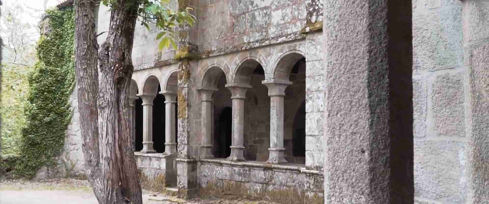
Santa Cristina de Ribas de Sil, located in the municipality of Parada de Sil in the province of Ourense, represents the Ribeira Sacra’s Romanesque architecture at its most elemental and most perfectly preserved. Where Santo Estevo accumulated three cloisters and a Baroque façade across five centuries of patronage, Santa Cristina retains its essential 12th-century character: a single Romanesque church in the Latin cross plan, a semicircular apse, and two surviving wings of the original cloister enclosing a small, mossy courtyard within an ancient oak forest. The effect is of a building that never needed to become more than it was.
The monastery’s documentary history begins with a donation of vineyards to the community dated 876 AD — the oldest written evidence for viticulture in the entire Ribeira Sacra, recently confirmed by the Adegas da Memória archaeological project, which demonstrated through soil science and archaeological analysis that the cultivation patterns around Santa Cristina are consistent with continuous viticultural use from at least this date. This places the monastery’s viticultural practice within the first generation of documented Benedictine presence in the canyon and establishes Santa Cristina as a key site for understanding the origins of the monastic wine economy that shaped the entire region.
The church of Santa Cristina is a compact work of great spatial precision. The entrance portal, with its series of concentric archivolts resting on paired columns, has been compared to the south portal of Ourense Cathedral — a parallel that suggests the same workshop or at least the same master mason was responsible for both, or that the builders of Santa Cristina were working consciously within the stylistic orbit of the cathedral’s masons. The interior, lit by small round-headed windows in the apse, is spare to the point of severity: the walls are plain, the capitals simply carved with geometric and vegetal motifs, and the focal point is entirely the semicircular apse and its contained altar space. This architectural programme of concentrated simplicity, characteristic of Benedictine monastic churches, communicates the priorities of a community that sought to eliminate visual distraction from liturgical attention.
In the 16th century, Santa Cristina was incorporated into Santo Estevo de Ribas de Sil as a dependent priory, a common fate for the smaller Benedictine foundations of the canyon as the centralising reforms of the Castilian crown reorganised the region’s monastic geography. A new cloister wing and an addition to the church tower were built at this time. The community that had operated Santa Cristina as an autonomous house dispersed, and the monastery continued under the administration of monks from Santo Estevo until the Mendizábal confiscations of 1835 dissolved the parent institution. After the dissolution, both Santa Cristina and Santo Estevo were converted to private domestic uses — including, in a historical irony common to the post-confiscation period, use as agricultural storage and stabling. The building that had housed one of the oldest vine-growing communities in Galicia was used to store hay.
The smaller monastic foundations scattered across the canyon and its tributary valleys follow similar patterns of establishment and discontinuity. San Miguel de Eiré, founded in the 10th century, preserves a late 12th-century church with a horseshoe-arched window in its interior that speaks to Mozarabic or pre-Romanesque antecedents. San Paio de Abeleda maintains its remote forest position above the Sil with a small Romanesque church largely untouched by later rebuilding. San Vicente de Pombeiro, Santo Estevo de Atán, and San Fiz de Cangas represent the dispersed network of parish churches that grew from hermit foundations and that served both the monastic communities and the lay populations of the canyon’s villages — a landscape of small, precisely crafted Romanesque buildings whose cumulative presence establishes the religious topography of the whole region.
Ferreira de Pantón: The Only Living Monastery of the Ribeira Sacra
The Cistercian monastery of San Salvador de Ferreira de Pantón, located in the municipality of Pantón in the province of Lugo, is the only foundation in the entire Ribeira Sacra that has maintained continuous monastic life from its medieval establishment to the present day. Where every other canyon monastery was dissolved, converted, repurposed, or abandoned in the aftermath of the Mendizábal confiscations, Ferreira de Pantón survived the 19th century with its community intact — an achievement that makes it, in institutional terms, the most remarkable site in the region, even if it lacks the architectural complexity of Santo Estevo or the antiquity of San Pedro de Rocas.
The monastery’s first documentary reference dates to 924 AD, establishing it within the same 10th-century moment of Benedictine expansion that produced the documented histories of Santo Estevo and Santa Cristina. Its early history as a Benedictine house — and possibly a double monastery housing both monks and nuns, a form common in early medieval Galicia — gave way in 1175 to a Cistercian transformation under the patronage of the Countess Fronilde Fernández, who granted the community to the reformed Cistercian order and inaugurated a new stage of spiritual and economic revitalisation. The Cistercian adoption is the pivotal event in Ferreira’s institutional history, because it was the Cistercian rule — with its emphasis on manual labour, self-sufficiency, and architectural austerity — that gave the community the organisational resilience to survive the subsequent centuries of political turbulence and economic stress.
The architectural ensemble of Ferreira de Pantón is a study in Cistercian plainness applied to Galician granite. The church, built in the 12th century before the Cistercian reform, is a single-nave structure with a semicircular apse whose external walls bear carved architectural details from the earlier Benedictine period — including a column capital carved with a basilisk, the hybrid creature that Saint Bernard reportedly used as a symbol of spiritual danger (whoever looks at it, he cautioned, risks death). Inside, the nave is covered by a coffered ceiling of Mudejar tradition added in the 16th century — an intervention that introduces an Islamic-influenced geometric decoration into a Cistercian space, reflecting the cultural syncretism of the Spanish Renaissance period. The Renaissance cloister, added in the same century, uses stone in the lower section and wood in the upper section, a combination that reflects both the available resources and the economic constraints of a community that was never wealthy by the standards of the great Benedictine houses.
The monastery’s most important contribution to the living culture of the Ribeira Sacra is not architectural but human. A small community of Cistercian nuns — the Bernardas — continues to occupy Ferreira de Pantón today, making it the only nunnery in Galicia that has been reserved for women throughout its entire history. The nuns maintain the canonical hours, practise the ora et labora — pray and work — discipline of the Cistercian rule, and produce the monastery’s traditional artisanal pastries: almendrados (almond cakes), tejas, golosas (butter confections), and coquiños (coconut and almond spheres made with honey harvested from the monastery’s own bees). These sweets, sold to visitors at the monastery gate, represent an unbroken thread of productive monastic life that connects the current community to the agricultural self-sufficiency that built the landscape around them.
The Socalcos: How Medieval Engineers Built Vineyards into Vertical Rock Faces
The socalcos of Ribeira Sacra — the stone-walled terrace platforms that convert near-vertical canyon slopes into viable agricultural land — are the single most labour-intensive constructional achievement in the landscape, and arguably the most technically sophisticated. Their construction required not only an understanding of structural masonry but a detailed empirical knowledge of soil behaviour, water movement, and slope stability that could only have accumulated through generations of observation and correction. The monks who built and maintained these terraces from the 9th century onward were not applying a formal engineering theory but executing a practical intelligence refined by continuous feedback from the slopes themselves.
The constructional logic of a socalco begins with site analysis. Before any stone was laid, the builder needed to understand the local geology — specifically, whether the slope was underlain by sound bedrock close to the surface (which provides a stable foundation for the retaining wall and limits the depth of soil available for vine roots) or by a deeper weathering horizon of decomposed granite (which provides more soil but is more susceptible to internal drainage failure). In the steepest sections of the canyon, where the solid granite bedrock outcrops at or near the surface, the terrace platforms are narrow — sometimes only a metre wide — and the vine training was organised accordingly, with a single row of plants whose roots penetrate the thin soil layer and eventually reach fractured rock below. In sections with deeper weathering profiles, the terraces could be made wider and the vines trained in the traditional Galician style on low trellises of wooden stakes and horizontal wires.
The retaining wall itself is constructed in courses of locally quarried granite and, in the sections below the Sil River, often in the dark slate and schist that underlies the canyon’s eastern flanks. The quarrying method in the Middle Ages involved exploiting the natural fracture lines of the rock — the cleavage planes along which granite separates into roughly tabular blocks under the influence of wedges driven into drill holes. The resulting blocks are irregular in their natural state but sufficiently consistent in thickness to be laid in courses of approximately uniform height. The faces of the wall presented to the slope were left rough; the face presented to the cultivated terrace was sometimes dressed more carefully to provide a clean edge for the terrace platform.
The critical hydraulic element of the socalco design is the treatment of the wall’s base course and the deliberate introduction of permeable sections at regular intervals along the wall face. Rather than laying the lowest course of stone on a continuous impermeable foundation, medieval builders often left it raised slightly above the original slope surface, or incorporated gaps between blocks in the lowest two or three courses, creating a line of outflow points through which water moving down the slope under the terrace could escape before accumulating. On loose granite soils with high permeability, the downslope movement of water during rainfall is rapid and the hydraulic pressure behind an impermeable wall would be sufficient to cause failure within decades. The porous wall design transforms this hydraulic energy from a destructive force into a controlled drainage flow.
The socalcos are not uniform in width across their length: they follow the contour of the slope, widening where the gradient eases and narrowing where it steepens, and they step down the canyon face in a series of irregular flights that bear no resemblance to the formal mathematical terracing of other Mediterranean cultures. This irregularity is not a sign of limited engineering capability but a response to the irregular geology of the granite and slate canyon: the builders were not imposing a grid on the slope but reading the slope and adapting their construction to what they found. The result, viewed from the canyon rim or from the river below, has the visual quality of a living structure — a landscape that appears to have grown into the rock rather than been imposed upon it.
The maintenance demands of the socalco system are continuous and significant. Stone walls on loose substrates shift seasonally under frost action, water pressure, and the mechanical forces of vine root growth. A wall section that collapses after a heavy winter rain must be reconstructed before the spring planting cycle begins, or the terrace platform above will erode in the next rainfall event. Medieval monastic communities maintained this system as a collective institutional responsibility, with lay workers under monastic supervision carrying out the seasonal repairs that kept the terrace network functional. After the dissolution of the monasteries in 1835–1836, this collective maintenance responsibility devolved to individual smallholder families, many of whom lacked the labour to sustain it. The result was a progressive abandonment of the more inaccessible terraces across the late 19th and early 20th centuries — a collapse of the maintenance system that phylloxera and rural emigration accelerated dramatically. The recovery of the system in the late 20th century, driven by the establishment of the Denominación de Origen and the rising international interest in Ribeira Sacra’s wines, required the reconstruction of thousands of metres of collapsed terrace walls — a project that continues today.
The total area of planted vineyard within the Denominación de Origen stands at approximately 1,310 hectares as of 2024, a figure that represents only a portion of the total terraced area in the canyon. Many socalcos that were abandoned in the late 19th and early 20th centuries retain their stone walls in various states of repair but no longer carry vines. The potential vineyard area — the total socalco land that could theoretically be brought back into production with sufficient labour — is substantially larger, estimated at approximately 2,500 hectares. The gap between planted and potential area is not a measure of agricultural failure but of the labour intensity of heroic viticulture: a single hectare of canyon vineyard requires approximately three times the labour of a hectare on a flat or moderately inclined surface, and the economics of production must justify that premium before any additional socalco reconstruction becomes viable.
The Grammar of Granite: Masonry Techniques of the Canyon Monasteries
The monasteries of the Ribeira Sacra and the socalcos of its vineyards are made from the same geological material, cut with overlapping techniques, and assembled according to a masonry tradition that belongs simultaneously to ecclesiastical architecture and agricultural engineering. Understanding the technical character of the stone-cutting that built the canyon’s monasteries illuminates the same intelligence that built its terraces, because in both cases the builders were reading the properties of a single, locally available material — granite — and working within the constraints it imposed.
Galician granite in the Ribeira Sacra varies considerably in grain size and fracture behaviour between formations. The coarser-grained granites of the upper canyon walls tend to fracture along planar joints that produce tabular blocks well-suited to coursed ashlar construction — the laying of squared stone in regular horizontal courses that defines the Galician Romanesque aesthetic. The finer-grained granites and the metamorphic rocks (particularly the schist and slate of the Amandi and Ribeiras do Sil sub-zones) produce thinner, more irregular blocks that are less suited to ashlar construction but well-adapted to the construction of dry-stone or semi-mortared retaining walls where the natural irregularity of the blocks helps create the interlocking surfaces that give dry-stone masonry its structural integrity. Medieval builders in the canyon exploited both properties, using ashlar granite for monastic walls and dressed architectural elements while using the rougher, more irregular stone for the agricultural terraces.
The dressed stone of the canyon’s Romanesque churches reveals a masonry vocabulary of considerable sophistication. Column capitals carved from single blocks of granite show the gradual tool marks of a working process that began with the broad strokes of a mason’s pick, progressed through the finer definition of a flat chisel, and completed with the detailed carving of a punch or gouge. The hardness of granite — significantly higher than the limestone preferred by French and Italian Romanesque builders — meant that Galician carvers could not achieve the deep undercutting and complex foliate patterns of their counterparts working in softer stone. The Galician response to this constraint was characteristic: rather than attempting effects the stone could not sustain, they developed a repertoire of motifs — geometric interlace, animal figures, simple foliate scrolls — that worked with the stone’s properties rather than against them.
The portal archivolts of Santa Cristina de Ribas de Sil demonstrate the mature expression of this aesthetic: multiple concentric arched mouldings of increasing complexity, each carved from a series of individual voussoir blocks whose joints follow the radial lines of the arch, creating a structural and decorative logic that is entirely consistent. The same precision is visible in the cloister arcades of Santo Estevo de Ribas de Sil’s Bishops’ Cloister, where paired columns support arches of dressed granite whose proportions follow the Romanesque canon of column height to arch span with evident care. The master masons who designed these elements had access to pattern books or at minimum to a tradition of transmitted knowledge about architectural geometry, and they applied that knowledge to a material that forgave no errors — an incorrectly cut voussoir in granite cannot be adjusted with mortar and must be replaced or disguised.
The mortar used in the canyon’s Romanesque structures is a lime-based mix whose relative fragility, compared to modern Portland cement, has paradoxically contributed to the buildings’ longevity. Lime mortar accommodates the small seasonal movements of a masonry wall without cracking by deforming slightly under stress; it is also permeable to water vapour, allowing the walls to breathe and preventing the moisture accumulation that destroys buildings repointed with impermeable modern mortars. Many of the canyon’s surviving Romanesque structures retain original medieval mortar in protected joints, and the pale cream colour of weathered lime mortar against the warm grey of Galician granite is one of the defining visual characteristics of the region’s architecture.
Water as Infrastructure: Hydraulic Systems and the Cultural Landscape
The UNESCO candidacy for Ribeira Sacra under the designation Paisaxe Cultural da Auga — Cultural Water Landscape — reflects a fundamental insight about how the canyon landscape was organised and managed across its medieval history: water was not merely a natural resource exploited opportunistically but the central infrastructure around which the entire human geography of the canyon was built. The monasteries needed water for liturgical use, for irrigation, for milling, and for the hydraulic power that drove the mechanical operations of the mill complex. The socalcos needed water managed carefully — neither too much (which would destroy the terraces) nor too little (which would kill the vines). The springs issuing from the canyon walls were sacred sites before they were practical resources, and their sacredness and their utility were understood as expressions of the same divine generosity.
The water mills of the Ribeira Sacra represent the most technically ambitious element of the canyon’s hydraulic infrastructure. The canyon streams feeding the Sil from the tributary valleys — carrying water from the wetter plateau above down through the sheltered canyon environment — provided a consistent hydraulic head that monastic engineers exploited by constructing horizontal-wheel mills (azenhas) at suitable fall points. These mills ground the grain that fed the monastic communities and, in the periods of greatest institutional wealth, processed grain for the surrounding lay population as well, generating revenue that supported the canonical operations of the monastery. The horizontal-wheel design, well-adapted to the moderate water flows and variable heads of the canyon streams, differs from the vertical-wheel mills more common in northern Europe and reflects the Iberian hydraulic tradition inherited from Roman and Islamic antecedents.
The drainage systems of the socalcos constitute a second tier of hydraulic infrastructure, operating at the agricultural rather than the mechanical scale. The deliberate permeability built into the retaining walls, described in the previous section, is only one element of a larger system that also includes cut channels along the back of terrace platforms, directing accumulated seepage water laterally to points where it can be released down the slope without carrying soil with it. These lateral drains — carved into the bedrock in some sections, built up with stone in others — represent a level of hydraulic design thinking that treats the entire hillside as an integrated water management system rather than a collection of individual terraces. The same design logic appears in the drainage systems of monastery buildings, where channels cut below cloister floor levels directed rainwater and waste water away from the foundations and toward the kitchen gardens or the mill race.
Sacred water — springs, holy wells, baptismal fonts — completes the hydraulic picture of the Ribeira Sacra. The canyon walls produce numerous springs from the fracture zones where groundwater moving through the upper plateau encounters the impermeable granite and is forced out laterally. Many of these springs were associated with specific saints and with healing properties that predated and outlasted the particular religious occupants of any given site. At San Pedro de Rocas, a spring associated with San Bieto (Saint Benedict) emerges from a rock-cut hollow below the church and is still the destination of a local pilgrimage tradition. At Santo Estevo, the forested ravine below the monastery contains springs that fed the monastic water supply through gravity-fed lead pipes — a Roman technology reused by medieval builders who found it as reliable in the 10th century as it had been in the 2nd.
The hydraulic dimension of the Ribeira Sacra is also inscribed at the landscape scale in the catamaran and boat routes that traverse the canyons, offering the most dramatic view of the relationship between the socalcos, the monasteries, and the water that separates them. The river itself was the principal communication route of the medieval canyon: timber and wine travelled downriver on flat-bottomed boats, grain came upriver on the return journey, and the ferries that connected the canyon’s communities were as much part of the transport infrastructure as the narrow paths cut into the cliff face. The same river that carved the canyon and provided the hydraulic head for the mills was the road on which the products of the monastery’s agricultural system travelled to market.
From Roman Amphora to Denominación de Origen: Canyon Viticulture Through the Ages
The history of wine production in the Sil Canyon spans at least two millennia, beginning with the Roman legions who arrived in Galicia around 137 BCE in search of gold and remained long enough to plant vines and construct the first stone terracing along the canyon walls. Roman wine from the Amandi sub-zone — south-facing slopes above the Sil with the warmest, most sheltered microclimate in the canyon — achieved sufficient renown that ancient sources describe it as the “Liquid Gold of the Sil,” served at the imperial table. The Romans’ contribution to the canyon viticulture was not merely the introduction of the vine — Phoenician and Carthaginian traders had already brought viticulture to the Galician coast in the pre-Roman period — but the construction of the stone platforms that made cultivation on these extreme gradients possible and the development of an export economy that connected the remote canyon to Mediterranean markets.
When the Roman administrative system dissolved in the 5th century and Galicia passed through the Suevian kingdom to eventual incorporation into the Visigothic and then Asturian-Leonese political system, viticulture in the canyon survived as a local practice but lost its connection to the export economy. It was the Benedictine monasteries of the 9th and 10th centuries that reconnected canyon wine to an institutional demand structure capable of sustaining the socalcos and their labour requirements. The monasteries needed wine for liturgical use — the Eucharist — and for the hospitality extended to pilgrims traversing the Camino de Santiago routes that passed through Galicia. A monastery without its own wine supply was dependent on trade in a commodity that was both essential and expensive; the incentive to maintain and expand the canyon’s terraced vineyards was therefore institutional and liturgical as much as agricultural and economic.
The 876 AD donation of vineyards to Santa Cristina de Ribas de Sil — the oldest written record of canyon viticulture — was confirmed by the Adegas da Memória archaeological project, which used soil science and archaeological analysis to demonstrate that the cultivation patterns around the monastery are consistent with at least 1,000 years of continuous viticultural use. This finding places the origins of documented medieval viticulture in the canyon squarely within the Benedictine era and confirms that the socalcos associated with the monastery were in use before the end of the 9th century. The monks of Santa Cristina were not planting vineyards on bare rock; they were maintaining an agricultural infrastructure that had been established — by Roman and possibly pre-Roman hands — on platforms of stone whose construction was itself a precondition for any viticulture at all on such slopes.
The grape varieties cultivated in the medieval canyon are not entirely recoverable from documentary evidence, but the strong likelihood is that the ancestors of the current principal varieties were already present. Mencía — the dark-skinned, aromatic red grape that dominates modern Ribeira Sacra production and that makes the region the only wine-producing zone in Galicia to produce more red than white wine — was documented in Galicia from the 12th century and appears to be adapted specifically to the slate and granite soils of the canyon environment. Godello, the white variety that produces the region’s most acclaimed white wines, has an even longer documented presence in the Galician interior. The Benedictine and Cistercian monasteries that maintained the canyon’s viticulture were selecting for these varieties over centuries of empirical observation — culling plants that performed poorly, propagating those that gave consistent yields and quality on the difficult terrace soils — long before any formal ampelographic system existed to name or classify them.
The Mendizábal confiscations of 1835–1836 severed the institutional connection between monasticism and canyon viticulture that had sustained the socalco system for a thousand years. When the monastic communities were dissolved and their assets transferred to the state, the vineyards that had been maintained collectively by communities of monks or nuns were divided among small private owners who lacked the capital and labour to manage them at the same intensity. Many terraces were abandoned, their walls left to shift and collapse over successive winters. The phylloxera epidemic that reached the region in the late 19th century completed the devastation: the louse that feeds on vine roots killed plants across the entire planted area, and the grafting onto resistant American rootstock that allowed European viticulture to recover was a slow and expensive process that the labour-depleted, capital-poor smallholder economy of the canyon struggled to complete before widespread rural emigration further reduced the available workforce in the early 20th century.
Dissolution, Phylloxera, and the Long Interruption
The century between roughly 1836 and 1950 represents the most severe disruption in the continuous history of monastic and viticultural life in the Ribeira Sacra. Two separate shocks — one institutional, one botanical — combined to dismantle a system of land management that had functioned with remarkable continuity for a thousand years, and the landscape they left behind was one of partial abandonment, collapsing stone walls, and overgrown terraces from which the vine had been driven.
The Mendizábal confiscations, named for the Spanish finance minister who promoted the 1835 law requiring the dissolution of religious houses and the sale of their assets, were intended to resolve the Spanish state’s chronic fiscal crisis by converting Church land into revenue. In the Ribeira Sacra, the practical consequence was the dissolution of every monastic community except Ferreira de Pantón — which survived through a combination of legal circumstances and the persistence of its Cistercian nuns — and the transfer of monastic buildings to private ownership or state control. The buildings were used for whatever purposes their new owners found convenient: storage, housing, stabling. Santo Estevo became, at various points in the 19th century, a private residence and an agricultural outbuilding. Santa Cristina was used to store hay. The accumulated institutional memory of monastic stone management — the knowledge of which walls needed reinforcing before winter, which drainage channels needed clearing after spring floods, which sections of socalco were vulnerable to root damage — dissolved with the communities that had held it.
The phylloxera epidemic arrived in the Ribeira Sacra in the late 19th century, a consequence of the global spread of the North American root louse Daktulosphaira vitifoliae that had already devastated vineyards across France, Italy, Portugal, and most of Spain. The canyon’s isolation had temporarily protected it, but by the 1890s the louse had reached even the remote socalcos and was destroying the root systems of vines that had been grafted from cuttings passed down through monastic communities over centuries. Recovery required grafting all surviving or replanted vines onto resistant American rootstock, a technically straightforward but labour-intensive process that proceeded slowly in a region where the available agricultural workforce was simultaneously declining through emigration to industrial Galician cities and to Latin America.
The recovery of canyon viticulture in the second half of the 20th century was driven by a new generation of producers who recognised both the quality potential of the Mencía grape in its terraced canyon environment and the marketability of the heroic viticulture narrative. The establishment of the Denominación de Origen Ribeira Sacra in 1996 provided the institutional framework — quality controls, geographic delimitation, marketing infrastructure — that allowed small producers to command prices commensurate with the exceptional labour costs of canyon viticulture. The DO’s establishment also created an incentive to reconstruct abandoned socalcos and bring additional terraced land back into production, reversing a century of progressive abandonment.
Heritage Recognition and the Contemporary Ribeira Sacra
The Ribeira Sacra today occupies an unusual position in European cultural heritage: a living landscape where the medieval engineering achievement of the socalcos is simultaneously an active agricultural system, a tourism resource, and the subject of international heritage recognition processes. The trajectory from Mendizábal confiscation through phylloxera devastation to Biosphere Reserve and UNESCO candidacy spans less than two centuries and encompasses one of the most dramatic reversals of cultural landscape fortune in Iberian history.
The region was designated a UNESCO Biosphere Reserve in 2022, recognising the integration of human land use and natural systems that characterises the canyon’s ecology — the Natura 2000 site protects rare bird species and mammal populations including otters and several bat species, while the viticultural landscape it encompasses represents exactly the kind of sustainable agricultural-ecological interaction that Biosphere Reserve criteria are designed to recognise. The Biosphere Reserve designation preceded and prepared the ground for the more ambitious World Heritage candidacy, which was submitted formally to the UNESCO World Heritage Centre in Paris in February 2025 under the designation Paisaxe Cultural da Auga: Ribeira Sacra — Cultural Water Landscape: Ribeira Sacra.
The current candidacy represents a substantially revised approach from a previous nomination that was withdrawn in 2020 following an ICOMOS pre-evaluation that identified weaknesses in the unified management framework and in the definition of the property’s boundaries. The new nomination, covering approximately 16,973 hectares across the provinces of Lugo and Ourense, foregrounds the relationship between water, human settlement, and cultural landscape as its central value argument, identifying six defining attributes: the canyon and valley forms sculpted by water; the water heritage of all periods including hydraulic industrial infrastructure; the unique drainage systems of the socalcos; the hermit and monastic tradition rooted in the area; the patterns of settlement defined by watercourses and organised through the parish system; and the biocultural heritage of festivals, traditions, and the sacralisation of springs and water features. The ICOMOS evaluation visit was completed in October 2025, and the World Heritage Committee’s consideration of the candidacy proceeds through the standard process toward a decision expected in summer 2026.
The tourism economy built around this heritage is substantial and growing. The canyon boats and catamarans that traverse the Sil below the monastery promontories carry tens of thousands of visitors annually. The wine tourism infrastructure — winery visits, tastings, vineyard walks — attracted more than 130,000 visitors in the first nine months of 2024 alone. The Parador Nacional at Santo Estevo offers the most immersive engagement with the monastic heritage, placing overnight guests within the three cloisters of an 11th-century Benedictine foundation. And the small community of Cistercian nuns at Ferreira de Pantón continues to sell almond pastries to visiting pilgrims, enacting a form of monastic hospitality that has operated on the same spot for eight centuries. The vine and the ashlar that built this landscape are still present, still working, still producing — in wine, in stone, in the disciplined daily life of the canyon’s smallest surviving community.
Frequently Asked Questions About the Sil River Canyon and Medieval Monastic Engineering
What does the name “Ribeira Sacra” mean and where does it come from?
Ribeira Sacra translates as “Sacred Riverbank” in Galician. The name almost certainly originated as a scribal error: medieval monks receiving land donations along these rivers recorded the location as beside a regueira (small stream), which a later copyist transcribed as ribeira (riverbank). The word sacra (sacred) was applied naturally to a landscape containing more than thirty medieval monasteries, hermitages, and churches. The erroneous transcription was perpetuated when the name was adopted for the Denominación de Origen wine appellation established in 1996, giving the region a formally incorrect but poetically precise identity that perfectly captures the dual nature of its rivers and its religious heritage.
When were the terraced vineyards of the Sil Canyon first established?
The earliest stone terracing in the Sil Canyon was carried out by the Romans, who arrived in Galicia around 137 BCE and constructed vine-growing platforms along the canyon walls. The Adegas da Memória archaeological project recently confirmed continuous viticulture around the monastery of Santa Cristina de Ribas de Sil from at least 876 AD — the same date as the oldest written record of canyon wine-growing, a donation of vineyards to the Santa Cristina monastic community. The systematic medieval expansion of the terrace system was the work of Benedictine and Cistercian monks from the 9th through 13th centuries, who built upon the Roman foundations and extended the socalco network to the near-vertical slopes that now define the region’s heroic viticulture landscape.
What monastic orders were active in the Ribeira Sacra?
Benedictine communities dominated the Sil sub-zone and established the majority of the canyon’s medieval foundations, including Santo Estevo de Ribas de Sil, Santa Cristina de Ribas de Sil, and San Pedro de Rocas (which was eventually absorbed into the Benedictine Congregation of San Benito de Valladolid as a priory). Cistercian houses were more concentrated along the Miño River corridor, with Ferreira de Pantón (which joined the Cistercian order in 1175) being the most significant. Several foundations began as double monasteries — housing both monks and nuns — before the 12th-century reform movements suppressed this form of community life. The Cistercian influence is architecturally visible in the relative plainness of Ferreira de Pantón’s later buildings, reflecting the order’s explicit rejection of decorative excess.
Is San Pedro de Rocas older than Santo Estevo de Ribas de Sil?
San Pedro de Rocas has the earlier documented founding date: its foundation inscription records a settlement of hermits in 573 AD, making it the oldest known Christian monument in Galicia. Santo Estevo is first documented in 921 AD, though tradition attributes its founding to Saint Martin of Braga around 550–555 AD — which would make it roughly contemporary with San Pedro de Rocas if the tradition is correct. In terms of architectural survival, San Pedro de Rocas is the more ancient-looking site because its rock-cut church was built in the 6th century and never substantially rebuilt, while Santo Estevo’s current visible fabric dates primarily from the 12th to 18th centuries, with no above-ground structure surviving from the 10th-century restoration under Abbot Franquila.
How are the socalcos maintained today?
The stone retaining walls of the socalcos require seasonal inspection and repair after winter rains, which cause the loose granite soils to settle and shift, placing lateral pressure on the wall faces. Individual vineyard owners are responsible for the walls on their own terraces, creating a distributed maintenance system that works well on actively cultivated land but leaves abandoned terraces — of which thousands of hectares remain in the canyon — in progressive states of collapse. The establishment of the Denominación de Origen in 1996 and the rising value of Ribeira Sacra wines have made terrace reconstruction economically viable for producers expanding their planted area, and considerable socalco reconstruction has been carried out in the past thirty years. Harvest on all canyon vineyards is conducted entirely by hand, with the picked grapes transported to the canyon rim in cable systems or small motorised carriers on the steepest sections where even basket-carrying is unsafe.
What grape varieties grow in the terraced vineyards of the Sil Canyon?
Mencía is the dominant red variety of Ribeira Sacra, accounting for the majority of production and making the region the only wine zone in Galicia that produces more red than white wine. Mencía thrives on the dark slate and granite soils of the canyon’s south-facing terraces, producing wines of aromatic intensity, moderate tannin, and distinctive minerality. Brancellao and Merenzao are minority red varieties cultivated in smaller quantities by producers seeking additional complexity. Among whites, Godello is the most highly regarded variety, producing wines of considerable depth and mineral tension on the canyon’s deeper soils. Albariño, Treixadura, and Loureira are grown in smaller quantities, particularly in the Miño sub-zones where the Atlantic influence produces a more aromatic white wine character.
Is the Ribeira Sacra a UNESCO World Heritage Site?
As of mid-2026, the Ribeira Sacra is a candidate for inscription on the UNESCO World Heritage List but has not yet been inscribed. Spain submitted the formal candidacy — titled Paisaxe Cultural da Auga: Ribeira Sacra (Cultural Water Landscape: Ribeira Sacra) — to the World Heritage Centre in Paris in February 2025. The ICOMOS advisory body conducted its evaluation site visit in October 2025, and the World Heritage Committee is scheduled to consider the candidacy at its 2026 session. The region has been on Spain’s UNESCO Tentative List since 1996 and has held UNESCO Biosphere Reserve status since 2022. A previous candidacy was withdrawn in 2020 after ICOMOS raised concerns about management framework and boundary definition, which the current nomination has addressed through a new conceptual framing centred on water culture.
What happened to the canyon monasteries after the 1835 confiscations?
The Mendizábal confiscations of 1835–1836 dissolved every monastic community in the Ribeira Sacra except Ferreira de Pantón, whose Cistercian nuns survived through particular legal circumstances. The abandoned monasteries were transferred to private ownership or state control and repurposed for agricultural storage, housing, and other secular uses. Santo Estevo and Santa Cristina were both used as stabling at various points. Many smaller hermitages and priories fell into ruin entirely. The 20th century brought gradual recognition of the architectural and historical significance of the surviving structures, leading to state protection and, in the case of Santo Estevo, conversion to a Parador Nacional hotel — a use that has preserved the building while providing the revenue to maintain it. San Pedro de Rocas was declared a national monument in 1923.
How does the canyon microclimate affect viticulture differently from the surrounding plateau?
The Sil Canyon creates a thermal environment substantially warmer and drier than the Atlantic plateau above it. The canyon walls act as solar collectors, absorbing daytime heat in the dark granite and releasing it gradually overnight, extending the vine’s growing season by several weeks compared to conditions on the plateau rim. The canyon also provides protection from the cold Atlantic westerlies that carry Galicia’s high rainfall, reducing the risk of fungal disease that is a constant challenge in Atlantic viticulture. The result is that the canyon can support the cultivation of Mencía — a variety that requires substantial heat accumulation to achieve phenolic ripeness — at a latitude (approximately 42°N) where it would fail to ripen adequately without the canyon’s thermal advantage. The microclimate paradox of the Ribeira Sacra is that the most Atlantic region of Spain grows the most Mediterranean of its wine styles.
What did the Adegas da Memória archaeological project reveal about canyon viticulture?
The Adegas da Memória project, a multi-disciplinary investigation combining soil science and archaeological analysis, examined the land surrounding the monastery of Santa Cristina de Ribas de Sil and produced results that both confirmed and refined the historical record of canyon viticulture. The project’s findings established that the soil and archaeological signatures of vine cultivation around Santa Cristina are consistent with a continuous practice dating to at least 876 AD — exactly coinciding with the oldest written document to mention vineyards in the area, a donation made to the monastery in that year. This alignment of soil science and documentary evidence is unusual in medieval agricultural archaeology and provides the most rigorous confirmation available for the millennium-long continuity of canyon wine-growing. The results were submitted as supporting evidence for the Ribeira Sacra’s UNESCO World Heritage candidacy, underpinning the claim to exceptional universal value based on the longevity and continuity of the cultural landscape.