The Silent Frontiers: Cultural Geography and Templar Urbanism of the Maestrazgo Highlands
Straddling the eastern edge of the Sistema Ibérico where the highlands of Teruel bleed into the northern reaches of Castellón, the Maestrazgo is one of the most coherently medieval landscapes still standing in Europe — a territory carved not by gentle accumulation but by the hard logic of military occupation, religious zeal, and frontier administration. The Knights Templar and the military orders that followed them did not merely defend this land; they invented it, imposing a spatial order on a rugged upland that still defines the relationship between settlement, topography, and civic identity across a dozen stone towns. This article examines the cultural geography of the Maestrazgo Highlands, the urban principles the military orders brought to bear on a contested frontier, and the astonishing degree to which that medieval world remains legible in the landscape today.
Key Takeaways
- Name and origin: The name “Maestrazgo” derives directly from maestre — the title of the masters of the military orders who administered the region following the Christian reconquest of the late twelfth and early thirteenth centuries, making the very name of the land an inscription of military governance.
- Multiple orders, overlapping jurisdictions: Three distinct military orders held authority across the Maestrazgo: the Knights Templar controlled the encomiendas of Cantavieja and Castellote; the Order of San Juan del Hospital held Aliaga; the Knights of Calatrava administered Molinos. Their overlapping but distinct urban and institutional legacies explain the regional variation visible across the surviving towns.
- UNESCO and heritage designations: The Maestrazgo Cultural Park holds designation as a UNESCO Global Geopark. Several shelters within the park form part of the Rock Art of the Mediterranean Arch of the Iberian Peninsula, a UNESCO World Heritage Site. The region also records over 615 archaeological sites, ten historical sites and 21 monuments declared Assets of Cultural Interest (BIC), and thirteen medieval villages recognised as National Monuments.
- Urban survival: Morella, Mirambel, Cantavieja, and Puertomingalvo represent four of the most completely preserved medieval urban ensembles in the Iberian Peninsula. Morella is one of only four towns in the Valencian Region to retain its entire defensive perimeter; Mirambel’s walled complex earned a Europa Nostra award for conservation excellence.
- Population and geography: With an average of approximately two inhabitants per square kilometre, the Maestrazgo is among the most sparsely settled territories in western Europe. This near-depopulation, the paradoxical consequence of centuries of demographic decline, is the primary reason the medieval urban fabric survived: there was never the pressure or capital to demolish and rebuild.
- Deep time: The Maestrazgo’s human story extends far beyond the medieval orders. The cave paintings of Morella la Vella, dating to between 7,200 and 7,400 years ago and included within the UNESCO World Heritage Rock Art site, contain the oldest known depiction of archery combat in the world, anchoring the “frontier” concept in a prehistoric geography of conflict and movement that predates the Reconquista by millennia.
People Also Ask About the Maestrazgo Highlands
What are the Maestrazgo Highlands and why are they historically significant?
The Maestrazgo Highlands form a natural and historical region at the eastern end of Spain’s Sistema Ibérico mountain range, spanning the south-eastern part of the province of Teruel in Aragon and the northern interior of Castellón in the Valencian Community. The region takes its name from the maestres — the masters of the military orders who governed it following the Christian reconquest of the late twelfth century. Its historical significance rests on several interlocking dimensions: it was the principal laboratory in which the military orders of medieval Aragon developed their model of frontier urbanism, creating towns whose spatial organisation still reflects the logic of defence, ecclesiastical authority, and civic cohesion that the Templars and Hospitallers installed over several generations. The region also holds a remarkable density of intact medieval fabric — walled towns, commandery churches, Gothic civic buildings, and defensive gates — that survived into the twenty-first century largely because post-medieval depopulation removed the economic incentive for demolition and redevelopment.
Which military orders controlled the Maestrazgo and what role did they play?
Three principal military orders held authority across the Maestrazgo in the medieval period. The Knights Templar administered the encomiendas — territorial command districts — of Cantavieja and Castellote from the late twelfth century, building the castles, granting the population charters, and laying down the urban street patterns that remain visible today. The Order of San Juan del Hospital governed the encomienda of Aliaga, while the Knights of Calatrava held Molinos. The Templars dominated from their arrival around 1196 until the order’s dissolution in 1312, after which their properties in the Maestrazgo passed to the Knights Hospitaller, who administered the territory until the abolition of feudal jurisdiction in 1813. It is the Templar period, above all, that forged the region’s urban identity: the encomienda system imposed a disciplined territorial logic, the population charters attracted settlers to a hostile highland environment, and the placement of castle, church, and plaza established the spatial grammar still evident in Cantavieja, Mirambel, and Castellote.
What UNESCO designations does the Maestrazgo hold?
The Maestrazgo holds three distinct categories of UNESCO recognition. The Maestrazgo Cultural Park carries designation as a UNESCO Global Geopark, recognising its exceptional geodiversity, palaeontological heritage — including over 76 catalogued dinosaur sites — and cultural landscape. Several rock art shelters within the park form part of the Rock Art of the Mediterranean Arch of the Iberian Peninsula, inscribed on the UNESCO World Heritage List; among these, the paintings of Morella la Vella are particularly remarkable, depicting scenes including the oldest known representation of archery combat, dated to between 7,200 and 7,400 years ago. Additionally, the Tamboradas drum-beating traditions and the Dry Stone Construction technique practised across the region are inscribed on UNESCO’s Representative List of the Intangible Cultural Heritage of Humanity.
What makes the medieval urbanism of the Maestrazgo towns architecturally distinctive?
The urban form of the Maestrazgo towns reflects a coherent set of planning principles imposed by the military orders during the thirteenth and fourteenth centuries. Towns were invariably positioned on commanding promontories or ridgelines, maximising defensive visibility across the highland valleys while making the settlement legible from a distance as a statement of power. The spatial sequence — castle dominating the upper town, commandery church anchoring the civic core, arcaded plaza providing the commercial and administrative centre, and complete defensive wall defining the perimeter — is repeated across Cantavieja, Morella, Puertomingalvo, and Mirambel with such consistency that it constitutes a recognisable Templar urban vocabulary. Gothic civic architecture — town halls, noble palaces, loggias — developed within this framework during the fourteenth and fifteenth centuries, adding a layer of Levantine Gothic character to towns that remained fundamentally military in their spatial logic. The completeness of this ensemble is what distinguishes the Maestrazgo from comparable medieval towns in western Europe: the subsequent absence of industrial or commercial development pressure left the medieval layers intact and legible.
Extended multi-day tours – 5+ days
Featured Aragon Multi-Day Tour Packages

12 days
Spain – Hiking in the Sierra de Guara 12 Days
- ✓ Comprehensive Aragon tour
- ✓ Expert local guides included
- ✓ All accommodation arranged
- ✓ Transportation provided
7 days
Self Drive Hiking Adventure in the Spanish Pyrenees 7 Days
- ✓ Booking needs min. 2 travelers
8 days
Northern Spain – Aragon Sierra de Guara (8 days)
- ✓ Comprehensive Aragon tour
- ✓ Expert local guides included
- ✓ All accommodation arranged
- ✓ Transportation provided
Multi-day tour packages powered by TourRadar. Prices and availability subject to change.
Introduction: Reading a Landscape of Discipline
There is a particular quality of silence in the Maestrazgo that travel writing regularly reaches for and rarely captures adequately. It is not the silence of emptiness — though the plateau grasslands between towns can extend for kilometres without a building — but the silence of a world that happened, fully and violently, and then stopped. The streets of Mirambel do not feel abandoned; they feel paused. The walls of Cantavieja do not suggest ruin; they suggest a confidence in permanence that outlasted the institution that built them. The Maestrazgo is a landscape that registers the medieval period with extraordinary fidelity not despite its remoteness but because of it.
The region sits at the eastern margin of the Iberian interior, where the plateau finally begins its descent toward the Mediterranean. Its rivers — the Guadalope, the Bergantes, the Cantavieja — cut deep gorges through limestone massifs before eventually finding the Ebro or the sea. The altitude is consistent and considerable: most settlements sit above 1,000 metres, several above 1,200. The climate is one of extremes — long, bitter winters and short, intense summers — that made the territory difficult to hold and costly to supply during the critical decades of the twelfth and thirteenth centuries when the military orders were building the institutions that would define it.
That the Maestrazgo became what it became is not an accident of geography but a consequence of it. The highlands occupied a strategic position between the former Taifa kingdom of Valencia, not yet incorporated into the Christian polity, and the expanding Kingdom of Aragon pressing south. Whoever controlled the Maestrazgo controlled the highland approaches to the rich coastal plain. The military orders understood this and built accordingly, and the towns they built — Cantavieja on its ridge at 1,200 metres, Morella on its impossible rock, Puertomingalvo on its cliff at 1,456 metres — announce that understanding in stone to any traveller who approaches from any direction.
The Geography of Isolation: Understanding the Maestrazgo Highlands
The Maestrazgo occupies the eastern termination of the Sistema Ibérico, the long arc of mountains that separates the Meseta — Spain’s central plateau — from the Mediterranean littoral. The region is mountainous, deeply dissected, and oriented around a series of river valleys that provide the only practical lines of movement through terrain that is otherwise composed of limestone ridges, karst formations, and sudden escarpments. The Guadalope River and its tributaries provide the organisational spine of the Aragonese Maestrazgo; to the south, in Castellón, the rivers draining into the Ebro and the Mijares systems define the Valencian sector known as the Maestrat.
The Iberian Range in this area is characterised by what geologists describe as a dry mountain land: deeply incised valleys cut through yellow-brown limestone formations laid down during the Mesozoic, when the area was periodically covered by a warm inland sea. The fossils of that sea — corals, marine invertebrates, and the bones of the dinosaurs that populated the coastal environments between marine incursions — are one of the defining features of the landscape, with over 76 catalogued palaeontological sites contributing to the Maestrazgo Cultural Park’s status as a UNESCO Global Geopark. The crystal caves of Molinos, the petrified trunk forests near Castellote, and the natural organ-pipe formations known as the Órganos de Montoro near Villarluengo are products of this deep geological history, visible in the same landscape as the medieval walls.
The climate is continental with an intensity unusual even by Iberian highland standards. Altitude amplifies the seasonal extremes: January temperatures in Cantavieja regularly fall well below freezing, while July brings heat that bakes the limestone and concentrates the scent of thyme and rosemary across the plateau. Snowfall is common and sometimes prolonged. Historically, this climate defined the rhythms of transhumance — the seasonal movement of livestock between highland summer pastures and lowland winter grazing grounds — that sustained the medieval and early modern economy and imprinted the landscape with a network of cañadas (droving roads) that still cross the comarca.
The consequences for settlement are profound. The natural defences that the terrain provides — promontories above river gorges, ridges with commanding views — were exactly the locations the military orders selected for their principal towns, but building and maintaining a permanent population in such terrain required active institutional effort. The extraordinary density of population charters issued by the Templars and other orders in the late twelfth and thirteenth centuries is a direct response to the geographic challenge: without systematic incentives, settlers would not stay.
From Iberia to Aragon: A Palimpsest of Civilizations
The Maestrazgo’s human occupation extends deep into prehistory. The rock art shelters of the region belong to the broader tradition of Levantine art that extends across the Mediterranean arc of the Iberian Peninsula, inscribed as a UNESCO World Heritage Site for its exceptional quality and chronological range. The paintings of Morella la Vella, located in the limestone cliffs approximately six kilometres from the medieval town, are among the most studied in this group. Dated to between 7,200 and 7,400 years ago, they depict hunting scenes, human figures, and most remarkably, a battle sequence now recognised as the oldest known representation of organised archery combat in the world — a scene of two groups of bowmen firing at each other across a confrontational space. The prehistory of the Maestrazgo, in other words, is itself a prehistory of the frontier.
The Iberian tribe known as the Ilercavones occupied the lower valleys of the Maestrat during the pre-Roman period, building hill settlements on the same commanding promontories that would later be selected by the military orders. The Romans followed, establishing administrative infrastructure and integrating the highland routes into the broader network connecting the Ebro basin to the Mediterranean coast. The town of Morella traces documented occupation through this sequence: the hill that carries the medieval castle and town was first a Visigothic settlement, then an Islamic stronghold.
The Moors held the Maestrazgo as part of the broader Islamic presence in the eastern Iberian Peninsula. The toponym Morella itself is of Arabic derivation, and the Islamic spatial legacy is visible in the organic street patterns of several towns, where the rigid grid of the Reconquista overlay meets the curvilinear fabric of pre-existing Islamic settlement. Arabic influence is also detectable in the agricultural landscape — the terracing, the irrigation vocabulary, the organisation of productive land around water sources — that the subsequent population managed without necessarily understanding its origins.
The Christian conquest of the Maestrazgo was not a single event but a process extending from the late twelfth century into the mid-thirteenth. Cantavieja was taken from its Arab defenders in 1197 and immediately assigned to the Knights Templar. The conquest of the region was completed by King Jaume I of Aragon, whose entry into Morella is commemorated in the town’s historiography as the defining moment of its medieval history. Jaume I is the king who settled the region definitively, organised the allocation of territory to the military orders, and set in motion the process of urban foundation that created the Maestrazgo as a cultural and geographic entity.
The Military Orders and the Forging of Maestrazgo Identity
The name of the region tells the foundational story. Maestrazgo derives from maestre — the title of the grand master who headed each military order, from whose authority all administrative, judicial, and military power within the encomienda ultimately flowed. The region was, quite simply, the territory of the masters, a designation that carried institutional weight in every document, every population charter, every adjudication of land rights issued across the highlands for more than a century.
Three military orders divided the territory between them, and their distinct jurisdictional cultures produced the variations in architecture, urban form, and institutional character visible across the surviving towns. The Knights Templar controlled the encomiendas of Cantavieja and Castellote, the two largest and most strategically significant command districts. The Order of San Juan del Hospital — the Hospitallers — held the encomienda of Aliaga. The Knights of Calatrava, the Castilian order, administered Molinos. Each order operated with a degree of independence within its encomienda, appointing its own commandants, issuing its own charters, and building its own castle and church to its own standards. The variety within the Maestrazgo’s medieval fabric is in part the variety of competing institutional aesthetics operating within a shared spatial logic.
The Templar Encomiendas: Cantavieja, Castellote, and the Architecture of Command
The Templar encomienda system was a sophisticated instrument of territorial administration. Each encomienda was a hierarchically organised district centred on a commandery — a fortified complex combining castle, residential quarters, granaries, stables, and a chapel — that served as the administrative, military, and economic hub of the surrounding territory. The comendador (commandant) appointed to run each encomienda held judicial authority over the dependent settlements, collected dues, organised military service, and was responsible for the physical maintenance of the fortifications.
Cantavieja, assigned to the Templars immediately after its conquest in 1197, became the most important Templar centre in the Aragonese Maestrazgo. The town sits at 1,200 metres above sea level on a craggy ridge that resembles, as one Spanish source memorably describes it, the hull of a ship overturned on a sea of mountains. The Templar castle occupied the highest point of the ridge, commanding views over the surrounding valleys in every direction. Below the castle, the town spread along the ridge in the characteristic pattern of military order urbanism: a sequence of terraced streets descending from the fortress, each level connected by steep lanes and arched passages, with the principal plaza — the arcaded square that today is considered one of the finest in Aragon — serving as the civic and commercial heart of the settlement.
The castle of Castellote, the second great Templar stronghold of the Maestrazgo, occupied an equally dramatic position above the Guadalope gorge. Today this castle houses an Interpretation Centre dedicated to the Templar presence in the region, one of several heritage interpretive facilities across the comarca that have converted the remains of military order infrastructure into public cultural institutions. The adjacent keep, part of the same Templar complex, speaks to the scale of the fortification programme the order pursued across the highlands — a programme that consumed enormous resources over several generations and produced a landscape of hilltop silhouettes recognisable from any approach.
The Fuero System: Population Charters and the Making of Urban Society
The military orders did not only build castles. Their most consequential contribution to the Maestrazgo’s urban character was institutional rather than architectural: the systematic issuance of population charters — fueros or cartas de población — granting specific rights, exemptions, and obligations to settlers willing to establish themselves in the newly conquered highlands. These documents were instruments of deliberate colonisation, offering fiscal privileges, legal protections, and access to common lands in exchange for permanent residence and military service within the encomienda.
The charters shaped the spatial organisation of the towns as directly as the castles did. By specifying the rights attached to particular plots, defining the obligations of residents to the encomienda, and establishing the civic institutions — council, market, fair — around which urban social life would organise itself, the fueros created the legal and social infrastructure that made the towns viable. The arcaded plazas that are among the most visible surviving features of the Maestrazgo towns are not merely architectural choices; they are the physical realisation of the market and assembly rights encoded in the population charters, translated into stone and arcade over the generations that followed the initial grants.
The persistence of the fuero framework also helps explain the remarkable degree of civic self-organisation visible in the surviving architectural record. Gothic town halls, noble palaces, loggias, and hospitals — all built at civic or private rather than military-order expense — proliferated in the Maestrazgo towns during the fourteenth and fifteenth centuries, a period when the initial military imperatives had stabilised and the institutional framework the orders had established was producing a genuinely urban culture in the highlands. The wealth of fourteenth-century civic Gothic in Cantavieja, Mirambel, Puertomingalvo, and Morella reflects a society that had grown into the institutional structures the military orders created and was now expressing its own character through architecture.
The Urbanism of the Military Orders: Spatial Order on a Contested Frontier
The towns of the Maestrazgo share a spatial vocabulary so consistent that it is possible to speak of a distinct mode of military order urbanism, a set of planning principles that express themselves across a series of settlements built in different decades by different commandants but animated by a shared institutional logic. Understanding this vocabulary is the key to reading the Maestrazgo landscape, because it reveals the intentions inscribed in the physical arrangement of streets, buildings, and open spaces — intentions that are as legible today as they were when the first settlers occupied their plots.
Hilltop Positioning and the Logic of Defensive Visibility
The choice of hilltop sites is the most fundamental principle of military order urbanism in the Maestrazgo, and it reflects a logic that is simultaneously military and symbolic. Every major town in the region sits on an elevated position that provides defensive advantage: the castle occupies the highest point, the walls follow the natural contours of the promontory, and the approaches to the town require climbing through terrain that the defenders can survey and control. But the positioning is also an act of communication. A hilltop town announces its presence across the landscape in a way that a valley settlement cannot, projecting the authority of the institution that built it across the surrounding territory.
Morella, on its impossible rock rising from the plains of Els Ports in Castellón, is the supreme expression of this principle. The rock is not merely elevated but vertical — a limestone monolith whose sides are virtually impassable, allowing the medieval engineers to build walls that followed the natural cliff edges and a castle that occupies the summit with the confidence of a structure whose primary defences are geological. From the approaches to the town, Morella appears as a silhouette at once architectural and geological, the medieval walls indistinguishable from the rock they crown, the castle towers rising from the highest point in a composition that has not changed fundamentally since Jaume I made his entry there.
Puertomingalvo, at 1,456 metres the highest settlement in the Maestrazgo, carries this logic to its ultimate expression. Perched on a rocky promontory in the Gúdar-Javalambre massif, the town is visible from a remarkable distance across the surrounding plateau, its silhouette of castle, walls, and church bell tower describing a profile that has been read as a territorial statement across centuries. The description of Puertomingalvo as a “sentinel of the sierra” is not rhetorical; it is an accurate functional description of what the settlement was built to be.
The Plaza Mayor and the Grammar of Civic Space
If the castle announces the military order town across the landscape, the arcaded plaza defines it from within. Every principal settlement in the Maestrazgo organises its civic life around a central square whose arcaded perimeter — stone columns supporting a covered gallery — provides shelter for market activity, a stage for official proclamations and assemblies, and a social architecture that expresses the institutional logic of the fuero. The plaza is the spatial realisation of the market and assembly rights the charters granted; its arcades are the built form of the civic economy the orders were trying to sustain.
Cantavieja’s Plaza de Cristo Rey is considered among the most beautiful plazas in Aragon, and its quality is inseparable from the Gothic civic buildings that frame it. The fourteenth-century church of La Asunción — reputedly so fine that its architect claimed there was nothing comparable in Rome — anchors one side of the square, while the Casa del Bayle, with its wrought-iron balcony characteristic of Aragonese civil Gothic, occupies another. The arcades themselves are a consistent feature across the Maestrazgo plazas: their rhythm, their proportions, and their relationship to the buildings behind them speak of a shared design culture that operated within the encomienda framework across the thirteenth and fourteenth centuries.
Forcall, the principal town of the western Maestrat in Castellón, provides a complementary example with different social inflection. Its arcaded plaza is framed not primarily by church and town hall but by a sequence of noble palaces and stately homes — the Osset-Miró palace, the Casa de les Escaletes with its distinctive double staircase entrance — that document the wealth and civic ambition of a mercantile and noble class that developed within the institutional framework the military orders created. The arcades of Forcall are the arcades of a prosperous commercial town that happened to be built on military foundations.
The Church as Urban Anchor
In the spatial hierarchy of the military order town, the commandery church occupied a position analogous to but distinct from the castle. Where the castle expressed temporal power and military authority, the church expressed the spiritual mission that justified the military orders’ existence and provided the institutional language through which they communicated with the broader Christian world. The church was invariably positioned at or near the highest civic point of the town below the castle, visible from the surrounding countryside and serving as the anchor of the urban composition when viewed from the approaches.
The Archpriestly Basilica of Santa María la Mayor in Morella is the supreme ecclesiastical achievement of the Maestrazgo. Built primarily in the Gothic style during the thirteenth and fourteenth centuries, it occupies a position within the walled circuit that commands both the internal urban space and the external landscape. Its three rose windows, with surviving stained glass from the Valencian school of the fourteenth century, its spiral staircase leading to the choir — described by architectural historians as one of the finest Gothic staircases in Spain — and its elaborately carved Pórtico de la Gloria frieze constitute an ensemble of Gothic craftsmanship that would be remarkable in any European city. The fact that it stands in a town of a few hundred residents in a remote highland confirms the extraordinary resources that flowed through the Maestrazgo during its medieval apogee.
At the other end of the architectural register, the commandery chapels of the smaller encomienda settlements provide evidence of the same institutional commitment expressed in more modest materials. The church of the Virgen de la Carrasca in Bordón, identified as a Templar foundation, and the tower of the Nublos in La Iglesuela del Cid — a military-order defensive tower converted into a church bell tower — illustrate the range of ecclesiastical forms through which the orders left their mark on the highland landscape.
Walls, Gates, and the Perimeter of Power
The defensive walls of the Maestrazgo towns are not incidental infrastructure but constitutive elements of the urban form, defining the relationship between interior and exterior, between the protected community and the territory beyond. The wall is where the military order’s spatial logic is most explicit: a perimeter of worked stone that simultaneously provides military defence, defines the legal and fiscal boundaries of the settlement, and announces the institutional authority that created and maintains it.
Morella’s wall is the most complete surviving example in the region and one of the most complete in the Valencian Community. The first documented record of the current walls dates from 1276, and they follow the natural contour of the rock with a sophistication that integrates geological and architectural defence into a single system. The towers and gates that punctuate the perimeter are not uniform in character — different building campaigns are visible in the masonry and in the proportions of successive sections — but the circuit remains unbroken, making Morella one of only four towns in the entire Valencian Region to have preserved its complete defensive perimeter into the twenty-first century.
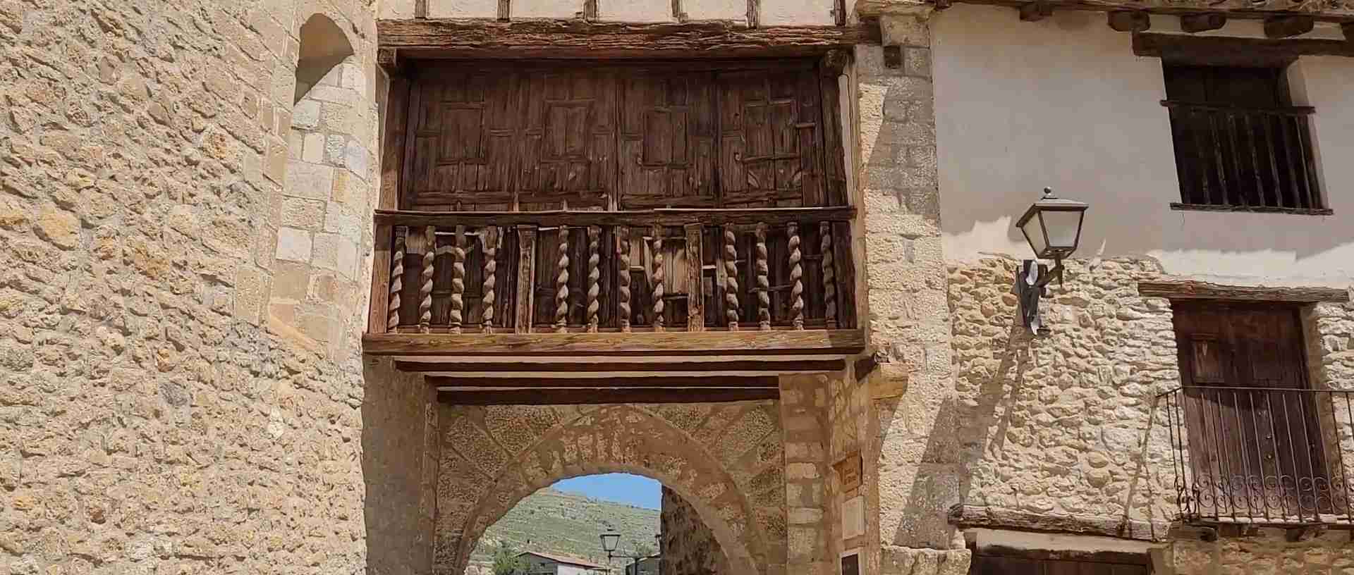
Mirambel’s walls tell a different story of the same principle. The circuit is smaller, corresponding to a lesser settlement, but its state of preservation is arguably even more remarkable: the walls, towers, and gates of Mirambel stand essentially as they were built, the battlements intact, the facing stones in their original courses, the gates retaining their carved ornamental details. The Portal de las Monjas — the Nuns’ Gate — is particularly celebrated, its carved stone lattice work providing a decorative sophistication unusual in a purely defensive context. The completeness of Mirambel’s walled perimeter was the primary criterion for its Europa Nostra Conservation Award, one of the most prestigious heritage conservation honours in Europe.
The gate of La Murada in Villarluengo provides evidence of Templar defensive engineering at the smaller settlement scale, while at Cantavieja, the fragmentary remains of the Templar wall circuit are visible in the lower town, partially incorporated into the fabric of later domestic buildings in the characteristic pattern of medieval military infrastructure that was never demolished but gradually absorbed.
Town Profiles: The Surviving Urban Ensembles of the Maestrazgo
The individual towns of the Maestrazgo repay sustained attention because each represents a distinct accommodation between the shared spatial principles of military order urbanism and the particular geography, history, and institutional character of its specific location. Together they constitute what is arguably the most coherent surviving landscape of medieval frontier urbanism in the Iberian Peninsula.
Morella — The Crown of the Highlands
Morella occupies the definitive position in any account of the Maestrazgo: it is the largest, the most architecturally elaborate, the most symbolically charged, and the most legible expression of what the military order town aspired to be. Situated in the northern interior of Castellón, at the heart of the comarca of Els Ports, it serves as the informal capital of the entire Maestrazgo region in both administrative and symbolic terms. The town has been a member of the association of the Most Beautiful Villages of Spain since 2013 — an honour that, given the competition, is a measure of the exceptional quality of its surviving fabric.
The urban archaeology of Morella is a sequence of civilisations compressed into a single promontory. The rock has been inhabited since prehistoric times, and the town documents occupation by Iberians, Romans, Visigoths, and Moors before the Christian conquest. King Jaume I’s entry into Morella in the thirteenth century initiated the period of maximum urban elaboration: the castle received its Gothic reconstruction, the defensive walls were reinforced and extended, and the Archpriestly Basilica was built over what had presumably been the principal mosque.
The castle complex, perched at the absolute summit of the rock, is a remarkable sequence of courtyards, towers, and residential quarters built across several medieval campaigns and sensitively consolidated in recent decades. The architectural programme of the castle — an aqueduct section, two large cisterns, defensive towers of varying dates, and residential buildings including the Governor’s Palace — communicates the ambition of a fortification that served simultaneously as a military stronghold, a princely residence, and an institutional headquarters for the region. The views from the castle walls across the surrounding highlands, to the mountains of Aragon on one horizon and the beginning of the descent to the Mediterranean on the other, make geographical sense of the castle’s strategic importance in a way that no map fully conveys.
Morella’s connection to the figure of Rodrigo Díaz de Vivar — El Cid — is commemorated in the Camino del Cid heritage route that passes through the town, one section of which is designated the Morella Ring. The historical El Cid operated in the Maestrazgo in the eleventh century, during the complex military politics of the period before the Aragonese consolidation, and his passage through the region is documented sufficiently to make the route historically grounded rather than purely legendary.
The cave paintings of Morella la Vella, located six kilometres from the town in the limestone cliffs above the El Cid valley, add a prehistoric dimension to Morella’s significance that most visitors to the medieval town do not encounter. The paintings, some dating to between 7,200 and 7,400 years ago, were inscribed on the UNESCO World Heritage List as part of the Rock Art of the Mediterranean Arch of the Iberian Peninsula. Among them, a battle scene depicting groups of archers in organised conflict constitutes the earliest known representation of archery combat in the world — a detail that resonates powerfully with the martial geography of the landscape in which it was discovered.
Cantavieja — Templar Stronghold at the Edge of the World
Cantavieja is the most purely Templar town in the Maestrazgo: the one settlement whose entire urban history is inseparable from the order that built it, administered it, and shaped its spatial character across a century of systematic development. Conquered from its Arab defenders in 1197 and immediately assigned to the Templars, the town at 1,200 metres above sea level — on the craggy ridge described so evocatively as an overturned ship’s hull — was the administrative capital of the order’s most important Aragonese encomienda.
The physical evidence of Templar administration is woven through the town’s fabric: the castle site, now largely ruined but visible in its commanding position at the northern tip of the ridge; the original wall circuit, portions of which survive in the lower town, incorporating Templar masonry into the foundations of later domestic buildings; and the spatial organisation of the town itself, which descends from the castle site through a sequence of terraced levels to the principal plaza in a pattern that precisely reflects the functional hierarchy of the Templar encomienda.
The Plaza de Cristo Rey is Cantavieja’s gift to the architectural history of Aragon, an arcaded square of such compositional quality that it appears regularly in discussions of the finest civic spaces in the region. The church of La Asunción, whose unknown architect reportedly claimed that nothing comparable existed in Rome, frames the eastern side of the square with a Levantine Gothic façade of considerable sophistication. Around the plaza and along the main street, the Casa del Bayle and the surviving noble palaces document the prosperity that the Templar encomienda framework generated for the highland merchant and administrative class over the thirteenth and fourteenth centuries.
Cantavieja has a second, very different chapter in its history as the stronghold of Ramón Cabrera Griñó, “the Tiger of El Maestrazgo,” the Carlist general who used the town as a military base during the First Carlist War of the 1830s. The Museum of the Carlist Wars in Cantavieja documents this nineteenth-century chapter, which reactivated the town’s medieval identity as a highland fortress in the service of a cause that, like the Templar administration six centuries before, defined the Maestrazgo as a frontier zone contested between competing power structures. The town’s ancient walls served once again as defensive infrastructure, and the spatial logic of the military order town proved as effective in the age of muskets as it had been in the age of crossbows.
The agricultural landscape around Cantavieja reflects the masía culture of the Aragonese highland: approximately 125 farmsteads — masías, the characteristic isolated farmhouses of the region — are distributed across the municipality, many of them now abandoned or semi-ruined, all of them evidence of the agricultural settlement pattern that the Templar fueros established and that persisted for seven centuries before modern depopulation began to empty the countryside in earnest.
Mirambel — The Most Complete Medieval Ensemble
Mirambel is the town that receives the most superlatives from architectural historians and conservation professionals, and the superlatives are justified. It is the most completely preserved medieval urban ensemble in the Maestrazgo, and possibly in the whole of the Iberian Peninsula: the walls, towers, and principal gates of the medieval circuit stand essentially as built, the internal street plan retains its medieval geometry, and the Gothic civic and noble architecture of the fourteenth and fifteenth centuries survives in a state of conservation that in most European contexts would require sustained and expensive institutional attention. In Mirambel, it is largely a function of benign neglect — the town never grew sufficiently in the post-medieval period to justify demolition and reconstruction.
The town’s history follows the characteristic Maestrazgo trajectory: Alfonso II of Aragon conquered the area in the twelfth century, initially assigning it to the military order of the Holy Redeemer, from whom it passed to the Knights Templar, and after the Templar dissolution to the Order of San Juan del Hospital. This sequence of military order administration left a more varied institutional legacy than the purely Templar towns, and the architectural character of Mirambel reflects the successive interventions of different orders across several generations of construction and modification.
The Portal de las Monjas — the Nuns’ Gate — is the most photographed element of Mirambel’s surviving fabric and justly so. The gate pierces the wall circuit at the eastern edge of the town, its round arch surmounted by a panel of carved stone lattice work of remarkable delicacy: a Gothic tracery pattern applied to a defensive element in a combination that speaks of a society wealthy enough and confident enough to ornament the instruments of its own security. The name commemorates the Augustinian convent that occupied the eastern quarter of the town, one of several religious foundations that developed within the walled circuit during the fourteenth and fifteenth centuries when the initial military imperatives had given way to a more settled urban culture.
Within the walls, the Lonja — the market building — the Renaissance town hall, the church of Santa Margarita, and the series of Gothic noble palaces that line the principal street constitute an ensemble of secular medieval architecture whose coherence and quality are exceptional. The Europa Nostra Conservation Award that Mirambel received is a measure of what the conservation movement recognised: here is a medieval town that has survived not merely as a monument but as a living urban organism, its historic fabric maintained sufficiently to remain habitable and to communicate its history directly and legibly to any visitor who walks its streets.
Mirambel also occupies a curious position in twentieth-century cultural history: its completeness made it an ideal film location, and it has served as the set for several historical productions that required an authentically intact medieval townscape. This use of a living historic town as a film set is a form of recognition that, while occasionally invasive in practical terms, confirms the exceptional quality of survival that distinguishes Mirambel from most comparable European medieval settlements.
Puertomingalvo — The Sentinel of the Sierra
Puertomingalvo occupies the highest point of any significant settlement in the Maestrazgo, its promontory rising to 1,456 metres in the Gúdar-Javalambre massif near the border between Teruel and Castellón. The town is technically outside the comarca of Maestrazgo proper, belonging to the neighbouring comarca of Gúdar-Javalambre, but its historical and typological connections to the military order urbanism of the Maestrazgo are so strong, and its cultural identity so firmly within the same regional tradition, that any account of the Maestrazgo’s urban heritage must include it. It has been a member of the Most Beautiful Villages of Spain since 2013 and its historic centre was declared a Historic-Artistic Site as early as 1982.
The castle of Puertomingalvo, dating primarily to the eleventh century and among the best preserved in the Maestrazgo region, dominates the town from its position at the absolute peak of the promontory. The castle now houses the Interpretation Centre of the Castles of Maestrazgo, placing it in a network of heritage interpretive facilities that spans the region and provides a scholarly framework for understanding the military order landscape as a coherent system rather than a series of isolated monuments. The restored parade ground offers visitors a spatial experience of a medieval castle interior whose layout communicates directly the functional logic of military order fortification.
The Gothic town hall of Puertomingalvo, built between the fourteenth and fifteenth centuries, is one of the finest examples of Levantine Gothic civic architecture in the province of Teruel. The building served simultaneously as town hall, market, and prison — the combination of civic, commercial, and punitive functions in a single building expressing the institutional economy of a small medieval settlement in which space was precious and institutional authority comprehensive. The façade, in worked stone with Gothic windows and loggia, announces the wealth and civic ambition of a community that had, by the fourteenth century, developed well beyond its initial military-order foundations.
The noble palaces of Puertomingalvo — the Casa Lloveros, the Casa Alta, the Casa del Curato — constitute a remarkable ensemble of Levantine Gothic domestic architecture that complements the civic buildings and documents the wealth of the leading families who prospered within the encomienda framework. The Hospital de Santa María de Gracia, founded in the fifteenth century as a refuge for pilgrims and the poor, adds the charitable institutional dimension that completed the social architecture of the medieval highland town: castle, church, civic building, commercial building, hospital — all present, all surviving, all legible.
Villarluengo, Tronchón, La Iglesuela del Cid, and Forcall
The smaller settlements of the Maestrazgo complement the major towns by revealing the range of scales at which military order urbanism operated. Villarluengo, perched at the cliff edge above the Guadalope gorge in a setting described by one commentator as among the most dramatic in Aragon, retains the gate of La Murada as its principal Templar survival. The dramatic natural setting — the gorge of the Guadalope cuts through the limestone massif immediately below the town — gives Villarluengo a geological intensity that is absent from the higher plateau settlements, the river providing both the defensive moat and the primary landscape element of the surrounding territory.
Tronchón’s contribution to cultural history is at once modest and remarkable: its traditional cheese, a soft cylinder with a distinctive hollow centre that allows it to be filled before serving, is cited in Miguel de Cervantes’ Don Quixote, the greatest work of Spanish literature. This minor detail anchors the Maestrazgo in the wider cultural geography of early modern Spain, confirming that the highland economy — cheese-making, wool production, transhumance — was visible and legible enough to appear as a geographical and culinary reference in the literature of the period. The Gothic towers, the town hall, and the church of La Magdalena give Tronchón its architectural character, while the Tremedal shrine documents the intense religious life of a highland community living at the edge of institutional reach.
La Iglesuela del Cid, positioned on the Way of El Cid heritage route, holds the Tower of the Nublos as its principal Templar survival — a defensive tower of the military order period converted over the subsequent centuries into a church bell tower, a transformation that precisely expresses the symbolic transition from military to ecclesiastical authority that occurred across the Maestrazgo as the frontier conditions of the thirteenth century gave way to the more settled urban culture of the fourteenth and fifteenth.
Forcall stands slightly apart from the Templar encomienda circuit in the Valencian Maestrat, but its arcaded plaza, its sequence of Gothic and Renaissance palaces, and the exceptional quality of its stately urban fabric place it firmly within the broader tradition of military order urbanism at its moment of maximum civilian elaboration. The tradition of espadrille-making in Forcall connects the town’s contemporary character to the artisan economy that sustained the highland settlements through the centuries of decline that followed the peak of the medieval wool trade.
The Dissolution of the Templars and the Transition of Authority
The suppression of the Knights Templar, ordered by Pope Clement V and King Philip IV of France in 1307 and formally executed by the Council of Vienne in 1312, had complex consequences in the Crown of Aragon, where the order had been deeply integrated into the highland administration. Unlike in France, where the Templars faced arrest, torture, and execution on charges of heresy and immorality, in Aragon the order’s dissolution was managed with more procedural restraint. The Templar commandants in the Maestrazgo fortified their castles and held out for several years before surrendering to Aragonese royal authority on agreed terms.
The question of what would happen to the Templar properties was resolved differently in the Crown of Aragon than elsewhere in Europe. The Hospitallers — the Order of San Juan del Hospital — were the principal beneficiaries of Templar property transfers across most of Europe, and this was broadly the outcome in the Maestrazgo as well: the encomiendas of Cantavieja and Castellote, the two largest Templar holdings in the region, passed to the Hospitallers, who administered them until the abolition of feudal jurisdiction in Spain in 1813. The management of the highland territory thus continued within the framework of military order administration for another five centuries after the Templar dissolution — an astonishing institutional continuity that ensured the preservation of the urban framework the Templars had established.
Elsewhere in the Crown of Aragon and in the neighbouring Kingdom of Valencia, the Templar dissolution gave rise to a new military order — the Order of Montesa, founded in 1317 by papal bull at the initiative of King Jaume II of Aragon specifically to manage the Templar and Hospitaller properties in the Kingdom of Valencia. The Order of Montesa occupied the castle and town of Montesa in the province of Valencia and exercised authority over a network of commanderies that overlapped with and complemented the Hospitaller administration of the Aragonese Maestrazgo. Its headquarters at Montesa and subsequently at Peñíscola on the Valencian coast provided the institutional framework within which the southern Maestrat, the Valencian half of the historical Maestrazgo, was administered through the late medieval and early modern periods.
The Carlist Wars and the Reactivation of the Frontier
The medieval frontier of the Maestrazgo was reactivated with remarkable literalness in the nineteenth century, when the First Carlist War (1833–1840) and the subsequent Carlist conflicts turned the highland towns once again into fortified positions in a civil war that reproduced, in the age of industrial-era firearms, the tactical logic of the medieval military order landscape. The figure who dominates this chapter is Ramón Cabrera Griñó, a Carlist military commander from Tortosa whose brutal effectiveness in the guerrilla warfare of the highland terrain earned him the epithet “El Tigre del Maestrazgo” — the Tiger of El Maestrazgo.
Cabrera used the medieval highland towns as exactly what the military orders had designed them to be: defensible strongpoints commanding the approaches to the plateau, connected by the network of drove roads and mountain passes that constituted the infrastructure of the region. Morella, appointed by Cabrera as the capital of his Carlist military command covering Valencia, Aragon, and the Maestrazgo, withstood a siege of more than two years before surrendering only after the Isabelline forces bombarded it with over 19,000 projectiles — a detail that speaks both to the effectiveness of the medieval fortifications and to the determination of the forces trying to reduce them. The equestrian statue of Cabrera at the entrance to Morella’s historic centre commemorates this nineteenth-century chapter with the same monumental register that the medieval kings reserved for themselves.
The Museum of the Carlist Wars in Cantavieja provides the dedicated interpretive context for this chapter of the Maestrazgo’s history, documenting the campaigns, the commanders, and the social geography of a conflict that, like the medieval reconquest before it, defined the highlands as a frontier between competing visions of how Spanish society should be organised. The Carlist Wars left physical traces in the landscape — battle sites, fortification reinforcements, destroyed infrastructure — that layer onto the medieval fabric and add a nineteenth-century dimension to the cultural geography of the region.
Rock Art, Prehistory, and the Deep Memory of the Land
Any account of the Maestrazgo that begins with the Reconquista misses a human occupation of the landscape that extends back at least forty millennia. The deep time of the highlands is expressed above all in its rock art, the painted and incised images on limestone surfaces that constitute one of the most significant concentrations of prehistoric art in western Europe and form part of a UNESCO World Heritage Site of trans-regional extent.
The Rock Art of the Mediterranean Arch of the Iberian Peninsula, inscribed on the UNESCO World Heritage List, encompasses a series of sites extending from Catalonia to Andalusia, with the Maestrazgo holding a significant cluster of shelters in both the Aragonese and Valencian sectors. The Maestrazgo Cultural Park records two important Rock Art sites formed by multiple shelters within the World Heritage designation, supplemented by a much larger number of catalogued sites in the broader territory.
The paintings of Morella la Vella command the most attention within this group, and their particular significance lies not only in their age — between 7,200 and 7,400 years before the present — but in the specificity of their content. The scene identified as the oldest known representation of organised archery combat depicts two groups of human figures, each equipped with bows, facing each other across a confrontational space in a composition that reads unmistakably as a battle. That this image should exist in a landscape that would later be organised around the concept of the military frontier, and should be painted on rock surfaces overlooking a valley that medieval armies would traverse in pursuit of the same fundamental territorial contest, is a resonance that gives the concept of the “silent frontier” a genuinely vertiginous depth.
The prehistoric record extends the cultural geography of the Maestrazgo in another direction as well: the region is one of the most important palaeontological sites in the Iberian Peninsula, with over 76 catalogued dinosaur sites contributing to the argument for its designation as a UNESCO Global Geopark. The Galve site, with its dinosaur footprints and life-size reconstructions, and the Castellote site with its Cretaceous petrified trunks, are evidence of a biological occupation of the highlands that precedes the human frontier by hundreds of millions of years, framing the medieval military orders and their towns as the most recent episode in a very long sequence of settlement and movement.
Heritage Conservation and the Question of Depopulation
The Maestrazgo presents heritage conservation with a paradox that is increasingly recognised as one of the defining challenges of rural heritage management in Europe: the outstanding quality of the surviving medieval fabric is inseparable from the process of depopulation that produced it, and the conservation of the one requires addressing the conditions that caused the other. A landscape in which approximately 14,000 people are distributed across 43 municipalities, averaging about two inhabitants per square kilometre, is not merely a landscape of historic monuments; it is a landscape of social fragility that carries historic monuments as a consequence of its fragility.
The Maestrazgo Cultural Park, established as the administrative framework for heritage management across the region’s Aragonese sector, encompasses 43 municipalities within six different comarcas of the Teruel province. Ten historical sites and 21 monuments within the park carry designation as Assets of Cultural Interest (BIC), the highest category of heritage protection in the Spanish national heritage system. Thirteen historical villages have been recognised as National Monuments, a designation that documents the collective rather than individual character of the heritage value at stake in the medieval ensembles.
The European and international conservation community has provided various forms of recognition that translate into political and institutional support for conservation investment. The Europa Nostra award received by Mirambel for the conservation of its walled perimeter is the most prestigious individual site recognition; the UNESCO Global Geopark designation provides a framework for integrated heritage and nature tourism development across the broader territory; and the membership of Cantavieja, Mirambel, and Puertomingalvo in the Most Beautiful Villages of Spain association, with Morella holding equivalent membership on the Valencian side, creates a network of comparative visibility that attracts visitors who would not otherwise penetrate this far into the highland interior.
The challenge of depopulation is not merely demographic but architectural: a heritage fabric that is not lived in deteriorates regardless of its official designation. The Maestrazgo’s medieval buildings survived because they were continuously inhabited and maintained, imperfectly but sufficiently, by the communities that used them. As those communities shrink — the village of Puertomingalvo counted 112 inhabitants at the last count; Mirambel is similarly small — the social infrastructure that sustained the built fabric through routine occupation begins to erode. The rural tourism economy that heritage designations generate provides some economic incentive for continued occupation and careful maintenance, but the scale of the challenge and the depth of the demographic decline make sustainable heritage management one of the most pressing questions facing the Maestrazgo in the twenty-first century.
The region’s own slogan — “El Maestrazgo, donde el silencio habla” (the Maestrazgo, where silence speaks) — acknowledges the depopulation as a cultural condition without resolving it as a political problem. The silence that speaks in the Maestrazgo is the silence of a landscape that was fully inhabited and organised, that generated extraordinary architecture and complex civic culture, and that was subsequently and progressively abandoned by the population whose ancestors built it. Managing that silence — making it productive for heritage tourism without allowing it to become permanent — is the defining institutional challenge of the contemporary Maestrazgo.
Cultural Geography Today: Silence as a Resource
The conceptual framework that the article title proposes — “silent frontiers” — captures something genuine about the contemporary experience of the Maestrazgo that goes beyond the evocative. The frontiers that the military orders constructed were never silent in their own time: they were the sites of military campaigns, legal disputes, commercial transactions, ecclesiastical politics, and the complex social life of towns that functioned as the urban centres of a highland economy producing wool, cheese, iron, and agricultural goods for a wider regional market. The silence is historical — the silence of a world that happened and then retreated from the intensity of the historical moment into a kind of suspended present.
But silence, in the Maestrazgo’s contemporary cultural geography, is increasingly understood as an asset rather than a condition to be remedied. The same near-absence of population that allowed the medieval fabric to survive now creates an environment of exceptional sensory and spatial quality: towns where the stone of the medieval walls is audible underfoot, where the wind across the plateau carries across an absence of mechanical noise, where the night sky above Starlight-certified territories — the comarca of Gúdar-Javalambre has received international recognition for its sky quality — is legible in a way that urban and suburban environments no longer permit.
The geotourism economy that the UNESCO Global Geopark designation supports integrates the geological, archaeological, and architectural heritage of the Maestrazgo into a landscape experience that treats the medieval towns not as isolated monuments but as elements of a continuous cultural geography extending from dinosaur sites to castle towers. Hiking routes connect the principal towns across the highland terrain — the GR-8 long-distance route links Mirambel to Cantavieja, Tronchón, and La Cuba through terrain of consistent scenic quality — while cycling routes exploit the empty roads of the plateau in a form of slow tourism that is structurally well-suited to a landscape whose character depends on moving through it rather than processing it.
The Maestrazgo Cultural Park also carries the designation “destino Starlight” — a certification attesting to the exceptional clarity of its night skies — adding an astronomical dimension to the heritage offer that connects the Maestrazgo’s contemporary cultural geography to its geological past in an unexpected way: the same geological stability that preserved the limestone formations in which the dinosaur fossils are embedded, and kept the human population low enough to prevent the light pollution that obscures the night sky elsewhere, allows the Maestrazgo to offer both palaeontological and astronomical heritage in the same landscape.
What the Maestrazgo offers, finally, is a particular form of temporal experience that is rare in contemporary Europe: the experience of a landscape in which the medieval spatial order is not reconstructed or interpreted but simply present, inhabited at reduced intensity, and available to a careful attention that the silence of the highlands makes possible. The military orders who built these towns in the thirteenth century organised space according to a logic of power, defence, and faith that is entirely foreign to contemporary experience. But the towns they built — their walls, their plazas, their churches, their gates — are still standing, still legible, and still, in their extraordinary silence, speaking.
Frequently Asked Questions
What is the difference between the Aragonese Maestrazgo and the Valencian Maestrat?
The Maestrazgo is a natural and historical region that crosses a modern provincial boundary, with its northern and western portions in the province of Teruel in Aragon (the comarca administratively known as Maestrazgo, Aragon) and its southern and eastern portions in the province of Castellón in the Valencian Community (the comarcas of Alt Maestrat and Baix Maestrat). The Aragonese Maestrazgo, centred on Cantavieja, is where the Templar encomiendas were most extensively developed and where the UNESCO Global Geopark designation applies. The Valencian Maestrat includes Morella, the most architecturally elaborate of the major towns, and Forcall. Despite the modern administrative division, the historical, architectural, and cultural identity of the region is coherent across the boundary, rooted in the same medieval military order administration and expressing itself in the same spatial vocabulary of hilltop towns, arcaded plazas, and Gothic civic architecture.
When were the Knights Templar active in the Maestrazgo, and what happened after their dissolution?
The Knights Templar were active in the Maestrazgo from approximately 1196/1197, when Cantavieja was conquered and assigned to the order, through the Templar dissolution in 1312. This period of roughly 115 years was the formative era of the region’s urban history: the Templars built the castles, issued the population charters, organised the encomienda system, and established the spatial framework of the principal towns. After the dissolution, the Templar properties at Cantavieja and Castellote passed to the Hospitallers (Order of San Juan del Hospital), who administered the territory for a further five centuries until the abolition of feudal jurisdiction in 1813. In the Kingdom of Valencia, the new Order of Montesa, founded in 1317, managed the transition of military order authority in the Valencian Maestrat. The continuity of the military order administrative framework over this extended period is one of the reasons the urban fabric created in the Templar period was maintained rather than transformed.
Which Maestrazgo towns are members of the Most Beautiful Villages of Spain?
Four towns associated with the Maestrazgo hold membership in the association of Los Pueblos Más Bonitos de España (The Most Beautiful Villages of Spain): Cantavieja, Mirambel, and Puertomingalvo in the Aragonese Maestrazgo and Teruel region, and Morella in the Valencian Maestrat. Morella was admitted to the association in 2013. This collective recognition across all four principal medieval urban ensembles of the region is a measure of the exceptional and consistent quality of surviving medieval fabric that distinguishes the Maestrazgo from comparable highland zones in Spain, where post-medieval development has consistently obscured or replaced the medieval layers in the most accessible and commercially successful settlements.
What is the Maestrazgo Cultural Park and what does it protect?
The Maestrazgo Cultural Park is a heritage and nature conservation administrative unit covering 43 municipalities across six comarcas in the province of Teruel. It holds designation as a UNESCO Global Geopark, recognising its exceptional geological and palaeontological heritage alongside its cultural assets. Within the park’s territory are 10 historical sites, 21 monuments, and one archaeological zone carrying BIC (Asset of Cultural Interest) designation under Spanish national heritage law, as well as two rock art sites forming part of the UNESCO World Heritage Site for the Rock Art of the Mediterranean Arch of the Iberian Peninsula. Some 615 archaeological sites have been catalogued within the park, and 40 per cent of its territory has been designated a Site of Community Interest for its natural heritage values. Thirteen historical villages within or associated with the park have been recognised as National Monuments for the collective quality of their medieval urban fabric.
How did the population charters issued by the Templars shape the urban form of the Maestrazgo towns?
The population charters — fueros or cartas de población — issued by the Templars and other military orders in the late twelfth and thirteenth centuries were instruments of deliberate colonisation that shaped both the social organisation and the physical form of the highland settlements. By specifying the rights attached to particular plots, defining the civic institutions that settlers were entitled to establish, and granting market and fair rights that created the economic rationale for permanent urban settlement, the charters generated the social infrastructure around which the towns’ physical fabric developed over subsequent generations. The arcaded plazas that are among the most visible surviving features of Cantavieja, Morella, and Forcall are the spatial realisation of the market rights encoded in the charters, translated into stone and arcade over the generations that followed the initial grants. The fuero system also established the legal framework for the Gothic civic buildings — town halls, noble palaces, loggias — that proliferated in the fourteenth and fifteenth centuries as the military order foundations matured into genuinely urban communities.
What is the significance of the cave paintings at Morella la Vella?
The rock art shelters at Morella la Vella, located approximately six kilometres from the medieval town of Morella in the limestone cliffs of the Els Ports landscape, are included within the UNESCO World Heritage Site for the Rock Art of the Mediterranean Arch of the Iberian Peninsula. Dated to between 7,200 and 7,400 years ago, the paintings are notable both for their quality and for the specificity of their subject matter. Among the images is a battle scene depicting two groups of human figures equipped with bows, firing at each other in a composition identified by researchers as the oldest known representation of organised archery combat in the world. This prehistoric scene of organised human conflict in the same landscape later associated with frontier warfare and military order administration gives the Maestrazgo’s identity as a contested frontier zone a depth extending millennia beyond the medieval period.
What does the Tronchón cheese connection to Don Quixote tell us about the Maestrazgo economy?
Tronchón cheese, the soft highland cylinder with a distinctive hollow centre produced in the village of Tronchón in the Aragonese Maestrazgo, is cited by Miguel de Cervantes in Don Quixote — the reference documenting the cheese’s visibility and reputation in the early seventeenth century across a readership that extended far beyond the highland interior. The detail is not trivial: it confirms that the Maestrazgo’s pastoral economy — the production of cheese and wool through the transhumant livestock system that had been the economic backbone of the region since the medieval military orders organised the territory — was sufficiently well known to serve as a geographical and culinary reference in the most widely read work of Spanish literature. The cheese has been produced continuously to this day, making it one of the longest-documented food products in Spain and a living connection between the contemporary highland economy and the transhumant system that the Templar population charters helped establish.
Why is Mirambel considered exceptionally important for heritage conservation?
Mirambel’s importance in heritage conservation terms rests on the exceptional completeness and integrity of its surviving medieval urban fabric. The walled perimeter, including all principal towers and gates, stands essentially as built, without significant modern intrusion into the circuit. The Portal de las Monjas retains its carved stone lattice in its original position. The internal street plan maintains its medieval geometry. The Gothic civic and noble architecture of the fourteenth and fifteenth centuries survives in a density and state of preservation rare at this scale in any European context. The Europa Nostra Conservation Award — one of the most prestigious heritage honours in Europe — was granted specifically in recognition of this comprehensive survival, which in most comparable European towns was prevented by the pressures of post-medieval commercial and residential development. In Mirambel, those pressures never materialised at sufficient scale, and the medieval layers were maintained through continuous but modest occupation over seven centuries rather than through deliberate preservation investment.
What is the role of the Maestrazgo’s geological heritage in its UNESCO recognition?
The Maestrazgo Cultural Park UNESCO Global Geopark was designated on the basis of its exceptional geological and palaeontological heritage, which encompasses a remarkably complete record of Mesozoic geological processes visible in the exposed rock formations of the Guadalope valley and its tributaries. Over 76 catalogued palaeontological sites document the dinosaur fauna of the Late Jurassic and Early Cretaceous periods, when the area alternated between marine and terrestrial environments supporting diverse biological communities. The Crystal Caves of Molinos, the petrified trunk forests near Castellote, and the organ-pipe rock formations of the Órganos de Montoro near Villarluengo are prominent geological features that provide a scenic and educational dimension to the geopark beyond the strictly palaeontological. The Rock Art sites within the Geopark territory, combined with the medieval urban heritage, allow the geopark framework to integrate heritage interpretation across a time range extending from the Cretaceous to the nineteenth century — an unusual breadth that gives the Maestrazgo Geopark a distinctive educational character among European UNESCO Geoparks.
How do visitors experience the Maestrazgo today, and what routes connect the principal towns?
The Maestrazgo requires a commitment to movement that rewards patience: the towns are distributed across a territory of considerable extent, connected by mountain roads that are in good condition but slow, and the most significant sites are not accessible by public transport at any meaningful frequency. Most visitors explore the region by private vehicle over two or more days, using one of the principal towns — most often Cantavieja or Morella — as a base for day excursions. The GR-8 long-distance hiking route connects Mirambel to Cantavieja, Tronchón, La Cuba, and other highland settlements through terrain of consistent scenic quality, making it the most immersive route for visitors whose primary interest is landscape experience integrated with cultural heritage. Cycling routes exploit the empty plateau roads and are particularly well-suited to the character of a landscape whose silences and long views are best appreciated at speeds low enough to hear the wind. The cultural route “Templarios por el Maestrazgo” (Templars through the Maestrazgo) provides a more specifically themed heritage itinerary connecting the principal sites of military order history across the region, including the Templar Interpretation Centre at Castellote castle, the urban ensembles of Cantavieja and Mirambel, and the rock art sites associated with the Morella la Vella paintings.