The Landscapes of Thessaly: Where Dramatic Nature Meets Greece Sacred History
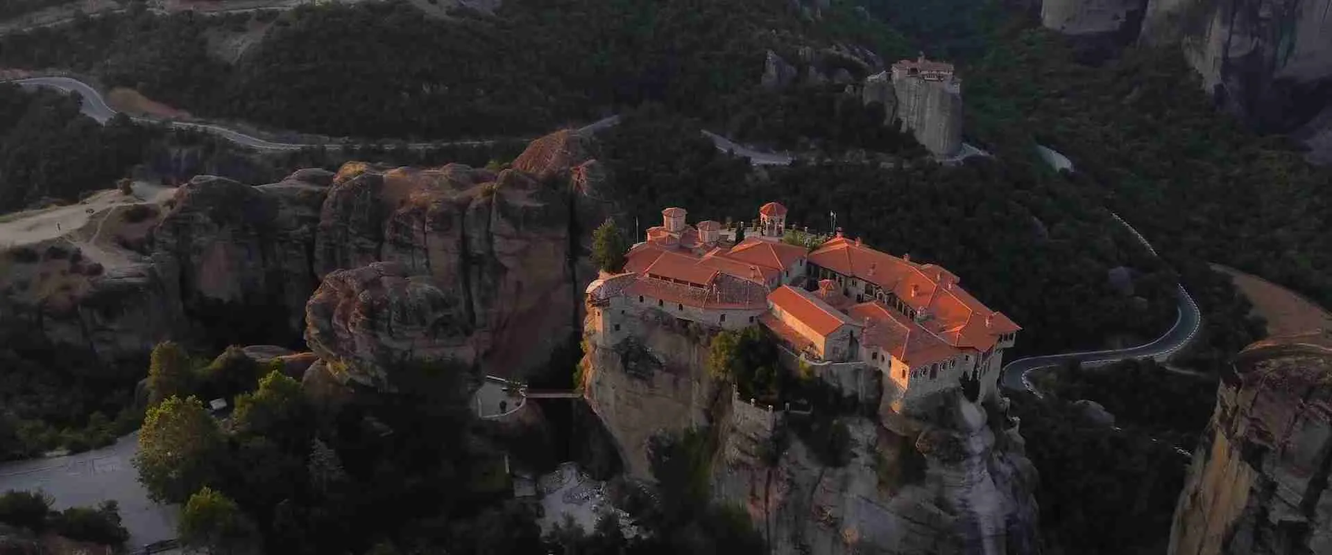
Thessaly rises from the Aegean toward the mythological heights of Olympus, a central Greek region where mountain walls enclose the country’s largest plain and sandstone pinnacles lift Byzantine monasteries hundreds of meters above the earth. Homeland of Jason and the Argonauts, ancient battleground where Rome mastered Macedon and Caesar defeated Pompey, and location of one of the world’s great intersections of geological spectacle and Orthodox heritage, Thessaly holds a singular place in European geography and mythology. This guide charts the complete landscape — from Meteora’s UNESCO-inscribed formations to the mythological harbor of ancient Iolcos, from the sacred gorge of the Vale of Tempi to the wild Agrafa wilderness.
Key Takeaways
- Mixed UNESCO Heritage: Meteora earned its 1988 UNESCO World Heritage designation under both cultural and natural criteria — a dual distinction held by fewer than 40 sites globally, placing it alongside Machu Picchu and Stonehenge as one of the world’s most comprehensively protected cultural-natural landscapes.
- Six Living Monasteries: Six monasteries remain active on Meteora’s sandstone pinnacles — Great Meteoron, Varlaam, Roussanou, St. Nicholas Anapafsas, Holy Trinity, and St. Stephen — survivors of the 24 original foundations built between the 14th and 16th centuries.
- Greece’s Largest Plain: The Thessalian plain is the largest lowland in Greece, enclosed by five mountain ranges — Pindus, Olympus-Kamvounia, Ossa, Pelion, and Othrys — and drained by the Pineios River, which exits through the narrow Vale of Tempi into the Aegean Sea.
- The Mythological Homeland: Thessaly is the setting for three foundational Greek myths: Olympus as the residence of the twelve gods, Pelion as the home of the Centaurs and the education ground of Jason and Achilles, and ancient Iolcos as the departure harbor of the Argonauts.
- Greece’s First National Park: Olympus National Park, established on 9 June 1938, is the oldest national park in Greece, protecting the flanks of the country’s highest summit — Mytikas at 2,917 meters — with ecological zones spanning Mediterranean scrubland to alpine scree.
- The Unwritten Mountains: The Agrafa range — its name meaning “unwritten” from its deliberate absence on Ottoman tax registers — shelters one of Greece’s most isolated traditional landscapes, anchored by the artificial Lake Plastiras at 770–780 meters altitude in the southern Pindus.
People Also Ask About the Landscapes and Sacred Heritage of Thessaly
What makes Meteora a UNESCO World Heritage Site?
Meteora received its UNESCO World Heritage inscription in 1988 under a dual designation — one of fewer than 40 mixed (cultural and natural) inscriptions worldwide. The cultural criteria recognize Meteora as a unique artistic achievement for constructing functioning monasteries on near-vertical rock pinnacles, as an outstanding example of 14th- and 15th-century Byzantine architecture adapted for meditation and prayer, and as evidence of the monastic response to political instability during the decline of the Byzantine Empire. Criterion V also acknowledges the vulnerability of this traditional settlement pattern, reduced from 24 active monasteries to 6. The natural criterion recognizes the exceptional beauty and geological significance of the sandstone formations — rare conglomerate pillars shaped by approximately 60 million years of tectonic movement and erosion. The site additionally forms part of the Natura 2000 European protected area network, recognizing its botanical and zoological values.
What mythological stories are set in Thessaly?
Thessaly is the mythological setting for some of the most consequential narratives in Greek religion and literature. Mount Olympus, on its northern border, is the residence of Zeus and the twelve Olympian gods. The Pelion Peninsula is the home of Chiron the centaur, who educated Jason, Achilles, and Asclepius. Ancient Iolcos — at the site of modern Volos — is the harbor from which Jason and the Argonauts launched their voyage to retrieve the Golden Fleece from distant Colchis. The Vale of Tempi is sacred to Apollo, who purified himself there after slaying Python at Delphi and cut the first laurel branches that became his sacred plant. In the gigantomachy myths, the giants Otus and Ephialtes stacked Mount Pelion onto Mount Ossa in their attempt to scale Olympus and overthrow Zeus — a narrative that gives the region’s mountain landscape cosmic significance.
What are the main geographic features of Thessaly, Greece?
Thessaly forms a natural geographic amphitheater enclosed by five mountain ranges. The Pindus range defines the western border with Epirus. The Kamvounia-Olympus massif stands to the north. Mount Ossa (also called Kissavos, 1,978 meters) and the Pelion range rise to the northeast and east, with the Pagasitic Gulf opening between Pelion and the mainland. Mount Othrys closes the southern edge. Within this enclosure, the Pineios River and its tributaries drain the Thessalian plain — the largest in Greece — before cutting through the Vale of Tempi gorge into the Aegean. The region covers 14,036 square kilometers and encompasses four prefectures: Larissa, Trikala, Karditsa, and Magnesia. It also includes the Magnesia Peninsula (the Pelion mountain and its coastline) and the Agrafa mountain mass of the southwest.
How many monasteries are currently active at Meteora?
Six monasteries are currently active at Meteora: the Great Meteoron, Varlaam, Roussanou, St. Nicholas Anapafsas, Holy Trinity, and St. Stephen. These six survive from 24 original foundations built mainly between the 14th and 16th centuries. Four — Great Meteoron, Varlaam, St. Nicholas Anapafsas, and Holy Trinity — are managed by monks; Roussanou and St. Stephen function as convents staffed by nuns. St. Stephen, the most accessible of the six, has operated as a convent since 1961 and houses the largest monastic community at Meteora. Of the 18 monasteries that no longer operate, some survive as ruins accessible on the rock formations, while others have largely disappeared from the record. All six active monasteries are open to visitors under dress-code requirements — shoulders and knees covered — that reflect their status as living places of worship.
Extended multi-day tours – 5+ days
Featured Northern Greece Multi-Day Tour Packages
8 days
Walking the Corfu Trail (North)
- ✓ Comprehensive Northern Greece tour
- ✓ Expert local guides included
- ✓ All accommodation arranged
- ✓ Transportation provided
7 days
Hiking Zagori & Meteora
- ✓ Comprehensive Northern Greece tour
- ✓ Expert local guides included
- ✓ All accommodation arranged
- ✓ Transportation provided
8 days
Walking the Corfu Trail (South)
- ✓ Comprehensive Northern Greece tour
- ✓ Expert local guides included
- ✓ All accommodation arranged
- ✓ Transportation provided

8 days
Warm Valley Trail – Spin & Stride Through Valia Calda & Zagori
- ✓ Comprehensive Northern Greece tour
- ✓ Expert local guides included
- ✓ All accommodation arranged
- ✓ Transportation provided
Multi-day tour packages powered by TourRadar. Prices and availability subject to change.
Thessaly: The Natural Amphitheater at the Heart of Greece
Thessaly occupies a unique position in the geography and imagination of Greece. Bounded by five mountain ranges that form a near-complete enclosure, the region shelters the largest inland plain in the country — a flat agricultural basin surrounded by dramatic upland terrain that has shaped human settlement, mythology, and military history for more than five millennia. The Pineios River, known in antiquity as the Peneus, runs through the entire breadth of the plain and exits through the narrow Vale of Tempi into the Aegean Sea — a geological arrangement so remarkable that the ancient Greek historian Herodotus attributed it to divine intervention, suggesting that Poseidon had split the mountains with a great earthquake to drain what had once been a vast inland lake.
The geographic logic of Thessaly is one of containment and release. The mountains form the container: the Pindus to the west (the “spine of Greece”), Mount Olympus and the Kamvounia range to the north, Mount Ossa (Kissavos) and the Pelion range to the northeast and east, and Mount Othrys to the south. Within this container, the Thessalian plain extends as the largest continuous lowland in Greece — an agricultural heartland renowned since antiquity for its grain production, horse breeding, and the military power that both resources supported. The Thessalian cavalry was the most formidable in the classical Greek world, and the breeding grounds of the Thessalian plain supplied the warhorses that gave Philip II of Macedon and later the Roman generals their tactical advantages over infantry-dependent armies.
The region covers 14,036 square kilometers across four prefectures: Larissa in the northeast (the regional capital), Trikala in the northwest (the gateway to Meteora), Karditsa in the southwest, and Magnesia in the southeast. Each prefecture presents a distinct landscape — the flat grain fields of Larissa, the mountain foothills and dramatic rock formations of Trikala, the mountain lakes and Agrafa wilderness of Karditsa, and the forested Aegean-facing peninsula of Magnesia.
What makes Thessaly extraordinary beyond its physical geography is the density of mythological, ancient, Byzantine, and natural heritage concentrated within its mountain walls. No other region in Greece holds simultaneously: a UNESCO World Heritage Site of global significance, the home mountain of the Greek gods, a peninsula embedded in the Argonaut mythology, the sites of battles that shaped the Western world, and a wilderness area that Ottoman tax collectors never successfully mapped. Thessaly is not a single destination but an entire world of layered landscapes, each stratum representing a different chapter in the human relationship with extraordinary terrain.
The Meteora Rock Formations: An Ancient Geological Drama
The sandstone pillars of Meteora are the most visually arresting geological feature in Greece, rising abruptly from the flat Thessalian plain at the foot of the Pindus range to heights exceeding 400 meters. Their formation story spans tens of millions of years and involves an ancient sea, a vanishing delta, tectonic upheaval, and millions of years of erosion — processes that together produced rock columns without parallel in the Mediterranean world.
The geological foundation of Meteora is a series of conglomerate and sandstone beds belonging to the Pentalofos-Meteora Formation, a deposit of Late Oligocene to Early Miocene age. Hundreds of millions of years before the present landscape existed, a shallow sea covered the region. Rivers flowing into this sea from the surrounding mountains deposited enormous quantities of stone, sand, and mud into a deltaic formation. This sediment compacted over time into the conglomerate that now defines the pillars — a mixture of rounded river pebbles cemented in a sandstone matrix, notably different from the hard igneous rock of typical volcanic plug formations found elsewhere in the world.
Approximately 60 million years ago, during the Paleogene period, tectonic forces pushed the seabed upward, creating a high plateau and introducing numerous vertical fault lines through the thick sandstone layers. These faults became the pathways for millions of years of subsequent weathering. Water infiltrated the cracks. Extreme temperature fluctuations — hot summers and frozen winters — expanded and contracted the rock. Wind eroded the exposed surfaces. Over geological time, softer material was stripped away while more resistant sections survived, producing the isolated pillars and clustered formations visible today.
The result is a landscape of approximately 60 rock formations covering more than seven square kilometers. Individual pillars reach heights of up to 313 meters above their bases. The monastery of Roussanou sits at 415 meters above the Pineios valley floor, and the tallest point in the complex — the Agia rock — stands at 630 meters above sea level. These formations are unusual in their vertical uniformity: the conglomerate was deposited without the distinct vertical layering common in other sedimentary sequences, a characteristic that gives the pillars their distinctive, almost architecturally regular appearance and makes them structurally coherent despite their extreme verticality.
The German geologist Alexander Phillipson, who conducted pioneering research in the Meteora region in the late 19th century, proposed the most widely accepted theory for the formations’ origin. He argued that a deltaic cone of river material was progressively lifted and then sculpted by erosion as the regional waterways drained toward the Aegean — explaining why the surrounding softer rock of the Thessalian basin eroded far more rapidly than the harder conglomerate, leaving the pillars standing as isolated erosional remnants above the plain. Modern geological research places the formations within the broader Meso-Hellenic Trough — a geological depression that collected sediment from the emerging Alpine ridge of the Pindus Mountains across many millions of years. Meteora represents not merely a visual spectacle but one of the most scientifically significant geological monuments in Greece: a record of Paleogene and Neogene sedimentation and Alpine tectonics preserved in extraordinary three-dimensional form.
The Monasteries of Meteora: Sacred Architecture on the Pinnacles
The decision to build monasteries on the summits of Meteora’s sandstone pillars represents one of the most remarkable acts of human determination and spiritual commitment in Byzantine history. What began as a refuge for individual hermits in the 10th and 11th centuries evolved, across two centuries of construction, into the greatest concentration of mountaintop religious architecture in the world.
The earliest religious communities at Meteora date to approximately the 10th century, when small groups of ascetic monks moved into the caves and crevices at the base of the pillars, seeking isolation from the turbulence of the late Byzantine world. In the late 12th century, a small church called the Panaghia Doupiani — or Skete — was built at the foot of one of the columns, forming the nucleus around which the hermitic community would develop. The monks who settled here were drawn by exactly the qualities that made the formations so inhospitable: their inaccessibility, their silence, and their visual separation from the secular world below.
The decisive moment in Meteora’s monastic history came in the 14th century, when the monk Athanasios — later canonized as Saint Athanasios the Meteorite — ascended the highest pinnacle and founded the Great Meteoron monastery, dedicated to the Transfiguration of Christ, around 1340 to 1344. Athanasios arrived from Mount Athos, bringing with him the liturgical and architectural traditions of that sacred peninsula, and established the organizational model — the Athonite typikon — that would govern all subsequent Meteora foundations. His achievement in establishing a functioning monastic community on the summit of a massive rock pillar, accessible only by rope nets and retractable ladders, represented a theological statement as much as an architectural one: the monks were, quite literally, suspended between earth and heaven.
The great period of construction that followed — spanning the late 14th and entire 15th centuries — coincided with the collapse of Byzantine political power and the advance of Ottoman rule. Thessaly came under Serbian control under Simeon Uroš in the 1340s and 1350s, then passed to his son John Uroš, who later abdicated to become the monk Ioasaph and retired to Meteora, contributing substantially to the endowment of the Great Meteoron. The political instability of the region gave the mountain monasteries an urgent practical function beyond spiritual retreat: they served as places of safety, repositories of church treasures, manuscripts, and cultural memory at a time when these were threatened by the political transformations engulfing the Byzantine world.
Twenty-four monasteries were eventually established across the formation complex. At their 16th-century peak, these supported substantial monastic communities and accumulated important collections of Byzantine art, portable icons, illuminated manuscripts, embroidered textiles, and liturgical objects. Access was achieved exclusively through rope nets and baskets hauled up the rock faces — a system that maintained the separation of the monastic world from the outside while also serving as one of the most extreme solutions to a logistical challenge in European architectural history. Visitors to some monasteries were still being winched up by net in the early decades of the 20th century.
Of the 24 original foundations, six monasteries survive in active use. The Great Meteoron (Holy Monastery of the Transfiguration of Christ) is the oldest and largest of the six, occupying the highest and most massive rock in the complex. Founded by Athanasios around 1344 and developed under the patronage of the Serbian royal monk Ioasaph, its principal church — a three-aisled basilica completed in the 16th century — contains frescoes of considerable historical importance, and a small museum holds an exceptional collection of Byzantine manuscripts, carved wooden iconostases, and liturgical metalwork.
Varlaam is the second largest monastery, built in the 16th century on a site previously occupied by the hermit Varlaam in the 14th century. Its principal church, the All Saints katholikon, was completed in 1542 and decorated in 1548 with frescoes by the Theban painter Franco Katelano, whose work is notable for its narrative detail and realistic representation of historical events within Byzantine iconographic tradition.
St. Nicholas Anapafsas is the smallest of the six monasteries, dating to the late 14th century and perched on a relatively modest pillar at the entrance to the Meteora road from Kastraki. Its particular art-historical significance is the fresco cycle by Theophanes Strelitzas — Theophanes the Cretan — completed in 1527, depicting the Passion of Christ, the Virgin in prayer, and scenes from monastic life in the developed Cretan school tradition.
Roussanou is a 16th-century foundation built on a dramatically exposed pillar between Varlaam and St. Nicholas Anapafsas, now functioning as a convent dedicated to St. Barbara. It is approached by a stone bridge over a vertiginous gap and is notable for its Early Modern murals, including representations of the Apocalypse. Holy Trinity, with documentary evidence dating to 1362, stands on an isolated pillar at the southern end of the complex, approached by approximately 140 steps cut into the rock; its cruciform church with two-columned central dome was completed in 1476. St. Stephen is the most accessible of the six, reached by a flat stone bridge and operating as a convent since 1961, housed above the city of Kalambaka with the largest resident monastic community in the complex.
Meteora as UNESCO World Heritage: Cultural and Natural Recognition
The 1988 inscription of Meteora on the UNESCO World Heritage List represents one of the relatively rare instances in which a site receives recognition for both its cultural and natural significance simultaneously. Of the more than 1,100 properties on the World Heritage List, fewer than 40 carry this dual designation — a category reserved for sites where the interaction between human achievement and natural setting is considered mutually inseparable and of universal outstanding value.
The cultural criteria under which Meteora is inscribed are specific and exacting. Criterion I recognizes the site as a unique artistic achievement — the architectural transformation of an extreme natural setting into a place of retreat, meditation, and prayer, an achievement without parallel in Christian monastic history. Criterion II acknowledges the significant influence of Meteora’s monastic tradition on the development of post-Byzantine religious architecture and iconography, particularly the Cretan school of painting that shaped Orthodox visual culture across Greece and the Balkans. Criterion IV identifies Meteora as an outstanding example of a type of construction illustrating a significant period in human history — specifically the monastic response to political instability during the decline of the Byzantine Empire and the period of Ottoman advance. Criterion V recognizes the ensemble as an example of a traditional human settlement and land use rendered vulnerable by irreversible change, noting the dramatic reduction from 24 active monasteries to 6 and the ongoing pressures of mass tourism on a living religious community.
The natural criterion — Criterion VII — recognizes the site for its exceptional natural beauty and the aesthetic importance of the rock formations. The vertical sandstone pillars rising above the Thessalian plain represent a landscape of extraordinary visual power, and the combination of geological spectacle with the human architecture perched atop it constitutes an integrated natural-cultural composition of universal significance. This category of inscription — mixed cultural-natural — places Meteora in the company of Yellowstone, the Galapagos, and the Dolomites as landscapes where natural and human values are inseparably intertwined.
The protected area of the Meteora World Heritage Site covers 271.9 hectares, with a buffer zone of 1,884.1 hectares surrounding the core formation complex. The site forms part of the Natura 2000 protected area network (GR1440003), which recognizes its botanical and zoological values alongside its cultural significance. The rock formations support endemic and endangered plant species adapted to the bare sandstone surfaces, while the vertical rock faces provide nesting habitat for raptors including the Egyptian vulture, peregrine falcon, and common kestrel. The UNESCO Conservation Outlook Assessment of December 2020 rated the site’s overall conservation status as “good with some concerns,” identifying tourism pressure — more than two million visitors annually — as the primary management challenge, generating overcrowding, traffic congestion, and trail erosion that require sustained active intervention.
The Byzantine Art of Meteora: Frescoes, Icons, and the Post-Byzantine Tradition
Meteora’s monasteries function not only as places of active religious life but as repositories of one of the most coherent collections of post-Byzantine art surviving in continental Greece. The frescoes, portable icons, manuscripts, and liturgical objects housed within the six active monasteries document a continuous tradition of Orthodox artistic production spanning the 14th through the 18th centuries, tracing the development from late Palaeologan Byzantine style through the high Cretan school and into the ecclesiastical Baroque.
The foundational art-historical significance of Meteora lies in its connection to the Cretan school of post-Byzantine painting — the artistic tradition that developed following the fall of Constantinople in 1453 and became the dominant visual language of Orthodox Christianity across the Mediterranean world. The school integrated the iconographic conventions of Byzantine art with selected elements of Italian Renaissance naturalism, producing a distinctive style characterized by strong draftsmanship, refined color, and increasingly sophisticated representation of human emotion and narrative drama.
The most important expression of this tradition at Meteora is the fresco cycle by Theophanes Strelitzas — known as Theophanes the Cretan — at St. Nicholas Anapafsas, completed in 1527. Theophanes is considered the preeminent master of the Cretan school, and his Meteora commission represents one of his earliest known campaigns before his more celebrated later work on Mount Athos, at the monasteries of Lavra and Stavronikita. The Meteora frescoes depict the Passion cycle, scenes from the lives of the desert fathers, and the protecting figures of saints, rendered with a restrained emotional intensity that marks the highest achievements of the tradition. Working on the confined and irregular surfaces of the small St. Nicholas Anapafsas church, Theophanes arranged multiple narrative scenes with compositional skill that produces visual coherence from every angle in a space where standard Byzantine compositional schemes required substantial adaptation.
At Varlaam, the frescoes by the Theban painter Franco Katelano, completed in 1548, represent a different but equally significant strain of post-Byzantine painting. Katelano’s work is distinguished by its narrative ambition and by the integration of Byzantine compositional hierarchies with the more descriptive and dramatic approach that characterizes the western Greek (Epirote) painting tradition. The Varlaam frescoes include an extended cycle of the Apocalypse of St. John — a subject of considerable theological resonance in the mid-16th-century Orthodox world, where the recent fall of Constantinople and continuing Ottoman advance gave the imagery of divine judgment immediate contemporary force.
The portable icons held within the monastery collections include works spanning from the 14th through the 18th centuries. The Great Meteoron museum houses 14th-century icons in the late Palaeologan style — the refined courtly aesthetic of the last Byzantine dynasty — alongside illuminated manuscripts with exceptional miniature cycles and carved wooden iconostases displaying the craft of Epirote woodcarvers working in a tradition of great technical refinement. The liturgical metalwork — chalices, censers, reliquary caskets, and bound Gospel covers in silver and gilt — documents the patronage network that sustained the monasteries across five centuries: Serbian rulers, Byzantine nobility, local Thessalian landowners, and later Ottoman-period merchants all contributed to the accumulation of these objects, ensuring the preservation of the physical infrastructure of Orthodox worship through repeated changes in political authority over Thessaly.
The Thessalian Plain: Cradle of Ancient Power
The Thessalian plain — the largest lowland in Greece — was the agricultural and military heartland of the Greek world for more than three millennia. Enclosed by its mountain walls and drained by the Pineios River, the plain supported some of the earliest sedentary communities in the Aegean world, and the power that agricultural surplus and horse-breeding capacity gave Thessaly’s ruling families shaped the political history of Greece from the Bronze Age through the Roman conquest.
Human settlement of the Thessalian plain began in the Neolithic period. The site of Sesklo, just outside modern Volos, is one of the oldest known organized settlements in Europe, with occupation layers spanning from approximately the 7th millennium BC to around 2500 BC. The settlement included permanent stone architecture, evidence of planned urban layout, and pottery of high technical quality — indicators of a sophisticated agricultural society considerably older than the Mycenaean civilization that would later dominate Aegean Bronze Age culture. The nearby site of Dimini, also in Thessaly, provides evidence of a subsequent Neolithic settlement phase characterized by distinctive spiral-decorated ceramics and a more elaborate fortified layout.
The Bronze Age in Thessaly is marked primarily by the legendary city of Iolcos, identified by archaeologists with the settlement beneath and around modern Volos. The palace at Iolcos is attested in the ancient sources as the home of Jason, the departure point of the Argonauts, and a center of Mycenaean power in the northern Aegean. Archaeological investigations in the Volos area have revealed Bronze Age and Mycenaean deposits consistent with a significant palatial center, though the exact extent and administrative character of ancient Iolcos remains a subject of ongoing scholarly investigation. The city’s position at the head of the Pagasitic Gulf — the sheltered inland sea enclosed between the Pelion Peninsula and the Thessalian mainland — made it the natural gateway for Mycenaean maritime trade into the northeastern Aegean and the Black Sea beyond.
In the historical period, the most powerful families of Thessaly organized themselves into the Thessalian League, centered on Larissa as the political capital and oriented primarily around the exploitation of the plain’s military resource: cavalry. The Thessalian horse-lords were sought as allies by every major power in the classical world. Philip II of Macedon, whose campaigns transformed the Greek world in the 4th century BC, achieved decisive victories in Thessaly — most notably the Battle of the Crocus Field in 353 BC, where he defeated the Phocian mercenary army near Pagasai, established Macedonian dominance over central Greece, and was elected archon of the Thessalian League. This gave Philip legal control of the formidable Thessalian cavalry that would later support Alexander the Great’s Asian campaigns as the elite shock force of the Macedonian army.
Thessaly served thereafter as the arena for two later battles of world-historical significance. At Cynoscephalae in 197 BC, the Roman general Titus Quinctius Flamininus defeated Philip V of Macedon in an engagement that ended Macedonian military power in the Greek world and established Roman supremacy in the eastern Mediterranean. At Pharsalus in 48 BC, Julius Caesar defeated Pompey to resolve the Roman civil war — a battle fought on Thessalian soil that determined the institutional future of the Roman world. The plain that had produced the mythological Centaurs and the historical cavalry of the Thessalian League had become, by the 1st century BC, the stage on which the fate of the Western world was decided.
Mount Olympus and the Vale of Tempi: Sacred Passages of the North
Mount Olympus stands on the border between Thessaly and Macedonia, rising to 2,917 meters at its Mytikas summit — the highest point in Greece. The mountain has been sacred in the Greek imagination since the earliest recorded mythological texts: Olympus is the residence of Zeus and the twelve Olympian gods, the site of divine council and feast, the mountain from which Zeus hurls his thunderbolts and Hermes begins his flights as messenger. No other geographic feature in European mythology carries the same intensity of divine association.
The physical character of Olympus fully justifies its mythological status. The mountain rises with extraordinary abruptness from the coastal plain, presenting a vertical ascent of more than 2,000 meters over a horizontal distance of only a few kilometers. The upper zones are perpetually snow-covered in winter and capped by cloud in summer — conditions that reinforced, in antiquity, the sense of a divine realm above the clouds and beyond mortal reach. The nine Muses, the divine patronesses of the arts and sciences, inhabited Olympus and the related peaks of Pieria to the north, a mythological geography that linked Thessaly to the origins of human cultural achievement and to the divine inspiration that was considered the prerequisite for all forms of artistic production.
Olympus National Park, established on 9 June 1938, was the first national park created in Greece. It protects 39.88 square kilometers on the mountain’s southern and southeastern flanks, encompassing an exceptional range of ecological zones: Mediterranean scrubland at lower elevations, deciduous forest in the middle zones, coniferous forest dominated by black pine above 1,500 meters, alpine meadow with rich endemic flora, and bare scree approaching the summit. The mountain’s ecological diversity reflects its position as a meeting point between the Mediterranean south and the continental north, producing a flora with strong concentrations of endemic and rare species found nowhere else in Greece.
The Vale of Tempi — the gorge through which the Pineios River exits Thessaly for the Aegean — is one of the most sacred landscapes in ancient Greece and one of the most strategically important in the military history of the ancient world. The vale runs for approximately 10 kilometers between Mount Olympus to the north and Mount Ossa (Kissavos) to the south, narrowing in places to as little as 25 meters, with cliffs rising nearly 500 meters on each side. Through this single narrow passage — in antiquity, the only practical lowland route between Thessaly and Macedonia — all armies, travelers, and traders moving between northern and southern Greece were channeled for centuries.
The sacred associations of the Vale of Tempi center on Apollo. According to myth, after slaying the serpent Python at Delphi, Apollo traveled to Tempi to purify himself in the waters of the Pineios River and cut the first laurel branches from the trees growing along its banks. The laurel that thereafter became his sacred plant — the source of the laurel wreaths crowning Olympic athletes, victorious generals, and Roman emperors — traces its symbolic origin to this Thessalian gorge. Ancient Athens sent a sacred procession to Tempi every eight years to renew the laurel garlands at Delphi, a ritual that kept the connection between Thessaly’s sacred gorge and the Delphic oracle alive across the centuries of classical and Hellenistic Greek civilization.
The myth of Daphne is also set at Tempi: here, the river nymph Daphne — daughter of the river god Pineios — fled Apollo’s pursuit and was transformed by her father into the laurel bush, an aetiological narrative that explained both the sacred character of the gorge and the origin of the Apolline laurel. Within the gorge today, the ancient cave shrine and holy spring of Aghia Paraskevi is reached by a narrow footbridge over the river and sheltered by a small chapel built around 1910 — a Christian site that overlays an earlier pagan sacred context with seamless continuity. The military importance of the Vale matched its sacred significance: in 480 BC, ten thousand Greek soldiers gathered at Tempi to contest Xerxes’ invasion before withdrawing when Persian forces proved able to bypass the gorge through mountain passes, setting in motion the chain of events that led to the stands at Thermopylae and Artemision.
The Pelion Peninsula: Where Centaurs Ran and Heroes Set Sail
The Pelion Peninsula extends into the northern Aegean from the southeastern corner of Thessaly, forming the eastern arm that encloses the Pagasitic Gulf. Rising to 1,624 meters at its highest point, the mountain peninsula is forested with chestnut, oak, and plane trees on its western and northern flanks, while the eastern Aegean face presents a more rugged coastline of deep bays and small fishing settlements. In terms of mythological density — the number of foundational Greek narratives set within a single geographic area — Pelion is the richest landscape in Greece after Olympus itself.
The foundation of Pelion’s mythological identity is its association with the Centaurs, the race of half-human, half-horse beings who inhabited its forests and mountain slopes. While Greek mythology overwhelmingly represents the Centaurs as violent and disorderly — most famously in the Centauromachy scenes on the Parthenon metopes — the centaur Chiron stands apart as a figure of wisdom, medical skill, and pedagogical excellence. Chiron’s cave on Pelion was the educational institution of Greek heroic culture: his pupils included Jason (the future leader of the Argonauts), Achilles (the defining warrior of the Trojan War), and Asclepius (the god of medicine whose caduceus and serpent remain symbols of the healing arts). The concentration of three of the mythological world’s most consequential figures in a single mountain setting gave Pelion the status of a sacred pedagogical landscape — the mountain where divine nature, in the figure of the wise centaur, met and shaped human heroic potential.
The gigantomachy myth adds a further layer of cosmic significance to Pelion’s geography. When the giants Otus and Ephialtes — the Aloiadae — attempted to storm Olympus and overthrow Zeus, they chose to stack Pelion onto Mount Ossa as their stairway to heaven. The narrative implies that Pelion was conceptualized in antiquity as the highest point within the human sphere: the summit closest to the divine realm without itself being divine, the final station of mortal ambition before the boundary of Olympian prerogative. This mythological geography encodes in spatial terms the Thessalian landscape’s position as the frontier between the human and divine worlds.
Ancient Iolcos — the city of Jason’s birth and royal heritage — occupied the Bronze Age settlement beneath modern Volos, at the head of the Pagasitic Gulf. The city’s position at the entrance to this sheltered inland sea made it the natural departure point for Aegean maritime ventures, and the Argo, built for the quest for the Golden Fleece, was constructed from the timber of Pelion’s forests — a detail that connects the mountain’s physical resources directly to the founding voyage of Greek maritime mythology. The Argonauts — whose number included, depending on the source, between 50 and 85 heroes of the Greek world, among them Heracles, Theseus, Orpheus, Castor, and Pollux — departed from Pagasai harbor, just south of Volos, on the first major organized naval expedition in Western literature. The modern city of Volos maintains this connection through a full-scale replica of the Argo in its harbor, built using ancient shipbuilding techniques and used in the late 20th century to retrace the mythological route across the Aegean and into the Black Sea.
The Pelion landscape beyond its mythological associations is remarkable in its own right. The traditional villages — Makrinitsa, Portaria, Vizitsa, Tsagarada, Zagora — preserve 18th- and 19th-century stone architecture of great refinement, built during a period of relative commercial prosperity under Ottoman rule when Pelion’s communities maintained significant trade connections and intellectual activity. The narrow-gauge railway climbing the mountainside from Ano Lekhonia — a survivor of a once more extensive system — travels through forested hillsides descending to Aegean coves in a journey that combines engineering history with traditional landscape. The Neolithic site of Sesklo, just outside Volos, anchors the human timeline of Pelion’s hinterland at approximately seven thousand years of continuous settlement.
Lake Plastiras and the Agrafa: Wilderness of the Unwritten Mountains
The Agrafa mountains of western Thessaly carry a name that encodes their historical character. “Agrafa” means “unwritten” or “unregistered,” referring to the deliberate absence of these remote mountain communities from the Ottoman imperial tax registers. The inaccessibility of the terrain — dense coniferous forest, narrow gorges, and high ridges — made systematic registration practically impossible, and the Ottoman administration effectively accepted that the Agrafa villages existed outside the standard apparatus of imperial governance. This condition of de facto autonomy lasted through the centuries of Ottoman rule and shaped the region’s identity as a place of resistance and traditional self-organization.
The Agrafa form the southern termination of the Pindus range, occupying the boundary area between the prefecture of Karditsa in Thessaly and Evrytania to the south. The highest peak in the Thessalian Agrafa is Karaba at 2,021 meters; the broader range reaches its maximum at Tymfristos (2,315 meters) in the Evrytanian portion. The 73 villages of the Thessalian Agrafa — spread across densely forested ridges and deep river valleys — developed in relative isolation a distinctive material culture and architecture based on transhumance, craft production, and the caravan trade. The region’s name became a rallying symbol during the Greek War of Independence, when its mountain topography made it a stronghold for resistance fighters, a function it repeated during the Axis occupation of Greece in the Second World War. An artists’ park near the Agrafa villages, created through collaboration between Greek, Italian, and German artists under the theme “Peace and Reconciliation,” commemorates the occupation period with a permanent outdoor installation of exceptional emotional resonance.
Lake Plastiras is the defining landscape feature of the Thessalian Agrafa and one of the most beautiful artificial lakes in Greece. The lake takes its name from General — later Prime Minister — Nikolaos Plastiras, who proposed its construction in 1928 as an irrigation and flood-control scheme for the Thessalian plain. The Second World War and the subsequent Greek Civil War interrupted the project for over two decades; the Tavropos dam was completed in 1959, and the lake reached its operational level by 1960. This 32-year gestation between conception and completion makes Lake Plastiras one of the more protracted infrastructure projects in 20th-century Greek history, and the result stands as a reservoir of exceptional aesthetic character.
Set at an altitude of 770 to 780 meters, the lake occupies the Nevropoli plateau in a fold of the Agrafa mountains — a landscape that had been, before the dam’s construction, a highland meadow traversed by the Tavropos river and known locally as a ground for deer (the place name Nevropoli derives from nevros, meaning fawn). The arch-shaped dam, 83 meters high and approximately 200 meters in length, impounds a body of water surrounded by fir forest, chestnut woodland, and stone-built villages whose reflections in the clear mountain water create one of the most photographed inland landscapes in mainland Greece.
The villages around Lake Plastiras preserve the Ottoman-period mountain vernacular: carved wooden balconies, arched stone gateways, and central fountain houses that served as the social heart of each community. Neochori — built on the site of an earlier village abandoned during a medieval plague epidemic — was declared the capital of the Agrafa region in 1525 and functioned as its main market town through the early modern period. Kastania, at 800 meters on the northern slope of Mount Itamos, is known for its traditional craftsmen and for the local manufacture of tsarouhia — the pointed wooden shoes worn throughout the Greek mountain communities of the Ottoman period. The isolation of these villages from mainstream Greek development patterns has preserved an architectural and social fabric that the more accessible parts of Greece largely lost during the rapid urbanization of the late 20th century.
Ancient Battlegrounds: Thessaly as the Stage of History
The Thessalian plain, open and flat, traversable by cavalry, and lying at the geographic center of Greece’s north-south axis, has served repeatedly as the arena where decisive military encounters determined the political future of the ancient world. Three battles in particular — the Crocus Field (353 BC), Cynoscephalae (197 BC), and Pharsalus (48 BC) — together span the arc from Macedonian hegemony to Roman supremacy to the end of the Roman Republic, and all three were fought within the boundaries of Thessaly.
The Battle of the Crocus Field (353 BC) marked Philip II of Macedon’s decisive entry into the politics of central Greece. The Phocian general Onomarchos — who had seized and melted down the sacred treasures of Delphi to fund his mercenary army — had inflicted two earlier defeats on Philip before being brought to battle on the Thessalian coast near Pagasai. Philip deployed his forces in tight formation against the looser Phocian line and routed the Phocian army, executing Onomarchos by drowning — the traditional punishment for sacrilege against Apollo’s sanctuary at Delphi. The victory established Philip as the dominant power in Thessaly, where he was subsequently elected archon of the Thessalian League. This gave him legal command of the finest cavalry in Greece, and that Thessalian horse would serve as the decisive shock force in Alexander the Great’s campaigns across Asia.
The Battle of Cynoscephalae (197 BC) took place on the hilly terrain north of the plain near the ridgeline known in antiquity as “Dog’s Heads” (Kynos Kephalai). The encounter between the Roman consul Titus Quinctius Flamininus and Philip V of Macedon demonstrated for the first time in the historical record that the Roman manipular legion could defeat the Macedonian phalanx in broken terrain. The phalanx was devastating on flat ground but vulnerable to flank attacks on uneven surfaces where maintaining formation was mechanically impossible. Flamininus exploited this vulnerability by attacking the disordered right wing of the Macedonian force while his elephants disrupted the left. The defeat ended Macedonian military power in the Greek world and led directly to Flamininus’s declaration, at the Isthmian Games of 196 BC, of the freedom of the Greek states — a political gesture that established Roman authority as the new guarantor of Greek political order.
The Battle of Pharsalus (48 BC) was fought on the plain south of the Pineios river near the city of Pharsalus. Pompey commanded approximately 45,000 infantry and 7,000 cavalry against Caesar’s 22,000 infantry and 1,000 cavalry. The apparent Pompeian numerical advantage was negated by Caesar’s tactical innovation: he deployed a concealed fourth line of experienced soldiers specifically to counter the Pompeian cavalry. When the Pompeian horse charged, Caesar’s concealed infantry advanced in a direction the cavalry did not expect — striking upward at the faces of Pompey’s horsemen rather than thrusting in the normal infantry manner. The cavalry broke and fled, exposing Pompey’s left flank; Caesar’s main line advanced, and the Pompeian formation collapsed. Pompey fled to Egypt and was assassinated there within days. Caesar’s subsequent dictatorship and the Augustan principate that followed restructured the Roman state on imperial foundations whose legacy shaped Western Europe for two millennia. Thessaly’s plain bore witness to the moment that ended the Roman Republic.
Byzantine Thessaly: Sacred Architecture Beyond Meteora
Thessaly’s Byzantine heritage extends well beyond the monasteries of Meteora, encompassing a sequence of ecclesiastical foundations, medieval urban structures, and artistic traditions that document the region’s continuous inhabited development from the early Christian period through the Ottoman conquest and beyond. Kalambaka, Larissa, and the village churches scattered across the Thessalian plain and its surrounding mountains collectively constitute a Byzantine landscape of considerable depth and variety.
The most significant Byzantine monument in Kalambaka — the town directly below Meteora — is the Cathedral of the Dormition of the Virgin, known locally as the Hypapanti church. Its foundations incorporate ancient classical materials from an earlier temple site, and the church preserves early Christian mosaic floors alongside Byzantine frescoes of the 12th and 13th centuries — rare survivals of the middle Byzantine period in mainland Greece. These frescoes, painted during a period of intense Byzantine artistic production associated with the Komnenian dynasty, represent a style quite distinct from the post-Byzantine work in the nearby Meteora monasteries and document the earlier stratum of Christian artistic activity in Thessaly. The church stands on the site of ancient Aiginion, Roman Stagoi, and the Byzantine episcopal seat that eventually gave rise to the modern name Kalambaka.
Larissa, Thessaly’s capital, served as an important Byzantine administrative center throughout the middle and later Byzantine periods. Its position on the Pineios river and at the center of the plain made it a strategic military asset and a significant episcopal see. The Archaeological Museum of Larissa holds a comprehensive collection documenting the prehistoric, classical, and Byzantine periods of the city and its territory, providing a material complement to the textual history of Thessaly across its multiple settlement phases. The Byzantine fortress of Larissa — built over earlier classical fortifications on the city’s central hill — served as the administrative citadel of Byzantine Thessaly before the Ottoman conquest of 1393.
The Ottoman period in Thessaly, which began with the fall of Larissa in 1393 and the annexation of the entire region by 1423, left a complex legacy for the region’s sacred architecture. The monasteries of Meteora maintained their function throughout the Ottoman centuries under the millet system, which accorded relative autonomy to Orthodox Christian religious institutions. Several of the monastery museums preserve Ottoman-period donations from local Muslim administrators and merchants — a material record of the practical accommodation between monastic institutions and Ottoman governance that characterized the religious landscape of Thessaly across four centuries of Ottoman rule. Thessaly’s liberation from Ottoman administration came relatively late: the region was transferred to the Greek state by the 1881 Treaty of Constantinople, nearly half a century after southern Greece achieved independence, and this late annexation gave Thessaly a distinct institutional character that shaped its social and political development into the 20th century.
The Sacred Geography of Thessaly: Where Heaven Meets Earth
Thessaly’s accumulation of sacred landscapes — each representing a different tradition, a different relationship between the human community and the divine realm, a different architectural and artistic response to the experience of transcendence — is without parallel in mainland Greece and arguably in the broader European world. The region does not hold sacred sites in isolation from one another; it holds them as a concentrated system, in which the same mountains, rivers, and plains carry multiple sacred associations accumulated across seven thousand years of human habitation.
The region concentrates sacred geography across three distinct registers. The first is the mythological register of ancient polytheism, in which specific physical features are identified as the residences, pathways, and theaters of divine activity. Olympus as the home of the gods, Pelion as the school of heroes, Tempi as the purification ground of Apollo — these identifications did not emerge from arbitrary narrative but from the response of ancient communities to physical landscapes of exceptional power. The mountain that touched the clouds, the gorge too narrow for armies, the forest where centaurs instructed heroes: these were the natural features around which mythology crystallized, and the mythology in turn organized human spatial understanding of the landscape for centuries.
The second register is the Christian sacred geography of Byzantine monasticism, which found in Meteora a physical landscape capable of sustaining the theological aspiration to withdrawal from the world and elevation toward the divine. The monks who ascended the sandstone pinnacles were not simply choosing inaccessible locations for practical reasons of defense; they were responding to the visual and experiential qualities of the rock formations themselves — their vertical drama, their physical separation from the plain below, their position between earth and sky — as expressions in stone of the theological condition of the contemplative life. The architecture that resulted is inseparable from the geology that supports it: Meteora’s monasteries are not buildings placed in a landscape but buildings that complete the landscape, fulfilling in human terms what the rock formations had already begun in geological ones.
The third register is the layering of these traditions across shared geographical features. The Vale of Tempi was sacred to Apollo before it became a pilgrimage route for Christian travelers visiting the shrine of Aghia Paraskevi. The cave formations at the base of Meteora’s pillars sheltered Christian hermits before the monasteries were built, just as they had likely sheltered earlier forms of sacred use in antiquity. Mount Olympus — divine home in ancient religion, first national park in modern secular geography — continues to draw pilgrims and climbers whose motivations, however secular in expression, reproduce in condensed form the ancient impulse toward the summit.
What makes Thessaly’s sacred geography distinctive is not merely its density but its temporal continuity. From Neolithic communities at Sesklo establishing settlements on the agricultural plain around 7000 BC, through the Bronze Age maritime culture at Iolcos, through the classical mythological imagination that made these plains and mountains the theater of the divine, through Byzantine monasticism that raised prayer to a literal height, through Ottoman-period mountain communities preserving their traditions in the “unwritten” Agrafa, to the modern age of climbers ascending Olympus and pilgrims climbing monastery steps — the human relationship to this landscape has been sustained, varied, and perpetually renewed across a span of time that has no equivalent in the European geographic imagination. Thessaly does not present sacred history as a closed chapter but as a living conversation between human aspiration and a terrain of exceptional and inexhaustible natural power.
Frequently Asked Questions About the Landscapes of Thessaly
Where exactly is Thessaly located in Greece?
Thessaly occupies the east-central part of mainland Greece, roughly midway between Athens and Thessaloniki. It is bounded to the north by Macedonia, to the west by Epirus, to the south by Central Greece (Sterea Ellada), and to the east by the Aegean Sea. The region comprises four prefectures — Larissa, Trikala, Karditsa, and Magnesia — covering a total area of 14,036 square kilometers. Thessaly is accessible by road via the E75 motorway (Athens-Thessaloniki), by the main Athens-Thessaloniki railway, and by air through the Larissa and Nea Anchialos airports. The town of Kalambaka, the base for visiting Meteora, lies approximately 340 kilometers from Athens and 220 kilometers from Thessaloniki by road.
What is the meaning of the name “Meteora”?
Meteora derives from the Greek word meteoron, meaning “suspended in the air” or “elevated in the heavens” — a description that captures with remarkable precision both the physical position of the rock pillars rising above the Thessalian plain and the theological aspiration of the monks who built their monasteries on the summits. The word shares its root with modern “meteor” and “meteorology,” all deriving from the concept of something elevated, aerial, or celestial. The UNESCO World Heritage documentation for the site uses the translation “rocks in the air” as the most direct English equivalent, and the Orthodox monastic tradition at the site explicitly connected this sense of aerial suspension to the theological ideal of the contemplative life as a middle state between earthly attachment and heavenly transcendence.
How did the monks originally access the Meteora monasteries?
The monks who first colonized the Meteora pinnacles accessed them by rope ladders, nets, and rope hoists that could be retracted when the monks wished to be fully isolated. Large rope nets and baskets — capable of carrying a person, goods, or building materials — were hauled up the rock faces manually, a system that required the assistance of multiple monks at the top of each pinnacle. The construction of the monasteries themselves was accomplished using these same rope systems to raise building materials — stone, timber, roof tiles, and lime — to heights of several hundred meters. The famous rope nets remained the standard means of accessing several monasteries well into the 20th century; in one of Meteora’s most oft-repeated anecdotes, when monks were asked how frequently the ropes were changed, the answer was “when the Lord lets them break.” Carved stone staircases were eventually cut into the rock faces and are the primary means of access today.
What is the connection between Thessaly and the myth of the Golden Fleece?
The myth of the Golden Fleece originates entirely in Thessaly. Jason’s father Aeson was the rightful king of Iolcos — the ancient city beneath modern Volos — before being deposed by his half-brother Pelias. Fearing for Jason’s life, his mother had him smuggled to Mount Pelion, where the centaur Chiron raised him in the mountain forests. When Jason returned as a young man to claim his inheritance, Pelias set him the seemingly impossible task of retrieving the Golden Fleece from Colchis on the eastern shore of the Black Sea. Jason assembled the Argonauts — a crew including the greatest heroes of the Greek world — and the Argo was built from timber cut on the slopes of Pelion itself. The departure harbor of Pagasai, just south of Volos, remains archaeologically identified, and the Argonaut myth is understood by modern scholars as encoding historical memory of early Greek maritime exploration of the northeastern Aegean and the Black Sea.
Is Mount Olympus in Thessaly?
Mount Olympus sits precisely on the border between Thessaly and Macedonia, with its administrative territory divided between the two regions. The mountain’s highest summit, Mytikas at 2,917 meters, falls within the Central Macedonia administrative region, but the southern and eastern flanks — along with Olympus National Park’s primary visitor infrastructure and most of its protected area — lie within Thessaly’s Larissa prefecture. In ancient geography, Olympus was understood as the boundary marker between Thessaly and Macedonia, and the Vale of Tempi — the gorge that runs between Olympus and Mount Ossa to the south — formed the northern gateway of Thessaly proper. Olympus National Park, established in 1938 as Greece’s first national park, straddles both regions and is administered jointly by authorities in Pieria (Macedonia) and Larissa (Thessaly).
What is the Vale of Tempi sacred to in ancient Greek religion?
The Vale of Tempi is primarily sacred to Apollo. According to myth, Apollo traveled to Tempi after slaying the Python at Delphi to purify himself in the Pineios River and cut the first laurel branches — establishing the laurel as his sacred plant and the basis of the laurel wreaths awarded to Olympic victors, triumphant generals, and Roman emperors. Ancient Athens sent a sacred delegation to Tempi every eight years to renew the laurel garlands at Delphi, maintaining the ritual connection between the gorge and the Delphic oracle over centuries. The Daphne myth — in which the nymph daughter of the river god Pineios was transformed into a laurel bush to escape Apollo — is specifically set in the vale, explaining both the gorge’s sacred character and the origin of the Apolline laurel. A spring and cave shrine at Aghia Paraskevi within the gorge preserves the sacred character of the site into the Christian period.
How was Lake Plastiras created?
Lake Plastiras is an artificial reservoir created by the construction of the Tavropos (or Megdova) dam in the Agrafa mountains of western Thessaly. The project was conceived in 1928 by General Nikolaos Plastiras — who later served as Prime Minister of Greece and after whom the lake is named — as an irrigation and flood management scheme for the Thessalian plain. Construction was delayed first by the Second World War and then by the Greek Civil War, and the dam was not completed until 1959, with the lake reaching its operational level in 1960. The arch-shaped dam stands 83 meters high and approximately 200 meters in length. The resulting reservoir covers the former Nevropoli plateau at an altitude of 770 to 780 meters, surrounded by the fir forests and traditional stone villages of the Agrafa mountains. The lake is now one of the most visited inland natural landscapes in mainland Greece.
What makes the Byzantine art of Meteora historically significant?
The Byzantine art of Meteora is historically significant primarily for its documentation of the Cretan school of post-Byzantine painting at two critical stages of its development. The frescoes by Theophanes Strelitzas at St. Nicholas Anapafsas, completed in 1527, represent one of the earliest known campaigns by the master painter considered the preeminent figure of the Cretan school — work that predates his more celebrated commissions on Mount Athos and provides evidence of the style’s formation. The frescoes by Franco Katelano at Varlaam, completed in 1548, document a parallel western Greek painting tradition with distinctive narrative and apocalyptic content. Together, the six active monasteries preserve a range of Orthodox artistic production from the 14th through the 18th centuries, including portable icons, illuminated manuscripts, liturgical metalwork, and carved wooden iconostases that document the material culture of Byzantine Christianity across the full span of the post-Byzantine period.
What ancient battles were fought in Thessaly?
Three battles of world-historical importance were fought on Thessalian soil. The Battle of the Crocus Field (353 BC) established Macedonian hegemony over central Greece when Philip II defeated the Phocian forces near Pagasai and was elected archon of the Thessalian League. The Battle of Cynoscephalae (197 BC) marked the end of Macedonian military power when the Roman consul Flamininus defeated Philip V, demonstrating that the Roman legion could overcome the Macedonian phalanx — a tactical turning point that made Rome the dominant power in the eastern Mediterranean. The Battle of Pharsalus (48 BC) resolved the Roman civil war when Julius Caesar defeated Pompey the Great on the Thessalian plain, setting in motion the political transformations that ended the Roman Republic and produced the imperial system. No other region in Greece witnessed a comparable concentration of battles that collectively determined the shape of Western civilization.
What is the best way to explore Thessaly’s diverse landscapes?
Thessaly’s landscapes divide naturally into four distinct circuits that reward dedicated exploration. The Meteora circuit, based in Kalambaka or Kastraki, covers the monasteries and the rock formations over two to three days, including sunrise and sunset viewpoints from the Kalambaka road and the Kastraki village path. The northern circuit, based in Larissa, reaches the Vale of Tempi (45 minutes north by road) and the lower flanks of Olympus National Park, with the Prionia trailhead serving as the standard starting point for mountain ascents. The Pelion circuit, based in Volos, explores the peninsula’s traditional villages, Aegean coves, and the archaeological sites of ancient Iolcos and Demetrias. The western circuit, based in Karditsa or Mouzaki, accesses Lake Plastiras and the Agrafa mountain villages. A complete exploration of all four circuits requires a minimum of seven to ten days and rewards the traveler with a geographic range — from Aegean coastline to alpine summit, from UNESCO-inscribed Byzantine heritage to remote traditional mountain culture — unmatched elsewhere in mainland Greece.