The Iron Passes: Analyzing the Medieval Border Fortifications and Dry-Schist Engineering of Andorra’s Valleys
Wedged into the eastern Pyrenees between France and Spain, Andorra survived seven centuries of feudal rivalry not through massive stone fortresses but through a valley geometry that channeled every potential invader through narrow, controlled mountain passes, backed by watch-towers, fortified churches, and schist-built enclosures that made conquest consistently more costly than retreat. The cleaved metamorphic schist extracted from the principality’s own anticlines now offers archaeologists a remarkably legible record of how a microstate engineered both its sovereignty and its landscape simultaneously.
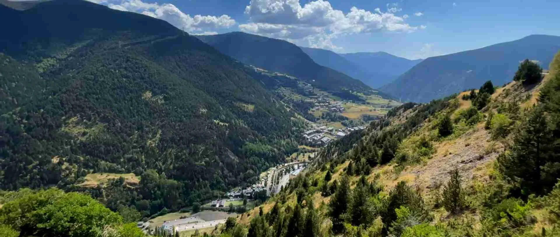
- Valley Geometry as Military Logic: Andorra’s seven-parish valley system constitutes a natural fortress whose mountain passes — none navigable without crossing Andorran territory — gave the co-principality its strategic survival advantage across centuries of European border conflict. The terrain did not supplement military infrastructure; it was the military infrastructure.
- The Pareage Paradox: The 1278 Pareage between Roger-Bernard III, Count of Foix, and Pere d’Urtx, Bishop of Urgell, simultaneously created the co-principality and ordered the demolition of existing castles, ensuring that Andorra’s defensive heritage survives primarily in ecclesiastical towers, watch-towers, and landscape features rather than castle keeps. The diplomatic act that secured sovereignty also erased much of the physical evidence of how that sovereignty had been defended.
- The Mechanics of Dry-Schist Construction: Dry-schist masonry — exploiting the natural cleavage planes of metamorphic schist found in Andorra’s northeastern anticlines — enabled medieval builders to raise walls, towers, and enclosures without mortar, relying on precise coursing, weight distribution, and interlocking bond patterns that have withstood centuries of seismic stress and freeze-thaw cycling.
- Churches as Military Infrastructure: Andorra’s Romanesque churches functioned simultaneously as sacred spaces and components of the defensive network. Their detached Lombard towers provided elevation for watchmen, their thick walls offered refuge, and their elevated positions on rocky outcroppings — Sant Joan de Caselles, Santa Coloma, Sant Vicenç d’Enclar — commanded the principal valley routes from heights that any fortification engineer would have recognized as optimal.
- Iron and Sovereignty: The iron-smelting economy of Andorra’s valleys, documented in the UNESCO-inscribed Madriu-Perafita-Claror cultural landscape, linked military capacity to environmental resource management. The same communal governance systems that regulated forest use for charcoal and grazing rights for transhumant herds also supplied the iron for tools, weapons, and hardware that sustained the fortification network.
- Roc d’Enclar as Chronological Anchor: Roc d’Enclar, occupied continuously from the third century AD through the medieval period, provides the most complete archaeological sequence of defensive architecture in Andorra, documenting transitions from a late-Roman hilltop enclosure through Carolingian-period modifications to the castle that the Pareage of 1278 required Roger-Bernard III to demolish — making it the essential key to reading the fortification landscape as a whole.
People Also Ask About Andorra’s Medieval Fortifications and Architecture
What defensive structures did medieval Andorra use to control its mountain passes?
Medieval Andorra controlled its mountain passes through a layered system that combined natural topography with purpose-built and adapted structures. The primary defensive layer was geographic: the valley system forced all movement through narrow corridors at specific entry points, where even a small garrison could hold off a much larger force. Above these corridors, the principal structural elements were watch-towers (of which Torre dels Moros at Les Bons is the best-preserved example), fortified complexes on rocky promontories (Roc d’Enclar being the most archaeologically documented), and the elevated bell towers of Romanesque churches, which served dual functions as observation posts and refuges. The 1278 Pareage between the Count of Foix and the Bishop of Urgell mandated demolition of the principal castle fortifications, which is why tower-and-church structures now dominate the surviving record over keep-and-ward castles. Additionally, the communal governance of the parishes gave valley residents a collective stake in pass control, supplementing military architecture with organized civic response.
How does dry-schist construction work, and why was it favored in the Pyrenean valleys?
Dry-schist construction exploits the inherent foliation of metamorphic schist rock, which splits naturally along parallel planes to produce flat, roughly tabular stones suitable for wall-building without mortar. Builders select and grade stones by thickness, placing the largest and most regular pieces in the lower courses to distribute load, while smaller and irregularly shaped fill pieces lock the faces together. Corner solutions require careful selection of angular stones that can interlock on two faces simultaneously — these are among the most skilled elements of dry-stone practice. The system performs well in mountain environments because it has no rigid mortar joints to crack under freeze-thaw cycling or seismic movement; instead, walls flex and self-adjust within limits. Schist was favored in Andorra’s northeastern valleys (particularly around Canillo and Encamp) because outcrops of the foliated metamorphic rock were immediately available in the hillsides surrounding building sites, eliminating the need for long-distance stone transport in terrain where cartage was difficult. The result was a construction culture in which every defensive wall, pastoral enclosure, terrace, and track used essentially the same material and the same technical vocabulary.
What is the architectural relationship between Andorran Romanesque churches and military defense?
The Romanesque churches of Andorra occupy the intersection between ecclesiastical and military architecture in a way that reflects both the political conditions of the co-principality and the practical requirements of valley defense. The churches built between the ninth and twelfth centuries are characteristically positioned on rocky outcroppings above valley floors — Sant Vicenç d’Enclar rises 150 metres above the Santa Coloma plain, Sant Joan de Caselles sits on a rock directly above the principal route to France — giving their bell towers the same sightlines that a purpose-built watch-tower would require. In the case of Sant Romà de Les Bons, the church and a four-storey defensive tower form an integrated complex at the fortified settlement of Les Bons. The bell towers themselves, built in the Lombardy style with their characteristic bands of blind arcading and pilaster strips, are structurally independent of the nave and apse, which in many cases allowed them to be used as observation and signaling points without disrupting liturgical function. Thick rubble schist walls throughout these buildings, often exceeding a metre in depth, provided the structural depth that doubled as defensive mass.
How does the Madriu-Perafita-Claror Valley UNESCO inscription relate to the fortification landscape?
The Madriu-Perafita-Claror Valley was inscribed as a UNESCO World Heritage cultural landscape in 2004 under criterion (v), recognizing it as an outstanding example of how high-Pyrenean communities managed and occupied mountain territory over millennia. The inscription specifically identifies stone tracks, terraced field systems, summer pastoral settlements (bordes), and the physical remains of iron-smelting operations as the key elements of the cultural landscape. These features connect directly to the fortification landscape in two ways. First, the iron-smelting remains in the valley document the economic basis for the metallurgical production that supplied hardware to the military infrastructure throughout the principality — weapons, tools, door and gate fittings, arrow tips, and structural ironwork for buildings. Second, the communal land-management systems that the UNESCO inscription identifies as surviving for over 700 years are the same governance frameworks that organized parish defense, coordinated the maintenance of watch-towers, and regulated the mountain passes. The valley is, in this sense, not simply a scenic landscape but an archive of the institutional arrangements that made Andorra’s fortification system function.
Extended multi-day tours – 5+ days
Featured Andorra Multi-Day Tour Packages
3 days
Andorra 3-Day Discovery Tour
- ✓ Comprehensive Andorra experience
- ✓ Expert local guides included
- ✓ All accommodation included
- ✓ Transportation provided
5 days
Andorra 5-Day Highlights Experience
- ✓ Comprehensive Andorra experience
- ✓ Expert local guides included
- ✓ All accommodation included
- ✓ Transportation provided

7 days
Andorra 7-Day Cultural Journey
- ✓ Comprehensive Andorra experience
- ✓ Expert local guides included
- ✓ All accommodation included
- ✓ Transportation provided

10 days
Andorra 10-Day Complete Adventure
- ✓ Comprehensive Andorra experience
- ✓ Expert local guides included
- ✓ All accommodation included
- ✓ Transportation provided
Multi-day tour packages powered by TourRadar. Prices and availability subject to change.
Introduction: The Microstate That Survived Through Stone and Strategy
Among the political anomalies of European history, the survival of Andorra as an independent principality stands as a remarkable testament to the combined power of geography, institutional ingenuity, and what might be called a stone logic — a deep coherence between the available building material, the defensive requirements of the terrain, and the social organization of the people who inhabited it. The principality occupies approximately 468 square kilometres of the eastern Pyrenees, arranged along the drainage basins of the Gran Valira river and its tributaries, at elevations ranging from roughly 840 metres in the capital valley to over 2,900 metres at the highest ridgelines. Every metre of this altitudinal range contributed to a defensive calculus that Andorra’s medieval inhabitants understood with practical precision.
The concept of “the iron passes” — as this analysis deploys the phrase — refers to the network of mountain passes (ports and colls in Catalan) through which access to Andorran territory was channeled, controlled, and when necessary contested. “Iron” operates here on three registers simultaneously. At the most literal level, it acknowledges the iron-smelting economy whose physical remains survive in the Andorran valleys — the ferreries, the ore deposits, and the forge sites documented by archaeology — and which provided both the wealth and the manufactured materials that sustained the fortification network. At a metaphorical level, the “iron pass” is the impenetrable passage: the route that cannot be forced without prohibitive cost in men and time. And at a conceptual level, the phrase connects Andorra’s military geography to the broader Pyrenean tradition of pass control, in which command of the high crossings determined the political fate of the territories on either side.
The analysis proceeds through the material evidence: the geological character of Andorran schist and its structural properties, the specific archaeological sequences at key fortified sites, the architectural logic of the Romanesque church-tower system, and the landscape evidence preserved in the UNESCO World Heritage Site of the Madriu-Perafita-Claror Valley. It situates this evidence within the political history of the co-principality — particularly the crucial 1278 Pareage that reshaped Andorra’s fortification landscape as comprehensively as any invasion might have — and in the broader context of Pyrenean border defense systems.
Understanding Andorra’s medieval fortifications requires abandoning the conventional expectation of massive curtain walls, great towers, and elaborate gatehouse complexes. The principality’s defensive architecture operated at a different scale and through a different logic — one in which the valley system itself did the work that stonework had to do elsewhere, in which the church tower served the function of the military tower, in which dry-stone enclosures and terraced field systems constituted territorial occupation as surely as garrisoned castles. The result is a military landscape that is, paradoxically, most visible when least expected: in the siting of a church, the height of a bell tower, the precision of a schist wall corner, the alignment of a mountain track toward a pass that no army crossed without consequence.
The Valley System as a Fortress: Andorra’s Geographic Military Logic
The Seven Parishes and Their Valley Corridors
Andorra’s seven administrative parishes — Andorra la Vella, Canillo, Encamp, Escaldes-Engordany, La Massana, Ordino, and Sant Julià de Lòria — correspond directly to the major drainage basins that structure the territory. Each parish occupies a distinct valley or sub-valley, connected to the central corridor of the Gran Valira through lateral tributary systems. This administrative geography is not coincidental: it maps onto the pre-existing pattern of pastoral territory management in which communities organized themselves around the watersheds they exploited for grazing, forestry, and agriculture. The same geographical unit that defined a social and economic community also defined a defensive responsibility. The parish was simultaneously the unit of governance, economic exploitation, and territorial protection.
The terrain of each valley corridor has a characteristic profile that shapes its defensive logic. The lateral valleys — particularly those of the Valira del Nord (serving La Massana and Ordino) and the Valira d’Orient (serving Canillo) — narrow dramatically at their upper ends, where tributary gorges meet the main valley floor. At these natural chokepoints, a relatively small defensive installation could control access to the entire upper valley system. This principle explains the siting of watch-towers at precisely these transition points: structures like the complex at Roc d’Enclar, positioned above the confluence of the Enclar valley with the lower Andorra la Vella plain, commanded the southward route through the territory with an unobstructed sightline that no force entering from the south could avoid passing beneath.
The elevational compression of the Andorran valleys is equally significant. The territory rises from roughly 840 metres at the confluence of the north and south Valira rivers to over 2,400 metres at the Port d’Envalira, a change of more than 1,500 metres within a linear distance of approximately 25 kilometres. At these gradients, the vegetation zones shift rapidly from irrigated valley-bottom cultivation through mixed montane forest to high alpine pasture, with each zone presenting distinct defensive properties. The forested mid-slopes that medieval builders could not see over from the valley floor were precisely the zones where watch-towers on rocky outcroppings above the tree-line justified their construction costs.
The Mountain Pass Network and Strategic Chokepoints
Andorra’s boundaries are defined not by rivers, watersheds, or cultural frontiers so much as by the ridgelines that separate its drainage systems from those of neighboring territories. The mountain passes that breach these ridgelines are Andorra’s natural borders — and, during the medieval period, its military frontiers. The principal passes can be grouped by their strategic function: northern passes connecting to the Ariège and the territories of the Count of Foix; eastern passes connecting to the Cerdanya and the route toward the Pyrenees Orientales; and western passes connecting to the diocese of Urgell and the territories of the Bishop, the co-prince’s counterpart.
The Port d’Envalira, at 2,408 metres the highest paved road in the Pyrenees today, served as the primary northern gateway. The pass connects the upper Encamp valley to the French side through the territory now occupied by Pas de la Casa — a settlement whose very name, “the pass of the house,” records the fact that until modern times the only structure at this crossing was a single shepherd’s hut. That isolation is itself a military fact: a pass so high and so exposed to weather that permanent garrison was impractical, requiring instead a system of mobile response from fortified positions lower in the valley. The towers and church positions at Canillo — principally Sant Joan de Caselles, sited directly on the approach road below the pass — fulfilled exactly this strategic function, allowing defenders to intercept any force that had descended from the Envalira before it could reach the populated lower valley.
The southern approaches, through Sant Julià de Lòria and the lower Valira corridor, presented a different tactical problem. The gorge through which the Valira exits Andorra toward La Seu d’Urgell is the most accessible entry point into the principality from Spain, at lower elevation and with less severe weather exposure than the northern passes. The fortified complex at Roc d’Enclar, positioned on a promontory 150 metres above the valley floor, commanded this corridor directly. Its archaeological record shows that this commanding position was recognized and exploited from the third century AD, long before any formal political organization of the valley system.
Rivers as Barriers and Routes of Control
The Valira system — the Gran Valira and its two principal tributaries, the Valira del Nord and the Valira d’Orient — runs through the central corridor of the territory as both a barrier and a logistical route. In spring, fed by snowmelt from elevations above 2,000 metres, these rivers run high and fast, making lateral crossing difficult without bridges. The medieval bridges of Andorra — built, like the walls and towers, in local schist and granite — were strategic assets as important as any fortification, because the control of a river crossing was equivalent to the control of the route it served. The stone tracks that connect the valley-bottom settlements to the high pastoral zones pass through precisely these crossing points, meaning that any force using the valley system moved along routes that were surveyed, known, and controlled by the local population in detail that an invader could not replicate.
This asymmetry of local knowledge — an attacker moving along known routes surveyed by defenders from above, through terrain where every rock outcropping, every narrowing of the valley floor, every bridge and ford was a potential killing ground — is the fundamental military advantage that the Andorran landscape conferred. No amount of numerical superiority fully compensated for the disadvantage of operating in unfamiliar high-altitude terrain against defenders who had grown up in it and managed every feature of it for generations.
The Iron Passes: Fortified Routes and the Archaeology of Pass Control
The Concept of the Controlled Pass in Pyrenean Military History
The strategic significance of the Pyrenean mountain passes has been recognized since antiquity. Hannibal’s crossing of the Pyrenees in 218 BC, the Visigoths’ use of specific passes to enter the Iberian Peninsula, and the Carolingian military organization of the Spanish March all reflect the geopolitical fact that high mountain ranges become, in military terms, a sequence of gates rather than an impenetrable wall. The passes are the gates; whoever holds the gates holds the mountain. In the Pyrenean case, the passes at usable altitudes for military movement are relatively few, and each has its own seasonal calendar of accessibility, its own approach gradient, and its own exposure to weather — characteristics that shape the defensive installations appropriate to each.
The eastern Pyrenees, where Andorra sits, have a higher and more continuous ridgeline than the central and western sections, making their pass system more restricted and more easily controlled. The passes accessible to wheeled transport or significant troop movement are concentrated at a small number of points, while the high colls above 2,000 metres are usable only by foot and by expert mountain guides. This restriction created a situation in which the control of two or three principal passes — through permanent or rapid-response military presence backed by the local population’s knowledge and organization — was sufficient to make the territory militarily coherent as a defensive entity. Andorra, of the passes that breached its borders, effectively controlled access from both the French and Spanish sides through a combination of terrain difficulty and targeted infrastructure.
Port d’Envalira and the Northern Gateway Architecture
The northern approach to Andorra through the Port d’Envalira required any force coming from the Ariège to ascend to 2,408 metres before descending into the Encamp parish. At this altitude, with the approach exposed to Pyrenean weather for the final kilometres of ascent, a relatively small defending force positioned at the mid-valley points below could effectively dictate the terms of any engagement: the attacker arrived exhausted and weather-stressed, with limited visibility into the lower valley where defenders had the advantage of knowing the ground. The architecture of this defensive system concentrated not at the pass itself but at the point where the descending force entered the inhabited zone — specifically at the Sant Joan de Caselles position above Canillo, where the road narrows and the bell tower commands the route from a rock spur on the eastern valley wall.
The lateral valleys feeding into the Encamp corridor — including the upper Madriu system that now forms the UNESCO World Heritage Site — provided additional complexity for any invading force attempting to spread laterally once in the main valley. The high pastoral zones, accessible only through known tracks, were managed by the local population in ways that made them both economically valuable and militarily sensitive. The shepherds and iron-workers who moved through these lateral valleys during the summer months served an information function: they knew who was on the mountain, which tracks were passable, and how quickly a force could move through the terrain. This human intelligence network, overlaid on the physical landscape, made the defense of the northern approaches far more effective than the limited built military infrastructure alone could have achieved.
Southern Entry Points and the Gran Valira Corridor
The southern entry into Andorra through Sant Julià de Lòria and the lower Valira gorge presented a fundamentally different tactical problem. This approach is lower, warmer, and more accessible than the northern route, making it the natural entry point for any force coming from the diocese of Urgell. The response to this vulnerability was the construction and occupation of the Roc d’Enclar complex, which positioned a fortified presence directly above the corridor at a point where the valley narrows between the rocky spur of Enclar and the opposing valley wall.
The Roc d’Enclar position commands the entry to the central valley from a promontory that rises 150 metres above the Santa Coloma plain — sufficient height to observe movement throughout the lower valley system while being difficult to approach without being observed from above. Archaeological excavation of the site has documented occupation beginning in the third century AD, with the recovery of Roman coins bearing the images of emperors Gallienus (260-268 AD), Magnus Maximus (382-388 AD), and Honorius (395-423 AD). This sequence establishes that the strategic value of the Roc d’Enclar position was recognized in late-Roman antiquity and exploited continuously through the Visigothic period, when the site began developing into the more elaborate fortified complex that the Carolingian period would expand and the 1278 Pareage would require to be demolished.
The Signal Tower Network and Military Communication
The effectiveness of the Andorran defensive system depended on communication: the ability to relay information about a threat from the frontier passes through the valley system to the population centers in time for a coordinated response. The watch-towers, elevated church towers, and promontory positions of medieval Andorra were connected by sightlines that formed a signal relay network, in which smoke by day and fire by night could transmit a warning through the territory within minutes. The Les Bons complex — combining the Torre dels Moros, the Sant Romà church tower, and the elevated position above the Encamp valley — was specifically connected to the Roc d’Enclar complex through a clear sightline, as confirmed by landscape analysis. A watcher at Roc d’Enclar could relay a warning signal to Les Bons, which could in turn signal toward the upper Valira d’Orient corridor and the approaches to the Envalira pass. This relay logic explains the placement of structures that otherwise seem isolated or redundant when considered in isolation: each one forms a necessary node in a landscape-scale communication system.
Political Context for the Fortifications: From Carolingian March to Pareage
Carolingian Origins and the Defense of the March
The political context that produced Andorra’s medieval fortification system begins with the Carolingian reorganization of the Pyrenean frontier in the late eighth and early ninth centuries. The reconquest of northeastern Iberia from the Umayyad emirate, achieved by Charlemagne’s forces between 795 and 810 AD, established a series of buffer territories — the Spanish March — between Frankish Gaul and the Islamic south. Andorra, controlling key passes between Gaul and the Iberian interior, was incorporated into this march system as part of the county structure that governed the Carolingian frontier. The Count of Urgell, a Carolingian appointee, held nominal authority over the territory, and it was in this period that the more elaborate phase of fortification at Roc d’Enclar began, with the construction or expansion of the castle complex on the promontory above Santa Coloma.
The Carolingian period also corresponds to the construction of the earliest churches in Andorra’s ecclesiastical record. The church at Sant Vicenç d’Enclar, integrated into the Roc d’Enclar fortified complex, is dated to the eighth century by architectural analysis, making it the oldest surviving structure in the principality. Its construction as part of the fortified complex — rather than as a separate parish church in a settlement — reflects the dual function of Carolingian ecclesiastical foundations in the march, where the church served simultaneously as a religious institution, a center of local administration, and an element of the military presence.
The Counts of Urgell, Foix, and the Competition for Andorra
The subsequent history of Andorra before the Pareage of 1278 is a sequence of contested claims between the ecclesiastical authority of the Bishop of Urgell — successor to the Carolingian counts in the religious administration of the territory — and the secular authority of the various lay powers that sought to exercise temporal control over the passes. The Count of Foix, whose territory in the Ariège lay directly to the north of Andorra, was the principal lay claimant; his interest was straightforward: control of the Andorran passes was equivalent to control of the commercial and military routes between his northern territories and the Iberian interior.
The fortification of the Andorran territory in the eleventh and twelfth centuries — the period that produced most of the Romanesque architecture still visible today — reflects this competition. The construction of new or expanded church-towers, the maintenance of the Roc d’Enclar complex, and the development of the tower network at Les Bons and in the Encamp valley all reflect the active militarization of a territory whose control was actively contested. Each co-claimant had an interest in maintaining military presence that the other could not easily dislodge, which paradoxically produced a more elaborate and distributed defensive infrastructure than a single sovereign controlling the territory might have developed.
The 1278 Pareage and Its Architectural Consequences
The Pareage of Andorra, signed at Lleida on 8 September 1278 between Roger-Bernard III, Count of Foix, and Pere d’Urtx, Bishop of Urgell, established the co-principality’s foundational constitutional arrangement: joint sovereignty over Andorra, shared administrative and judicial authority, and a symbolic annual fee (the questia) payable to both co-princes. The co-principality structure this treaty established has persisted, with modifications, to the present day, making the 1278 document one of the most consequential pieces of medieval constitutional architecture in European history.
For the physical landscape of Andorra, however, the Pareage’s consequences were immediate and transformative. The treaty included a provision requiring the demolition of existing castle fortifications — a clause that the Count of Foix, as the party with the largest military presence in the territory, was obliged to execute. The Roc d’Enclar castle, whose fortifications had commanded the southern valley approach for centuries, was stripped of its defensive walls and towers pursuant to this obligation. The physical evidence of this demolition is visible in the archaeological record: the surviving structures at Roc d’Enclar are exclusively the church of Sant Vicenç d’Enclar (which as an ecclesiastical building was outside the scope of the demolition order) and the bare promontory from which the castle’s walls were removed.
The Pareage’s demolition clause explains one of the most striking characteristics of Andorra’s medieval built heritage: the near-complete absence of castle keeps, curtain walls, and gatehouse complexes despite a documented medieval political history that clearly required significant military infrastructure. The structures that survive — towers, church complexes, promontory positions — are precisely those that fell outside the strict definition of “castle” in the treaty language, or that were built or rebuilt after the Pareage in forms that did not technically violate its terms. The Torre dels Moros at Les Bons, for example, is associated in its Catalan-language sources with late-sixteenth-century Huguenot incursions — suggesting that whatever earlier structure the site may have had was replaced or rebuilt after the medieval clearing, in a period when the Pareage’s demolition obligations were interpreted as exhausted.
Dry-Schist Engineering: Geology, Material Properties, and Construction Logic
The Geological Character of Andorran Schist
Andorra’s geological profile is a product of the Pyrenean orogeny, the mountain-building event that created the range during the Mesozoic and early Cenozoic by collision between the Iberian and European tectonic plates. The resulting rock sequence in Andorra exposes a variety of metamorphic and sedimentary formations, with the specific character of available building stone varying significantly by valley location. In the northeastern anticlines — particularly in the parishes of Canillo and Encamp — the rock exposed at surface is primarily gneiss and schist, metamorphic rocks formed by the deep burial and recrystallization of older sedimentary sequences under pressure and heat. These rocks have the characteristic foliation — the parallel alignment of mineral crystals along planes of preferred orientation — that produces the flat-cleaving properties essential to dry-stone construction.
The schist of Andorra’s northeastern valleys is primarily composed of muscovite and quartz, with accessory minerals that give the rock its characteristic silvery-grey to dark grey appearance. Its foliation planes are typically spaced between 5 and 30 millimetres apart, producing naturally flat stones when the rock is split along these planes — a quarrying process that requires only simple tools and the skill to identify and exploit the natural cleavage. The result is a building stone that is effectively pre-shaped by its geology: the flat faces of schist slabs are smooth enough to seat reliably on one another without mortar, and their surface roughness provides the friction that holds courses in position under load.
By contrast, the more westerly and southerly parishes — including parts of Sant Julià de Lòria and Escaldes-Engordany — expose more massive granite, a coarser-crystalline rock without foliation that splits into blockier, less predictable shapes. Building in granite requires more working of the stone to produce usable faces, and dry-stone construction in granite is consequently coarser and less precisely coursed than in schist. The archaeological and vernacular record of the two zones reflects this material difference: the most precisely coursed walls and towers are concentrated in the schist zone, while the granite areas show a different constructional vocabulary that relies more heavily on mortar filling and less on the precision dry-joint technique.
Quarrying and Stone Selection
The quarrying of schist for wall construction in Andorra required no specialized infrastructure. Outcrops of the foliated rock, exposed at surface throughout the northeastern valley hillsides, provided building material within short carrying distances of almost every building site in the schist zone. The quarrying method was straightforward: a mason would identify a surface or near-surface exposure of well-foliated schist, drive wedges or wooden stakes into the foliation planes, and lever off slabs of predictable thickness. The skill lay in selecting exposures where the foliation was regular and well-developed, and in choosing slabs of appropriate thickness for different parts of the building: thicker slabs for the base courses, where bearing load is greatest; thinner slabs for the upper courses and facing, where lighter stones reduce the dead load on the wall below.
The quarry sites associated with specific structures are in many cases identifiable archaeologically by the scatter of schist waste — irregular fragments produced when slabs split off-plane or were trimmed to required dimensions. Around the Sant Joan de Caselles church, for example, the characteristic silvery schist of the tower and nave contrasts with the irregular granite boulders used for the lower terrace retaining walls, indicating that the builders selected material from different local sources for different structural functions.
Dry-Stone Construction Techniques: Coursing, Bonding, and Corner Solutions
Dry-schist masonry walls in Andorra’s military and ecclesiastical structures follow a consistent set of constructional principles adapted to the material’s properties. The typical wall section consists of two faced courses — outer and inner — with a rubble core of smaller schist fragments packed between them. The facing courses are laid with the flat foliation plane of each stone horizontal, maximizing contact area between adjacent stones and distributing load evenly downward. Vertical joints between stones in adjacent courses are staggered — the principle of bond — to prevent the formation of continuous vertical cracks through which structural failure could propagate.
Corner solutions represent the highest technical demand of dry-stone construction, because at a corner two perpendicular wall faces must be connected by stones that lock them together. In schist masonry, this is achieved by selecting large, roughly squared stones — “quoins” — that extend into both wall faces simultaneously, bonding them together through their own weight and the friction of their flat faces. The quoins at the corners of surviving Andorran towers, particularly at Torre dels Moros and the Sant Joan de Caselles bell tower, show careful selection of stones with naturally right-angled or close-to-right-angled edges: the material’s foliation, normally planar, occasionally produces these angular pieces when the rock has been subjected to minor folding or shear.
For military towers, where wall thickness and the resistance of the base to undermining were critical, the lower courses are characteristically constructed with the largest available schist slabs laid as through-stones — single pieces extending the full depth of the wall. These through-stones prevent the two faces from separating under lateral load, and in the schist zone they are typically 60-100 centimetres long and 10-20 centimetres thick. Their visual effect on the wall face — a regular alternation of long thin slabs and shorter fill pieces, in a pattern sometimes called herringbone or long-and-short work — is one of the characteristic signatures of high-quality Andorran military masonry.
Structural Performance of Schist Walls in a Mountain Environment
The structural logic of dry-schist construction proved remarkably well-adapted to the specific challenges of the Pyrenean mountain environment. The principal structural threats to masonry in this zone are freeze-thaw cycling, seismic loading, and differential settlement due to the rocky, uneven foundation conditions of hillside building sites. Mortar-jointed masonry is vulnerable to all three: mortar joints crack when they freeze, remain cracked when the ice melts, and accumulate damage through repeated cycles; seismic loading opens cracks at mortar joints that do not close again; differential settlement introduces bending forces that mortar joints cannot resist.
Dry-stone construction is inherently more resilient against these threats. Without rigid mortar joints, the wall can accommodate small movements — seasonal thermal expansion and contraction, minor seismic vibration, slight settlements — without developing cracks. The individual stones reset their positions slightly through each stress event and find new equilibrium positions. This self-adjustment mechanism is limited: beyond a certain threshold of deformation, dry-stone walls do fail progressively as individual stones shift out of their stable positions. But within the range of stresses typical of the Pyrenean mountain environment, the dry-stone schist walls of Andorra’s medieval structures have proven more durable than equivalent mortar-jointed construction would have been, as evidenced by the survival of substantial sections of wall at sites where mortar-jointed structures of the same age would have required extensive reconstruction.
Military Tower Architecture in Andorra
Roc d’Enclar: The Definitive Archaeological Sequence
The promontory of Roc d’Enclar, 150 metres above the Santa Coloma plain in the parish of Andorra la Vella, provides the most complete archaeological record of defensive architecture in the principality. Excavations conducted in 1979 and 1993, together with subsequent work at the associated Roureda de la Margineda site (excavations beginning in 2007), have documented a continuous sequence of occupation and construction from the third century AD through the medieval period, yielding thousands of ceramic, iron, and bronze objects that illuminate the material culture of the fortified site across its entire operational history.
The earliest phase, dated by the Roman coins recovered from the lowest archaeological deposits, represents a late-Roman hilltop enclosure: a defended position on the granite promontory that exploited the natural defensibility of the site without necessarily including elaborate built fortifications. The transition to a more architecturally developed fortified complex began in the Visigothic period, when new areas of the promontory were cleared and structural foundations were established — a process documented in the archaeological record by the sequence of foundation deposits and the associated pottery assemblage. The church of Sant Vicenç d’Enclar, built in the eighth century (and thereby the oldest surviving building in Andorra), represents the consolidation of this fortified complex into the characteristic Carolingian form: a castle with an integrated ecclesiastical component whose bell tower served both liturgical and military observation functions.
Following the Pareage of 1278, the demolition of the castle fortifications left the Sant Vicenç church standing alone on the promontory. The church’s survival — while the castle was demolished around it — testifies both to the ecclesiastical protections that the Pareage extended to religious buildings and to the continued importance of the site as a religious and community anchor after the military justification for its fortification was removed. The architectural remains of the church today include its original eighth-century nave, in pre-Romanesque style showing the characteristic features of Catalan and Languedocian architecture of that period, with a rectangular nave and square apse in rubble schist masonry.
Torre dels Moros at Les Bons: A Tower of Contested Chronology
The Torre dels Moros — “the Tower of the Moors” — at Les Bons in the parish of Encamp is the most evocative surviving watch-tower in Andorra, combining a dramatic silhouette against the upper Encamp valley with a chronological ambiguity that reflects the complex history of the site. The tower’s popular name records a folk etymology common throughout the Iberian Peninsula, where any structure of unknown or ancient-seeming origin was attributed to “the Moors” regardless of its actual date or builders; the tower is demonstrably of Christian origin, though its precise construction date remains disputed between sources that suggest a twelfth-century origin and those that associate it with the late-sixteenth-century period of Huguenot incursions into Andorra.
The structural evidence of the tower itself includes features consistent with both periods. The loopholes — narrow, splayed embrasures through which missiles could be discharged while providing minimal target to attackers outside — are of a type found in Pyrenean military structures from the twelfth century onward. The machicolations at the tower’s upper level, projecting corbels that created floor openings through which stones or boiling liquids could be dropped on attackers directly below the wall base, are a feature that developed in Pyrenean military architecture during the thirteenth and fourteenth centuries but remained in use into the sixteenth. The evidence of fire damage — reddening of the interior masonry walls, indicating a significant fire that the stonework survived — is consistent with the Huguenot incursion narrative recorded in local sources, suggesting that whatever earlier structure the site may have had, the visible tower represents either a late-medieval or early-modern phase of construction or reconstruction.
What is not disputed is the tower’s function and its place in the valley defense system. Positioned on an elevated spur above Les Bons village, with clear sightlines to the Roc d’Enclar complex to the southwest and toward the upper Valira d’Orient approach to the northeast, the tower forms a critical node in the signal relay network described above. The Sant Romà chapel adjacent to the tower carries twelfth-century frescoes of exceptional quality — including a representation of the Last Judgment — that confirm the medieval importance of the site as a community center and suggest that the church and tower together formed an integrated defensive-religious complex analogous to, if smaller than, the complex at Roc d’Enclar.
The Typology of Andorran Watch-Towers
The watch-towers of Andorra represent a coherent typological family defined by common functional requirements and common material constraints. All examples exploit elevated terrain: rocky spurs, promontory edges, or ridgeline positions that provide maximum visibility over the approach routes they surveyed. All are constructed in local schist or granite using the dry-stone or minimal-mortar techniques appropriate to the available material. All were designed for a small permanent garrison or watch team rather than for sustained sieges — they have neither the cisterns, the storage facilities, nor the spatial complexity of structures intended for extended occupation under pressure.
The typical Andorran watch-tower of the medieval period was a square or slightly rectangular plan, approximately 5-8 metres per side externally, with walls of 1-1.5 metres thickness. Floor-to-floor heights of approximately 3 metres gave four to five storeys within a total height of 12-18 metres — sufficient to command sightlines over surrounding vegetation while remaining inconspicuous from a distance. Entry was typically through a doorway set above ground level, accessible only by a removable wooden ladder that denied entry to attackers who had reached the base of the wall. Interior floors were of timber, supported on corbels projecting from the inner face of the schist walls — a detail that allowed the floors to be replaced as required without structural intervention in the walls themselves.
Ecclesiastical Architecture as Military Infrastructure
Sant Vicenç d’Enclar: Sacred Fortress Above the Central Valley
Sant Vicenç d’Enclar, standing on the Roc d’Enclar promontory 150 metres above Santa Coloma, is simultaneously the oldest building in Andorra and the clearest example of the fortified church-complex type that characterizes the principality’s defensive ecclesiastical heritage. Built in the eighth century in a style showing the characteristic features of Carolingian religious architecture in the Catalan Pyrenees — a rectangular nave, a simple square apse, rubble schist walls without applied decoration — the church served as the religious anchor of the fortified complex whose demolition the 1278 Pareage required.
The church’s position on the promontory gave its tower — a cylindrical bell tower added in the twelfth century, rising to 18 metres — sightlines over the entire lower Valira corridor and the principal approach from the south. Archaeological excavations around the church have recovered remains of medieval fortifications and adjacent structures that document the extent of the integrated complex, including evidence of medieval domestic occupation suggesting that the promontory served as a refuge for the surrounding population during periods of threat, rather than merely as a military garrison post. This dual function — religious center and community refuge — is characteristic of the Carolingian-period fortified church type throughout the Pyrenean region.
Sant Joan de Caselles: The Pass-Watcher’s Tower at Canillo
The church of Sant Joan de Caselles, built in the eleventh and twelfth centuries on a rock spur directly overlooking the main valley road between Canillo and the Port d’Envalira, is the most architecturally accomplished of Andorra’s Romanesque churches and the clearest example of how ecclesiastical siting and military siting converged in the principality’s defensive system. The church is positioned on a rock outcropping that rises above the road connecting the populated valley floor to the northern pass, placing its Lombard bell tower — 24 metres in height and structurally independent of the nave — at an elevation from which the entire road corridor leading to the Envalira approach is visible.
The bell tower’s design is characteristic of the Lombard Romanesque tradition that spread through the Catalan Pyrenees in the eleventh century: a square plan, blind arcading in alternating courses at the upper levels, and a corbelled parapet that provided the defensive-functional equivalent of crenellation without explicitly military form. The structural independence of the tower from the nave — a characteristic feature of Lombard church design — meant that the tower could be used for observation and signaling without interfering with liturgical functions in the nave below. The tower’s thick schist walls, laid in the precise herringbone-and-long-joint technique characteristic of high-quality Andorran military masonry, give the structure a visual solidity that communicates both permanence and resistance — qualities equally valued in a military watchtower and in the architectural expression of the church’s institutional authority.
Inside the church, a twelfth-century stucco Majesty — a sculptural representation of the crucifixion with Saint Longinus, Stephaton, and the sun and moon — and the remains of painted frescoes of comparable date document the quality of the artistic investment that the community and its patrons directed toward this valley-guarding church. The quality of this investment is itself a strategic signal: a church that contains significant artistic resources is a church that will be defended, maintained, and occupied, which makes it a more credible element of the military landscape than a purely utilitarian watch-post would be.
Santa Coloma: The Cylindrical Tower and Pre-Romanesque Continuity
The church of Santa Coloma, located in the village of the same name just outside Andorra la Vella, represents the earliest surviving ecclesiastical structure in the lower central valley corridor, with the original nave dated to the ninth and tenth centuries in a pre-Romanesque style. Its cylindrical Lombard bell tower, added in the twelfth century and rising to 18 metres, is the most unusual architectural feature in Andorra’s Romanesque heritage: while square or slightly rectangular bell towers are the norm throughout the Catalan Pyrenees, the cylindrical form at Santa Coloma reflects either a distinct local tradition or the influence of specific architectural contacts that have not been identified with certainty.
The structural properties of a cylindrical tower differ from those of a square tower in militarily relevant ways. A circular plan eliminates the corner — the point of maximum structural vulnerability in any rectangular tower, where two perpendicular wall faces meet at an acute stress concentration. Under seismic or impact loading, corners are the first parts of rectangular towers to fail, while cylindrical walls distribute stresses evenly around the perimeter. For a tower in an earthquake zone and at altitude in a freeze-thaw environment, the cylindrical form provides structural advantages that a Romanesque builder with knowledge of tower failures in the region would have recognized and valued. Whether the choice of cylindrical form at Santa Coloma was primarily motivated by structural, aesthetic, or symbolic considerations is not established in the surviving documentary or archaeological record; the structural benefit, however, is demonstrable.
The Santa Coloma church carried one of the richest pictorial programs in Andorra, a fresco cycle that was removed from the building around 1930 and, after a period of uncertain provenance including travel through Europe during the Second World War, was recovered by the Andorran government in 2007. The recovery and repatriation of this cycle represents a significant heritage conservation achievement, and its current display — in combination with video mapping technology that recreates its original spatial context — makes Santa Coloma one of the most interpretively complete of Andorra’s Romanesque heritage sites.
Sant Romà de Les Bons: The Church-Tower in the Fortified Enclosure
The church of Sant Romà de Les Bons, integrated into the Les Bons fortified settlement alongside the Torre dels Moros, represents the closest surviving parallel in Andorra to the fully integrated military-ecclesiastical complex type that the Pareage of 1278 largely eliminated. The church is the only example in Andorra with a Lombard-style semicircular apse, a feature that places its design in close relationship with the ecclesiastical architecture of the Ariège and the French Pyrenean counties to the north — a geographical connection consistent with the site’s role in the network of Foix-controlled positions in the upper Encamp valley.
The four-storey defensive tower associated with the church at Les Bons is documented in the sources as a later addition to the ecclesiastical core, with traces of a thirteenth-century civil house adjacent to the church indicating that the fortified enclosure was an inhabited settlement with military infrastructure rather than a purely military installation. The twelfth-century frescoes in the church nave, depicting biblical scenes including the Last Judgment, are of comparable quality to those at Sant Joan de Caselles and Santa Coloma, confirming the pattern in which Andorra’s most militarily significant ecclesiastical sites also received the most significant artistic investment — a pattern consistent with these sites functioning as the principal public and institutional centers of their respective valleys, in addition to their military functions.
Vernacular Architecture and Territorial Occupation: Bordes, Enclosures, and Landscape Fortification
The Borda System and Pastoral Territory Control
The borda — the seasonal pastoral farmhouse of the Andorran mountain zones — represents the most numerous and most widely distributed element of the medieval built landscape, exceeding in quantity all the towers, churches, and fortifications combined. Bordes are stone structures of typically modest scale: a ground-floor stable for animals, an upper floor for hay storage and occasional human occupation, and a form adapted to the requirements of summer pastoral occupation at altitudes between 1,600 and 2,200 metres. Their walls are in dry-stone schist or granite depending on locally available material; their roofs were traditionally of schist slabs or timber, with schist providing both thermal mass and weather resistance at altitude.
The territorial significance of the borda system lies in its relationship to the communal grazing systems that structured Andorran pastoral economics. The allocation of grazing rights, the management of the high summer pastures, and the regulation of forest exploitation for firewood and charcoal were all governed through the parish comú system — the communal governance structure that the Madriu-Perafita-Claror Valley UNESCO inscription identifies as dating back at least to the thirteenth century. Each borda was associated with specific grazing rights that established its builder’s or owner’s claim to a portion of the communal mountain resources. The distribution of bordes across the mountain landscape thus represents a material record of territorial occupation: a claim made in stone and validated through use, year after year, across centuries.
In military terms, the borda distribution effectively extended Andorran territorial presence through the high pastoral zones in ways that formal military installations could not. Shepherds in the high pastures knew the terrain in detail — which tracks were passable, which springs were reliable, which slopes offered cover from above — and their presence made the mountain zones difficult for any unfamiliar force to move through unobserved. The borda distribution also established a physical record of Andorran territorial claims that could be produced in any boundary dispute: a structure requires continuous maintenance, and continuous maintenance implies continuous presence, which implies territorial sovereignty.
Dry-Stone Enclosures, Field Systems, and Territorial Markers
The dry-stone enclosure walls that define the field systems of Andorra’s valley floors and mid-altitude pastoral zones are as much territorial documents as agricultural infrastructure. Built in local schist using the same techniques as fortification walls but typically at reduced thickness — 50-80 centimetres rather than the 100-150 centimetres of military work — these enclosures delineated the boundaries of individual cultivation plots, family orchards, and collectively managed pastures. Their construction required communal coordination: the management of boundary disputes, the allocation of labor for wall construction, and the maintenance of shared boundary sections were all functions of the parish governance system.
The most impressive examples of this enclosure landscape survive in the Madriu-Perafita-Claror Valley, where the UNESCO World Heritage Site inventory documents extensive networks of dry-stone terrace walls converting steep hillsides into level cultivation platforms. Terracing of this kind requires enormous collective labor investment — the movement of soil and the construction of retaining walls over hillside areas of many hectares — and its persistence over centuries testifies to the stability of the communal institutions that both created it and maintained it. The same schist-working skills used in terracing — the ability to course stones precisely, to manage drainage through carefully placed drainage channels, and to maintain wall faces under seasonal freeze-thaw stress — are the skills that produced the watch-towers and church walls of the fortification system. Vernacular and military construction in Andorra drew on a common technical culture, practiced and transmitted within the same communities.
Stone Tracks, Bridges, and Military Logistics
The network of stone-paved tracks that connected Andorra’s valley-floor settlements to the high pastoral zones and to the mountain passes represents the logistical infrastructure of both the pastoral economy and the military defense system. These tracks, surfaced in large flat schist slabs that resist erosion from foot and pack-animal traffic, followed routes optimized for multiple criteria: gradients manageable for loaded mules, drainage lines that remained passable after heavy rainfall, and sightline relationships that kept travelers visible from the valley-floor settlements for as long as possible. The UNESCO documentation of the Madriu-Perafita-Claror Valley specifically identifies stone tracks as one of the key elements of the cultural landscape, recognizing their role in the integrated management of mountain territory.
The bridges at river crossings on these tracks are some of the most technically accomplished pieces of schist construction in Andorra’s vernacular heritage. A dry-stone arch bridge over a Pyrenean torrent must accommodate the extreme hydraulic loading of spring snowmelt floods while maintaining its structural integrity without mortar — a demanding combination of requirements that medieval bridge builders met through the selection of large, precisely fitted schist voussoir stones for the arch and massive abutments that transferred arch thrust to the bedrock of the valley sides. The Pont de la Margineda, a medieval bridge at the junction of the Valira with the approach to Roc d’Enclar, exemplifies this construction tradition: a single schist arch spanning the torrent at a point where the valley sides are close enough together to contain the arch span within manageable dimensions, backed by substantial abutment masses that spread the arch’s horizontal thrust over a wide foundation area.
The Iron Economy and Military Capacity
Iron Ore Deposits and the Llorts Mining Tradition
Iron ore deposits occur throughout the Pyrenees, associated with the complex geological history of the range, but the Andorran valleys have their own documented tradition of ore extraction and processing that connects directly to the military landscape analyzed in this study. The Llorts mine in the parish of Ordino extracted iron ore commercially from the seventeenth through the nineteenth centuries, and its 30-metre network of tunnels now serves as a cultural history museum and a stop on the Pyrenean Iron Route — a multi-country heritage itinerary established by the European Institute of Cultural Routes. The commercial exploitation documented at Llorts in this relatively recent period built on a far older tradition of ore extraction and processing in the Andorran valleys.
The Pyrenean Iron Route itself is the critical heritage framework for understanding Andorra’s iron economy in its regional context. The route connects ore extraction sites, processing forges, and distribution networks throughout the Pyrenees from the Atlantic to the Mediterranean, documenting a regional iron industry that supplied tools, weapons, and hardware across a geographic area extending far beyond the individual valleys where the ore was extracted. Andorra’s contribution to this regional system was as both a producer — using its own ore deposits and its abundant forest resources for charcoal — and a transit zone through whose passes iron goods moved between the French and Spanish sides of the range.
The Ferreries and Their Strategic Importance
The ferreries — the iron forges of Andorra’s mountain valleys — represent the industrial infrastructure through which ore was converted into the usable metal that supported both the pastoral economy and the military establishment. A ferreria was typically sited at a point where a reliable water source provided power for the bellows and hammers, where accessible forest could supply charcoal, and where the output could be transported to distribution points. The Madriu-Perafita-Claror Valley UNESCO site specifically identifies “evidence of iron smelting” as one of the key features of its cultural landscape, and the remains of forge sites in the valley confirm that iron processing was conducted in the high pastoral zones as well as in the lower settlements.
The strategic importance of the ferreries extended well beyond their immediate economic function. A ferreria that produced blades, arrowheads, bolts for crossbows, and hardware for gates and portcullises was as important to the principality’s defensive capacity as a watch-tower or a fortified church. The ability to produce and repair weapons and fortification hardware locally, without dependence on external supply chains that could be interdicted, gave Andorra a degree of military self-sufficiency unusual for a territory of its size. The connection between the iron economy and the governance system is documented in the communal land-use regulations that structured access to forest resources: charcoal production required controlled coppicing of woodland, managed through the same parish comú system that coordinated military defense. The ferreria and the watch-tower were, in this sense, products of the same institutional infrastructure.
The Pyrenean Iron Route and Andorra’s Place in It
The inclusion of Andorra in the Pyrenean Iron Route heritage itinerary positions the principality’s iron-working tradition within a regional system of production and exchange that stretched from the Basque Country to Catalonia. The route documents how Pyrenean communities from the medieval period onward developed a specialized iron economy based on the particular combination of ore, water power, and forest resources available in the high valleys — a combination that was simultaneously geographically constrained (ore deposits, water courses, and forest are all geographically specific) and economically dynamic (the output could be marketed across a wide area through the pass routes that the same communities controlled militarily).
The strategic logic of this combination is striking: the mountain passes that gave Andorra its military survival advantage were the same routes through which its iron products reached external markets. Control of the passes served the iron economy as directly as it served the military defense. This dual function — the pass as military choke-point and as commercial artery — explains the intensity with which the co-principality’s institutions invested in pass control, and why the ferreria landscape and the fortification landscape should be read as components of a single integrated territorial system rather than as parallel but separate histories.
The Madriu-Perafita-Claror Valley: A Landscape Archive of Medieval Practice
UNESCO Inscription, Criterion (v), and the Cultural Landscape Framework
The Madriu-Perafita-Claror Valley was inscribed as a UNESCO World Heritage cultural landscape in 2004 (at the 28th Session of the World Heritage Committee in Suzhou, China), with a boundary extension in 2006, under reference number 1160bis. The inscription was made under criterion (v), which recognizes outstanding examples of traditional human settlement or land-use representative of a culture or cultures that reflect the interaction between human communities and their environments. The inscribed area of 4,247 hectares — approximately 9 percent of Andorra’s total territory — encompasses the complete drainage basin of the Madriu River in the southeastern part of the principality, including its tributary valleys of Perafita and Claror.
The cultural landscape framework is particularly apt for the Madriu-Perafita-Claror Valley because the site’s significance lies not in any single monumental structure but in the totality of the human landscape: the bordes, terraces, stone tracks, grazing enclosures, forge remains, and communal governance traditions that together constitute an extraordinarily complete record of how a high-Pyrenean community managed and occupied its mountain territory over millennia. The UNESCO criterion specifically acknowledges the survival of the communal land-ownership system for over 700 years — a continuity that connects the medieval institutional foundations of the co-principality to the living management practices documented in the twentieth century.
The valley’s isolation — it is accessible only on foot; there are no roads within the UNESCO site — has preserved this landscape from the modernization that transformed Andorra’s other valleys during the twentieth-century economic boom. This isolation is also the reason the valley can serve as an archive: the features documented in the inscribed area represent practices and technologies that were widespread throughout Andorra’s mountain landscape before the ski industry, construction boom, and commercial expansion of the 1960s onward substantially altered the other valleys.
The Archaeological Evidence of Medieval Occupation in the Valley
The two main settlement sites in the Madriu-Perafita-Claror Valley — Entremesaigues and Ramió — were occupied year-round until approximately the mid-twentieth century and are now used only for summer pastoral occupation. Their structures, built in local granite with schist roofs, document a construction tradition in which wall materials were selected for thermal mass and structural durability while roofing materials were chosen for workability and resistance to snow load — schist’s natural flatness making it ideal for the overlapping slate-tile system that sheds snow without penetration but allows the minimal drainage that gravity requires.
The settlement forms reflect the same dual function of occupation and resource management that characterizes the borda system throughout Andorra’s pastoral zones. Each settlement unit includes a dwelling space, a stable integrated into the building footprint (contributing its animal heat to warm the human space above), and storage facilities for hay and tools. The spatial organization of the settlement — the relationship between individual units, shared water sources, and the enclosure walls defining each family’s grazing territory — documents the communal governance of the valley in its physical form. The allocation of space between adjacent units, readable in the wall alignments and their chronological relationships as determined by archaeological analysis, provides a physical record of the communal negotiations through which the pastoral economy was managed.
Iron-Smelting Remains and Their Military-Industrial Context
The iron-smelting remains in the Madriu-Perafita-Claror Valley — one of the features explicitly mentioned in the UNESCO property description — document the extension of the ferreria tradition into the high pastoral zones. Forge sites in the valley, identified through the characteristic assemblage of slag, charcoal deposits, and structural remains of hearths and bellows pits, show that iron processing was conducted at altitude, close to the forest resources that supplied charcoal, rather than exclusively in the lower valley settlements. This distribution of forge activity reduced the need to transport heavy charcoal downhill to lower processing sites, optimizing the logistics of the iron economy at the cost of greater exposure to mountain weather for the forge workers.
The military implications of this high-altitude iron production capacity are significant. A forge operating in the Madriu Valley during the summer months could produce tools and hardware that were then transported down through the stone track network to the lower settlements and on to the fortification sites where hardware was required. The same track network that connected the summer pastures to the valley floor — documented in the UNESCO site as stone-paved paths of medieval construction — served as the supply chain for the military-industrial output of the high-valley forges. The cultural landscape framework of the UNESCO inscription, which treats bordes, tracks, forge sites, and governance systems as elements of a single coherent landscape, captures precisely this integration of productive, logistical, and institutional elements.
Communal Land Management and the Governance of the Mountain Economy
The communal land-management system of the Madriu-Perafita-Claror Valley, identified by UNESCO as surviving for more than 700 years, connects the medieval institutional foundations of the co-principality to the living landscape of the inscribed site. The system operates through the parish comú — the communal governance body of each of the four parishes that share the valley (Encamp, Andorra la Vella, Sant Julià de Lòria, and Escaldes-Engordany) — and regulates the use of forests, pastures, water, and tracks through decisions made collectively by the valley’s users.
This governance system is directly connected to the military landscape analyzed throughout this article. The comú that managed forest access for charcoal production also organized communal response to military threats; the same institutional authority that allocated grazing rights and maintained boundary walls also assigned watch duties at valley approaches and coordinated the maintenance of towers and defensive tracks. The Pareage of 1278 worked with and through the existing comú structure rather than replacing it: the co-princes claimed sovereignty over the territory while the communal governance of the valleys continued, providing the administrative capacity that formal military installations could not. The military landscape of medieval Andorra is, in this sense, inseparable from the social landscape of communal governance — the two were expressions of the same institutional reality, built in the same stone, by the same hands.
Andorra in the Context of Pyrenean Border Defense
Catalan and Aragonese Parallels
Andorra’s fortification system is most usefully understood in the context of the broader Catalan and Aragonese traditions of Pyrenean border defense, from which it developed and to which it contributed. The counties of Urgell, Pallars, and Ribagorça on the Spanish side of the Pyrenees developed analogous systems of pass control, tower networks, and fortified ecclesiastical complexes during the same period — the ninth through thirteenth centuries — and using comparable materials and techniques. The pre-Romanesque and Romanesque churches of the Pallars Sobirà, for example, show the same pattern of elevated siting, Lombard bell-tower construction, and integration of ecclesiastical and military function found in Andorra, reflecting the shared political and cultural context of the Catalan Pyrenean counties during the period of Carolingian and post-Carolingian border organization.
The Catalan tradition of dry-stone masonry, which extends through the entire eastern Pyrenean range from the sea to the watershed, provides the regional technical context for Andorra’s schist construction. The specific foliation properties of schist are exploited differently from the granites and sandstones dominant in other parts of the Pyrenees, but the constructional principles — the organization of courses, the handling of corners, the management of drainage — are consistent throughout the Catalan zone. Andorra’s particular contribution to this tradition is the application of high-quality dry-schist technique to relatively large military and ecclesiastical structures in a zone where the specific characteristics of the available schist — its consistent foliation, its moderate hardness, its manageable block size — made this application both technically feasible and structurally effective.
The French Pyrenean Counterpart System
On the French side of the range, the counties of Foix and the Ariège developed comparable defensive systems, adapted to the different lithology of the northern Pyrenean slopes where limestone and sandstone are more prevalent than the schist dominant on the Catalan side. The Château de Foix itself — a three-towered castle on a rock above the Ariège River, the seat of the counts who were Andorra’s co-princes — demonstrates the French tradition of more elaborate castle architecture that the Andorran Pareage would not permit within the principality’s boundaries. The contrast between the elaborate castle architecture that the Counts of Foix built in their own territories and the watch-towers and fortified churches that survive in Andorra is a direct architectural expression of the constitutional constraint that the 1278 treaty imposed on the count’s military presence in the co-principality.
The Ariège valleys on the French side of the Envalira watershed developed their own system of tower networks and fortified communities during the same medieval period, with many of the architectural features — the Lombard-influenced bell tower, the elevated siting, the integration of ecclesiastical and defensive function — recognizable from both sides of the pass. The passes themselves were the meeting points of these two systems: the Port d’Envalira, at its summit, was at once the endpoint of the Andorran defensive network and the starting point of the Foix-Ariège system, a junction point whose control was central to the political competition that the Pareage of 1278 was designed to resolve.
What Makes Andorra’s Fortification Landscape Distinctive
Among the Pyrenean border defense systems of the medieval period, Andorra’s is distinctive in several respects that reflect its unique political constitution. The Pareage constraint on castle construction produced a defensive landscape dominated by ecclesiastical towers and watch-towers rather than by the castle-and-keep complexes that characterized comparable systems on both the French and Spanish sides of the range. This constraint was architecturally transformative: by directing defensive investment toward the ecclesiastical and communal sectors rather than the feudal military sector, the Pareage created a system in which the church tower, the borda enclosure, and the stone track were the primary built elements of defense — a landscape in which military and civilian infrastructure are essentially the same infrastructure, viewed from different perspectives.
The second distinctive feature is the integration of the iron economy into the territorial defense system in a way not paralleled in comparable Pyrenean micro-territories. Andorra’s combination of ore deposits, forest resources, water power, and controlled passes created a self-reinforcing economic-military system in which the wealth generated by iron production supported the institutional capacity needed to maintain the pass control that protected the iron production. This circular reinforcement gave the principality a resilience that purely military or purely diplomatic strategies could not have sustained.
The third distinctive feature is the survival, in the Madriu-Perafita-Claror Valley UNESCO site, of a landscape that documents this integrated system with a completeness found nowhere else in the Pyrenees. The combination of pastoral infrastructure, iron-working remains, stone tracks, and communal governance practices preserved in the valley provides a living archive of the social-technological complex that made the iron passes of Andorra function as a coherent territorial defense system rather than a collection of isolated architectural features.
Archaeological Research and Conservation Challenges
The State of Archaeological Knowledge
Archaeological investigation of Andorra’s medieval fortification landscape has accelerated significantly since the 1970s, producing a substantially improved understanding of the principal sites. The excavations at Roc d’Enclar in 1979 and 1993, followed by the Roureda de la Margineda campaigns beginning in 2007, have established the foundational chronological and material sequence for the central valley defensive system. The excavations at Sant Vicenç d’Enclar, yielding the Roman coin evidence that grounds the site’s occupation sequence in documented antiquity, provide a terminus post quem that anchors subsequent phases reliably. The recovery of thousands of ceramic, iron, and bronze objects from these sites has begun to fill in the material culture of the fortified landscape in detail that architectural analysis alone cannot provide.
Significant gaps remain. The chronology of the Torre dels Moros at Les Bons remains contested, with no definitive stratigraphic sequence published that resolves the twelfth-century versus sixteenth-century construction debate on the basis of physical evidence. The extent and form of the fortification at Roc d’Enclar before the 1278 Pareage demolition is known from the standing church and the bare promontory but not from any detailed plan of the castle complex. The ferreria sites of the high valleys — including those in the Madriu-Perafita-Claror Valley — have been identified but not extensively excavated, leaving the technical details of iron-smelting practice in these high-altitude locations less well documented than the evidence from lower-valley sites.
The watch-tower network itself — its extent, its chronological development, and the precise sightline relationships between identified nodes — has been described at a general level in historical and architectural surveys but has not been subjected to the kind of systematic landscape archaeological analysis that would establish the network’s full extent and operating logic. A comprehensive survey of potential tower sites using remote sensing combined with targeted excavation would substantially advance understanding of how the mountain-pass control system functioned at the operational level.
Conservation Challenges for Dry-Schist Structures
The conservation of dry-schist structures presents challenges specific to their construction method and their environmental context. The absence of mortar, which is the key structural advantage of dry-stone masonry in a mountain environment, is also its principal conservation challenge: there is no binder to consolidate or repair, and stabilization of deteriorating dry-stone walls requires intervention in the stone fabric itself rather than the application of consolidants. When individual stones shift out of their stable positions — due to root penetration, frost action, or gradual creep under sustained load — the cascade of instability that can follow is rapid, as the loss of one critical stone removes the friction and load-transfer that held surrounding stones in place.
The schist roofing slabs that covered both military structures and vernacular buildings throughout Andorra’s medieval landscape present a particular conservation issue. Schist roofing requires regular maintenance — the replacement of slabs that have fractured under frost or snow load, the clearing of vegetation from drainage joints, and the maintenance of the timber structure that the slabs rest on. When occupation ceases and this maintenance stops, roof collapse follows within decades. The loss of roofing exposes the wall tops to direct precipitation penetration, accelerating the frost deterioration of the upper courses. The most consistent failure mode for abandoned dry-schist buildings in the Andorran valleys is the progressive collapse that begins when the first schist slab fractures and water begins entering the wall core.
Heritage Protection Frameworks and International Cooperation
The heritage protection framework for Andorra’s medieval fortification landscape operates through several overlapping institutional channels. At the national level, the Cultural Heritage of Andorra register provides the formal designation that gives protected status to individual structures and sites, including the principal churches, tower complexes, and archaeological sites discussed in this analysis. Archaeological interventions at protected sites require authorization from the Andorran government and must follow the protocols established by national heritage legislation.
The UNESCO World Heritage inscription of the Madriu-Perafita-Claror Valley provides international recognition and oversight for the most comprehensively preserved element of the landscape. The UNESCO inscription process itself — which required the preparation of a detailed management plan, the definition of buffer zones, and the establishment of monitoring protocols — has strengthened institutional capacity for heritage management within Andorra and created the international linkages through which expertise and resources can be accessed from the broader World Heritage community.
Andorra’s participation in the Pyrenean Iron Route, coordinated through the European Institute of Cultural Routes under the auspices of the Council of Europe, connects the principality’s iron-working heritage to a transnational interpretive framework that provides both visibility and institutional support for the conservation and presentation of forge sites, ore extraction remains, and associated landscape features. The Iron Route framework is particularly valuable for the Andorran context because it positions local heritage within the regional industrial history of the Pyrenean iron economy, making the connections between individual sites and the larger territorial system legible to audiences who might otherwise see only isolated remnants rather than a coherent historical landscape.
Frequently Asked Questions About Andorra’s Medieval Fortification and Architecture
What is the Pareage of Andorra, and how did it affect the fortification landscape?
The Pareage of Andorra is the foundational constitutional document of the co-principality, signed on 8 September 1278 at Lleida between Roger-Bernard III, Count of Foix, and Pere d’Urtx, Bishop of Urgell. It established the joint sovereignty arrangement between these two powers — one secular and French, one ecclesiastical and Catalan — that has defined Andorra’s constitutional status ever since. Crucially for the fortification landscape, the Pareage included a clause requiring the demolition of existing castle fortifications. The Count of Foix, as the party with the larger military presence in the territory, was obliged to demolish the principal defensive works, most significantly the castle complex at Roc d’Enclar. This clause transformed the fortification landscape: the medieval military heritage that survives in Andorra is largely composed of structures that fell outside the treaty’s definition of “castle” — ecclesiastical towers, watch-towers, and communal defensive installations — rather than the keep-and-ward castle complexes that characterize comparable medieval military landscapes elsewhere in Europe.
What is schist, and why was it used as the primary building material in Andorra?
Schist is a metamorphic rock formed when sedimentary or igneous rocks are subjected to intense heat and pressure deep in the earth’s crust, causing mineral crystals to realign into parallel planes called foliation. This foliation is the property that makes schist valuable as a building material: the rock splits readily along its foliation planes, producing naturally flat stones suitable for dry-stone wall construction without mortar. In Andorra, schist outcrops occur throughout the northeastern parishes — particularly in Canillo and Encamp — providing a locally abundant building material at altitudes and in terrain where transporting heavier or harder stone would have been impractical. The structural logic of dry-schist construction — its ability to accommodate freeze-thaw cycling and minor seismic movements without developing cracks — made it particularly well-adapted to the mountain environment. The same material and the same constructional techniques appear in watch-towers, church walls, borda buildings, field enclosures, and stone tracks throughout the schist zone, creating a material coherence across the entire built landscape.
How old is the oldest building in Andorra, and what was its function?
The oldest building in Andorra is the church of Sant Vicenç d’Enclar, on the Roc d’Enclar promontory above Santa Coloma, dated to the eighth century. It was constructed as part of the fortified complex at Roc d’Enclar — a castle on the rocky promontory commanding the main southern approach to the territory — during the Carolingian period when Andorra was part of the Spanish March, the buffer zone established by Charlemagne between Frankish Gaul and the Umayyad emirate to the south. The church functioned both as a religious institution and as an integrated component of the castle’s defensive infrastructure, with its tower serving observation and signaling functions. Archaeological excavations at Roc d’Enclar have documented occupation of the site from the third century AD, with Roman coins from the reigns of Gallienus, Magnus Maximus, and Honorius recovered from the deepest deposits, establishing the site’s strategic importance well before the medieval period that produced the surviving church.
What is the Madriu-Perafita-Claror Valley, and why is it a UNESCO World Heritage Site?
The Madriu-Perafita-Claror Valley is a glacial valley in southeastern Andorra covering 4,247 hectares — approximately nine percent of the principality’s total territory. It was inscribed as a UNESCO World Heritage cultural landscape in 2004 under criterion (v), recognizing it as an outstanding example of how high-Pyrenean communities managed mountain territory over millennia. The site is accessible only on foot and contains summer pastoral settlements (bordes), terraced field systems, stone tracks, and the physical remains of iron-smelting operations, all connected by the communal governance system that UNESCO identifies as surviving for more than 700 years. The valley is significant not for any single monumental structure but for the completeness of the cultural landscape it preserves — a record of pastoral economy, iron production, communal land management, and vernacular construction that was widespread throughout Andorra before the modernization of the other valleys in the twentieth century. A boundary extension in 2006 brought additional elements of the landscape within the protected zone.
What is the connection between Andorra’s iron-smelting economy and its military history?
The iron-smelting economy of the Andorran valleys was directly connected to the military defensive system through two mechanisms. First, the ferreries (iron forges) produced the hardware — weapons, tools, gate and portcullis fittings, arrowheads, and structural ironwork — needed to equip and maintain the fortification network. A territory able to produce these materials locally from its own ore deposits was militarily self-sufficient in a way that a territory dependent on external supply chains was not. Second, the communal governance institutions that managed forest access for charcoal production (a prerequisite for iron smelting) were the same institutions that organized valley defense, maintained watch-towers, and coordinated military response to threats. The connection between iron production and pass control was also economic: the mountain passes through which Andorra defended itself militarily were the same routes through which its iron products reached external markets. Andorra’s participation in the Pyrenean Iron Route heritage itinerary reflects the regional significance of this iron-working tradition.
What is the Lombard bell-tower tradition, and why does it appear in Andorra?
The Lombard Romanesque architectural tradition, originating in northern Italy and spreading through the Alpine passes into southern France and northeastern Iberia during the tenth and eleventh centuries, was transmitted to the Catalan Pyrenees primarily through the movement of master builders and the circulation of architectural pattern books associated with the great monastery of Ripoll in Catalonia. Its principal identifying features — blind arcading on the upper tower faces, pilaster strips that divide the wall surface into regular bays, and corbel tables at the eaves — appear consistently in the bell towers of Andorra’s Romanesque churches: Sant Joan de Caselles, Santa Coloma (cylindrical form), Sant Vicenç d’Enclar, and the towers associated with Sant Romà de Les Bons and other parish churches. The Lombard tradition reached Andorra as part of the broader Romanesque expansion that restructured ecclesiastical architecture throughout the Pyrenean valleys in the eleventh and twelfth centuries. The quality of the Lombard work in Andorra, given the principality’s remote mountain position, reflects both the wealth generated by the iron economy and the active engagement of Andorran ecclesiastical patrons with the most sophisticated architectural currents of their period.
How did medieval Andorra’s inhabitants coordinate the defense of the valley system?
The coordination of valley defense in medieval Andorra operated through the parish comú — the communal governance body of each parish that held collective authority over the use of communal resources and the organization of communal obligations. The comú system, whose origins predate the Pareage of 1278, provided the institutional framework through which watch duties at valley approaches were assigned, towers were maintained, and rapid-response forces were organized in the event of a threat. The system was reinforced by the signal network connecting the principal elevated positions — Roc d’Enclar, Les Bons, Sant Joan de Caselles — through sightlines that could relay a warning through the territory within minutes using smoke and fire signals. The shepherds and iron-workers who occupied the high pastoral zones seasonally provided an additional layer of surveillance and intelligence: their intimate knowledge of the mountain terrain made them far more effective than any formal military patrol would have been in detecting and reporting unusual movement through the high passes.
What is the significance of machicolations in Andorran military towers?
Machicolations are projecting corbeled platforms at the upper levels of towers and walls, constructed with floor openings through which defenders could drop stones, boiling liquids, or other materials directly onto attackers at the base of the wall. They solve a fundamental defensive problem: the base of a wall or tower is the zone of maximum vulnerability (for undermining, battering, and escalade) but it is precisely the zone most difficult to cover from the parapet above without the defender exposing themselves to fire. A machicoulis projects the defender’s position outward from the wall face, allowing vertical coverage of the base while the defender remains protected by the machicoulis floor. In Andorra, machicolations appear on the Torre dels Moros at Les Bons, where they are preserved at the tower’s upper level, and represent a level of military sophistication that aligns with the tower’s function as a serious defensive installation rather than a simple watch-post. The presence of machicolations confirms that the tower was designed for active defense under attack, not merely for observation — a distinction that has implications for the interpretation of the Andorran valley defense system as capable of sustained active resistance rather than only early warning.
How does the geology of Andorra vary across the principality, and does this affect the architecture?
Andorra’s geological profile is varied by valley location. The northeastern parishes of Canillo and Encamp expose schist and gneiss in the cores of geological anticlines, providing the foliated metamorphic rock whose natural cleavage planes make it ideal for dry-stone construction. The western and southern parishes — La Massana, Ordino, and parts of Sant Julià de Lòria — expose more massive granites and, in the southwestern area near Bixessarri, Silurian slates. This variation directly affects the architectural character of buildings in different zones: the most precisely coursed dry-stone walls and towers are concentrated in the schist zone, where the material’s properties facilitate high-quality dry-stone work, while the granite zones show a coarser constructional vocabulary that relies more heavily on mortar fill and chinking with small stones. The UNESCO documentation of the Madriu-Perafita-Claror Valley specifically notes that the settlements in the valley were built with granite walls and schist roofs — indicating that even within a single valley, different materials were selected for different functional applications based on their properties.
What conservation measures protect Andorra’s medieval heritage today?
Andorra’s medieval heritage is protected through the national Cultural Heritage of Andorra register, which gives formal protected status to the principal churches, tower complexes, and archaeological sites. Archaeological interventions at protected sites require government authorization, and restoration work must follow protocols consistent with national heritage legislation and international conservation standards. The UNESCO inscription of the Madriu-Perafita-Claror Valley provides additional international oversight and has strengthened institutional capacity for landscape-level heritage management. Individual sites have benefited from targeted restoration: the Sant Vicenç d’Enclar church has been the subject of restoration work by the Andorran government; the Santa Coloma fresco cycle, removed in the 1930s and recovered in 2007, is now displayed using video mapping technology that recreates its original spatial context. Andorra’s participation in the Pyrenean Iron Route — a Council of Europe cultural heritage itinerary — connects the iron-working aspects of the landscape to a transnational conservation and interpretation network, making the ferreria sites and mining remains legible within their regional industrial context.