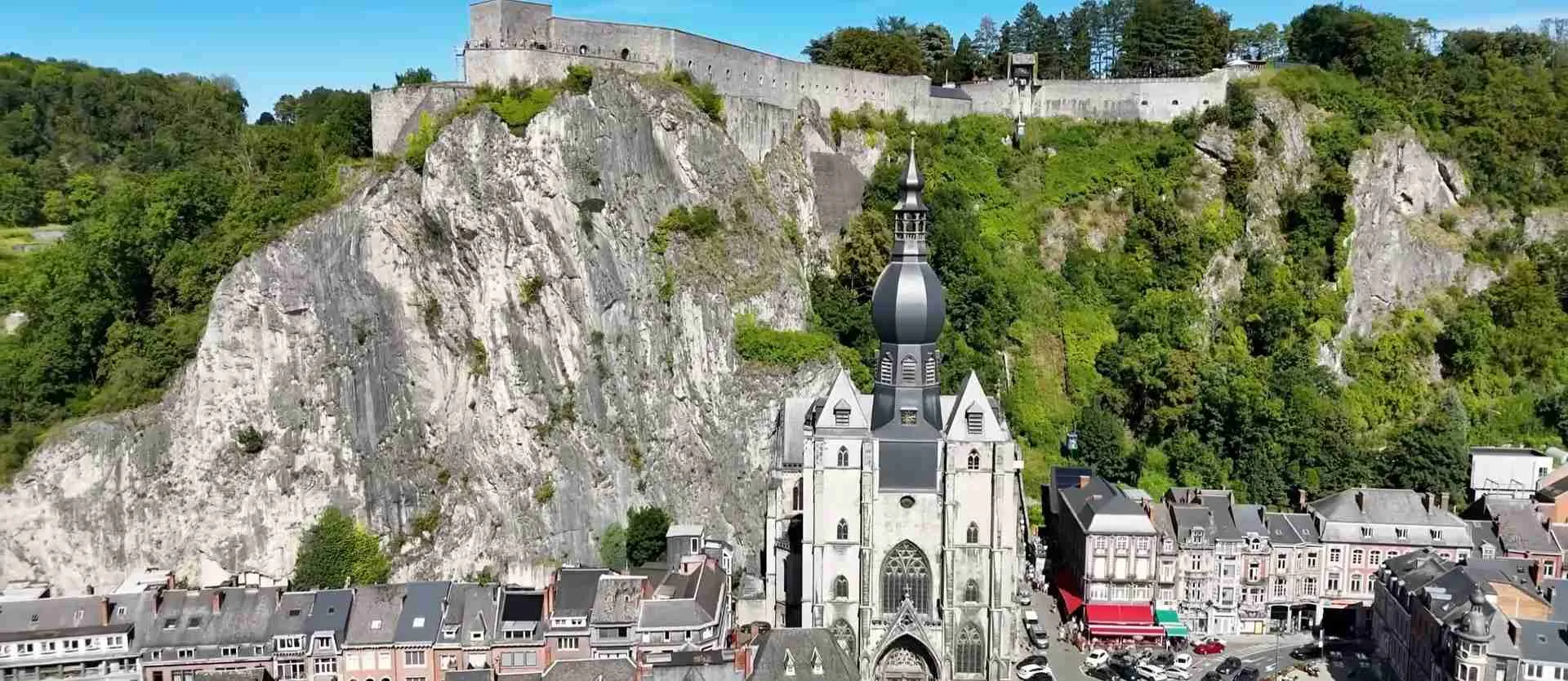
The Citadels of the Meuse: Analyzing the Limestone Military Engineering of Dinant and Namur
Rising from the limestone bluffs of the Belgian Meuse Valley, the citadels of Dinant and Namur represent two of Europe’s most instructive exercises in military engineering. Both fortresses exploit the dense Devonian and Carboniferous limestone of the Ardennes edge — a material that provided exceptional structural integrity alongside dramatic topographic advantage that no medieval or early modern army could easily overcome. Analyzing these two structures in parallel reveals an evolving tradition of defensive thinking shaped by geology, river hydrology, and several centuries of advancing siege technology.
Key Takeaways
- Geological Architecture: Both citadels exploit Devonian and Carboniferous limestone for construction and natural siting — a rock type of exceptional hardness that resists artillery impact far more effectively than brick and absorbs centuries of weathering with minimal structural compromise.
- Namur’s Layered Complexity: The Citadel of Namur is among Europe’s most complex fortification ensembles, encompassing three distinct structural zones — the medieval Château des Comtes, the Spanish-Habsburg Médiane, and the Dutch-era Terra Nova — unified by Vauban’s 1692 French reconfiguration into a coherent bastioned system.
- Dinant’s Vertical Drama: The Citadel of Dinant exploits a sheer limestone cliff rising approximately 100 metres above the Meuse, creating one of Western Europe’s most dramatically sited fortress positions where the rock face itself constitutes the primary defensive barrier on the river side.
- Vauban at Work: Sébastien Le Prestre de Vauban’s engineering principles are directly readable in the bastioned trace at Namur, where his 1692 siege and subsequent French reconstruction produced a textbook application of his angular defensive geometry against a complex historic promontory.
- Subterranean Engineering: Both citadels incorporate casemate systems and tunnel networks cut directly into the limestone bedrock, enabling garrisons to manoeuvre and position artillery below ground level during bombardment — a critical survival strategy in the gunpowder era that the hardness of the local stone made especially effective.
- Vauban vs. Coehoorn: The 1692 and 1695 sieges of Namur, pitting the two greatest military engineers of their age on the same ground, constitute one of early modern Europe’s most rigorously documented case studies in the mathematics of formal siege warfare.
People Also Ask About the Citadels of the Meuse
What type of limestone was used to build the Meuse Valley citadels?
The citadels of Dinant and Namur are built primarily from the Devonian and Carboniferous limestone of the Belgian Ardennes — a rock sequence partially named after Dinant itself, since the Dinantian Stage of the lower Carboniferous was named by 19th-century Belgian and French geologists for the limestone sequences exposed along the Meuse near Dinant. The dominant building material is a dense, hard calcite limestone characterised by its dark blue-grey colour caused by bituminous inclusions, commercially known as pierre bleue de Belgique or petit granit. Unlike softer limestone variants common in central France, the Meuse Valley stone achieves compressive strengths approaching granite in some formations, making it highly resistant to cannon impact — a critical property that elevated it above brick as a facing material in the gunpowder era. Quarries along the Meuse and in the wider region supplied primary ashlar for both citadels across multiple construction phases spanning the medieval period through to the Dutch reconstructions of 1817–1821.
How does the Citadel of Namur differ from the Citadel of Dinant in military engineering terms?
Namur is a compound fortification ensemble of considerable complexity, occupying a promontory at the confluence of the Sambre and Meuse rivers, with three distinguishable construction phases corresponding to medieval, Spanish-Habsburg, and Dutch-Williamist periods, all reconfigured by Vauban’s French fortification work of 1692. Its defensive strength relies on layered bastioned outworks, underground galleries, and the controlled flooding potential of two rivers. Dinant, by contrast, is a far simpler structure in plan but occupies a position of extreme natural strength — a vertical limestone cliff face that eliminates any approach from the river side entirely. Where Namur demonstrates the full analytical complexity of classical European fortification theory, Dinant represents the complementary principle that geology can achieve what engineering struggles to replicate: an impregnable vertical barrier that renders the attacker’s toolkit largely redundant from one entire flank.
What role did Vauban play in the fortification of Namur?
Vauban’s involvement at Namur came in two stages. In 1692 he directed the French siege that captured the citadel from the allied forces of William III of England, demonstrating the superiority of his systematic parallel-trench siege methods over the older direct assault tradition. Following the French capture, Vauban redesigned Namur’s bastioned trace and outworks to meet his demanding standards of defensive geometry. His most significant contribution was the rationalisation of the angular bastion system to eliminate dead ground — zones outside the defensive fire of the walls — while deepening the ditch complex and adding properly proportioned ravelins to protect the curtain walls. Namur thus became simultaneously a demonstration of Vauban’s offensive genius in 1692 and his defensive genius in the subsequent years of French occupation, before William III and Coehoorn recaptured it in the famous siege of 1695.
How did the geology of the Meuse Valley influence military strategy from medieval times onward?
The geology of the Meuse Valley determined military strategy across roughly a thousand years of conflict. The river cuts through Devonian and Carboniferous limestone to create steep, sometimes sheer valley walls that constrict movement to the riverbank itself, funnelling armies, supply wagons, and artillery along predictable corridors. The limestone promontories at Namur and Dinant convert this topographic constraint into decisive defensive positions — any force moving along the Meuse must pass directly beneath the walls of both citadels. The same stone that defined the landscape also prevented underground mining, one of the most destructive medieval and early modern siege techniques: limestone this hard makes sappers’ tunnels brutally slow and costly, giving defenders a substantial advantage against the classic mine-and-collapse attack. Into the modern era, the rock’s durability ensured that both citadels remained structurally viable long after brick fortifications of equivalent date had crumbled.
Extended multi-day tours – 5+ days
Featured Belgium Multi-Day Tour Packages

7 days
7 Day Brussels including Antwerp, Battle of the Bulge, Flanders Fields, Ghent, Bruges, Luxemburg & Dinant
- ✓ Comprehensive Belgium tour
- ✓ Expert local guides included
- ✓ All accommodation arranged
- ✓ Transportation provided

7 days
7 Days Across Paris & Brussels: From Eiffel Tower to Grand Place
- ✓ Comprehensive Belgium tour
- ✓ Expert local guides included
- ✓ All accommodation arranged
- ✓ Transportation provided

6 days
6 Days of Belgian Charm: Bruges, Ghent, Antwerp, Dinant & Luxembourg
- ✓ Comprehensive Belgium tour
- ✓ Expert local guides included
- ✓ All accommodation arranged
- ✓ Transportation provided

9 days
9 Days in Brussels and Luxembourg by Train: Fairytale Cities, Castles & Culture
- ✓ Comprehensive Belgium tour
- ✓ Expert local guides included
- ✓ All accommodation arranged
- ✓ Transportation provided
Multi-day tour packages powered by TourRadar. Prices and availability subject to change.
Introduction: Two Citadels and a Valley Defined by Stone
The Meuse River enters Belgium from France near Givet and immediately enters a landscape transformed by deep geological time. For roughly 90 kilometres between Dinant and Namur, the river has cut through the inclined limestone strata of the Ardennes edge, creating a valley of dramatic topographic contrasts: wide flood meadows at the valley floor, steep rock faces rising directly from the water, and flat limestone plateaux above. This landscape shaped human settlement patterns throughout prehistory and antiquity, but its military significance became definitive in the early medieval period when the combination of navigable waterway and defensible rock produced two of the most strategically positioned fortress sites in the Low Countries.
Dinant stands approximately 30 kilometres south of Namur, where the valley narrows dramatically between high limestone walls and the river bends sharply. The town occupies a thin strip of land between the cliff and the water; there is nowhere else to build, and the cliff directly above was the obvious, nearly obligatory location for any defensive structure. Namur, by contrast, sits at the confluence of the Sambre and Meuse — a point of such strategic value that it commanded not one river approach but two, while the promontory between them provided a naturally fortified position that the counts of Namur recognised and exploited long before systematic fortification theory existed.
These two sites are routinely discussed as separate tourist attractions, and separately they are certainly impressive. But the deepest understanding of each comes from analyzing them in relation to the other, because together they represent complementary answers to the same fundamental military problem: how to control movement along a major river valley using natural limestone terrain as the primary defensive resource. Namur solves this through complexity — multiple defensive layers, river control, underground systems, and continuous adaptation across a dozen successive rulers. Dinant solves it through geological simplicity — one sheer cliff, one narrow river, one overhanging wall of rock that does work no engineering can fully replicate.
This analysis examines both citadels in technical depth, tracing the interplay of geology, construction technology, fortification theory, and military history that made the Meuse limestone a decisive factor in European warfare from the medieval period through the First World War.
The Limestone Geology of the Meuse Valley: Architecture Before the Architect
Devonian and Carboniferous Formations: The Geological Foundation
The bedrock geology of the Meuse Valley between Dinant and Namur consists predominantly of sedimentary rocks deposited during the Devonian and Carboniferous periods, between approximately 410 and 300 million years ago. These rocks were laid down as marine sediments — carbonate muds, reef limestone, and shell-rich beds — in a shallow tropical sea that covered much of what is now northwestern Europe. Subsequent tectonic compression during the Variscan Orogeny folded and tilted these strata, and millions of years of erosion then stripped away overlying material to expose the tough limestone cores at the surface.
The lower sequence — the Famennian and Frasnian stages of the Upper Devonian — consists of grey and dark grey limestones alternating with shale horizons. Above these lie the Carboniferous limestones of the Tournaisien and Viséen stages, the latter named for the town of Visé further north on the Meuse. These rocks belong to the broader geological unit known internationally as the Dinantian — a term in widespread stratigraphy use named specifically for the outcrops around Dinant, which provided the reference exposures studied by Belgian and French geologists in the 19th century. The naming convention means that the very geology these citadels exploit contributed a major subdivision to global geological science. The Carboniferous limestone is harder, denser, and more uniform than the Devonian beds, and it is this material — particularly the massive pale-grey to blue-grey banks of the Viséen — that provided the primary building stone for both citadels.
The mechanical properties of this stone are exceptional by European standards. Compressive strength values for Belgian Carboniferous limestone (pierre bleue) regularly exceed 100 megapascals, making it comparable to medium-strength granite and dramatically harder than the softer limestones of Burgundy or the Île-de-France. This hardness had three military consequences: it made the rock extremely difficult to quarry by hand but extremely resistant once in place, it made mining operations by besiegers punishingly slow, and it absorbed cannon impact with a progressive crumbling behaviour rather than the catastrophic spalling that characterised softer stones and brick under artillery fire.
Structural Properties of Belgian Limestone in Military Construction
Military engineers working with Belgian limestone operated with a material of well-understood but demanding characteristics. Pierre bleue — known in administrative records as calcaire de Namur or calcaire des Croisettes depending on the specific quarry source — is a fine-grained, massive-bedded limestone with a characteristic dark blue-grey coloration imparted by dispersed bituminous carbon compounds. When freshly cut, the stone has a blue-black appearance that weathers over decades to a softer grey, and when polished it achieves a near-black lustre that made it one of the most prized decorative stones in Northern Europe from the Renaissance onward.
For military masonry, decoration was irrelevant. What mattered was that the stone could be quarried in large, clean-jointed blocks that resisted the freeze-thaw cycling of Belgian winters without progressive decay. The tight crystalline texture of the best beds resisted water infiltration, preventing the internal frost-shattering that crumbled softer sedimentary building stones. Early modern military engineers who tested brick versus limestone masonry against cannon fire found that while both materials shattered under direct hit, limestone fractured in larger, more stable fragments that maintained the structural coherence of the wall face longer than brick, which disintegrated into loose rubble under sustained bombardment.
These properties made pierre bleue the preferred facing material for the scarps — the vertical inner and outer walls of the defensive ditch — in the bastioned fortifications at Namur. Behind the limestone facing, construction practice evolved over the centuries from simple rubble fill to increasingly sophisticated systems using compacted earth and clay backed against the masonry. This earth-fill construction, standard in Vauban’s system, exploited the complementary properties of the two materials: the limestone face presented a hard, coherent surface to the attacker’s cannon while the earth absorbed the kinetic energy of penetrating shot, preventing the shockwave from destabilising the masonry backing.
The Meuse as a Geological Agent: River Incision and Defensive Topography
The dramatic cliff scenery at Dinant and the river confluence at Namur are both products of the Meuse’s progressive incision into the uplifted limestone plateau of the Ardennes. As the plateau rose tectonically during the Neogene period, the Meuse maintained its course by cutting downward through the rock at a rate that broadly kept pace with uplift. The result is an antecedent river system — one whose course predates the topography it currently traverses — that has produced vertically-sided gorges in the harder limestone formations and more open valleys where less resistant shales are exposed.
At Dinant, the river encounters a resistant Carboniferous limestone formation that plunges steeply into the valley. The Meuse has cut its way through this barrier but left sheer cliff faces on both sides, with the east bank cliff at the citadel site rising essentially vertically for approximately 100 metres from the river bank. This cliff is not a product of human quarrying or modification; it is a natural geological surface created by river undercutting and rockfall processes operating over geological time. The fortress builders at Dinant needed only to occupy this position: the geology had already created an impregnable vertical barrier on the riverside that no military engineering of the medieval or early modern period could hope to replicate artificially.
At Namur, the geological situation is less spectacular but strategically more complex. The Sambre enters the Meuse from the west at a slight angle, and between the two rivers lies a promontory of limestone that rises gradually from the Sambre bank but drops sharply toward the Meuse. The promontory is not a cliff in the Dinant sense — the slopes are steep but not vertical — yet its position between two rivers made it naturally defensible from the moment any organised military force appeared in the region. Even without walls, the promontory forced any attacker approaching from the west to cross the Sambre under fire, while an approach from the east required crossing the Meuse. The basic geology had already done the strategic thinking before any engineer laid out a single wall.
The Citadel of Namur: Engineering at the Sambre-Meuse Confluence
Gallo-Roman and Medieval Origins: Founding a Strategic Promontory
The promontory at the confluence of the Sambre and Meuse rivers attracted military attention long before formal fortification theory existed. Gallo-Roman settlement of the area is archaeologically attested, and while no major Roman defensive structure on the citadel rock has been conclusively identified, the strategic logic of the position was not lost on Roman commanders controlling the road network of Gallia Belgica. The medieval fortress on the rock emerges clearly from the historical record in the 10th and 11th centuries, when the Counts of Namur — a dynasty that held this county from the late Carolingian period until 1421 — began the systematic fortification of the promontory that became their seat of power.
The oldest structural element of the current complex, known as the Château des Comtes, occupies the western tip of the promontory and represents the most ancient continuous defensive core. Medieval construction here followed conventional practice: a combination of limestone rubble walls mortared with hydraulic lime, circular or rectangular tower elements at corners, and a great hall structure that served both residential and administrative functions for the comital household. The rock itself provided the foundation, and in several places the medieval builders incorporated natural limestone outcrops directly into the wall base, reducing both construction labour and the risk of differential settlement.
Through the 12th and 13th centuries, the Counts of Namur progressively extended the fortified perimeter as their political power grew. The Meuse side of the promontory was reinforced with curtain walls taking advantage of the steepest rock faces, while the Sambre approach — more gradually sloped and therefore more vulnerable — received additional tower elements. The fortress changed hands through inheritance and purchase: the County of Namur passed through Flemish and Burgundian successions until Philip the Bold of Burgundy acquired it from the last count in 1421. Throughout this period, the fundamental medieval character of the fortification was maintained, relying on high masonry walls and the natural strength of the rock rather than the angular bastion geometry that the gunpowder era would demand.
Burgundian and Spanish Habsburg Fortification: The Bastioned Transition
The arrival of effective siege artillery in the 15th and early 16th centuries forced a fundamental redesign of European fortifications. Vertical medieval walls, no matter how thick or tall, proved catastrophically vulnerable to cannon fire: a concentrated artillery battery could reduce a traditional curtain wall to rubble within days. The Italian response — developed by engineers including Francesco di Giorgio Martini and later members of the Sangallo family — was the trace italienne: a low, angled system of angular projections called bastions that replaced vertical walls with ramped earth and masonry surfaces deflecting cannon shot rather than absorbing it.
At Namur, the Burgundian period saw the first tentative responses to this new reality, but the systematic transformation of the citadel into a bastioned fortress came under Spanish Habsburg rule, which began with Charles V’s inheritance of the Low Countries in 1516. The Spanish military engineers who worked in the Low Countries throughout the 16th and 17th centuries — a tradition that produced some of Europe’s most sophisticated fortification work — progressively rebuilt the Namur defences on bastioned principles. The section known as the Médiane represents the primary Spanish-Habsburg construction phase, with angular bastions, demi-bastions at the corners, and curtain walls designed for flanking fire across the ditch rather than the direct overhead fire of medieval battlements.
The Spanish work at Namur was of high quality but faced an inherent problem: the limestone promontory’s plan shape was not ideal for regular bastioned geometry. Classical trace italienne design assumed a relatively flat site on which regular polygonal or irregular bastioned perimeters could be laid out on strictly mathematical principles. The Namur promontory’s elongated shape, tapering western tip, and irregular rock faces on the Meuse side forced the Spanish engineers into numerous compromises and adaptations, producing a fortification whose logic can only be fully understood by studying the underlying geology alongside the constructed elements. This productive tension between mathematical military ideal and topographic reality is visible in every historic plan of the Namur citadel and constitutes one of the most interesting features of its engineering analysis.
Vauban and the 1692 French Reconfiguration
The siege of Namur in June 1692 was one of the great military set pieces of the age of Louis XIV. The citadel was then held by a Dutch and Spanish garrison as part of the Grand Alliance against France, and its reduction was considered one of the most demanding possible tests of siege engineering given its reputation as the strongest fortress in the Low Countries. Vauban, then at the height of his powers and already the acknowledged master of European siege warfare, directed the French approaches with characteristic system and precision.
Vauban’s method, refined through dozens of sieges over decades, was the parallel approach: rather than advancing directly toward the wall in exposed zigzag trenches as earlier practice required, his sappers first dug a continuous trench parallel to the fortress face beyond effective musket range, then advanced toward the defences through angled zigzag approaches to a second parallel, and then a third at close range from which the final assault on the ditch could be prepared. This systematic progressive approach reduced casualties dramatically compared to earlier siege methods and made the eventual outcome of any siege mathematically predictable given sufficient time and materiel. At Namur, operating against a fortress with the full benefit of Spanish and Dutch engineering modifications, Vauban completed the investment and forced surrender in approximately five to six weeks — a demonstration that stunned contemporaries across Europe.
Having taken the fortress, Vauban immediately set to work redesigning it as a permanent French stronghold. His modifications concentrated on three areas: rationalising the bastioned trace to eliminate dead angles in the defensive fire, deepening and widening the ditch complex, and improving the covered ways and glacis that formed the crucial outer defensive zone. The bastions he redesigned display the characteristic Vauban proportion — a relationship between the lengths of bastion faces, flanks, and curtains that distributes defensive fire optimally across every section of the perimeter. The limestone scarps he rebuilt in pierre bleue ashlar, carefully battered (sloped slightly back from vertical) to increase structural stability under bombardment and to deflect cannon shot downward rather than transmitting its energy horizontally through the wall mass.
Coehoorn’s Countermeasures and the 1695 Recapture
The 1695 siege of Namur stands as the military-historical complement to Vauban’s 1692 victory. William III of England and his allied forces, including the great Dutch military engineer Menno van Coehoorn, invested the French-held citadel in the summer of 1695 and forced its surrender after a siege that, despite Vauban’s improvements to the defences, lasted only about two months — comparable in duration to the 1692 French attack despite the stronger works now in place.
Coehoorn was in several respects Vauban’s intellectual equal and in certain aspects his superior. His mortar — a lightweight, high-angle artillery piece designed for plunging fire into fortified positions — bore his name and became standard equipment in European armies for a century. His approach to siege warfare was more aggressive than Vauban’s systematic method, relying on faster advances and greater use of explosive bombs to neutralise the defenders before they could exploit the defences fully. The 1695 Namur siege became in European military literature the exemplary counter-demonstration that even Vauban’s best work could be overcome by a determined, well-equipped, and competently led assault that exploited new artillery techniques.
The detailed record of both sieges — approach trenches, battery positions, mining attempts, sortie repulses — survives in extraordinary documentary completeness, including Vauban’s own analysis of why the 1695 recapture succeeded. This documentation transformed Namur into a pedagogical site for European military thinking: the two sieges were analyzed in officers’ academies across the continent for the following century as case studies in the relationship between fortification design, siege technique, and tactical execution.
The Dutch Reconstruction: Terra Nova and the Final Military Form
Following the Treaty of Utrecht in 1713, the Austrian Netherlands received Namur, which remained under Habsburg control until the French Revolutionary Army captured it in 1794. After the Napoleonic period ended, the Congress of Vienna assigned the area to the newly created Kingdom of the Netherlands, and William I undertook a comprehensive reconstruction of the Namur citadel as part of his broader programme of border fortification along the southern frontier of his kingdom.
The Dutch reconstruction, executed between approximately 1817 and 1821 by engineers of the Corps of Military Engineers of the Kingdom of the Netherlands, added the substantial Terra Nova section to the eastern end of the complex. This section adopts a more regularised polygonal form than the earlier Spanish and Vauban work, reflecting the post-Montalembert evolution in fortification thinking that questioned aspects of Vauban’s bastion-heavy system in favour of simpler, cheaper tenaille traces and casemate artillery positions. The Terra Nova’s limestone masonry is the most recent major masonry construction on the site and displays the confident, clean ashlar technique that Dutch military engineering excelled in — regular courses, precise jointing, and carefully battered profiles on all scarps and counterscarps.
The complete Namur complex as it stands today therefore represents five distinct constructional periods: the medieval Château des Comtes, the Spanish-Habsburg bastioned extensions, the Vauban French modifications, the Coehoorn-influenced Dutch reinforcements of the late 17th and early 18th centuries, and the William I Terra Nova additions. Reading the site is an exercise in architectural stratigraphy: different quarry sources, different mortar compositions, different ashlar proportions, and different geometric principles are all visible in the masonry, making Namur arguably the richest single case study of European fortification evolution on the continent.
The Citadel of Dinant: Vertical Defense on the Sheer Cliff
Medieval Origins and the Bishop’s Fortress
Dinant’s cliff fortress sits on one of the most dramatic natural defensive positions in Western Europe — a sheer limestone cliff that rises approximately 100 metres directly from the bank of the Meuse, leaving no space between the rock face and the water for any significant approach or escalade. The town of Dinant occupies the narrow flood plain on the same bank, with the Collegiate Church of Notre-Dame squeezed between the cliff base and the river, its single asymmetric tower echoing the vertical drama of the rock above it.
The first documented fortification on the cliff dates to 1051, when the Prince-Bishop of Liège — who held political control over Dinant — established a defensive structure on the rock above the town. The bishopric of Liège was one of the great ecclesiastical territories of medieval Western Europe, and its southern marches along the Meuse were subject to constant pressure from the Counts of Namur and later the Counts of Hainaut. The cliff fortress was conceived primarily as a retreat position for the bishop’s garrison and a means of controlling the river — the commercially valuable Meuse, carrying trade between the Rhineland hinterland and the North Sea ports, passed directly beneath the walls, and any toll-collection or control of river traffic required command of the cliff above it.
The medieval structure on the cliff was constructed from the same Carboniferous limestone as the rock face itself, meaning that the distinction between natural geology and human construction was often difficult to discern at a distance — an unintentional visual effect that made the fortress appear more imposing and less accessible than it might otherwise have seemed. The extreme narrowness of the clifftop platform constrained the plan form severely: the fortress could never be more than a relatively shallow structure from front to back, with its length following the cliff edge and its depth limited by the plateau edge behind.
Burgundian Punishment and Reconstruction
Dinant occupies an unhappy place in Burgundian history. In 1430, Philip the Good of Burgundy subjected the town to a punitive military operation following civic unrest and resistance to Burgundian authority — a pattern the dukes applied to several of their Flemish and Walloon towns with considerable violence. The 1430 action was severe, but it was the 1466 intervention by Charles the Bold that entered lasting historical memory: Charles’s forces killed or expelled large numbers of the town’s inhabitants and effectively demolished much of the urban fabric of Dinant as an act of deliberate political terror.
The fortress above the town was repeatedly modified, destroyed, and rebuilt through these turbulent centuries. The Burgundian dukes had strategic reasons to maintain a defensible position at Dinant as a control point on the southern Meuse, but they had equally strong reasons to ensure that any fortress on the Dinant cliff remained firmly in their own hands rather than serving as a rallying point for local resistance. The construction history of the cliff fortress in the 15th and 16th centuries consequently reflects a cycle of demolition and reconstruction driven as much by political calculation as by military engineering progress.
Under Spanish Habsburg rule from 1516 onward, the fortress received improvements in line with the broader programme of bastioned fortification being applied across the Low Countries, though the extreme topographic constraints of the cliff site prevented the full application of regular trace italienne geometry. The Spanish engineers working at Dinant produced a more pragmatic solution: a series of wall sections, tower elements, and gate structures following the natural contours of the cliff top, with the sheer cliff face doing the work that bastioned outworks would have performed on a normal site. This pragmatism — choosing geological advantage over geometric orthodoxy — characterises the Dinant engineering tradition throughout its history.
The Dutch Rebuilding of 1818-1821
The current citadel structure at Dinant is almost entirely a product of the Dutch reconstruction of 1818-1821, carried out under the same William I programme that rebuilt Namur. This is a point of considerable historical irony: what visitors see today as an apparently ancient fortress is in reality a structure barely two centuries old, built to a simplified 19th-century military design that prioritises economy and practicality over the geometric sophistication of the Vauban tradition.
Napoleon Bonaparte had ordered the demolition of the previous fortress in 1815 after the Hundred Days and the final French defeat at Waterloo — a characteristic response to the symbolic and strategic threat of fortifications that might be used against French interests. The Dutch military engineers who replaced it worked with a reduced budget and a changed military context: the great era of formal siege warfare was already giving way to the mobile warfare of the Napoleonic model, and a traditional fortress on a cliff above a Belgian town had limited relevance to operations on the scale of the recent campaigns. The Dutch citadel at Dinant consequently adopts a simplified polygonal form rather than the complex bastioned geometry of Namur: a roughly pentagonal enclosure following the cliff edge, with angled wall sections, minimal outworks, and modest accommodation for the garrison.
The masonry is good quality pierre bleue limestone in regular ashlar courses, laid with tight lime mortar joints, but the ambition is firmly administrative and territorial rather than sophisticated military engineering. The structure was designed to be garrisoned, maintained, and used as a symbol of Dutch authority over the southern Meuse rather than to resist a serious systematic siege. The simplification compared to Namur is stark: where Namur displays centuries of accumulated engineering refinement, Dinant’s Dutch reconstruction is a single-campaign construction by competent but unhurried engineers who knew they were building a garrison fort, not a frontline defensive work.
Engineering Analysis: Integration with the Limestone Cliff Face
The true military engineering achievement at Dinant resides not in the constructed elements but in the exploitation of the geological context. The cliff face on the river side needs no wall: the vertical rock does the work of a perpendicular curtain wall hundreds of metres high, scaling which in any military period was effectively impossible under fire. The constructional challenge was rather to secure the clifftop perimeter against approach from the plateau side — the Ardennes plateau that forms the upper limestone exposure — and to control access via the extremely steep descent paths on the flanks.
Access to the citadel historically involved paths cut into the cliff face and a narrow staircase system — the steps carved into the rock face connecting the citadel gate to the level of the Collegiate Church below, numbering approximately 400 — that served the dual purpose of allowing garrison resupply and creating a controlled choke point through which any attacker from the town below would have to pass in single file under direct fire from the citadel walls above. No military engineer could have designed a better anti-escalade measure than this geological constraint enforced on any approach from the river bank.
The cliff face itself shows evidence of limited human modification at several points: cuttings, ledges, and anchor points carved into the limestone that supported scaffolding during construction phases, and in some areas, deliberate undercuts that prevented climbers from gaining purchase. The relationship between geology and engineering at Dinant is not the adversarial relationship often assumed — the military engineers did not impose their structures on a recalcitrant landscape — but a collaborative one in which the geological features were understood, respected, and systematically incorporated into the defensive system. The resulting structure has a coherent logic that only becomes fully apparent when the geological map and the plan of the fortification are read simultaneously.
Comparative Military Engineering: Namur and Dinant Analyzed
Strategic Positioning Principles at Both Sites
Both citadels conform to the fundamental principle of military site selection articulated by every major European fortification theorist from antiquity onward: command of the dominant ground, observation over the greatest possible distance, and control of critical lines of communication. At Namur, the dominant ground is the promontory between the rivers; the observation covers the approaches of both the Sambre and Meuse valleys; and the communication lines are the river crossings themselves, which any army moving through the region must use. At Dinant, the dominant ground is the cliff above the river; the observation covers the river valley for several kilometres in both directions; and the communication line is the river corridor that the cliff directly overhangs.
The critical difference is in the type of strategic dominance each site offers. Namur exercises active strategic dominance: its position at a river confluence means it can interdict movement along two river valleys simultaneously, and any army that bypasses Namur without capturing it faces a hostile garrison capable of threatening supply lines. Dinant exercises passive strategic dominance: it commands a single river corridor and can close it to river traffic, but its isolated cliff position means that a land army can move around it on the plateau above without necessarily confronting the fortress directly.
This difference explains the relative strategic importance assigned to the two sites across European history. Namur appears consistently in the records of every major military campaign that crossed the southern Low Countries — Roman, Merovingian, Carolingian, Burgundian, Spanish, French, Dutch, Austrian, and German forces all had to deal with Namur as a strategic obstacle. Dinant appears less consistently, important primarily in the context of Meuse trade route control and the Prince-Bishop’s territorial authority. In the great wars of the 17th and 18th centuries, Namur was the prize that both sides fought to hold; Dinant was a secondary position that mattered when control of the southern Meuse was in direct contest.
Bastioned Trace Versus Cliff-Top Polygonal Form
The contrast in plan geometry between the two sites encapsulates a broader distinction in European fortification theory between engineering-led and geography-led defensive design. Namur’s plan, for all its historical complexity, is fundamentally shaped by the logic of the bastioned trace: the angles of the bastions are calculated to provide flanking fire across every section of the curtain wall, the ravelins are positioned to protect the curtain wall gaps between bastions from direct fire, and the covered ways provide a defended communication route around the entire outer perimeter of the ditch. This geometry is primarily a product of military mathematics applied to the site, with the topography accommodated as best it can be.
Dinant’s plan is essentially a trace of the cliff edge with minimal geometric pretension. The walls follow the natural contours of the rock; the corner angles are determined by the cliff profile rather than by the mathematics of flanking fire; and the outworks that would characterise a bastioned fortification are absent because the cliff itself performs their function. This is not an inferior approach — it is a recognition that the geological context has already solved the problems that bastion geometry addresses on flat ground. The lesson of Dinant is that military engineering must begin with a rigorous reading of the landscape, and that the best engineer is often the one who recognises when nature has already done the essential work.
Comparative Scale and Garrison Requirements
The two citadels differ substantially in the scale of garrison they required to function effectively as defensive works. Namur’s complex system of bastions, outworks, ditch sections, underground galleries, and multiple defensive lines demanded a substantial garrison to man all positions simultaneously: an effective garrison for the full complex in its 17th-century form ran to several thousand men, supplemented by artillery crews for the numerous gun positions distributed across the bastioned perimeter. The total perimeter of the Médiane and Terra Nova sections alone extends to several kilometres — thinly distributing a small garrison across this extent risked leaving sections effectively undefended.
Dinant required a far smaller garrison precisely because its defensive geometry was simpler and its cliff-face natural protection eliminated the need to man positions that nature had already made inaccessible. A garrison of several hundred men, properly positioned at the clifftop perimeter and the approach staircase, could render the citadel effectively impregnable to any realistic assault from the town and river side. The plateau approach was more vulnerable and required more active defence, but the compactness of the structure meant that reinforcement from one section to another was rapid. This economy of garrison made Dinant a cost-effective defensive position in peacetime even when large standing armies were politically unavailable or financially unsustainable.
Vauban’s Principles and Their Expression at Namur
The Geometric Logic of the Bastioned Trace
To understand Vauban’s contribution at Namur fully, it is necessary to understand the mathematical logic that underpinned all bastioned fortification design. The fundamental problem that the bastion solved was the dead angle — the zone directly in front of a vertical curtain wall that lay outside the field of fire of defenders on the wall top. An attacker advancing toward a straight curtain wall section could take shelter in the ditch immediately at the wall base, in a zone that overhead defenders could not reach, and work there with pickaxes and crowbars (or later, explosives) without interference.
The bastion — a projecting angular element at the corner of the curtain wall, with two flanks facing back toward the adjacent curtain — solved this problem by placing artillery in the flanks that could fire along the face of the curtain and across the ditch immediately in front of it. The geometrical requirement was that every point on the curtain face should be in the line of fire of at least one bastion flank. This led to the characteristic proportioning problems of bastioned design — the relationships between bastion face length, flank length, curtain length, and the angle of the bastion gorge — that occupied military geometers from the 16th century onward and which Vauban resolved through systematic empirical testing and codification into formal design rules. The result was not a single prescribed form but a set of dimensional relationships that could be adapted to varying site conditions while maintaining the fundamental guarantee of complete defensive coverage.
At Namur, the existing Spanish bastions required adjustment to meet Vauban’s proportioning standards. The primary issue was that several earlier bastions had been built with faces and flanks of incorrect relative lengths, creating zones where flanking fire was insufficient. Vauban’s modifications involved the addition of secondary elements — orillons (curved projections sheltering the flank guns from direct counter-battery fire) and retired flanks (flanks set back from the bastion face to increase their protected observation angle) — that corrected these deficiencies without the enormous expense of rebuilding the bastion from scratch. This kind of systematic, minimal-intervention correction was characteristic of Vauban’s mature engineering style.
Outworks: Ravelins, Covered Ways, and the Glacis at Namur
The outer defensive zone of a Vauban-system fortress — the ravelins, covered ways, and glacis — constituted a defensive depth that was often more important to the fortress’s resistance than the main bastioned walls behind it. The ravelin, a triangular outwork positioned in the ditch gap between two adjacent bastions, had two functions: it protected the curtain wall behind it from direct artillery fire by intercepting enemy fire before it reached the curtain, and it provided forward gun positions from which flanking fire could sweep the approaches to the adjacent bastions. A correctly designed ravelin could double the time required for an attacker to breach the main wall behind it.
At Namur, the ravelins visible in 17th and 18th-century engravings and plans of the fortress represent one of the clearest applications of Vauban’s ravelin proportioning on any surviving site. The covered way — a sunken communication path running along the outer crest of the main ditch, connecting all the forward defensive positions — is cut at Namur partly through the natural limestone and partly through dressed masonry, creating a passage that allowed troops to move between bastions and ravelins under protection from enemy observation and fire. The glacis, the sloping open ground between the covered way and the surrounding countryside, was maintained as a cleared killing ground: any attacker advancing toward the covered way was exposed to fire from every forward defensive position simultaneously, with no cover available and no dead ground to exploit.
The physical presence of these outworks in the landscape of the Namur promontory is still perceptible today, though much was altered in the 19th century. The triangular shapes of former ravelin positions, the levelled berms of the glacis, and the traces of the covered way in the terrain surface provide a reading of the Vauban system that no plan or diagram can fully convey — these are spaces designed to kill attackers efficiently, and their geometry has a cold mathematical clarity that remains impressive three centuries after they were built.
Vauban Versus Coehoorn: A Siege Duel on the Same Ground
The juxtaposition of the 1692 and 1695 Namur sieges on the same site — first Vauban attacking, then Coehoorn attacking after Vauban had improved the defences — creates a rare natural experiment in early modern military history. Both engineers were working with the same basic siege methods, the same types of artillery, and the same fundamental terrain, yet each achieved success through subtly different applications of siege technique against a position each knew in detail.
Vauban’s 1692 approach exploited the river control that French forces achieved before the siege began: the Sambre and Meuse were both blockaded, cutting off resupply or relief to the garrison. With the fortress fully invested, Vauban opened parallels at a distance carefully calculated to be beyond effective cannon range from the walls, then advanced methodically to a second and third parallel before commencing his breaching batteries. The approach was slow by contemporary standards but achieved a steady mathematical reduction of the garrison’s defensive options: each forward parallel reduced the zone the defenders could occupy, increased the danger to their outlying positions, and brought the besieging artillery incrementally closer to effective breaching range.
Coehoorn’s 1695 recapture was faster and more aggressive, exploiting a larger force of superior mortars and a bolder willingness to accept higher casualty rates in the forward approaches. Coehoorn also benefited from detailed knowledge of the defences that Vauban had established — the same design that made the fortress harder for others to take also made its defensive layout comprehensible to a skilled analyst who knew the principles behind it. The mortar fire Coehoorn employed was specifically devastating in the traverses and casemates of the covered way, spaces that Vauban’s design had made resistant to direct artillery but whose curved vaulting provided only limited protection against plunging mortar shells. The lesson drawn in subsequent military literature was that fortification design optimal against one attack method could be vulnerable to another — a lesson that drove the continuous evolution of both offensive and defensive technique through the following century.
Construction Techniques and Masonry in Limestone Military Architecture
Quarrying and Dressing Local Limestone for Military Use
The construction of major limestone fortifications required the systematic exploitation of local quarry sources capable of producing the large, precise ashlar blocks demanded by military masonry standards. At Namur, multiple quarries were operated in the limestone exposures along the Meuse and Sambre valleys within practical haulage distance of the construction site. The selection of quarry beds was a technically demanding exercise: military engineers required stone free of major fracture planes, capable of being worked to precise dimensions with acceptable tool wear, and resistant to the delamination along bedding planes that freeze-thaw stress could cause in less competent beds.
The primary cutting tools for limestone ashlar were iron picks, saws, and wedge-and-feather systems. Large blocks were detached from the quarry face by drilling lines of holes along a natural bedding plane, driving iron wedges into the holes to propagate a controlled fracture, then undercutting the block with a pick to release it from the quarry bench. For military ashlar requiring close tolerances, the blocks were then dressed with a broad chisel and mallet to produce flat faces, followed by fine tooling with a drag or comb chisel to achieve the smooth-dressed surface finish visible in the surviving Vauban and Dutch-era masonry at both sites. The distinctive parallel fine-tooling marks visible on many blocks at Namur are a direct fingerprint of this final dressing operation, allowing trained observers to distinguish construction phases by tooling style alone.
The logistics of moving large limestone blocks from quarry to construction site were considerable. The availability of the Meuse and Sambre for water transport reduced costs substantially compared to land haulage — heavy stone could be rafted or barged along the river at a fraction of the cost of ox-cart transport over road. Evidence from military records of the 17th-century construction phases at Namur indicates that the bulk of stone was delivered by barge and unloaded at the riverside below the promontory, then hauled up the slopes to the construction site using crane-like lifting structures anchored to the existing masonry. The organisation of this supply chain was itself a major administrative achievement requiring the sustained coordination of quarry workers, river boatmen, carters, and the military construction teams on the site.
Wall Construction: Ashlar Facing, Rubble Core, and Earth Fill
Military masonry in the Vauban tradition was not solid stone throughout. The enormous thickness of the walls and ramparts required by the demands of resisting cannon fire made solid ashlar construction economically and practically impossible — the quantities of dressed stone would have been astronomical — and the structural behaviour of a solid stone wall under cannon impact was actually inferior to composite construction. The standard construction system used at Namur and replicated at Dinant combined three distinct structural components that worked together to resist artillery attack.
The outer and inner faces of the wall were built in ashlar limestone — carefully cut and laid blocks of pierre bleue in regular horizontal courses with tight mortar joints. These faces provided structural integrity, weather resistance, and the clean geometric surfaces required by military engineering standards. Behind the outer face, a core of limestone rubble — broken stone mixed with hydraulic lime mortar — filled the void to a depth of several metres, providing mass and resistance to cannon ball penetration. Behind the rubble core, and forming the largest part of the wall section in the Vauban system, was a compacted earth fill reinforced with clay layers. This earth fill was the critical energy-absorbing element, stopping cannon balls that had penetrated the masonry face and preventing the shock wave from destroying the inner face of the wall.
The scarps and counterscarps of the ditch were built in a slightly simplified version of this composite system, with the limestone ashlar face forming the primary visual and structural element and a less elaborate backing of rubble and earth. Vauban’s characteristic battered scarp profile — the slight inward slope of the wall face from base to top — served both structural and ballistic purposes: structurally, it provided a wider base and reduced the overturning moment of the wall under lateral earth pressure; ballistically, it caused cannon balls striking at the base of the scarp to ricochet upward and over the wall rather than penetrating and transmitting horizontal destructive force into the backing materials. The combined effect of composite construction and battered profile made the Vauban scarp considerably more durable under sustained bombardment than any earlier masonry system.
Vault Construction and Casemate Engineering
The casemate — a vaulted chamber within the body of a fortification, providing protected space for artillery, ammunition storage, or troop accommodation — was one of the most technically demanding elements of 17th and 18th-century military construction. The structural problem was formidable: the casemate vault had to support the full weight of the masonry and earth above it, resist the shock loads transmitted from cannon ball impacts on the outer walls, and prevent collapse under the explosion of shells bursting within the fortress perimeter. At Namur, where casemates were cut both from masonry and directly into the limestone bedrock, the solutions employed represent the most advanced casemate engineering practice of their period.
The masonry casemates at Namur use semi-circular barrel vaults in pierre bleue limestone, with the vault span carefully proportioned to the strength of the limestone arching. The characteristic vault span of around 3 to 4 metres allowed considerable interior height while keeping the vault haunches within a manageable thickness. The voussoirs — wedge-shaped arch stones forming the vault — are cut to precise geometric profiles ensuring uniform load distribution around the curve. The filling above the vault key was packed with rubble and then with compacted earth to a depth proportional to the expected impact load from above, effectively creating a cushioned burial for the casemate that protected it from direct hits while limiting the weight the vault had to carry in its resting state.
Where casemates were cut directly into the limestone bedrock — particularly in the tunnel networks of Namur — the geological properties of the pierre bleue became a direct structural asset. The self-supporting capacity of the rock, which could maintain stable tunnel openings of 3 to 4 metres in span without any masonry lining where the rock was relatively unfractured, reduced construction costs enormously. The tunnel engineers drove a pilot heading through the rock, assessed the structural behaviour, and only lined sections where fracturing or poor rock quality made masonry support necessary. The result was a tunnel system of mixed construction — rock-cut where the geology was competent, masonry-lined where it was not — that achieved a high strength-to-cost ratio across a large total tunnel length.
Subterranean Military Engineering: The Underground Dimensions
The Tunnel Networks of Namur: Scale and Purpose
The underground works at Namur represent one of the most extensive subterranean military engineering achievements in Northern Europe — several kilometres of interconnected tunnels, chambers, and casemates cut primarily through the limestone bedrock of the promontory. These works were not created in a single construction phase but accumulated over centuries, with each successive military power that held the citadel adding to, modifying, or extending the existing network.
The medieval counts of Namur likely began the subterranean element with simple rock-cut chambers used for storage and water cisterns — the basic provision of any well-equipped medieval fortress. The Spanish Habsburg military engineers substantially extended the underground works as part of the general transition to gunpowder warfare: underground magazines were essential in the age of firearms, and the natural protection of deep rock made the Namur promontory ideal for substantial powder magazine construction. Vauban’s modifications added connecting communication tunnels that allowed troops to move between different sections of the underground network without exposure to the surface, and the Dutch reconstruction of 1817-1821 added further regulated tunnels and casemates in the eastern Terra Nova section.
The functional purposes served by the Namur tunnels were multiple. Powder magazines occupying the deepest sections provided the safest possible storage for the enormous quantities of gunpowder that a fortress artillery park required — a single accidental ignition in an exposed surface magazine could destroy an entire fortification, as European military history demonstrated with terrible regularity. Protected communication passages allowed garrison commanders to reinforce threatened sections of the perimeter without exposing troops to the devastating artillery fire that swept open ground during a siege. Underground gun chambers provided positions from which flanking fire could cover the ditch without placing artillery crews in the exposed bastion flanks above ground.
Counter-Mining and the Role of Hard Limestone in Defense
Mining — the technique of digging tunnels beneath a wall or bastion to collapse the foundation by burning timber supports in a charge chamber — was one of the most feared and effective siege techniques from the medieval period through the 17th century. A well-executed mine could collapse an entire bastion in minutes, creating a breach large enough for infantry assault before the defenders could organise a response. The counter-measure was counter-mining: the defenders dug their own tunnel network toward the enemy’s mining operations, attempting to break through into the enemy tunnel before it was complete and either destroying it or killing the enemy miners.
The hard Carboniferous limestone of the Namur promontory provided a substantial natural counter-mining advantage. Driving a mining tunnel through pierre bleue required heavy iron picks, experienced miners, and several weeks of work even for a limited tunnel length — the stone’s compressive strength made rapid progress impossible. The rock’s hardness also meant that it tended to fall in large blocks rather than collapsing progressively when the mine charge was fired, making the collapse geometry less predictable and reducing the likelihood of a clean, breach-producing collapse compared to softer geological environments. At several points in the documented history of Namur’s sieges, mining attempts were recorded as abandoned or redirected because progress through the limestone was too slow to maintain operational viability.
The defenders exploited this natural advantage through their established tunnel network: galleries were maintained at depths within the promontory that would intercept any enemy mining approach from the ditch. Listening posts — chambers where soldiers could press their ears to the rock and detect the vibrations of enemy pick work — were positioned at the ends of these counter-mine galleries, providing early warning of mining attempts. The combination of hard rock and an established tunnel network made Namur significantly more resistant to mining than it would have been on a softer geological substrate, and it is no accident that the successful sieges of both Vauban and Coehoorn were accomplished by artillery and systematic approach rather than by mining the bastions.
Underground Artillery Platforms and Magazines
One of the most sophisticated applications of subterranean military engineering at Namur was the underground casemated artillery position — a chamber cut into the rock or masonry, provided with a gun embrasure opening through the scarp face, from which artillery could fire into the ditch or along the curtain wall without exposing the gun crew to return fire from enemy battery positions. These positions combined the rock-cutting and masonry-vaulting skills of the construction engineers with the metallurgical capabilities required to produce cannon of sufficient compactness for operation in confined underground spaces.
The technical demands of underground artillery platforms were considerable. The embrasure opening through the scarp face had to be sized and angled to provide the required field of fire while minimising the visible opening available to enemy sharpshooters. The vault overhead had to resist the shock of the gun’s own discharge — a problem not present in surface battery positions — requiring additional thickness or reinforced construction. The ventilation of the chamber was critical: gunpowder smoke in a confined space could incapacitate the gun crew within minutes unless adequate ventilation passages were maintained, and the design of these passages without compromising the defensive integrity of the chamber walls required careful engineering judgment.
The underground magazines at Namur achieve their most impressive scale in the sections designed for powder storage in the 17th-century modifications. A major fortress could consume thousands of barrels of gunpowder in a sustained siege, and storage at temperatures and humidity levels that prevented premature deterioration was a major operational requirement. The natural temperature stability and low humidity of deep limestone rock — maintaining approximately constant cool temperatures year-round in the deep chambers — made rock-cut magazines superior to any surface construction, and the Namur powder stores occupied chambers of substantial volume deep within the promontory where they were safe from all but the most precisely aimed plunging artillery fire.
The Meuse as Defensive Architecture: River Integration
Controlling the River Crossing: Strategic Implications of River Confluences
The confluence of the Sambre and Meuse rivers at Namur is not merely an aesthetic feature of the landscape; it is the fundamental strategic fact that determined the site’s importance across two millennia. A river confluence is simultaneously a transportation node — where two waterways meet, trade and movement naturally concentrate — and a defensive bottleneck, because any land force moving through the region must either cross both rivers or find a route that avoids them, and the citadel promontory between the rivers controls the most natural crossing point for both.
In the pre-modern military period, before the widespread use of pontoon bridging, crossing a major river was a logistically demanding and tactically vulnerable operation. Crossing two major rivers in sequence, while a hostile garrison on the promontory between them fired on the crossing with artillery and small arms, raised the difficulty to an entirely different level. The Namur citadel did not merely threaten an army that ignored it — it made any army’s progress through the region essentially impossible without first reducing it. This is why Namur features in virtually every major military campaign in the Low Countries: it was not a strategic option but a strategic necessity that every commander had to address.
The river also provided logistical support to the fortress itself. River-borne supply — food, ammunition, and reinforcements delivered by barge — was substantially cheaper and more reliable than land transport and could continue under conditions that made road movement difficult or impossible. Control of the river meant control of the primary supply line for the fortress, which is why every major siege of Namur began with operations to blockade the rivers above and below the city before the approach trenches were opened against the walls.
Flooding as a Defensive Weapon at Namur
The presence of two rivers beside the Namur citadel created an additional defensive resource that the Spanish and later engineers exploited systematically: the inundation of the low ground around the promontory by controlled flooding of the Sambre. The Sambre’s relatively flat flood plain to the west of the promontory could be flooded by damming the river and diverting water across the plain, creating a shallow but extremely difficult obstacle across the primary land approach to the fortress.
Controlled inundation was a standard feature of Low Countries fortification from the medieval period onward, used extensively by Dutch engineers in the defence of the Netherlands against Spanish, French, and other forces. The technique required the construction of sluice gates at key points in the river bank and canal systems, allowing the garrison to raise or lower water levels rapidly in response to operational needs. At Namur, the combination of natural river flooding potential and constructed sluice works created inundation capability on the Sambre side that substantially complicated the attack geometry: approaches practicable in summer dry conditions became impassable marshland when the sluices were opened in autumn or winter with the river running high.
Both Vauban’s 1692 siege and Coehoorn’s 1695 siege had to account for this flooding capability in their approach planning. Vauban, attacking in summer when the risk of spontaneous flooding was lower, was able to operate his approach trenches on the Sambre plain without major inundation interference. His planning documents show that he identified the flooding risk and timed his opening of the approaches to exploit the summer low-water period before autumn rains could raise the Sambre to inundation levels — one more demonstration of the methodical environmental intelligence that characterised his siege operations.
The River at Dinant: Constricted Valley and Tactical Advantage
The Meuse at Dinant serves a different defensive function than at Namur. Rather than providing an inundation resource or creating a two-river crossing problem for attackers, the Meuse at Dinant serves as a straightforward barrier that, combined with the cliff above it, eliminates an entire approach sector from the tactical problem. The river at this point in the valley is not exceptionally wide — perhaps 80 to 100 metres — but the combination of water and cliff makes the eastern approach to the town militarily equivalent in difficulty to a formal fortification on flat ground.
The tactical consequence is that any military force attacking Dinant must approach from either north or south along the valley floor, where the river and cliff constrain movement to a narrow corridor, or from the plateau above, where the citadel’s clifftop position provides observation and fire over all routes from the Ardennes plateau. This three-quarter encirclement of difficult ground means that an attacker has no good option: the valley approaches are narrow and exposed, while the plateau approach faces the citadel directly. The river did not need to be dammed or manipulated; it needed only to exist in its geological position, and the narrow valley created by millennia of river incision through limestone did the rest.
This passive defensive function of the river explains why Dinant repeatedly held out against forces that might numerically have been expected to overwhelm it: the constriction of the valley limited the frontage on which any attacking force could deploy, preventing the numerical superiority of the attacker from translating into tactical advantage. A garrison of a few hundred men holding a narrow valley access against an army of thousands was an entirely viable proposition at Dinant in a way it would not have been on open ground, and this valley-constriction effect was as much a product of geology as of any human engineering.
Military Testing: The Citadels Under Fire
The Great Sieges of Namur: 1692 and 1695
The two great sieges of Namur in the 1690s represent the peak of the citadel’s military significance and the most rigorous test of its engineered defences. In 1692, Louis XIV of France personally attended the siege — a statement of symbolic as well as military intent — while Vauban directed operations. The garrison, commanded by experienced Dutch and German officers, made full use of the defensive works: sorties from the covered way harassed the French approach parties, the underground magazines maintained the powder supply throughout the extended investment, and the bastioned outworks made the French pay dearly for every metre of approach trench advanced.
The French success after approximately five to six weeks of formal siege operations validated Vauban’s system not through any dramatic coup but through the inexorable mathematical advance of the parallels and batteries. When the third parallel had been completed and the breaching batteries opened at close range on the selected bastion, the garrison’s situation became untenable: a breach was made in the curtain, the counterscarp was taken, and the garrison negotiated a honourable capitulation before the final assault was delivered. The result confirmed the dominant lesson of 17th-century siege warfare: no fortress, however well-designed, could hold indefinitely against a properly equipped and properly commanded besieger with sufficient time and resources. Strength of fortification translated into time gained, not into immunity.
The 1695 recapture under William III and Coehoorn demonstrated that the same lesson applied to Vauban’s own improvements to the defences. Coehoorn’s faster, more aggressive approach exploited a larger mortar park that suppressed the defenders in the covered ways and created conditions for a more rapid advance than Vauban’s careful system had required. The speed of the 1695 recapture, achieved in a broadly comparable timeframe to the 1692 attack despite the stronger French defences, suggested that the offensive-defensive balance in siege warfare was shifting: improvements in bombardment technology were outpacing the ability of fortification design to compensate, a dynamic that would ultimately drive the most sophisticated 18th-century fortification theories toward ever-deeper underground works and ever-more-complex outwork systems.
Dinant in the Wars of the Low Countries
Dinant’s military history before the Dutch reconstruction is characterised by cycles of attack and surrender driven more by political context than by the strength or weakness of its defences. The fortress itself, in its various pre-1815 forms, was never taken by the kind of systematic formal siege that Namur endured: its principal vulnerability was not to military engineering but to political isolation, when the overlord who held it could no longer maintain a garrison or resupply it across the plateau routes that connected the cliff fortress to its hinterland.
The Burgundian interventions of 1430 and 1466, devastating as they were to the town of Dinant, were primarily punitive operations against the civic population rather than systematic military operations against the fortress. Charles the Bold’s forces in 1466 employed artillery bombardment against the town buildings and the lower defensive works, but the sheer cliff appears to have rendered any attempt at a formal breach impractical. The result was a forced capitulation through blockade and the credible threat of total destruction rather than through military engineering defeat — the cliff’s protection was absolute against direct assault but could not prevent starvation or the political collapse of the defending authority.
This pattern of resistance-by-position-without-engineering-defeat recurs across Dinant’s military history. The fortress changed hands repeatedly but was rarely taken by force: the political or logistical situation of the defending garrison deteriorated to the point where resistance became pointless, and a negotiated surrender preserved the lives of the garrison at the cost of the fortress. This outcome was entirely predictable from a military engineering perspective: the position was too strong for direct assault but too small and isolated to maintain resistance against a prolonged blockade by a major power with the patience to wait out the garrison’s supplies.
World War I and the Belgian Fortifications of the Meuse
The First World War brought both citadels back into the context of active military operations, though in circumstances radically different from the siege warfare they had been built to resist. By 1914, the Vauban-era fortifications at both Namur and Dinant had been superseded as primary defensive works by the ring of modern concrete and steel forts that Belgium had constructed in the late 19th century under the engineer Henri Alexis Brialmont. The Namur position was ringed by nine modern forts — concrete structures with retractable gun turrets designed to resist the heaviest artillery then expected — that constituted the primary Belgian defensive line on the Meuse. The historic citadel on the promontory had no meaningful role in the August 1914 fighting.
The Brialmont ring forts at Namur were reduced in a matter of days by German artillery, including heavy siege howitzers that proved devastatingly effective against the Belgian concrete constructions. The performance of the Namur forts in August 1914 confirmed what military analysts had privately acknowledged for decades: the progressive increase in artillery calibre and explosive power had rendered fixed fortification of any period essentially untenable against a major power’s siege train. Even the most sophisticated 19th-century concrete and steel construction was no match for the 420mm Krupp howitzers and 305mm Skoda mortars deployed against it — weapons that made the entire three centuries of Vauban-tradition masonry fortification equally irrelevant in a single campaign.
At Dinant, the military events of August 1914 were of a different and darker character. German forces of the Meuse Army crossed the river on August 23, 1914 under fire from Belgian and French defenders on the western bank. In the process of securing the town and suppressing what German commanders characterised as civilian resistance — the precise events and their interpretation remain contested by historians — German soldiers executed approximately 674 civilians in what became known as the Dinant massacre, one of the largest single atrocities against civilians in Western Europe during the First World War. The citadel above watched over a town devastated not by siege warfare but by the new character of industrial-age conflict.
The Legacy of the 1914 Campaigns
The First World War events along the Meuse demonstrated with brutal clarity the obsolescence of the stone fortification tradition that had defined European military architecture for three centuries. The limestone walls and bastioned geometries of Namur and Dinant, however impressive in their historical context, played no part in the 1914 operations beyond providing observation posts and administrative accommodation. The military significance that had shaped these sites across a millennium was dissolved in a matter of weeks by the scale and technology of industrial warfare.
This historical punctuation gives the two citadels a peculiar quality for the analytical visitor: they are both the products of a living military tradition, built to specifications that represented the cutting edge of defensive engineering in their respective periods, and simultaneously monuments to the technological threshold that rendered that entire tradition obsolete. The limestone bastions that Vauban calculated so carefully to defeat 17th-century siege artillery were as irrelevant to 420mm howitzers as a medieval curtain wall had been to Vauban’s own breaching batteries. Each generation’s engineering solution became the previous generation’s museum exhibit, and the Meuse citadels now carry the accumulated strata of that progression in their very masonry.
The Second World War returned German forces to the Meuse Valley in 1940 and again in the winter of 1944-45 during the Battle of the Bulge, when the Ardennes plateau above Dinant and Namur became the scene of the last major German offensive on the Western Front. The historic citadels served as observation posts and headquarters locations — their commanding positions above the valley remained militarily useful even when their masonry served no defensive function. This residual utility, divorced from all the engineering logic that produced the structures, was perhaps the final irony of the long military history of the Meuse limestone fortifications.
Conservation and the Challenges of Historic Limestone Masonry
Weathering Mechanisms in Belgian Limestone Fortifications
The pierre bleue limestone of the Namur and Dinant citadels presents a distinctive conservation profile compared to softer limestone building materials. Its high density and low porosity give it good resistance to surface dissolution and the frost-related spalling that destroys softer stones, but several weathering mechanisms specific to the Carboniferous limestone environment create significant long-term challenges for the maintenance of historic masonry.
The most important weathering process affecting the citadel masonry is sulfate attack: dissolved sulfur dioxide from industrial and traffic-source air pollution reacts with calcite in the stone surface to produce gypsum (calcium sulfate), which has a larger molar volume than the calcite it replaces. This volume change creates internal stresses that gradually detach the stone surface as thin shells or spalls — a process known as contour scaling. The dark bituminous content of pierre bleue, while providing its characteristic colour, creates a stone surface with higher chemical reactivity at the microscopic scale than pure white limestone, potentially increasing the rate of surface reaction over long exposure periods.
A second significant mechanism is the corrosion of iron cramps and ties embedded in the historic masonry. Both the Vauban-era and Dutch-era construction at Namur incorporated iron fixings — dowels, cramps, and anchors connecting ashlar blocks or securing structural elements — that have been progressively corroding over two to three centuries. The corrosion products occupy considerably more volume than the original iron, creating expansive forces within the stone that crack and dislodge blocks. This mechanism is acute in the Belgian climate, where high annual rainfall ensures that iron fixings remain wet for much of the year, sustaining the oxidation reaction at rates that over the span of centuries produce visible cracking and dislodgement in affected courses.
Contemporary Conservation at Dinant and Namur
Both sites are maintained as open-access heritage attractions, with Namur’s citadel managed by the Wallonia Region and Dinant’s citadel under municipal management with regional support. The conservation approach at both sites reflects contemporary European heritage principles that prioritise minimal intervention, reversibility of treatment, and the preservation of authenticity over comprehensive restoration aimed at producing a single historical period appearance.
At Namur, priority conservation activities focus on structural stabilisation of the underground tunnel network — the most complex and potentially dangerous element of the site — and the maintenance of the exterior masonry surfaces against progressive sulfate weathering and frost damage. Sections of the underground galleries are periodically closed for assessment and consolidation work, with rock bolt stabilisation and shotcrete reinforcement applied where the original stone vault is showing signs of progressive loosening. Above ground, cleaning and consolidation treatments using compatible lime-based mortars have been applied to sections of the scarp and counterscarp masonry showing the most active deterioration. The challenge of maintaining internal consistency across five distinct construction phases, each with its own mortar composition and ashlar character, requires careful material analysis before any repair intervention.
At Dinant, the conservation focus is primarily on the 19th-century Dutch masonry, which, while structurally sound in most areas, shows progressive mortar joint deterioration and differential settlement cracking in sections where cliff-edge foundation conditions have not remained stable over two centuries. The cable car access structure — a 20th-century addition — has been managed to minimise its visual impact on the historic citadel profile while maintaining the visitor access that makes the site economically viable for conservation investment. The cliff face below the citadel walls is regularly inspected for rockfall hazard, and sections showing active weathering have been secured with rock netting to prevent dislodgement of blocks onto the town below — a safety requirement that adds a new layer of management complexity to an already geologically demanding site.
Archaeological Research and Ongoing Discoveries
Both sites support ongoing archaeological research that continues to refine understanding of their construction history and usage patterns. At Namur, systematic mapping and documentary recording of the underground tunnel network — a project conducted in phases over several decades — has revealed sections of earlier construction buried within later modifications, including rock-cut chambers that appear to be medieval features incorporated into the Spanish-period underground works. Ground-penetrating radar surveys of the promontory surface have identified buried wall foundations in areas where surface masonry has been removed, suggesting that the extent of the historic fortification complex is larger than visible above-ground remains indicate, and that several construction phases previously known only from archival sources have physical traces still present beneath the surface.
At Dinant, archaeological investigation has been more limited due to the restricted site area, but analysis of the standing Dutch-period masonry has identified at least two distinct construction phases within what was previously considered a single homogeneous build campaign of 1818-1821. Differences in quarry source, mortar composition, and ashlar tooling marks between sections of the main enclosure wall suggest that construction proceeded more episodically and with more variation in contracting and sourcing than the official administrative records acknowledge. Small-scale excavation at the base of the cliff-face wall junction — the meeting point between the constructed fortification and the natural rock — has recovered medieval metalwork and ceramic fragments consistent with earlier occupation of the cliff top, confirming the documented 11th-century origins of the site despite the absence of visible medieval masonry above ground. Each excavation season adds detail to a construction chronology that archival sources alone could never fully resolve.
Frequently Asked Questions
Are the Citadels of Dinant and Namur UNESCO World Heritage Sites?
Neither the Citadel of Dinant nor the Citadel of Namur holds individual UNESCO World Heritage Site designation, though both are protected as major heritage monuments under Belgian and Walloon regional legislation. Belgium’s UNESCO World Heritage List includes several sites in the Wallonia region — among them the four hydraulic boat lifts on the Canal du Centre, the Neolithic flint mines at Spiennes, and the Cathedral Notre-Dame in Tournai — but the Meuse citadels have not been put forward for World Heritage nomination. Both sites are recognised under the Belgian system as monuments classés, affording them legal protection against demolition, unsympathetic alteration, and inappropriate development in their immediate settings. This protection status is a reflection of their acknowledged significance as major examples of European military architectural heritage.
What is the best way to visit both citadels on the same trip?
The two citadels are approximately 30 kilometres apart along the Meuse Valley, a distance easily covered by car in 30 minutes or by regional train with a change at Dinant station. A logical itinerary allocates a full morning to Namur’s more complex citadel complex — the underground galleries and the multiple distinct construction phases reward extended exploration — and an afternoon to Dinant, where the cable car ascent, the citadel itself, and a walk through the town require about two to three hours. The train journey between the two, following the Meuse valley, provides a continuous visual context for the geological and topographic observations in this analysis: the progression from the open valley near Namur to the narrowing gorge landscape at Dinant is one of the most instructive geological transects in the Belgian Ardennes.
How long did it take to construct the Dutch-era citadel at Dinant?
The Dutch reconstruction of the Dinant citadel was carried out between 1818 and 1821, a construction period of approximately three years. This relatively rapid completion was possible because the Dutch engineers adopted a simplified polygonal plan form rather than the complex bastioned geometry that earlier structures had employed, requiring substantially less precision masonry work and fewer specialist engineering decisions. The available pierre bleue limestone could be quarried locally and hauled to the cliff top using the established paths and lifting equipment inherited from centuries of earlier construction activity on the site, and the Dutch military construction corps was experienced in rapid fortification work developed through the intensive engineering activity of the Napoleonic period. The speed of construction also reflected the reduced military ambition of the project: this was a garrison fort marking territorial authority, not a frontline defensive work designed to withstand a formal siege.
What is the Dinantian and why is it named after Dinant?
The Dinantian is a series in European stratigraphy corresponding to the lower Carboniferous Period, approximately 358 to 330 million years ago. It was named by 19th-century Belgian and French geologists for the limestone sequences exposed around Dinant on the Meuse, which provided the reference outcrops — the type locality — for these formations in the scientific literature. The name has been retained in widespread international usage, meaning that the town of Dinant has contributed not only its name to a specific local rock type but to a formal geological time division used by geologists worldwide. This nomenclature history is one of the more remarkable intellectual legacies of the Meuse Valley limestone, speaking to the quality, distinctiveness, and scientific importance of the rock sequences that determined the military geography of this valley across a thousand years of conflict.
How thick were the walls of the bastioned citadel at Namur?
Wall thicknesses at the Namur citadel varied considerably depending on the construction period and the structural purpose of the particular element. Medieval curtain walls in the Château des Comtes section are typically 1.5 to 2.5 metres thick — substantial by medieval standards but inadequate for resisting gunpowder artillery. The Spanish-Habsburg and Vauban-era bastioned masonry scarps are considerably more massive: bastion faces are typically 3 to 5 metres thick in masonry alone, with additional earth backing that increases the total effective wall thickness to 10 to 15 metres or more at the rampart level. The underground casemate vault walls are typically 1.2 to 1.8 metres thick, providing significant protection against indirect artillery hits while maintaining practical interior dimensions for artillery operation and troop accommodation.
Could either citadel withstand modern military attack?
Neither citadel was designed to resist the artillery systems that became standard from the mid-19th century onward, and both were effectively obsolete as serious military works before the First World War. The Belgian military recognised this and built the ring of modern Brialmont forts around Namur in the 1880s rather than investing further in the historic citadel. Against modern precision-guided munitions, explosive charges, and air-delivered weapons, no masonry fortification of any period could function as a meaningful military obstacle. The citadels retain value as observation positions, command posts, and protected accommodation within a military context — German forces used both sites for exactly these purposes in both World Wars — but their era as primary defensive works ended definitively in the era of rifled artillery and industrial-age explosive shells, which rendered masonry fortification of all types irrelevant to serious military operations.
What architectural features distinguish the Vauban-era masonry from earlier construction at Namur?
Vauban-era masonry at Namur can be distinguished from earlier construction by several diagnostic features. The ashlar courses are more precisely dimensioned and more uniformly coursed than Spanish-Habsburg work, with joint widths typically under 10 millimetres — a product of Vauban’s insistence on high masonry standards as a precondition for the geometric precision his designs required. The batter of the scarp face is more consistently applied than in earlier work, giving the Vauban-era walls a characteristic lean that differs visually from the more upright medieval and early Renaissance sections. Orillon elements — the curved shoulder projections at bastion angles that shelter the flanking gun positions — are a diagnostic Vauban addition absent from earlier Spanish bastions. The mortar composition of Vauban-era construction typically includes pozzolanic additives that produce a harder, less soluble set than the purely calcium hydroxide mortars of earlier construction phases.
Why was the Meuse Valley so persistently contested in European military history?
The Meuse Valley’s persistent military importance derives from its function as the primary overland and waterway corridor connecting the Rhineland heartland of the Holy Roman Empire with the North Sea coastal cities of Flanders and the Netherlands. Any power seeking to control trade between the Rhine and the North Sea — or to project military force between France and the Low Countries — had to manage the Meuse corridor. The river’s navigability for substantial barge traffic from Verdun to the sea made it not only a strategic line of communication but an economic artery whose control translated directly into fiscal power. The citadels at Namur and Dinant were not built in isolation; they were the physical expression of a persistent geopolitical logic that made the Meuse Valley strategically important from the earliest settled period through to the 20th century, when the same corridors that carried Burgundian and Spanish armies carried German panzer columns in 1940 and 1944.
How did the underground galleries at Namur affect garrison survival during sieges?
The underground galleries substantially enhanced garrison survival capacity during the 1692 and 1695 sieges by providing protected movement routes, ammunition storage, and rest areas that allowed the garrison to maintain effective resistance even while surface positions were under continuous artillery bombardment. Historical records of both sieges note that besieging forces’ batteries were unable to suppress the defenders entirely, because garrison troops could shelter in the underground system during intense bombardment and re-emerge to man the wall positions as attacking infantry advanced. The ability to protect powder magazine stores in deep rock-cut chambers was particularly critical: several other 17th-century fortresses were forced to capitulate early when lucky artillery strikes ignited surface magazines, causing catastrophic explosions that destroyed entire bastions in seconds. At Namur, the deep underground magazines were effectively invulnerable to this threat, maintaining the garrison’s fighting capacity throughout the siege investment.
What is the Roche Bayard and how does it relate to the military landscape of Dinant?
The Roche Bayard is a detached limestone needle rising approximately 35 metres from the Meuse bank about one kilometre south of Dinant’s citadel, one of the most striking natural rock formations along the Belgian Meuse. According to medieval legend, the rock was split from the cliff by the hooves of the mythical horse Bayard carrying the four Aymon brothers in their flight from Charlemagne — a legend that attests to the deep impression the dramatic limestone geology made on the medieval imagination. In geological terms, the Roche Bayard demonstrates the same cliff-forming processes that created the citadel site further north: the river’s progressive lateral erosion of the limestone valley wall producing near-vertical rock faces that remain standing as isolated pillars when the surrounding rock is removed. The Roche Bayard has no direct military history but serves as an outstanding natural illustration of the geological forces that made the Dinant citadel position possible, and visitors who understand its formation understand the entire landscape logic of the Meuse military geography.