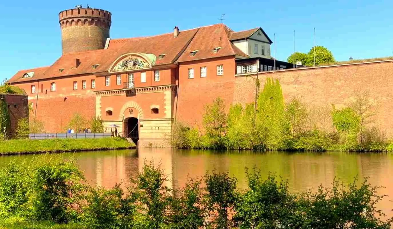
Symmetrical Bastions on Swamp Ground: Italianate Renaissance Fortification Mechanics at Zitadelle Spandau in Berlin
Spandau Citadel (Zitadelle Spandau) rises from a river island at the confluence of the Havel and Spree on the western edge of Berlin — a quadrilateral of earthen ramparts and arrow-shaped bastions that has stood largely intact since its completion in 1594. Commissioned by the Electors of Brandenburg and designed by Italian military specialists, it ranks among Europe’s best-preserved examples of trace italienne fortification and offers one of the most instructive surviving demonstrations of Renaissance defensive engineering adapted to the demands of alluvial, flood-prone terrain.
Key Takeaways
- Spandau Citadel was built between 1559 and 1594 on a Havel river island by Italian military engineers Francesco Chiaramella de Gandino and Rochus Graf zu Lynar under commission from Elector Joachim II of Brandenburg, making it one of the best-preserved Renaissance fortresses in Europe.
- The fortress is a mature trace italienne design: four arrow-shaped bastions — Bastion King (König), Bastion Queen (Königin), Bastion Crown Prince (Kronprinz), and Bastion Brandenburg — connected by curtain walls and surrounded by a water moat formed from the Havel’s own channels, with no blind flanking ground anywhere in the perimeter.
- The Julius Tower (Juliusturm), constructed at the beginning of the 13th century as part of an earlier margravial castle, is Berlin’s oldest surviving secular building; it was deliberately preserved within the Renaissance enclosure as a statement of dynastic continuity rather than demolished to make way for the new works.
- Bastion King (König) retains the only substantially intact three-level casemate system from the original 16th-century construction — a lower gallery for small arms, an upper gallery for combined cannon and infantry use, and a cavalier platform for heavy artillery — making it an exceptionally important document of Renaissance military interior architecture.
- The island’s alluvial substrate and the Havel’s permanent hydrology shaped every major engineering decision: earthen ramparts distributed structural loads across soft soils, while the moat exploited existing river channels rather than requiring excavation through waterlogged ground.
- The water-barrier and earthwork-embankment logic of Spandau’s design finds a structural parallel in Japanese hirajiro (flatland castle) engineering — a convergence reached entirely independently by two traditions working on the same environmental problem without any historical contact.
People Also Ask About Spandau Citadel Architecture
What is the trace italienne and why did it transform European military architecture?
The trace italienne — French for “Italian outline” — is the bastioned fortification system that emerged in Italy during the mid-15th century in direct response to the destructive power of field artillery. Medieval curtain walls, built tall and relatively thin for their passive height advantage against escalading infantry, were catastrophically vulnerable to cannon fire: a sustained bombardment could breach the masonry in hours and topple towers that had resisted ladder assault for decades. Italian engineers responded by lowering and massively thickening the walls, backing their masonry outer faces with compacted earth so that shot was absorbed rather than shattered, and replacing the round medieval tower with the angled bastion. The bastion’s key innovation was geometric: its arrowhead plan projected outward from the curtain wall so that defenders positioned in the flanks could direct fire along the full face of any adjacent wall section, eliminating the blind ground where attackers had previously been able to work unseen and unengaged. No spot on the exterior of a well-designed trace italienne fortress was beyond the reach of defensive fire. This system spread from Italy across Europe during the 16th century, carried by itinerant engineers and the growing body of military treatises. Spandau Citadel, begun in 1559 and completed in 1594, represents the arrival of fully developed trace italienne principles on the North German plain, translated into brick and alluvial earthwork by Italian specialists working for a northern Protestant court.
Who designed Spandau Citadel and what are its defining structural features?
Three successive architects shaped Spandau Citadel’s construction across its 35-year building period. Christoph Römer was the initial construction supervisor before being replaced in 1562 by Francesco Chiaramella de Gandino, the Italian specialist who drew up the master plan and oversaw construction of the two southern bastions — Bastion King (König) and Bastion Queen (Königin). In 1578, Rochus Graf zu Lynar, born Rocco Guerrini in Marradi, Tuscany, in 1525, assumed control and brought the project to completion by 1594, designing Bastion Crown Prince (Kronprinz) and Bastion Brandenburg. The fortress’s defining features include four arrow-shaped bastions at the corners of a roughly quadrilateral perimeter, curtain walls connecting them, a surrounding water moat formed from the Havel’s existing channels, a gatehouse and commandant’s residence on the eastern approach, and the preserved medieval Julius Tower (Juliusturm) and residential palace (Palas) from the earlier castle retained within the new enclosure. Chiaramella’s two bastions differ from Lynar’s in their internal casemate arrangement: Chiaramella built two defensive galleries (one for small arms, one for cannon and small arms combined) plus a cavalier above, while Lynar simplified to a single artillery-level corridor, reflecting a later shift in European fortification doctrine toward heavier-caliber, longer-range guns.
How was Spandau Citadel engineered on its waterlogged island site?
The island in the Havel is composed of alluvial sediments — gravels, sands, and silts deposited over millennia — that are saturated with groundwater, seasonally variable in their water table, and ill-suited to bearing the concentrated structural loads of tall masonry towers without settlement risk. The design addressed these conditions through several interrelated strategies. The primary defensive mass was placed in earthen ramparts rather than solid masonry towers: a broad-based compacted earthen embankment distributes its weight across a far larger ground contact area than a medieval keep, reducing unit loading on soft soils to levels the ground can accommodate. The water moat was formed by managing and widening the Havel’s existing channels rather than excavating a new ditch through saturated ground — a hydraulically efficient choice that ensured the moat was self-filling and self-maintaining by river flow without artificial intervention. The glacis — the gently sloped outer earthwork beyond the moat — graded the transition from water to elevated fortification interior, managing surface water, absorbing cannon shot, and denying direct artillery approaches simultaneously. Renaissance engineers in comparable alluvial river settings throughout Northern Europe routinely employed driven timber pile foundations to transfer masonry loads through soft upper soils to more stable bearing material below; the long, continuously occupied building sequence at Spandau — from Slavic earthwork through medieval stone to Renaissance brick — suggests a similarly layered approach to sub-surface support across successive construction phases, though the specific foundation methods employed at Spandau Citadel are not fully documented in the sources available for this article.
How does Spandau Citadel’s wetland defense strategy compare to fortress traditions in other parts of the world?
Spandau Citadel’s reliance on water barriers, earthen embankments, and the controlled management of river hydrology as its primary defensive envelope finds a structural parallel in the Japanese hirajiro (flatland castle) tradition — though the two traditions arrived at analogous solutions entirely independently, without any historical contact, in response to different threats, and through different architectural cultures. Where European trace italienne design organized its spatial logic around angular bastion geometry, enfilading artillery fire, and the elimination of flanking dead ground, Japanese flatland castle builders of the late 16th and early 17th centuries concentrated on concentric moat systems, steeply battered stone walls rising directly from the water surface, and tiered interior enclosures that forced any attacker to breach successive perimeters without the benefit of cover. Osaka Castle (Ōsaka-jō), constructed from 1583 on the soft alluvial plain of the Osaka River confluence, offers a particularly instructive parallel: like Spandau, it stands on low terrain prone to settlement, uses water as its outermost defensive barrier, and engineered its primary structural mass through a combination of earthwork and masonry above soft ground. The convergence reflects the universal logic of defending flat, wet terrain; it is a case of independent invention, not of exchange or influence, and this article consistently treats it as such.
Extended multi-day tours – 5+ days
Featured Berlin Multi-Day Tour Packages
6 days
6 Days of Discovery: Berlin’s Stories Through Time
- ✓ Comprehensive Berlin tour
- ✓ Expert local guides included
- ✓ All accommodation arranged
- ✓ Transportation provided

5 days
5 Days in Berlin: Discover Potsdam and Sachsenhausen with Expert Guides
- ✓ Comprehensive Berlin tour
- ✓ Expert local guides included
- ✓ All accommodation arranged
- ✓ Transportation provided
5 days
Berlin in 5 Days: From Sachsenhausen to Potsdam & Beyond
- ✓ Comprehensive Berlin tour
- ✓ Expert local guides included
- ✓ All accommodation arranged
- ✓ Transportation provided
7 days
Amsterdam, Berlin and Prague (9 destinations)
- ✓ Comprehensive Berlin tour
- ✓ Expert local guides included
- ✓ All accommodation arranged
- ✓ Transportation provided
Multi-day tour packages powered by TourRadar. Prices and availability subject to change.
Introduction: The Artillery Revolution and the Birth of a New Fortress Type
In the spring of 1494, the army of Charles VIII of France descended the Alps and swept through the Italian peninsula with a mobile artillery train that dismantled the defenses of previously impregnable cities in a matter of days. The medieval tower and curtain wall, which had defined European military architecture for three centuries, met its structural adversary not in a more powerful siege machine of the traditional kind but in a new weapon that could be positioned within range, aimed with increasing precision, and discharged repeatedly against the same section of masonry until it failed. The consequences for military engineers were immediately apparent: the high, thin wall that granted height advantage over escalading infantry was, when facing a cannon battery at point-blank range, simply a large and stationary target.
The problem was existential for fortification as a concept. Stone walls of any medieval thickness could be breached if a sufficient mass of cannon fire was concentrated against a single section long enough. Round towers, whose curved surfaces deflected some shot, were vulnerable at their bases to the rapid accumulation of rubble that provided attackers with a ramp for escalade. The moat — the one element of medieval defense that retained its value — became more important, but it alone was insufficient against an enemy equipped with both cannon to breach the wall and troops to exploit the breach. Italian engineers, confronting this crisis in the decades following 1494, produced the most comprehensive rethinking of military architecture since antiquity.
The solution they developed involved a complete inversion of the medieval vertical emphasis. Walls came down in height; their bases expanded, backed with compacted earth that absorbed incoming shot through deformation rather than shattering under its impact. The round tower gave way to the bastion — a flat-faced, earth-filled, triangular projection calculated to ricochet shot harmlessly away from its angled surfaces and to allow defenders in its flanks to train direct fire along the full length of any adjacent curtain wall section. This was the trace italienne, and by the middle of the 16th century it was spreading northward across Europe carried by the engineers who had developed it and by the military treatises they wrote and circulated. Its geometry was total: a well-designed bastion fort had, in principle, no blind ground anywhere in its perimeter, no wall face that could be approached without exposure to overlapping fire from flanking bastions on either side.
Spandau, on the western approach to the twin towns of Berlin and Cölln, had been a fortified site since at least the 12th century and in all probability earlier. A margravial castle had occupied the Havel river island for generations; by the 15th century it served as a seat of government for the Margraves of Brandenburg. When Elector Joachim II Hector ordered its transformation into a modern artillery-proof fortress in 1559–60, he commissioned specialists in Italian-style military engineering — confirming that Brandenburg understood both the nature of the transformation underway in European defensive doctrine and the technical expertise required to implement it. What those specialists built on the alluvial island over the following 35 years became one of the most coherent, complete, and intact trace italienne fortresses north of the Alps: a structure whose value today lies as much in what it preserves of 16th-century military engineering knowledge as in what it once provided to the electors it was built to protect.
This article examines Spandau Citadel as a technical document — as evidence of how Renaissance military engineers solved specific structural, geometric, and hydrological problems — while also placing its design within the broader history of the trace italienne system and drawing a carefully bounded cross-cultural comparison with Japanese flatland castle engineering that illuminates, through independent convergence, the universal logic that governs defense on flat, wet terrain.
The Trace Italienne System: Origins, Theory, and the Logic of Flanking Fire
The trace italienne did not emerge fully formed from a single act of invention. It developed over the latter half of the 15th century and the first decades of the 16th from the accumulated observations of engineers working to solve a shared, urgent problem. Several key principles, separately identified and then progressively integrated, define the mature system that arrived at Spandau in the 1560s.
The low, thick wall and earthen backing. The first and most immediately obvious response to artillery in Italy was practical: lower the exposed height of the defensive perimeter and greatly increase its mass. A medieval wall’s height was its primary virtue against escalade — ladders and towers needed to reach the parapet to deposit men on the wall-walk — but against cannon it simply offered a larger target above ground. Engineers found that a wall reduced to perhaps a third of its medieval height, with its inner face backed by a deep ramp of compacted earth extending far back into the fortress interior, could resist even sustained bombardment. The earthen backing performed two simultaneous functions: it distributed the impact energy of incoming cannon shot across an enormous volume of material rather than concentrating it at the point of a masonry failure, and it provided a gentle internal ramp from which defenders could maneuver heavy ordnance without external hoisting equipment. When Pisan defenders improvised earthen ramparts behind breached sections of their medieval walls in 1500 to repel a combined Florentine and French assault, their successful resistance demonstrated the principle to the whole of Italy at a moment of maximum military anxiety.
The bastion and the elimination of dead ground. The round medieval tower projected from the curtain wall at intervals and allowed defenders to shoot at oblique angles across the wall face, but it produced arcs of dead ground between adjacent towers — zones where attackers could approach the base of the curtain or even the tower itself without coming within effective fire from the defenders above. The angled bastion eliminated this problem through geometric precision. A bastion consists of two faces pointing outward toward the expected direction of attack, two flanks oriented back toward the curtain wall on either side, and a gorge — the open interior connection back to the main enclosure. Defenders positioned in the casemates or at the parapet of the flanks commanded a direct line of fire along the full face of the adjacent curtain wall. When both flanking bastions at either end of a curtain wall were occupied, no point on that curtain face was beyond the reach of defensive fire. The approach to any section of the wall required passing through the converging fire from the flanks of the bastions at each end — a geometric arrangement that made the attacker’s progress across the open ground far more costly than any medieval wall had managed.
The geometry of optimal spacing. If bastions were placed too far apart, the flanking fire could not cover the full length of the curtain between them, and dead ground reappeared at the midpoint. Too close together, and the flanks could not accommodate cannon in useful numbers. The correct spacing — mathematically derivable from the effective range of the flanking weapons — became the central problem of trace italienne design and generated a substantial body of theoretical literature in 16th-century Italian military engineering. The dimensions chosen at Spandau, with four bastions on a roughly quadrilateral perimeter, represent a practical resolution of this balance for the weapons technology of the 1560s–1590s and for the specific scale of the island site.
The orillon and the protection of the flank gunner. The flanking casemate embrasures, which provided the enfilading fire that made the trace italienne effective, were themselves potentially vulnerable: an enemy battery positioned at an angle could fire directly into the open embrasure and silence the flanking guns before driving a breach in the adjacent curtain. The orillon — a rounded or angled shoulder projecting from the outer end of the bastion’s flank — shielded the casemate positions from this countermeasure. The orillon geometry allowed the flank gunner to work from a protected position while retaining a clear line of fire along the curtain face: the masonry shoulder blocked the direct view from the approach direction while leaving the corridor along the curtain open. The degree of orillon development varied across the bastions at Spandau, reflecting ongoing refinement of this element in contemporary design practice.
The cavalier. Within the body of a bastion, above the main parapet level, the cavalier was a raised secondary artillery platform that extended the field of fire and allowed defenders to engage approaching siege works at greater range. Its elevated position allowed cannon to fire at angles that the main parapet — screened by the bastion face below — could not achieve. At Spandau, the cavalier was a standard feature of the original design, documented most clearly in the surviving three-level arrangement at Bastion King (König).
The ditch, the glacis, and the outer defensive system. Beyond the bastion and curtain wall, the mature trace italienne accumulated a system of outer elements whose functions were mutually reinforcing. The ditch — a broad, deep trench, ideally water-filled — denied direct approach, prevented the placement of siege artillery at effective range against the main wall, and complicated the mining operations with which a determined besieger might otherwise undermine the foundations. The glacis was the extended earthen slope rising gently outward from the counterscarp of the ditch, angled so that cannon shot directed against the main wall struck the earthwork surface first and was absorbed or deflected before it could reach the revetment face. A covered way ran along the outer side of the ditch, sheltered from direct observation and fire by the glacis crest, allowing troop concentrations and sorties outside the main enclosure under protection. At Spandau, the moat formed from the Havel’s controlled channels performed the function of the ditch with the permanent, self-maintaining water depth of a live river rather than a static excavation.
The northward transmission of the system. Italian trace italienne principles reached Northern Europe by the 1520s and 1560s through several parallel channels: the direct hire of Italian engineers by northern courts, the circulation of printed military treatises containing fortification designs, and the experience of northern soldiers and officials who had observed Italian fortification during the Italian Wars. The arrival of Chiaramella de Gandino and subsequently Lynar at Spandau represents exactly this process: a court with the urgency and resources to commission the most capable available expertise importing, for a specific Brandenburg site, the product of a century of Italian engineering development.
The Transition from Medieval Keep to Trace Italienne Artillery Bastions: The Juliusturm Case
No aspect of Spandau Citadel’s design more vividly illustrates the historical moment of its construction than the deliberate preservation and incorporation of the medieval Julius Tower within the new Renaissance enclosure. Where many trace italienne projects razed their medieval predecessors to make way for the new geometry — the logic of artillery fortification demanded the demolition of anything projecting above the low parapet profile — Spandau chose instead to embed its medieval tower at the center of the new works. The fortress is therefore not only a trace italienne design on an island site but also a document of deliberate dynastic continuity, and the reasoning behind that choice tells as much about the politics of early modern Brandenburg as about the structural engineering of the new works.
The Julius Tower and the Margravial Castle: Continuity on a Contested River Island
The Julius Tower (Juliusturm), designated by the citadel’s administration as Berlin’s oldest surviving secular building, was constructed at the beginning of the 13th century as part of the margravial castle that occupied the Havel island in the early medieval period. Its massive circular form — with walls reaching 3.60 meters in thickness at the base — represents the standard defensive architecture of the pre-gunpowder era: a structure that conferred vertical mass, height advantage over any approaching enemy, and a passive resistance to direct assault that the technology of the period could not overcome. The tower served as watchtower, last-resort refuge, and visible assertion of the lord’s authority over the surrounding territory.
The castle’s history before the Julius Tower was already several centuries old. Albert the Bear, first Margrave of Brandenburg, established a frontier fortress on the island in 1157, exploiting the strategic position at the confluence of two major river routes. Archaeological excavations beneath the western curtain wall have revealed a Slavic timber-and-earth fortification wall dated to approximately 1050, predating the Hohenzollern presence on the site by more than a century and demonstrating that the island’s defensive value was recognized long before its incorporation into the Brandenburg political system. These multiple pre-medieval and medieval building phases — documented in situ as stratigraphic layers — place the Renaissance construction within a continuous tradition of occupation and fortification that was already half a millennium old by the time Chiaramella de Gandino began his work.
By the 15th century, the castle had become a seat of government for the Margraves of Brandenburg. The residential palace (Palas) standing beside the Julius Tower was constructed during this period to serve the electors as a representative residence; its current appearance, reflecting late Gothic architecture, is largely a reconstruction from the 1970s and 1980s, since the original structure underwent repeated phases of modification over the intervening centuries. When Joachim II ordered the transformation of the site into a modern fortress in 1559–60, the decision to retain both the Julius Tower and the Palas within the new design was explicit. Both were preserved, in the words of the official citadel documentation, “as symbols of power of the old castle” — a deliberate political statement that the new military works did not displace the dynasty’s heritage but armored it. The Julius Tower, though wholly obsolete as a defensive structure by the standards of the trace italienne, continued to function as a monumental assertion of legitimacy: the tower of the old lords, now enclosed and protected by the most advanced military engineering of the age rather than replaced by it.
The tower climbs to its summit via 153 steps. From the top, the full geometry of the Renaissance enclosure is visible below — the arrow-shaped bastion profiles, the curtain walls connecting them, the encircling moat — and the spatial relationship between the medieval tower at the center and the 16th-century perimeter around it becomes immediately legible as a deliberate architectural statement rather than an accident of survival. Why the tower bears the name Julius has, the official citadel notes, “not been conclusively clarified to this day” — a characteristic admission of genuine historical uncertainty that this article respects and does not speculate beyond.
Hydro-Engineering and Earthwork Glacis: Defensive Sub-Surface Stabilization in Wetland Topography
The island in the Havel imposed engineering constraints that fundamentally shaped every major structural decision at Spandau Citadel and distinguish it from trace italienne fortresses built on consolidated rock or stable soil. The Havel flood plain is composed of alluvial sediments — gravels, sands, and silts deposited by the river system over geological time — that are permanently saturated with groundwater, subject to seasonal variation in the effective water table, and incapable of bearing the concentrated point loads of tall masonry construction without risk of progressive differential settlement. Building a massive defensive enclosure on such ground demanded engineering responses calibrated to its specific physical character, and the solutions adopted by the Italian architects reveal the depth of the technical knowledge they brought to the Brandenburg commission.
The alluvial substrate and the logic of the earthen rampart. The most consequential design decision in terms of geotechnical behavior was the choice to center the primary defensive mass on earthen ramparts rather than unsupported masonry towers. This choice was not primarily motivated by the softness of the Spandau substrate — the trace italienne system was developed in Italy and recommended earthen backing on any soil type, because the earth absorbed cannon shot. But its geotechnical consequences on alluvial ground were significant and advantageous. An earthen rampart distributes its structural weight across an extremely broad base footprint: a rampart ten meters thick at the base and five meters high generates modest unit loading on the ground beneath it, within the bearing capacity of well-compacted alluvial gravel even when saturated. A medieval tower of equivalent height concentrates its entire mass at the perimeter of a comparatively small foundation, producing point loads that may exceed the bearing capacity of loose, water-saturated sediment and cause the tower to tilt, crack, or sink differentially. The trace italienne’s replacement of the tall tower with the broad embankment was, in this sense, intrinsically better suited to the North German alluvial plain than the architecture it superseded — not designed for those conditions but compatible with them in ways that resolved problems the medieval form could not.
The water moat and channel management. The moat surrounding Spandau Citadel was not an excavated ditch subsequently filled with water but rather a system of existing Havel channels deliberately managed, widened, and deepened to form a continuous defensive water barrier around the island perimeter. This approach carried important practical advantages in a saturated alluvial setting. Excavating a deep dry ditch in waterlogged ground is inherently unstable: the walls of any excavation below the water table in loose saturated sediment collapse continuously unless actively shored, and the groundwater pressure immediately floods any pit below the water table regardless of pumping effort. Working with the existing river channels rather than against the hydrology minimized the amount of unsupported excavation required while achieving a broad, deep water obstacle whose inundation was guaranteed by the river’s own gradient and flow without artificial maintenance. The result was a moat whose width and depth varied with the natural channels but whose effectiveness as a defensive barrier was permanently self-sustaining — it could not be drained, blocked, or bridged at short notice, and its soft alluvial bed complicated any attempt to lay a mine or drive a sap beneath the wall foundations from across the water.
Timber pile foundations and load transfer in Renaissance alluvial practice. Renaissance military and civil engineers working in comparable alluvial river environments throughout Northern Europe employed driven timber pile foundations as the standard method for carrying masonry loads through soft upper soils to more stable bearing material beneath. This technique — used extensively in Venice, Amsterdam, and the canal cities of the Low Countries — involved driving closely-spaced wooden piles (typically of oak or elm, species that resist biological decay when permanently submerged below the aerobic zone in waterlogged soils) to refusal, indicating contact with denser gravel or till beneath the soft upper deposits, and then constructing the masonry above a continuous timber grillage or platform that spread the load across all pile tops simultaneously. The conditions at Spandau — permanently saturated alluvial sediment above a presumably denser gravel substrate at depth — are consistent with the conditions in which such foundations perform reliably over long periods. The archaeological evidence of multiple construction phases on the site, spanning from Slavic earthwork through 15th-century stone castle to 16th-century brick fortification, indicates that each generation of builders confronted the same sub-surface conditions and required appropriate technical responses. The specific details of the Spandau foundations are not fully documented in the sources consulted for this article; the application of pile foundation principles remains the inference from period practice rather than a directly confirmed observation, and should be understood as such.
The earthwork glacis as defensive slope and hydraulic management surface. The glacis — the gently sloped outer earthwork rising outward from the counterscarp of the moat toward the surrounding terrain level — performed multiple simultaneous functions in the Spandau defensive scheme. Its primary military purpose was to deny attacking artillery a direct line of sight to the lower portions of the brick revetment: cannon fired at low elevation from beyond the glacis struck the sloped earthwork surface and buried itself or deflected harmlessly rather than striking the face of the curtain wall. The sloped surface also channeled surface water away from the earthen core of the ramparts, directing drainage toward the moat and preventing internal erosion of the embankment material — a function as important to the long-term structural integrity of the earthen ramparts as the military role. On the flat, low-lying island site, where the surrounding terrain offered no natural height advantage over the moat water level, the glacis also helped maintain the moat’s effective depth by grading the transition from the outer ground level down to the water surface rather than presenting an abrupt vertical counterscarp that would itself be vulnerable to direct artillery fire at its base.
The harbour cut and the hydraulic resource strategy. A further dimension of the citadel’s relationship with the Havel is the small protected harbour between Bastion Crown Prince (Kronprinz) and the north curtain wall, already incorporated in Lynar’s fortification plans of 1578. This controlled breakthrough in the curtain wall, sheltered by the flanking masonry above and by the bastion on its western side, allowed boats to pass from the river into a protected basin within the defensive perimeter even under siege conditions. The harbour’s inclusion from the outset of Lynar’s planning indicates that the engineers conceived the river not only as an obstacle to enemy forces but as a logistical resource to be managed and exploited under duress: a siege might cut all land access while river supply remained possible if the hydraulic infrastructure to receive it was designed into the fortification from the start. The harbour portal was subsequently remodeled in the Classicist style in 1818; the basin itself, filled in during the 19th century, was uncovered and restored in 1995.
From Chiaramella de Gandino to Rochus Graf zu Lynar: Two Architects, Two Philosophies
The Spandau Citadel as it stands today is the integrated work of two distinct architects whose design approaches differed in identifiable ways. Understanding these differences is essential for reading the fortress’s plan accurately, because the two pairs of bastions represent not merely separate phases of construction but partially divergent engineering positions within a shared theoretical framework.
Francesco Chiaramella de Gandino took over primary design responsibility from the initial construction supervisor Christoph Römer in 1562. He drew up the master plan establishing the overall quadrilateral perimeter with four bastions at the corners and oversaw construction of the two southern bastions — Bastion King (König) and Bastion Queen (Königin). His approach to the bastion interior maintained two distinct defensive corridors within the casemate structure: a lower gallery intended for infantry and musket fire directed across the moat at close range, and an upper gallery designed for a mixed deployment of cannon emplacements and infantry positions. Above these two galleries, the cavalier platform accommodated the heaviest artillery in the elevated position that maximized its effective range. This three-tier arrangement reflects a design philosophy calibrated for defense at close to medium range, requiring the bastion to cover the moat and ditch face at short distances with both the massed rapid fire of infantry musketry and the shock power of cannon, using each weapon type in the range band where it was most effective.
Rochus Graf zu Lynar took over in 1578. Born Rocco Guerrini in Marradi, in the Tuscan Apennines, on 24 December 1525, he came from a noble Florentine family that held the Linari castle in the Lamone valley — the name from which his German title, Graf zu Lynar, was derived. By the time he arrived in Brandenburg he was already an experienced military architect; from 1578 until his death in Berlin-Spandau in December 1596, just two years after the citadel’s completion, the Spandau commission was his principal project. The two bastions of his design — Bastion Crown Prince (Kronprinz) and Bastion Brandenburg — differ from Chiaramella’s pair in their casemate arrangement. Lynar removed the lower infantry gallery, retaining only a single upper-level artillery corridor plus the cavalier above. The official citadel documentation confirms that “unlike his predecessor, Lynar no longer had a second line of defense for small arms placed here, but only one for artillery.” This simplification did not reduce the bastion’s effectiveness at the longer ranges where artillery dominated; it shifted the emphasis decisively toward heavier-caliber guns rather than the graduated infantry-and-cannon approach of the earlier design, a shift consistent with the general evolution of European fortification doctrine as cannon continued to increase in power and range throughout the later 16th century.
The two architects’ differing approaches can be read directly in Bastion King and Bastion Brandenburg: the King retains its lower corridor (still accessible today on guided tours as the “black corridors”), while the Brandenburg’s single-level artillery arrangement reflects Lynar’s recalibration. Both designs are competent applications of trace italienne theory; their difference captures an ongoing debate within European military engineering about the optimal use of bastion interior volume. Lynar also brought a distinct Italian aesthetic sensibility to the non-military buildings within the citadel: the “Italian courtyards” at the Brandenburg bastion’s cavalier level, with their vaulted rooms and flying buttresses in a vocabulary the official site describes as reminiscent of Venetian architecture, reflect designs he produced in 1580, though the structures visible today date to the 19th century.
The Four Bastions: Geometry, Artillery Integration, and Flanking Coverage
The heart of Spandau Citadel’s defensive system lies in its four bastions, and each preserves a different chapter of the fortress’s construction and operational history. Together they define the quadrilateral perimeter and embody — in their agreements and variations — the design evolution from Chiaramella’s commission through Lynar’s completion of the project.
Bastion King (König). The King bastion is the most architecturally significant survivor at the citadel and one of the most important intact examples of 16th-century casemate design anywhere in Europe. Its plan is the original Chiaramella arrowhead: two faces pointing outward toward the southwestern approach, two flanks oriented to command the adjacent curtain walls, and the broad gorge connecting it to the main enclosure interior. Within the body of the bastion, three distinct defensive levels remain largely as built: the lower corridor, positioned to cover the moat and ditch face at close range with infantry fire through embrasures cut through the outer brick face; the upper casemate corridor, designed for a combined deployment of artillery pieces and infantry positions and commanding the moat surface and approach glacis at medium range; and the cavalier at the summit, for heavy cannon at long range above the general parapet line. The official citadel documentation confirms that Bastion King “is the only one that still shows, partially unchanged, the 16th-century defensive design with three corridors called casemates.” The casemates were filled with sand and earth in the 17th century as weapons technology evolved and the galleries became tactically redundant, then excavated and made accessible again in the 19th century. The lower gallery served as an air-raid shelter during the Second World War. Today these corridors — known as the “black corridors” for their atmospheric interior lighting — are accessible on summer guided tours and are among the most visited spaces in the citadel.
Bastion Queen (Königin). The Queen bastion was designed by Chiaramella de Gandino and in its original configuration mirrored the King’s three-level casemate system. It suffered the most catastrophic structural event in the citadel’s history: during the Prussian siege of 1813, artillery bombardment directed against the French-held fortress ignited fires that spread to the powder magazine within the bastion, causing an explosion sufficient to destroy it entirely. The subsequent 19th-century reconstruction was minimal rather than restorative — a single defensive gallery, a three-part arch arcade providing access, and a cast-iron railing — and does not reproduce the original Chiaramella casemate arrangement. The Queen bastion as it stands today is therefore a 19th-century structure on a 16th-century footprint; its current form cannot be read as an authentic record of the original design. Further significant modifications were made from 1935 onward in connection with the Wehrmacht’s gas protection research program on the citadel. The casemate spaces that survive beneath this bastion are accessible in summer on guided tours.
Bastion Crown Prince (Kronprinz). Bastion Crown Prince was designed by Lynar and reflects his single-tier artillery philosophy: one casemate corridor for cannon fire rather than Chiaramella’s two-tier arrangement, with a ramp for moving heavy guns to the plateau level. Its major structural catastrophe predates that of the Queen bastion by more than a century: in 1691, lightning struck the powder tower on the plateau, detonating the stored ammunition and destroying substantial portions of the bastion structure. The reconstruction that followed introduced Baroque architectural elements into those sections rebuilt in the late 17th century, while further Classicist modifications followed in the 19th century. The exterior masonry facing visible on all four bastions today dates from a systematic refacing campaign carried out between 1881 and 1885. From 1935, the Wehrmacht used the bastion as a central materials store for toxic chemicals associated with its gas protection laboratory; decontamination work carried out in the 1990s revealed buried containers of warfare agents in the area. The plateau today houses the Youth Art School (Jugendkunstschule).
Bastion Brandenburg. The Brandenburg bastion was also designed by Lynar and shares the Crown Prince’s single artillery-level casemate arrangement. Its cavalier is covered by the “Italian courtyards” — vaulted rooms with an architectural vocabulary evoking Venetian Renaissance design, including flying buttresses — whose layout derives from Lynar’s 1580 plans though the current structures date to the 19th century. The cannon tower on the bastion was severely damaged by the Prussian bombardment of 1813. The plateau buildings visible today date from the 1930s and represent the structures erected in connection with the Wehrmacht’s chemical weapons experimental program. The bastion’s interior spaces are now primarily used as an event venue.
The geometric relationship of all four bastions. The four bastions are positioned so that the flanks of each cover the full face of the adjacent curtain wall. The spacing of the bastions along the perimeter was determined by the requirement that a defender in any bastion flank could bring effective fire along the entire adjacent curtain without leaving a midpoint dead zone — a geometric constraint determined by the effective range of the flanking weapons. The roughly quadrilateral plan with sides of approximately 200 meters represents a practical resolution of this constraint for the weapons technology available when Chiaramella drew the master plan in the 1560s: close enough for flanking coverage, large enough to accommodate the required garrison and logistical infrastructure. An attacker attempting to approach any curtain wall section between two bastions would be simultaneously exposed to converging flanking fire from the flanks of both neighboring bastions — the quintessential tactical virtue of the trace italienne that made the system so formidable against 16th-century siege methods.
Casemate Architecture: Vaulted Chambers, Subterranean Defense, and the Underground Garrison
The casemate is the architectural element that most vividly distinguishes the interior organization of the trace italienne fortress from that of the medieval castle. Where the medieval keep concentrated its functional spaces in a single dominant tower or enclosed hall, the bastion fort distributed its defensive capabilities through a network of vaulted underground and semi-subterranean chambers embedded within the mass of the bastions and curtain walls. At Spandau, the casemates of Bastion King represent the single most important surviving 16th-century document of Renaissance military interior spatial organization in Germany.
The structural logic of the casemate vault. A casemate is, at its most fundamental, a vaulted chamber from whose outer wall gun embrasures have been cut to allow cannon or small arms to fire without exposing the crew above the parapet. The structural challenge was considerable: the vault had to carry the weight of the compacted earth and masonry above it — including the gun platforms on the rampart surface and any cannon deployed there — while remaining resistant to the dynamic shock loading transmitted both by firing artillery from within the chamber and by incoming projectiles striking the outer revetment above and adjacent to it. The solution employed across Renaissance military construction was the barrel vault in fired brick, with walls and vault thickness calibrated to absorb and distribute these dynamic loads through arch action and mass rather than resisting them at a point. The result was a structure that could sustain remarkably severe external shocks — the repeated recoil of heavy cannon fired from within, and cannon ball impacts on the outer face — without catastrophic failure, provided that the overall embankment mass around it was maintained and the drainage of the earthen fill was managed to prevent excessive pore water pressure in wet conditions.
Embrasure design and fields of fire. The embrasures cut through the casemate walls are splayed in section — wider on the interior than on the exterior opening. This splay served two purposes simultaneously: it gave the gun or musket a working arc of elevation and traverse without requiring the gunner to reposition the entire weapon for each adjustment, and it minimized the size of the opening on the exterior face, reducing both the visual target offered to counter-battery fire and the structural weakness created by the penetration through the masonry. The angle of the splay was calculated in relation to the specific fields of fire required: a casemate in a bastion flank, for example, needed its embrasure to sweep along the adjacent curtain wall face, which dictated a splay angle oriented along the curtain rather than perpendicular to the bastion face.
The three tiers at Bastion King in detail. The three-tier casemate arrangement at Bastion King exemplifies Chiaramella de Gandino’s approach to interior defensive organization at a level of detail preserved nowhere else at the citadel. The lowest corridor occupies the base of the bastion at or near the level of the moat water surface. Access was through passages cut through the brick face of the bastion and through internal communication routes within the rampart body. Its embrasures command the moat surface at close range, covering the distance at which an attacker who had crossed the water obstacle would be attempting to mine the base of the wall or establish a foothold at the counterscarp. The second tier — the upper casemate gallery — is positioned with wider embrasures accommodating cannon alongside infantry positions. Its coverage arc spans the moat surface and approach glacis at medium range, where the combination of artillery shock and infantry fire density is most effective against approaching siege works. The cavalier above the two gallery levels carries the heaviest guns at elevation above the general bastion profile, commanding the open terrain beyond the glacis at the longest ranges available. Each tier covers a different range band: close-range moat; medium-range approach; long-range approach and open terrain. Together they constitute an integrated fire plan distributed through vertical depth rather than concentrated at a single elevation.
The casemates as ecology. The consistently cool, humid, and permanently sheltered environment of the Spandau casemates has, since their regular military use ended, made them one of Europe’s important natural refuges. The citadel’s casemate complex is documented by visitBerlin as “one of Europe’s largest winter habitats for bats” — a colony that occupies the vaulted galleries during the cold months when the bats require stable temperatures and undisturbed hibernation. This ecological significance directly shapes the visitor access regime: the casemate guided tours operate in the summer months only, when the colony has departed for warmer quarters, protecting the hibernating animals through the winter. The cohabitation of 16th-century military engineering and a protected bat colony is one of the more arresting contemporary manifestations of the fortress’s centuries of continuous adaptive reuse.
The catastrophic powder magazine failures. The most structurally consequential episodes in the casemate history of Spandau Citadel were both caused by the ignition of stored gunpowder within the bastion vaults — the inherent structural hazard of the trace italienne system, which required the storage of large quantities of ammunition within or immediately adjacent to the casemate spaces. In 1691, lightning struck the powder tower on the Bastion Crown Prince (Kronprinz) plateau, detonating the ammunition and destroying substantial portions of that bastion. In 1813, fire spreading through the French-held Bastion Queen (Königin) during the Prussian siege reached the powder magazine with sufficient force to destroy the bastion so thoroughly that reconstruction rather than repair was the only option. Both events illustrate an inescapable tension in the design logic of the casemate system: the thick masonry and earthen surround that made the galleries so resistant to external attack became a catastrophic confinement when the explosive stored within them was set off internally.
Curtain Walls and Flanking Fire: The Geometric Logic of the Spandau Plan
Between the four bastions of Spandau Citadel run the curtain walls — the connecting sections of rampart that form the straight sides of the defensive perimeter. In medieval design, the curtain was the primary defensive barrier, the main wall whose height and thickness were the fundamental measure of the fortress’s strength. In the trace italienne, the curtain becomes a defended surface rather than a defensive organ: its face is the zone that needs protection, and the bastions flanking it are the elements that provide that protection. The entire geometric system of the Spandau plan can be read as an arrangement of bastions in optimal mutual-support positions with the curtain walls as the defended intervals between them.
Why attackers targeted the curtain. Any besieging force attempting a breach at a trace italienne fortress would ideally direct its main battery against a curtain wall rather than a bastion face. The curtain is the straightest, least complicated section to attack with artillery: its face presents a perpendicular target to a battery positioned directly opposite it, and a successful breach opens a gap in the enclosure without requiring the attacker to first neutralize a flanking bastion. The trace italienne’s entire geometric rationale exists to make this approach as costly as possible. A battery placed opposite the curtain face in an attempt to breach it is also within the flanking fields of fire of the bastions at each end of that curtain — it is simultaneously engaging the wall it is trying to breach and absorbing fire from both flanking bastions simultaneously. Driving approach trenches toward the curtain exposes the sappers to this same converging fire throughout their advance.
The north curtain and harbour access. The northern curtain between Bastion Crown Prince (Kronprinz) and Bastion Brandenburg incorporates the harbour portal — the controlled water passage included in Lynar’s 1578 plans that allowed river boats to access the protected harbour basin within the moat. This aperture in the curtain wall was necessarily a structural compromise and a potential security point requiring careful design of the flanking masonry to maintain both structural integrity in the vault above the water opening and defensibility of the approach through it. The existing harbour portal, in its Classicist form dating to 1818, still shows the scale of the aperture cut through the rampart mass. The original 1578 design and its subsequent 17th-century modification are documented in the citadel’s administrative records; the 1995 uncovering and restoration of the basin returned this feature to visibility after more than a century of concealment.
The gatehouse and eastern approach. The gatehouse on the eastern face occupies the most structurally and tactically complex position in any trace italienne fort: the necessary point of entry and exit through which all friendly traffic must pass and which any attacker seeks to force, isolate, or neutralize. At Spandau, the gatehouse has been repeatedly modified since its initial construction, reflecting its continuous use over four and a half centuries. Elements of the Renaissance-period three-arched hall remain visible in the interior, despite the bricking up of the arches in 1838–39 and their reopening in 1967; the facade to the entrance bridge was not substantially altered after the 1839 modifications and retains the form imposed by that phase. The entrance bridge over the moat — a controlled crossing that could be drawn up, broken, or blocked in an emergency — is the final physical threshold between the fortress’s island position in the Havel and the surrounding town of Spandau. The coat of arms of Brandenburg-Prussia above the gateway continues to assert the dynastic authority that the fortification was built to defend.
Rochus Graf zu Lynar: Italian Engineer in Brandenburg Service
Of the three architects who directed construction at Spandau Citadel, Rochus Graf zu Lynar left the most complete and lasting impression on the finished fortress. He took over the project in 1578, brought it to completion in 1594, and died in Berlin-Spandau in 1596 — two years after the fortress was finished and still in the city where his principal work stood. His career exemplifies a characteristic pattern of 16th-century military engineering: Italian technical expertise, developed at the center of the most advanced fortification culture in Europe, transplanted to a northern court whose resources and political urgency created demand for exactly that knowledge.
Born in Marradi, a small Apennine town in the upper Lamone valley east of Florence, on 24 December 1525, Rocco Guerrini came from a noble Florentine family whose principal property was the Linari castle — the origin of the title “Count of Linari” (Graf zu Lynar in German usage) that he assumed from 1571. The specific details of his military engineering training and his earlier fortification commissions before arriving in Brandenburg are not fully documented in the sources consulted for this article; the claim that he was “trained” in any specific location or school should not be made without evidence beyond what is confirmed. What is well established is that by the time he took responsibility for the Spandau project in 1578, he commanded a level of technical mastery sufficient not merely to continue an existing design but to modify it in identifiable and architecturally coherent ways, adjusting Chiaramella de Gandino’s casemate philosophy for the two new bastions while maintaining the overall spatial integrity of the quadrilateral plan.
His two bastions — Crown Prince (Kronprinz) and Brandenburg — embody a consistent departure from Chiaramella’s two-tier casemate philosophy toward a single artillery-level approach. The official citadel documentation is explicit that Lynar’s bastions had “only one for artillery” rather than the two defensive corridors of his predecessor. This was not a simplification imposed by budget constraint or urgency; it reflects a design judgment about the relative value of infantry versus artillery defense in the bastion flanks, made at a moment when the trend in European fortification theory favored concentrating resources in the higher-caliber, longer-range artillery tier. The precision of the spatial organization in Lynar’s bastions and the consistency of his departure from Chiaramella’s arrangement across both of his bastions indicate a deliberate theoretical position rather than an expedient adaptation.
The “Italian courtyards” — the vaulted rooms at the cavalier level of Bastion Brandenburg, whose architectural vocabulary evokes Venetian Renaissance design through their flying buttresses and arcade elements — derive from Lynar’s 1580 designs. The current structures are 19th-century rebuildings of the original forms, but the spatial concept and the aesthetic sensibility they represent are his. Their explicitly Italian architectural character, maintained in a German brick construction on a Brandenburg river island, is a deliberate cultural statement: Lynar brought not only Italian technical knowledge to his Brandenburg commission but Italian spatial thinking, and the citadel reflects this in the architectural language of its non-military interior buildings as well as in the geometry of its defensive works.
His inclusion of the harbour feature in his 1578 plans reflects an integrated strategic thinking that went beyond the fortification perimeter to consider the island’s position in the wider river system. The harbour was not added as a convenience but designed from the outset as part of the island’s defensive logic: the river that surrounded the fortress and formed its moat could also supply it, provided the hydraulic infrastructure to receive river-borne supply was incorporated in the design from the start. This integration of hydrological resource management with military planning is among the most distinctive aspects of the Spandau design and one of Lynar’s characteristic contributions to it.
Lynar founded a German family line — the Lynar line — that remained significant in Brandenburg-Prussian history beyond his death. A street in Spandau bears his name, following the route of powder magazines he established. The fortress he completed remains the primary monument to his work and to the tradition of Italian military engineering that he represented in its northern European deployment.
Convergent Wetland Defense: European Star Fort Geometry and Japanese Flatland Castle Strategy
The engineering challenge of defending on flat, wet, river-threaded terrain is not culturally specific — it is an environmental problem whose physical parameters are the same regardless of the civilization confronting it. When European military architects of the 16th century and Japanese castle builders of the same general period were both compelled to address this problem in their respective contexts, they arrived at strategies that display a structural convergence striking enough to demand analysis. This convergence was reached entirely independently, through separate engineering traditions, in response to different threats, using different materials and aesthetic frameworks, and without any historical contact, transmission, or exchange between the two cultures. It is, in the precise technical sense, a case of convergent development: two traditions arriving at analogous solutions to the same environmental constraints through independent reasoning. No genealogical relationship between the European and Japanese forms is implied or suggested by the comparison; the parallel illuminates only what the physical environment required, not any connection between the traditions that responded to it.
The hirajiro tradition in Japanese castle design. The classification of Japanese castles developed systematically during the Edo period (1603–1868) and distinguishes three primary typological categories based on the terrain on which the castle was built. Mountain castles (yamajiro) occupied hilltops and ridge spurs, exploiting natural elevation for defense. Hilltop-plain hybrid castles (hirayamajiro) stood on low natural prominences. Flatland castles, known in Japanese as hirajiro, were constructed on plains or river islands where no natural elevation was available. The hirajiro tradition confronted exactly the defensive problem that the trace italienne also addressed at Spandau: how to create an effective defensive perimeter when the terrain offers no natural height advantage. The solution, in both cases, was water. Japanese flatland castle builders exploited rivers, marshes, and excavated channels to create multiple rings of moats that substituted for the height differential of a hilltop, slowing enemy approach, impeding the movement of siege equipment, and forcing attackers to cross open water under defensive fire before reaching the main walls. The wide, deep water moat was the functional equivalent in hirajiro design of the mountain ridge in yamajiro design, and in both the European and Japanese traditions it was recognized as the primary defensive medium on flat terrain.
Osaka Castle and the engineering of alluvial ground. Osaka Castle (Ōsaka-jō), constructed from 1583 under the direction of Toyotomi Hideyoshi during the final phase of Japan’s Warring States unification, is one of the most instructive Japanese parallels to Spandau Citadel’s engineering because it shares not only the flat terrain and water-moat strategy but the specific challenge of building on soft alluvial ground. The castle stands on the low plain of the Osaka River confluence — terrain geologically comparable to the Havel flood plain at Spandau — and its construction addressed the problem of founding a massive defensive structure on soft, saturated sediment through strategies analogous in their engineering logic to those employed in Germany three decades earlier. The main keep and its surrounding enclosures were raised on two tiers of artificial platforms created through extensive landfilling, elevating the core above the surrounding terrain while distributing the structural mass across the filled area rather than concentrating it on narrow point foundations. The sheer stone walls rising from the moat water surface used a technique for interlocking cut stone, described by English-language sources including Wikipedia as “burdock piling,” designed to resist the lateral hydraulic pressure and seismic activity inherent to the region’s soft sedimentary soils. The castle’s moat system divided the enclosure into concentric defensive zones — an inner moat separating the primary keep enclosure from secondary spaces, and an outer moat marking the perimeter — creating a layered spatial organization structurally analogous to Spandau’s outer water barrier and inner defensive perimeter, though reached through entirely different geometric and aesthetic logic.
The universal logic of water as primary defense on flat terrain. Both traditions recognized that the single most effective defense available to a garrison on flat, low-lying ground was the creation of a wide water barrier that forced any attacker to approach over open water — the most exposure-inducing, equipment-hampering, and time-consuming medium available to any pre-modern military force. A soldier crossing a moat under fire was simultaneously vulnerable, slow, wet, encumbered, and unable to use his weapons effectively. A siege battery attempting to reach effective range against a wall surrounded by water required a floating or bridging infrastructure that was difficult to construct, easy to disrupt, and impossible to protect from sorties. This recognition was independent in each case: European engineers arrived at it through the application and adaptation of Italian trace italienne theory to northern river environments; Japanese castle builders arrived at it through the practical experience of the Warring States period, in which the flat, water-threaded plains of western Honshu made water moats the natural and well-tested defensive medium for flatland strongholds. The equivalence of result — the moated island or river-encircled stronghold as the canonical solution to flatland defense — reflects the universality of the engineering problem, not any connection between the traditions.
Key structural divergences that illuminate the comparison. The convergence in basic strategy masks equally significant divergences in execution, emphasis, and aesthetic framework that reflect the distinct architectural and social contexts of each tradition. European trace italienne design organized its spatial logic around angular bastion geometry, mathematical optimization of enfilading artillery fire, and the systematic elimination of flanking dead ground. The visual and spatial character of the star fort is an aesthetic of geometric precision deployed in service of cannon warfare: everything in the plan derives from the requirement to achieve maximum fire coverage with minimum construction. The profile is deliberately, insistently horizontal — the entire military-theoretical rationale of the system required that the defensive perimeter be kept as low as possible, both to deny a target to incoming cannon and to present the angled ricochet surfaces rather than the vertical faces that medieval walls offered. Japanese flatland castle design placed its emphasis, by contrast, on vertical masonry above the water surface. The ishigaki — the steeply battered stone wall rising directly from the moat — and the tenshu tower keep commanding the interior from above were visually and symbolically the defining elements of the Japanese castle, projecting height as a signal of the lord’s power and as a last-resort stronghold even at the cost of a degree of ballistic exposure that European trace italienne engineers had specifically learned to avoid.
Material choices also differed substantially. European trace italienne fortification at Spandau used fired brick for the revetment faces and compacted earth for the rampart fill — the materials most abundant and economically appropriate in the North German brick-building culture of the period. Japanese flatland castle construction used cut stone (typically granite or andesite) for the ishigaki walls and timber for the superstructure, reflecting Japan’s abundant stone resources and long tradition of cut-stone walling. Both choices were materially rational given the respective regions’ geological and economic resources; neither was transferable to the other context without the prerequisites that made it viable.
What the comparison demonstrates. The structural parallel between Spandau Citadel’s moated earthwork enclosure and the Japanese hirajiro castle tradition is instructive precisely because it confirms that certain engineering solutions are environmentally constrained rather than culturally optional. When flat, wet terrain imposes the same set of physical parameters on two independent engineering traditions, those traditions independently converge on analogous solutions: water as the primary defensive barrier, elevated interior ground above soft substrate, broad distribution of structural mass rather than concentration at height, and layered perimeter zones that force any attacker to breach successive barriers rather than penetrating to the core in a single assault. Spandau Citadel and the hirajiro castles of late feudal Japan are, in this reading, independent experiments conducted by separate civilizations on the same engineering problem using the materials and technical knowledge available to each. The identical structural conclusion — the moated island stronghold — testifies to the constraining power of the physical environment over the range of viable architectural responses, not to any shared heritage or transmission between the traditions that generated it.
Centuries of Use, Damage, and Conservation at Spandau Citadel
The history of Spandau Citadel after its completion in 1594 is one of continuous occupation, repeated partial destruction by accident and siege, piecemeal reconstruction in changing architectural styles, and the progressive accumulation of successive uses over a structural core that has survived — despite considerable damage — substantially as the Italian architects designed it.
The fortress saw its first recorded siege in 1675, when Swedish forces besieged the citadel. It remained untaken. In 1806, during the collapse of Prussian resistance to Napoleon, the garrison surrendered to the French army without firing a shot — a capitulation that reflected the wider military and political circumstances of the Prussian defeat rather than any failure of the fortification itself. The citadel remained under French occupation until the Wars of Liberation; the Prussian siege of 1813 proved far more destructive to the fabric of the fortress than any earlier military event. The powder magazine explosion in Bastion Queen (Königin), triggered by the Prussian bombardment that set fires throughout the French-held works, destroyed that bastion so completely that its reconstruction in the early 19th century produced only a simplified echo of the original Chiaramella design. The cannon tower on Bastion Brandenburg was also severely damaged by the same bombardment. The siege of 1813 represents the most significant single episode of structural damage in the citadel’s history resulting from military action.
Between 1874 and 1919, the citadel acquired an unexpected peacetime significance. The Imperial War Treasure (Reichskriegsschatz) — the war indemnity paid by France following the Prussian victory in the Franco-Prussian War of 1870–71 — was stored in the Julius Tower, whose 3.60-meter walls made it a natural vault. The storage of this deposit gave rise to a political idiom that persists in German usage: federal budget surpluses are still colloquially referred to as a “Juliusturm,” the name of the tower where the national reserve was once kept.
The most disturbing chapter in the citadel’s later history began in 1935, when the Wehrmacht assumed control of significant sections of the fortress for chemical weapons research and development. The armory building, constructed in the 19th century, was used from 1936 as a nerve gas laboratory. Bastion Crown Prince (Kronprinz) served as a central materials store for highly toxic chemicals used in the gas research program. Animal experiments connected to the gas protection laboratory took place on and around Bastion Brandenburg. The provisions depot was converted for test chambers. The 19th-century buildings on the Kronprinz and Brandenburg plateaus, which replaced earlier structures, date from this era of military research. Decontamination work carried out in the 1990s uncovered numerous buried containers of warfare agents in the Crown Prince bastion area — the lasting physical legacy of the fortress’s wartime misuse.
Postwar recovery proceeded gradually. A construction school occupied the buildings from the late 1940s through the 1960s and 1970s. Archaeological investigation during construction work from 1955 revealed Jewish gravestones incorporated into the Palas foundation, documenting the citadel’s entanglement with the wider history of Spandau’s medieval community. The Gothic Hall of the Palas was reconstructed in 1982. The harbour basin, filled since the 19th century, was uncovered and restored in 1995. The Italian courtyards were completed as an event space in 2003. The exterior coat of arms above the gatehouse was restored in spring 2021. These successive interventions have cumulatively stabilized and partially restored a complex that, despite the damage of the Napoleonic era and the wartime research period, retains the fundamental spatial organization and the primary structural fabric of the 16th-century construction.
Today the citadel is managed by the Kulturamt Spandau and serves as a multi-institution cultural complex. The Spandau City History Museum occupies the 19th-century armory building. The exhibition “Unveiled” (Enthüllt) in the provisions depot examines Berlin’s public monuments and their histories. The permanent exhibition “Castle and Citadel” in the gatehouse traces the architectural development of the site. The Center for Contemporary Art (ZAK) occupies the former Old Barracks. The inner courtyard has operated as an open-air concert venue since 2005, hosting the annual Citadel Music Festival. The combination of preserved Renaissance military architecture, medieval tower, and active contemporary cultural programming makes Spandau Citadel one of Berlin’s most layered heritage environments.
Visiting Spandau Citadel: Practical Information for Architectural Visitors
Spandau Citadel stands at Am Juliusturm 64, 13599 Berlin, in the Spandau borough of the far western city. The fortress is open Friday through Wednesday from 10:00 to 17:00, and Thursday from 13:00 to 20:00, with last entry 30 minutes before closing. Visitors should verify hours via the official website before arriving on event days, as concert and festival programming — particularly in summer months — can shift the museum schedule. Admission on the first Sunday of most months is free. The standard adult ticket is €4.50; concessions (pupils, students, trainees, and benefit recipients) pay €2.50; the family ticket is €10; children under six enter free. One ticket covers all permanent exhibitions, museums, and the Julius Tower ascent.
Public guided tours of the full fortress run every Saturday and Sunday at 14:00, at €4.50 per person in addition to the citadel admission ticket. These tours are the recommended starting point for a visitor approaching the fortress primarily as an architectural object: the guide covers the construction history, the function of the bastions, the Napoleonic-era events, and the storage of the Imperial War Treasure, providing the contextual framework within which the spatial evidence of the surviving walls becomes legible.
The Julius Tower is accessible independently during all citadel opening hours, 365 days a year except during conditions of black ice and storms. Climbing its 153 steps to the summit provides the single most important aerial perspective available on the citadel’s plan: from the top of the medieval tower, the arrowhead profiles of the four bastions, the connecting curtain walls, the encircling moat, and the course of the Havel’s channels are all visible simultaneously. No ground-level position within the enclosure allows this reading of the overall spatial organization; the Julius Tower ascent is, for the architecturally interested visitor, the essential first move before exploring the individual elements at ground level.
The casemate tours — the primary architectural destination within the citadel, giving access to the vaulted lower and upper galleries of Bastion King (König) — operate in the summer months only, limited by the requirement to protect the bat colony that hibernates in the casemate galleries through winter. These tours should be booked in advance through the official website, as places are limited and summer dates fill quickly. The “black corridors,” accessible only on this tour, are the most immediate architectural encounter with the original 16th-century casemate construction available anywhere at the citadel: the barrel-vaulted brick ceilings, the embrasure openings still oriented along the original flanking fire angles, and the massiveness of the masonry surrounding each gallery are all visible at close range. The casemates of Bastion Queen (Königin) are also accessible during the summer touring season.
Transport access is direct. The Berlin U-Bahn line U7 serves Zitadelle station — named directly for the fortress — and the citadel’s entrance bridge is a five-minute walk from the platform exit. Alternatively, S-Bahn lines S3 and S9 serve Berlin-Spandau station from central Berlin in approximately 30 minutes from Hauptbahnhof or Alexanderplatz, and the U7 connects onward from Spandau. All travel falls within the Berlin AB fare zone. Arriving visitors may also find it worthwhile to include the Spandau old town in their visit: the well-preserved medieval street grid, accessible by bridge from the citadel entrance and served by its own U7 station at Altstadt Spandau, provides the settlement context within which the fortress was always embedded and which the fortress was built to protect.
Frequently Asked Questions
What makes Spandau Citadel one of Europe’s best-preserved Renaissance fortresses?
Spandau Citadel’s exceptional state of preservation reflects a combination of historical chance and structural robustness. The fortress was never successfully reduced by a conventional 16th- or 17th-century siege employing the methods it was designed to resist; the only major structural damage it sustained came from internal powder magazine explosions in 1691 and 1813 rather than the progressive artillery demolition of walls that reduced many comparably designed fortresses to rubble. Its island position, maintained by the Havel’s persistent river flow, ensured the moat remained effective without continuous maintenance investment. After the military era ended in 1945, the structural integrity of the citadel was sufficient to support conversion to cultural use — a threshold that many more severely damaged fortresses could not reach. The result is a complex where all four bastions, the curtain walls, the gatehouse, the water moat, the medieval Julius Tower, and the 15th-century Palas remain in situ and spatially comprehensible in their relationships, making the citadel an exceptionally complete document of late-16th-century military architecture at a scale and level of completeness that few comparable European examples can match.
What is the Julius Tower and why is it historically significant?
The Julius Tower (Juliusturm) is a circular medieval defensive tower constructed at the beginning of the 13th century as part of the earlier margravial castle that occupied the Havel island long before the Renaissance citadel replaced it. Its walls reach 3.60 meters in thickness; the tower is climbed via 153 steps and the official citadel administration designates it Berlin’s oldest surviving secular building. When Elector Joachim II ordered the construction of the Renaissance fortress in 1559–60, the Julius Tower was preserved intact and incorporated into the new enclosure as a deliberate symbol of dynastic continuity — the tower of the old lords armored and protected rather than demolished by the new military works. Why the tower bears the name Julius has not been conclusively established. Its most significant later use was as the repository of the Imperial War Treasure (Reichskriegsschatz) between 1874 and 1919 — the indemnity paid by France following the Franco-Prussian War of 1870–71 — an episode so embedded in German political culture that federal budget surpluses are still colloquially referred to as a “Juliusturm.”
What are the core trace italienne design principles embodied at Spandau Citadel?
Spandau Citadel embodies four interrelated trace italienne principles in combination. First, low profile: the earthen ramparts and brick revetment are kept to a height far below medieval walls, reducing the target offered to artillery while providing a working parapet for defenders. Second, earthen backing: the brick outer face is backed with compacted earth that absorbs incoming cannon shot rather than shattering under it, making sustained artillery reduction of the wall far more difficult and time-consuming than against plain masonry. Third, angular bastion geometry: the four arrow-shaped bastions project at the corners of the perimeter so that defenders in the bastion flanks can direct fire along the full face of every adjacent curtain wall, eliminating any dead ground where attackers could approach unseen. Fourth, the water moat: the Havel channels encircling the island create a broad water barrier that prevents artillery from being placed at effective close range against the wall base and complicates every phase of a conventional 16th-century siege operation. Together, these four elements made Spandau Citadel largely immune to the artillery-based reduction methods of its era — which is why its most significant structural damage came from internal accidents rather than external military success.
How did Chiaramella de Gandino and Rochus Graf zu Lynar differ in their approach to the bastions?
The two principal architects differed most clearly in their design of the bastion’s interior casemate organization. Francesco Chiaramella de Gandino, who designed Bastion King (König) and Bastion Queen (Königin) in the 1560s and 1570s, built two distinct defensive corridors within each bastion: a lower level for infantry and small arms fire at close range across the moat, and an upper level for a mixed deployment of cannon and infantry at medium range, plus the cavalier platform above for heavy artillery. This two-tier arrangement was calibrated for integrated short-range and medium-range defense using both weapon types in their optimal range bands. Rochus Graf zu Lynar, who designed Bastion Crown Prince (Kronprinz) and Bastion Brandenburg from 1578 onward, simplified the arrangement to a single artillery corridor, removing the infantry level. The citadel’s official documentation confirms that Lynar placed “only one for artillery” rather than the two defensive levels of his predecessor. This reflects a later-16th-century shift in European fortification doctrine toward concentration of resources in heavier-caliber, longer-range artillery rather than the graduated infantry-and-cannon approach. Both designs are effective applications of trace italienne theory; their difference documents a genuine design evolution within a single building project.
What are casemates, and how do they function in Renaissance bastion fortification?
A casemate is a vaulted chamber within the mass of a bastion or curtain wall from which artillery pieces or infantry could fire through embrasures — angled apertures cut through the outer face — without exposing the crew on the open parapet above. In Renaissance design, the casemate served several interconnected functions. It provided a sheltered position for cannon protected from direct counter-battery fire; it allowed fire at low angles along the moat surface and across the ditch face at ranges and elevations that parapet-mounted cannon could not efficiently achieve; and it gave defending troops protected communication routes through the body of the fortification. The barrel-vaulted brick construction — the standard casemate structural form — carried the weight of the earthen rampart above through arch action while absorbing the dynamic shock of friendly artillery firing from within and incoming projectiles striking the outer revetment. At Bastion King (König), the three-tier arrangement — close-range infantry gallery, medium-range cannon gallery, and high-angle cavalier — shows all three levels in their original spatial relationship, making it the most complete surviving document of 16th-century bastion interior organization at the citadel and one of the most important of its kind in Europe.
How did the island site shape the engineering choices made at Spandau Citadel?
The Havel island imposed two categories of engineering challenge that shaped every major design decision: geotechnical and hydraulic. Geotechnically, the alluvial substrate — river sediments permanently saturated with groundwater — cannot bear the concentrated point loads of tall masonry towers without risk of settlement. The trace italienne’s reliance on broad earthen ramparts rather than vertical masonry walls was, as a consequence, geotechnically well suited to the island site: a wide earthen embankment distributes structural weight across a large base area, reducing the unit loading on soft soils to levels they can accommodate. Hydraulically, the existing Havel channels surrounding the island were managed and modified to form the defensive moat rather than excavated as an artificial ditch — a practical choice that exploited the river’s self-maintaining hydrology rather than requiring continuous mechanical intervention to keep a static excavation flooded. The harbour cut in the north curtain wall extended this hydraulic thinking to logistics: the river was managed as a supply route under siege conditions, not only as a defensive obstacle. The glacis graded the outer transition between water and elevated interior, managing drainage and denying direct artillery approaches simultaneously. The island site was thus both a constraint that shaped every structural decision and a resource that the engineers deliberately exploited at every available scale.
What role did Spandau Citadel play in the major military events of later centuries?
Despite its formidable design, the citadel’s active military history was relatively limited. It withstood a Swedish siege in 1675 without being taken. In 1806, during the collapse of Prussian resistance to Napoleon’s campaigns, the garrison surrendered to French forces without firing a shot — a capitulation that reflected the wider military and political circumstances of the Prussian defeat rather than any deficiency of the fortification. The citadel remained under French control until 1813, when Prussian forces besieged it during the Wars of Liberation; the bombardment inflicted the most structurally severe military damage in the fortress’s history, triggering the powder magazine explosion that destroyed Bastion Queen (Königin) and damaging Bastion Brandenburg’s cannon tower. After the Napoleonic period, the citadel’s significance was primarily ceremonial and custodial rather than operational: it stored the Imperial War Treasure between 1874 and 1919 and served various military administrative functions until the Second World War. Its final phase of intensive active use — the Wehrmacht’s chemical weapons research program from 1935 to 1945 — was its most damaging legacy use, leaving contamination that required professional decontamination decades later.
What can visitors see in the casemate galleries today?
The casemate galleries most accessible to visitors are those within Bastion King (König) — the “black corridors” — available on summer guided tours, and those within Bastion Queen (Königin), also on summer guided tours. Bastion King’s lower and upper casemate corridors survive from the original 16th-century construction, and the guided tour navigates these vaulted brick passages, passing through the embrasure openings still oriented along the original flanking fire angles. The tour provides direct, close-range contact with the most intact section of 16th-century casemate architecture at the citadel: the barrel-vaulted ceilings, the thick masonry walls on either side, the narrow embrasure apertures cut through the outer face, and the general scale of the underground defensive space are all experienced at walking distance. These tours operate in summer only, limited by the requirement to protect the bat colony that hibernates in the galleries through winter and which the citadel’s administration notes is one of Europe’s largest winter bat habitats. Advance booking through the official website is strongly recommended, as group sizes are capped.
How does Spandau Citadel compare to other notable trace italienne fortresses in Europe?
Spandau Citadel occupies a recognized and specific position within the European canon of bastion fortification. Its most distinguishing characteristic relative to many contemporaneous examples is its completeness: the four bastions, curtain walls, and water moat of the 1559–94 construction remain spatially legible in their original relationships without the extensive subsequent modifications — additional outer works, major bastion enlargements, 17th- or 18th-century rebuildings that altered the entire scale of the works — that obscured the original trace at many other comparable fortresses. The intact three-level casemate system at Bastion King is particularly uncommon: this type of graduated interior arrangement was subsequently simplified or filled in at most sites as defensive doctrine evolved and the casemate gallery was superseded by the open artillery platform. In the typological context of northern European trace italienne design — the group of fortresses that adapted Italian principles to alluvial, flat, and water-rich landscapes in the Low Countries, northern France, and the Baltic region — Spandau belongs to the founding generation of northern examples, and its brick construction, island position, and hydraulic moat mark it as a characteristic and important product of that northern adaptation of an Italian system.
Is Spandau Citadel a practical research destination for military architecture specialists?
Spandau Citadel is particularly well served for visitors with professional or academic interest in Renaissance military architecture. The official website provides architectural documentation and construction histories for each individual building and bastion. Guided specialist tours tailored to specific research questions can be arranged through the education department and go beyond the content of the standard public tours. The on-site archive, housed in the upper floor of the Palas and maintained by the Spandau City History Museum, holds historical records, building plans, and documentation relevant to the fortress’s construction and use history; access is by appointment. The museum store stocks specialized publications beyond general visitor guides. The combination of in-situ structural evidence — intact casemates, medieval tower, visible bastion profiles, the harbour portal — with documentary archival resources makes Spandau Citadel one of the most productive research destinations for 16th-century military architecture in Germany and an essential site for any comparative study of northern European trace italienne fortification.