Subterranean Drainage and Quarrying Precision: Etruscan Hydraulic Engineering in the Cerite Tufa Tablelands
At Caere — modern Cerveteri in northern Lazio, 48 kilometres north-west of Rome — the Etruscan builders of the first millennium BC confronted a landscape of both extraordinary opportunity and persistent hydraulic risk. The ignimbrite tufa plateaus that placed the city above its enemies and supplied stone in near-limitless quantities also concentrated surface water into erosive channels threatening burial structures and city walls alike. The engineering responses encoded in the bedrock — drainage channels around burial mounds, cuniculi threading underground, and fortification walls converting escarpment edges into defensive barriers — constitute a hydraulic tradition that repays close examination.
Key Takeaways
- Cerveteri (ancient Caere) and Tarquinia were jointly inscribed on the UNESCO World Heritage List in 2004 as the Etruscan Necropolises of Cerveteri and Tarquinia, the first inscription specifically recognising the archaeological and cultural importance of Etruscan civilisation.
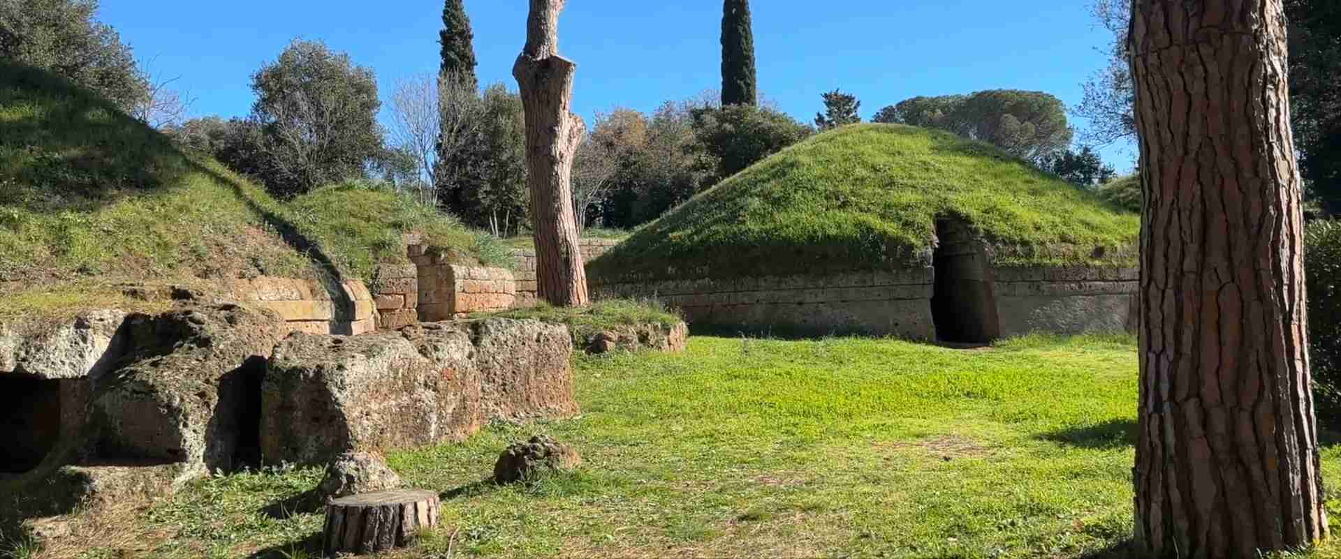
- The Banditaccia Necropolis extends across approximately 400 hectares, making it one of the largest ancient cemeteries known; the 10 hectares accessible to visitors contain around 400 burial mounds and a road network spanning nine centuries of funerary use.
- Ignimbrite tufa, the volcanic rock underlying the Cerite tablelands, is soft enough to cut with iron tools yet adequate in compressive strength for walls and tomb ceilings — a combination enabling Etruscan builders to quarry, cut drainage channels, and drive underground tunnels as integrated operations within the same landscape.
- Rock-cut drainage features (referred to in Italian archaeological literature as cavae) were systematically cut around burial mounds at Banditaccia, diverting surface water away from tomb structures and protecting ignimbrite drum bases from saturation and differential erosion.
- The Etruscans built cuniculi — underground drainage tunnels cut through tufa with ogival cross-sections — across the territory of southern Etruria; Sheldon Judson and Anne Kahane’s foundational 1963 study in the Papers of the British School at Rome places Caere explicitly within the zone of this engineering tradition, and Etruscan hydraulic works have been documented specifically on the Ponte Coperto stream at Cerveteri.
- The city walls of Caere, traced for a circuit of approximately four miles with eight documented gateways, combined artificial opus quadratum masonry in dressed tufa blocks with natural escarpment edges as an integrated defensive perimeter — a strategy that minimised costly stone construction while exploiting the landscape’s existing hydraulic geometry.
People Also Ask About Etruscan Hydraulic Engineering at Caere
What engineering techniques did the Etruscans use to manage surface water at Cerveteri?
Etruscan water management at Caere operated on two distinct spatial levels: open surface channelling and underground drainage. At the Banditaccia Necropolis, rock-cut channels and hollows in the tufa around burial mounds diverted rainwater and concentrated runoff away from tomb chambers and the bases of large tumuli. These surface features complement the broader Etruscan tradition of cuniculi — underground tunnels cut through tufa to carry groundwater and subsurface runoff away from inhabited and ceremonial areas. Judson and Kahane’s foundational 1963 study in the Papers of the British School at Rome places Caere within the documented zone of cuniculus development in southern Etruria, and subsequent research has confirmed Etruscan hydraulic works on the streams adjacent to Cerveteri. Together, surface diversion and underground drainage constituted an integrated hydrological management strategy adapted to the permeable and erosion-prone character of ignimbrite tufa.
How did drainage channels protect Etruscan burial mounds from structural degradation?
Ignimbrite tufa, while strong in compression and workable with iron tools, is vulnerable to sustained water contact: moisture migrates through its pore network, freeze-thaw cycling widens internal fractures, and concentrated runoff erodes exposed faces over decades. The tumuli at Banditaccia — earthen mounds over rock-cut tomb chambers, encircled by dressed tufa drum bases — were exposed to exactly these risks. Rock-cut drainage channels around the perimeters of burial mounds intercepted surface water before it could saturate the mound base or pond against the tufa drum. By guiding runoff laterally and away from the structure toward lower ground, the channels reduced both moisture ingress into chamber walls and the erosive force of concentrated sheet flow against the drum base. The same hydraulic logic that governed channel placement — capturing and redirecting water before it could find uncontrolled paths — appears in several documented forms across the Banditaccia landscape, from the moat-like depressions beside major tumuli to the slightly recessed road surfaces that conducted runoff along the necropolis street network.
What quarrying methods did Etruscans use when working in ignimbrite tufa beds?
Quarrying ignimbrite tufa exploited the stone’s relatively low tensile strength and its tendency to fracture along planes when subjected to localised stress. Etruscan quarry workers cut initial defining channels using iron picks and chisels, isolating a block on multiple sides; a series of wedge sockets was then cut into a face of the defined block and iron or wooden wedges were driven in to generate controlled splitting pressure. Wooden wedges expanded when wetted, allowing gradual crack propagation without the dynamic shock that could cause irregular fracture. Lever holes near block edges provided purchase for pry-bars to break the block free and manoeuvre it for transport. The regularity of cut marks observable in surviving quarry faces across the Cerite territory — consistent tool mark angles, channel widths, and socket spacing — indicates that Etruscan quarrymen worked from planned extraction sequences rather than opportunistic removal, maximising yield and minimising waste of a material that served simultaneously as building stone and as drainage infrastructure through the very act of its removal.
How does Etruscan hydraulic engineering at Caere compare to other ancient civilisations?
The most instructive cross-cultural parallels are found in civilisations that independently developed sophisticated water management in rock-cut stone landscapes facing similar hydrological constraints. Nabataean Petra, in what is now southern Jordan, combined ceramic conduit pipelines, rock-cut channels along cliff faces, diversion dams across seasonal watercourses, and bedrock cisterns into a documented hydraulic system beginning around the 4th century BC and studied comprehensively in Charles Ortloff’s 2005 analysis in the Cambridge Archaeological Journal. At Tipon, near Cusco in the Peruvian Sacred Valley, the Inca built precisely cut stone channels that still carry water today, a hydraulic achievement recognised by the American Society of Civil Engineers in 2008 as an International Historic Civil Engineering Landmark. What is significant in comparing these three traditions is not shared influence — Caere, Petra, and Tipon developed entirely independently — but convergent engineering reasoning applied to analogous geological and hydrological circumstances. Rock-cut hydraulics emerge wherever civilisations face both abundant workable stone and episodic surface water requiring systematic control.
Extended multi-day tours – 5+ days
Featured Lazio Marche Abruzzo Multi-Day Tour Packages
3 days
Lazio Marche Abruzzo 3-Day Discovery Tour
- ✓ Comprehensive Lazio Marche Abruzzo experience
- ✓ Expert local guides included
- ✓ All accommodation included
- ✓ Transportation provided
5 days
Lazio Marche Abruzzo 5-Day Highlights Experience
- ✓ Comprehensive Lazio Marche Abruzzo experience
- ✓ Expert local guides included
- ✓ All accommodation included
- ✓ Transportation provided
7 days
Lazio Marche Abruzzo 7-Day Cultural Journey
- ✓ Comprehensive Lazio Marche Abruzzo experience
- ✓ Expert local guides included
- ✓ All accommodation included
- ✓ Transportation provided
10 days
Lazio Marche Abruzzo 10-Day Complete Adventure
- ✓ Comprehensive Lazio Marche Abruzzo experience
- ✓ Expert local guides included
- ✓ All accommodation included
- ✓ Transportation provided
Multi-day tour packages powered by TourRadar. Prices and availability subject to change.
The Geological Foundation: Ignimbrite Tufa and the Cerite Landscape
The landform on which Caere was built is not arbitrary. It is a direct product of the Sabatini volcanic complex — one of several Pleistocene volcanic centres in what is now northern Lazio — whose eruptive history deposited ignimbrite sheets across thousands of square kilometres of the Tyrrhenian coastal zone. Ignimbrite is a pyroclastic flow deposit: the welded or partially welded product of a fast-moving mixture of hot volcanic gas and rock fragments that spread across the landscape during major explosive eruptions and consolidated as it cooled. The result is a rock of intermediate density and internally variable texture — denser and more homogeneous at the base of thick flow units, more vesicular and fragile nearer the surface.
In the Cerveteri area, the primary engineering stone is the grey ignimbrite tufa locally designated tufo grigio di Cerveteri. This rock presents a mechanical character that Etruscan builders exploited with considerable sophistication. In compression — bearing vertical loads — it is adequately strong for walls, tomb ceilings of modest span, and retaining structures. In tension, however, it is brittle and prone to cracking along pre-existing fracture planes. It absorbs water readily through its pore network, with moisture contents that fluctuate significantly between wet and dry seasons. When saturated tufa is subjected to freezing temperatures, internal water expands, progressively widening microfractures. Repeated wetting and drying cycles cause surface spalling and delamination. And when concentrated surface water runs across exposed tufa faces, the mechanical abrasion of suspended sediment removes material at rates that, across centuries, substantially reshape landscape features.
The physiography of the Cerveteri area reflects millennia of this process. The tufa landscape presents a classic plateau morphology: a series of elevated flat-topped tablelands separated by deep, steep-sided ravines carved by seasonal streams. The plateaus offered defensible high ground with reliable building material immediately beneath the surface; the ravines functioned as natural moats and drainage conduits for the surrounding territory. The city of Caere occupied one such plateau, 80 metres above sea level, bounded by the rivers Mola and Manganello and oriented from northeast to southwest. The sources indicate it was “isolated except on the northeast” — meaning the natural escarpments provided continuous protection on most of the circuit, with only the northeastern approach requiring deliberate artificial defence. The Banditaccia Necropolis occupies a separate adjacent plateau, separated from the inhabited city by one such ravine system.
This geological and topographic reality determined, in fundamental ways, how Etruscan engineers approached water management. Rainfall on the flat plateau surface accumulated as runoff that could flow only toward the plateau edges or through whatever internal drainage the engineers provided. The tufa subsoil, while permeable, had an infiltration limit beyond which rainfall rates exceeded absorption and water ran off across the surface in concentrated sheets. In the necropolis, where earthen tumuli and partially buried drum bases presented complex surface geometries collecting water from large catchment areas, controlling this runoff was not a marginal concern but a primary engineering necessity.
The geology also determined the character of the available engineering responses. Because ignimbrite tufa is readily cut with iron tools, drainage channels, underground tunnels, and quarry cuts were all achievable by skilled workers using relatively simple implement sets. Stone quarried from the plateau for building simultaneously shaped drainage geometry. The tool marks, socket patterns, and channel profiles left in surviving quarry faces are therefore direct evidence of engineering planning, not merely mining activity.
Engineering Logic of a Volcanic Plateau: How Caere’s Topography Shaped Its Infrastructure
One of the most clarifying insights for understanding Etruscan engineering at Caere is recognising that the builders worked predominantly in negative space. Where many ancient construction traditions accumulate material upward, Etruscan builders at Caere cut downward: into the tufa plateau to create tomb chambers, into escarpment faces to define wall alignments, and into the bedrock around burial structures to control water. The removal of material served multiple simultaneous purposes — producing usable building stone, shaping drainage geometry, and defining spatial boundaries — in a manner that resists easy separation into “quarrying” and “engineering” as distinct operations.
The spatial logic of Caere’s infrastructure reflects this multi-purpose approach consistently. The hollows left by extracting building stone from the vicinity of a tumulus simultaneously became drainage channels for the mound’s perimeter once the building phase concluded. The cuts made to define a cliff face for a wall alignment also regularised the escarpment’s drainage characteristics, channelling water in predictable directions rather than allowing uncontrolled flow over newly worked stone faces. The underground cuniculi that drained subsurface water from the inhabited plateau and its agricultural hinterland yielded tufa debris as fill or aggregate. In a landscape where labour was the limiting factor and raw material was immediately underfoot, an engineering approach that extracted value from every cubic metre of removed stone was both economically rational and practically elegant.
This integrated approach should not be mistaken for undifferentiated practice. Quarrying regularised blocks for gateway construction, cutting drainage channels around tomb perimeters, driving cuniculus tunnels, and dressing wall courses in opus quadratum were technically distinct operations demanding different tools, different workforce skills, and different standards of geometrical precision. What unifies them is a consistent engineering philosophy: use the existing rock as both material and form, convert the necessary removal of stone into positive drainage and structural outcomes, and integrate topographic features — escarpments, ravines, natural drainage lines — into the built infrastructure wherever possible.
The scale of this engineering deserves emphasis. The Banditaccia Necropolis extends across approximately 400 hectares in its full extent — one of the largest ancient cemeteries known — of which only around 10 hectares are currently excavated and accessible to visitors. The tomb structures visible today — the large tumuli of the Orientalising and Archaic periods, the later chamber tomb types cut directly into the plateau, the regularised road network of the necropolis, including the main burial route first documented by archaeologist Raniero Mengarelli and known as the Via degli Inferi (the Way of the Underworld) — represent the visible product of sustained, organised labour across several centuries. Hydraulic management across this landscape was not incidental maintenance: it was a planned infrastructural undertaking demanding the same organisational capacity as the tomb construction itself.
The Hydraulic Cutouts (Cavae) and Runoff Diversion Channels around Burial Mounds
Around the major tumuli of the Banditaccia Necropolis, the tufa bedrock shows evidence of systematic hydraulic intervention. The term cavae — drawn from the Latin for hollows or cuttings — appears in Italian archaeological literature to describe open rock-cut features adjacent to burial structures, a category that encompasses both the quarry hollows from which building stone was extracted and the drainage channels that the extraction process, and subsequent deliberate cutting, created alongside standing tomb structures. The two functions are inherently difficult to disentangle in the physical record. The oldest area of the necropolis is itself named the Cava della Pozzolana — a designation that preserves the term’s original quarrying meaning while also acknowledging the hollow’s role in the landscape’s drainage geometry. In Banditaccia’s internal topography, a quarry cut beside a tumulus base is simultaneously a drainage channel once the building phase is complete, without requiring any additional intervention.
The hydraulic features around burial mounds at Banditaccia take several forms. Open rock-cut channels, typically of modest cross-section, follow the base perimeters of tufa drum structures, intercepting surface runoff from the mound face and the surrounding ground surface. Rock-cut steps and terraced cuts on the upslope sides of tumuli deflect water around the structure rather than allowing it to concentrate against the mound’s base. In some instances, the quarried depressions beside major tombs create a shallow moat-like geometry that collects and temporarily holds runoff before it can migrate toward tomb chamber walls. The road surfaces of the necropolis — including the Via degli Inferi running more than two kilometres through the accessible portion of the site — are cut slightly lower than the surrounding tomb platforms, a geometry that simultaneously served movement and hydraulic distribution, gathering runoff from tomb platforms and mound surfaces and conducting it toward natural drainage lines at the plateau edge.
Preventing Structural Degradation of Ignimbrite Tufa through Drainage Channels
The structural threat that water poses to ignimbrite tufa construction is not speculative: it is demonstrated by the differential preservation of protected and unprotected tufa surfaces at Banditaccia and at comparable Etruscan sites across southern Etruria. Tufa exposed to concentrated water flow, seasonal ponding, or prolonged ground moisture undergoes a sequence of degradation that begins invisibly — moisture migrating through the pore network, mineral salts in solution following water pathways and crystallising at evaporation surfaces — and progresses to visible spalling, delamination along internal fracture planes, and eventual loss of surface coherence. The tufa drum bases of major tumuli were particularly vulnerable: if their lower courses became persistently saturated, the compressive capacity of the outer face would diminish progressively, with consequences for the structural stability of the earthen mound above.
Rock-cut drainage channels around burial mounds interrupt this degradation sequence at its first stage by preventing the accumulation of standing water against the structure and reducing the moisture head available to drive capillary ingress. A channel cut at the base of a tufa drum, with its floor lower than the drum’s foundation course, creates a hydraulic break: surface water intercepted by the channel is conducted laterally and away from the structure before it can pond or saturate the adjacent stone. The channel also removes water from the contact zone between natural tufa bedrock and the cut stone courses of the drum, where differential drainage rates between the two surfaces could otherwise create conditions for accelerated weathering at the joint.
The dimensions of these channels, where they survive with sufficient preservation to be observed, are characteristically modest: adequate to carry the peak surface runoff from the mound face and the immediately surrounding area, but not engineered as major water conduits. The gradients of channel sections in the Banditaccia landscape generally follow natural drainage slopes, suggesting the primary engineering logic was to align drainage features with pre-existing water pathways rather than to impose artificial slopes requiring significant cut depth. Where the natural gradient was insufficient, channel floors were cut slightly below the surrounding surface to maintain adequate hydraulic velocity for sediment transport and to prevent silting that would progressively reduce channel capacity.
A secondary benefit of systematic drainage provision — one that is not always foregrounded in general accounts of the necropolis — was the management of hydraulic relationships between adjacent tombs. The Banditaccia Necropolis is not a random accumulation of isolated monuments: it is a planned landscape with defined routes and zones in which the drainage relationship between neighbouring structures was a practical concern. Water draining from one tumulus should not pond against its neighbour’s drum base. The channel system around individual tombs, where consistently applied, thus constitutes a necropolis-wide hydraulic infrastructure rather than a series of independent monument-protection measures.
Ongoing maintenance was almost certainly required to preserve hydraulic effectiveness across the site’s centuries of active use. Accumulated sediment progressively reduces channel capacity; root intrusion from vegetation on mound surfaces cracks tufa channel walls; vegetation on the mounds themselves modifies runoff rates. The evidence of continued tomb use and modification at Banditaccia — later tomb types inserted into earlier sections, pathways maintained, facades periodically repaired — implies an organisational capacity for site management that would logically have extended to hydraulic maintenance, though specific ancient maintenance practices are not recoverable from the archaeological record alone.
Quarrying Techniques: Wedge Sockets and Block Extraction Geometry in Tufa Beds
Etruscan quarrying of ignimbrite tufa at Caere and across its territorial hinterland left physical signatures in surviving quarry faces and in the cut marks observable on unfinished or abandoned blocks at several locations in the Cerite landscape. These signatures constitute a primary source for understanding ancient technique, since no ancient manual of Etruscan stoneworking survives and the Roman-period writers who describe stone quarrying do so primarily for different geological contexts. The tufa quarry record must accordingly be read directly from the stone itself.
The fundamental extraction sequence for large tufa blocks appears to have proceeded in broadly consistent stages across Etruscan quarry sites of central Italy, with Cerite examples sharing the general technical vocabulary. Workers first cut defining channels around the perimeter of the intended block using iron picks and flat-ended chisels, isolating it from the surrounding mass on its accessible faces. These defining channels are characteristically narrow relative to their depth — wide enough for a worker’s arm and tool, but no wider than the minimum required — reflecting an awareness that material removed in channelling was building-stone grade material irreversibly wasted.
Where the block face coincided with a natural vertical joint in the tufa, that joint was exploited as a ready-made separation plane, with channelling required only on the remaining sides. Natural fracture planes in ignimbrite — produced by cooling contraction during original pyroclastic emplacement — are common features of the rock’s internal structure, and experienced quarrymen would have read the jointing pattern before committing to block geometry, selecting orientations that minimised required cutting while maximising the regularity of the extracted block.
Wedge sockets — small rectangular or trapezoidal recesses cut in series along intended splitting lines — are the most diagnostic evidence of ancient controlled splitting technique. These sockets are typically spaced at intervals along the splitting line (the exact spacing varied with local rock character and the distance over which the split needed to propagate), and received either iron wedges or wooden wedges depending on the working context. Iron wedges were driven with hammers to generate immediate, concentrated splitting force. Wooden wedges, when saturated with water, expanded as wood fibres absorbed moisture, generating slow, sustained lateral pressure that allowed crack propagation to follow the planned path without the dynamic shock that could cause irregular fracturing. Both methods produced predictable fracture lines along the wedge socket series, releasing the block from its bed along a relatively planar base surface.
Lever holes — circular or oval cut recesses near block edges — complemented the wedge system by providing purchase for iron or wooden pry-bars used to break the block free after splitting and manoeuvre it for placement on sledges or rollers for transport. The spatial relationship between wedge sockets and lever holes observed on surviving quarry faces reflects planning: the sockets define the splitting line, and the lever holes are positioned to give maximum mechanical advantage once the split is completed.
The geometry of block extraction in tufa beds also reflects a concern with yield. Step-quarrying — working the quarry face in horizontal benches rather than attacking it from a single height — was used to extract blocks of consistent course height suitable for ashlar construction, with the bench height corresponding to the desired block height. This approach reduces finishing labour, produces the dimensional consistency required for opus quadratum construction, and allows the quarry face to advance in a controlled, repeatable manner. The quarry faces adjacent to construction sites at Banditaccia preserve sufficient of the original bench geometry, where vegetation and later weathering have not obscured it, to suggest this step-quarrying approach was employed, and the same technique is attested at comparable Etruscan quarry contexts across southern Etruria.
The dual hydraulic-quarrying function of these cuts means that the quarry record at Banditaccia is also a hydraulic record. Every channel cut to define a block edge was a potential drainage feature once the stone was removed. Every bench cut to extract a row of drum base blocks was a terrace that modified the slope’s runoff geometry. The archaeological evidence does not distinguish these functions because the builders apparently did not need to: the act of removing stone for construction simultaneously produced drainage infrastructure as a material consequence.
Cuniculi and Underground Water Management in Ancient Etruria
Among the most technically impressive achievements of Etruscan hydraulic engineering — and the category that has attracted sustained scholarly attention since the foundational 1963 study by Sheldon Judson and Anne Kahane in the Papers of the British School at Rome — is the cuniculus: an underground drainage tunnel cut entirely through solid tufa or comparable rock. The cuniculus (plural cuniculi) differs from a buried pipe or a lined channel in that it is a true tunnel cut through the living rock with hand tools, tall enough in many examples for a worker to move through in a crouched or bent posture, and maintained by access shafts sunk from the surface at intervals along its length. Judson and Kahane’s study explicitly places Caere within the documented zone of cuniculus development on the southern flanks of the Sabatini volcanic complex, and subsequent research has confirmed Etruscan hydraulic works on streams in the Cerite territory itself.
The documented dimensions of Etruscan cuniculi vary with site geology and function. At Perugia, cross-sections are elongated with ogival vaults reaching approximately 1.7 to 1.8 metres in height and 0.7 to 0.8 metres in width — sufficient for a worker to move through, crouched, for maintenance operations. Narrower examples, such as the San Potente cuniculus in the Tuscania region, reach only 0.3 to 0.4 metres in width, small enough for hand tools but not for an adult worker to enter upright. The gradient of cuniculi was typically kept in the range of 1 to 2 per cent to promote natural water flow without causing erosive velocity — a choice that required accurate gradient measurement over distances of several hundred metres in complete or near-complete underground darkness.
Construction proceeded through a combination of horizontal excavation from the ends and vertical shaft sinking from the surface. The shafts, sunk at intervals typically ranging from around 30 to 40 metres, served three concurrent purposes during construction: they removed excavated material from the underground to the surface; they provided ventilation to allow workers in the gallery to breathe; and they allowed surveyors at the surface to verify alignment and gradient before the gallery sections between shafts met. Once the tunnel was operational, the same shafts provided maintenance access for periodic clearance of sediment accumulation that would otherwise reduce hydraulic capacity. The shafts’ regular spacing gives cuniculi their characteristic dotted-line appearance when visible in aerial or satellite imagery of the Roman Campagna.
At Veii — Caere’s sometime rival and the Etruscan city best documented for cuniculus engineering — approximately 22 kilometres of cuniculi have been discovered. The 70-metre Ponte Sodo tunnel is among the most visually striking surviving examples. A 2025 mapping project, a collaboration between the National Etruscan Museum of Villa Giulia, the Chair of Etruscology at Sapienza University of Rome, and the Italian Ministry of Culture, achieved the first comprehensive documentation of the cuniculus network beneath the Sanctuary of Portonaccio at Veii using autonomous survey rovers, producing a detailed plan of an underground system comprising galleries, cisterns, wells, and water management structures. This project illustrates both the complexity of what these systems could achieve and the extent to which their full extent remains to be mapped even at the best-studied Etruscan sites.
The uses to which cuniculi were put were multiple. Drainage of subsurface water from inhabited plateaus — removing groundwater that would otherwise undermine foundations or contribute to slope instability at escarpment edges — was a primary function. Agricultural water management in the hinterland of Etruscan cities, including the irrigation of lowland fields in dry seasons and the drainage of seasonally waterlogged areas, was another. Livy records that cuniculi were also used for military purposes, to drive tunnels beneath besieged city walls — a use that illustrates the technique’s versatility beyond the hydraulic domain. Franco Ravelli and Paula Howarth’s research on cuniculi across Etruria and Latium placed their construction in a span roughly from the 8th through the 3rd or 4th centuries BC, encompassing the period of Caere’s greatest political and economic power.
The overlap between cuniculus drainage and surface quarrying within the Cerite landscape illustrates once more the integration of functions in Etruscan stone-working practice. A cuniculus cut to drain subsurface water simultaneously removes building stone in the form of cut tufa debris. A drainage channel cut at the surface simultaneously defines a boundary and provides a quarry cut. The categories that modern classification systems tend to maintain as separate — quarrying, drainage engineering, landscape modification — were in the Etruscan practice of Caere intermeshed aspects of a single material culture of stone management.
The City Walls of Caere: Defense Systems along Perpendicular Tufa Escarpments
The defensive perimeter of ancient Caere exploited its topographic situation with characteristic Etruscan efficiency. The city’s plateau was bounded by the rivers Mola and Manganello and, according to the ancient and archaeological record, “isolated except on the northeast” — meaning the natural escarpments provided continuous protection along most of the circuit, with only the northeastern approach requiring deliberate artificial fortification. The line of the walls, built of rectangular blocks of tufa and traceable for a circuit of approximately four miles, was documented by 19th-century scholars to include what appear to have been eight gateways. The medieval builders of Cerveteri subsequently quarried the Etruscan fortification for their own walls: a 19th-century account of Cerveteri notes that the walls built by the city’s later Orsini lords rose along the hill’s crest, constructed from the large orange-coloured tufa blocks taken from the Etruscan fortifications below — direct physical evidence that dressed tufa blocks from the Etruscan wall circuit survived into the medieval period in sufficiently large quantities for wholesale reuse.
The strategic calculation underlying this defensive perimeter is clear from the surviving evidence. An attacking force attempting to scale a sheer tufa escarpment face several metres high would face severe disadvantages against defenders on the plateau edge. The primary task of the Caere fortification engineers was therefore not to build a complete continuous artificial wall of uniform section, but to supplement natural defences with worked masonry only where the topography provided insufficient natural protection: at gateway approaches, saddle points, and locations where the plateau edge had eroded to a gradient rather than a cliff.
Dry-Stone Opus Quadratum Gateways and Ravine-Block Fortifications
Opus quadratum — the masonry technique in which regularised rectangular blocks are laid in horizontal courses, typically without mortar or with only minimal lime binding at later phases — was employed for the gateway structures and the most demanding sections of Caere’s artificial wall. The technique is attested in tufa at Caere alongside other southern Etruscan cities including Veii and Vulci, though one persistent challenge in the archaeological study of these walls is that opus quadratum construction in tufa at these sites is often difficult to distinguish between the Etruscan-period founding phases and subsequent Roman-period additions or repairs. The scholarly consensus is that dry-laid courses characterise at least the earlier Etruscan phases, while later modifications — particularly after the city came under Roman influence from the 4th century BC onward — may have introduced lime mortar at some sections.
The engineering requirements of gateway construction in this tradition were considerable. A gateway interrupts the wall line and creates a structural discontinuity that must be resolved in both structural and hydraulic terms. Structurally, the opening requires jambs adequate to support whatever arch or lintel spans the road width, and these jambs must transmit the concentrated loads from the wall above to the bedrock below without differential settlement. Hydraulically, the gateway approach is often a natural water-collection point, since it is typically located at a lower point in the perimeter where access is easiest — which is also where water drains. The gateway approaches at Caere were accordingly subject to surface water management beyond those of the general plateau wall circuit, and the physical evidence at comparable Etruscan gateway sites indicates that paved approach surfaces and cut drainage features were standard elements of gateway design.
The ravine edges of the Cerite plateau served as what the brief for this article aptly terms “ravine-block fortifications”: the natural escarpment face, where steep enough to be militarily impassable without equipment, functioned as the defensive wall. At points where seasonal erosion had reduced the face from a cliff to a slope, additional quarry cutting was sometimes applied to steepen the face artificially — converting passive natural topography into an actively engineered defensive feature. This approach again exemplifies the dual-purpose logic: the material removed in steepening an escarpment face was usable building stone, the drainage pattern of the ravine below was modified by the changed face geometry, and the military effectiveness of the perimeter was enhanced without requiring the construction of an additional wall section.
The hydraulic dimension of Caere’s defensive perimeter is often overlooked in accounts focused on military function. The ravines bounding the city plateau were not merely convenient natural moats; they were active drainage conduits for the plateau’s surface water. The management of these ravines — maintaining clear, functional drainage paths and preventing the silting that would pond water against the escarpment base and accelerate undercutting — was therefore an integral concern of the city’s engineering management, not a separate hydraulic problem. The Etruscan maintenance of ravine drainage capacity is consistent with the broader pattern of active hydraulic management visible across the Cerite landscape.
Dating the construction phases of Caere’s walls with precision remains difficult. The general historiographic framework, derived from ceramic evidence at construction levels and typological comparison with better-documented Etruscan and early Roman walls elsewhere in central Italy, places the primary defensive building in a range roughly spanning the 5th to 3rd centuries BC — the period of Caere’s mature political development as an independent city-state, before and after its complex accommodation with expanding Roman power. Wall modifications and repairs continued into the Roman period, and the structural sequence at any surviving section reflects this extended history of use and reworking.
Cross-Cultural Hydraulic Parallels: Nabataean Petra and Inca Tipon
The most illuminating framework for understanding Etruscan hydraulic engineering at Caere is comparison with other civilisations that independently developed sophisticated water management in rock-cut or mountainous stone landscapes facing analogous hydrological constraints. Two traditions offer particularly instructive parallels: Nabataean Petra in the southern Levant, and the Inca hydraulic complex at Tipon near Cusco. The essential point must be stated at the outset: these parallels represent convergent independent engineering reasoning, not shared influence, shared cultural ancestry, or any form of technological transmission. No historical or archaeological evidence connects Etruscan Caere with Nabataean Petra or with Inca Tipon; the interest of the comparison lies precisely in what it reveals about universal engineering logic applied independently to similar material conditions.
Nabataean Petra, whose hydraulic system is comprehensively documented in Charles Ortloff’s 2005 analysis in the Cambridge Archaeological Journal (volume 15, issue 1), was built in a landscape of red sandstone massifs in what is now southern Jordan. Nabataean engineers facing a desert environment where water was scarce and flash floods destructive developed a complete hydraulic toolkit. Terracotta pipeline systems conducted spring water from source points across cliff faces and through the city. Rock-cut open channels followed gradient contours across sandstone faces with surveying precision, sometimes for several kilometres. Diversion dams across seasonal watercourses (wadis) captured floodwater for storage or agricultural use. Cisterns cut into bedrock, some with sedimentation basins at their narrow entrances to purify incoming water, provided strategic reserves. The common architectural vocabulary — rock-cut channel, bedrock cistern, diversion feature — maps coherently onto the Etruscan toolkit despite the radically different geological medium (sandstone versus tufa) and climatic context (hyperarid desert versus sub-Mediterranean).
At Tipon, located approximately 22 kilometres south-east of Cusco in Peru’s Sacred Valley region, the Inca constructed a hydraulic complex recognised in 2008 by the American Society of Civil Engineers as an International Historic Civil Engineering Landmark — a designation explicitly acknowledging it as a “Masterpiece of Hydraulic Engineering of the Inca Empire.” The site features finely cut stone channels maintaining precisely surveyed gradients for the controlled distribution of water from a natural spring source across a series of ceremonial and agricultural terraces. The precision of the stone cutting at Tipon — channels maintaining regular cross-section dimensions and consistent gradient over long runs — and the fact that many of the original channels still carry water today, demonstrates that Inca hydraulic engineering achieved a level of durability and accuracy that modern engineers studying the site continue to examine for insights into gradient management and controlled flow distribution. The engineering challenge being solved at Tipon — distributing a limited upslope water source efficiently across a large terraced area without erosive loss — is structurally different from Caere’s runoff management problem, but the shared solution logic of cutting precisely graded stone channels to control water movement connects the two traditions.
What these three independent traditions share — and what distinguishes them from civilisations that managed water primarily through above-ground masonry infrastructure — is a systematic exploitation of the natural rock as both medium and material. Cutting into rock to form channels, cisterns, conduits, and drainage features is simultaneously a quarrying act and a hydraulic engineering act. The rock removed creates the hydraulic form; the rock retained provides the structural housing for the water management function. This dual-nature extraction logic, which operates at Caere in the relationship between quarrying and drainage around tumuli, recurs at Petra in the relationship between cliff-face working and conduit creation, and at Tipon in the relationship between terrace-cutting and channel formation. Convergent engineering reasoning, applied to analogous geological opportunity, produced analogous solutions in three geographically separated and culturally independent civilisations.
The Banditaccia Necropolis as an Engineered Funerary Landscape
Understanding the hydraulic engineering of Banditaccia requires situating it within the overall spatial organisation of the necropolis as a planned landscape rather than treating drainage features as incidental to the funerary program. The Banditaccia Necropolis is one of the largest and best-preserved Etruscan burial grounds known, with its total extent of approximately 400 hectares encompassing thousands of burials spanning from the 9th century BC through the Hellenistic and Roman periods. The planning visible in the excavated portion reflects a consistent spatial logic across this span of time, in which tomb structures of different periods and typologies were laid out along defined routes in a manner that has often been compared, both in scale and organisational character, to an urban plan — a city of the dead mirroring, in its spatial organisation, the city of the living on the adjacent plateau.
The oldest and most visually dominant elements of the necropolis are the large tumuli of the Orientalising and Archaic periods — roughly the 7th to early 5th centuries BC. These mounds, some reaching diameters of tens of metres and original heights of several metres, were constructed by accumulating earth over one or more rock-cut tomb chambers, encircling the base with a regularised drum of dressed tufa blocks. The drum bases of the largest tumuli represent substantial masonry undertakings in their own right, requiring the extraction, dressing, and placement of large volumes of regularised tufa block. Quarrying activity associated with tumulus construction was therefore not peripheral but spatially proximate and temporally integral: the stone for the drum came from immediately adjacent cuts, and those cuts became drainage features as soon as the construction phase concluded.
By the later 6th and 5th centuries BC, tomb typology at Banditaccia shifted toward hypogeum-style chamber tombs cut directly into the plateau surface, without earthen covering mounds. These tombs, accessible via stepped dromos passages cut into the tufa, place the entire tomb chamber at or below ground level. Their hydraulic management focused on the dromos, which presented a natural water-collection slot in the plateau surface, and on the junction between the cut passage walls and the surrounding tufa, where water infiltration into the chamber could occur if the junction geometry allowed ponding. The physical evidence suggests that dromos drainage was addressed through gradient cutting of the passage floor, conducting infiltrating water toward the outer end of the dromos away from the chamber entrance.
The accessible portion of the Banditaccia road network — with defined routes running between tomb complexes, including the Via degli Inferi more than two kilometres in extent — implies a managed spatial relationship between adjacent structures that extends to hydraulic considerations. The roads are cut slightly lower than the surrounding tomb platforms, a geometry that functions simultaneously as movement corridor and as hydraulic distribution channel, gathering runoff from tomb platforms and mound surfaces and conducting it toward the plateau edges and natural drainage lines. The necropolis street network thus constituted a hydraulic distribution system at the landscape scale, not merely a series of individual monument-protection measures.
The tomb interiors themselves reflect hydraulic engineering in ways that are less immediately visible than the external drainage features. The characteristic domestic interior of the large Archaic chamber tombs — with carved ceiling beams, door mouldings, and pitched ridge shapes imitating house architecture in tufa — includes roof geometry that would have shed condensation and any minor infiltration toward the chamber walls and floor rather than allowing it to collect at the ceiling-wall joint. The rock-cut benches along chamber walls served funerary functions but also elevated grave goods and human remains above any minor floor moisture. These internal features constitute an environmental management system embedded in the architectural program, not supplementary additions.
Materials Science of Ignimbrite Tufa: Workability, Porosity, and Structural Behaviour
The physical properties of ignimbrite tufa explain why it dominated Etruscan construction at Caere across so many centuries and construction types, from tomb chamber ceilings to city wall sections to drainage channel linings. These properties are not merely background context for the engineering decisions visible at the site; they are the material logic that those decisions responded to and, in some cases, deliberately exploited.
Fresh ignimbrite tufa, particularly when first exposed by quarrying from depths below the oxidised surface layer, is relatively soft — workable with iron tools in ways that harder rocks like granite or limestone would not permit without substantially greater effort and more robust implements. This freshly quarried stone can be shaped with precision using chisels and picks whose iron hardness is only modestly greater than the stone’s own. As the cut stone dries after quarrying, the volcanic glass matrix of the ignimbrite continues a slow mineralogical maturation, producing hardening over weeks and months of air exposure — a phenomenon consistent with what modern studies of volcanic glass devitrification would predict. Ancient builders appear to have been aware of this effect at some level of practical knowledge, given the common observation across Etruscan construction sites that blocks quarried and seasoned before final placement exhibit better long-term performance than blocks placed immediately from the quarry face.
The porosity of ignimbrite tufa is one of its defining engineering characteristics. In drainage channel walls, porosity means that water can infiltrate through the channel lining into the surrounding rock mass, which is generally beneficial for sub-surface drainage purposes: the channel conducts concentrated runoff while the surrounding tufa absorbs distributed groundwater, so the two systems complement each other. In load-bearing wall blocks, the same porosity means that capillary moisture can migrate through the wall body, potentially transporting soluble salts and accelerating surface deterioration over cycles of wetting and drying. Managing moisture through tufa structures — keeping it where beneficial and limiting it where damaging — was an ongoing practical challenge that the drainage systems described in this article addressed at the landscape scale.
Compressive strength values for ignimbrite tufa of the Cerveteri type are adequate for the load-bearing demands of tomb chamber ceilings of modest span, retaining walls, and urban defensive walls of the scale documented at Caere. The critical structural failure mode is not compressive crushing but tensile fracture: the rock’s tendency to crack along planes when subjected to bending stress, lateral force, or the expansion of water freezing within pore spaces. Etruscan construction at Caere addresses this vulnerability through choices that are intuitive rather than analytically expressed. Tomb ceilings use the corbelling technique or simple rectangular lintels that avoid tensile bending across wide spans. Wall blocks in opus quadratum are oriented with their strongest face perpendicular to the primary load. Drainage channels are cut to avoid concentrated water ponding that would maximise freeze-thaw cycling against tufa walls. Each of these choices reduces the probability of the dominant failure mode without requiring the builders to have formulated the physics of tensile fracture in explicit analytical terms.
The relationship between tufa’s thermal properties and its engineering use deserves brief note. Ignimbrite tufa has relatively low thermal conductivity compared to denser rock types, which means that Etruscan tomb chambers cut into the plateau experience a stable sub-surface temperature with minimal seasonal variation. This thermal stability was presumably experienced empirically as a property of underground space rather than understood analytically, but it contributed to the conditions that have preserved organic grave goods — including textiles, wood, and foodstuffs — in some Banditaccia tombs over two and a half millennia. The same thermal mass that made underground chambers comfortable for Etruscan rites of passage continues to moderate the temperature environment for the archaeological materials within.
Conservation and Heritage Significance: The Etruscan Necropolises of Caere and Tarquinia
The Etruscan Necropolises of Cerveteri and Tarquinia were jointly inscribed on the UNESCO World Heritage List in 2004, the first inscription specifically recognising the archaeological and cultural importance of Etruscan civilisation. For Cerveteri, the Banditaccia Necropolis was cited for its exceptional state of preservation, its scale and typological variety, and the evidence it provides for Etruscan urban planning, social organisation, and artistic achievement. The shared inscription with Tarquinia acknowledges the complementary character of the two sites: Cerveteri’s tombs are distinguished by their architectural elaboration and spatial planning, while Tarquinia’s are celebrated for their painted interiors depicting scenes from Etruscan daily and ritual life.
The hydraulic engineering discussed in this article is an active concern for the ongoing conservation of the Banditaccia site, not merely a historical subject. Water management remains a primary conservation challenge. The same hydrological processes that Etruscan engineers managed through drainage channels and other hydraulic infrastructure — surface water concentration at tomb bases, subsurface moisture migration, runoff erosion at structural junctions — continue to operate and continue to threaten the preservation of tomb structures. Many of the ancient drainage channels have become partially silted, overgrown with vegetation roots, or blocked by collapsed material over the centuries of intermittent or absent maintenance that followed the site’s abandonment as an active necropolis. The hydraulic effectiveness of the original system is consequently reduced across large portions of the site that have not been actively managed.
Modern conservation programmes at Banditaccia have addressed these issues through the clearance of ancient drainage features to restore their original hydraulic function, installation of complementary modern drainage where ancient systems are irreparably compromised, and monitoring of moisture levels in tomb chambers identified as particularly vulnerable. The challenge of maintaining a hydraulically coherent drainage system across 400 hectares of partially excavated, partially unexcavated, and partially accessible archaeological landscape is formidable, and conservation resources have inevitably been prioritised toward the most significant and most actively visited portions of the site.
Ongoing archaeological research at Caere spans multiple institutional programmes. Queen’s University has been investigating the Hypogeum of Clepsina — a subterranean structure in the centre of the ancient city featuring wall paintings, inscriptions, and architectural elements — as part of the Caere Excavation Project, a programme that illustrates how much of the inhabited city remains to be explored relative to the well-documented necropolises. The site is now managed as part of the Parco Archeologico di Cerveteri e Tarquinia (PACT), an autonomous special-interest institution of the Italian Ministry of Culture, which coordinates archaeological research, conservation, and public access across both inscribed sites.
Visiting the Archaeological Sites of Ancient Caere
The primary destination for visitors interested in Etruscan hydraulic and quarrying engineering is the Banditaccia Necropolis archaeological park, located on the Via della Necropoli approximately 1.5 kilometres north-west of Cerveteri and around 48 kilometres north-west of Rome. The 10 hectares accessible to visitors include the major tumuli of the Archaic period with their tufa drum bases and associated drainage features, examples of chamber tomb types from successive periods including the corridor tombs and hypogeum-style tombs, and sections of the Via degli Inferi road network that illustrate the landscape-scale spatial and hydraulic organisation of the necropolis. Visitors who examine the tufa surfaces closely adjacent to the larger tumuli will find evidence of the quarrying and drainage cutting described in this article: channel marks, stepped quarry faces, and the geometry of rock-cut features that served both extraction and hydraulic functions without these purposes being architecturally separated.
The site is open Tuesday through Sunday. Summer hours run from 8:30 to 19:30, with the ticket office closing at 18:30; winter hours are 8:30 to 16:30. The site is closed on Mondays. Standard admission is €8, with reduced rates of €2 for minors and €5 for students (check the official PACT website or contact the site for current rates, as prices may vary). First Sundays of the month are free entry days under the standard Italian national museum policy. Periodic special openings allow entry into normally restricted tombs — in summer 2025 the site organised nine special access dates for the Tomb of Reliefs, normally visible only through anti-condensation glass.
The National Archaeological Museum of Cerveteri (housed in the Ruspoli Castle in the historic centre of Cerveteri) provides essential context for the engineering achievements described here. Its collections include objects from the Banditaccia tombs that document the wealth, artistic achievement, and broad Mediterranean connections of Caere at its apogee. The museum is an important complement to the necropolis visit, offering display material that contextualises the built remains within the social and commercial history of one of the most powerful Etruscan city-states.
Access to the Banditaccia park is by road from Cerveteri. A full visit combining the necropolis and the museum, with time to examine the hydraulic and quarrying evidence at the tomb bases and road sections, requires at minimum a full day. The site of the ancient city of Caere occupies the plateau beneath and around modern Cerveteri, and while no comprehensive urban excavation is publicly accessible, the town’s edges offer views of the plateau topography that makes the defensive and hydraulic engineering logic immediately legible: the natural escarpment edges, the ravine valleys of the Mola and Manganello, and the sharp break between the plateau surface and the surrounding landscape that explains every major engineering decision discussed in this article.
Frequently Asked Questions
What made Caere’s ignimbrite tufa landscape particularly suited to Etruscan hydraulic engineering?
Ignimbrite tufa at Caere combined properties that, taken together, were almost uniquely suited to integrated quarrying-and-drainage engineering. The stone’s relative softness when freshly quarried allowed drainage channels, underground tunnels, and building blocks to be produced using the same iron tool sets by the same workforce. Its adequate compressive strength meant that channel walls, tomb ceilings, and defensive walls could all be built from the same material without supplementing it with harder stone. Its porosity assisted sub-surface drainage by allowing the rock mass surrounding a drainage channel to absorb distributed groundwater, while the channel itself conducted concentrated surface runoff. And the flat-topped plateau morphology of the Cerite landscape — a consequence of the ignimbrite’s near-horizontal deposition — created a predictable hydrological geography in which surface water followed consistent paths to ravine edges, making systematic drainage infrastructure feasible to plan and execute.
What exactly are cuniculi and how were they constructed?
A cuniculus is an underground drainage or water-management tunnel cut entirely through solid rock — typically volcanic tufa in the Etruscan context — without masonry lining, using hand tools and human labour. Cross-sections varied by site and function, ranging from narrow examples of around 0.3 to 0.4 metres in width at some sites to broader ogival-vaulted examples reaching 1.7 to 1.8 metres in height at others. Construction proceeded by excavating the tunnel from its ends while sinking vertical shafts from the surface at intervals of roughly 30 to 40 metres. The shafts served to remove excavated material, ventilate the underground workspace, and allow surface surveyors to verify alignment and gradient before tunnel sections met. The finished tunnel was maintained via the same shafts, which required periodic clearance to remain functional. Gradients were typically kept around 1 to 2 per cent to promote steady water flow without erosive velocity. At Veii alone, approximately 22 kilometres of cuniculi have now been documented; Judson and Kahane’s 1963 foundational study places Caere within the same zone of cuniculus development on the southern Sabatini flanks.
How did the Etruscans ensure that quarrying and drainage were coordinated at Banditaccia?
The available evidence suggests that quarrying and drainage were not coordinated as two separately planned operations but were effectively the same operation viewed through two different functional lenses. When workers cut channels to isolate a building block beside a tumulus drum, the resulting channel was a drainage feature from the moment the construction phase concluded. When workers cut a step bench to extract a row of drum base blocks, the resulting terrace modified the slope’s runoff geometry in ways that could be hydraulically beneficial. The spatial and temporal coincidence of quarrying and construction at Banditaccia — stone extracted from immediately adjacent to the structure being built — means that every productive cut was a potential hydraulic feature. Whether this was understood as hydraulic planning or simply exploited as a convenient consequence of standard practice cannot be resolved from the archaeological evidence alone. What is clear is that the result was consistently hydraulically effective across a necropolis of hundreds of structures built over several centuries, which implies either systematic planning or a building culture so thoroughly adapted to the material that hydraulic thinking was embedded in standard quarrying practice.
Were Caere’s city walls entirely of the dry-stone opus quadratum type?
The surviving evidence does not support a definitive answer to this question, and the scholarly literature notes a persistent difficulty in distinguishing Etruscan-period founding phases of opus quadratum walls from Roman-period repairs and modifications at southern Etruscan sites including Caere. What the sources confirm is that the wall circuit used rectangular dressed tufa blocks — the medieval reuse of “huge blocks of orange-coloured tufa taken from the Etruscan fortifications” provides physical confirmation — and that opus quadratum in tufa is the documented constructional character of city walls at Caere and comparable southern Etruscan sites. Dry-laid courses, without significant lime mortar, are characteristic of early Etruscan-period opus quadratum construction; later phases and Roman-period modifications at the same sites sometimes incorporated mortar. The Caere wall circuit, traceable for approximately four miles with eight documented gateways, represents a construction sequence spanning centuries rather than a single building episode, so uniform characterisation of its construction technique across its full length and history is probably not achievable from current evidence.
What is the Ponte Coperto hydraulic work at Cerveteri?
Research has documented Etruscan hydraulic works on the Ponte Coperto stream in the Cerveteri territory — works that include a tunnel and related hydraulic infrastructure comparable in engineering character to the cuniculus systems studied at other southern Etruscan sites. This documentation, published in the Italian archaeological literature, confirms that the hydraulic engineering tradition represented by cuniculi and related underground water management was practised in the Cerite territory itself, not merely in the wider regional zone that Judson and Kahane identified as the zone of cuniculus development. The specific details of the Ponte Coperto works — their extent, gradient, function, and dating — are subjects of ongoing archaeological investigation rather than settled record, and a summary of current findings would risk outpacing the published literature on what remains an active research topic.
Are there other Etruscan necropolises where comparable hydraulic features are documented?
Yes: hydraulic management of necropolis landscapes is documented at several other Etruscan sites, reflecting consistent application of these engineering approaches across a wide geographic and geological range rather than features unique to Caere. At Tarquinia, co-inscribed with Cerveteri on the UNESCO World Heritage List, drainage considerations influenced the placement of chamber tombs and the construction of access passages in tufa terrain broadly analogous to Cerveteri’s. At Norchia and Sovana in northern Lazio and southern Tuscany, extensively rock-cut necropolises in ignimbrite and other tufa types show evidence of hydraulic management around tomb facades, road surfaces, and plateau edges. The cuniculus drainage tradition documented at Veii and studied by Judson and Kahane across the broader southern Etruscan zone illustrates the consistent application of underground water management engineering across the Etruscan world. The Cerite examples are notable for their scale, their preservation, and the clarity with which they illustrate the quarrying-drainage integration, not for being anomalous.
How does conservation address the water management challenges at Banditaccia today?
The same hydrological processes that Etruscan engineers managed through drainage channels and rock-cut features continue to affect the site. Surface water concentration at tomb bases causes moisture ingress into chamber walls and accelerates spalling and delamination of tufa surfaces. Roots from vegetation growing on and around tomb mounds follow moisture gradients into wall joints and can mechanically widen cracks in tufa masonry over seasons. The partial or complete silting of ancient drainage channels — which has occurred in unexcavated and long-unvisited sections of the necropolis — reduces the original hydraulic management system’s effectiveness across large portions of the site. Modern conservation at the Banditaccia park addresses these challenges through periodic clearance of ancient channels to restore original hydraulic function, installation of complementary modern drainage infrastructure where ancient systems are irreparably compromised, monitoring of chamber moisture levels in structures identified as particularly vulnerable, and vegetation management programmes that reduce root intrusion risk. The scale of the Banditaccia site makes comprehensive hydraulic management an ongoing resource commitment for the archaeological park authorities managing PACT.
What does the comprehensive mapping of Veii’s cuniculus network reveal about Etruscan hydraulic engineering more broadly?
The 2025 project at Veii — a collaboration between the National Etruscan Museum of Villa Giulia, the Chair of Etruscology at Sapienza University of Rome, and the Italian Ministry of Culture, which achieved the first comprehensive digital documentation of the cuniculus network beneath the Sanctuary of Portonaccio using autonomous survey rovers — is significant on two levels. At the site-specific level, it produced a detailed plan of an underground hydraulic system comprising galleries, cisterns, wells, and water management structures that had never before been fully mapped, transforming the understanding of Veii’s urban infrastructure. At the broader methodological level, it demonstrated that non-invasive remote mapping using robotics can document underground systems in conditions too narrow, dark, or structurally fragile for conventional archaeological survey. For Caere specifically, the project reinforces the expectation that the Cerite territory contains substantial underground hydraulic infrastructure — consistent with the Judson-Kahane framework that places Caere within the same engineering tradition — that remains to be documented with comparable precision.
What does the comparison between Caere, Petra, and Tipon reveal about ancient engineering universals?
The parallel development of rock-cut hydraulic systems at Caere, Nabataean Petra, and Inca Tipon — three geographically separated and culturally unconnected civilisations — reveals that certain engineering responses to the combination of abundant workable stone and seasonal surface water are, in some sense, inevitable. When a civilisation has access to rock that can be cut with available tools, faces the challenge of managing surface or subsurface water, and possesses sufficient organisational capacity to direct sustained collective labour, cutting directly into rock to form channels, cisterns, tunnels, and diversion features is consistently the solution that emerges. The alternative — constructing above-ground hydraulic infrastructure from quarried blocks — requires more material, more labour for the structural work above grade, and greater ongoing maintenance of above-ground joints and surfaces exposed to weather. Rock-cut hydraulics, by contrast, exploit the existing rock mass as both structure and material, with the single act of cutting creating the hydraulic form. This convergent logic, operating independently in Etruscan Etruria, Nabataean Jordan, and the Inca Andes, is one of the most instructive demonstrations in the archaeological record of the way similar material circumstances generate similar engineering reasoning across cultural and temporal boundaries.
What civic organisational capacity does Caere’s hydraulic infrastructure imply?
The hydraulic infrastructure documented at Banditaccia and implied by Caere’s defensive and urban engineering requires a level of civic organisation capable of directing and sustaining substantial collective labour over extended periods. Cutting drainage channels around hundreds of individual tomb complexes, maintaining those channels over centuries of necropolis use, driving cuniculus tunnels across the Cerite territory, and managing the quarrying operations that both supplied building stone and shaped drainage geometry — these all require organisational structures beyond the capacity of individual households or family groups acting independently. The evidence points toward the central direction of engineering labour under the authority of political and religious institutions of the city-state, even if the specific organisational forms are not recoverable from archaeological evidence alone. Caere’s reputation in the ancient sources as one of the wealthiest and most powerful Etruscan cities — the only Etruscan city known to have maintained its own treasury at Delphi — is consistent with an engineering achievement of this scale, and the engineering achievement in turn illuminates the civic sophistication that sustained it.