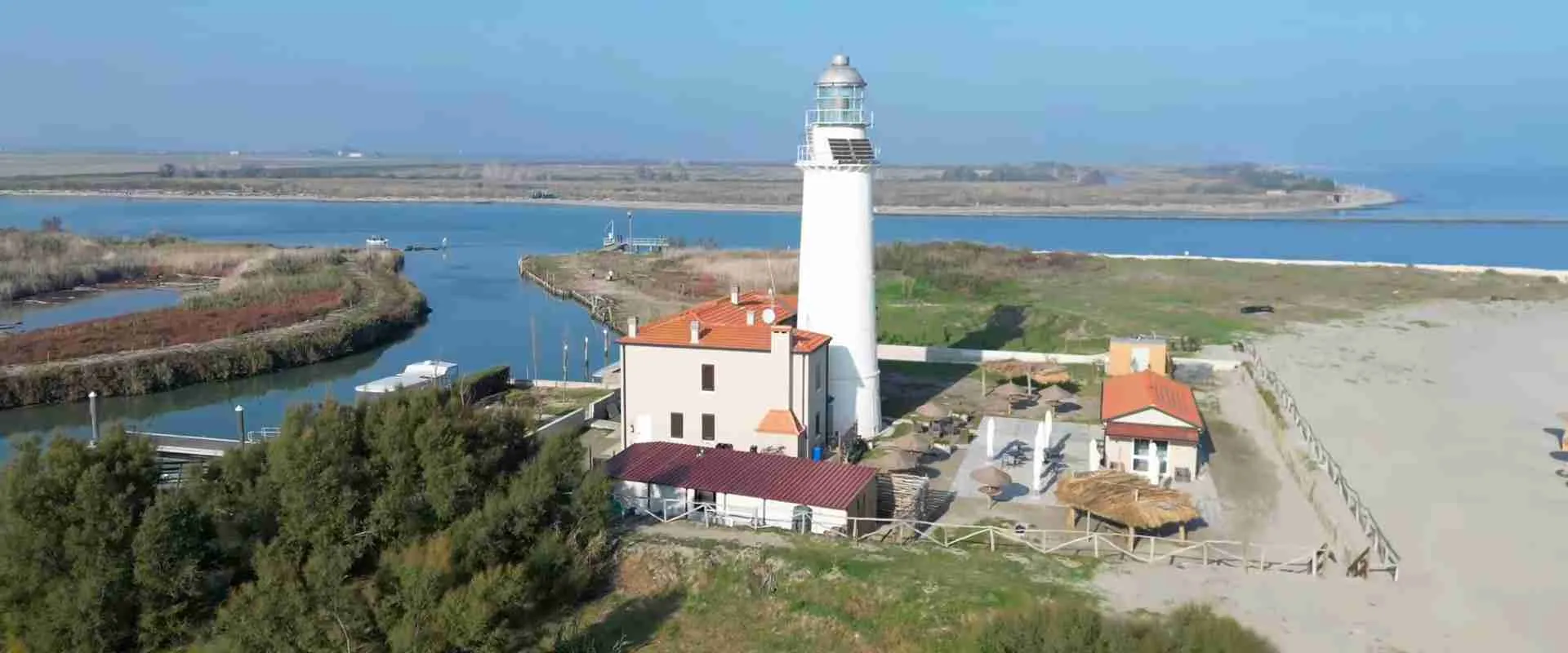
Silt, Salt, and Stone: How Sedimentary Trajectories Sculpted the Po Delta Human Ecosystem
The Po River has spent the last two millennia advancing into the Adriatic Sea at a pace that, measured in human lifetimes, seems imperceptible — yet across centuries it has buried empires, redirected the ambitions of republics, and transformed one of Europe’s most contested coastlines into a mosaic of farmland, lagoon, and wetland. The Po Delta is not simply a geographical feature. It is the cumulative record of a continuous negotiation between three forces: the river’s silt, the sea’s salt, and the stone that humanity has set against both — the cities, the canals, the embankments, and the cultural monuments that mark each attempt to achieve permanence in a landscape defined by flux.
Key Takeaways
- Geologically young, culturally dense: Most of the land in the eastern Po Plain accumulated within the last 4,000 years, with the current delta configuration largely dating to the early modern period following the Taglio di Porto Viro of 1600-1604.
- Cities overtaken by sediment: Ancient coastal settlements including Spina (founded c. 525 BC) and Adria now lie 10-12 kilometres inland, relocated not by their inhabitants but by millennia of delta progradation that pushed the Adriatic coastline progressively eastward.
- Three forces, one ecosystem: Fluvial silt deposition, Adriatic salt intrusion, and human hydraulic engineering have determined every pattern of settlement, economy, and cultural identity in the Po Delta across three thousand years.
- Venice changed everything: The Taglio di Porto Viro (1600-1604), in which the Venetian Republic diverted the Po’s main channel southward through four years of excavation, triggered the most rapid phase of delta growth in recorded history, advancing the coastline at 86 metres per year.
- Exceptional ecological significance: The Po Delta hosts over 360 bird species across habitats ranging from freshwater channels to brackish lagoons to Adriatic sandbars, forming the largest wetland complex in Italy and one of the most important bird migration staging grounds in the Mediterranean basin.
- UNESCO recognition: The delta’s cultural landscape forms part of the UNESCO World Heritage Site “Ferrara, City of the Renaissance, and its Po Delta” (reference 733bis, criteria ii-vi), initially inscribed in 1995 and extended in 1999 to recognise the Po Delta as an outstanding planned cultural landscape under criterion (v).
People Also Ask About the Po Delta Human Ecosystem
What geological forces created and continue to reshape the Po Delta?
The Po Delta is built from sediment transported by the Po River from the Alps and Apennines across Italy’s largest drainage basin. The river deposits silt, clay, and sand where its velocity drops as it meets the Adriatic, forming distributary channels and advancing coastlines. This constructive process operates against two erosive counterforces: Adriatic wave action and storm surges that erode exposed shorelines, and natural compaction and subsidence as newly deposited sediments compress under their own weight. Human interventions — dam construction, gravel extraction from riverbeds, land drainage, and groundwater extraction — have substantially altered the natural sediment budget since the twentieth century. Post-2010 satellite monitoring shows that the northern delta has resumed net progradation, driven by a partial recovery in sediment supply and reduced subsidence rates following restrictions on groundwater extraction.
How did sediment deposition determine the fate of ancient coastal cities in the Po Delta region?
Ancient cities in the Po Delta were established at river mouths that provided natural harbours, access to Adriatic trade routes, and freshwater supplies. As the delta advanced seaward — burying distributary channels with silt, converting open lagoons into marshland, and pushing the coastline progressively eastward — those harbour advantages evaporated. Spina, founded around 525 BC as an Etruscan trading port at the mouth of a major Po distributary, watched its access to the Adriatic narrow and eventually close as the delta built outward around it. The city’s inhabitants reportedly attempted to maintain their connection to the sea by excavating canals through the advancing coastal dunes, but the accumulation of sediment proved faster than any engineering response. By the third century BC the city had been effectively stranded, and by the second century BC it was abandoned. Adria, Ravenna, and the Roman naval base of Classis all underwent comparable transformations across longer timeframes.
What was the Taglio di Porto Viro, and why did the Venetian Republic undertake it?
The Taglio di Porto Viro was a major hydraulic intervention executed between 1600 and 1604 by the Republic of Venice, in which workers excavated a 7-kilometre artificial canal to redirect the Po’s main northern distributary channel southward, away from the Venetian Lagoon. By the late sixteenth century the Po’s Tramontana branch had been advancing northeastward toward the lagoon’s southern inlet, threatening to deliver catastrophic volumes of sediment that would progressively silt up the lagoon and destroy Venice’s harbour advantage. The Venetian Senate authorised the diversion as a defensive measure. The intervention created an entirely new wedge of land in the southern delta within decades, demonstrating the scale at which sediment transport processes could be redirected by human engineering. The modern configuration of the Po Delta — with its dominant southward-trending distributary system — is a direct consequence of this four-year excavation.
How do salt and freshwater dynamics create the Po Delta’s distinctive brackish ecology?
The Po Delta sits at the intersection of two hydrological regimes: the Po River system, which delivers substantial volumes of freshwater and dissolved nutrients, and the northern Adriatic, which delivers salt water through tidal exchange, storm surges, and the phenomenon of acqua alta. Where these two water bodies meet and mix, they create brackish zones of intermediate salinity that support ecosystems found nowhere else in the landscape. Salinity gradients shift seasonally — freshwater dominates in spring and early summer when alpine snowmelt pushes river discharge to maximum, while Adriatic salt water penetrates further inland during late summer low-flow periods. The valli, the extensive brackish lagoon systems at the delta margins, represent a zone of permanent salinity compromise that supports eel populations, migratory waterfowl, endemic aquatic vegetation, and the traditional fishing economies that have persisted around Comacchio for at least a millennium.
Extended multi-day tours – 5+ days
Featured Emilia Romagna Multi-Day Tour Packages
5 days
5 Day Bologna: The Heart of Italy
- ✓ Comprehensive Emilia Romagna tour
- ✓ Expert local guides included
- ✓ All accommodation arranged
- ✓ Transportation provided
4 days
Discovering Bologna
- ✓ Comprehensive Emilia Romagna tour
- ✓ Expert local guides included
- ✓ All accommodation arranged
- ✓ Transportation provided
8 days
Taste of Italy, Emilia-Romagna Culinary Cycling – Classic Self Guided 8day
- ✓ Comprehensive Emilia Romagna tour
- ✓ Expert local guides included
- ✓ All accommodation arranged
- ✓ Transportation provided
4 days
Bologna Gourmet, Good Food and History 4 Days Tour
- ✓ Comprehensive Emilia Romagna tour
- ✓ Expert local guides included
- ✓ All accommodation arranged
- ✓ Transportation provided
Multi-day tour packages powered by TourRadar. Prices and availability subject to change.
Introduction: The Delta as Palimpsest
Few landscapes in Europe carry as many layers of human history as the Po Delta, and few make those layers so literally legible. Archaeology here is not excavation in the conventional sense — the act of digging downward through time — but sometimes the opposite: the slow draining of former lagoons, the peeling back of silt deposited across living cities, the reading of aerial photographs to find the ghostly negative impressions of streets and canals that the river buried centuries ago. The delta is a palimpsest: a surface written on, partially erased, and written on again, in which the original inscriptions still show through.
The three words of this article’s title encode the delta’s fundamental dynamics. Silt is the river’s medium — the fine particles of clay, silt, and very fine sand that the Po carries from its Alpine and Apennine catchment and deposits wherever its velocity drops. Over millennia, these particles have built the entire lower Po Plain, pushing the Adriatic coastline dozens of kilometres seaward from its Bronze Age position. Salt is the sea’s counterclaim — the brackish influence that shapes every ecological zone in the delta’s margins, determining which plants grow, which animals thrive, which fish spawn, and which human economies find sustenance at the freshwater-saltwater interface. Stone is the human response — not merely the geological bedrock that underlies the sedimentary column, but the permanent structures that civilisations have built in their attempts to stabilise, inhabit, and profit from this unstable ground: the Etruscan trading posts, the Roman naval bases, the Byzantine churches, the Este ducal villas, the Venetian flood channels, the twentieth-century land reclamation embankments.
The story of the Po Delta is ultimately the story of stone meeting silt — of human permanence confronting geological impermanence — and of the cultural ecosystem that emerged from that encounter. It is a story that extends from the Bronze Age settlements of the Polesine through the height of Etruscan commerce on the ancient Adriatic, through the Byzantine political geography of late antiquity, through the Renaissance hydraulic engineering of the Este court, through the geopolitical ambitions of the Venetian Republic, and into the twenty-first-century struggle to maintain viable wetland ecosystems and protect cultural heritage from accelerating subsidence and sea-level rise.
The Architecture of Accumulation: Po Delta Geology and Formation
The Po Delta occupies the apex of Italy’s largest alluvial plain, itself one of the largest depositional basins in the Mediterranean region. The entire Po Valley — that vast flat expanse between the Alps to the north, the Apennines to the south, and the Adriatic to the east — is a sedimentary construct. It has been infilling continuously since the early Quaternary period, as rivers draining the surrounding mountain systems transported immense volumes of detritus into a subsiding marine embayment. By the late Pleistocene the marine influence had retreated, and the plain had become a low-energy fluvial system dominated by the Po and its tributaries.
The delta in its current form, however, is a product primarily of the Holocene — the last 11,700 years since the end of the last glacial maximum. As global sea levels rose following deglaciation, the northern Adriatic transgressed progressively northwestward, flooding the lower Po Plain to depths of several metres and creating a broad coastal lagoon system analogous to the modern Venetian Lagoon but vastly larger in extent. This transgressive phase reached its maximum extent around 5,000 to 6,000 years before the present, when much of the area now occupied by agricultural land between Ferrara and the coast was under shallow marine or brackish lagoonal water.
The transition from transgression to progradation — from a coastline advancing inland to one advancing seaward — occurred as sediment supply from the river system began to outpace the rate of sea-level rise. The Po carries enormous quantities of fine sediment from its Alpine and Apennine catchment, including material eroded from the heavily deforested slopes of the Po Valley. Deforestation and agricultural intensification in the watershed, particularly accelerating from the Roman period onward, dramatically increased the sediment load reaching the delta. As that sediment accumulated at the river mouths, it built distributary bars, converted open lagoons into marshland, and pushed the coastline progressively eastward.
The delta’s current morphology reflects a complex history of distributary channel switching — avulsions in which the river abandons one channel and adopts another — that has occurred repeatedly over the last several thousand years. Each major avulsion event reorganised the landscape around a new focal point, stranding former channels as inactive oxbow-like features, building new lobes of sediment at newly active river mouths, and radically restructuring the ecological and human geographies of the affected zones. The Rotta di Ficarolo in 1152 AD, discussed in detail below, was the most consequential of these events in the historical period, but multiple avulsions are documented in the stratigraphic record for the preceding three millennia.
The total thickness of Holocene sediment in the eastern Po Plain ranges from approximately 15 to 30 metres in the proximal delta areas, thinning gradually toward the western plain. This sediment column is extraordinarily fine-grained — dominated by silt and clay rather than sand or gravel — because by the time the Po’s suspended load reaches the delta it has been transported hundreds of kilometres from its source and the coarser particles have long since settled out. The fine-grained nature of the delta sediments has profound practical consequences: they compact readily under overburden loading, causing natural subsidence even in the absence of groundwater extraction; they are highly susceptible to oxidation when drained for agriculture, causing further volume loss; and they provide poor bearing capacity for heavy structures, complicating construction throughout the delta zone.
Silt: The River’s Gift and the Delta’s Engine
The Po River delivers approximately 10 to 15 million tonnes of suspended sediment to the Adriatic annually in its natural state, though this figure has fluctuated dramatically over historical time in response to changes in land use, dam construction, and climate. This sediment — carried in suspension through the river’s water column, transported along the riverbed as bedload, and delivered in pulses during flood events — is the raw material from which the entire delta has been built.
The mechanics of delta building are straightforward in principle. Where the river meets the sea, its flow velocity drops rapidly as the channel expands and loses confinement. Suspended sediment, which requires a minimum current velocity to remain in suspension, settles out and accumulates. Fine clay particles, which remain in suspension at lower velocities than coarser silt and sand, travel furthest before settling — a fact that explains why the offshore zone of the northern Adriatic to the south and east of the delta mouths carries a distinctive plume of fine-grained sediment visible in satellite imagery. The coarser fractions settle closer to the river mouth, forming mouth bars and delta-front shoals that progressively build the exposed land surface.
The Po’s distributary system — the network of branching channels through which the river distributes its flow and sediment across the delta plain — has been both the engine of delta construction and the primary obstacle to human navigation and settlement. The major active distributary branches today are the Po della Pila (which carries the greatest proportion of the river’s discharge), the Po di Goro, the Po di Gnocca, the Po di Tolle, the Po di Donzella, and the Po di Venezia. Each branch builds its own sub-delta lobe at its mouth, and the relative activity of these branches has shifted over time in response to natural avulsion processes and human engineering interventions.
Silt’s role as “gift” to the delta is apparent in the extraordinary agricultural productivity of the reclaimed delta lands. The alluvial soils of the Po Plain rank among the most fertile in Europe, a fact that has made the region Italy’s primary grain, rice, and sugar beet producing area. The same fine-grained sediments that made ancient ports unnavigable and buried prosperous cities became, once drained, the agricultural foundation of a densely populated and intensively farmed landscape.
The river’s sediment supply, however, is not constant. From the mid-twentieth century onward, dam construction on the Po and its tributaries dramatically reduced the volume of sediment reaching the delta. An estimated 80 to 90 per cent of the sediment that would naturally reach the delta under undisturbed conditions is now intercepted by reservoirs. This reduction in sediment supply, combined with accelerated subsidence from groundwater and methane extraction, caused dramatic shoreline retreat in the Po Delta from the 1950s through the 1970s — a period during which mean shoreline retreat rates reached approximately 9 metres per year in the most affected areas. Post-2010 satellite data indicates that the northern delta has partially recovered, with renewed progradation at active distributary mouths, but the overall sediment deficit remains substantial.
Salt: The Adriatic’s Counterclaim and the Brackish Frontier
The Adriatic Sea does not passively receive the Po’s sediment. It pushes back. The northern Adriatic, with its shallow bathymetry and exposure to the bora and sirocco winds, generates wave energy and storm surge that erode exposed delta shorelines, redistribute deposited sediment along the coast, and drive salt water inland through tidal channels and lagoonal inlets. The result is a dynamic brackish frontier — a zone of mixing and negotiation between freshwater and saltwater that defines the ecological character of the delta margins and has shaped human settlement and economy throughout the historical period.
Salinity in the delta is not a simple gradient from fresh to salt as one moves from river to sea. It is a complex, seasonally variable, spatially heterogeneous mosaic driven by the interaction of river discharge, tidal amplitude, wind-driven surge, and the geomorphology of individual lagoon basins. The northern Adriatic has a tidal range of approximately 50-80 centimetres — relatively modest by Atlantic standards but sufficient to drive daily pulses of salt water into the lagoonal systems at the delta margins. During periods of low river discharge in late summer and autumn, salt water penetrates substantially further inland, altering the salinity of the valli and the sediment chemistry of the delta plain.
The ecological consequences of this salt-freshwater interface are profound. Salinity acts as the primary sorting mechanism for aquatic species in the delta, determining which organisms can survive in each zone and creating a succession of distinct habitat types from the freshwater river channels through intermediate brackish lagoons to fully marine conditions at the Adriatic shoreline. The valli da pesca — the managed brackish lagoon systems that have been central to delta economies for a millennium — exploit this salinity gradient precisely: they are maintained at an intermediate salinity level that provides ideal conditions for the eel (Anguilla anguilla) and other euryhaline species that tolerate wide variations in salt content.
Salt also shapes the terrestrial vegetation of the delta margins. The transition from freshwater-influenced marsh to brackish lagoon to saline tidal flat supports a characteristic sequence of plant communities: freshwater reed beds (dominated by Phragmites australis) giving way to brackish-tolerant sedge communities, then to halophytic vegetation including glasswort (Salicornia) and sea purslane (Atriplex portulacoides) on the highest parts of tidal mudflats. These halophyte communities are themselves sediment traps — their roots and stems slow water movement and promote fine sediment deposition — making them active participants in delta construction rather than merely passive inhabitants of already-built surfaces.
The salt pans of Comacchio represent one of the earliest human exploitations of the salt-freshwater dynamic. Salt production in the delta zone dates to at least the early medieval period and became a significant driver of regional trade and political conflict. The medieval salt wars between Comacchio and Venice, which culminated in the Venetian sacking and burning of Comacchio in 883 and 932, were fundamentally conflicts over the economic value of the brackish frontier — over the right to harvest the Adriatic’s mineral gift from the evaporating lagoon margins.
Stone: Ancient Cities Built on Unstable Ground
The cities of the Po Delta are built on sediment, and sediment has always claimed them back. The geological instability that makes the delta one of Europe’s most dynamic landscapes has been, for human civilisations across three millennia, the fundamental challenge of existence in this territory. Every city that established itself at the delta’s margin was making an implicit wager against the river’s next course change, the sea’s next salt incursion, the slow subsidence of the alluvial ground beneath its foundations.
Stone — the material of permanence — carries particular symbolic weight in this context. In a landscape composed entirely of soft alluvial sediment, the act of building in stone or brick was an assertion of durability against the unstable substrate. The survival of Roman and Byzantine masonry in Ravenna, the persistence of Este brickwork in the delta countryside, the buried Etruscan stone anchors and ceramic assemblages of Spina’s necropolis — all represent human attempts to leave a legible mark on a surface that the river is perpetually trying to erase. The success of these attempts has been partial at best: cities that were coastal emporia are now inland towns, naval bases are farmland, port harbours have become lagoons.
The “stone” of the delta ecosystem is also the built infrastructure of hydraulic engineering: the argini (levees) and flood embankments that constrain the Po’s channels, the scolmatori (drainage channels) of the bonifica system, the lock gates and weirs that regulate the salinity of the valli, the canals dug over four years by Venetian engineers to redirect an entire river. These are not decorative stonework but the functional skeleton of a managed landscape — the hard infrastructure that makes the delta’s extraordinary agricultural productivity possible and that keeps millions of people safe from a river that would otherwise flood the plain every decade.
Stone also appears in the delta as absence — as the absence of the geological substrate that underlies the entire sedimentary column. The Po Plain sits on a pre-Quaternary limestone and marl bedrock that lies anywhere from 30 to several hundred metres below the alluvial surface. The archaeological and structural challenges of building in the delta are rooted in this bedrock’s inaccessibility: foundations cannot reach solid rock, wells must penetrate deep into confined aquifers, and the entire built environment sits on material that is actively compacting, oxidising, and sinking.
Spina: The Lost Etruscan Emporium of the Ancient Adriatic
Spina was one of the greatest commercial cities of the ancient Mediterranean world, and the delta buried it so completely that its very existence was doubted by scholars until the twentieth century. Founded around 525 BC at the mouth of a major Po distributary on the Adriatic coast of what is now the province of Ferrara, Spina served for approximately three centuries as the northern terminus of the Adriatic trade route — the port through which the luxury goods of Athens, the manufactured products of the Greek world, and the amber of the Baltic reached Etruscan civilisation in the Po Valley and beyond.
The city’s layout, revealed in extraordinary detail by aerial photography during drainage works in the 1920s through 1960s, was that of a planned settlement on a marshy site: an irregular perimeter protected by earthen ramparts, streets on a square grid plan oriented northwest to southeast, and timber-framed houses built on the soft delta sediments. The dark lines of ancient canals appeared in the aerial photographs as ghost impressions in the soil — vegetative traces left by the richer organic matter that filled former watercourses when they were abandoned. The overall picture was of a city that functioned as a kind of ancient Venice: a maritime emporium built on and around water, navigable by small vessels through a dense network of channels connecting the settlement to the open sea.
The necropolis excavated at Valle Trebba and Valle Pega has yielded over 4,000 graves dated from the late sixth to the early third century BC, containing some of the finest Greek ceramic imports found anywhere outside Greece itself — Attic red-figure pottery of the highest quality, bronzework, gold and silver jewellery, amber beads from the Baltic, and glass paste ornaments from the eastern Mediterranean. These finds, now housed primarily in the National Archaeological Museum in Ferrara, constitute the most comprehensive documentation of the Greek-Etruscan commercial relationship in northern Italy, and they reflect the extraordinary wealth that flowed through Spina’s harbour during its peak period.
The site of Spina is today approximately 12 kilometres from the Adriatic coast near Comacchio — a measure of the delta’s advance since the city’s foundation. The necropolis, which in antiquity stood on sandy coastal dunes immediately behind the shoreline, now lies in what was until the mid-twentieth century a shallow lagoon. The city itself, identified in 1960 during drainage works in the Mezzano valley, sat precisely along a middle distributary of the ancient Po delta known in medieval documents as the Padus Vetus. When this distributary silted up and was abandoned, Spina lost its maritime access. The Etruscans are recorded as having attempted to maintain connection with the sea by excavating canals through the advancing coastal dunes — an early instance of the hydraulic engineering response to delta dynamics that would characterise the entire subsequent history of the region.
After being sacked by the Gauls around 400 BC and losing its harbour access to delta siltation, Spina contracted from a major commercial emporium to a minor agricultural settlement, and by the second century BC the urban core had been effectively abandoned. The Roman period left only scattered rural villas and drainage works on the site. The medieval name Santa Maria in Padovetere, applied to an early Christian church built near the site of the vanished city, attests to the demographic tenacity of the location even after the city’s commercial function had ceased — people continued to live near the old channels and dunes long after the city itself was gone.
Adria and the Sea That Bears Its Name
Adria stands as perhaps the most striking single demonstration of the Po Delta’s capacity to reshape geographies: a city that gave its name to an entire sea is now twenty-five kilometres from that sea’s shoreline, separated from the Adriatic by land that the river built after the city’s foundation. The Etruscan settlement at Adria developed from the twelfth to ninth centuries BC as stilt-house communities in the wetlands, when the site still lay close to the coast and the main Po distributary — the ancient Adria channel — passed immediately adjacent. By the classical foundations period, dated to 530-520 BC, the port was well established as a coastal trading station and, along with Spina to its south, one of the two principal Etruscan depots for commerce with the Felsina (Bologna) hinterland.
The name “Adriatic Sea” derives from the ancient city of Adria, through the Greek form Adrias. The etymology of “Adria” itself remains contested: the most widely cited derivation connects it to the Illyrian word adur, meaning “water” or “sea,” while an Etruscan origin relating to the concept of sunrise or east has also been proposed. Whatever its linguistic origin, the toponym passed from the city to the surrounding waters — reflecting the city’s role, in the Greek and early Roman geographical imagination, as the northernmost significant port of the sea that bore its name.
Like Spina, Adria was gradually overtaken by delta progradation. The Po distributary that had originally served as its harbour access silted up and was abandoned in the first century BC, severing the city’s direct connection to the sea. Unlike Spina, however, Adria did not disappear. It survived the loss of its maritime function by adapting to an inland role — as a Roman municipium, then as a Byzantine centre, then as a medieval and early modern town connected to the sea only by navigable channels cut through the advancing delta. The remains of the Etruscan city lie three to four metres below the modern street level, testament to the depth of alluvial accumulation above the original settlement surface.
The modern city of Adria retains its National Archaeological Museum, whose collections document the extraordinary cultural and commercial vitality of the pre-Roman settlement. The finds include imported Attic ceramics rivalling those of Spina, indigenous Venetic and Etruscan bronzework, and stratigraphic evidence of the successive sedimentary layers that document the city’s gradual disconnection from the coast it once commanded.
Ravenna: Coastal Capital, Byzantine Mosaic, and the Retreating Sea
Ravenna’s career as one of the most important cities in late antique and early medieval Europe depended entirely on its position within the Po Delta’s lagoonal system — and that career ended when the delta’s advance transformed its lagoons into dry land. The city rose to imperial prominence precisely because it occupied a position that was simultaneously defensible and connected: surrounded by marshes and lagoons that made overland attack extremely difficult, yet accessible by sea through the Adriatic and by river through the Po system. When Augustus established the military harbour of Classis approximately 3-4 kilometres southeast of the city around 27 BC, he was exploiting a coastal geography that already made Ravenna one of the few viable port sites on the northwestern Adriatic coast.
At the height of Roman Classis, the harbour accommodated up to 250 warships and housed approximately 10,000 marines and their families. The mosaics of the Basilica of Sant’Apollinare Nuovo, created in the sixth century AD, depict the Civita Classis as a thriving urban port, its towers and walls rising directly from the waterfront. This depiction was already somewhat idealised when it was created: the silting of the communication canals between the harbour and the sea was accelerating from the third century AD onward, and by the eighth century the harbour had lost its commercial and military function entirely. Today the site of Classis lies several kilometres inland, and the modern port of Ravenna connects to the sea through a 12-kilometre canal — an engineering solution that exactly parallels the artificial channels that the Etruscans of Spina cut through the coastal dunes to maintain their sea access as the delta advanced around them.
The cultural legacy of Ravenna’s delta position is written in its extraordinary concentration of late antique and early Byzantine monuments. As capital of the Western Roman Empire (from 402 AD under Emperor Honorius), then as capital of the Ostrogothic kingdom of Theodoric, then as the capital of the Byzantine Exarchate of Ravenna, the city accumulated a succession of churches and mausolea whose mosaic programmes represent the most complete surviving documentation of early Christian and Byzantine art in the western Mediterranean. Eight of these monuments together constitute the UNESCO World Heritage Site “Early Christian Monuments of Ravenna” (inscribed 1996). Their survival is in part a consequence of the delta’s dynamics: the same waterlogging that threatened Ravenna’s physical foundations also inhibited the destructive building activity that replaced comparable monuments elsewhere, preserving the city’s late antique urban fabric in exceptional completeness.
Ravenna is now approximately nine to ten kilometres from the Adriatic coast, connected to the sea by the Candiano Canal. The distance between the city and its former shoreline represents, in physical terms, approximately fifteen centuries of delta progradation — sediment deposited from the Po and from the Apennine rivers Reno and Lamone that together built the coastal plain between the ancient lagoonal city and the modern Adriatic. The coastal pine forests of San Vitale and Classe, planted from Roman times onward on the stabilised coastal dunes, mark the former shoreline zone and constitute some of the finest surviving examples of Italian coastal pineta.
The Rotta di Ficarolo: A Medieval Course Change and Its Consequences
The Rotta di Ficarolo of 1152 was the most consequential natural event in the medieval history of the Po Delta, a spontaneous course change that redirected the entire discharge of Italy’s largest river and set in motion a chain of geopolitical, economic, and geomorphological consequences that shaped the region for the following five centuries. The “rotta” — literally a breach or breakage — occurred upstream of the delta at the village of Ficarolo, where the Po’s main channel breached its natural levee and found a new course heading northeastward toward the Adriatic rather than the more southerly path it had previously followed.
The consequences were immediate and profound. The former main channel — the Padus Vetus, which had previously carried the bulk of the river’s flow past Ferrara and through the territory that would become the Este duchies — lost its discharge abruptly, silting up over the following decades and centuries into the marsh and farmland that characterises this part of the Po Plain today. The new Tramontana channel developed an active delta that advanced toward the Adriatic at approximately 25 metres per year, building new land in areas previously occupied by lagoon and open water and simultaneously threatening the harbours of cities and settlements that depended on the old channel system.
For the Este signoria of Ferrara, the Rotta di Ficarolo was an existential challenge and an extraordinary opportunity. The dramatic reduction in Po flow past the city threatened its agricultural and commercial hinterland — the network of waterways that connected Ferrara to the Po Valley economy depended on adequate river flow. But the new deltaic territories that the Tramontana branch was building provided a vast and potentially productive blank canvas for the Este programme of landscape engineering and colonisation that would define the dynasty’s most ambitious phase of territorial expansion.
The Rotta di Ficarolo also made Venice nervous. The Tramontana branch was advancing directly toward the southern approaches to the Venetian Lagoon, and by the late sixteenth century its delta had drawn close enough to the lagoon’s southern inlets to generate serious concern about catastrophic silting. This concern drove the Venetian Senate’s decision, made in the 1590s, to undertake the most ambitious hydraulic engineering project of the early modern period in the Italian peninsula.
The Este Dynasty: Engineering an Ideal Landscape
The Este lords of Ferrara approached the Po Delta not as a hostile or difficult environment but as a material for design — a vast territory of water, marsh, and alluvial sediment that could, with sufficient investment in hydraulic engineering, be transformed into a productive and aesthetically coherent landscape expression of ducal power. The dynasty’s engagement with the delta intensified from the late fourteenth century onward, and by the mid-fifteenth century it had become the organising principle of the Este court’s most ambitious cultural project: the creation of an “ideal” territory that would embody Renaissance concepts of order, beauty, and human mastery over nature.
The instrument of this ambition was the network of delizie — ducal pleasure villas and estates distributed across the delta countryside and connected to Ferrara by a dense system of waterways. The word “delizie,” meaning “delights” or “pleasures,” captures the aesthetic programme: these were not merely agricultural estates or defensive outposts but expressions of Renaissance humanist ideals about the relationship between architecture, landscape, and governance. At the height of the Este programme, approximately 52 delizie are documented in the delta territory, ranging from modest hunting lodges to substantial palace complexes surrounded by formal gardens, orchards, and managed hunting grounds. Most have been lost to subsequent centuries of agricultural transformation, but their legacy persists in the extraordinarily rational landscape of the lower Ferrara plain — the straight drainage canals, the regularised field boundaries, the grid-like geometry of a territory that was systematically redesigned by ducal engineers.
The hydraulic infrastructure that underlay the delizie programme was both practically necessary and symbolically charged. The Este engineers designed systems of canals, locks, and weirs that served simultaneously as transportation networks, flood control works, and demonstrations of the dynasty’s technical sophistication. The bonifica — the systematic drainage of wetlands to create new agricultural land — began in earnest under the Este, converting tens of thousands of hectares of delta marsh into productive farmland and in the process fundamentally altering the hydrological and ecological character of the lower Po Plain.
The UNESCO inscription of the “Ferrara, City of the Renaissance, and its Po Delta” under criterion (iii) specifically recognises this achievement: the Este ducal residences in the Po Delta “illustrate the influence of Renaissance culture on the natural landscape in an exceptional manner.” Under criterion (v), the Po Delta itself is recognised as “an outstanding planned cultural landscape that retains its original form to a remarkable extent.” The modern landscape visitor who sees the regularised canals and straight field boundaries of the Ferrara plain is looking at the physical legacy of the Este programme — a Renaissance concept of ideal landscape that has persisted in its essentials for five centuries.
Biagio Rossetti, the Este court architect responsible for the Addizione Erculea of Ferrara — the Renaissance urban extension that UNESCO has called the birth of modern town planning — applied to the city the same principles of geometric order and rational planning that the Este engineers were simultaneously applying to the delta countryside. The city and its rural hinterland were designed as a single integrated concept: an expression in stone, brick, canal, and managed land of the humanist conviction that the ideal society inhabits an ideal space.
The Taglio di Porto Viro: Venice’s Decisive Intervention
The Taglio di Porto Viro remains, four centuries after its completion, one of the most consequential single acts of landscape engineering in European history. Between May 1600 and September 1604, workers employed by the Republic of Venice excavated a 7-kilometre artificial canal through the delta near the settlement of Porto Viro, diverting the Po’s main northern distributary channel southward and permanently redirecting the trajectory of the delta’s growth away from the Venetian Lagoon. The work took four years and involved an organisation of labour and logistics that represented the full mobilisation of Venetian state resources.
The geomorphological consequences were spectacular. After the diversion, the redirected channel advanced in a southeasterly direction at a measured rate of 86 metres per year — faster than any previous phase of delta progradation in the historical record. Within decades, a new triangular wedge of land had formed in the southern delta, building outward into the Adriatic at a pace visible within a single human lifetime. The new lands, composed primarily of brackish marsh and reed bed, were rapidly surveyed, sold, and purchased by Venetian noble families who invested in drainage and agricultural development. The toponym Taglio di Po — the “cutting of the Po” — was applied to the settlement that grew up at the site of the original excavation and persists to the present day as a municipality of approximately 7,000 inhabitants.
The Taglio’s significance extends beyond its immediate geomorphological effect. It represents a conceptual threshold in the history of the delta: the moment at which the Po Delta definitively transitioned from a natural system subject to human modification to an anthropogenic system managed and maintained by human engineering. After 1604, the configuration of the delta was no longer primarily determined by natural avulsion dynamics but by the ongoing interventions of the institutions — Venetian noble families, the Papal State, and their successors — that owned and managed the delta territory. The delta became, in the phrase used in the UNESCO criterion (v) recognition, a “planned cultural landscape.”
The Venetian intervention also, paradoxically, created the conditions for the ecological richness that now defines the Po Delta as a protected area. The southern delta built by the Taglio’s diversion accumulated sediment faster than it could be drained and cultivated, creating an extensive zone of marsh, lagoon, and brackish wetland that persisted through the subsequent centuries of land reclamation pressure. Much of what is now protected as the Po Delta Regional Park occupies territory that exists because of the 1600-1604 diversion — land built by the redirected river that was too wet, too remote, or too ecologically sensitive to be fully converted to agriculture.
The Bonifica: Reclaiming the Delta Plain from the Water
The bonifica — the systematic drainage of wetland to create agricultural land — is the great human project of the Po Delta, undertaken in episodes from the Este period through the early twentieth century and transforming the landscape more completely than any other intervention except the Taglio di Porto Viro itself. The word means literally “amelioration” or “improvement,” a term that encodes the ideological conviction that wetland is waste and that its conversion to farmland represents an unambiguous advance for human welfare. This conviction, dominant from the Renaissance through the fascist period, has been substantially revised by conservation biology and ecosystem services science, but its physical legacy persists in every straight drainage canal and regularised field boundary in the Po Plain.
The Este programme of drainage, described above, established the basic infrastructure of the bonifica system in the Ferrara lowlands during the fifteenth and sixteenth centuries. It was continued by the Papal State after the Este dynastic line failed and Ferrara passed to papal control in 1598, and again by the Venetian noble families in the territories they controlled in the northern delta. But the most intensive phase of drainage occurred in the late nineteenth and early twentieth centuries, when the development of electrically powered centrifugal pumps made it possible to drain areas that lay below sea level — areas in which gravitational drainage was physically impossible and in which any accumulation of water had to be mechanically lifted into channels elevated above the surrounding terrain.
The low-lying delta plain is today maintained above water by a system of approximately 900 pumping stations that continuously extract drainage water from fields that lie in many cases 1-3 metres below sea level. This situation is the direct consequence of two interacting processes: the original land surface, when drained, subsided through oxidation of organic matter and compaction of clay; and the ongoing subsidence of the delta sediments means that even newly reclaimed land progressively sinks relative to sea level. Without continuous pumping, the reclaimed lands of the eastern Po Plain would revert to wetland within years to decades.
The bonifica obliterated the vast majority of the wetland habitats that had characterised the lower Po Plain for millennia. The Valli di Comacchio, which once covered approximately 70,000 to 100,000 hectares of the Ferrara lowlands, have been reduced by successive drainage campaigns to approximately 10,000 hectares of surviving lagoon. The marshes that sheltered Ravenna from Roman-era invaders have been converted to cereal fields. The reed beds that lined the ancient delta distributaries have been replaced by drainage canals. The ecological and cultural losses implicit in this transformation are incalculable; the agricultural productivity gained has supported millions of people across multiple centuries.
The Valli da Pesca: A Human Ecology of Brackish Water
The valli da pesca — the managed brackish fishing lagoons of the Po Delta — represent one of the most sophisticated examples of traditional ecological knowledge and sustainable resource management in the Mediterranean basin, and one of the few elements of the pre-bonifica delta landscape to survive the twentieth century’s drainage imperative. Concentrated around Comacchio and the surviving fragments of the Valli di Comacchio, these lagoons have been managed as productive fishing environments for at least one thousand years, and their management practices embody a detailed understanding of estuarine ecology, eel behaviour, tidal dynamics, and brackish water chemistry accumulated across generations of professional fishermen.
The eel (Anguilla anguilla) is the ecological and economic keystone of the valli system. Eels are catadromous fish — they spend their adult lives in freshwater or brackish environments but migrate to the open ocean to spawn, making a single one-way journey from their feeding grounds in the delta lagoons to the Sargasso Sea in the western Atlantic, where they breed and die. This migration pattern, in which mature eels leave the lagoons in autumn to begin their oceanic journey, provided the biological basis for the lavoriero — a system of funnel-shaped traps and weirs positioned at the lagoonal outlets to intercept outward-migrating eels. The design exploits the eels’ directional movement: fish attempting to reach the sea are guided by the weir system into progressively confined spaces from which escape is impossible. Traditional lavorieri were constructed from woven reeds and wooden stakes; contemporary versions use steel mesh and concrete, but the hydraulic principles are identical.
Comacchio’s eel fishing tradition generated a distinctive food culture built around the processing and preservation of the catch. The Manifattura dei Marinati — a purpose-built eel processing factory established in the eighteenth century and now preserved as an ecomuseum — documents the industrial-scale marinating and canning operations that preserved the eel catch for export across the Italian peninsula and beyond. Marinated eel in vinegar and herbs (anguilla marinata) remains the signature dish of Comacchio’s culinary heritage and holds Slow Food Garrison status as a threatened traditional product. The factory’s restoration and reopening as a working museum in 2004 was one of the first major heritage tourism investments in the Po Delta, anticipating the broader development of cultural and ecological tourism that now serves as the delta’s primary growth economy.
The salt pans of the Ferrara coast, visible from the dunes behind Lido degli Estensi and now incorporated into the Po Delta Regional Park as a strictly protected reserve, constitute a parallel human exploitation of the salt-freshwater interface. Salt production in the delta zone dates to at least the Byzantine period — Comacchio’s medieval power was built substantially on its salt trade — and the evaporation ponds that survive today continue to function, producing salt as a secondary product and maintaining habitats critical for the nesting of flamingos, avocets, and other wading birds.
The Po Delta Regional Park and Its UNESCO Recognition
The Po Delta Regional Park (Parco Regionale del Delta del Po) was established in 1988 to protect the surviving wetland habitats of the lower Po Plain against further drainage and development pressure. It covers 20,536 hectares across two Italian regions — Emilia-Romagna and Veneto — and includes within its boundaries the Valli di Comacchio, the coastal lagoon systems of the Sacca di Goro and Sacca degli Scardovari, the beach ridge and dune systems of the Adriatic shoreline, the pine forests of San Vitale and Mesola, and sections of the active Po distributary channels and their margins.
The park’s establishment recognised the international significance of the surviving wetlands as habitat for migratory and breeding birds. The Po Delta hosts over 360 bird species — a figure representing approximately 60 per cent of all bird species recorded in Italy — and functions as one of the most important wetland complexes in the Mediterranean basin for both breeding colonial waterbirds and migratory shorebirds using the East Atlantic Flyway. Notable breeding species include purple heron (Ardea purpurea), spoonbill (Platalea leucorodia), glossy ibis (Plegadis falcinellus), little egret (Egretta garzetta), several tern species, and breeding colonies of Mediterranean gull. Winter brings large numbers of diving ducks, waders, and other waterbirds to the lagoon systems.
The park territory is additionally protected as a Ramsar Wetland of International Importance, a European Union Special Protection Area (SPA) and Site of Community Importance (SCI) under the Birds and Habitats Directives, and a UNESCO Man and Biosphere (MAB) Reserve designated in 2015. The MAB designation explicitly recognises the equilibrium between natural heritage values and the traditional human activities — fishing, salt production, limited agriculture — that have maintained the ecological character of the surviving wetlands over centuries.
The UNESCO World Heritage inscription of “Ferrara, City of the Renaissance, and its Po Delta” encompasses the delta cultural landscape as an integral part of the Este Renaissance programme. The 1999 extension to include the Po Delta territory (reference number 733bis) added criteria (iii) and (v) to the existing criteria (ii), (iv), and (vi) under which Ferrara’s urban historic centre had been inscribed in 1995. Criterion (v) — recognising the Po Delta as “an outstanding planned cultural landscape that retains its original form to a remarkable extent” — is the most significant from a landscape perspective, encoding UNESCO’s judgement that the Renaissance-era drainage and settlement programme created a coherent cultural landscape whose essential geometry and character remain legible today despite five centuries of subsequent modification.
The Contemporary Crisis: Subsidence, Dams, and Sea-Level Rise
The Po Delta faces a convergence of anthropogenic and climatic stresses in the twenty-first century that threatens both its surviving natural heritage and the agricultural systems that sustain its human population. Three processes interact in particularly damaging ways: land subsidence, reduced sediment supply, and sea-level rise. Each individually would represent a significant management challenge; together they constitute what geomorphologists describe as a “relative sea-level rise” problem — a situation in which the effective rise of the sea relative to the land results not only from global sea-level rise but from the land simultaneously sinking.
Subsidence in the Po Delta has two components. Natural compaction of Holocene sediments — an intrinsic property of newly deposited fine-grained material — proceeds at a rate of a few millimetres per year in the proximal delta, increasing toward the east where fine-grained inter-distributary sediments predominate. This natural rate is modest and broadly comparable to the sediment supply rate under pre-anthropogenic conditions, meaning that the delta was broadly in equilibrium — neither gaining nor losing elevation — before human intervention. The anthropogenic component, driven primarily by groundwater and methane extraction from shallow subsurface aquifers, has been catastrophic in local areas. During the peak of methane extraction in the Ravenna area during the 1950s and 1960s, subsidence rates reached 10 centimetres per year in the most affected zones — rates approximately 20 to 50 times higher than natural background levels. The legacy of this extraction persists: large areas of the eastern delta plain are now 1-3 metres below sea level and will remain so permanently, maintained above water only by continuous pumping.
The reduction in sediment supply from upstream dam construction, discussed earlier in the context of its impact on delta morphology, has removed the natural mechanism by which delta surfaces were formerly maintained at or above sea level. In a pre-dam river system, flooding events deposited thin layers of sediment across the delta plain that partially compensated for ongoing subsidence; in the dammed system, those compensatory deposits no longer occur. The result is an accelerating vertical deficit: the delta surface sinks while the sea level rises, and nothing replenishes what is lost.
Climate projections for the northern Adriatic indicate sea-level rise of 0.3 to 0.8 metres by 2100 under intermediate emissions scenarios, with higher-end scenarios approaching 1 metre or more. Against a baseline of delta surfaces already 1-3 metres below current sea level in the most affected areas, even the lower end of projected sea-level rise represents a substantial intensification of existing flood risk. The barrier island and beach ridge systems that protect the delta’s Adriatic margin from storm surge are themselves subject to erosion under reduced sediment supply, further reducing the landscape’s capacity to buffer against extreme events.
The post-2010 recovery of progradation in the northern delta — documented by satellite monitoring and attributed to reduced subsidence rates and partial sediment supply recovery — offers a partial counterpoint to this trajectory of deterioration. The delta is demonstrating a capacity for resilience that distinguishes it from many large delta systems globally, where progradation has ceased entirely. But this recovery is locally restricted, affecting primarily the most active distributary mouths in the Veneto sector of the delta while the Emilia-Romagna sector remains in a state of chronic sediment deficit and ongoing subsidence.
The Delta as Living Laboratory: Biodiversity and Ecological Significance
The Po Delta’s ecological value is inseparable from its sedimentary history. The heterogeneous mosaic of habitats that makes the delta one of Italy’s most important biodiversity hotspots — freshwater channels, brackish lagoons, tidal mudflats, coastal dunes, beach ridges, saltmarsh, reed beds, and riparian woodland — is a direct product of the complex sedimentary and hydrological processes that have operated here across millennia. Each habitat type occupies a distinct position along the gradients of salinity, water depth, sediment grain size, and inundation frequency that the interplay of river and sea creates across the delta surface.
The freshwater habitats of the active distributary channels support fish assemblages dominated by cyprinids, perch, and migratory species including the European eel, sea lamprey (Petromyzon marinus), and twaite shad (Alosa fallax). The transitional zone between river and lagoon supports the greatest fish species diversity, as euryhaline species that tolerate a wide range of salinities concentrate at the salinity boundary to exploit the high productivity associated with nutrient mixing. The brackish lagoons of the Valli di Comacchio and Sacca di Goro are among the most productive aquatic environments in Italy per unit area, a consequence of the continuous nutrient input from river water mixing with the concentrated mineral content of marine water.
The coastal dune systems of the delta’s Adriatic margin, built from wind-reworked river sand deposited at the distributary mouths, support distinctive plant communities including sea holly (Eryngium maritimum), sea rocket (Cakile maritima), marram grass (Ammophila arenaria), and the endemic Po Delta sand lily (Pancratium maritimum). Behind the active foredunes, stabilised fossil dune ridges support characteristic Mediterranean scrub vegetation of sea buckthorn (Hippophae rhamnoides) and sea purslane. The coastal pine forests planted on the stabilised dunes from Roman times onward — the Pineta di San Vitale north of Ravenna and the Pineta di Classe to the south — constitute some of the most ancient planted forests in Italy and provide nesting habitat for raptors, woodpeckers, and numerous passerine species.
The Bosco della Mesola, a fragment of ancient lowland forest at the northeastern corner of the delta protected as a state nature reserve, harbours the last surviving population of the Italian red deer (Cervus elaphus italicus), a subspecies extirpated from the rest of Italy by overhunting and habitat loss. The forest also supports populations of roe deer, wild boar, and the introduced fallow deer, together with exceptional reptile and amphibian diversity exploiting the forest’s network of internal channels and seasonal pools.
The delta’s importance as a bird migration staging and wintering ground is well documented. Over 360 species have been recorded in the park territory, spanning the full range from breeding colonial waterbirds through migratory Arctic shorebirds to wintering diving ducks from the northern boreal zone. The concentration of suitable habitats at the junction of the East Atlantic and Central European flyways makes the delta a critical node in the continental migration system — a refuelling stop where birds from breeding grounds in northern and eastern Europe rest and feed before continuing south to African wintering grounds. The loss of any significant portion of the delta’s wetland area would have consequences for bird populations across a geographic range extending thousands of kilometres beyond the delta itself.
Frequently Asked Questions
How old is the Po Delta as a geographical feature?
The Po River has been depositing sediment into the northern Adriatic throughout the Holocene, the 11,700 years since the last glacial maximum. However, the current delta configuration — with the coastline in roughly its present position — is substantially younger. The major westward transgression of the Adriatic reached its maximum around 5,000-6,000 years ago, after which the delta began prograding seaward as sediment supply outpaced sea-level rise. The present shape of the delta is largely a product of the last 1,500 years, with the dominant southward-trending distributary system dating specifically to the 1600-1604 Venetian diversion of Porto Viro. In the most literal sense, significant portions of the delta surface that are now agricultural land did not exist as land until the seventeenth century AD.
What is the connection between the Po Delta and the Venetian Lagoon?
The Po Delta and the Venetian Lagoon are adjacent features of the same depositional coast, and their relationship has been one of mutual influence and periodic conflict for over a thousand years. The lagoon, which formed through processes broadly similar to the delta’s lagoonal margins, has always been vulnerable to silting by the rivers draining the Veneto Plain. The Venetian Republic spent centuries managing this vulnerability through hydraulic engineering, systematically diverting rivers away from lagoon inlets to prevent sediment from reaching the basin. The Po’s Tramontana distributary, advancing northeastward after the Rotta di Ficarolo in 1152, threatened precisely this vulnerability by the late sixteenth century — hence the Taglio di Porto Viro. Venice’s determination to protect its lagoon from the Po’s sediment was thus the direct cause of the modern Po Delta’s configuration, making the two landscape features inseparably linked in their current forms.
What is the Parco Regionale del Delta del Po and what habitats does it protect?
The Parco Regionale del Delta del Po, established in 1988, is Italy’s most important protected wetland complex, covering 20,536 hectares across the Emilia-Romagna and Veneto regions. It protects the Valli di Comacchio (approximately 10,000 hectares of brackish lagoon), the coastal lagoon systems of the Sacca di Goro and Sacca degli Scardovari, active Po distributary channels and their riparian margins, coastal dune and beach ridge systems, the ancient pine forests of San Vitale and Classe, salt pans near Comacchio, and the Bosco della Mesola old-growth forest. The park holds Ramsar Convention designation as a wetland of international importance, European Union SPA and SCI status, and since 2015 has been designated as a UNESCO Man and Biosphere (MAB) Reserve. Its 360+ bird species represent approximately 60 per cent of Italy’s national bird checklist.
What happened to the ancient port city of Spina?
Spina was an Etruscan trading port founded around 525 BC at the mouth of a Po distributary on the Adriatic coast. At its peak in the fifth century BC it was one of the most commercially significant cities in the pre-Roman Mediterranean, serving as the northern terminus of the Adriatic trade route and handling enormous volumes of luxury goods between Greece and the Etruscan civilisations of the Po Valley. The city was built on a marshy delta site and depended on open access to the Adriatic through its harbour channels. As delta progradation pushed the coastline seaward, those channels silted up and the city’s maritime access was progressively severed. After being sacked by the Gauls around 400 BC, Spina never recovered its commercial significance and was effectively abandoned by the second century BC. The site now lies approximately 12 kilometres inland near Comacchio, buried under metres of alluvial sediment. Its layout was revealed by aerial photography during twentieth-century drainage works, and its necropolis — containing over 4,000 graves — now provides the primary archaeological evidence of the Greek-Etruscan commercial relationship in northern Italy.
How did the Taglio di Porto Viro change the Po Delta permanently?
The Taglio di Porto Viro, completed in 1604 after four years of excavation, redirected the Po’s main northern distributary channel southward through a 7-kilometre artificial canal. Before the diversion, the Tramontana branch was advancing toward the Venetian Lagoon’s southern inlets; after it, the river’s main discharge was directed away from Venice and toward the open Adriatic to the south. The geomorphological consequences included the most rapid phase of coastline advance in the delta’s documented history — 86 metres per year in the newly active channel — building a significant wedge of new land within decades. More broadly, the Taglio established the fundamental configuration of the modern Po Delta: the dominant southward-trending distributary system, the relative positions of the lagoon systems and active river mouths, and the boundary between the Venetian and Emilian delta territories. No natural event since the Rotta di Ficarolo in 1152 has shaped the delta as profoundly as this single human intervention.
What is the significance of the eel fishing tradition in the Po Delta?
Eel fishing has been central to the economy and culture of the Po Delta, particularly around Comacchio, for at least a millennium. The European eel (Anguilla anguilla) concentrates in the delta’s brackish valli during its adult life before migrating to the Sargasso Sea to spawn. Traditional fishing communities developed sophisticated management systems — the lavoriero trap network, the management of lagoonal water levels and salinity, the knowledge of eel migration timing — that constituted an extremely detailed applied ecology of the brackish environment. The Manifattura dei Marinati, an eighteenth-century processing factory that preserved the eel catch through marinating in vinegar and herbs, produced a product exported across Italy and now recognised as a Slow Food Garrison heritage food. The valli da pesca also maintain habitats of international ecological significance: the 10,000 hectares of surviving Comacchio lagoons support bird populations, endemic vegetation, and aquatic biodiversity that would disappear if the management systems sustaining these artificial environments were abandoned.
What does UNESCO recognise in the Po Delta landscape?
The Po Delta forms part of the UNESCO World Heritage Site “Ferrara, City of the Renaissance, and its Po Delta” (reference 733bis), which received its initial inscription in 1995 covering Ferrara’s urban historic centre under criteria (ii), (iv), and (vi). The 1999 extension added the Po Delta territory and Pomposa Abbey, adding criteria (iii) and (v) to the inscription. For the delta specifically, criterion (iii) recognises that the Este ducal residences illustrate the influence of Renaissance culture on the natural landscape in an exceptional manner, and criterion (v) recognises the Po Delta as “an outstanding planned cultural landscape that retains its original form to a remarkable extent.” This cultural landscape designation acknowledges that the delta’s present form is not a natural environment but the product of centuries of deliberate landscape engineering by the Este dynasty and their successors — a designed territory that was conceived and executed as a coherent expression of Renaissance ideals about the relationship between human order and natural processes.
How is climate change affecting the Po Delta’s wetland habitats?
Climate change interacts with the Po Delta’s pre-existing vulnerabilities in several damaging ways. Sea-level rise — projected at 0.3 to 0.8 metres by 2100 under intermediate scenarios — threatens the barrier island and beach ridge systems that protect the delta’s Adriatic margin. Already subsiding at rates elevated above natural background levels due to historical groundwater extraction, significant areas of the delta plain now sit 1-3 metres below mean sea level and are maintained above water only by continuous pumping. Increased precipitation intensity under climate projections is expected to increase flood peak discharges from the Po, stressing the existing flood embankment infrastructure. Prolonged summer droughts allow salt water to penetrate further up the distributary channels, altering salinity regimes in the valli and threatening freshwater-dependent species. The interaction between all these processes — subsidence, reduced sediment supply, sea-level rise, and altered hydrological regimes — makes the Po Delta one of the Italian landscapes most urgently requiring integrated climate adaptation planning.
What role did salt production play in the historical economy of the Po Delta?
Salt production in the Po Delta dates to at least the Byzantine period and was the primary economic driver of Comacchio’s medieval prosperity. The shallow brackish lagoons of the Comacchio system were natural evaporation environments, producing salt through a process that required minimal capital investment beyond the management of water channels and evaporation ponds. This salt was exported across the Po Valley and beyond, making Comacchio a commercial rival to Venice in the early medieval period. The competition over salt trade rights generated prolonged armed conflict: Venice attacked and sacked Comacchio in both 883 and 932, deporting survivors and burning the settlement on each occasion. Venice’s eventual dominance over the salt trade of the upper Adriatic was a consequence not merely of military superiority but of its systematic strategy of eliminating commercial competitors within its sphere of influence — a strategy that shaped the political geography of the Po Delta for centuries.
How did the Este dynasty transform the cultural landscape of the Po Delta?
The Este lords of Ferrara undertook a systematic programme of landscape engineering in the Po Delta beginning in the fourteenth century and intensifying through the fifteenth and sixteenth centuries, transforming the delta from an unmanaged mosaic of marsh, lagoon, and seasonal farmland into a planned cultural landscape organised around ducal water management infrastructure and a network of approximately 52 pleasure villas and estates (delizie) distributed across the countryside. Este engineers designed interconnected systems of drainage canals, navigable waterways, flood embankments, and managed hunting grounds that served simultaneously as functional hydraulic infrastructure, aristocratic recreational territories, and expressions of Renaissance humanist ideals about the governance of nature. The straight canals and regularised field geometry visible across the Ferrara plain today are the surviving physical legacy of this programme — a landscape designed and executed five centuries ago whose essential organisation persists under modern agricultural management. The Este programme at Ferrara is considered the first integrated example of planned urban and rural landscape design in Renaissance Europe, and its influence on subsequent European landscape architecture was direct and documented.