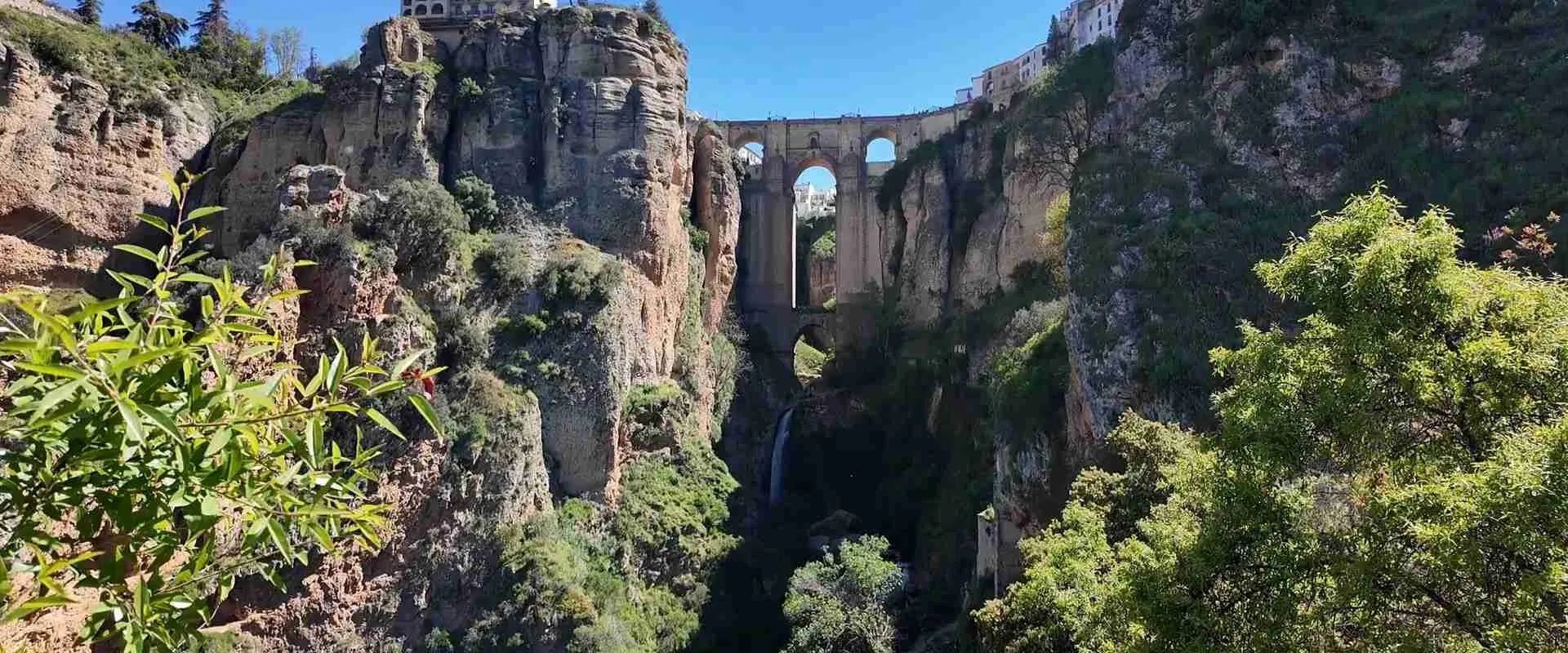
Ronda’s Puente Nuevo and Roman Aqueduct Structures: Deep-Gorge Masonry and 18th-Century Engineering
The El Tajo Gorge cuts through the limestone plateau of Ronda to a depth of more than 120 metres, creating a natural barrier that shaped the city’s defensive history, its hydraulic engineering, and ultimately its most celebrated architectural structure. Three engineering traditions left their marks on this canyon and its hinterland across two millennia: Roman builders at the ancient city of Acinipo, some 20 kilometres distant, exploited rock-cut construction on a limestone plateau; 14th-century Islamic engineers descended through the gorge wall in a fortified stairway to secure a besieged city’s water supply; and 18th-century Enlightenment architects finally bridged the chasm with a three-arch masonry structure whose piers rise 98 metres above the gorge floor. Each episode reveals a structurally distinct response to the same geological constraint, developed independently within the conditions of its own historical moment.
Key Takeaways
- The Puente Nuevo stands 98 metres from its gorge-level base to the road deck and spans 66 metres across El Tajo, making it the tallest and longest of Ronda’s three bridges; the gorge at the crossing point is approximately 120 metres deep.
- The bridge’s completion is attributed to architect José Martín de Aldehuela (1724–1802), who was engaged around 1785 to finalise a project initiated under Domingo Lois de Monteagudo and built by chief builder Juan Antonio Díaz Machuca; the bridge was delivered in May 1793 after some 34 to 42 years of construction, depending on which source’s start date is used.
- A central chamber built into the masonry of the main arch served historically as a prison — including during the Spanish Civil War — and now houses an interpretation centre documenting the bridge’s construction history through scale models and surviving technical drawings.
- The Water Mine at Casa del Rey Moro descends 60 metres through the gorge cliff via 231 steps cut entirely from living limestone, reaching the Guadalevín River through a fortified lower section of interlocked vaulted chambers; the system is dated to the 14th century and associated with the Nasrid-period ruler known as Abomelic (Abu Malik).
- All ashlar stone for the Puente Nuevo was quarried from the gorge floor itself — the obstacle’s own material became the bridge’s fabric — a self-supplying construction logic that had been applied independently centuries earlier in the rock-cut theatre at Acinipo.
- The Segovia Aqueduct and the Pont du Gard are used here as structural reference points to explain how 18th-century bridge engineering chose fewer, larger arches over the many-small-arch tiers of Roman hydraulic construction, exploiting the canyon walls as natural abutments in a way unavailable to aqueduct builders crossing open terrain.
People Also Ask About Ronda’s Deep-Gorge Masonry Engineering
How tall is the Puente Nuevo above the Guadalevín Gorge?
The Puente Nuevo stands 98 metres from its gorge-level base to the road deck above — the figure cited consistently in official documentation from the Diputación de Málaga. The El Tajo Gorge is approximately 120 metres deep at the crossing point, meaning the bridge piers begin above the river surface and the total road-to-water height difference is greater than the bridge structure alone. The bridge’s total length side to side across the gorge is 66 metres and its three-arch arrangement divides that span between two flanking arches and one dominant central arch. A first attempt to bridge the gorge at this height collapsed in 1741 after only a few years of construction, killing approximately 50 workers; the current structure, built between approximately 1751 or 1759 and 1793, has carried continuous traffic for more than two centuries.
Who designed the Puente Nuevo in Ronda?
The completed bridge is most closely associated with José Martín de Aldehuela (1724–1802), the Aragonese architect engaged around 1785 when the project had stalled, who oversaw the work to its completion in May 1793. The original design is attributed to Domingo Lois de Monteagudo, with Juan Antonio Díaz Machuca serving as chief builder and credited with developing the machinery to raise large stone blocks from the gorge floor. Aldehuela, who had also designed Ronda’s neoclassical bullring, refined the design and delivered the bridge that contemporaries and subsequent historians have consistently regarded as his finest work, though the attribution reflects a multi-stage project with several significant contributors across several decades.
What is the Water Mine beneath Casa del Rey Moro?
The Water Mine at Casa del Rey Moro is a 14th-century military hydraulic system cut entirely through the limestone cliff of El Tajo Gorge. Its 231 steps descend 60 metres from city level to the Guadalevín River, giving besieged inhabitants a secured, concealed passage to water without exposure to missile fire above. The lower 30 metres incorporate a small fortress of interlocked vaulted chambers whose layered arch construction allowed defenders to protect the water-collection point from multiple levels simultaneously. The system is generally dated to the reign of the Nasrid-period ruler known in chronicles as Abomelic (Abu Malik), who governed Ronda in the early 1300s when the city occupied a contested frontier position between the Christian north and the newly developing Nasrid Emirate of Granada. Admission is charged to enter the gardens and descend the mine; verify current rates before visiting.
How does Ronda’s masonry engineering compare to Roman aqueduct structures?
Roman aqueduct bridges such as the Pont du Gard and the Segovia Aqueduct solved the challenge of spanning terrain through stacked tiers of multiple smaller arches — a strategy that kept individual arch thrust manageable and distributed loads among many masonry columns, at the cost of construction complexity and the need for many intermediate foundations. The Puente Nuevo belongs to a structurally distinct tradition that favoured a small number of large arches, accepting far greater horizontal thrust per abutment in exchange for simpler construction at span level. The canyon walls of El Tajo function as the bridge’s abutments, absorbing the arch’s thrust directly into living rock — an advantage unavailable to aqueduct builders in open or gently sloping terrain who had to construct their own abutment masses. The Water Mine’s rock-cut staircase and vaulted chambers represent a parallel tradition of subterranean hydraulic engineering that arose independently to meet the same core problem of water access under siege.
Extended multi-day tours – 5+ days
Featured Malaga Multi-Day Tour Packages
3 days
Malaga 3-Day Discovery Tour
- ✓ Comprehensive Malaga experience
- ✓ Expert local guides included
- ✓ All accommodation included
- ✓ Transportation provided

5 days
Malaga 5-Day Highlights Experience
- ✓ Comprehensive Malaga experience
- ✓ Expert local guides included
- ✓ All accommodation included
- ✓ Transportation provided

7 days
Malaga 7-Day Cultural Journey
- ✓ Comprehensive Malaga experience
- ✓ Expert local guides included
- ✓ All accommodation included
- ✓ Transportation provided

10 days
Malaga 10-Day Complete Adventure
- ✓ Comprehensive Malaga experience
- ✓ Expert local guides included
- ✓ All accommodation included
- ✓ Transportation provided
Multi-day tour packages powered by TourRadar. Prices and availability subject to change.
Introduction: Engineering Between Rock Walls — Ronda’s Centuries of Deep-Canyon Construction
Ronda occupies a limestone plateau in the Serranía de Ronda at approximately 750 metres above sea level, and the city’s defining geographic feature is not the plateau surface but the dramatic void that cuts through it. El Tajo Gorge — el tajo means “the cut” — is carved by the Guadalevín River through Jurassic limestone and descends more than 120 metres below the plateau surface at its deepest crossing point, running for approximately a kilometre beneath the historic old town. For the pre-modern city this chasm was simultaneously a defensive asset and a practical constraint: it made Ronda almost impregnable from three sides while making internal circulation, water supply, and urban expansion across the divide continuously difficult.
The title of this article pairs the Puente Nuevo with “Roman aqueduct structures,” and that pairing requires a clarification before the engineering can be examined properly. There is no major surviving Roman aqueduct at Ronda itself. The comparison drawn here is structural and typological: Roman hydraulic construction — as represented most famously by the Segovia Aqueduct and the Pont du Gard in southern France — provides the most instructive structural contrast to the 18th-century bridge engineering of the Puente Nuevo, because both addressed the same core problem of spanning terrain with masonry and arrived at opposite structural strategies. Roman engineering presence near Ronda is documented at Acinipo, an ancient city on a plateau about 20 kilometres distant, whose Roman theatre is the most significant surviving built structure in the region’s Roman-period record. That site will be examined for its own engineering logic in a later section.
Three structurally distinct engineering traditions mark the gorge and its hinterland across two millennia. In the Roman period, builders at Acinipo used the logic of cut-rock construction: excavating directly into the limestone plateau to form a theatre’s seating bowl, then using the removed material as building stone for the stage above — a closed material loop in which the geological constraint yielded its own building fabric. Fourteen centuries later, the Islamic administration of 14th-century Ronda carved a fortified descent shaft through the gorge cliff to the Guadalevín River below, producing a military hydraulic system in which the rock was simultaneously the container of the passage, the material of the defensive vaulting, and the cover that concealed water carriers from attack. And in the 18th century, as the city of Ronda expanded beyond what its older crossings could serve, a sustained construction project produced a three-arch limestone bridge that exploited the gorge’s vertical walls as natural abutments — a structural strategy that gave the Puente Nuevo load-bearing capabilities no bridge in open terrain could match with equivalent masonry technology.
These three traditions are not connected by a chain of transmission. The Roman builders at Acinipo did not teach cut-rock techniques to the Islamic engineers of the Water Mine; the Islamic masons of the Water Mine did not introduce centering or voussoir methods to Aldehuela. Each tradition encountered the same limestone canyon environment equipped with the structural and material knowledge available in its own historical context, and the convergences — rock cutting, ashlar masonry, arch geometry — reflect the convergence of the geological problem rather than any diffusion of solutions between engineering cultures.
What follows examines each episode in structural and historical depth. The article begins with the arch mechanics of the Puente Nuevo itself, then moves to the comparative logic of Roman aqueduct structures, then to the subterranean hydraulics of the Water Mine, and proceeds through the material technologies — ashlar quarrying, lime mortar, timber centering — that made each structure possible. Practical visitor information for each site appears in a dedicated final section.
Structural Statics: Arch Thrust Resistance in Deep Canyon Topography
The fundamental structural principle of any masonry arch bridge is the conversion of vertical gravitational load into diagonal forces that resolve at the arch abutments as horizontal thrust. Masonry cannot resist tension; the material relies entirely on compression, and the geometry of the arch — the curvature of its intrados (inner face) and the taper of each voussoir (wedge-shaped stone forming the arch ring) — determines how efficiently loads are channelled through the material. When the resultant force at any section of the arch falls within the central third of the arch’s cross-sectional depth, the full section remains in compression throughout. When that resultant deviates outside the central zone, tension begins to develop at the less-loaded face, and since masonry has virtually no tensile strength, cracking initiates along that face.
In a conventional flat or gently sloping site, arch abutments must be massive masonry or stonework structures capable of absorbing the horizontal thrust without sliding, rotating, or cracking. At Ronda’s El Tajo Gorge, the canyon walls perform this function without any constructed abutment mass. The near-vertical limestone cliffs that drop 120 metres to the Guadalevín River are effectively infinite abutments — their total mass is many orders of magnitude greater than the horizontal thrust any bridge could deliver, and their bearing surface is living rock rather than a built foundation. This topographic accident transforms the deep canyon from an obstacle into a structural asset: the geological constraint that makes bridge construction so difficult is precisely what makes the completed bridge so structurally efficient. The greater the arch thrust, the more firmly the canyon walls hold — compressive reaction forces in rock increase with applied load rather than failing under it.
The Puente Nuevo’s three-arch configuration — two smaller arches supporting the approach sections from each canyon wall, and one dominant central arch spanning the widest part of the gorge — reflects this structural logic. The flanking arches begin directly from the canyon walls, allowing the structure to step outward from the rock face in a sequence of compression before the main central leap. Each arch in the sequence pushes outward against the next, and the outermost arch in each series pushes into the canyon wall rock. This arrangement, in which multiple arches in series each buttress the next, distributes lateral forces through the masonry mass in a way that keeps individual structural elements compact and the overall thrust path direct. The structural chain is: road traffic loads → arch ring → horizontal thrust → flanking arch → canyon wall abutment.
The piers — the masonry towers that carry the arches and stand 98 metres above the gorge floor — are the dominant structural element in terms of material volume. They must carry the weight of arch rings and road deck above while withstanding wind pressure and the asymmetric thrust that develops when the arch is under non-uniform loading: a heavy vehicle on one half of the arch with nothing on the other half moves the thrust line away from the arch’s geometric centre, potentially bringing it closer to the tension-prone outer face. At the height of 98 metres, the lateral stability of slender masonry piers is also a design consideration: overturning from wind loads is resisted by the self-weight of the piers themselves, a strategy that demands adequate pier cross-section to generate sufficient stabilising moment.
The 98-Meter Chambered Arch Design by Architect José Martín de Aldehuela
The heading that identifies this bridge design uses “98-meter” to describe the bridge’s total height from gorge floor to road deck, and attributes the design to José Martín de Aldehuela. Both designations are correct within their proper scope, and both benefit from the contextualisation the historical record supports.
The 98 metres refers to the structural height of the bridge from its gorge-level foundation to the road surface above — the measurement confirmed by the Diputación de Málaga and by multiple detailed site accounts. This is not the horizontal span of the central arch, which bridges the gorge at deck level across a total length of 66 metres including approaches. The 98-metre figure captures the vertical dimension of the entire engineering enterprise: the depth at which the pier foundations engage the canyon walls above the gorge floor, plus the height of the arch and pier masonry above that engagement point, plus the road deck and parapet at the top. Visitors standing on the bridge deck and looking directly down into the gorge experience the full 98 metres as the distance between themselves and the gorge floor below.
The “chambered” element refers to a built-in room within the masonry body of the bridge at approximately mid-height of the central arch — an interior space accessible through a former guard-house building on the old-town side of the bridge deck. This chamber was incorporated into the bridge’s design from the outset, not added later. Its intended original use has been debated, but from its earliest decades it served as a prison for the city of Ronda, holding convicted criminals and later, during the turbulent politics of the 19th century, political detainees. During the Spanish Civil War of 1936–39, both sides in the conflict reportedly used the chamber as a place of detention and interrogation, and accounts from the period describe prisoners being thrown from the chamber windows into the gorge below — a fate of some 98 metres. Today the chamber has been converted into an interpretation centre, open to visitors through the former guard-house, with exhibits documenting the bridge’s construction history through scale models, period drawings, and explanatory panels.
The attribution of the design to Aldehuela encapsulates a multi-stage construction history that sources do not fully agree on in every detail. What the record does consistently support is the following sequence. An earlier bridge at this same crossing point — built rapidly over perhaps six to eight months around 1734 by the builders José García and Juan Camacho — collapsed in 1741, killing approximately 50 workers, almost certainly because its centering was removed prematurely or its arch geometry was insufficient for the span. The current bridge was then undertaken as a properly engineered replacement, with construction beginning at a date that different sources give as either 1751 or 1759 — a discrepancy that likely reflects different reference points for design approval versus physical construction start. The original design for the current bridge is attributed by Wikipedia and by the local historical account published by RondaToday to Domingo Lois de Monteagudo, an architect of established reputation working in Andalusia at the time. The chief builder Juan Antonio Díaz Machuca oversaw the construction, and is specifically credited in contemporary accounts with designing the lifting machinery that raised large stone blocks from the gorge floor — an innovation that addressed one of the most challenging practical logistics of the entire project.
By approximately 1785 the bridge was still far from complete, and the civil administrators of Ronda called on José Martín de Aldehuela to bring the project to a conclusion. Aldehuela had been born on 16 January 1724 in Manzanera, in the province of Teruel in Aragon, and had by the 1780s accumulated a substantial practice in Andalusia. He had worked extensively in Málaga — on the cathedral, on its Episcopal Palace, and on numerous smaller ecclesiastical commissions — before designing Ronda’s Plaza de Toros, the elegant neoclassical bullring that opened in 1785. His intervention in the Puente Nuevo between approximately 1785 and its completion in May 1793 is documented in local records and is the consistent basis on which both civic tradition and subsequent historical scholarship identify the bridge as his work. A story circulated in subsequent generations that Aldehuela, on hearing that a newer and more beautiful bridge might be needed, threw himself from the structure he had just completed — a colourful anecdote that the historical record refutes: Aldehuela lived until 7 September 1802, dying in Málaga well after the bridge’s completion. The Mirador de Aldehuela — the overlook on the Mercadillo (market quarter) side of the gorge from which the best elevation view of the bridge is obtained — is named in his honour, the most permanent memorial to the man most lastingly identified with the structure.
Roman vs. Age of Enlightenment Hydraulic Construction
The most fundamental structural contrast between Roman hydraulic architecture and 18th-century Spanish bridge engineering is the ratio of individual arch span to overall structure height. Roman aqueduct construction typically deployed many small arches arranged in one, two, or three superimposed tiers to carry a water channel across a valley or ravine, each individual arch spanning a relatively modest distance — typically from five to around fifteen metres — while the tiers stacked vertically to achieve the elevation required by the hydraulic gradient. The 18th-century masonry arch bridge, working within a tradition that had progressively extended arch-span capability through medieval vault construction and Renaissance engineering experimentation, favoured a small number of large arches, sometimes a single dominant arch, capable of bridging the full width of a river crossing or gorge in one or two bays.
The structural logic behind each strategy reflects different primary design requirements. The Roman aqueduct was first and foremost a water-delivery machine: its governing variable was the continuous hydraulic gradient required to convey water from source to city without mechanical pumping. The gradient determined the deck height at every point along the aqueduct’s length, and that height had to be reached in a way that was structurally stable, constructionally feasible with the materials and labour available, and hydraulically correct — a deviation in gradient that allowed water to pool, overflow, or stagnate was not merely aesthetic but functional failure. Under these constraints, multiple smaller arches are the conservative engineering choice: each arch generates relatively modest horizontal thrust; the thrust is distributed among many compression columns; those columns are compact, efficient, and require modest foundations; and the overall construction can proceed bay by bay with standardised centering that is struck, moved, and reused at each successive span.
The road bridge responds to a different set of constraints. The road itself simply needs to reach from one side to the other at the height of the plateau surface, with no prescribed gradient and no hydraulic function. This structural freedom opens the possibility of a single large arch that crosses the full width of a valley or gorge in one span — structurally more demanding per abutment but constructionally simpler at the span level. The canyon walls of El Tajo, as discussed above, make the abutment problem trivially easy: horizontal thrust is absorbed by the living rock with no risk of overturning or sliding. The only remaining engineering challenges are the arch centering (the temporary timber structure required to support the masonry during construction) and the precision of the voussoir cutting — both non-trivial, but both solvable with the timber engineering and masonry dressing technology available in 18th-century Spain.
Comparative Load Distributions with Segovia Aqueduct and Pont du Gard
The Segovia Aqueduct in Castile is the most visible illustration of the Roman multiple-arch strategy in the Iberian Peninsula. The structure carries a water channel across a valley through the city of Segovia on two superimposed tiers of arches, reaching a maximum height of approximately 28 metres at the tallest section and extending about 728 metres through the urban area. The lower tier provides the height increment with less material than a solid wall; the upper tier carries the specus (the covered water channel). Structurally, the most remarkable feature of the Segovia Aqueduct is that its granite blocks are laid entirely without mortar — the whole structure relies on the precise geometric fit of the blocks and the compression of gravity to remain in place. Each block presses against its neighbours, and the system of compression distributes the weight of the entire aqueduct through this purely mechanical contact. No binding agent, no iron tie, no mechanical fastener is used in the primary structural masonry. This extraordinary fact confirms the Roman mason’s confidence in the arch as a self-locking compression device: geometry, not adhesion, provides stability.
The Pont du Gard in southern France is taller and structurally more complex. Three tiers of arches reach approximately 49 metres above the Gardon River, carrying a covered channel on the uppermost level that once supplied the Roman colony of Nemausus (Nîmes) from springs near Uzès, roughly 50 kilometres distant. The first tier has six arches spanning the river valley; the second tier has eleven arches providing additional height; the third tier is divided into thirty-five smaller arches that carry the channel directly. The dimensional logic of the three-tier arrangement reflects a clear structural hierarchy: the widest, most widely spaced arches at the base (where the load from two tiers above must be carried) and progressively smaller, more closely spaced arches at higher levels (where only the channel load acts). The limestone at the Pont du Gard is mortared, unlike Segovia’s dry-set granite, and the distinctive bosses — protruding stone lugs on the arch faces — served as anchor points for the timber centering during construction, their presence confirming a Roman willingness to leave constructional evidence visible on the completed structure.
Both structures exemplify the Roman principle of load distribution through multiplication: many arches, each carrying a manageable load and generating manageable thrust, each requiring only a modest foundation column. The Puente Nuevo responds to a structurally opposite principle: concentrate the crossing into the fewest possible arches, accept the higher per-arch thrust at each abutment, and rely on the geological mass of the gorge walls to absorb that thrust without constructed foundations. Neither strategy is inherently superior — each is correct for its engineering problem. The Roman aqueducts needed to maintain a continuous hydraulic gradient across moderate terrain where large natural abutment masses were not available; the multiple-arch approach gave them redundancy, constructional repeatability, and manageable thrust at each span. The Puente Nuevo needed to cross a 120-metre-deep gorge whose near-vertical walls offered unlimited abutment capacity; the large-arch approach minimised the number of intermediate foundations required in the gorge’s difficult terrain and exploited the canyon’s compressive geology to maximum advantage.
There is also a significant difference in the loading character of the two structure types. A Roman aqueduct carries a relatively constant dead load: the weight of its own masonry plus the water in the channel above, a slow-moving, low-intensity live load. A road bridge carries an inherently variable live load: vehicles of varying weight stopping and starting at unpredictable positions across the span. This variability in load position moves the arch’s thrust line back and forth within the cross-section, requiring the arch geometry to accommodate a range of thrust-line positions rather than a single calculated line. Masonry arch bridges of the Puente Nuevo’s period typically incorporated generous cross-sectional depth in the arch ring — the voussoirs are deep relative to the span — precisely to keep the thrust line within the central third across the full range of likely live-load positions. The Roman aqueduct, with its stable dead load and slow-moving water, could use relatively thinner arch rings because the thrust line varied little in position.
Subterranean Military Hydraulics: The Water Mine of Casa del Rey Moro
In any pre-gunpowder siege, the most reliable path to capturing a strongly fortified city was not assault but attrition: cut the water supply, wait, and accept surrender when the wells ran dry. This strategic reality shaped the defensive hydraulic engineering of every medieval fortified city in Europe and the Islamic world, and the response of each fortification depended on its local geology, its internal water resources, and the engineering capability of its administration. Ronda — the Islamic city of Medina Runda — under its 14th-century Nasrid-period government produced what local preservation authorities and published site guides describe as one of the most sophisticated — and most unusual in Spain — surviving examples of this defensive hydraulic logic: the Water Mine (Mina de Agua) cut into the limestone cliff below what is now known as Casa del Rey Moro.
The site of Casa del Rey Moro (House of the Moorish King) occupies the gorge edge of the old town, immediately south of the Puente Nuevo. Despite its name, the current 18th-century building was never a royal Moorish palace — it was constructed in the 18th century on the site of earlier Islamic fortifications and derives its name from the medieval hydraulic system below rather than from any documented royal residence. The gardens visible today were designed in 1912 by the French landscape architect Jean-Claude Nicolas Forestier in a Moorish-inspired Mediterranean style — a 20th-century addition that has no structural relationship to the medieval engineering beneath it, though it creates the pleasant paradox of a serene terraced garden concealing one of the most militarily purposeful rock-cut structures in Spain. The house currently remains closed to visitors following fire damage, but the gardens and the Water Mine descent are accessible on payment of admission.
Islamic Vertical Staircase Shafts (Mina de Agua) Cut in Living Rock
The term “vertical staircase shafts” in this section’s heading captures the essential construction method: the water mine is a passage cut downward through the gorge cliff by deliberate excavation of the living limestone. It is more precisely described as a stepped descending tunnel than a true vertical shaft in the engineering sense (which would imply a near-plumb drop with laddering rather than steps), but the terminology reflects the same fundamental technique — penetrating rock by removing it, rather than building over or around it.
The passage begins at city level, accessible through the Casa del Rey Moro property, and descends 60 metres through the cliff of El Tajo Gorge to the level of the Guadalevín River below. The descent is accomplished via 231 steps cut directly into the limestone, following a winding path through the cliff that approximates a zigzag or helical trajectory — each flight of stairs runs at a manageable slope for approximately 10 to 15 steps before turning or reversing direction, allowing the passage to traverse the cliff’s thickness without requiring any stair flight to be dangerously steep. The width of the passage is sufficient for a person carrying a loaded vessel to move without difficulty; the height is sufficient to stand, though the ceiling descends in places where the natural rock required minimal modification.
The geological material of the cliff — the same Jurassic limestone that forms the gorge walls and was quarried for the Puente Nuevo — determined both the possibility and the character of the excavation. Limestone of this formation responds well to iron cutting tools: it is hard enough to be durable but amenable to steady percussion work with chisels and hammers, and it tends to fracture along natural joint planes in directions that facilitate rather than resist the cutter’s intent. The 14th-century masons who excavated the Water Mine were not breaking rock at random but following and exploiting the rock’s natural tendency to separate along existing fracture surfaces, trimming and squaring these natural planes rather than cutting against the grain. This skill — reading the fracture geometry of a particular stone body and quarrying with rather than against it — is the same skill that allowed the builders of the Puente Nuevo to extract useful ashlar blocks from the gorge floor with iron tools and no blasting.
The lower 30 metres of the descent differ qualitatively from the upper stairway. Here, within the cliff, the engineers built a small fortress — a series of interconnected vaulted chambers constructed using what site documentation describes as a latticework of stacked arches, which allowed defenders stationed at different levels to protect the water-collection point simultaneously. The structural logic of these chambers is the same compressive logic of the arch: by spanning the space between rock walls with a masonry vault rather than a flat lintel, the engineers converted the weight of rock above into compression along the arch haunches, directing load around the void rather than across it as tension. This is the same structural reason all masonry tunnels use vaulted profiles — the arch eliminates the tension that a flat ceiling would experience under the weight of overburden above, and masonry can resist the compression the arch generates while it cannot resist the tension a flat ceiling would require.
The military function of the fortified lower section is straightforward to reconstruct. An enemy who succeeded in locating and breaching the mine entrance at river level would then face the lowest vaulted chamber, capable of being held by a small number of defenders against a narrow-front assault from below. Even if the lowest chamber were taken, each successive chamber higher in the cliff could be independently held, meaning that the attacker would need to fight through multiple defended positions — in conditions of extreme physical difficulty, moving upward through narrow openings — while the city’s water carriers continued to operate from chambers above. The system transforms a potentially catastrophic vulnerability (a secret descent to the water source) into a defensible asset: the mine is only operationally compromised if every chamber is overrun simultaneously, which the layout makes effectively impossible.
The system’s construction is generally dated to the reign of Abomelic (Abu Malik), a Nasrid-affiliated ruler of Ronda in the early decades of the 14th century, when Ronda was a front-line independent Islamic polity caught between the expanding Castilian and Aragonese Christian kingdoms to the north and the developing Nasrid Emirate of Granada to the east. Constant threat of siege — and the historical experience of what siege meant for a city without a secured water supply — would have made the Water Mine not an engineering luxury but a survival infrastructure investment. After the Reconquista’s completion with the fall of Ronda to Ferdinand and Isabella in 1485, the siege conditions that justified the mine ceased to exist, and the system gradually passed from active military use to historical curiosity and eventually to its current status as a publicly accessible heritage site.
Local historical accounts, recorded after the Christian conquest in 1485, report that the mine was operated during sieges using enslaved Christian prisoners as water carriers — the only people compelled to make the physically demanding descent repeatedly under battle conditions. This detail, recorded in post-conquest testimonies cited in chronicles of the Reconquista period, provides the most vivid available evidence of the mine’s operational character: not just an engineering system but a militarised labour process. The engineering was only as effective as the labour system that operated it.
Ashlar Masonry Technology: Extracting, Dressing, and Setting Local Limestone
Ashlar masonry is distinguished from rubblework by the quality of preparation applied to each individual stone. A rubblework wall uses stones roughly as they come from the quarry or river, with minimal dressing and irregular coursing; the masonry is tolerably stable for low-rise walls but generates uneven stress concentrations that limit its load-carrying capacity. An ashlar wall uses stones that have been individually dressed — typically squared on all faces, with the bed joints (horizontal surfaces) cut to consistent planes so that each course rests evenly on the one below and load transfers uniformly across the full joint area. The result is masonry capable of receiving and distributing the large concentrated loads that occur at arch springing points and at the bases of tall piers — precisely the conditions the Puente Nuevo imposes on its structure.
The Gorge as Its Own Quarry: Self-Supplying Construction at Scale
One of the most practically significant facts about the Puente Nuevo’s construction — confirmed in official provincial documentation and repeated in detailed site accounts — is that the ashlar stone from which the bridge is built was quarried from the floor of the El Tajo Gorge itself. This is not a minor logistical detail but a defining characteristic of the entire construction operation.
The implications of gorge-floor quarrying are several and interlocking. First, it eliminated the transport cost for the heaviest component of the construction. In 18th-century Spain, moving large masonry blocks across terrain required draft animals, wheeled vehicles, and usable roads. None of these assets would have been readily available for delivering stone to a construction site at the edge of a 120-metre gorge, and even if they were, each block would have had to be moved to the gorge edge and then lowered or raised as needed. By quarrying within the gorge itself, the builders placed their stone source directly below the construction site and reduced the transport problem to a single vertical operation: lifting from below rather than horizontal movement from a distance.
Second, gorge-floor quarrying in a karst limestone canyon produces stone of appropriate character for ashlar work. The natural jointing of the Jurassic limestone at El Tajo — bedding planes, vertical fractures, and diagonal joint sets — breaks the rock into roughly tabular or blocky fragments that a mason can dress to regular faces with less cutting than would be required if the rock came out in spheroidal or irregular forms. The masons working the gorge floor were cooperating with the rock’s existing fracture geometry, using wedges, chisels, and hammers to exploit the joints rather than break across them.
Third, the act of quarrying progressively cleared the gorge floor of loose and fractured material at the crossing point, improving the foundation conditions for the bridge piers. Any unsound rock removed during quarrying was removed precisely from the zone where the bridge needed to bear against the canyon walls — a constructional side effect that constituted a form of foundation preparation carried out simultaneously with material extraction.
Juan Antonio Díaz Machuca’s contribution to this operation — the design of machinery for raising stone from the gorge floor to the working level — was a significant engineering achievement in its own right. As the bridge rose higher in the gorge, the vertical lifting distance increased, and the machinery needed to be reconfigured accordingly. The basic mechanical principle was almost certainly a crane arrangement with a windlass (a rotating drum driven by a hand-operated capstan or lever arms), ropes, and a lifting frame, anchored at the canyon wall surface. The weight of a large ashlar block — a dressed stone of perhaps 0.3 cubic metres, weighing roughly 700 to 800 kilograms in limestone — is within the range manageable by a team of workers at a hand-operated windlass, though the operation would have been slow and demanding. Díaz Machuca’s documented innovation was presumably in the specific configuration of this machinery for the unusual spatial constraints of a narrow deep gorge, where conventional crane arrangements designed for flat-ground construction sites could not simply be applied without modification.
The voussoir stones for the arch rings demanded the most precision dressing of any blocks in the project. Each voussoir must be tapered — the inner face shorter than the outer face — by an angle that matches the arch’s curvature at that position. In a semicircular arch, every voussoir has the same taper angle; in an arch of different profile, the angle varies across the ring. The central keystone must be cut to fit precisely between the two half-rings of voussoirs from each side, and its correct placement under the compressed arch is the moment at which the centering is no longer structurally necessary — a moment of critical operational significance during construction. Any deviation in voussoir cutting that prevents the keystone from entering its position cleanly creates a gap at the crown that cannot be corrected without removing and re-dressing multiple stones.
The lime mortar used to bed the Puente Nuevo’s ashlars and fill the joints is a geochemical system with a time dimension that distinguishes it from modern Portland cement. Hydraulic lime is made by burning limestone (calcium carbonate, CaCO₃) in a kiln at sufficient temperature to drive off carbon dioxide, producing calcium oxide (CaO), then slaking with water to form calcium hydroxide (Ca(OH)₂). The slaked lime, mixed with sand and water as a paste, sets initially through chemical reaction and then continues to carbonate over decades and centuries as it slowly reabsorbs atmospheric CO₂, returning toward calcium carbonate — the original mineral composition of the limestone from which it came. Old, well-carbonated lime mortar in a properly maintained masonry bridge may be harder and more weather-resistant than freshly set mortar, and in well-built structures of this period the mortared joints tend to weather preferentially over the surrounding stone, opening slightly and allowing moisture movement without building up hydraulic pressure within the masonry body — a mechanism that actually protects the stone from spalling by relieving rather than concentrating moisture stresses.
Arch Centering Over the Void: Timber Falsework Engineering for a 98-Metre Canyon
A masonry arch is not self-supporting during construction. From the first voussoir placed at the springing point — where the arch leaves the pier or abutment — to the penultimate voussoir just short of the keystone, each stone in the arch ring is pushing downward on the structure below it and trying to slide outward along the curved arch surface. The compressive self-locking that will eventually hold the arch in place without any external support cannot develop until the keystone is inserted and the arch becomes a complete closed ring. Until that moment, every voussoir must be held in its correct geometric position by an external support structure — the centering, or falsework — that temporarily carries the weight and maintains the arch’s form.
For the Puente Nuevo’s central arch, spanning the widest section of a 120-metre-deep gorge, the centering presented an engineering challenge of extraordinary complexity. The requirements were demanding on multiple dimensions simultaneously. The centering had to span the gorge at the arch level — a horizontal distance of at minimum the main arch span, plus an allowance for the structure’s own supports. It had to carry the full weight of all masonry placed on it during the construction of the arch ring, potentially many hundreds of tonnes of dressed limestone. It had to resist wind pressure — significant at an open gorge crossing at 98 metres elevation — and the vibration and dynamic loading transmitted by workers and stone-setting operations. It had to maintain dimensional accuracy throughout the construction season, because any deflection of the centering would produce a corresponding permanent deviation in the arch geometry that could compromise structural performance for the bridge’s entire lifetime. And it had to be designed for eventual removal: after the keystone was placed and the arch self-supported, the centering had to be struck — lowered carefully — without transmitting shock loads to the newly completed masonry ring.
Timber centering for a major masonry arch was typically constructed as a series of parallel curved ribs following the arch intrados profile, cross-braced and connected by horizontal purlins and planking to create a working platform on which stones could be laid and dressed. The curved ribs were themselves built up from short timber members scarf-jointed (lapped and pegged) to form the required curvature, since no timber in natural form provides a curved member of the radius needed for a large arch rib. The supporting structure for the centering — the props and staging that held the rib assembly at the correct height above the gorge — could be built upward from the gorge floor if the floor was accessible and the height not excessive, or suspended from the canyon walls by brackets and ties, or both. At 98 metres above the gorge floor, some combination of wall-anchored brackets and cross-gorge timber members was almost certainly necessary, since staging built from the gorge floor would need to rise nearly the full gorge depth before the arch centering could even begin.
The collapse of the first Puente Nuevo in 1741 — the bridge built by García and Camacho in approximately six to eight months — almost certainly resulted from inadequate centering, premature striking of centering before the arch had developed sufficient strength, or insufficient engagement of the arch with its canyon-wall abutments. Rapid construction timelines for masonry arches are inherently risky: lime mortar requires time to set and gain initial strength before loads are applied, and a centering struck too early imposes on incompletely hardened masonry the full load of its own dead weight plus any live loads from traffic or construction activity. A bridge built in eight months across a 120-metre gorge is a bridge whose centering was almost certainly not given adequate time to allow mortar setting before being subjected to operational loads. The approximately 50 deaths attributed to the collapse represent the human cost of this miscalculation.
The subsequent construction campaign for the present bridge — 34 to 42 years depending on the source’s start date — reflects a fundamentally different operational philosophy. Multi-decade timelines for major 18th-century masonry bridges were not unusual, but at Ronda the extended schedule appears also to reflect the specific logistical complexity of the site: the gorge-floor quarrying, the lifting machinery, the centering over the void, and the precision voussoir cutting all required sequential staging that could not be compressed without increasing risk. The completion in May 1793, timed to coincide with Ronda’s Royal Fair (Real Feria), suggests that the final phase of construction — likely the arch ring completion, keystone placement, and centering removal — was planned and executed with sufficient confidence in the schedule to be announced in advance.
The precise nature of the timber centering used for the Puente Nuevo’s main arch has not been preserved in documentary form accessible to this study. The Interpretation Centre in the bridge chamber reportedly includes scale models of the construction sequence, which likely incorporate some reconstruction of the centering arrangement, but the technical drawings from which such reconstructions would derive are not publicly accessible. What can be inferred structurally is that the centering for an arch of this height and span in 1790s Spain would have drawn on the accumulated timber engineering knowledge of 18th-century European bridge construction — the same technical tradition that had produced major masonry arch bridges across France, Britain, and Italy throughout the 17th and 18th centuries — adapted to the specific constraint of the gorge setting by Díaz Machuca and Aldehuela.
Karst Limestone and Canyon Geology: How the Guadalevín Gorge Shaped Every Design Decision
The rock that forms El Tajo Gorge — and from which the Puente Nuevo is built — is Jurassic limestone, a sedimentary carbonate rock deposited in warm, shallow marine environments approximately 150 to 200 million years ago and subsequently uplifted by the Alpine orogeny that formed the Baetic Cordillera of southern Spain. Jurassic limestones in this region are typically massive (thick-bedded), pale grey to cream in colour, and of good to excellent compressive strength in fresh, unweathered condition. Unconfined compressive strength values for Mediterranean Jurassic limestones of this character generally range from around 50 to more than 100 megapascals in intact material, far exceeding the stress levels to which bridge masonry is subjected under normal loading — the stone itself is not the structural limiting factor.
The gorge is a product of karstification: the progressive dissolution of limestone by slightly acidic groundwater, the same chemical process by which the stone’s carbonate minerals — primarily calcite — are selectively removed along fracture planes and bedding joints over geological time. El Tajo is a karst slot canyon, produced when the Guadalevín River exploited an existing fracture set in the limestone, widening and deepening its channel over hundreds of thousands of years while the surrounding plateau, less exposed to the river’s dissolving action, remained at higher elevation. The result is the characteristic gorge geometry: near-vertical walls of exposed limestone, a narrow canyon floor, and the dramatic depth-to-width ratio — the gorge at the Puente Nuevo crossing is approximately 120 metres deep but only 66 metres wide — that makes the site simultaneously one of the most defensible natural positions in Andalusia and one of the most challenging bridge-building environments in Spain.
The karst character of the limestone creates both advantages and uncertainties for engineering use. The fracture patterns and bedding planes produced by dissolution — the same joints and planes that guided El Tajo’s formation — are the pre-cut surfaces that 14th-century and 18th-century stone-cutters exploited to extract blocks without blasting. The rock’s natural tendency to separate along these planes means that a skilled mason can produce approximately tabular or blocky pieces with relatively modest chisel and wedge work, needing mainly to dress the exposed faces to regularity. This is why karst limestone regions have historically supported intensive ashlar masonry construction: the quarrying technique and the product are simpler than in crystalline igneous or metamorphic rocks where no natural joints guide the extraction.
The engineering uncertainty introduced by karstification is subsurface void structure. Dissolution does not proceed uniformly through a limestone mass: water concentrates along certain fracture pathways, dissolving them preferentially and leaving intact rock between the zones of active dissolution. The result is a rock mass that may be perfectly intact and strong at one point and contain a dissolution cavity — a void ranging from millimetres to metres in size — at the next point with no surface indication of the difference. Builders working without subsurface investigation methods — no core drilling, no seismic survey, no ground-penetrating radar — could inspect the rock at the exposed surface but could not be certain of conditions within the cliff. The Puente Nuevo’s canyon-wall abutments, set into exposed rock faces that could be inspected and tested by direct sounding and probing over large areas, offered more subsurface confidence than foundation pads in the gorge floor would have done: a void in the canyon wall face would be visible during the abutment preparation work, while a void in the gorge floor under a constructed pier would not be detectably visible until settlement revealed it.
The same dissolution chemistry that formed the gorge continues to operate, at geological rates, on the canyon walls and on the bridge masonry itself. Rainwater in the Mediterranean climate, slightly acidified by dissolved carbon dioxide from the atmosphere and from vegetation, dissolves calcium carbonate from exposed limestone surfaces at rates that are geologically rapid but architecturally slow: a few tenths of a millimetre per year in exposed conditions, much less in sheltered conditions. Over the two centuries since the bridge’s completion, surface recession of this order on exposed faces amounts to a few centimetres of cumulative loss — not structurally significant in itself, but enough to open and widen existing joint planes if the mortar is not maintained. The bridge’s lime-mortar joints, as already noted, tend to weather faster than the surrounding stone, producing open joints that allow moisture movement — typically a beneficial weathering mode, but one that needs monitoring to ensure that moisture penetration into the masonry body remains limited.
Biological colonisation adds a chemical dimension to the weathering process. Algae, lichens, and mosses establish on permanently or intermittently damp masonry surfaces — particularly in the shade conditions of the gorge where the bridge’s lower faces may receive little direct sunlight and dry incompletely between rain events. Lichens in particular secrete organic acids that attack the limestone surface, and root penetration by mosses and small plants can mechanically widen existing joints. Conservation maintenance on the Puente Nuevo includes periodic clearance of biological growth from the masonry faces and re-pointing of deteriorated lime-mortar joints — standard interventions for historic masonry of this age in this climate.
Acinipo: Roman Structural Engineering in the Ronda Hinterland
Acinipo is an ancient city on a limestone plateau at approximately 999 metres above sea level, located roughly 20 kilometres northwest of modern Ronda in the province of Málaga. The site has been continuously occupied from the Neolithic period, with Bronze Age and Copper Age material also attested, and Phoenician trade connections evidenced by amphora fragments. By the 1st century BC, Acinipo had developed into a substantial Roman municipium — minting its own coins, as confirmed by numismatic evidence — and was documented by the Roman geographers Ptolemy and Pliny the Elder under its name. It is sometimes referred to as Ronda la Vieja (Old Ronda) in later Spanish geographical tradition, though the site and modern Ronda (ancient Arunda) coexisted as separate settlements during the Roman period rather than representing a sequential occupation of the same site.
Some historians attribute the city’s expansion to veterans of Julius Caesar’s legions following the Battle of Munda in 45 BC, though the evidence for this specific foundation narrative is not definitive. What the archaeological record does confirm is that Acinipo achieved municipal status and considerable prosperity during the early imperial period, the same era that saw the construction of major Roman civic infrastructure across Hispania Baetica. The city declined beginning in the 3rd century AD, with most of its remaining population transferring to Arunda (the more defensible cliff-top site of modern Ronda) before the site was apparently abandoned entirely, its position noted in medieval sources primarily as a topographical reference point rather than an occupied settlement. The first recorded archaeological observation of the theatre as a Roman structure was made in 1650; systematic archaeological excavations did not begin until 1967, and much of the site remains unexcavated today.
The Rock-Cut Theatre Cavea and Its Material Logic
The most significant surviving structure at Acinipo — and the most structurally illuminating for the engineering comparison this article develops — is the Roman theatre, one of the oldest examples in the Iberian Peninsula and notable enough in its preservation to continue hosting outdoor performances today. The theatre’s most important constructional feature is its cavea: the semicircular seating bowl was not built on a constructed embankment or on the system of vaulted substructures typical of Roman theatres on flat ground, but was excavated directly into the natural limestone of the plateau. The seating tiers — the graduated steps on which spectators sat — are cut into the living rock, using the hillside’s natural gradient to provide the slope necessary for sightlines to the stage below.
This rock-cut construction logic is structurally elegant for several reasons. By cutting into the rock rather than building above it, the Roman engineers avoided the entire system of vaulted corridors, access passages, stairways, and supporting arches that a constructed-embankment cavea required — structures visible in abundance at theatres such as the Theatre of Marcellus in Rome or the Roman theatre at Orange in France, where the terrain did not offer a natural hillside gradient. At Acinipo, the hillside was both the structure and the seating simultaneously: earth and rock provided the mass, the gradient, and the seat treads in a single geological given. The engineering challenge was not how to build up to the required form but how to cut down to it — a problem of subtraction rather than addition.
The removed material did not go to waste. Sources confirm that the limestone extracted during the cavea excavation was used as the primary building material for the stage wall (the scaena frons) and the lateral boundary walls of the theatre’s perimeter. The rock-cut cavea and the built stage thus formed a closed material loop: excavation of one element provided material for the other. The theatre’s stage wall, several metres high, retains portions of its original ashlar-dressed limestone facing in the lower courses, preserving sufficient evidence of the construction technique to confirm this self-supplying material logic.
This is the same material loop independently applied centuries later in the Water Mine’s construction — where excavation of the rock-cut passage produced limestone rubble whose better-quality pieces may have been used in the vaulted lower chambers — and in the Puente Nuevo’s construction, where gorge-floor quarrying provided both material for the bridge and preparation for the foundation zone. All three engineering traditions, working with the same karst limestone environment, arrived independently at the same practical solution: the obstacle’s own material solves the construction problem. Geological constraint and construction resource were the same thing.
The Acinipo theatre’s dating to the late 1st century BC is supported by its architectural form — the cavea geometry and the stage wall proportions are consistent with theatres of the Augustan period and the late Republic — and by the broader context of Acinipo’s documented prosperity in this period. The theatre’s capacity has been estimated variously at approximately 2,000 to 3,400 spectators, with the higher figure drawn from Frank Sear’s systematic reference study of Roman theatres and the lower figure cited in some regional guides. The disparity reflects uncertainty in the cavea geometry’s full extent, parts of which remain partially obscured by soil accumulation at the seating flanks. The theatre is still in use for outdoor performances — a practical confirmation that the acoustic qualities generated by the hillside cavea geometry, directing reflected sound toward the performance space, remain effective after two millennia.
The Acinipo plateau’s elevation at 999 metres also shaped the Roman construction in ways that parallel the gorge-edge challenges at Ronda: the plateau’s exposed position meant that the theatre’s open-air cavea was subject to wind, and the stage wall’s height and mass served partly to shelter the performance space from prevailing southwesterly winds that characterise this part of the Serranía de Ronda. The combination of functional acoustic geometry and pragmatic wind-shelter in a single structure is a characteristic Roman quality of solving multiple problems with single forms.
Conservation, Structural Monitoring, and Heritage Status of the Puente Nuevo
The Puente Nuevo has carried continuous road traffic since its completion in 1793, serving first the pedestrian, equestrian, and cart traffic of the 18th and 19th centuries and then, from the 20th century, motor vehicles of progressively increasing weight and frequency. The masonry arch is a structurally forgiving form under increasing live load — unlike steel or reinforced concrete bridges, which respond to load increase by proportionally increasing stress in individual structural elements, a masonry arch bridge can redistribute its thrust line within the masonry cross-section to accommodate varying load distributions, as long as the line remains within the arch’s structural depth. Historical evidence from surviving 18th- and 19th-century masonry arch bridges throughout Europe consistently shows that well-built structures of this period carry traffic loads many times greater than anything the original designers anticipated, without structural distress, precisely because of this redistribution capacity.
The Puente Nuevo nevertheless presents specific conservation challenges rooted in its exposed canyon environment and the geochemical character of its limestone and lime-mortar fabric. The most pervasive weathering process is surface dissolution of the limestone by acidic precipitation — the same karstification chemistry that formed the gorge. Mediterranean rainfall in Andalusia, typically concentrated in autumn and winter, carries dissolved carbon dioxide and, in areas with atmospheric pollution, traces of sulfur dioxide, both of which produce slightly acidic precipitation capable of dissolving calcite from exposed masonry surfaces. The rate of dissolution on the Puente Nuevo’s exposed faces is geologically modest — millimetres per decade rather than centimetres — but is sufficient over two centuries to have opened surface texture and exposed the rock’s micro-porosity to increasing moisture uptake.
The bridge’s setting introduces a moisture regime that accelerates some weathering processes. The gorge microclimate is typically more humid and cooler than the surrounding plateau surface: the canyon walls shelter the gorge interior from wind and direct sun, moisture from the Guadalevín River evaporates upward through the gorge air column, and the bridge surfaces in shade receive limited drying. Sections of the bridge permanently in shade — particularly the undersides of the arch rings and the inner faces of the piers — may remain persistently damp, creating favourable conditions for biological colonisation by algae, cyanobacteria, mosses, and ultimately lichens and small vascular plants. Biological growth on masonry is cosmetically problematic and, at higher organism size, structurally relevant: lichen thalli chemically attack the stone surface, and root systems of established mosses and small plants can apply mechanical pressure in existing joints sufficient to open them further over years and decades.
Conservation maintenance is an ongoing responsibility for the bridge’s administrative steward, the Diputación de Málaga, which manages the Puente Nuevo as one of the province’s most important cultural monuments. Standard maintenance operations include the periodic cleaning of biological growth from masonry faces, the re-pointing of deteriorated lime-mortar joints with compatible lime-based mortars (Portland cement is not used in conservation re-pointing of historic masonry because it is too rigid and too strong, generating the kind of restraint stresses at its interface with old lime mortar that cause cracking and spalling of the adjacent stone), and the monitoring of any settlement or rotation at the abutment zones. The bridge also carries active vehicular traffic, which generates dynamic loading — vibration and impact from vehicle wheels — that must be managed to prevent progressive fatigue damage to lime-mortar joints at the arch ring.
The bridge is a protected cultural monument under Spanish heritage legislation, and this status governs what interventions can be made to its fabric. Any modification to the exterior masonry surfaces — re-pointing, cleaning, structural injection of cracks — requires documentation and approval under heritage protection protocols. The interior chamber (the interpretation centre) has been modified to accommodate its exhibition function, but the chamber’s structural role as part of the bridge masonry remains unchanged. The chamber’s windows, through which prisoners were allegedly thrown during the Civil War, now frame views into the gorge that are as vertiginous as any in Spain — a reminder that the bridge’s history encompasses purposes far removed from road transport.
Visiting the Puente Nuevo, El Tajo Gorge Viewpoints, and Casa del Rey Moro
The three primary engineering subjects of this article occupy a compact section of Ronda’s historic old town, walkable in a sustained half-day or comfortable full day. Physical demands and access conditions differ considerably between the sites, and sensible planning requires knowing the differences in advance.
The Puente Nuevo bridge deck is free to cross at any time and open to both pedestrian and vehicular traffic without restriction. Walking across gives an immediate sense of the gorge’s scale from directly above, but provides limited structural views. The arch geometry and masonry construction become legible from the vantage points described below.
The Mirador de Aldehuela (the Aldehuela overlook), on the Mercadillo side of the gorge, is reached by a path descending from the new-town area to a belvedere platform directly opposite the bridge. From here, the full three-arch elevation is visible in near-frontal view, making the relative proportions of the central arch and the flanking arches immediately legible — the essential structural diagram of the bridge. This is the correct position from which to study the arch geometry, the masonry coursing of the piers, and the location of the chamber opening at mid-pier height. Photography from this point is most effective in morning light, when the bridge faces are illuminated from the east.
The Balcón del Coño viewpoint on the Paseo de la Alameda, at the gorge edge of the new town, offers a more oblique and vertiginous perspective looking along the gorge axis, emphasising the bridge’s height rather than its breadth. This is the vantage point that best conveys the relationship between the bridge and the canyon walls — the arch abutments embedded in the rock faces — and gives the clearest sense of why the canyon walls were the structural solution to the lateral thrust problem.
The gorge floor trails, accessible from the Casa del Rey Moro garden or by path from other points on the gorge periphery, bring the visitor to the base of the bridge piers and allow direct inspection of the abutment zones where the masonry meets the living rock. The 98-metre height of the bridge becomes viscerally comprehensible from this position in a way that no elevated viewpoint can replicate. Allow adequate time for the ascent back to plateau level and wear appropriate footwear for rough terrain.
The Interpretation Centre within the bridge chamber (the former prison) is accessed through the guard-house building on the old-town side of the bridge deck. A small admission fee is charged, and at the time of research a fee of approximately €2–3 per adult was cited by local visitor guides, though this should be confirmed before visiting as prices are subject to change. The centre’s scale models of the construction sequence are the most useful single resource for understanding how the bridge was built — they reconstruct the centering arrangement, the pier construction sequence, and the machinery used to raise stone — and complement the structural narrative of this article with three-dimensional physical models. Opening hours vary seasonally; check current times through Ronda’s official tourism office before planning a visit.
Casa del Rey Moro is on Calle Santo Domingo at the gorge edge of the old town, south of the Puente Nuevo. The 18th-century house currently remains closed for restoration following fire damage, but the terraced gardens (Forestier, 1912) and the Water Mine are open. Admission to the garden and mine descent is charged; visitor sources cited fees in the range of €7–10 per adult, with the RondaToday site noting €10 as the standard price, but these figures should be confirmed directly before visiting. The descent through the mine’s 231 steps takes 30 to 45 minutes down and 30 to 45 minutes back up, the return being considerably more physically demanding than the descent. Non-slip footwear is essential: the lower sections are permanently damp and the carved limestone steps can be slippery. The site is open daily with extended hours in summer; verify current closing times through the site’s official contact or through Ronda tourism services before visiting.
Acinipo (the Roman theatre site, also known as Ronda la Vieja) requires private transport: it is approximately 20 kilometres from central Ronda along the road toward Seville, with no reliable public bus connection. The site is managed by the Junta de Andalucía and has historically operated with intermittent closures for conservation work. Confirming the current opening status before making the journey is strongly recommended. Allow half a day for a round trip from Ronda including a thorough visit to the theatre, the visible forum remains, and the partial baths structure. The site’s plateau position at 999 metres gives panoramic views of the Serranía de Ronda that are themselves worth the drive.
Frequently Asked Questions About Ronda’s Masonry Structures
Why did the first Puente Nuevo collapse in 1741?
The first bridge to span El Tajo at the height of what is now the Puente Nuevo was built around 1734 by builders José García and Juan Camacho in approximately six to eight months — an extraordinarily short construction period for a masonry arch over a 120-metre gorge. Contemporary accounts describe it as a rushed and precarious structure, and it collapsed in 1741 killing approximately 50 workers. No definitive engineering analysis of the failure survives, but the short construction timeline strongly suggests that the centering — the timber falsework supporting the masonry arch during construction — was either inadequately designed, removed before the lime mortar had gained sufficient strength, or that the arch’s engagement with its canyon-wall abutments was insufficient to contain the horizontal thrust. Rapid construction of masonry arches is inherently risky because mortar requires time to set before load can be safely applied; striking centering prematurely imposes the arch’s dead load on incompletely set mortar, typically initiating crack progression that leads to collapse.
How did engineers raise stone blocks to the working level without modern equipment?
Chief builder Juan Antonio Díaz Machuca is specifically credited in contemporary accounts with designing machinery to raise large stone blocks from the gorge floor to the working level — an operation that became progressively more demanding as the bridge rose higher. The basic mechanical principles would have included crane arms, windlass systems (rotating drums driven by hand-operated capstans), ropes of hemp or other fibre, and lifting frames, all anchored at available points on the canyon walls. The same lifting technology had been documented by Vitruvius in ancient Rome and was described in detail in 18th-century European engineering manuals; Díaz Machuca’s specific contribution was adapting these principles to the unusual constraints of a narrow deep gorge where the only anchoring points were the vertical rock faces. A team of workers at a well-rigged hand windlass could manage blocks of several hundred kilograms, though the operation was slow and physically intensive for both the machine operators and those guiding the stone into position.
What makes the Segovia Aqueduct structurally unique compared to other Roman bridges?
The Segovia Aqueduct’s most remarkable structural feature is that its granite blocks are laid entirely without mortar — the entire structure of approximately 728 metres and two tiers of arches at a maximum height of about 28 metres is held together purely by the geometric compression of the arch and the weight of the blocks pressing against each other. No bonding agent, no iron clamp, no mechanical connector is used in the primary structural masonry. This dry-set construction demonstrates the Roman mason’s complete reliance on arch geometry as a self-locking compression device: the wedge-shaped voussoirs cannot slide apart because the adjacent voussoirs and the weight of the structure above resist any movement. The Segovia Aqueduct has maintained this mortar-free structural integrity since its construction, probably in the 1st or 2nd century AD, through more than nineteen centuries of service — a testament to the precision of the original stonecutting and the stability of the arch geometry.
How many steps are in the Water Mine and how long does the descent take?
The Water Mine descends via 231 steps cut directly into the limestone of El Tajo Gorge’s cliff face — a figure cited consistently in the site’s own documentation and in detailed visitor accounts. The total descent covers approximately 60 metres of vertical difference between the city level and the Guadalevín River below. The stairway follows a winding path through the cliff rather than a direct line, which distributes the descent over a greater horizontal distance and keeps individual stair flights at manageable angles. The descent itself takes approximately 30 to 45 minutes at a careful pace, with the return climb taking an equivalent or slightly longer time. The lower 30 metres pass through the fortified section of vaulted chambers and are permanently damp; the remainder varies seasonally. Non-slip footwear and reasonable fitness are prerequisites for the round trip.
Was the Puente Nuevo’s chamber always used as a prison?
The chamber built into the masonry of the Puente Nuevo’s central arch appears to have served as a prison from the bridge’s early decades, though its intended original function at the time of design is not fully established in the sources reviewed here. From the late 18th century onward it was documented as a detention facility for the city of Ronda. During the Spanish Civil War of 1936–39, both Republican and Nationalist forces reportedly used the chamber for holding, interrogating, and in some accounts killing prisoners; the gorge below the chamber’s windows was the destination of some who did not survive detention. The chamber was subsequently decommissioned as a penal facility and eventually converted into the current interpretation centre, which opened to visitors and presents the bridge’s construction history through models, documentation, and period accounts. The bridge chamber’s layered history — engineering space, prison, wartime detention facility, heritage museum — mirrors the layered history of Ronda itself.
How does El Tajo Gorge’s geology benefit the Puente Nuevo structurally?
The El Tajo Gorge’s near-vertical karst limestone walls serve as the Puente Nuevo’s abutments — the structural elements that absorb the horizontal thrust generated by the arch. In a conventional bridge site, abutments must be massive constructed masonry or concrete structures capable of resisting overturning and sliding under the applied horizontal force. At El Tajo, the canyon walls are effectively infinite abutments: their mass is many orders of magnitude greater than any bridge thrust, and their bearing surface is living rock rather than built masonry. This geological advantage allows the Puente Nuevo to develop an arch of considerable span and generate significant horizontal thrust without requiring any constructed abutment infrastructure at the gorge level. The gorge that made crossing the Guadalevín River so difficult also provided the structural conditions that made the eventual crossing extraordinarily efficient.
Who were the original designers of the Puente Nuevo before Aldehuela?
The original design for the current Puente Nuevo — the bridge that replaced the collapsed 1741 structure — is attributed to Domingo Lois de Monteagudo, an architect active in Andalusia at the time. Construction under Lois de Monteagudo’s design began either around 1751 or 1759, depending on which source’s start date is used for the construction campaign as opposed to the design approval. The chief builder throughout much of the project was Juan Antonio Díaz Machuca, who is specifically credited with developing the machinery for raising stone blocks from the gorge floor and is regarded as the primary construction engineer of the project’s main phases. When the project stalled around 1785 with the bridge still incomplete, José Martín de Aldehuela was engaged to bring it to conclusion. He completed the bridge in 1793, and the convention of attributing the bridge primarily to Aldehuela reflects both his role in finalising the design and the civic tradition that has been consistent in this attribution since the bridge’s completion.
What is the structural significance of the Pont du Gard’s three-tier arch design?
The Pont du Gard’s three-tier arrangement — six wide arches at the base, eleven narrower arches in the middle tier, and thirty-five small arches in the uppermost level that carries the water channel — reflects a clear structural hierarchy adapted to the loading conditions at each level. The lowest tier carries the greatest load (the weight of two full tiers above plus the water channel) and therefore uses the widest, most widely spaced arches to distribute this load over many supporting columns. The middle tier carries one full tier above it plus the channel, so uses somewhat narrower and more closely spaced arches. The uppermost tier carries only the channel load and uses many small arches that can be closely spaced without the structural penalty of redundant masonry mass. This graduated arch-size system distributes total dead load efficiently through the full height of the structure, achieving a 49-metre crossing with individual arch spans that remain well within the range manageable with Roman mortar technology and timber centering.
How do the Roman theatre at Acinipo and the Water Mine share a common engineering logic?
Both the Acinipo theatre’s rock-cut cavea and the Water Mine at Casa del Rey Moro use the same fundamental approach: excavate directly into living limestone to create the required space, rather than building a structure above or around the terrain. At Acinipo, the seating bowl (cavea) was cut into the hillside, and the removed limestone was used to build the stage wall — excavation of one element provided material for the other. At Casa del Rey Moro, the passage and stair system were cut through the gorge cliff, with the removed limestone potentially contributing to the vaulted defensive chambers at the base. Both traditions also exploit the structural stability of rock-cut spaces: when a void is created within rock by subtraction rather than built above it by addition, the surrounding rock provides self-supporting containment for the void’s ceiling, needing only minimal secondary reinforcement (arch vaulting in the Water Mine’s lower section) at points where the natural span exceeds the rock’s ability to bridge without support. The convergence of technique reflects the convergence of the geological problem — both engineering programmes worked with limestone that responded to the same cutting tools and provided the same structural conditions — rather than any connection between the Roman builders of the 1st century BC and the Islamic engineers of the 14th century AD.
Is the Water Mine accessible to visitors today and what physical condition is required?
The Water Mine (Mina de Agua) is accessible to visitors through the Casa del Rey Moro site on Calle Santo Domingo in Ronda’s old town. The 18th-century house itself currently remains closed for restoration, but the terraced gardens and the mine descent are open daily (hours vary seasonally — confirm current times before visiting). Admission covers both the gardens and the mine; visitor sources cited fees in the range of €7–10 per adult, though this should be verified directly. The descent of 231 steps to the Guadalevín River level covers approximately 60 metres of vertical difference and is physically straightforward going down but demanding on the return climb. The lower section of the mine is permanently damp and the carved limestone steps can be slippery; non-slip footwear is essential and is effectively a requirement rather than a recommendation. The mine is not suitable for visitors with mobility impairments, for very young children who cannot manage 200-plus steps safely on uneven terrain, or for those with cardiac or respiratory conditions that make sustained stair climbing inadvisable. For physically prepared visitors the site offers an experience unavailable anywhere else in Spain — a complete, accessible medieval military hydraulic system preserved in the rock it was cut from.