Perched Above the Red Rocks: Defensive Engineering at Castell d’Eramprunyà in Catalonia
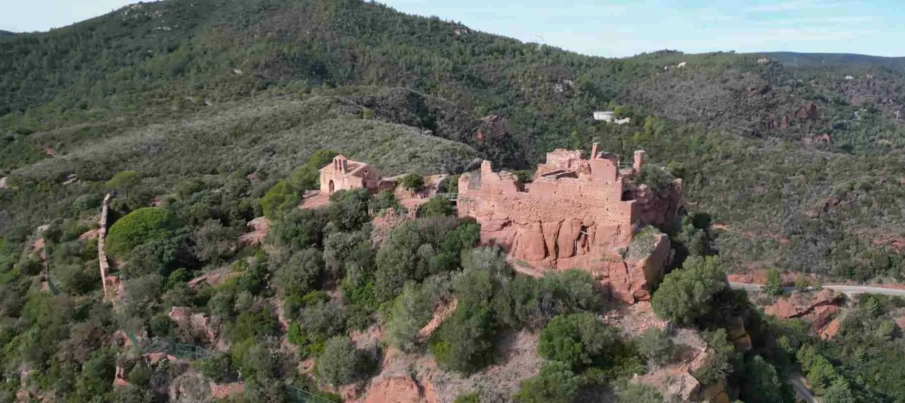
Perched above the Llobregat delta at the edge of the Garraf Massif, Castell d’Eramprunyà commanded the southern Carolingian frontier from a summit barely accessible on three sides. First documented in 957, the fortress grew through Romanesque and Gothic phases as each generation of builders pressed the topography into service — anchoring walls to cliff faces, carving cisterns from bedrock, and positioning watchtowers to surveil the plain. This guide traces those engineering decisions, situates the castle within the medieval signal network of the Catalan coastal range, and draws comparisons with cliff-edge fortification traditions from Crusader Jordan and Himalayan Bhutan.
Key Takeaways
- Castell d’Eramprunyà, first documented in 957, served as the administrative and military center of the Barony of Eramprunyà, controlling the southern approach to Barcelona along the Llobregat River corridor and the coastal plain for more than four centuries.
- The castle’s three concentric fortified enclosures were integrated into the Garraf Massif summit at approximately 400 meters above the coastal plain, exploiting sheer cliff faces on the northern, eastern, and southern flanks as the primary defensive perimeter — leaving only the western approach to be secured by masonry walls and a ditch bridged by a drawbridge.
- The eastern Garraf’s geological composition — primarily limestone with zones of reddish siliceous sandstone and Triassic conglomerate — supplied the building material for the curtain walls and the bedrock substrate from which the principal cistern was excavated directly into the rock between the chapel and the castle complex.
- A network of hilltop fortifications across the Baix Llobregat comarca, with Eramprunyà as its dominant elevated node, extended visual signaling capacity along the Carolingian-era frontier established on the Llobregat River following the Frankish conquest of Barcelona in 801.
- Colònia Güell, founded in 1890 by the industrialist Eusebi Güell in the same Baix Llobregat landscape, represents a nineteenth-century transformation of the same logic of territorial enclosure — defined perimeters, controlled access, and centralized authority over a dependent community — that the medieval barony had exercised from the rocky summit above.
People Also Ask About Castell d’Eramprunyà
What is Castell d’Eramprunyà and why is it significant to the history of Catalan defensive architecture?
Castell d’Eramprunyà is a medieval fortified complex in the municipality of Gavà, Baix Llobregat, Catalonia, rising on a rocky summit at approximately 400 meters above sea level at the southeastern margin of the Garraf Massif. It is first mentioned in a document of 957, and architectural evidence suggests construction developed across several major phases between the tenth and fourteenth centuries. The castle served simultaneously as a military fortification against incursions from the south, as the administrative seat of the Barony of Eramprunyà covering the modern municipalities of Gavà, Begues, Castelldefels, Sant Climent de Llobregat, Viladecans, and part of Sant Boi de Llobregat, and as a primary node in the visual signaling network linking the Llobregat River frontier to the Garraf highlands.
Its architectural significance rests on two characteristics that distinguish it within the wider corpus of Catalan medieval fortification. First, the builders achieved an unusually deep integration of masonry construction with the natural geometry of the summit: walls were anchored to, and in places built directly from, the living cliff faces rather than placed on leveled artificial foundations. Second, the three-enclosure layout — sovereign upper, jussà lower, and outer — created a graduated system of defensive depth that channeled any attacker through a sequence of increasingly fortified thresholds, extracting maximum value from the natural slope differential of the site. The castle was designated as a Bé Cultural d’Interès Nacional — a property of national cultural interest — in 1988, and the municipality of Gavà has administered it since 2007, undertaking ongoing structural consolidation in partnership with the Diputació de Barcelona.
How did medieval builders at Eramprunyà exploit the natural rock escarpment to anchor cisterns and defensive walls?
The central technique was geological integration: wherever technically possible, walls were not built as freestanding structures but were initiated at points where the cliff face itself served as the lowest course of masonry. Where rock rose vertically, it became a foundation immune to undermining; where it rose at an angle, masonry was keyed into fissures and stepped natural ledges rather than resting on a separate footing. This approach reduced the volume of dressed stone required, eliminated the risk of settlement failure on the steep rocky slopes, and made the base of each wall effectively proof against both direct battering and the undermining operations that were a standard component of medieval siege craft.
The cistern excavated between the chapel of Sant Miquel d’Eramprunyà and the main castle complex illustrates the same principle applied to water infrastructure. Rather than constructing a cistern from plastered masonry tanks — always susceptible to mortar failure and seepage at a location far above any natural water table — the builders carved the cistern directly into the summit rock, producing a waterproof container whose walls and floor were the geological substrate itself. This rock-cut reservoir, open to the sky for rainwater collection, could sustain a strategic water reserve without relying on any masonry element that might crack, delaminate, or fail under siege conditions. The technique represents a systematic, rather than incidental, exploitation of the site’s geological properties.
What is the relationship between Castell d’Eramprunyà’s medieval fortification design and the industrial colony planning of Colònia Güell?
The connection is thematic rather than genealogical: both represent a form of deliberate territorial enclosure exercised over a dependent population in the same Baix Llobregat landscape, separated by roughly seven centuries and organized by entirely different mechanisms of authority. The medieval castle imposed military and jurisdictional control over surrounding villages through the physical dominance of the fortified summit, the legal apparatus of the feudal term, and the presence of armed retainers. Colònia Güell, founded by Eusebi Güell in 1890, imposed a structurally comparable form of control through different means: a bounded perimeter of worker housing, schools, a cooperative store, and a cultural center — all under company ownership — that created a self-contained community whose daily life remained within the spatial, economic, and social oversight of the Güell enterprise.
Both models also share a characteristic relationship to landscape: the castle dominated its territory from above through visibility and inaccessibility; the industrial colony dominated its workers through completeness of provision and deliberate geographic isolation from the urban labor market. Neither was primarily interested in landscape as scenery; both used it instrumentally as a medium of control. That the spatial logic of the contained community subject to central authority could be realized in such radically different architectural forms — Gothic curtain walls versus modernist brick housing — suggests how persistent certain organizational patterns in territorial planning can be across very different historical eras.
How does the cliff-edge defensive masonry of Castell d’Eramprunyà compare with Crusader fortresses and Bhutanese dzongs?
Castell d’Eramprunyà, the Crusader castle at Kerak in Jordan, and the dzong fortress-monasteries of Bhutan represent three traditions of elevated cliff-edge fortification that developed without contact with one another and arrived at parallel solutions to a shared military-engineering problem: how to use a rocky summit or spur to maximize defensive return from a given volume of masonry. The convergence across these independent traditions reflects the universal physical constraints of hilltop defense — gravity, siege technology, and the geometry of escarpments produce similar optimal responses regardless of cultural context. At Eramprunyà and Kerak alike, builders concentrated masonry investment on the one accessible approach and allowed natural cliff faces to substitute for constructed walls elsewhere. At Bhutanese dzongs, hilltop or river-spur siting eliminated the need for defensive perimeters on the steeper sides in the same way. All three traditions also solved the problem of water supply under siege conditions, most often by exploiting topographic features — rock-cut cisterns at Eramprunyà and Kerak, river-adjacent siting and internal storage at many dzongs. The differences are as instructive as the similarities: each tradition calibrated its solutions to specific threat environments, available materials, and seismic or climatic conditions.
Extended multi-day tours – 5+ days
Featured Barcelona Multi-Day Tour Packages

3 days
Barcelona 3-Day Discovery Tour
- ✓ Comprehensive Barcelona experience
- ✓ Expert local guides included
- ✓ All accommodation included
- ✓ Transportation provided

5 days
Barcelona 5-Day Highlights Experience
- ✓ Comprehensive Barcelona experience
- ✓ Expert local guides included
- ✓ All accommodation included
- ✓ Transportation provided
7 days
Barcelona 7-Day Cultural Journey
- ✓ Comprehensive Barcelona experience
- ✓ Expert local guides included
- ✓ All accommodation included
- ✓ Transportation provided

10 days
Barcelona 10-Day Complete Adventure
- ✓ Comprehensive Barcelona experience
- ✓ Expert local guides included
- ✓ All accommodation included
- ✓ Transportation provided
Multi-day tour packages powered by TourRadar. Prices and availability subject to change.
The Marca Hispanica Frontier: Origins and Strategic Context of Eramprunyà
To understand why a castle was built on the rocky summit above the modern town of Gavà, it is necessary to begin more than a century before the first document that names the site. In 801, a Frankish army commanded under Louis the Pious captured Barcelona from its Moorish garrison, extending the Carolingian defensive perimeter south of the Pyrenees into the Iberian Peninsula. The administrative entity that emerged from this expansion, the Marca Hispanica, required a territorial frontier line behind which the Frankish counts could organize agricultural colonization, taxation, and military mobilization while maintaining a defensible buffer against the powerful Emirate of Córdoba to the south. That frontier line, as established in the post-801 settlement of the Carolingian conquest of Barcelona, ran along the Llobregat River.
The Llobregat was not a particularly wide or difficult river, and it did not in itself constitute an adequate defensive barrier. What the frontier designation meant, rather, was that the hilltops, valleys, and mountain passes controlling movement across the Llobregat corridor required systematic fortification. The southeastern edge of the Garraf Massif, where the limestone and sandstone ridges descend sharply toward the coastal plain before the Llobregat mouth, was one of the most strategically sensitive sections of this entire line. Movement from the south toward Barcelona had to pass either along the narrow coastal strip between the Garraf cliffs and the sea — where no army could maneuver effectively in any force — or through the lower Llobregat valley, which opened the approaches to the city from the interior. A fortified hilltop at approximately 400 meters above this valley, with unobstructed sightlines over the coastal plain and the delta, was thus not merely a useful military position but a near-indispensable one.
The first written evidence for Castell d’Eramprunyà appears in a document of 957, during a period when the Counts of Barcelona, who had progressively separated themselves from direct Carolingian authority during the ninth and early tenth centuries, administered the frontier castles of the southern march. The document records the castle as an existing structure, implying a foundation in the previous generation at the earliest. Historians of Catalan medieval fortification have proposed, on the basis of documented patterns elsewhere in the Llobregat corridor, that an initial phase of fortification at the summit may date to the late ninth or early tenth century, when the Counts of Barcelona were actively reinforcing their southern frontier against increasingly aggressive pressure from the Moorish taifa states. No primary source naming the founders of the initial structure has been identified, and the precise form of the earliest phase of construction remains a matter of inference from the documentary record and from the architectural evidence recovered during consolidation work carried out by the Servei de Patrimoni Arquitectònic Local of the Diputació de Barcelona from 2010 onward.
What the documentary and archaeological record establishes with greater confidence is that the castle developed through multiple distinct construction phases between the eleventh and fourteenth centuries, each representing a significant investment in masonry infrastructure at the summit. The Romanesque chapel of Sant Miquel d’Eramprunyà, which occupied the lower enclosure, is attributable on stylistic grounds to the twelfth century, making it the most precisely dateable surviving architectural element of the complex. The Gothic castle-palace in the upper sovereign enclosure, whose ruins remain on the highest point of the summit, reflects construction activity in the thirteenth and fourteenth centuries — a period when the Counts of Barcelona, and later the Aragonese crown, were engaged in extensive refortification of their frontier and interior castles in the context of territorial expansion toward the south. The outer enclosure, whose defensive wall retains the most complete standing sections today, is believed to date to the period of Marc family ownership in the fourteenth and fifteenth centuries, when the territorial and jurisdictional organization of the barony was consolidated in its final medieval form.
Throughout all of these phases, the castle functioned not only as a military fortification but as the administrative center of a substantial feudal territory. The Eramprunyà Castle Term — the medieval precursor to the modern municipalities of Gavà, Begues, Castelldefels, Sant Climent de Llobregat, Viladecans, and a portion of Sant Boi de Llobregat — was governed from the castle through its lord’s judicial, fiscal, and military authority over the resident population. This dual function, military and administrative, is a characteristic feature of frontier castles throughout the medieval Crown of Aragon and reflects the integration of territorial governance with physical defense that defined feudal organization across Catalonia and beyond.
Geological Integration in High-Altitude Castle Foundations
Describing Eramprunyà’s summit as “high-altitude” in the technical sense of altitude as absolute elevation above sea level requires immediate qualification: at approximately 400 meters, the castle sits well below the elevations conventionally associated with high-altitude engineering challenges. The term is precise, however, in the strategic and topographic sense that most directly governed the builders’ decisions. The summit rises from a coastal plain that lies at or near sea level, producing a relative relief of roughly 400 vertical meters between the castle floor and the delta below. This differential is what creates the “high-altitude” conditions the builders exploited — exceptional sightlines in all directions, severe access difficulty from the east, south, and north where cliff faces drop sharply, and the problem of water supply at a height far above any natural water table. The engineering challenges of the site were those of any high-elevation fortification, regardless of the absolute meter figure on the contour map.
The Garraf Massif that provides the geological substrate for the castle is classified as a karstic limestone range — a characterization accurate for the massif’s dominant rock type and for its spectacular internal topography of dolines, shafts, and underground drainage systems. But the eastern flank of the Garraf, where Eramprunyà sits, is geologically more varied than this summary suggests. Travellers and geologists have long distinguished three separate color zones within the Garraf landscape: the white Garraf of Mesozoic limestone with its Mediterranean scrub flora; the red Garraf, in which siliceous sandstone outcrops dominate, giving the hillsides and rocky faces a warm ochre-to-rust coloration; and the black Garraf of Paleozoic schists and slates along the northwestern margins. The summit of Eramprunyà falls within or near the zone of transition between the white and red Garraf, where Triassic Buntsandstein red conglomerates and sandstones appear beneath the Mesozoic limestone succession, and where the cliff faces and rock exposures take on the reddish-to-orange tones that the castle’s popular name, and the title of this article, reflect.
This geological context is not merely a matter of scenic description. It directly determined the materials available to the castle’s builders and the specific properties of the substrate into which they anchored their foundations, cisterns, and wall bases. The reddish siliceous sandstone and iron-rich conglomerate of the transitional zone provided a building stone of moderate workability and substantial compressive strength. Lime mortar prepared with aggregate from the iron-bearing local formations takes on a characteristic warm, reddish-buff color that is still visible in surviving wall sections, constituting what the technical focus of this study identifies as the castle’s red sandstone mortar binding. The use of this local stone not only reduced transport costs — an important consideration for construction on an almost inaccessible summit — but ensured that the mortar and the masonry units were mineralogically compatible, reducing differential expansion and contraction under the temperature swings of the exposed hilltop site.
Strategic Exploitation of Natural Escarpments for Cistern and Wall Anchoring
The practical genius of Eramprunyà’s builders lay not in any single striking structural innovation but in the systematic extraction of defensive advantage from every feature of the summit’s natural geometry. Medieval castle construction on level or gently sloping terrain faced a consistent set of challenges: the foundation had to be secured against settlement on disturbed or heterogeneous ground; the base of each wall had to be protected against undermining operations by which attackers could weaken or collapse sections of the perimeter; and large volumes of building stone had to be quarried, transported, and dressed to create the full height of the defensive circuit. At Eramprunyà, the cliff topography largely solved all three problems simultaneously wherever it could be engaged.
Wall sections that began directly at a vertical or near-vertical rock face were immune to undermining, since any excavation at the base would encounter the living rock rather than a constructed footing in loose fill. The rock face also served as the lower course, or series of courses, of the wall itself, eliminating the need to quarry, transport, and lay that material in the form of dressed stone. In the sovereign enclosure — the highest and most fortified section of the complex, whose walls reached thicknesses of up to fifty centimeters in the surviving sections — the close integration of masonry with the natural cliff geometry is still visible in the remaining wall stubs, where the transition between the natural rock surface and the laid masonry above it follows the irregular contour of the underlying formation rather than a straight horizontal joint. This is precisely what would be expected if builders were keying their first masonry course into a rough cliff face rather than setting it on a prepared horizontal surface.
The bastion guarding the western entrance — the only approach to the castle that did not face an impassable drop — required a different engineering response. Here, without the benefit of natural cliff protection, the builders invested in wall mass: the bastion’s southern wall, which formed part of the primary defensive line against any assault from the accessible western side, reached a documented thickness of ninety centimeters. This thickness is nearly double that of the walls in the sovereign enclosure, reflecting a rational calculation: where nature provided no protection, masonry had to compensate, and the wall facing the main threat sector had to be heavy enough to resist both direct battering and the projectile bombardment that a well-equipped attacking force would direct at the access point.
The cistern between the chapel of Sant Miquel d’Eramprunyà and the castle proper represents the most concentrated expression of the geological integration strategy. Hewn directly from the summit rock and open to the sky for rainwater collection, this cistern provided the garrison with a water reserve that required no masonry container and presented no mortar joint that could crack under freeze-thaw cycling or structural settlement. The volume and precise morphology of the cistern have not been fully published in the available secondary literature, but its existence as a rock-cut feature rather than a built tank is documented in both the Catalunya Medieval survey of the site and in the patrimony records of the Gavà municipality. The strategic importance of such a reservoir at a site that could be subjected to prolonged siege — the 1469 siege by Generalitat troops that ultimately destroyed much of the castle is evidence enough that siege was a real threat at Eramprunyà — can scarcely be overstated. A garrison that controls its own water supply independent of external access retains bargaining leverage and fighting capacity long after food, firewood, and other consumables begin to run short.
Secondary cistern-related features may have existed in the outer enclosure, though the current state of preservation and the available published documentation do not permit confident identification of additional rock-cut water infrastructure beyond the principal cistern. The use of anthropomorphic tombs — grave recesses carved directly into the bedrock near the chapel and castle — further attests to the systematic practice of rock-cutting at the site, demonstrating that the tools and skills for cutting into the summit rock were part of the regular repertoire of the builders and masons who worked at Eramprunyà across its medieval construction phases.
Defensive Wall Geometry along the Llobregat River Delta Frontier
The geometric organization of the castle’s defensive circuit must be understood in direct relationship to the topography of the Llobregat River delta and the coastal plain that it controlled. Standing at the sovereign enclosure, a medieval garrison officer would have possessed visual command of an extraordinary arc of territory: the Llobregat floodplain extending northward toward the confluence with the Anoia and Cardener rivers; the coastal strip and the sea beyond; the approaches through the lower Garraf valleys from the southwest; and, in clear weather, the outlines of Barcelona and its harbor to the northeast. This panoramic control was not incidental to the castle’s military value — it was its primary military value, the characteristic that made the rocky summit above Gavà worth the considerable effort of building and supplying a fortress there at all.
The siting of the three enclosures was determined by this sightline requirement combined with the constraint of the accessible western approach. The sovereign enclosure at the summit occupied the highest and most visually commanding position, from which the maximum surveillance field could be maintained. Its walls followed the irregular contour of the highest rock outcrop, enclosing the Gothic castle-palace building and the associated structures of the lord’s residence and the garrison’s immediate headquarters. Below and slightly to the east, the jussà enclosure housed the chapel of Sant Miquel d’Eramprunyà, the cemetery — attested by the anthropomorphic rock-cut graves surrounding the chapel — and what appear to have been secondary buildings associated with the religious and domestic life of the complex. The relationship between the two upper enclosures was managed by a ditch and a drawbridge, giving the garrison the option of withdrawing entirely to the sovereign enclosure and cutting off access from below if the lower enclosure fell to attackers.
The outer enclosure at approximately 319 meters, substantially lower than the two upper enclosures, extended the castle’s defensive perimeter outward to a point where the slope gradient first began to ease and where the natural cliff protection diminished. Its defensive wall — which retains some of the most complete standing sections anywhere at the site — was likely added during the period of Marc family consolidation in the fourteenth or fifteenth century, reflecting a deliberate expansion of the fortified circuit as the barony’s territorial authority and material resources grew. This outer wall served a different function from the cliff-edge masonry of the upper enclosures: where those walls could rely heavily on the natural topography to do the defensive work, the outer enclosure wall had to stand on its own as a built barrier against potential attackers who had successfully crossed the lower approaches from the west.
The combined defensive geometry of the three enclosures thus created a layered system of obstacles calibrated to the site’s topography. An attacker approaching from the west — the only practical direction — would first need to breach or circumvent the outer enclosure wall, then ascend to the jussà enclosure and overcome the additional wall and the ditch separating it from the sovereign enclosure above, and finally storm the sovereign enclosure itself on its highest and most defensible ground. Each stage of this advance would cost the attacker time, casualties, and cohesion, while exposing the assault force to fire from the defenders still holding the next level upward. The system is not geometrically complex — it lacks the sophisticated flanking towers and angled bastions of later Renaissance fortification — but it represents a highly effective adaptation of the three-dimensional site to the military realities of medieval assault tactics, with curtain walls placed precisely where the natural topography could not substitute for them and omitted or minimized wherever the cliff faces themselves performed the defensive function.
The Barony of Eramprunyà: Territorial Lordship and Military Architecture
The military architecture of Castell d’Eramprunyà cannot be properly understood in isolation from the administrative and jurisdictional apparatus that it housed and anchored. The castle was not merely a garrison post but the physical and symbolic center of the Barony of Eramprunyà, a feudal territorial unit of considerable extent that gave the castle its sustained economic and demographic base and its reason for continued investment across the eleventh to fourteenth centuries. Without the surplus agricultural income extracted from the surrounding villages as rent, service obligation, and judicial fines, the castle could not have been maintained as an active military installation, and without the castle as a symbol and instrument of lordly authority, the barony’s jurisdictional claims over the same villages would have been far more difficult to enforce.
The territory of the Eramprunyà Castle Term covered a substantial arc of the southern Baix Llobregat, from the coastal municipality of Castelldefels in the south to the inland municipality of Begues in the Garraf hinterland, including the lowland agricultural communities of Gavà, Viladecans, Sant Climent de Llobregat, and a significant portion of Sant Boi de Llobregat. This was not a compact defensive perimeter but an extended jurisdiction, and maintaining it required both the credible threat of military force — which the castle provided — and a local administrative and juridical apparatus that could collect dues, adjudicate disputes, and mobilize the rural population for military service when required. The castle functioned as courthouse, treasury, prison, and garrison in one: its architectural program had to accommodate these diverse functions within a physically restricted summit site, which explains the otherwise puzzling presence of a Romanesque chapel within the lower enclosure — religious observance, legal assembly, and garrison life were all concentrated within the castle’s walls.
For the first three and a half centuries of its documented existence, Eramprunyà remained directly dependent on the Counts of Barcelona, who exercised direct overlordship of the castle and the barony rather than granting it out to an intermediary magnate. This direct comital ownership of a strategically critical frontier installation reflects the political priorities of the Counts of Barcelona during the period of Catalan territorial expansion: the Llobregat frontier was too important to trust to a vassal whose loyalty, however reliable under normal conditions, might be tested in the event of a crisis on the frontier. The castle’s first change of ownership came in 1323, when King Jaume II of Aragon sold the castle and barony to the Marc family, who would maintain ownership for nearly two centuries.
The chapel of Sant Miquel d’Eramprunyà, positioned in the jussà enclosure, represents the most architecturally intact medieval element of the surviving complex, though it has been substantially modified from its original twelfth-century form through later renovations. Romanesque in its origins, as indicated by its stylistic characteristics, it served the spiritual needs of the castle’s resident population — garrison troops, domestic staff, and the lord’s household — and functioned as the parish church for the rural community of the surrounding territory. The presence of a cemetery immediately adjacent, documented by the anthropomorphic graves cut into the nearby rock, confirms that the chapel functioned as a full parish facility rather than merely a private oratory. This integration of a consecrated religious building within the castle’s second enclosure is characteristic of Catalan frontier castle design, in which the castle constituted a self-sufficient community capable of sustaining all aspects of organized communal life — religious, military, administrative, and domestic — within its walls.
The Marc family, who acquired the castle from Jaume II in 1323, presided over what the historical record identifies as the period of maximum splendor of the castle and the barony. During the fourteenth and early fifteenth centuries, the Marcs consolidated the scattered smaller landholdings within the castle term under their direct lordship, becoming the sole lords of a juridical territory that had previously been subdivided among multiple minor knights. They are credited with the construction of the outer enclosure wall, the third defensive circuit that extended the fortified perimeter downslope and reflected their greater material resources and ambitions. The Gothic castle-palace in the sovereign enclosure, whose architectural style places it in the thirteenth to fourteenth centuries, may also represent construction activity during or preceding the early period of Marc ownership, though the precise attribution of individual building phases to specific lords remains a subject of ongoing archival and archaeological research.
The castle’s military history came to a violent close in 1469, during the Catalan civil war between King Joan II of Aragon and the Generalitat de Catalunya. Pere Marc IV, who had aligned himself with the royalist cause, took refuge in the castle when the conflict engulfed the rural territories of the Baix Llobregat. Troops of the Generalitat besieged the castle and effectively destroyed it, leaving the complex in the ruined state from which it has never been fully recovered. The siege and destruction of 1469 mark the end of Eramprunyà’s active career as a military installation; in subsequent centuries, the ruins were adapted as a farmhouse in the eighteenth century, reflecting the perennial Catalan practice of converting decommissioned fortifications into agricultural infrastructure. The castle was acquired in 1897 by the Barcelona banker Manuel Girona, remaining in the Girona family for a century before passing to the municipality of Gavà in 2007.
Watchtower Networks and Visual Communication Across the Catalan Coastal Range
No medieval fortification of Eramprunyà’s type and strategic position functioned in isolation. The castle’s value as a military installation depended not only on its ability to resist assault in its own right but on its role as a node within a wider system of visual communication that could relay warnings of enemy movement from one hilltop installation to the next across the length of the frontier. Understanding the castle’s architecture requires understanding this network context: the heights, dimensions, and siting of towers were calibrated not only to their immediate defensive tasks but to the requirements of visual signaling with neighboring installations.
The Llobregat River frontier, as the established southern boundary of Carolingian-era Catalonia, was organized around a series of elevated fortifications at intervals that reflected the range of pre-optical visual communication — roughly ten to twenty kilometers between major installations under clear atmospheric conditions, closer spacing in valleys where topography interrupted sightlines. Eramprunyà, at approximately 400 meters above the coastal plain with unobstructed sightlines in multiple directions, occupied one of the most advantageous positions in the coastal section of this frontier line. From the summit, the garrison could observe movement over a vast arc of the Llobregat delta and the coastal strip, and a signal fire or beacon raised at the castle’s highest point would have been visible from multiple other elevated positions across the comarca.
The specific identities of all watchtowers that formed sightline connections with Eramprunyà are not fully established in the current published literature, and claims about precise relay chains across the Baix Llobregat should be treated with appropriate caution given the limited state of systematic survey work on the lesser installations of the comarca. What can be said with confidence is that Eramprunyà did not stand alone: the castle at Castelldefels, another major fortification within the Barony of Eramprunyà’s territorial extent on the coastal plain below, constituted one node in the broader defensive organization of the lower Llobregat, and the pattern of hilltop fortification across the Garraf Massif suggests a systematic, rather than ad hoc, approach to the placement of installations for visual control of the territory.
The mechanics of medieval visual signaling — beacon fires at night, smoke columns by day, and the relay of mounted messengers between installations for more complex messages — are well attested in contemporaneous military documentation from comparable frontier systems across the Iberian Peninsula, including the extensive watchtower network of the Nasrid kingdom of Granada and the Carolingian frontier fortifications studied experimentally at the site of l’Esquerda on the Ter River. The general principle was the same across all of these systems: a threat detected at one end of the frontier could be communicated to the central command position, and from there to mobilization centers throughout the territory, in a fraction of the time that a mounted messenger would require to cover the same distance. For the garrison at Eramprunyà, this network context meant that the watchtowers of the summit were functional communication infrastructure as much as observation platforms — their height and siting served a signaling purpose that complemented their role in the direct defense of the castle complex.
The siting logic visible at Eramprunyà — placing the highest observation post at the summit of a prominent rocky escarpment with commanding views over a major river valley and coastal plain — is one of the most consistently documented principles of medieval frontier fortification across the entire Iberian Peninsula. The post-Carolingian Catalan counts who organized the Llobregat frontier did not invent this principle, but they applied it with evident skill in the placement of Eramprunyà as the dominant elevated node of the southern Baix Llobregat defensive system. The castle’s approximately 400-meter elevation above the delta floor gave its garrison visual access to a field of observation that made early warning of hostile movement from the south effectively certain under any conditions of reasonable visibility — a military advantage that no amount of additional wall thickness or tower height could have replicated if the castle had been sited at a lower elevation with restricted sightlines.
Convergent Ingenuity: Cliff-Edge Fortification Strategies Across Cultures
Military engineers working in medieval Catalonia, Crusader Jordan, and seventeenth-century Bhutan had no contact with one another. They read different architectural traditions, worked in different materials, operated within different military and political systems, and confronted different immediate threats. Yet each produced fortifications that share a recognizable family of solutions to the problem of defending a community from a rocky elevated position: the exploitation of natural cliff faces to substitute for constructed walls, the concentration of masonry investment on the accessible approach sector, the use of the summit’s topographic dominance for long-range observation and signaling, and the development of a self-sufficient internal water supply independent of external access. This convergence is not evidence of cultural connection or diffusion. It is evidence that the underlying physics of hilltop defense — the geometry of approach angles, the mechanics of siege equipment, the requirements of garrison sustainability — channel independent traditions toward a common set of optimal responses.
Kerak Castle in the Jordanian highlands, built beginning in the 1140s by Crusaders under Paganus (also called Pagan) and expanded across several medieval phases of Ayyubid and Mamluk ownership, represents one of the most elaborately preserved expressions of this convergent logic in the Middle Eastern tradition. Positioned on a spur approximately 900 to 1,000 meters above sea level and surrounded by steep valleys on three sides, Kerak is a spur castle in the technical sense: its entire defensive investment was concentrated on the accessible northern side, where two large ditches cut directly into the rock discouraged siege engine approaches and any infantry assault. One of those ditches served simultaneously as a cistern for rainwater collection — precisely the rock-cut water infrastructure solution that Eramprunyà employed at its summit, arrived at independently and applied at a much larger scale. The Crusader masons used rough volcanic stone for the original construction, a choice dictated entirely by the local geology, just as Eramprunyà’s builders used the reddish siliceous sandstone and limestone of the eastern Garraf. Later phases of Kerak’s construction used local limestone quarried nearby, demonstrating the same principle of using the available geological resources of the site rather than importing preferred materials from a distance.
The parallels extend to construction technique. The Crusader masons at Kerak employed a draft masonry technique — smoothing the edges of stone blocks while leaving the center raised — that served both structural and aesthetic purposes, marking the dressed face of the stone with visible precision while the rougher center provided a larger contact area for the mortar bed. Although no equivalent technical study of masonry dressing at Eramprunyà is available in the published literature to permit a direct comparison at this level, the principle of adapting locally available stone through dressing techniques calibrated to the specific material’s workability is common to both traditions and to medieval masonry practice across the Mediterranean world. The key architectural difference lies in scale and in the specific defensive response to siege technology: Kerak’s walls reach thicknesses of up to three meters in the most exposed sections, reflecting the Crusaders’ need to resist the heavier trebuchet artillery available in the Levantine theater, while Eramprunyà’s thickest documented wall section — the ninety-centimeter bastion wall — reflects a threat environment in which lighter siege equipment demanded a different calibration of wall mass to natural topographic protection.
Bhutanese dzong architecture offers a second comparative tradition that illuminates different aspects of the convergent hilltop defense logic. Bhutanese dzong architecture reached its zenith in the seventeenth century under the leadership of Ngawang Namgyal, the first Zhabdrung Rinpoche, who directed the construction of a network of dzong fortress-monasteries positioned to block the principal invasion routes from Tibet to the north and from lower-altitude regions to the south. The dzongs were sited on hilltops or mountain spurs by a design principle that modern military analysts would recognize as tactically sound regardless of the visions and omens that traditional Bhutanese accounts credit as the siting criteria: Wangdue Phodrang Dzong, for instance, occupies a spur above the confluence of the Sankosh and Tang rivers, blocking the river-route approach to central Bhutan from the south in the same way that Eramprunyà’s summit blocked the coastal approach to Barcelona from the Llobregat direction.
The construction technique of the Bhutanese dzongs differs from both Eramprunyà and Kerak in one significant respect: the massive walls, often exceeding ten meters in height, were built with a slight inward taper — wider at the base than at the top — using rammed earth and stone construction without iron nails, with interlocking wooden beams and dowels providing the structural connection between elements. This tapering mass profile was calibrated not primarily for resistance to siege assault, as in the Mediterranean and Levantine traditions, but for resistance to the seismic activity endemic to the Himalayan region. An earthquake that would topple a vertical-walled masonry structure might be survivable for a tapered mass of comparable height, since the inward taper shifts the center of gravity lower and increases the moment of resistance to lateral loading. This is an engineering adaptation entirely absent from the Catalan and Crusader traditions — whose builders faced different seismic conditions — and it illustrates how the convergent impulse toward hilltop topographic defense was filtered through distinct local technical imperatives in each tradition.
What the three traditions share at the deepest level of comparison is an approach to defensive architecture that treats the natural landscape as the primary defensive resource and masonry construction as a supplementary system that completes, rather than replaces, what the topography provides. The cliff face is already a wall; the builders’ task is to extend it, close its gaps, and add sufficient mass and height at the exposed points to resist the specific assault technologies of the relevant threat environment. The rock-cut cistern is already a container; the builders’ task is to ensure it collects and stores rainfall efficiently and remains under garrison control even if the outer perimeters are compromised. The hilltop sightline is already an observation platform; the builders’ task is to place a signal tower at the summit high enough to be visible to neighboring installations across the required communication distance. In each case, the cultural and architectural tradition provides the specific forms, materials, and organizational logics, but the underlying problem-solving calculus is the same — a convergent engineering intelligence shaped by universal physical constraints rather than by any shared cultural transmission.
Industrial Colony Planning in 19th-Century Catalonia
The arc of history that runs from the medieval castle above Gavà to the modernist industrial colony in Santa Coloma de Cervelló, twenty kilometers to the northeast along the Llobregat valley, is not the arc of architectural influence or stylistic continuity. It is the arc of a persistent territorial impulse: the organization of space to exercise centralized authority over a dependent population. The medieval barony achieved this through military dominance and feudal law. The industrial colony achieved it through economic dependency and paternalistic social provision. Both reached for the same outcome — a community whose movement, labor, and social life remained within the orbit of a controlling authority — and both found that organizing the physical environment was inseparable from the exercise of that authority. The castle commanded the landscape from above; the colony enclosed the worker within a bounded social geography.
Industrial colonies — the colonias industrials of Catalonia — were a phenomenon of the second half of the nineteenth century in which factory owners relocated textile production, and the labor force that supported it, from the increasingly restive urban environment of industrial Barcelona to purpose-built rural or semi-rural settlements where workers could be housed, provided for, and supervised within a company-owned environment. The Catalan countryside offered cheap land, water power from mountain rivers, and, critically, distance from the Barcelona labor unions that were gaining organizational strength through the 1860s, 1870s, and 1880s. By relocating the workforce to a company town, industrialists obtained multiple strategic advantages: lower operating costs, greater control over labor discipline, reduced exposure to organized labor action, and a public image of paternalistic benevolence that could present the same physical separation and economic dependency as social generosity.
Paternalistic Urban Planning and Defensive Perimeter Layouts of Colònia Güell
Colònia Güell was established in 1890 when Eusebi Güell relocated his textile factory from the Sants district of Barcelona to his Can Soler de la Torre estate in the municipality of Santa Coloma de Cervelló, Baix Llobregat. The decision was shaped by the same forces driving other Catalan industrialists toward colonia construction: Güell’s Barcelona factory was experiencing the social unrest that was intensifying across Catalan industry in the late nineteenth century, and the relocation offered an opportunity not merely to continue textile production but to design a community that would minimize the conditions for organized labor resistance from the outset.
The spatial organization of Colònia Güell reflected a coherent planning philosophy in which the completeness of provision was itself the primary instrument of social control. Workers who lived in company housing, shopped at the company cooperative store, sent their children to the company school, worshipped in the company chapel, and socialized in the company-sponsored cultural center had very limited need — and, given their economic dependency on the single employer-landlord, very limited freedom — to engage with the wider social and political world outside the colony’s perimeter. This is the sense in which the Colònia Güell’s layout constitutes what the heading of this section calls a defensive perimeter: not a physical barrier against external attack, as at Eramprunyà, but a social and economic enclosure that bounded the effective life-world of the resident population and insulated the enterprise from the organizational capacities of the broader labor movement.
Architecturally, the colony’s residential and communal buildings were commissioned from several architects associated with the Catalan Modernisme movement, producing a coherent ensemble of brick worker housing, a cooperative store building, a casino or social club, a school building, and ancillary facilities whose visual consistency reflected Güell’s aspiration to create not merely a functional industrial settlement but a community with a defined architectural identity. The buildings were constructed primarily in brick — the dominant industrial building material of late nineteenth-century Catalonia — using local workers and materials in a manner consistent with Güell’s social philosophy of providing not only employment but a dignified physical environment for his workforce. The housing blocks, arranged in streets with consistent setbacks and heights, created an interior environment that was notably more spacious and sanitary than the working-class tenements of contemporary Barcelona — a material advantage that reinforced the colony’s appeal to potential residents even as it bound them within the enterprise’s social geography.
The colony’s physical boundary was as much conceptual as structural. There was no wall enclosing Colònia Güell in the manner of Eramprunyà’s curtain masonry; the enclosure was achieved instead through the geography of property ownership, the spatial concentration of all necessary facilities within a defined area, and the economic logic that made departure from the colony — for workers who rented their housing from the company — a much more consequential act than simply leaving one’s neighborhood. The perimeter of the colonia was, in this sense, a perimeter of dependency rather than a perimeter of stone. Its defensive function was not to exclude armed attackers but to retain, through the accumulation of daily provision, a workforce that might otherwise have sought employment in the more agitated and organizationally complex urban environment of Barcelona.
The later history of Colònia Güell complicates any simple reading of the paternalistic colony as a successfully controlled environment. At the beginning of the Spanish Civil War in 1936, the factory was collectivized and managed directly by its workers — a reversal of the entire organizational logic for which the colony had been designed. After the war, the Güell family recovered ownership, selling in 1945 to the Bertrand y Serra family, and industrial production continued until the factory’s closure in 1973. The Colònia Güell was subsequently spared the uncontrolled urban growth that transformed other parts of Baix Llobregat during the 1960s and 1970s, preserving its architectural coherence as an unusually intact example of the Catalan industrial colony typology.
Brickwork Innovation in Worker Housing and Civil Infrastructure
The most architecturally significant element of Colònia Güell is not the worker housing, however competently designed, but the structure that Eusebi Güell commissioned from Antoni Gaudí in approximately 1898: a church for the colony’s growing residential population. The construction of the lower nave of this church — the section popularly known as the Colònia Güell Crypt — began in 1908 and continued until 1916, when work was interrupted by financial difficulties and the project was definitively abandoned after Güell’s death. Only the lower nave was completed, which is why the structure is known as a crypt rather than a church, though the surviving fragment is itself one of the most technically ambitious and structurally innovative buildings in the entire corpus of Catalan Modernisme.
For Gaudí, the commission represented an opportunity of extraordinary creative freedom — Güell imposed no budgetary or typological constraints — and the architect used it explicitly as a structural laboratory for the techniques he was simultaneously developing for the Sagrada Família in Barcelona. The innovations deployed at the Colònia Güell Crypt include catenary arches constructed in fired brick, hyperbolic paraboloid roof surfaces, and the polyfunicular model: a revolutionary system of structural projection in which the architect built a physical model of a building’s load paths using weighted strings suspended from a board, photographed or traced the resulting hanging geometry, inverted it to produce the compression-only structural form, and then translated this form into masonry and brick in three dimensions. The catenary arch and the catenary vault are, in structural terms, the most efficient forms for masonry construction in compression — they eliminate bending moments and allow the masonry to carry load in pure compression, which is the structural regime for which fired brick and stone are best suited and in which the most slender and materially efficient members are possible. At the Colònia Güell Crypt, Gaudí demonstrated that brick construction could produce structurally rational and visually complex forms simultaneously, a demonstration that directly informed the structural logic of the Sagrada Família’s nave and towers.
The crypt’s material palette combines fired brick — the dominant structural material — with basalt stone for the tilted exterior columns that carry the load of the roof down to the ground through a series of deliberately inclined shafts rather than the vertical columns of classical and Romanesque construction. The inclined columns at the crypt’s entrance portico are among the most discussed elements of the structure, precisely because they violate the conventional expectation that columns should be vertical: Gaudí designed them at an angle calibrated to the resultant of the vertical gravitational load and the lateral thrust from the vault above, so that the column axis follows the actual load path rather than a conventionally upright orientation. This is a principle of structural rationalism expressed in a form that appears, to an eye trained on classical or Gothic precedent, radically unexpected — and it is the same principle of following the geometry of load rather than the convention of orthogonality that the polyfunicular model was designed to make explicit.
The brickwork of the residential and civil infrastructure buildings in Colònia Güell, while not attributed to Gaudí, reflects the broader Catalan Modernisme commitment to elevating the craft of brick construction beyond its purely industrial associations. The use of exposed brick in both structural and decorative roles, the integration of ceramic tile work and ironwork with brick facades, and the careful proportioning of openings and wall surfaces in the housing blocks and community buildings demonstrate that the Modernisme architects working in the colony — some of whom have not been individually identified in the published sources available — approached industrial housing design as a serious architectural problem rather than a purely utilitarian exercise. The result is an ensemble that remains visually coherent and architecturally distinctive more than a century after its construction, a quality that contributed directly to the decision to manage the Colònia Güell as a heritage site following the factory’s closure.
The Colònia Güell Crypt was declared a UNESCO World Heritage Site in 2005 as part of the broader inscription of the Works of Antoni Gaudí, which also includes the Sagrada Família, the Casa Batlló, and the Casa Milà in Barcelona, along with the Palau Güell and the Park Güell. The crypt’s inclusion in this inscription reflects its significance not only as an independent architectural achievement but as a crucial chapter in the development of Gaudí’s structural language — the testing ground where the techniques that would define his later, more celebrated works were first realized at full scale. Its position within the Colònia Güell complex means that the heritage significance of the colony extends well beyond the industrial typological interest of the worker housing and civil infrastructure, anchoring the site’s conservation value in a globally recognized architectural achievement that draws visitors to Baix Llobregat from across the world.
Conservation, Heritage Status, and Visiting the Castle Today
The condition of Castell d’Eramprunyà at the time of its acquisition by the municipality of Gavà in 2007 reflected more than five centuries of progressive abandonment and selective adaptive reuse: the destruction of 1469 had left the sovereign enclosure in ruins from which it was never rebuilt; the eighteenth-century conversion to a farmhouse had introduced agricultural modifications incompatible with the preservation of the medieval fabric; and a century of private ownership by the Girona family, while not actively harmful, had not been accompanied by systematic conservation investment. The municipality’s acquisition marked the beginning of a new phase of institutional attention to the site, formalized through an agreement with the Diputació de Barcelona under which the Servei de Patrimoni Arquitectònic Local (SPAL) has undertaken the ongoing structural consolidation and archaeological study of the complex.
The castle’s formal heritage status as a Bé Cultural d’Interès Nacional — the highest category of cultural property protection in the Catalan legal system — was established in 1988, preceding the municipal acquisition by nearly two decades. This designation provides legal protection against incompatible development in and around the site and qualifies the castle for public funding for conservation and research. The consolidation work that has been underway since approximately 2010 combines structural stabilization of the most vulnerable wall sections with systematic archaeological investigation of the construction phases and material remains of the medieval complex, producing a growing body of documented evidence about the castle’s architectural evolution.
The Garraf Natural Park, declared in 1986, provides the wider environmental context for the castle site. The massif’s designation as a protected natural area has had the practical effect of limiting development pressure in the vicinity of the castle and maintaining the landscape setting — the reddish rocky outcrops, the Mediterranean scrubland vegetation of kermes oak and rosemary, and the panoramic views over the coastal plain — that constituted the strategic and visual environment for which the medieval builders made their engineering decisions. Visitors approaching the castle on foot through the natural park encounter a landscape that, while not identical to its medieval predecessor — the agricultural patterns of the lowland, the industrial and residential development of the Llobregat valley floor, and the altered vegetation of the massif all differ substantially from the medieval landscape — retains enough of the topographic drama and geological character to communicate the logic of the site’s medieval occupation.
Access to the castle is currently managed under a guided tour program, with free guided visits offered on the second Sunday of each month between October and June, requiring advance reservation through the Gavà municipal tourism service. Direct unaccompanied access to the castle complex is restricted due to ongoing structural consolidation work, which makes some sections of the ruins unsafe for unrestricted visitor movement. The approach to the castle involves a substantial uphill walk from the nearest road access points, and visitors should be prepared for terrain that requires appropriate footwear and reasonable physical fitness. From the summit area, the panoramic views over the Llobregat Delta, the coastal plain, and on clear days the outline of the Barcelona metropolitan area to the northeast, provide an immediate and visceral understanding of why a medieval lord would invest in maintaining a garrison at this improbable height above the agricultural plain.
Frequently Asked Questions About Castell d’Eramprunyà
When was Castell d’Eramprunyà originally built and what do we know about its earliest construction phase?
The castle is first mentioned in a document of 957, which records its existence as an already-established fortification, implying a foundation at some point before that date. Architectural and documentary evidence indicates that the castle developed through several major construction phases between the tenth and fourteenth centuries, with the Romanesque chapel of Sant Miquel d’Eramprunyà in the lower enclosure dateable on stylistic grounds to the twelfth century. The precise character of the earliest construction phase — whether it was a simple tower, a small enclosure, or a more substantial installation — has not been definitively established from the published record of the SPAL consolidation and archaeological work. The castle’s position on the Llobregat frontier of the Marca Hispanica, established after the Carolingian conquest of Barcelona in 801, suggests that some form of fortification at the site may predate the 957 document by one or two generations, but this remains a reasonable historical inference rather than a firmly documented conclusion.
What territory did the Barony of Eramprunyà encompass and how was it governed?
The Barony of Eramprunyà — the medieval term was the Eramprunyà Castle Term — covered a substantial area of the modern Baix Llobregat comarca, encompassing what are now the municipalities of Gavà, Begues, Castelldefels, Sant Climent de Llobregat, Viladecans, and a significant portion of Sant Boi de Llobregat. This territory was governed from the castle through the lord’s military, judicial, and fiscal authority over the resident population, who were subject to agricultural service obligations, judicial fines, and military levies. Until 1323, the castle and barony were directly administered by the Counts of Barcelona; in that year, King Jaume II sold them to the Marc family, who maintained ownership for nearly two centuries. During the period of Marc ownership, the family consolidated the smaller feudal landholdings within the castle term under their direct lordship, becoming the sole lords of the barony and overseeing what the historical record identifies as the period of the castle’s greatest territorial and architectural elaboration.
What are the three fortified enclosures of the castle complex and what was each used for?
The castle complex comprises three successive enclosures arranged vertically on the rocky summit, each serving distinct functions. The sovereign or upper enclosure, at approximately 402 meters above sea level, is the most fortified section and contains the ruins of the Gothic castle-palace — the lord’s residence and the military command center of the installation. Its walls reached documented thicknesses of approximately fifty centimeters in the surviving sections, with the bastion guarding the western entrance reaching ninety centimeters in its southern wall. The jussà or lower enclosure at approximately 392 meters housed the Romanesque chapel of Sant Miquel d’Eramprunyà, the associated cemetery, and secondary buildings serving the religious and domestic life of the garrison community. The two upper enclosures were separated by a ditch crossed by a drawbridge, giving the defenders the option of retreating entirely to the sovereign enclosure if the jussà fell. The outer enclosure at approximately 319 meters, where the most complete sections of standing defensive wall are preserved today, extended the castle’s fortified perimeter downslope toward the western approach and is believed to date to the Marc family period of ownership in the fourteenth or fifteenth century.
Why was the western approach the only defended side of the castle, and how was it fortified?
The castle sits on a summit that is effectively defined by sheer or near-sheer cliff faces on its northern, eastern, and southern sides — faces that fell directly from the summit to the slopes below without any practical possibility of assault from those directions under medieval siege conditions. The western approach, where the ridge connecting the summit to the broader Garraf massif provided a gradual enough gradient for an armed force to ascend, was the only sector requiring substantial masonry fortification. The builders’ response was to concentrate their investment in a bastion with a ninety-centimeter-thick southern wall at the entrance, supplemented by the successive defensive barriers of the outer, jussà, and sovereign enclosures that an attacker had to overcome in sequence once the outer wall was breached. The separation of the two upper enclosures by a ditch and drawbridge created a final internal fallback position that the garrison could hold even if the outer and lower sections were compromised. This arrangement — natural cliff faces substituting for walls on three sides, heavy masonry concentrated on the single accessible approach — is the characteristic defensive geometry of the spur castle typology found across the medieval Mediterranean world.
How does the Garraf Massif’s geology appear in the castle’s construction materials?
The Garraf Massif presents three broad geological zones: a dominant limestone massif with characteristic karstic topography; a zone of reddish siliceous sandstone known colloquially as the “red Garraf”; and a zone of Paleozoic schists and slates along the northwestern margins. The castle summit falls near the transition between the limestone and red sandstone zones, where Triassic Buntsandstein red conglomerates and sandstones appear beneath the Mesozoic limestone succession. This transitional geology provided the builders with reddish-to-orange siliceous sandstone and iron-rich conglomerate — materials of moderate workability and substantial compressive strength — as locally available building stone. Lime mortar prepared with aggregate from these iron-bearing formations takes on a warm reddish-buff color that is still visible in surviving wall sections, a characteristic binding material that is sometimes described as the castle’s red sandstone mortar. The direct quarrying of local stone, rather than importing more refined materials from a distance, was both economically practical and technically sound for the cliff-anchored wall construction that characterized the site’s building approach, since the local materials and the bedrock substrate shared similar mineralogical properties.
What happened to the castle during the civil war of 1469, and why was it never fully rebuilt?
In 1469, the Catalan civil war between King Joan II of Aragon and the Generalitat de Catalunya reached the rural territories of the Baix Llobregat when Pere Marc IV, the lord of Eramprunyà and a royalist loyalist, took refuge in the castle. Troops of the Generalitat besieged the installation and succeeded in effectively destroying it, leaving the complex in a ruinous condition from which it was never recovered. The castle was not rebuilt because the political and military context that had justified the investment in frontier fortification had fundamentally changed: by the late fifteenth century, the southern frontier of Catalonia had long since moved far to the south following the Christian reconquest, the specific strategic value of the Llobregat line was gone, and the economic model of the medieval barony — in which the lord’s fiscal extraction from the surrounding agricultural population could fund a permanent garrison — was being progressively displaced by new forms of territorial administration. A castle that had cost enormously to build and maintain when it commanded an active military frontier was no longer worth rebuilding once that frontier had ceased to exist.
What motivated Eusebi Güell to build an industrial colony rather than simply expanding his Barcelona factory?
Eusebi Güell’s decision in 1890 to relocate his textile factory from the Sants district of Barcelona to his Can Soler de la Torre estate in Santa Coloma de Cervelló was shaped primarily by the intensifying labor unrest in Catalan industry during the 1880s. The Barcelona trade union movement was gaining organizational strength and the capacity to mount effective collective action that disrupted production and raised labor costs. By relocating the workforce to a purpose-built colony on his own rural estate — where he controlled the housing, the retail facilities, the school, and the community infrastructure — Güell could remove his workforce from the organizational networks and social environment that sustained labor militancy, replacing them with an environment of economic dependency and comprehensive paternalistic provision that was intended to produce a stable, loyal, and docile workforce. The strategy was not unique to Güell: industrial colonies of similar design were established by other Catalan manufacturers along the rivers of the Catalan pre-coastal range and the Pyrenean foothills during the same period. What distinguished the Güell colony was the exceptional quality of its architecture, culminating in the Gaudí crypt that has become the site’s primary heritage attraction.
What structural innovations did Gaudí introduce at the Colònia Güell Crypt, and why are they architecturally significant?
The Colònia Güell Crypt, constructed between 1908 and 1916, is architecturally significant as the site where Gaudí first fully deployed at building scale the structural principles he had been developing theoretically for the Sagrada Família. The most fundamental innovation was the polyfunicular model: a system of structural projection using weighted strings suspended from a board to represent the load paths of a proposed structure in physical form. The resulting hanging geometry, when photographed and inverted, produced a compression-only structural form in which every element carried its load in pure compression — the structural regime for which masonry and fired brick are best suited. By building according to this geometrically derived structural logic, Gaudí could produce catenary arches, hyperbolic paraboloid vault surfaces, and inclined supporting columns whose forms followed the actual load paths rather than the conventions of classical or Gothic architectural grammar. The crypt’s tilted basalt columns at the entrance portico, which carry load at angles calibrated to the resultant of vertical and lateral structural forces rather than the vertical of classical convention, are the most visible expression of this principle. The combination of brick, basalt, and ceramic materials in the crypt reflects a material palette drawn from the industrially available resources of Catalan construction, demonstrating that structurally rational and architecturally sophisticated design was achievable with ordinary industrial materials rather than exotic imported stone.
Why are the comparisons between Eramprunyà and Crusader or Bhutanese fortifications described as convergent rather than connected?
The term convergent describes the fact that the architectural similarities between Castell d’Eramprunyà, Kerak Castle, and the Bhutanese dzongs arose from independent responses to shared physical constraints rather than from any cultural transmission, architectural borrowing, or historical connection between the traditions involved. Medieval Catalan castle builders, Crusader military engineers, and Bhutanese dzong architects had no documented contact with one another, worked within entirely different architectural traditions, used different materials, and operated within different political and religious systems. The parallels that exist — exploiting cliff faces as defensive walls, concentrating masonry investment on accessible approach sectors, cutting cisterns from rock for water independence — reflect the fact that the underlying physics of elevated hilltop defense are universal. Gravity, the limitations of pre-gunpowder siege equipment, the requirements of garrison sustainability, and the geometry of escarpments channel any building tradition toward a common set of optimal engineering responses. Identifying these convergences is valuable precisely because it separates the culturally specific from the universally constrained in each tradition, allowing a clearer view of what each tradition’s specific architectural achievements actually were.
How can visitors access Castell d’Eramprunyà today, and what can they expect to see?
Castell d’Eramprunyà is currently managed by the municipality of Gavà in partnership with the Diputació de Barcelona, which has been undertaking structural consolidation and archaeological study of the complex since approximately 2010. Free guided tours are available on the second Sunday of each month between October and June, and advance reservation is required through the Gavà municipal tourism service. Unaccompanied access to the castle is restricted due to ongoing stabilization work. The approach requires a substantial uphill walk through the landscape of the Garraf Natural Park — declared a protected area in 1986 — on rocky paths that necessitate appropriate footwear and reasonable physical fitness. Visitors can expect to see the three enclosures at varying degrees of preservation: the outer enclosure retains the most complete standing wall sections; the jussà enclosure contains the Romanesque chapel of Sant Miquel d’Eramprunyà, substantially modified from its original twelfth-century form but still the best-preserved roofed structure on the site; and the sovereign enclosure preserves wall stubs and the foundations of the Gothic castle-palace. The panoramic views from the summit over the Llobregat Delta, the coastal plain, and the Mediterranean provide a direct understanding of the castle’s strategic logic that no amount of descriptive text can fully substitute.