Omaha Beach Guide: American D-Day Landing Site
Key Takeaways:
- Omaha Beach witnessed the bloodiest combat of D-Day, with American forces suffering over 2,000 casualties on June 6, 1944
- The beach spans 6 kilometers between Vierville-sur-Mer and Colleville-sur-Mer, featuring five designated landing sectors
- Strategic German defenses including WN62 strongpoint created devastating crossfire that nearly halted the invasion
- Multiple memorials and preserved bunkers allow visitors to understand the tactical challenges American soldiers faced
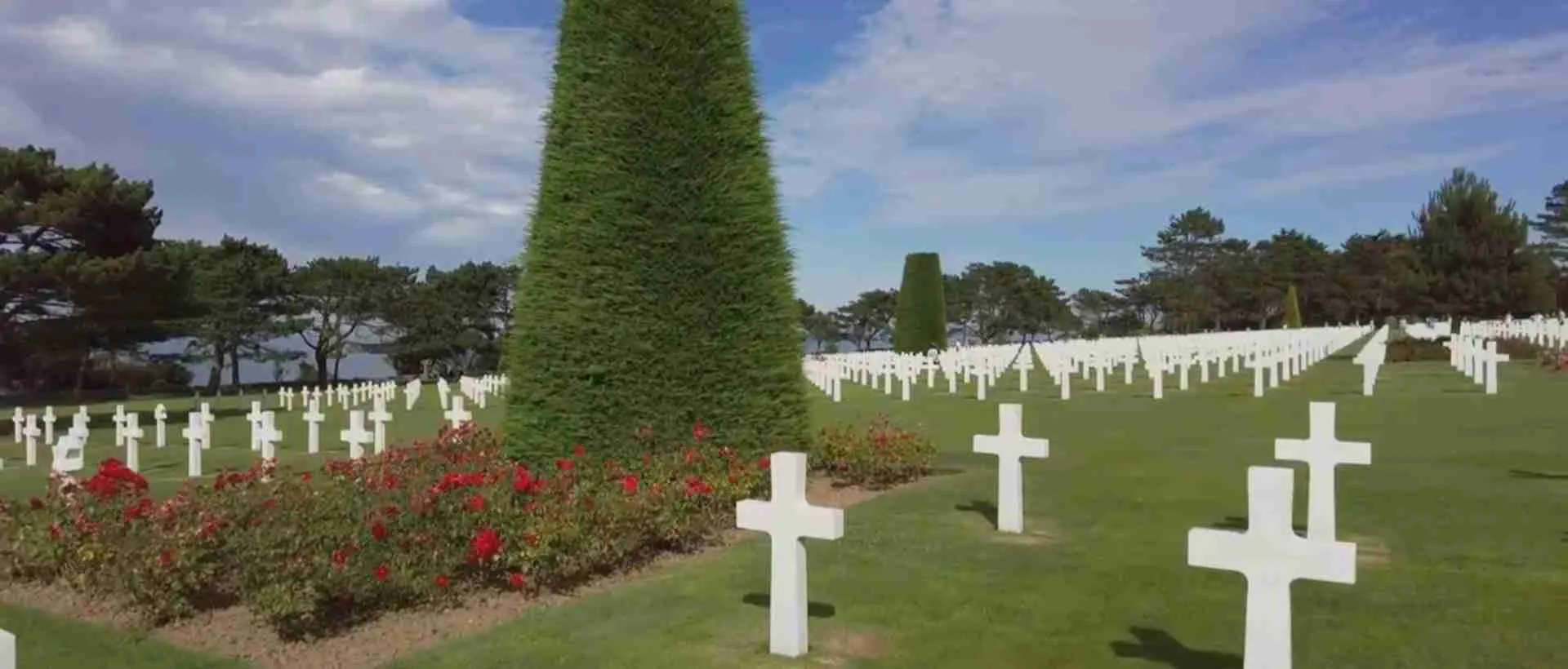
- The landing site connects directly to Normandy American Cemetery, creating a comprehensive historical experience
- Preserved battlefield elements include German defensive positions, memorial monuments, and interpretive markers throughout the beach area
Introduction: America’s Most Challenging D-Day Battlefield
Omaha Beach stands as the most challenging and costly of the five D-Day landing beaches, where American forces fought through withering German fire to secure a vital foothold in Nazi-occupied France. The 6-kilometer stretch of Normandy coastline between the villages of Vierville-sur-Mer and Colleville-sur-Mer became the scene of desperate combat on June 6, 1944, when soldiers from the 1st and 29th Infantry Divisions faced unexpectedly strong German defenses.
The beach earned its tragic reputation through a combination of factors that created the perfect storm for American casualties. German forces had transformed the naturally defensible terrain into a sophisticated killing zone, with bunkers, artillery positions, and machine gun nests positioned to deliver overlapping fields of fire across the tidal flats and shingle. Intelligence failures meant American commanders underestimated both the strength of German positions and the combat readiness of the defending 352nd Infantry Division.
Today, Omaha Beach serves as both memorial landscape and educational site, preserving the physical evidence of D-Day combat while honoring the soldiers who fought there. Visitors walk the same beach where Company A of the 116th Infantry Regiment suffered 96% casualties within minutes of landing, stand before German bunkers that dominated the American approach routes, and contemplate the strategic decisions that shaped the battle’s outcome. The beach connects seamlessly with the Normandy American Cemetery, creating a powerful historical narrative that extends from the landing zones to the final resting place of those who never left France.
Understanding Omaha Beach requires engaging with both its tactical complexity and human cost. The landing site offers concrete evidence of military engineering, strategic planning, and individual courage under fire. From the remnants of WN62 strongpoint where German defenders inflicted devastating casualties, to the bluffs where American soldiers fought their way inland, every element of the landscape tells part of the D-Day story. This guide explores the historical significance, battlefield geography, memorial sites, and preserved defenses that make Omaha Beach essential for understanding the Normandy invasion and the price of Allied victory in World War II.
People Also Ask About Omaha Beach
Why was Omaha Beach the deadliest D-Day landing?
Omaha Beach became the deadliest D-Day landing through the convergence of multiple tactical disadvantages that American forces could not overcome quickly. The German 352nd Infantry Division, positioned along the bluffs rather than the expected second-rate coastal defense unit, created a combat-ready force that Allied intelligence had failed to detect. These experienced German soldiers occupied sophisticated defensive positions built over three years, including reinforced concrete bunkers, artillery casemates, and interconnected trenches that provided protected movement and overlapping fields of fire.
The natural geography favored defenders dramatically. Steep bluffs rising 30 to 50 meters provided elevated positions with clear sight lines across the entire beach. Four draws, or valleys cutting through the bluffs at Vierville, Les Moulins, Colleville, and Saint-Laurent, represented the only exits from the beach, and German forces had fortified each draw with concentrated defenses. The tidal range exposed 300 meters of open sand during low tide, creating a kill zone where American soldiers had no cover while crossing to the shingle embankment.
Tactical failures compounded these challenges. Rough seas caused most amphibious tanks to sink before reaching shore, depriving infantry of crucial fire support. Naval and aerial bombardment largely missed German positions hidden in concrete bunkers. Landing craft released soldiers in water too deep, causing drowning deaths before combat began. Units landed far from designated sectors, creating confusion and breaking up the coordinated attack plan. Engineers tasked with clearing beach obstacles suffered heavy casualties, leaving many barriers intact and channeling subsequent waves into kill zones.
The combination of strong German defenses, advantageous terrain, effective pre-sighted artillery, and American tactical setbacks created conditions where soldiers faced withering fire from the moment landing craft ramps dropped. Companies lost half their strength within minutes. Officers and NCOs fell in disproportionate numbers, disrupting command structure. The beach became choked with destroyed vehicles, casualties, and soldiers seeking any available cover. Only through extraordinary individual initiative, small-unit actions, and sustained reinforcement did American forces eventually overcome German positions and push inland, but the cost in lives and suffering made Omaha the defining image of D-Day combat.
What happened at Omaha Beach on D-Day?
The battle for Omaha Beach unfolded as a near-catastrophic struggle that came closest among all D-Day landings to outright failure. American forces faced immediate disaster when the first assault waves hit the beach at 6:30 AM. Soldiers from the 116th Infantry Regiment’s Company A landed in their designated sector at Vierville and encountered devastating German fire from WN72 and WN73 strongpoints. Within ten minutes, the company suffered 96% casualties, with only a handful of men reaching the shingle embankment alive. Similar scenes played out across all five landing sectors as German defenders, protected in concrete positions and largely untouched by naval bombardment, opened fire on exposed American troops.
The early hours saw complete breakdown of the assault plan. Amphibious DD tanks, designed to provide covering fire, sank in rough seas or arrived late and ineffective. Combat engineers attempting to clear beach obstacles became primary targets and suffered catastrophic losses, leaving mines and barriers intact. Landing craft coxswains, unable to see through smoke and facing heavy fire, dropped troops far from designated beaches, scattering units and disrupting coordination. By 8:30 AM, beach conditions deteriorated to crisis levels, with subsequent landing waves pushing into sectors already choked with casualties, destroyed equipment, and immobilized soldiers.
The turning point came through small-unit actions rather than coordinated assault. Groups of soldiers, often led by junior officers and NCOs after senior commanders fell, began working up the bluffs between the heavily defended draws. These infiltration groups attacked German positions from flanks and rear, gradually reducing strongpoints that had pinned down troops on the beach. Destroyers moved dangerously close to shore, providing direct fire support against specific German bunkers. By noon, enough American forces had penetrated inland to threaten German defensive coherence, though fighting continued throughout the day.
The battle resulted in over 2,000 American casualties, with exact numbers remaining uncertain due to the chaos of combat. Units achieved only fraction of D-Day objectives, penetrating roughly 1.5 kilometers inland rather than the planned link-up with British forces to the east. The shallow beachhead remained vulnerable to counterattack, though German forces lacked reserves to exploit American weakness. By nightfall, approximately 34,000 troops had landed, establishing precarious foothold that would expand in subsequent days. The near-failure at Omaha Beach demonstrated both the extreme difficulty of amphibious assault against prepared defenses and the resilience of American soldiers who, despite catastrophic losses and tactical setbacks, refused to accept defeat and ultimately secured the beach through individual courage and determination.
What can you see at Omaha Beach today?
Omaha Beach preserves extensive physical evidence of D-Day combat, offering visitors tangible connections to the battle through preserved German defenses, memorial monuments, and interpretive sites that span the 6-kilometer landing area. The beach itself remains largely as it appeared in 1944, with the same tidal flats, shingle embankment, and imposing bluffs that American soldiers faced. Walking the beach during low tide reveals the 300-meter expanse of exposed sand that troops crossed under fire, while the draws at Vierville, Les Moulins, Colleville, and Saint-Laurent still mark the only natural exits from the beach.
German defensive positions represent the most dramatic preserved elements. WN62 strongpoint above the Les Moulins draw remains the best-preserved German position, with concrete observation bunkers, personnel shelters, and weapon positions intact. This position inflicted devastating casualties on American forces and offers clear demonstration of German defensive strategy, including overlapping fields of fire and protected movement between positions. WN72 at Vierville preserves a massive H677 casemate designed for 88mm guns, showing the scale of German engineering. Numerous smaller bunkers, tobruks (circular machine gun positions), and trenches dot the bluffs, many accessible to visitors who can experience the defender’s perspective on the battlefield.
Memorial monuments mark key locations and honor specific units. The Big Red One monument at Colleville commemorates the 1st Infantry Division’s landing. The National Guard Monument at Les Moulins recognizes the 29th Infantry Division’s sacrifice. Signal Monument near Saint-Laurent marks where American forces first breached German defenses. Each draws features monuments explaining the tactical situation and honoring units that fought there. Interpretive panels throughout the beach provide historical context, tactical maps, and photographs connecting present landscape to past battle.
The Omaha Beach Memorial Museum at Saint-Laurent provides comprehensive battle narrative through artifacts, personal items, weapons, and large-format photographs. The collection includes German defensive equipment, American landing craft components, and detailed dioramas showing beach obstacles and defensive positions. A short distance inland, the Normandy American Cemetery creates the emotional culmination of any Omaha Beach visit, where 9,388 American soldiers rest on bluffs overlooking the landing beaches. Visitors can follow marked routes connecting beach landing sites with specific grave locations, understanding the complete arc from combat to commemoration. The preservation of bunkers, memorials, museums, and cemetery creates comprehensive historical landscape where the scale, complexity, and human cost of the Omaha Beach landing become powerfully apparent.
How long does it take to visit Omaha Beach?
A thorough visit to Omaha Beach requires 4 to 6 hours to properly explore the beach, preserved defenses, memorials, and museum while understanding the tactical geography. The extended timeline reflects both the 6-kilometer length of the landing area and the depth of historical interpretation available at multiple sites. Visitors who walk significant portions of the beach, climb to German bunker positions, and engage with interpretive materials need substantially more time than those making brief memorial stops.
The minimum meaningful visit lasts 2 to 3 hours, focusing on one or two specific landing sectors rather than attempting comprehensive coverage. This timeframe allows walking a section of beach to understand the distance troops crossed under fire, visiting one major German strongpoint like WN62 to see defensive positions, and spending time at sector-specific memorials and interpretive panels. The Omaha Beach Memorial Museum adds 60 to 90 minutes to any visit, with comprehensive exhibits requiring patient examination of artifacts, photographs, and tactical displays.
Comprehensive exploration spanning the entire beach requires full-day commitment of 6 to 8 hours. This approach includes walking or driving the beach road from Vierville to Colleville, stopping at each of the four draws to understand different tactical situations. Climbing to multiple German bunker positions, particularly WN62 and WN72, provides defender perspectives across the beach. Reading interpretive panels at memorial sites, examining preserved obstacles and defenses, and contemplating the tactical challenges from both American and German viewpoints demands time and physical effort, as many positions require hiking up steep bluff trails.
Combining Omaha Beach with Normandy American Cemetery creates a 6 to 8 hour experience that connects battlefield to final resting place. The cemetery, located on bluffs above Colleville-sur-Mer, requires 90 minutes to 2 hours for meaningful visit, including the visitor center with D-Day timeline, memorial chapel, and time among the graves. Many visitors find this combination essential for complete emotional and intellectual understanding of Omaha Beach, as the cemetery provides names and faces to the tactical narrative told on the beach below. The physical proximity makes this pairing natural and powerful, with the beach visible from cemetery grounds, creating spatial connection between combat site and commemoration.
Extended multi-day tours – 5+ days
Featured Normandy Multi-Day Tour Packages

3 days
Brittany and Normandy
- ✓ Comprehensive Normandy tour
- ✓ Expert local guides included
- ✓ All accommodation arranged
- ✓ Transportation provided

8 days
Journeys: Paris & Normandy Highlights National Geographic
- ✓ Comprehensive Normandy tour
- ✓ Expert local guides included
- ✓ All accommodation arranged
- ✓ Transportation provided
5 days
WWII D-Day Landing Beaches & Battle of Normandy
- ✓ Comprehensive Normandy tour
- ✓ Expert local guides included
- ✓ All accommodation arranged
- ✓ Transportation provided

8 days
Seine Experience Normandy 2027
- ✓ Comprehensive Normandy tour
- ✓ Expert local guides included
- ✓ All accommodation arranged
- ✓ Transportation provided
Multi-day tour packages powered by TourRadar. Prices and availability subject to change.
Historical Background: The Bloodiest Beach
Omaha Beach entered D-Day planning as the critical link between British landing beaches to the east and American landings at Utah Beach to the west. Allied planners designated the 6-kilometer stretch between the Vire Estuary and Port-en-Bessin for American V Corps assault, with 1st Infantry Division and 29th Infantry Division assigned to capture the beach and push inland to link with British forces advancing from Gold Beach. The selection of Omaha reflected both geographic necessity and strategic calculation, as the beach provided the only suitable landing area along this portion of the Normandy coast, despite obvious defensive advantages for German forces.
German defensive preparation transformed Omaha from challenging terrain into formidable fortress. Beginning in 1942, the German military constructed the Atlantic Wall, Hitler’s ambitious coastal defense system stretching from Norway to Spain. Omaha received intensive fortification attention due to its obvious invasion suitability. Engineers embedded steel and concrete obstacles across tidal zones, including Belgian gates, Czech hedgehogs, and tetrahedra designed to rip open landing craft. They built reinforced concrete bunkers and casemates for artillery, anti-tank guns, and machine guns, positioning these weapons to create interlocking fields of fire across the beach. Trenches connected positions, allowing protected German movement. Minefields covered approaches. Every natural feature received defensive enhancement, turning the four draws into kill zones protected by concentrated firepower.
The 352nd Infantry Division’s presence along Omaha Beach represented the critical intelligence failure that shaped the battle’s outcome. Allied planners expected to face the 716th Static Infantry Division, a second-rate coastal defense unit composed largely of older soldiers and non-German conscripts. Instead, Field Marshal Erwin Rommel had moved the experienced 352nd Division into position along the coast in March 1944, placing combat-tested soldiers in the Omaha defenses. This division had trained specifically for beach defense, conducted regular exercises, and maintained high combat readiness. American forces discovered this deployment only when they encountered determined resistance from soldiers who knew their positions, weapons, and tactical responsibilities.
Pre-invasion bombardment failed to destroy German defenses at Omaha despite extensive air and naval preparation. On June 6, Allied aircraft dropped 13,000 bombs on the beach area before dawn, but cloud cover and concerns about hitting landing craft caused bombers to delay release, and most ordnance fell inland, leaving beach defenses intact. Naval bombardment began at 5:50 AM, with battleships, cruisers, and destroyers firing on German positions, but the short duration and difficulty hitting reinforced bunkers meant most strongpoints survived undamaged. German defenders emerged from shelters as bombardment ceased and found their weapons functional, communications intact, and clear fields of fire as American landing craft approached.
The American assault plan divided Omaha into five sectors designated Easy Green, Easy Red, Fox Green, Fox Red, and Dog sectors, with specific units assigned to each. The 116th Infantry Regiment from the 29th Infantry Division would assault the western sectors at Vierville and Les Moulins, while the 16th Infantry Regiment from the 1st Infantry Division targeted eastern sectors at Colleville and Saint-Laurent. The plan called for amphibious DD tanks to land first, providing covering fire as infantry reached the beach. Combat engineers would clear beach obstacles during low tide. Infantry would advance quickly across the beach to the shingle embankment, then push through the draws to capture villages on the coastal plateau. Subsequent waves would land vehicles, artillery, and supplies to support the push inland. The entire assault assumed that naval and air bombardment had severely damaged German defenses and that opposition would be light to moderate.
Reality shattered these assumptions within minutes of the first landings. Rough seas caused 27 of 32 DD tanks to sink, eliminating crucial fire support. Infantry landed in wrong sectors, often in deep water that drowned soldiers burdened with heavy equipment. German fire proved immediately devastating, with machine guns, mortars, and artillery striking landing craft and exposed troops. The tactical plan collapsed as units became intermixed, officers fell, and soldiers sought whatever cover they could find. By 8:30 AM, V Corps commander Major General Leonard Gerow considered halting all landings at Omaha, as the beach appeared to be failing. The crisis point had arrived, with American forces pinned down, casualties mounting, and German defenses intact and effective.
The battle’s resolution came through individual initiative rather than grand tactics. Small groups of soldiers, often led by junior officers like Colonel George Taylor who famously declared “Two kinds of people are staying on this beach: the dead and those who are going to die. Now let’s get the hell out of here,” began moving up the bluffs. These infiltrations attacked German positions from unexpected directions, gradually reducing strongpoints. Destroyers provided crucial close fire support, with ships like USS McCook moving within 800 meters of shore to engage specific bunkers. By noon, enough penetrations had occurred that German defensive coherence began breaking. American forces controlled positions on the bluffs and pushed inland, though far short of D-Day objectives. The victory came at terrible cost, with over 2,000 casualties making Omaha the bloodiest of all D-Day beaches, but American forces had secured the beach and established the foothold that would eventually link British and American forces and contribute to the liberation of France.
Strategic Significance: The Critical Link
Omaha Beach occupied the strategic centerpoint of the entire D-Day invasion, creating the essential connection between American and British landing forces. The beach’s capture prevented a potentially catastrophic gap in the Allied line that German forces could have exploited to defeat the invasion in detail, attacking isolated beachheads separately. Military planners understood that failure at Omaha would leave American forces at Utah Beach separated from British forces at Gold Beach by 30 kilometers of German-controlled coastline, enabling enemy forces to concentrate against individual beachheads and potentially driving Allied forces back into the sea.
The beach’s geographic position determined Allied operational strategy for the entire Normandy campaign. Success at Omaha enabled the link-up between British Second Army advancing east and American First Army pushing west, creating a unified beachhead 80 kilometers wide. This continuous front prevented German forces from infiltrating between Allied armies and allowed coordinated operations toward Cherbourg and Caen. The eastern edge of Omaha connected directly to Gold Beach, where British 50th Infantry Division landed, while the western sectors provided the foundation for eventual linkage with Utah Beach forces advancing from the Cotentin Peninsula.
Port-en-Bessin, located on Omaha’s eastern boundary, represented a critical logistical objective. British commandos from Gold Beach fought through June 7-8 to capture this small fishing port, which became a crucial terminal for the PLUTO pipeline (Pipeline Under The Ocean) bringing fuel from England. The port’s capture depended entirely on Omaha Beach success, as German forces could have held Port-en-Bessin indefinitely if American forces hadn’t secured the approaches from the west. The facility processed petroleum products essential for mechanized warfare throughout the Normandy campaign.
The beach’s importance extended beyond immediate tactical objectives to fundamental strategic calculations. Allied planners needed sufficient landing beaches to bring ashore the massive force required to defeat German armies in France. Eliminating Omaha from the invasion plan would have concentrated forces on fewer beaches, creating dangerous congestion and reducing operational flexibility. The Allies calculated they needed to land 150,000 troops on D-Day alone, with millions more to follow. Omaha’s 6-kilometer frontage provided essential capacity for this enormous logistical operation.
German defensive strategy recognized Omaha’s significance, which explained the extensive fortification effort. Field Marshal Rommel understood that the Allies could not succeed with disconnected beachheads and that defeating the invasion required stopping landings at the beaches or destroying isolated forces before they could link up. He concentrated defensive resources on likely landing sites, with Omaha receiving major engineering effort, troop deployments, and artillery support. The 352nd Infantry Division’s assignment to Omaha reflected German appreciation of the beach’s strategic value and their determination to hold this critical sector.
The near-failure at Omaha exposed the fundamental risk in amphibious warfare. For several hours on June 6, the entire D-Day operation teetered on the edge of disaster, with German forces coming closer to victory at Omaha than at any other beach. Had the assault failed completely, with American forces trapped on the beach or driven back to their ships, the consequences would have extended far beyond a single tactical defeat. The invasion might have been delayed months or years, with incalculable impact on the war’s outcome. The ultimate success at Omaha, despite catastrophic casualties and tactical setbacks, validated the strategic risk Allied planners had accepted and created the conditions for eventual victory in France.
Battlefield Geography: Natural Defensive Terrain
Omaha Beach’s physical geography created natural advantages for defenders that German forces enhanced through engineering, resulting in the most challenging terrain among all D-Day landing beaches. The beach stretches 6 kilometers between Sainte-Honorine-des-Pertes in the east and Vierville-sur-Mer in the west, with steep bluffs rising 30 to 50 meters along the entire length. This vertical terrain feature forced attackers to cross open beach under observation and fire from elevated positions, creating the fundamental tactical challenge American forces faced on June 6, 1944.
The tidal zone at Omaha exposes 300 meters of sand during low tide, expanding to 400 meters in some sectors. Allied planners scheduled landings for low tide to expose German beach obstacles, allowing engineers to clear paths through the defenses. This decision, while tactically sound for obstacle clearance, created maximum exposure for infantry crossing open sand. Soldiers left landing craft in water still chest-deep, then faced a 200 to 300-meter advance across flat sand with no natural cover before reaching the shingle embankment, a 3-meter-high bank of small stones that provided the first protected position. Every meter of this approach remained visible to German defenders positioned on the bluffs above.
Four draws, or natural valleys, cut through the bluffs at Vierville (D-1), Les Moulins (D-3), Colleville (E-1), and Saint-Laurent (E-3), providing the only vehicle exits from the beach. These draws became focal points for both American assault plans and German defensive efforts. Each draw featured paved or dirt roads climbing through the bluffs to villages on the coastal plateau, essential for moving vehicles, artillery, and supplies inland. German forces recognized this tactical reality and fortified each draw with concentrated defenses, including anti-tank walls, minefields, barbed wire, and heavy weapons positions. The draws became natural kill zones where German fire converged on American forces attempting to break out from the beach.
The bluffs themselves varied in steepness and accessibility along the beach length. Western sectors near Vierville featured nearly vertical clay cliffs up to 50 meters high, virtually impassable except through the draw. Eastern sectors near Colleville showed more gradual slopes in places, with gullies and ravines offering potential infiltration routes for determined soldiers. These geographic variations influenced the battle’s development, as small groups of Americans discovered that climbing between the defended draws, while difficult and dangerous, offered opportunities to attack German positions from unexpected directions. The bluffs’ height provided German defenders with panoramic views of the entire beach and approaching landing craft, allowing artillery observers to direct fire with precision.
Beach composition affected mobility significantly. The shingle embankment created an obstacle that wheeled vehicles could not cross, trapping tanks, trucks, and artillery on the tidal flats where they became targets for German guns. The sand itself, while firm when wet, became soft and difficult for heavily loaded soldiers to traverse quickly. Engineers attempting to clear beach obstacles worked in sand that shifted underfoot while German fire fell around them. The combination of soft sand, steep shingle bank, and 300-meter approach distance meant that soldiers needed 5 to 10 minutes of continuous movement to reach any protected position, an eternity under fire.
Seasonal weather patterns complicated the already challenging terrain. June 6 featured stronger winds and higher seas than planners anticipated, with waves reaching 1 to 2 meters. These conditions caused landing craft to drift off course, contributed to DD tank losses, and made the approach to beach more difficult. Soldiers seasick from the rough channel crossing faced the immediate challenge of crossing the beach under fire. Weather also affected visibility, with smoke from naval bombardment and grass fires obscuring German observation in some sectors while providing cover for American movements in others.
The coastal plateau above the bluffs featured dense hedgerow country characteristic of Norman bocage, creating defensive terrain that favored German forces even after American troops penetrated inland. The combination of beach obstacles, tidal exposure, bluff heights, limited exit routes, and challenging inland terrain created layered defenses that multiplied the difficulty of the amphibious assault. This geography, enhanced by German engineering and defended by combat-ready troops, produced the catastrophic casualties and near-failure that defined the Omaha Beach landing and demonstrated the extreme difficulty of opposed amphibious warfare against prepared defenses on naturally advantageous terrain.
German Defensive System: Atlantic Wall Engineering
The German defensive system at Omaha Beach represented sophisticated military engineering designed to destroy amphibious assaults before they could establish footholds. Construction began in 1942 as part of Hitler’s Atlantic Wall program, with intensive building continuing through early 1944. The defenses combined beach obstacles, reinforced concrete positions, interconnected trenches, and pre-sighted artillery to create overlapping layers of firepower that covered every approach to the beach and all possible exit routes.
Beach obstacles formed the first defensive layer, positioned across tidal zones to damage or destroy landing craft. German engineers installed three lines of obstacles at different tidal levels, ensuring that approaching boats faced barriers regardless of sea state. Belgian gates, heavy steel frames 3 meters high, created massive obstacles topped with mines that would detonate against landing craft hulls. Czech hedgehogs, welded steel beams arranged in tripod configurations, punctured boat bottoms and blocked vehicle movement. Tetrahedra, concrete pyramids faced with steel, provided stable obstacles that landing craft could neither push aside nor climb over. Wooden stakes driven into the sand supported teller mines at heights calculated to strike landing craft. Engineers placed these obstacles in patterns that channeled boats toward killing zones covered by concentrated fire.
Concrete strongpoints, designated with “WN” (Widerstandsnest or resistance nest) numbers, dominated the tactical landscape. Fifteen major strongpoints studded the bluffs above Omaha, each positioned to create interlocking fields of fire with neighboring positions. WN62 above Easy Red and Fox Green sectors became the most lethal position, with observation bunkers providing panoramic views, personnel shelters protecting German soldiers from bombardment, and weapon positions housing machine guns, mortars, and anti-tank guns. The strongpoint’s central location allowed defenders to fire along the beach in both directions while also covering approaches to Colleville draw. Engineers built positions from reinforced concrete up to 2 meters thick, creating structures that naval guns and aerial bombs could not destroy.
Artillery casemates housed larger weapons in protected positions. The H677 casemate at WN72 near Vierville contained an 88mm gun capable of engaging ships, landing craft, and armored vehicles. Similar positions throughout the defensive belt mounted 75mm and 50mm guns, anti-tank weapons, and mortars. These positions featured thick concrete walls and roofs with narrow embrasures limiting exposure while allowing wide fields of fire. Gun crews inside remained protected from naval bombardment and small arms fire, emerging only when targets presented themselves. The Germans pre-sighted all weapons on specific beach sectors, creating a comprehensive fire plan that required minimal adjustment during actual combat.
Machine gun positions provided the volume of fire that proved most devastating to American infantry. Tobruks, circular concrete positions topped with steel cupolas, housed MG42 machine guns firing 1,200 rounds per minute. Germans positioned these weapons to create crossfire across the beach, ensuring that soldiers advancing from the waterline faced converging streams of bullets regardless of their route. The MG42’s sustained fire rate and accuracy at ranges up to 1,000 meters meant single guns could suppress entire companies. Multiple tobruks within each strongpoint created redundant firing positions, so that destruction of one weapon barely reduced defensive capability.
Trench systems connected defensive positions, allowing German soldiers to move between locations without exposure to fire. These communication trenches featured dugouts for shelter, ammunition storage areas, and alternate firing positions. The interconnected nature of the defenses meant that American forces could not neutralize strongpoints simply by destroying obvious bunkers, as defenders could shift to alternate positions and continue fighting. The trenches also provided fallback routes, allowing Germans to retreat inland while maintaining organized resistance.
Minefields covered approaches to defensive positions and areas between strongpoints. Anti-personnel mines inflicted casualties on advancing infantry, while anti-tank mines threatened armored vehicles attempting to move inland. Wire obstacles, including barbed wire entanglements and concertina wire, channeled movement into kill zones and slowed attackers. German engineers had studied the terrain carefully, identifying likely infiltration routes and closing them with mines and wire.
The defensive system’s depth extended beyond the immediate beach area. Artillery batteries positioned 2 to 4 kilometers inland provided indirect fire support, targeting the beach and approach channels based on forward observer directions from strongpoints. These guns could engage landing craft offshore, bombard the beach itself, and interdict routes inland. The combination of direct fire weapons at strongpoints and indirect artillery created a comprehensive defensive web that covered the entire operational area.
Command and control infrastructure ensured defensive coherence. Telephone lines connected strongpoints to battalion and regiment headquarters, allowing rapid communication and coordination. Observation posts equipped with range-finding equipment provided precise targeting data. Ammunition resupply routes ensured defenders could maintain fire rates during extended combat. The Germans had tested the system through exercises, identifying weaknesses and refining procedures.
This defensive architecture proved devastatingly effective on June 6, 1944. The bunkers survived bombardment intact. Beach obstacles damaged numerous landing craft and forced others into kill zones. Machine guns and artillery created such intense fire that American forces could not execute their assault plan. The engineering excellence that went into the Atlantic Wall defenses at Omaha Beach nearly achieved the German goal of destroying the invasion at the waterline, and only extraordinary courage and determination by American soldiers eventually overcame these formidable positions.
American Forces: The Big Red One and Blue and Gray
Two American infantry divisions carried the assault at Omaha Beach: the 1st Infantry Division, known as the Big Red One, and the 29th Infantry Division, called the Blue and Gray. These units represented different military traditions but shared the mission of securing the bloodiest D-Day landing beach. The combination of veteran combat soldiers and National Guard troops created a force that would demonstrate both the difficulty of the Omaha assault and the resilience of American infantry.
The 1st Infantry Division brought extensive combat experience to Omaha Beach, having fought in North Africa, Sicily, and mainland Italy before the Normandy invasion. The division earned its Big Red One nickname from the shoulder patch featuring a red numeral one on an olive drab background, reflecting its designation as the U.S. Army’s oldest active division. Soldiers from the 1st had participated in the amphibious landings at Oran, Gela, and Salerno, giving them practical knowledge of beach assaults under fire. This experience, while valuable, could not fully prepare them for the intensity of defensive fire at Omaha.
The 16th Infantry Regiment from the 1st Division received responsibility for the eastern sectors of Omaha Beach, including Fox Green, Easy Red, and parts of Easy Green. The regiment’s three battalions organized into assault waves, with Company E of the 16th landing in the first wave at 6:30 AM. These soldiers faced immediate catastrophic fire from WN62 and neighboring strongpoints. Company E’s experience mirrored that of units across Omaha, with soldiers cut down crossing the beach, equipment lost in deep water, and tactical plans dissolving under German fire. The regiment’s combat experience helped survivors maintain cohesion and continue fighting despite enormous casualties.
The 29th Infantry Division represented the National Guard tradition, with units drawn from Virginia, Maryland, and Pennsylvania. The Blue and Gray nickname reflected the division’s composition from states that fought on opposite sides during the Civil War. Unlike the 1st Division, the 29th had not seen combat before D-Day. Soldiers trained extensively in amphibious operations in England, including rehearsals on beaches similar to Omaha, but they lacked the combat experience that might have prepared them psychologically for the intensity of German fire. This inexperience showed in the initial confusion and high casualties, but the division’s performance demonstrated that training and determination could overcome the shock of first combat.
The 116th Infantry Regiment from the 29th Division assaulted the western sectors of Omaha, including Dog White, Dog Green, Dog Red, and Easy Green. Company A of the 116th landed at Vierville draw and suffered the worst casualties of any American unit on D-Day, with 96% of the company killed, wounded, or missing within minutes of landing. Company A’s destruction became emblematic of the Omaha Beach disaster, with German fire from WN72 and WN73 converging on soldiers as they left landing craft. The few survivors spent hours pinned against the shingle embankment, unable to advance or retreat, watching subsequent waves land into the same kill zone.
Supporting elements attached to both divisions played crucial roles despite heavy casualties. The 741st Tank Battalion provided DD amphibious tanks for the 1st Division sectors, but rough seas caused 27 of 29 tanks to sink before reaching shore, depriving infantry of essential fire support. The 743rd Tank Battalion supporting the 29th Division made the controversial decision to bring tanks directly onto beach in landing craft rather than launching offshore, resulting in 14 tanks reaching the beach and providing some covering fire. Combat engineers from the 146th and 299th Engineer Combat Battalions attempted to clear beach obstacles under withering fire, suffering 41% casualties while managing to clear only six of sixteen planned gaps through obstacles.
Ranger companies attached to the 29th Division assault brought special operations capability to Omaha Beach. Companies A, B, and C of the 2nd Ranger Battalion landed at Vierville to support the 116th Infantry, with Company C assigned to assault Pointe du Hoc if circumstances permitted. The Rangers brought specialized training in cliff assault and point attacks, skills that proved valuable when American forces began infiltrating up the bluffs between defended draws. Their combat experience and aggressive tactics contributed to the small-unit actions that eventually cracked German defenses.
Artillery battalions planned to land shortly after initial assault waves to provide fire support, but beach congestion and German fire delayed most artillery until late afternoon. The 111th Field Artillery Battalion, 7th Field Artillery Battalion, and other units suffered heavy casualties attempting to bring guns ashore, with German fire destroying vehicles and killing crews. The lack of artillery support during critical morning hours meant American forces fought without one of their primary advantages, forcing infantry to overcome German positions through direct assault rather than coordinated fire and maneuver.
Naval Combat Demolition Units and Army engineers tasked with clearing beach obstacles faced perhaps the most dangerous mission on Omaha Beach. These specialized teams landed with explosives to destroy Belgian gates, Czech hedgehogs, and other obstacles during the brief low-tide window. German defenders recognized the threat these teams posed and targeted them specifically. The combination of exposure, complex technical work under fire, and the need to operate near explosive charges created casualty rates exceeding 50% in some teams. Their partial success in clearing beach obstacles, despite devastating losses, allowed subsequent landing waves to reach shore and eventually contributed to the battle’s outcome.
The leadership challenged at Omaha Beach fell heavily on junior officers and NCOs after many senior commanders became casualties. Brigadier General Norman Cota, assistant division commander of the 29th Division, personally led soldiers off the beach, famously asking a group of Rangers, “What outfit is this?” When told “5th Rangers,” he replied “Well, goddammit, if you’re Rangers, get up and lead the way!” This incident led to the Ranger motto “Rangers Lead The Way.” Colonel George Taylor of the 16th Infantry rallied soldiers with his declaration about two kinds of people on the beach, galvanizing movement inland. These leadership moments, multiplied across the beach by dozens of junior leaders, transformed a near-disaster into hard-fought victory and demonstrated the critical importance of leadership at the lowest tactical levels.
The Landing: First Waves at Dawn
The first assault wave approached Omaha Beach at 6:30 AM on June 6, 1944, with soldiers from the 116th Infantry Regiment and 16th Infantry Regiment packed into landing craft crossing 12 miles of English Channel in rough seas. Most soldiers spent 3 to 4 hours in cramped, exposed boats, suffering from seasickness and soaked by spray. The sight of the Normandy coast emerging from morning mist brought both relief at ending the miserable crossing and apprehension about the coming assault. Naval bombardment continued until 6:25 AM, with shells screaming overhead and explosions visible along the bluffs, creating the impression that German defenses were being systematically destroyed. This impression proved tragically wrong.
Landing Craft Vehicle Personnel (LCVP), the standard Higgins boats carrying 30 soldiers each, closed the final distance to shore at 6:28 AM, with coxswains attempting to beach craft according to plans that designated specific landing sectors for each unit. Reality immediately diverged from planning. Tidal currents, smoke obscuring landmarks, and coxswain decisions to avoid visible obstacles resulted in boats landing hundreds of meters from intended sectors. This drift destroyed unit cohesion, as companies and platoons scattered across the beach rather than landing in organized formations. The first indication of trouble came when boat ramps dropped and soldiers faced water chest-deep or deeper, forcing them to wade toward shore while burdened with 60 to 80 pounds of equipment.
German fire erupted the instant landing craft ramps dropped, with machine guns targeting the boat exits specifically. Soldiers at the front of landing craft, typically officers and NCOs leading their units, fell immediately. Others plunged into water too deep and drowned, dragged under by heavy equipment. Those reaching shoulder-deep water struggled toward shore, moving in slow motion while bullets struck around them. Some soldiers discarded equipment to avoid drowning, losing weapons, ammunition, and radios essential for combat. The 300-meter wade to the shingle embankment, theoretically a 5-minute movement, became a terrifying ordeal lasting 20 minutes or more, with soldiers presenting perfect targets for German gunners positioned on the bluffs.
Company A of the 116th Infantry Regiment experienced the worst first-wave casualties, landing directly in front of WN72 strongpoint at Vierville. The company’s six landing craft approached the beach in line, presenting a concentrated target for German defenders who had pre-sighted their weapons on this exact sector. Machine gun fire and artillery converged on the landing craft and the soldiers attempting to reach shore. Within ten minutes, the company ceased to exist as an organized unit, with officers dead, most soldiers killed or wounded, and the few survivors pinned against the shingle, unable to advance or help the wounded. Company A’s destruction set the pattern for the first hour of battle, demonstrating the effectiveness of German defenses and the failure of pre-invasion bombardment to neutralize strongpoints.
The few DD amphibious tanks that reached shore provided limited support but could not significantly change the tactical situation. Most tanks from the 741st Tank Battalion sank in rough seas, leaving infantry without the covering fire they desperately needed. The 743rd Tank Battalion’s decision to bring tanks directly onto the beach in landing craft resulted in several tanks reaching shore, but German anti-tank guns quickly engaged them. Some tanks bogged down in soft sand, others took direct hits from German guns, and the survivors could only provide limited support while dealing with their own survival. The promised armor support that should have suppressed German positions and allowed infantry to advance largely failed to materialize.
Combat engineers attempting to clear beach obstacles faced impossible conditions. The 146th Engineer Combat Battalion landed in the first waves with the mission of blowing 16 gaps through beach obstacles during the low-tide window. Engineers worked in teams, placing explosive charges on Belgian gates and Czech hedgehogs while German fire killed and wounded team members. Landing craft attempting to avoid obstacles channeled into lanes that became killing zones. The engineers’ casualties exceeded 40% in the first thirty minutes, with surviving teams unable to complete their mission. The failure to clear sufficient obstacle gaps meant subsequent landing waves faced the same threats, with boats striking mines, ramming obstacles, or landing in sectors already choked with casualties and destroyed equipment.
The tactical situation deteriorated rapidly as the first hour progressed. Units landed in wrong sectors, separated from their commanders and supporting units. Officers and NCOs fell in disproportionate numbers, creating leadership vacuum. Soldiers reaching the shingle embankment found minimal cover from direct fire but some protection from artillery. The beach behind the shingle became a scene of carnage, with wounded men calling for medics, destroyed vehicles burning, and equipment scattered across the sand. German defenders, protected in concrete bunkers and largely unharmed by bombardment, maintained disciplined fire on every visible target. By 7:00 AM, the assault appeared to be failing, with American forces unable to penetrate beyond the beach and casualties mounting with each additional landing wave.
Second and third wave landing craft approached beaches already under intense fire at 7:00 and 7:30 AM. Coxswains saw the catastrophic situation ahead, with burning vehicles, wounded soldiers, and obvious German fire, but orders required them to continue. Some coxswains dropped ramps early, forcing soldiers to wade even longer distances. Others pushed directly onto beach, delivering troops into sectors already saturated with casualties. The 29th Division’s 115th Infantry Regiment and additional battalions from the 16th Infantry Regiment added thousands more soldiers to the nightmare, but weight of numbers alone could not overcome German defensive positions. The beach became so congested with men, vehicles, and equipment that subsequent waves had difficulty finding space to land, creating dangerous concentrations of troops that German artillery targeted effectively.
Naval support attempted to compensate for the lack of effective pre-invasion bombardment. Destroyers moved dangerously close to shore, with ships like USS McCook, USS Carmick, and USS Doyle approaching within 800 meters to engage specific German bunkers with direct fire. This close-range naval gunfire proved more effective than earlier bombardment, destroying or suppressing some strongpoints, but the destroyers could not engage all positions simultaneously, and German defenders quickly resumed fire once naval guns shifted to other targets. The naval support provided crucial assistance but could not substitute for successful assault by infantry who remained pinned on the beach.
By 8:30 AM, the Omaha Beach assault teetered on the edge of complete failure. V Corps commander Major General Leonard Gerow considered halting all further landings, as continuing to pour troops onto a beach where they could not advance appeared to be simply feeding soldiers into a meat grinder. The crisis point had arrived, with American forces unable to execute any part of their tactical plan and German defenses proving far more formidable than intelligence estimates suggested. The next few hours would determine whether Omaha Beach became an isolated disaster that jeopardized the entire D-Day operation or whether American forces could overcome the catastrophic start and achieve their objectives through sheer determination and individual courage.
Crisis and Breakthrough: Small Unit Actions
The transformation of disaster into hard-fought victory at Omaha Beach came through small-unit actions rather than grand tactical maneuvers, as groups of soldiers began infiltrating up the bluffs between the heavily defended draws. This movement started spontaneously around 7:30 AM when junior officers and NCOs, recognizing that remaining pinned on the beach meant certain death, began leading handfuls of men toward the heights. These infiltrations exploited a fundamental flaw in the German defensive system: while strongpoints commanded the draws and beach frontage, gaps existed between positions, particularly in areas where the bluffs appeared too steep for assault.
Bangalore torpedoes proved essential for breaching wire obstacles blocking bluff approaches. Engineers and infantry worked together to assemble the explosive-filled tubes and push them under wire entanglements, blasting gaps that allowed movement inland. This technical solution to a tactical problem, repeated dozens of times across different sectors, created penetration routes that German defenders could not immediately close. Soldiers moving through bangalore gaps faced mines, small arms fire from defensive positions, and the physical challenge of climbing steep slopes under load, but movement itself, even slow and dangerous movement, represented progress after hours of stagnation on the beach.
The infiltration up the bluff west of Les Moulins draw became one of the critical breakthroughs. Colonel George Taylor, commander of the 16th Infantry Regiment, organized groups of soldiers from multiple units who had become intermingled during the chaotic landings. His famous declaration “Two kinds of people are staying on this beach, the dead and those who are going to die, now let’s get the hell out of here” galvanized movement. Taylor’s force moved up a steep ravine west of the main draw, bypassing WN62’s direct fire. German defenders, focused on the beach and draw, initially failed to notice the infiltration until American soldiers appeared on the bluffs threatening positions from flanks and rear.
Brigadier General Norman Cota’s leadership at Vierville proved equally crucial. Finding the 116th Infantry Regiment pinned down and suffering heavy casualties, Cota personally led soldiers through the wire at the base of the bluffs, then directed bangalore demolition to clear a path. His presence and example inspired movement when tactical situation appeared hopeless. Cota organized mixed groups of infantry and Rangers to attack the heavily defended Vierville draw from higher ground, approaching German positions through trenches and dead ground. This flanking movement eventually reduced WN72 and WN73, though fighting continued through the afternoon.
Destroyer fire support became increasingly effective as forward observers established positions on the bluffs and could direct naval guns against specific German bunkers. USS McCook engaged WN60 east of Colleville, destroying concrete positions with 5-inch guns fired at point-blank range. USS Carmick and USS Frankford supported infantry movements by suppressing German positions that threatened advancing soldiers. The destroyers’ willingness to operate in shallow water, risking grounding or mine strikes, provided the heavy firepower that American forces lacked due to the failure to land artillery. This naval support proved decisive in numerous small-unit actions where concentrated fire suppressed German defenders long enough for infantry to close and assault positions.
The reduction of WN62, the most lethal German strongpoint, required hours of close combat. American soldiers approached from multiple directions, attacking trenches, bunkers, and weapon positions individually. Flamethrowers proved effective against personnel shelters and machine gun positions. Grenades cleared trenches. Rifle fire suppressed German soldiers attempting to man weapons. The fighting demonstrated the tactical effectiveness of German defenses, as small numbers of defenders in prepared positions held off much larger American forces for extended periods. WN62 finally fell around 1:00 PM, not through overwhelming assault but through persistent pressure from multiple directions that eventually isolated and destroyed individual defensive elements.
Communication breakdown both hindered and helped American forces. The destruction of radios during landings meant higher headquarters had minimal information about tactical situations and could not provide coordinated support or direction. This isolation forced small-unit leaders to make independent decisions based on immediate circumstances rather than higher-level planning. The absence of communication also meant units could not be ordered to halt or pull back, and junior leaders took risks that more senior commanders might have prevented. The initiative shown by junior officers and NCOs, making tactical decisions and leading soldiers forward despite enormous casualties, proved essential to achieving breakthrough when overall assault plan had collapsed.
By noon, enough American penetrations had occurred that German defensive coherence began breaking down. Forces on the bluffs could attack strongpoints from unexpected directions. Units pushing inland threatened German rear areas and communication lines. The defenders, while still fighting effectively in many positions, could no longer maintain the comprehensive defensive web that had made the beach such a killing zone. German battalion and regimental commanders, lacking reserves and unable to coordinate counterattacks, watched their defensive system fracture under persistent American pressure.
The afternoon saw continued fighting as American forces expanded penetrations and pushed toward D-Day objectives, though they fell far short of planned advances. Units from the 1st Division captured Colleville around 3:00 PM after house-to-house fighting. The 29th Division entered Saint-Laurent but faced continued resistance. Vierville remained contested through the evening. The draws that had been primary assault objectives in the morning became secondary concerns as American forces demonstrated they could bypass these strongpoints and attack from higher ground. Engineers worked to improve draw access for vehicles and supplies while fighting continued around them.
The beachhead at nightfall measured roughly 2 kilometers deep at its maximum penetration and remained vulnerable to German counterattack. American forces had achieved only fraction of D-Day objectives, with plans calling for link-up with British forces to the east and advances 10 kilometers inland. Instead, soldiers occupied a shallow toehold, still within range of German artillery, with defensive positions hastily established in hedgerow country. The narrow beachhead represented success only in comparison to the morning’s near-disaster, demonstrating that American forces had survived the crisis and established sufficient foothold to continue operations. The cost of this minimal success exceeded 2,000 casualties, making Omaha the bloodiest of all D-Day beaches and validating German defensive concepts even in defeat.
Preserved Bunkers and Strongpoints: German Defensive Heritage
The German defensive positions at Omaha Beach remain the most tangible evidence of D-Day combat, with concrete bunkers, observation posts, and weapon positions preserved along the 6-kilometer beach front. These structures demonstrate the engineering sophistication and tactical planning that made Omaha the most challenging Allied landing, while their survival despite intensive bombardment shows the effectiveness of reinforced concrete fortifications. Modern visitors can enter many positions, experiencing the defender’s perspective and understanding the nearly insurmountable challenges American forces faced.
WN62 strongpoint dominates the preserved battlefield, located on the bluff above the boundary between Easy Red and Fox Green sectors near Colleville-sur-Mer. This position inflicted devastating casualties on American forces throughout June 6 and represents the most complete surviving German defensive complex at Omaha Beach. The strongpoint preserves multiple concrete structures including H677 observation bunker with panoramic views across the beach, personnel shelters that protected German soldiers during bombardment, and weapon positions for machine guns and anti-tank guns. Visitors can walk through the interconnected trenches that linked firing positions, see the ammunition storage areas built into the bluff face, and stand in the observation bunker where German officers directed fire against landing craft and exposed American troops.
The tactical sophistication of WN62 becomes apparent through examination of firing positions. Machine gun tobruks positioned to create crossfire across the beach demonstrate how German defenders could engage targets from multiple angles simultaneously. The anti-tank gun casemate, though damaged by American forces during the battle, shows the thickness of concrete construction and the narrow firing embrasure that protected gun crews while allowing engagement of armored vehicles. The communication trenches connecting positions illustrate how defenders could shift between locations without exposure to fire, maintaining defensive effectiveness even when individual positions came under attack. Archaeological excavation and preservation work has revealed additional features including barbed wire anchor points, grenade storage niches, and periscope mounts for protected observation.
WN72 at Vierville preserves the massive H677 casemate designed for 88mm guns, one of the most impressive concrete structures surviving from D-Day. The casemate walls measure over 2 meters thick, with reinforced roof designed to withstand aerial bombs and naval shells. The gun embrasure provided wide field of fire covering the Vierville draw and beach approaches while offering minimal target for Allied bombardment. Though the 88mm gun itself has been removed, the mounting hardware and ammunition storage areas remain, showing the logistics required to maintain heavy weapons in combat. The casemate’s survival despite direct hits from naval guns demonstrates the effectiveness of German concrete construction techniques and explains why pre-invasion bombardment failed to neutralize defenses.
WN73, adjacent to WN72 at Vierville, preserves a different defensive configuration focused on infantry weapons rather than heavy guns. Multiple tobruks housed MG42 machine guns positioned to sweep the beach with interlocking fire. The circular concrete positions feature steel cupolas with vision slits, allowing machine gunners to observe while protected from small arms fire. Personnel shelters built into the hillside provided bomb-proof accommodation for the garrison during Allied bombardment. The proximity of WN72 and WN73, separated by less than 100 meters, demonstrates German defensive doctrine emphasizing mutual support between strongpoints, with each position covering the other’s blind spots and providing overlapping fields of fire.
WN60 east of Colleville shows extensive battle damage from destroyer fire, with concrete walls cracked and partially collapsed where 5-inch naval shells struck repeatedly. This destruction, in contrast to the intact preservation of other positions, illustrates both the effectiveness of close-range naval gunfire and the determination of American destroyers that closed to within 800 meters of shore to engage specific bunkers. The damaged bunker provides insight into the construction techniques Germans employed, with layers of reinforced concrete visible in broken walls, steel reinforcement bars exposed by shell impacts, and the complexity of formwork required to create the complex shapes of defensive positions.
WN66 above the Les Moulins draw preserves a fire control bunker that coordinated defensive fire across multiple sectors. The position features observation slits oriented to provide views east and west along the beach, range-finding equipment mounting points, and telephone line entry points connecting to other strongpoints. Fire control bunkers like WN66 allowed German officers to direct artillery and mortar fire, call for reinforcements, and coordinate defensive actions across the entire beach sector. The sophistication of German communications infrastructure, with buried telephone lines connecting positions, helped defenders maintain organized resistance despite Allied bombardment destroying many surface installations.
Scattered along the bluffs between major strongpoints, numerous smaller positions including personnel shelters, ammunition bunkers, and individual tobruks provide evidence of the defensive density Germans achieved. Some positions remain hidden in vegetation, discovered only through careful exploration. Others have been incorporated into memorial sites with interpretive panels explaining their function. The total number of preserved positions exceeds 30 concrete structures, with additional earthwork defenses visible in aerial photography and ground-penetrating radar surveys. This preservation represents one of the most comprehensive battlefield archaeological resources from World War II, allowing detailed study of defensive engineering and tactical deployment.
Conservation efforts face ongoing challenges from coastal erosion, vegetation growth, and structural deterioration. Several bunkers have partially collapsed as bluff erosion undermines foundations. Steel reinforcement rusting inside concrete causes spalling and cracking. The French government and preservation organizations work to stabilize threatened structures while maintaining authentic battlefield appearance. Some positions have received protective measures including drainage systems to prevent water infiltration, vegetation removal to reduce root damage, and structural reinforcement to prevent collapse. The balance between preservation and maintaining historical authenticity creates ongoing discussion about appropriate conservation techniques.
Access to preserved positions varies across the beach. WN62 and several other strongpoints welcome visitors, with paths, safety barriers, and interpretive signage. Other positions remain on private property or in dangerous condition, accessible only through organized tours with knowledgeable guides. The Omaha Beach Memorial Museum maintains information about accessible positions and offers guided tours that include entry to preserved bunkers. Photography of positions requires care regarding sun angles and seasonal vegetation, with spring and autumn providing clearest views of concrete structures. Winter visits offer least vegetation obstruction but can present slippery conditions on bunker access paths.
The preserved German positions at Omaha Beach provide essential context for understanding the battle’s difficulty and cost. Standing in WN62 observation bunker, looking across the beach that American soldiers crossed under fire, makes the tactical challenge viscerally clear. The concrete thickness visible in damaged bunkers explains why bombardment failed. The fields of fire from multiple positions demonstrate the comprehensive defensive web that trapped American forces. These preserved fortifications transform abstract historical accounts into concrete reality, showing exactly what American soldiers faced on June 6, 1944, and why Omaha Beach became the bloodiest of all D-Day landings.
Memorial Monuments: Honoring the Fallen
Memorial monuments scattered across Omaha Beach honor the soldiers who fought there, mark specific unit landing sites, and commemorate key moments in the battle. These memorials range from large national monuments to small plaques, each contributing to the landscape of remembrance that transforms Omaha from historical site to sacred ground. The monuments provide focal points for contemplation, education, and ceremony, connecting present visitors to past sacrifice.
The National Guard Monument at Les Moulins draw honors the 29th Infantry Division and National Guard units that assaulted the western sectors of Omaha Beach. The monument features a sculpture of a soldier advancing from the beach, rifle held high, representing the courage and determination that eventually overcame German defenses. Bronze plaques list major unit designations and provide battle narrative. The monument’s position above the draw where Company A of the 116th Infantry Regiment suffered 96% casualties creates powerful connection between memorial and battlefield, with visitors able to look down at the beach sectors where the commemorated soldiers fought and died. The National Guard Monument serves as gathering point for anniversary ceremonies, with surviving veterans, their families, and National Guard units conducting annual remembrance services.
The Big Red One Monument at Colleville-sur-Mer commemorates the 1st Infantry Division’s assault on eastern Omaha sectors. The memorial incorporates the division’s distinctive shoulder patch, the red numeral one on khaki background that gave the unit its nickname. Interpretive panels explain the 1st Division’s role in the Omaha assault, the specific sectors assigned to division units, and the casualties suffered. The monument stands near WN62 strongpoint, the German defensive position that inflicted heavy losses on 1st Division soldiers, creating geographic connection between memorial and combat site. The Big Red One Monument represents both the specific unit being honored and the broader story of veteran combat divisions brought to Normandy for the invasion.
Signal Monument near Saint-Laurent marks the location where American forces first achieved significant penetration of German defenses, breaking through the coastal defensive belt and advancing inland. The monument’s name refers to the signal sent to higher headquarters indicating the breakthrough, a message that transformed the battle’s narrative from potential disaster to hard-fought success. The simple stone memorial with bronze plaque provides limited physical presence but carries enormous historical significance, marking the geographic point where the outcome of the Omaha Beach battle shifted. Visitors standing at Signal Monument can look back toward the beach understanding that American soldiers reached this location through hours of desperate fighting, then turned and pushed further inland despite remaining German resistance.
The 5th Engineer Special Brigade Monument honors the combat engineers who cleared beach obstacles under withering fire, a mission that resulted in 41% casualties while achieving only partial success. The memorial recognizes that engineers faced perhaps the most dangerous assignment on Omaha Beach, working with explosives while exposed to German fire, attempting to clear obstacles essential for landing subsequent waves. The monument features engineer insignia and lists units that participated in obstacle clearance operations. Its location near beach access points connects memorial to work sites where engineers died clearing paths through Belgian gates, Czech hedgehogs, and mined obstacles.
Ranger Memorial at Vierville commemorates the 2nd Ranger Battalion companies that landed to support the 116th Infantry Regiment assault. The memorial specifically honors Companies A, B, and C, whose specialized training and aggressive tactics contributed to the eventual reduction of German strongpoints defending the Vierville draw. Bronze plaques explain Ranger missions on D-Day, including the planned assault on Pointe du Hoc by other companies from the same battalion. The memorial incorporates the Ranger motto “Rangers Lead The Way,” which originated at Omaha Beach when General Cota challenged Rangers to live up to their elite reputation by leading soldiers off the beach.
The 6th Engineer Special Brigade Monument marks another engineer unit’s contribution to the battle, emphasizing the critical but often overlooked role of combat engineers in amphibious operations. Engineers not only cleared obstacles but also marked safe lanes through minefields, built roads off the beach, constructed vehicle exits through the bluffs, and established traffic control points. The casualty rates among engineers approached those of assault infantry, reflecting the danger of their technical missions under fire. The memorial helps visitors understand that the Omaha Beach battle involved far more than infantry assault, requiring coordinated action by specialized units whose technical expertise proved essential to success.
Les Braves, a modern sculptural memorial installed in 2004, stands on the beach itself at Saint-Laurent, representing a contemporary artistic interpretation of D-Day sacrifice. French sculptor Anilore Banon created three distinct elements: Wings of Hope representing American soldiers, Rise of Freedom showing forces lifting themselves despite obstacles, and Wings of Fraternity honoring the alliance between French and American peoples. The abstract stainless steel sculpture creates striking visual presence against the beach landscape, offering artistic complement to traditional military monuments. Les Braves generates varied reactions from visitors, with some appreciating modern artistic expression while others prefer traditional military memorials, but the sculpture succeeds in drawing attention to the beach and prompting contemplation of D-Day’s meaning.
Individual unit monuments scattered across the beach commemorate specific regiments, battalions, and companies that landed in particular sectors. These smaller memorials often feature unit insignia, battle narrative specific to that unit’s experience, and sometimes names of soldiers who died. The concentration of memorials creates a landscape of remembrance where nearly every section of beach bears markers honoring those who fought there. This memorial density reflects the intensity of combat across the entire beach front and ensures that specific unit contributions receive recognition alongside broader national commemoration.
Maintenance and preservation of memorials falls to various organizations including the American Battle Monuments Commission, French memorial associations, unit veterans groups, and local communities. Annual ceremonies on June 6 bring dignitaries, military units, and visitors to major memorials for wreath-laying and commemoration. The gradual loss of D-Day veterans makes these ceremonies increasingly focused on education and transmission of memory to younger generations. Interpretive programs at memorial sites explain not only the historical events being commemorated but also the evolution of memorialization and the different ways societies remember sacrifice.
The relationship between memorials and battlefield landscape creates layered meaning at Omaha Beach. Standing before the National Guard Monument, visitors look down at the beach sectors where Company A suffered catastrophic casualties, connecting memorial to combat geography. The proximity of Signal Monument to WN62 strongpoint links commemoration of American success with preserved evidence of German defenses that made that success so difficult. This geographic relationship between memorials and battlefield features transforms abstract historical knowledge into concrete spatial understanding, showing exactly where commemorated events occurred and allowing visitors to comprehend the tactical situations soldiers faced. The memorials at Omaha Beach serve both as traditional monuments honoring the dead and as interpretive tools helping visitors understand the battle’s complexity and cost.
Visitor Experience: Walking the Beach
Walking Omaha Beach provides immediate physical understanding of the tactical challenges American soldiers faced on June 6, 1944. The 6-kilometer beach stretches between Vierville-sur-Mer and Colleville-sur-Mer, accessible along its entire length via the coastal road and multiple beach access points at the four draws. Visitors can walk directly on the sand, experiencing the same tidal flats that soldiers crossed under fire, though modern beach conditions differ significantly from wartime configurations with many obstacles removed and shoreline altered by decades of tidal action and storms.
The optimal tide state for battlefield comprehension occurs during low tide, when the maximum tidal flat becomes exposed. Low tide reveals the 300-meter distance between waterline and shingle embankment, the open space soldiers crossed with no cover while German machine guns and artillery targeted them. Walking this distance at normal pace requires 4 to 5 minutes, though soldiers burdened with equipment and wading through water needed much longer. The exposure becomes viscerally clear when walking across open sand while looking up at the bluffs where German positions commanded comprehensive views. High tide reduces the tidal flat to 100 meters or less, creating different tactical understanding as the beach appears more compact and accessible, though less historically accurate for comprehending D-Day conditions.
The shingle embankment still exists along much of the beach, providing the same 3-meter-high bank of small stones that offered first cover for soldiers reaching it. The embankment’s height and composition prevented wheeled vehicles from crossing, trapping tanks and trucks on the tidal flats. Walking along the top of the shingle provides elevated perspective on the beach while demonstrating that the position offered protection only from direct fire, not from artillery and mortar fire that German forces could drop behind the embankment. The shingle’s persistent presence connects modern visitors to D-Day geography more directly than any other beach feature.
The four draws remain the most recognizable landscape features, though modern development has altered their appearance. Vierville draw features paved road climbing through the bluffs with the WN72 H677 casemate visible above the south side. Les Moulins draw preserves more authentic appearance with the National Guard Monument marking the location where soldiers fought to break through German defenses. Colleville draw shows extensive development with parking areas and memorial infrastructure. Saint-Laurent draw features Signal Monument and access to WN62 strongpoint. Each draw offers different combinations of preserved battlefield features, memorial monuments, and interpretive materials, with visitors typically choosing one or two draws for detailed exploration rather than attempting to visit all four.
Bluff trails connect the beach to German defensive positions, allowing visitors to climb the same slopes American soldiers ascended under fire. These trails vary from well-maintained paths with steps and handrails to rough tracks requiring moderate fitness and appropriate footwear. The climb to WN62 from Colleville beach involves 50 meters of vertical ascent on a maintained trail, taking 10 to 15 minutes. The physical exertion required helps visitors appreciate the difficulty soldiers faced climbing while carrying weapons, ammunition, and equipment, all while German defenders fired down on them. The trails provide access to preserved bunkers and offer panoramic views of the beach from the defender’s perspective.
Interpretive panels positioned along the beach road and at draw locations provide historical context, tactical maps, and photographs connecting modern landscape to D-Day combat. These panels vary in quality and condition, with some offering comprehensive battle narrative while others provide basic unit information. The panels typically include before-and-after photographs showing the beach during and after combat, helping visitors visualize the scene on June 6, 1944. Maps on panels identify specific German strongpoints, American landing sectors, and key locations in the battle narrative. Reading all interpretive panels along the beach requires several hours and provides thorough educational foundation for understanding the landing.
Photography opportunities abound throughout Omaha Beach, with different locations offering varied compositions and historical significance. Wide-angle shots from the bluffs capture the entire beach expanse, showing the scale of the landing area and the distance soldiers crossed. Close-up photography of preserved bunkers reveals construction details and battle damage. Sunset photographs from the beach create atmospheric images though they bear no historical relationship to the dawn assault. Storm photography can evoke the rough seas that contributed to D-Day difficulties. The most meaningful photographs typically combine preserved battlefield elements with modern landscape, creating visual connections between past and present.
Seasonal variations affect the visitor experience significantly. Summer brings warm weather, longer days, and maximum visitor numbers, with beaches crowded and some viewing areas congested. The anniversary period around June 6 features special ceremonies, increased visitors, and potential access restrictions at some sites. Autumn and spring offer moderate temperatures, fewer visitors, and good conditions for contemplative exploration. Winter provides solitude and dramatic weather but also cold temperatures, shorter days, and potential trail closures due to mud or ice. Storm conditions in any season create powerful atmospheric experience though they limit outdoor time and visibility.
The Omaha Beach Memorial Museum at Saint-Laurent provides essential complement to beach visit, offering artifacts, photographs, and detailed battle narrative that contextualizes the landscape experience. The museum requires 60 to 90 minutes for thorough exploration, with exhibits including German defensive equipment, American weapons and uniforms, personal items from soldiers, and large-format photographs showing combat and aftermath. The museum shop offers books, maps, and replica items. Museum admission provides access to some preserved bunker positions on museum property. Combining museum visit with beach exploration creates comprehensive educational experience addressing both tactical details and human experience of the battle.
Guided tours offer expertise and access not available to independent visitors. Professional guides lead walks across specific sectors, explaining tactical situations and pointing out features visitors might miss. Some tours include access to preserved bunkers on private property, areas not open to general public. Specialized tours focus on particular units, specific phases of battle, or technical aspects like engineering operations. Tour quality varies significantly, with best guides offering deep historical knowledge, tactical understanding, and ability to connect broad narrative to specific landscape features. Tours typically last 2 to 4 hours and accommodate groups of varying sizes. Advance booking is essential during peak season, with popular guides scheduling months ahead.
The complete Omaha Beach experience combines beach walking, bluff climbing to bunker positions, memorial visits, museum exploration, and quiet contemplation of the sacrifices made. This comprehensive approach requires full day commitment but provides thorough understanding of the battle’s complexity, the challenges American forces overcame, and the cost of victory. Visitors who invest this time and effort leave with visceral appreciation for D-Day sacrifice that reading alone cannot provide, having walked the ground, seen the defenses, and contemplated the courage required to succeed against such formidable obstacles.
Connection to Normandy American Cemetery
Normandy American Cemetery stands on the bluffs above Omaha Beach at Colleville-sur-Mer, creating direct geographic and emotional connection between combat site and final resting place for American soldiers who died in the Normandy campaign. The cemetery’s location, less than 1 kilometer from the beach, means that many soldiers buried there fell on the sand or bluffs visible from cemetery grounds. This proximity transforms any Omaha Beach visit into a more profound experience, connecting tactical understanding of the battle with individual human cost represented by 9,388 white marble headstones.
The American Battle Monuments Commission operates the cemetery as one of 26 permanent American military cemeteries on foreign soil. The 172-acre site overlooks the beach where American forces fought through catastrophic casualties to establish their D-Day foothold. Cemetery design emphasizes dignity, beauty, and permanence, with manicured lawns, precisely aligned headstone rows, and classical memorial architecture creating landscape of honor. The visual impact of thousands of identical white crosses and Stars of David arranged in perfect formation across the bluff top provides powerful contrast to the chaos and destruction that occurred on the beach below.
The cemetery entrance leads to the Visitor Center, opened in 2007 to provide comprehensive context for cemetery visits. The center features exhibits on D-Day planning, the Normandy campaign, individual soldier stories, and the cemetery’s establishment and operation. A detailed timeline traces events from invasion planning through the liberation of France. Interactive displays allow visitors to search for specific soldiers and learn their stories. The Visitor Center requires 30 to 45 minutes for thorough exploration and provides essential background before entering the cemetery proper, helping visitors understand the scope of sacrifice represented by the headstones.
The Memorial building, positioned at the cemetery’s center between two burial plots, features a semicircular colonnade and central tower creating architectural focal point for the site. Interior walls display battle maps showing the Normandy campaign’s progression from the June 6 landings through the August breakout and liberation of Paris. These maps, rendered in mosaic and colored marble, provide tactical context for the cemetery’s location and help visitors understand the broader military campaign that cost so many lives. The Memorial Chapel offers quiet space for contemplation and prayer, with simple design emphasizing dignity and respect.
The Spirit of American Youth Rising from the Waves statue stands before the memorial building, depicting a young man emerging from water with arms raised, representing both the amphibious assault and the transcendent sacrifice of soldiers who gave their lives. The bronze sculpture, created by Donald De Lue, provides artistic interpretation of D-Day’s meaning and creates powerful visual connection to the beach below where American youth actually did rise from the waves under withering fire. Photographers frequently capture the statue silhouetted against cemetery headstones, creating iconic images that represent both specific battle and broader themes of sacrifice and valor.
Individual headstones mark the graves of 9,388 American soldiers, most of whom died during the Normandy campaign from June through August 1944. Each headstone bears the soldier’s name, rank, unit, state, and date of death when known. Some headstones read “Here Rests In Honored Glory A Comrade In Arms Known But To God,” marking unidentified remains. The headstone uniformity emphasizes equality in sacrifice regardless of rank or background, while individual inscriptions allow visitors to connect with personal stories. Families could request religious symbols, resulting in predominant Latin crosses with Stars of David marking Jewish graves. The precise alignment of headstones in curved rows following the bluff’s contour creates visually powerful statement about military precision and individual remembrance.
The Walls of the Missing honor 1,557 American soldiers whose remains were never recovered or identified. Bronze plaques list names, ranks, and units of missing personnel, with rosettes marking those subsequently identified and buried. Walking along the memorial walls provides sobering reminder that many who died in Normandy have no known grave, lost in the violence of combat or the chaos of battle. The missing include soldiers killed on Omaha Beach whose bodies were never found, sailors lost when ships sank, and airmen whose planes crashed into the sea.
Specific graves connect directly to Omaha Beach combat. The Bedford Boys, soldiers from Bedford, Virginia, who served in Company A of the 116th Infantry Regiment and died at Vierville, rest in the cemetery after suffering the highest per-capita D-Day loss of any American community. The Niland brothers, whose story inspired the film Saving Private Ryan, include graves in the cemetery. Medal of Honor recipients who earned decorations on Omaha Beach rest among their comrades. Visitors can request grave location information at the Visitor Center, allowing them to find and pay respects to specific individuals whose stories they’ve learned.
The view from cemetery grounds across Omaha Beach provides perspective that connects burial ground to battlefield. Looking north from the memorial or from between headstone rows, visitors see the entire beach stretch where American forces landed. The tidal flats, bluffs, and preserved German bunkers remain visible, creating line of sight from graves to combat site. This view helps visitors understand why the cemetery’s location above Omaha Beach carries such significance, honoring those who fought there by placing their final resting place overlooking the beach they died to capture.
Cemetery ceremonies occur throughout the year, with the June 6 anniversary bringing largest commemorations. These events feature wreath-laying, military honors, speeches by dignitaries, and moments of silence. Surviving D-Day veterans attend when possible, though their numbers diminish with each passing year. Local French communities maintain deep connection to the cemetery, with residents adopting graves, bringing flowers, and participating in commemorative activities. This ongoing relationship between American cemetery and French community demonstrates the lasting gratitude for liberation and the permanent bond created through shared history.
The practical combination of Omaha Beach battlefield visit and cemetery exploration requires 4 to 6 hours minimum for meaningful experience. Visitors typically begin at the beach, walking sectors where combat occurred, climbing to bunker positions, and examining preserved defenses. This battlefield exploration provides tactical understanding and appreciation for combat challenges. The cemetery visit follows, transforming abstract understanding of casualties into concrete recognition of individual sacrifice. The emotional impact of seeing thousands of graves after walking the battlefield where many buried there died creates profound experience that neither location alone can provide. The geographic proximity and thematic connection between Omaha Beach and Normandy American Cemetery make them inseparable elements of any comprehensive D-Day pilgrimage, with each location enhancing and deepening understanding of the other.
FAQ: Understanding Omaha Beach
What made Omaha Beach different from other D-Day beaches?
Omaha Beach faced the deadliest combination of natural defensive terrain and German military preparation among all five D-Day landing beaches. The 30 to 50-meter bluffs provided elevated positions where German defenders could observe and engage American forces across the entire beach. The four narrow draws represented the only exits for vehicles and heavy equipment, creating natural chokepoints that German forces fortified intensively. The experienced 352nd Infantry Division occupied these defenses rather than the expected second-rate coastal unit, placing combat-ready soldiers in sophisticated concrete positions that naval bombardment failed to destroy.
Utah Beach, while also American, faced lighter defenses and benefited from landing error that placed troops away from strongest German positions. The British and Canadian beaches at Gold, Juno, and Sword encountered resistance but not the combination of terrain advantage and defensive strength present at Omaha. The specialized armor deployed at British beaches, including flail tanks to clear mines and fascine tanks to cross obstacles, provided capabilities that American forces at Omaha lacked after most DD tanks sank. The convergence of these factors at Omaha created the nightmare scenario of strong defenses, favorable defender terrain, and American tactical failures that nearly resulted in complete disaster.
How many American soldiers died at Omaha Beach?
Approximately 2,000 American soldiers died or went missing at Omaha Beach on June 6, 1944, though exact numbers remain uncertain due to the chaos of battle and recording challenges. Total American casualties, including killed, wounded, and missing, exceeded 3,000 for D-Day alone. These figures represented roughly 10% of the landing force and far exceeded casualties at any other D-Day beach. Company A of the 116th Infantry Regiment suffered 96% casualties, the highest unit loss rate. The wounded exceeded killed by approximately 2:1 ratio, typical for infantry combat, with many wounded soldiers dying in subsequent days from their injuries.
The casualty count continued beyond D-Day as fighting persisted around the beachhead through June. The distinction between D-Day casualties and subsequent campaign losses becomes blurred, with soldiers wounded on the beach dying days later and units suffering additional casualties while expanding the beachhead. The American Battle Monuments Commission and military records provide official figures, but historians acknowledge that complete accuracy remains impossible given wartime record-keeping challenges, soldiers lost and never identified, and the ongoing nature of combat in the Omaha sector.
Can you visit the German bunkers at Omaha Beach?
Many German bunkers at Omaha Beach remain accessible to visitors, with WN62 near Colleville-sur-Mer offering the most comprehensive preserved defensive complex. This strongpoint features observation bunkers, personnel shelters, and weapon positions connected by trenches, all open for exploration. WN72 at Vierville preserves the massive H677 casemate with 2-meter-thick walls, though access to the interior varies based on safety conditions. Multiple smaller positions including tobruks and bunkers scatter across the bluffs, with some accessible via marked trails while others remain on private property.
The Omaha Beach Memorial Museum provides access to several preserved positions on museum property. Some bunkers require guided tours due to safety concerns or private ownership. Local authorities maintain certain positions as memorial sites with interpretive panels explaining their wartime function. Visitors should exercise caution when exploring bunkers, as some structures show deterioration, dark interiors present tripping hazards, and coastal erosion threatens stability. The combination of accessible positions and guided tour options allows comprehensive understanding of German defensive systems while respecting safety and property concerns.
What weapons did German defenders use at Omaha Beach?
German defenders at Omaha Beach employed comprehensive array of weapons creating overlapping defensive fire. The MG42 machine gun, firing 1,200 rounds per minute, provided the volume of fire that proved most deadly to American infantry crossing the beach. Artillery pieces included 88mm guns in reinforced casemates, 75mm and 50mm anti-tank guns in concrete positions, and various mortars for indirect fire. Rifle-armed infantry occupied trenches and secondary positions, engaging individual targets. German forces deployed all weapons according to pre-planned fire sectors, with crews training repeatedly on their specific responsibilities.
The defensive system included mines and obstacles as passive weapons. Anti-personnel mines covered approaches to positions, anti-tank mines blocked vehicle routes, and beach obstacles damaged landing craft. Artillery batteries positioned 2 to 4 kilometers inland provided heavy indirect fire support. The Germans had calculated ranges, established communication with forward observers in strongpoints, and pre-sighted weapons on specific beach sectors. This comprehensive employment of direct and indirect fire weapons, combined with passive obstacles and sophisticated fire control, created the killing zone that nearly defeated the American assault.
Why didn’t the bombing and shelling destroy German defenses?
The aerial bombing and naval bombardment before the Omaha Beach assault failed to destroy German defenses due to targeting difficulties, concrete construction strength, and insufficient duration. Allied bombers attacking before dawn dropped ordnance through cloud cover, and concerns about hitting approaching landing craft caused bomb release delays, resulting in most explosives falling inland away from beach defenses. Naval bombardment lasted only 40 minutes, insufficient time to engage all German positions systematically. The guns fired from moving ships at targets several kilometers distant, making precision difficult against small concrete bunkers.
German bunker construction proved remarkably resistant to bombardment. Reinforced concrete walls 2 meters thick could withstand direct hits from naval guns except at closest range. Bunker design featured narrow embrasures making precise targeting nearly impossible, while thick roofs protected against aerial bombs. German soldiers sheltered inside positions during bombardment, emerging when shelling ceased to find their weapons intact and functional. The combination of targeting challenges, construction strength, and insufficient bombardment duration meant German defenses survived largely intact, ready to engage American forces when they approached the beach.
What happened to the DD tanks at Omaha Beach?
The DD (Duplex Drive) amphibious tanks assigned to provide covering fire for infantry largely sank before reaching Omaha Beach. The 741st Tank Battalion launched 29 DD tanks from landing craft approximately 6 kilometers offshore in rough seas that exceeded the tanks’ design capabilities. The canvas flotation screens, designed for calm conditions, collapsed or swamped in 1 to 2-meter waves, causing 27 tanks to sink with most crews escaping but losing their vehicles. Only 2 DD tanks from the 741st reached shore, depriving 1st Division infantry of crucial fire support.
The 743rd Tank Battalion made the controversial decision to bring their tanks directly onto the beach in landing craft rather than launching offshore. This approach resulted in 14 tanks reaching the beach successfully, providing some covering fire for 29th Division infantry. However, German anti-tank guns engaged these tanks immediately, destroying several and forcing others to seek cover. The failed DD tank deployment at Omaha Beach demonstrated the risks of employing specialized equipment beyond design limits and the importance of fire support for infantry assaulting defended beaches. The absence of effective tank support during critical first hours contributed significantly to the high American casualties.
How did American forces finally break through the German defenses?
American forces achieved breakthrough at Omaha Beach through small-unit infiltrations up the bluffs between heavily defended draws rather than frontal assault through the draws themselves. Junior officers and NCOs, recognizing that remaining pinned on the beach meant eventual defeat, led handfuls of soldiers up steep slopes using bangalore torpedoes to breach wire obstacles. These infiltration groups attacked German strongpoints from flanks and rear, directions the defenders had not prepared to defend as thoroughly as beach-facing approaches. Destroyers provided crucial close-range fire support, engaging specific bunkers that threatened advancing infantry.
The cumulative effect of multiple small penetrations gradually fractured German defensive coherence. American forces reaching the bluffs could attack positions that had pinned down troops on the beach, creating expanding areas where soldiers could advance with reduced exposure to fire. The infiltrations exploited gaps between strongpoints that German defenders could not cover without leaving protected positions. By noon, sufficient American forces occupied positions on the bluffs that German battalion commanders recognized they could no longer maintain comprehensive defensive line. The breakthrough came through individual courage and initiative rather than coordinated grand tactics, with small groups achieving locally what the overall assault plan had failed to accomplish.
What is the best way to visit Omaha Beach today?
The best Omaha Beach visit combines independent exploration of the beach with guided tour of preserved bunkers and museum examination, requiring full day commitment. Begin with the Omaha Beach Memorial Museum at Saint-Laurent to establish historical context and tactical understanding. Walk a section of beach during low tide to experience the exposure American soldiers faced, choosing one draw area for detailed exploration. Climb to WN62 or WN72 strongpoint to see German defensive positions and gain defender’s perspective. Visit memorials at chosen draw to honor specific units. Reserve 2 hours for Normandy American Cemetery including Visitor Center and time among the graves.
Hiring a professional guide for 2 to 3 hours provides expertise and access to positions not easily found independently. Quality guides explain tactical situations, point out battlefield features visitors might miss, and provide access to bunkers on private property. The combination of guided tour and independent exploration allows both expert interpretation and personal contemplation. Visit during spring or autumn for moderate weather and fewer crowds, avoiding the anniversary period unless specifically wanting to attend ceremonies. Allocate 6 to 8 hours minimum for comprehensive experience combining beach, bunkers, memorials, museum, and cemetery.
What should I bring when visiting Omaha Beach?
Appropriate footwear ranks as the most important item when visiting Omaha Beach, as exploring bunkers and climbing bluff trails requires sturdy shoes with good traction. Weatherproof clothing provides protection from coastal wind and potential rain, even during summer. Binoculars help examine distant German positions and understand fields of fire. A detailed battlefield map or guidebook allows self-directed exploration and helps locate specific positions and memorials. Camera equipment should include wide-angle lens for beach panoramas and telephoto for bunker details. Water and snacks are essential as services are limited between villages.
Historical background through books or documentary viewing before the visit enhances on-site understanding. Physical fitness adequate for climbing 50-meter bluff trails enables access to important positions. Respectful attitude appropriate for memorial landscape is essential, remembering that Omaha Beach is both historical site and sacred ground. Patience for contemplative exploration rather than rushed tourism allows the beach’s significance to register fully. The most meaningful visits combine practical preparation with emotional readiness to confront the scale of sacrifice the beach represents.
Is it appropriate to swim at Omaha Beach?
Swimming at Omaha Beach occurs regularly during summer months, with local families and tourists using the beach for recreation. The question of appropriateness generates mixed opinions, with some considering the beach sacred ground where swimming seems disrespectful to those who died there, while others argue that the beach’s return to peaceful civilian use represents the very freedom soldiers fought to preserve. French authorities treat Omaha as public beach with no swimming restrictions, though the presence of memorials and preserved defenses creates different atmosphere than typical resort beaches.
Visitors should exercise individual judgment based on personal values and family circumstances. Swimming near memorial monuments or in direct sight of the cemetery appears less appropriate than using beach areas away from commemorative sites. Quiet, respectful beach use differs from loud recreational activity. Many visitors choose not to swim out of respect for the beach’s history, instead reserving swimming for other Normandy beaches without the same historical significance. Those who do swim should maintain awareness of the location’s meaning and demonstrate appropriate behavior, recognizing that Omaha Beach serves multiple purposes as both historical site and living public space.