
Netherlands UNESCO World Heritage Sites: Complete Guide
The Kingdom of the Netherlands proudly preserves thirteen UNESCO World Heritage Sites that tell the extraordinary story of Dutch innovation, resilience, and cultural achievement across five centuries. From revolutionary water management systems to groundbreaking modernist architecture, these sites showcase how the Dutch people transformed one of Europe’s most challenging landscapes into a prosperous, sophisticated society that influenced global development.
Key Takeaways
- The Kingdom of the Netherlands encompasses thirteen UNESCO World Heritage Sites: twelve in the Netherlands proper and one in Curaçao
- Twelve sites represent cultural heritage, while one (Wadden Sea) preserves natural heritage as the world’s largest intertidal zone
- Water management forms the dominant theme, with seven sites directly related to controlling, utilizing, or reclaiming water
- Schokland and Surroundings, inscribed in 1995, became the Netherlands’ first World Heritage site, while the Royal Eise Eisinga Planetarium (2023) represents the most recent addition
- Three sites cross national boundaries: the Wadden Sea (with Denmark and Germany), Colonies of Benevolence (with Belgium), and Lower German Limes (with Germany)
- The sites span from the Caribbean island of Curaçao to the northern Wadden Sea, representing the full geographic diversity of the Kingdom
People Also Ask About Netherlands UNESCO Sites
How many UNESCO World Heritage Sites does the Netherlands have?
The Kingdom of the Netherlands possesses thirteen UNESCO World Heritage Sites total, with twelve located in the European Netherlands and one in Curaçao, a constituent country in the Caribbean. Of these thirteen sites, twelve represent cultural heritage while one (the Wadden Sea) constitutes natural heritage. The cultural sites include architectural masterpieces like the Rietveld Schröder House and Van Nellefabriek, innovative water management systems such as Kinderdijk’s windmills and the Wouda Steam Pumping Station, land reclamation achievements like Beemster Polder and Schokland, and the historic Amsterdam Canal Ring. Several sites cross international boundaries: the Wadden Sea extends into Denmark and Germany, the Colonies of Benevolence continue into Belgium, and the Lower German Limes connects with Germany’s Roman frontier remains.
What is the common theme among Dutch UNESCO sites?
Water management emerges as the dominant theme connecting most Dutch UNESCO sites, reflecting the Netherlands’ essential relationship with water throughout its history. Seven of the thirteen sites directly relate to controlling, utilizing, or reclaiming water: the Kinderdijk windmills that pump water from polders, the Wouda Steam Pumping Station preventing flooding in Friesland, Beemster Polder demonstrating land reclamation, Schokland showing the battle against sea encroachment, the Dutch Water Defence Lines using water as military protection, the Amsterdam Canal Ring creating urban waterways, and the Wadden Sea representing the natural coastal ecosystem. This concentration reflects how Dutch civilization developed through mastering water challenges, transforming what could have been catastrophic flooding into agricultural land, urban infrastructure, and defensive systems. The remaining sites demonstrate Dutch excellence in architecture, social innovation, and astronomical science.
Which Dutch UNESCO site was inscribed first?
Schokland and Surroundings achieved UNESCO World Heritage status in 1995 as the Netherlands’ first inscribed site. This former island in the Zuiderzee exemplifies the Dutch struggle against water over millennia, with archaeological evidence showing continuous habitation despite increasing flood threats. The government evacuated Schokland’s population in 1859 due to dangerous flood conditions, and later land reclamation transformed the surrounding sea into agricultural polder. The site preserves archaeological remains spanning 10,000 years, demonstrating how Dutch communities adapted to changing water levels and eventually developed the engineering capacity to control their aquatic environment. UNESCO recognized Schokland’s outstanding universal value as testimony to human interaction with a challenging landscape, making it an appropriate inaugural entry representing the broader Dutch heritage of water management innovation.
Can you visit all Netherlands UNESCO sites in one trip?
Visiting all twelve European Netherlands UNESCO sites within a single trip is feasible given the country’s compact size and excellent transportation infrastructure, though the Curaçao site requires separate Caribbean travel. The European sites cluster within 200 kilometers north to south, accessible via the comprehensive Dutch rail network and road system. A dedicated heritage tour requires 7-10 days minimum, allowing proper time at each location. Amsterdam-based visitors can reach most sites on day trips: the Canal Ring provides immediate access, while Kinderdijk, Utrecht’s Rietveld House, Rotterdam’s Van Nelle Factory, and Beemster Polder lie within 60 minutes’ travel. Northern sites like the Wadden Sea and Wouda Pumping Station require overnight stays in Friesland. The Colonies of Benevolence in Drenthe and various Water Defence Lines forts benefit from car rental for optimal access. Planning around seasonal considerations maximizes experiences, as some sites offer limited winter access or optimal spring/summer visitation conditions.
Extended multi-day tours – 5+ days
Featured Netherlands Multi-Day Tour Packages

3 days
Netherlands 3-Day Discovery Tour
- ✓ Comprehensive Netherlands experience
- ✓ Expert local guides included
- ✓ All accommodation included
- ✓ Transportation provided

5 days
Netherlands 5-Day Highlights Experience
- ✓ Comprehensive Netherlands experience
- ✓ Expert local guides included
- ✓ All accommodation included
- ✓ Transportation provided

7 days
Netherlands 7-Day Cultural Journey
- ✓ Comprehensive Netherlands experience
- ✓ Expert local guides included
- ✓ All accommodation included
- ✓ Transportation provided
10 days
Netherlands 10-Day Complete Adventure
- ✓ Comprehensive Netherlands experience
- ✓ Expert local guides included
- ✓ All accommodation included
- ✓ Transportation provided
Multi-day tour packages powered by TourRadar. Prices and availability subject to change.
Introduction to Netherlands UNESCO Heritage
The Netherlands’ UNESCO World Heritage portfolio reveals a nation that transformed environmental challenges into defining cultural achievements. Unlike countries where World Heritage sites primarily commemorate ancient civilizations or natural wonders, Dutch sites predominantly showcase human ingenuity responding to specific geographic constraints—particularly the perpetual challenge of living below sea level in a delta region prone to flooding.
The thirteen sites span from Caribbean colonial architecture to cutting-edge modernist design, from medieval archaeological remains to 18th-century scientific instruments. Yet water management unites most locations, demonstrating how the Dutch developed increasingly sophisticated techniques for controlling their aquatic environment. This progression from simple dike construction through windmill-powered pumping to steam-driven water removal and finally comprehensive water defense systems charts technological advancement while preserving each era’s achievements.
UNESCO recognition came relatively late to the Netherlands, with the first site inscribed only in 1995. This timing reflected both the organization’s evolving criteria and the Netherlands’ focus on contemporary heritage preservation. The sites range from universally known landmarks like Amsterdam’s canals to specialized locations like the Eise Eisinga Planetarium that attract dedicated heritage tourists. Together, they present a comprehensive picture of how a small, water-challenged nation became a global leader in hydraulic engineering, urban planning, modern architecture, and social innovation.
The geographic distribution spans the entire country. Northern sites include the Wadden Sea ecosystem and Wouda Pumping Station. The Randstad urban region contains Amsterdam’s Canal Ring, Utrecht’s Rietveld House, and Rotterdam’s Van Nelle Factory. Central agricultural areas preserve Beemster Polder and Schokland. Eastern locations feature sections of the Roman Limes and Water Defence Lines. Southern areas include more Water Defence Lines components and the Belgian border’s Colonies of Benevolence. This spread encourages comprehensive Netherlands exploration beyond typical Amsterdam-focused tourism.
Schokland and Surroundings: Fighting the Sea
Schokland, inscribed in 1995 as the Netherlands’ first UNESCO site, represents the ultimate symbol of Dutch resilience against water. This former island in the Zuiderzee demonstrated both the limits of traditional flood protection and the eventual triumph of large-scale land reclamation. Today, Schokland stands in the middle of agricultural polder, a lighthouse rising from farmland where once waves crashed.
Archaeological evidence reveals continuous habitation spanning 10,000 years, with prehistoric settlements, medieval villages, and 19th-century communities all facing intensifying flood risks. By the 15th century, rising sea levels transformed Schokland from a connected land area into an isolated island. Successive floods eroded the territory, forcing inhabitants onto artificial dwelling mounds (terpen) for protection. The catastrophic floods of 1825 prompted serious evacuation discussions, finally executed in 1859 when the government ordered complete abandonment.
The site’s modern landscape emerged from the Zuiderzee Works, one of history’s largest hydraulic engineering projects. Between 1927-1968, engineers enclosed and drained much of the Zuiderzee, creating the freshwater IJsselmeer and substantial new polder land. Schokland, once an island in a saltwater sea, became elevated terrain in reclaimed agricultural land. This transformation validates the evacuation decision while providing the dramatic landscape visible today.
Museum Schokland occupies restored buildings on the former island, displaying archaeological finds, historical photographs, and explanations of the land reclamation process. Walking trails connect the lighthouse, church ruins, and remains of terpen. The contrast between peaceful agricultural surroundings and the violent flood history creates powerful historical resonance. The site provides essential context for understanding subsequent UNESCO water management sites, showing both the problems Dutch engineers solved and the human cost of living in flood-prone areas.
Defence Line of Amsterdam and Dutch Water Defence Lines
The Dutch Water Defence Lines, formed by merging the original Defence Line of Amsterdam (inscribed 1996) with the New Dutch Waterline (added 2021), constitute an extraordinary military innovation using water as a weapon. This 200-kilometer defensive network protected the Dutch heartland through controlled flooding, creating impassable barriers without traditional fortifications’ massive construction costs.
The concept originated during the Eighty Years’ War, when defenders successfully used controlled flooding to stop Spanish forces. The strategy’s sophistication increased over centuries. The Defence Line of Amsterdam, constructed 1883-1920, ringed the capital with 135 kilometers of defensive positions. Engineers designed the system to flood land to precisely 30-40 centimeters depth—too shallow for boats but too deep for infantry or cavalry. The inundation zone, combined with 42 forts and numerous batteries, created formidable protection never tested in actual warfare.
The New Dutch Waterline, extending from the IJsselmeer to river estuaries, protected central Netherlands using similar principles. This system, operational from the 17th through early 20th centuries, incorporated 102 forts, numerous sluices, and extensive canal networks. The integration created Europe’s largest defensive system, protecting major cities while allowing economic activity to continue in unaffected areas.
Many forts now serve as museums, restaurants, or cultural centers. Fort bij Vechten, near Utrecht, houses the Dutch Water Museum explaining flood control history. Other forts offer overnight accommodation, combining heritage preservation with contemporary use. The defensive landscape remains largely intact, with inundation zones preserved as nature reserves and agricultural land. Walking and cycling routes connect various forts, allowing visitors to appreciate the system’s scale and strategic positioning.
Mill Network at Kinderdijk-Elshout: Icon of Dutch Heritage
The nineteen windmills at Kinderdijk, inscribed in 1997, constitute the Netherlands’ most iconic UNESCO site and the largest concentration of historic windmills anywhere. These structures demonstrate the sophisticated water management system that enabled agricultural development in areas otherwise permanently flooded.
Built during 1738-1740, the windmills formed part of a comprehensive polder drainage system protecting the Alblasserwaard region from flooding by the Lek and Noord rivers. The mills worked in series, lifting water from low-lying polders into higher-level water storage basins, which then flowed to rivers. This system required eight different windmill sets operating sequentially to achieve sufficient water removal.
Two different mill types appear at Kinderdijk: hollow post mills and round ground-sailers. Both designs use Archimedes screws to lift water, though their mechanical arrangements differ. The hollow post mills allowed living quarters for the mill keeper’s family, while ground-sailers featured internal galleries for machinery access. Most mills remain privately owned by families who maintain them in working condition, though regular operation ceased in 1950 when modern pumping stations assumed water management responsibilities.
Visitors can explore two mill interiors furnished as they appeared during active operation, showing the cramped living conditions and massive wooden machinery. Walking and cycling paths circuit the area, providing access to all nineteen mills. April through October brings optimal visiting conditions, with mills operating their sails on Saturdays when wind conditions permit. The Netherlands’ National Mill Day in May features all mills operating simultaneously.
Historic Area of Willemstad: Caribbean Heritage
Willemstad, inscribed in 1997, represents the Kingdom of the Netherlands’ only UNESCO site outside Europe. The capital of Curaçao showcases Dutch colonial architecture adapted to Caribbean conditions, creating a distinctive fusion evident throughout the historic center.
Dutch West India Company colonization beginning in 1634 established Willemstad as a major Caribbean trading port. The protected natural harbor, combined with defensive fortifications, made it commercially valuable for centuries. The historic districts of Punda and Otrobanda, separated by Sint Annabaai harbor channel, preserve architectural heritage spanning three centuries.
Building styles blend Dutch design principles with tropical adaptations. Tall, narrow Dutch townhouses appear in vibrant Caribbean colors—yellows, oranges, pinks, and blues—rather than traditional northern brick red. Wide overhanging eaves provide shade and rain protection, while open floor plans allow air circulation. The distinctive curved gables, arcaded sidewalks, and ornamental details demonstrate local interpretation of metropolitan architectural trends.
The Queen Emma Bridge, a floating pontoon bridge connecting Punda and Otrobanda, exemplifies local engineering ingenuity. The bridge opens to allow ship passage, swinging on its pivot point while pedestrians wait on either shore. Fort Amsterdam, housing government offices, preserves military architecture from initial settlement periods. The Mikvé Israel-Emanuel Synagogue, dating to 1732, constitutes the Western Hemisphere’s oldest continuously used synagogue.
Ir.D.F. Woudagemaal: Steam-Powered Protection
The D.F. Wouda Steam Pumping Station near Lemmer, inscribed in 1998, represents the ultimate development of steam-powered water management before electric and diesel systems predominated. Opening in 1920, it remains the world’s largest steam pumping station still performing its original flood protection function.
Friesland’s geographic position created perpetual flooding challenges. The province’s low elevation, combined with drainage from higher inland areas, required continuous water removal to prevent agricultural land submersion. Traditional windmills couldn’t handle the volume, and early diesel pumps proved unreliable. Engineer D.F. Wouda designed a massive steam-powered facility capable of pumping 4,000 cubic meters per minute from the Frisian interior into the IJsselmeer.
The facility’s massive machinery occupies an impressively scaled engine room with Art Deco architectural details. Four enormous coal-fired boilers generated steam powering the pumping engines, later converted to heavy fuel oil operation. The building’s brick exterior, decorative ironwork, and period engineering equipment create a cathedral-like atmosphere celebrating industrial achievement.
The pumping station operates only during exceptional rainfall or emergency conditions, maintaining standby readiness year-round. Modern electric pumps handle routine drainage, but the Wouda Station provides essential backup capacity during extreme weather events. Guided tours explain the machinery, demonstrate operation when possible, and provide context for understanding Frisian water management history. An adjacent visitor center offers interactive exhibits about flood protection and regional geography.
Droogmakerij de Beemster: Perfect Renaissance Order
Beemster Polder, inscribed in 1999, demonstrates early 17th-century land reclamation combined with Renaissance urban planning principles. Created in 1612 by draining a lake using 43 windmills, the polder showcases geometric perfection applied to agricultural landscape design.
Amsterdam merchants financed the drainage project expecting profitable agricultural returns from reclaimed land. The lake drainage revealed rich soil ideal for dairy farming and crop cultivation. Rather than allowing haphazard development, planners imposed a strict geometric grid based on Renaissance ideals. Perfectly straight canals, roads, and field boundaries created a rational landscape organization still intact today.
The Beemster lies 3.5 meters below sea level, protected by ring dikes and maintained through continuous pumping. The geometric layout divides the polder into rectangular sections separated by drainage canals that also provided transportation routes. Villages, churches, and the central town of Middenbeemster occupy planned positions within the overall grid. Historic farms featuring distinctive pyramidal-roofed barns (stolpboerderijen) dot the landscape, maintaining agricultural traditions established four centuries ago.
Walking and cycling routes traverse the polder, allowing appreciation of the landscape’s geometric organization best understood from elevated viewpoints or aerial perspective. The contrast between ruler-straight farm roads and the organic curves of surrounding natural waterways emphasizes the polder’s artificial character. Several windmills, including the restored De Nachtegaal, preserve the original drainage technology. Local cheese production continues centuries-old traditions, with several farms offering tastings and direct sales.
Rietveld Schröder House: Modernist Manifesto
The Rietveld Schröder House in Utrecht, inscribed in 2000, represents architectural modernism’s most pure expression and remains the only building completely designed according to De Stijl movement principles. Built in 1924, this small house revolutionized spatial concepts and influenced modern architecture worldwide.
Architect Gerrit Rietveld collaborated closely with client Truus Schröder-Schrader, who wanted a house rejecting traditional room divisions and conventional domesticity. The resulting design created revolutionary open space on the upper floor using sliding and rotating panels that allowed complete spatial reconfiguration. The ground floor maintained more conventional room divisions due to building code requirements, though even these spaces demonstrated innovative thinking.
De Stijl aesthetic principles dominate every aspect. The exterior features asymmetrical composition using primary colors (red, yellow, blue), black, white, and gray. Windows wrap corners, dissolving traditional solid wall concepts. Balconies, overhangs, and structural elements create dynamic spatial relationships. Inside, built-in furniture, color applications, and spatial arrangements achieve complete stylistic consistency. The house functions as three-dimensional manifestation of Piet Mondrian’s paintings, translating abstract art into livable architecture.
Mrs. Schröder lived in the house until her death in 1985, maintaining its original character while allowing careful modifications addressing practical needs. Restoration in the 1990s returned the house to its 1924 appearance based on extensive documentation and Schröder family recollections. Visits require advance booking due to the small interior spaces and preservation concerns. Guided tours explain De Stijl philosophy, architectural innovations, and the house’s influence on modern design. The adjacent Centraal Museum houses additional Rietveld furniture and De Stijl artworks providing broader context.
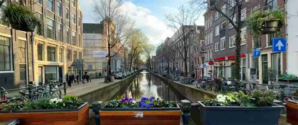
Seventeenth-Century Canal Ring Area of Amsterdam
Amsterdam’s Canal Ring, inscribed in 2010, represents the Netherlands’ most visited UNESCO site and one of the world’s most recognizable urban landscapes. The concentric canal system built during the Dutch Golden Age demonstrates exceptional urban planning achievement that influenced city development across Europe and colonial territories.
The four main canals—Singel, Herengracht, Keizersgracht, and Prinsengracht—form a distinctive horseshoe pattern designed as an integrated expansion plan approved in 1609. The system addressed Amsterdam’s explosive population growth during its peak commercial prosperity, creating approximately 650 hectares of new urban space with coordinated infrastructure, social organization, and aesthetic ambition.
Over 1,500 monumental buildings line the canals, featuring the distinctive tall, narrow facades with decorative gables characteristic of Dutch Golden Age architecture. The buildings reflect the social hierarchy, with the grandest mansions along Herengracht’s “Golden Bend” and more modest housing in side streets and along Prinsengracht. Multiple architectural styles spanning four centuries create visual richness, from Dutch Renaissance to Art Nouveau, demonstrating the Canal Ring’s continuous evolution as a living urban environment.
The area functions as a working neighborhood rather than a museum district, with residential occupation, commercial activities, cultural institutions, and daily urban life maintaining the spaces’ vitality. Numerous museums occupy historic canal houses, including Museum Van Loon and Museum Willet-Holthuysen, displaying period interiors. The Anne Frank House provides essential World War II context. Walking routes, canal cruises, and cycling paths allow varied exploration of this extensive heritage district.
Van Nellefabriek: Industrial Icon
The Van Nelle Factory in Rotterdam, inscribed in 2014, exemplifies modernist industrial architecture’s highest achievement. Built 1925-1931 as a coffee, tea, and tobacco processing facility, the building pioneered revolutionary design approaches that influenced factory architecture globally.
Architects Brinkman and Van der Vlugt created a structure rejecting traditional enclosed factory design in favor of transparency, natural light, and spatial openness. Glass curtain walls stretching across multiple stories allowed unprecedented interior illumination, improving working conditions while demonstrating modern materials’ aesthetic potential. Mushroom columns supporting floor plates eliminated interior walls, creating flexible space for machinery arrangement. Continuous horizontal window bands emphasized the building’s streamlined profile.
The complex includes main production buildings, administrative offices, a distinctive mushroom-shaped tea packing facility, and a conveyor bridge connecting buildings across a canal. The design incorporated employee welfare facilities unusual for the period: cafeterias with canal views, rooftop gardens, and generous common spaces. This progressive approach reflected Dutch social democratic values while demonstrating how modern architecture could improve working conditions.
Industrial operations ceased in the 1990s, but careful conversion transformed the buildings into creative industry offices, event spaces, and a design center while preserving architectural integrity. The main factory building maintains its dramatic interior volumes, glass walls, and structural expression. Tours explain the building’s revolutionary design, its influence on modernist architecture, and the conversion process balancing preservation with contemporary use. The surrounding park and waterfront provide context for understanding the industrial landscape’s original character.
Colonies of Benevolence: Social Experiment
The Colonies of Benevolence, inscribed in 2021, represent an ambitious 19th-century social experiment addressing poverty through agricultural colonies. This transnational site includes locations in the Netherlands (Frederiksoord, Wilhelminaoord, and Veenhuizen in Drenthe) and Belgium (Wortel), demonstrating early social welfare concepts that influenced later reform movements.
The Society of Benevolence, established in 1818, created these colonies to combat urban poverty by relocating poor families to rural agricultural settlements. The society provided housing, land, agricultural training, and elementary education, expecting families to become self-sufficient through farming. The experiment represented Enlightenment ideals applied to social problems, combining paternalistic charity with progressive education concepts.
The colonies’ landscape organization reflected social control through spatial planning. Grid layouts with standardized houses, central squares, and prominent institutions (churches, schools, administrative buildings) created ordered communities contrasting with perceived urban chaos. Agricultural plots, forests, and heathlands provided resources and work opportunities. Later development added facilities for “involuntary” colonists—vagrants, beggars, and orphans sent by authorities rather than volunteering.
The Dutch colonies evolved differently from the Belgian site. Frederiksoord maintained its original character as a “free” colony, while Veenhuizen developed into a massive complex including prisons and mental institutions. Today, the sites feature museums explaining colony history, preserved buildings showing original layouts, and landscape features demonstrating the settlement planning. Walking routes connect various elements across the extensive sites. The transnational designation acknowledges the colonies’ broader influence on European and American social welfare movements.
Lower German Limes: Roman Frontier
The Lower German Limes, inscribed in 2021 as part of the transnational “Frontiers of the Roman Empire” World Heritage property shared with Germany, preserves remains of the Roman Empire’s northwestern boundary. The Dutch section includes archaeological sites along the Old Rhine demonstrating Roman military organization and frontier life from the 1st through 5th centuries.
Roman expansion northward reached natural limits at the Rhine River, where Germanic tribes prevented further conquest. The Romans established a defensive frontier (limes) with military camps, forts, watchtowers, and civilian settlements protecting the empire’s borders. The Lower German Limes extended from the North Sea to the Middle Rhine, controlling trade, monitoring tribal movements, and demonstrating Roman power.
Archaeological sites in the Netherlands include Katwijk (ancient Lugdunum), where a Roman lighthouse foundation remains visible on the beach, and Leiden (Matilo), where excavations revealed fort structures. Near Utrecht, Castellum Hoge Woerd reconstruction demonstrates typical Roman fort architecture using archaeological evidence. The sites preserve foundations, pottery, military equipment, and structural remains documenting four centuries of Roman presence.
The Lower German Limes differs from other Roman frontier sections in lacking continuous wall structures. The Rhine itself provided natural defense, supplemented by forts at strategic locations. This arrangement influenced later Dutch water defense concepts, showing continuity in using waterways for military advantage. Museums in Leiden, Utrecht, and other locations display archaeological finds and explain Roman frontier life. The sites connect to broader European Roman heritage, allowing understanding of how frontier provinces functioned within the empire’s administrative and military systems.
Royal Eise Eisinga Planetarium: Astronomical Achievement
The Royal Eise Eisinga Planetarium in Franeker, inscribed in 2023 as the newest Dutch UNESCO site, preserves the world’s oldest working planetarium. Built 1774-1781 by amateur astronomer Eise Eisinga, the mechanical model demonstrates the solar system’s operation using an extraordinary gear mechanism installed in his living room ceiling.
Eisinga, a wool comber by profession, constructed the planetarium to counter panic caused by a preacher’s false prediction that planetary alignments would cause Earth’s destruction. The device accurately models the six known planets’ orbital periods using over 10,000 handmade nails forming gear teeth. Mercury completes its orbit in 88 days, while Saturn requires 29.5 years, all maintaining proper relative velocities. The mechanism continues functioning today using its original clockwork drive, requiring weekly winding.
The planetarium ceiling presents a cosmic map with moving spheres representing planets painted Delft blue against white plaster. Dials around the room’s perimeter display additional astronomical information including lunar phases, zodiac positions, and calendar dates. The integration of scientific precision with 18th-century domestic space creates extraordinary visual and intellectual impact.
The adjacent museum houses Eisinga’s workshop, astronomical instruments, and exhibits explaining 18th-century astronomy. The preservation maintains authentic period character while explaining the mathematical and mechanical principles underlying the planetarium’s operation. UNESCO recognition acknowledges the achievement’s universal significance in scientific instrument making and public science education. The site demonstrates how Enlightenment values promoting rational understanding reached beyond academic circles into artisan communities.
Wadden Sea: Natural Heritage
The Wadden Sea, inscribed progressively from 2009-2014 as a transnational site shared among the Netherlands, Germany, and Denmark, represents the world’s largest unbroken system of intertidal sand and mud flats. This natural UNESCO site contrasts with the Netherlands’ predominantly cultural heritage, preserving essential coastal ecosystems and migration routes.
The Wadden Sea stretches along 500 kilometers of North Sea coastline, covering over one million hectares. Twice-daily tidal fluctuations expose vast mudflats during low tide and submerge them during high tide, creating dynamic environments supporting extraordinary biodiversity. Over 10,000 plant and animal species inhabit the area, including 10-12 million migratory birds annually using the region as a stopover between breeding grounds and winter habitats.
The Dutch Wadden Sea section includes the Frisian Islands—barrier islands separating the shallow Wadden Sea from the open North Sea. These islands feature unique ecosystems combining beach, dune, and salt marsh habitats. The mainland coast preserves additional salt marshes and tidal channels. The entire system demonstrates natural processes of barrier island formation, sediment transport, and ecosystem adaptation to tidal dynamics.
Visitors experience the Wadden Sea through multiple activities. Wadlopen (mudflat hiking) allows crossing between mainland and islands during low tide under licensed guide supervision. Ferry services connect islands offering beach recreation, nature observation, and traditional fishing village exploration. Bird watching facilities provide access to migration spectacles during spring and autumn passages. Seal colonies inhabiting sandbanks can be observed from boats or designated viewing areas. The experience emphasizes ecosystem fragility, conservation importance, and natural processes functioning beyond human control.
Visiting Strategies and Practical Information
Effective exploration of Netherlands UNESCO sites requires strategic planning accounting for geographic distribution, seasonal considerations, and varying access requirements. The sites’ diversity demands different visiting approaches and time allocations.
Amsterdam-based visitors access multiple sites easily. The Canal Ring provides immediate UNESCO experience through walking tours, canal cruises, and museum visits. Utrecht lies 30 minutes away by train, allowing half-day trips to the Rietveld Schröder House (advance booking required). Rotterdam’s Van Nelle Factory requires similar travel time, though factory visits suit weekdays when creative businesses occupy the spaces. Beemster Polder lies north of Amsterdam, accessible via car rental or organized tours combining polder exploration with Waterland region villages.
Northern sites require dedicated visits or overnight stays. The Wadden Sea region benefits from multi-day exploration, allowing island visits, mudflat walking experiences, and mainland nature reserves. Franeker’s Eise Eisinga Planetarium combines with Frisian towns tour, while the Wouda Steam Pumping Station near Lemmer fits northern itineraries. These sites reward slower exploration emphasizing regional culture beyond specific UNESCO monuments.
Southern and eastern sites scatter more widely. Kinderdijk lies between Rotterdam and Dordrecht, reachable via waterbus services or driving. The Water Defence Lines extend across central Netherlands with fort access varying by location—some function as museums with regular hours, others require appointments or appear only as landscape features. The Colonies of Benevolence in Drenthe suit road trip exploration, combining UNESCO sites with scenic countryside.
Seasonal timing affects experiences significantly. Spring (April-June) brings optimal weather, blooming landscapes, and full site operations. The Kinderdijk mills operate sails regularly, outdoor fortifications become accessible, and Wadden Sea bird migrations peak. Summer extends opening hours and adds special events, though tourist numbers increase. Autumn offers spectacular colors in canal-side trees and polder landscapes, with moderate crowds. Winter limits access to some sites, particularly outdoor fortifications and Wadden Sea activities, though Amsterdam’s Canal Ring maintains year-round accessibility.
Transportation options include comprehensive train networks reaching most sites, bike rental for local exploration (particularly effective in flat polder landscapes), car rental allowing access to dispersed Water Defence Lines forts and Colonies of Benevolence, and specialized tours focusing on specific UNESCO themes. Public transport proves sufficient for major sites, while minor fortifications and remote locations benefit from automotive flexibility.
Thematic Connections and UNESCO Values
Understanding thematic connections between Dutch UNESCO sites reveals how individual locations contribute to broader heritage narratives. The water management theme provides obvious linkage, but deeper analysis shows additional organizational principles reflecting Dutch cultural values and historical development.
Innovation through constraint emerges as a unifying concept. The Dutch confronted geographic limitations—flooding, limited space, soft foundation soils—and developed solutions that became global models. Beemster Polder’s perfect grid influenced later land reclamation worldwide. The Canal Ring’s integrated planning inspired urban development across European colonies. The Van Nelle Factory’s revolutionary transparency transformed industrial architecture. Each innovation responded to specific Dutch conditions while achieving universal applicability.
Social organization visible in spatial planning connects multiple sites. The Canal Ring’s social hierarchy expressed through building scale and location, the Colonies of Benevolence’s ordered agricultural layouts, and the Water Defence Lines’ strategic positioning all demonstrate how physical space reflected and reinforced social structures. This characteristic appears throughout Dutch heritage, from hofjes (charitable courtyard housing) to polder village organization.
Technological progression tracks through water management sites. Schokland shows traditional dike building’s limits, Kinderdijk demonstrates windmill-powered drainage effectiveness, the Wouda Station represents steam power’s application, and modern electric pumps maintain systems today. This evolution didn’t discard earlier technologies—windmills remain operational, the Wouda Station provides emergency backup—creating layered heritage preserving multiple technological eras.
Cultural exchange and adaptation appear in unexpected locations. Willemstad demonstrates Dutch architectural principles transformed by Caribbean context. The Rietveld House applies international De Stijl concepts to domestic Dutch architecture. The Roman Limes shows frontier cultural mixing. These examples reveal Dutch engagement with broader cultural movements while maintaining distinctive national characteristics.
UNESCO recognition values vary by site. Schokland emphasizes human struggle with natural forces. The Canal Ring celebrates urban planning achievement. The Van Nelle Factory demonstrates industrial design advancement. The Wadden Sea preserves natural processes. The Eise Eisinga Planetarium honors scientific instrument making and public education. This diversity reflects UNESCO’s evolving criteria while showcasing Dutch heritage’s multifaceted character.
Conservation Challenges and Management
Managing thirteen diverse UNESCO sites presents distinct conservation challenges requiring specialized approaches for different heritage types. The sites face varying threats from climate change, tourism pressure, urban development, and maintenance requirements.
Water management sites confront changing climate conditions. Rising sea levels and increased precipitation intensity stress systems designed for historical weather patterns. The Wadden Sea ecosystem adapts to changing temperatures affecting species distribution. Kinderdijk’s windmills, though no longer primary drainage tools, require maintenance preserving traditional techniques while incorporating modern materials when necessary. The Wouda Steam Pumping Station balances operational readiness with heritage preservation, occasionally operating for flood protection while maintaining historical machinery.
Urban heritage sites manage tourism impacts while maintaining residential character. Amsterdam’s Canal Ring experiences enormous visitor numbers potentially overwhelming local communities and infrastructure. Management strategies limit canal boat numbers, regulate accommodation conversions preventing neighborhood depopulation, and balance commercial development with residential needs. Building conservation requires strict regulation ensuring facade modifications respect historical character while allowing necessary modern amenities.
Architectural monuments face structural preservation challenges. The Rietveld Schröder House’s innovative construction used materials now requiring specialized conservation. The Van Nelle Factory’s glass curtain walls need ongoing maintenance. Both sites limit visitor numbers protecting fragile interiors while maintaining public access. Modern conservation techniques allow stabilization without compromising historical authenticity.
Archaeological sites like the Lower German Limes balance excavation, preservation, and presentation. Underwater archaeology along the Wadden Sea coast reveals additional Roman remains threatened by erosion. Conservation strategies include protective burial, controlled excavation, and digital documentation creating permanent records of threatened sites.
Climate adaptation emerges as an urgent conservation priority. The Dutch Water Defence Lines, designed for controlled flooding, now face extreme weather events exceeding original design parameters. Adaptation strategies maintain heritage values while acknowledging these systems no longer provide military defense, instead serving ecological and recreational functions. The transformation demonstrates heritage’s living character, continually adapting to contemporary needs.
Frequently Asked Questions
Which Netherlands UNESCO site is most worth visiting?
Amsterdam’s Canal Ring offers the most comprehensive and accessible UNESCO experience, combining world-class museums, architectural variety, walking routes, and integration into a vibrant urban environment. Visitors experience Golden Age heritage while enjoying contemporary Amsterdam’s restaurants, shops, and cultural activities. However, “most worth visiting” depends on individual interests: architecture enthusiasts prioritize the Rietveld Schröder House and Van Nelle Factory, nature lovers favor the Wadden Sea, and those interested in water management find Kinderdijk and the Wouda Pumping Station essential. The sites’ diversity allows matching UNESCO visits to specific interests rather than identifying a single “best” location.
How much does it cost to visit Dutch UNESCO sites?
Costs vary dramatically by site type and visiting approach. Amsterdam’s Canal Ring offers free walking exploration, though museums charge admission (Rijksmuseum €22.50, Van Gogh Museum €20, canal house museums €15-20). Kinderdijk entrance costs €11 including mill interiors and museum access. The Rietveld Schröder House tour costs €22 with mandatory advance booking. Van Nelle Factory tours cost €15. The Wouda Pumping Station charges €10 for guided tours. The Eise Eisinga Planetarium costs €7. Beemster Polder and Schokland remain free for landscape exploration, with optional museum visits around €5-8. Wadden Sea activities range from free beach access to €30-60 for guided mudflat walks. A comprehensive UNESCO site visit spanning one week costs approximately €200-300 per person for admissions, plus transportation, accommodation, and meals.
Can you visit the Water Defence Lines forts?
Many Water Defence Lines forts welcome visitors, though accessibility varies significantly across the 102+ fortifications. Approximately 30 forts function as museums, restaurants, hotels, or cultural centers with regular public access. Fort bij Vechten near Utrecht houses the Dutch Water Museum explaining the entire defense system with excellent exhibits. Fort bij Hoofddorp operates as a museum and event venue. Fort Everdingen offers tours and outdoor activities. Fort bij Spijkerboor functions as a restaurant. Several forts provide overnight accommodation combining heritage experience with lodging. Other forts remain military property, private residences, or ruins visible only from public paths. The Stelling van Amsterdam foundation maintains comprehensive information about fort access, opening hours, and special events. Walking and cycling routes connect accessible forts, allowing multi-fort tours appreciating the defense system’s scale and strategic positioning.
What is the best way to see Beemster Polder?
Cycling provides the optimal Beemster Polder experience, allowing appreciation of the geometric landscape at a pace revealing its Renaissance order while covering sufficient distance to understand the polder’s scale. Multiple cycling routes circuit the polder using dedicated bike paths along canals and minor roads with minimal traffic. The approximately 30-kilometer outer ring route follows the main dike perimeter, while shorter internal routes cross through agricultural areas. Starting from Middenbeemster village provides access to the Museum Betje Wolff explaining polder history and the restored De Nachtegaal windmill. Car touring allows efficient polder overview but misses detailed landscape appreciation. Walking suits limited exploration around specific villages but proves impractical for comprehensive coverage. Organized bike tours from Amsterdam include rental bikes, guide services, and polder cheese tastings at working farms. Spring through autumn offers best cycling conditions, with summer’s warm weather offset by agricultural activity creating photographic opportunities.
Is Curaçao’s Willemstad worth the trip from Europe?
Willemstad justifies Caribbean travel primarily when combined with broader Curaçao vacation plans rather than as a standalone UNESCO site pilgrimage. The historic districts preserve exceptional colonial architecture in a tropical setting, offering unique heritage experiences unavailable in European Netherlands. However, the 9-hour flight and substantial costs make dedicated UNESCO tourism economically questionable. Visitors planning Caribbean holidays should absolutely include Willemstad’s heritage districts, spending 1-2 days exploring Punda, Otrobanda, fort remains, and museums. The combination of UNESCO culture with beach relaxation, diving, and tropical landscapes creates comprehensive vacation experiences. For UNESCO completists seeking all Kingdom sites, the trip becomes necessary, best combined with diving, snorkeling, or Curaçao’s natural attractions. The site’s Caribbean context provides important perspective on Dutch colonial history and architectural adaptation beyond metropolitan patterns.
When is the best time to photograph Kinderdijk windmills?
Late afternoon and sunset during spring or autumn provide optimal Kinderdijk photography conditions, combining favorable light angles with seasonal landscape colors. Spring brings blooming trees and green polders, while autumn adds golden tones to vegetation and creates atmospheric mist during cool mornings. The windmills’ orientation allows western light to illuminate facades during afternoon hours, with sunset creating dramatic silhouettes. Saturday mornings when mills operate their sails (April-October) add motion and authenticity to photographs. Winter’s early sunsets and bare trees create stark minimalist compositions. Summer’s extended daylight allows golden hour photography after 8 PM but brings maximum tourist numbers. The walking paths circling the mill network provide varied perspectives, with the path along the Lek River offering classic compositions including multiple mills, water reflections, and canal elements. Sunrise photography captures the eastern mills in warm light with reflective conditions before visitor arrival.
How difficult is Wadden Sea mudflat walking?
Wadden Sea mudflat walking (wadlopen) requires moderate fitness levels but presents more mental than physical challenge for most participants. The activity involves walking 5-15 kilometers across exposed seabed during low tide, typically requiring 2-5 hours depending on route. The soft mud creates resistance requiring more effort than normal walking, while uneven surfaces and occasional deeper spots demand attention. Licensed guides lead all walks, selecting routes based on group abilities and ensuring safe timing between tides. The experience suits families with children over 12, though shorter routes accommodate younger participants. Physical challenges include sustained walking in mud resistance, possible waist-deep water crossings at channels, and exposure to sun, wind, and temperature variations. Mental aspects involve accepting temporary inability to retreat mid-route (tides prevent turning back) and maintaining group pace. Proper preparation includes fitness assessment, appropriate clothing, and understanding weather conditions affect difficulty significantly. Most participants complete walks successfully, finding the unique environment and achievement rewarding despite physical demands.
Can you tour the Van Nelle Factory interior?
Van Nelle Factory tours access the main production building’s dramatic interior spaces, including the multi-story factory hall with its distinctive glass curtain walls, mushroom columns, and original spatial organization. The facility now houses creative businesses, event spaces, and a design center, limiting tour access to public areas and selected office spaces when businesses permit. Guided tours operate weekends, explaining the building’s revolutionary design, construction techniques, industrial heritage, and contemporary adaptive reuse. The tour includes the iconic conveyor bridge, administrative sections, and, when available, specialized areas like the former tea packing facility. Photography is permitted in public spaces. Tour booking is recommended during summer months and around special events. Weekday visits allow observing the building’s working atmosphere as creative professionals occupy the spaces, though this limits access compared to weekend tours. The surrounding park and exterior viewing provide excellent architectural appreciation even without interior access.
Which UNESCO site best represents Dutch innovation?
The Van Nelle Factory most powerfully demonstrates Dutch innovation’s characteristics: practical problem-solving through revolutionary design, social progressive values integrated with commercial success, and influence extending far beyond the Netherlands. The building solved industrial production challenges while pioneering architectural approaches that transformed global factory design. The innovation wasn’t purely aesthetic—improved worker conditions, natural lighting, and flexible space demonstrated how modern design could enhance both efficiency and human welfare. This combination of pragmatic function and idealistic vision epitomizes Dutch innovation across multiple fields. However, other sites represent innovation differently: Beemster Polder shows precision engineering and land creation, the Eise Eisinga Planetarium demonstrates amateur scientific achievement, and the Water Defence Lines reveal strategic military thinking. Dutch innovation’s diversity means various sites best represent specific innovation types—technical, social, artistic, or strategic.
Are there combination tickets for multiple UNESCO sites?
No comprehensive combination ticket covers multiple Dutch UNESCO sites, as the sites operate independently under different management organizations. However, several partial combination options exist. The Museumkaart (Museum Card) costs €65 annually and provides free entry to approximately 400 museums including several UNESCO-related institutions: the Amsterdam Museum, various Water Defence Lines fort museums, Museum Schokland, and numerous canal house museums in Amsterdam. The I Amsterdam City Card includes 24/48/72-hour options (€60-95) covering Amsterdam’s Canal Ring museums, public transportation, and canal cruises. Some regional tourist cards include specific sites: the Holland Pass covers major Amsterdam museums. The lack of comprehensive UNESCO ticketing reflects the sites’ diversity—natural areas like the Wadden Sea, public spaces like the Canal Ring walking routes, and specialized sites like the Rietveld House each operate under different access models making unified ticketing impractical.