
L’Anse aux Meadows UNESCO World Heritage Guide: Viking Settlement & Archaeological Significance
At the northernmost tip of Newfoundland’s Great Northern Peninsula, the archaeological remains of an 11th-century Norse settlement provide irrefutable evidence of the first European presence in North America, predating Christopher Columbus by nearly five centuries. This UNESCO World Heritage Site preserves the only verified Viking settlement on the continent outside Greenland, offering profound insights into Norse exploration, medieval transatlantic contact, and the brief but remarkable intersection of European and Indigenous North American worlds during the Viking Age.
Key Takeaways
- First European Settlement in the Americas: L’Anse aux Meadows contains the remains of a Norse encampment established around the year 1000, making it the earliest confirmed European settlement in the New World and predating Columbus’s 1492 voyage by approximately 492 years.
- UNESCO Recognition and Archaeological Significance: Designated as one of the first twelve UNESCO World Heritage Sites in 1978 under Criterion (vi), the site represents a unique milestone in human migration and discovery, providing tangible evidence of Viking transatlantic exploration described in medieval Icelandic sagas.
- Eight Norse Structures Documented: Archaeological excavations revealed eight distinct buildings including three large timber-and-sod longhouses, four smaller workshops, and an iron-smelting furnace, demonstrating a complete Norse settlement pattern with living quarters, production facilities, and storage areas.
- Brief Occupation Period: Evidence indicates the settlement was occupied for only three years, serving as a base camp for exploration and resource extraction rather than a permanent colony, with activities focused on boat repair, iron production, and preparation for further voyages southward.
- Connection to Vinland Sagas: The site’s location, layout, and archaeological findings correspond closely to Straumfjord described in Erik the Red’s Saga, identifying L’Anse aux Meadows as the likely base camp from which Norse explorers ventured to warmer southern regions they called Vinland.
- Meeting of Two Migration Streams: The site marks a profound historical moment where descendants of humans who migrated eastward through Europe and westward through Asia encountered each other again after diverging from common African origins tens of thousands of years earlier, making it a powerful symbol of human interconnection.
People Also Ask About L’Anse aux Meadows
Why is L’Anse aux Meadows historically significant?
L’Anse aux Meadows stands as the only archaeologically verified Norse settlement in North America outside Greenland, providing conclusive physical evidence that Vikings reached the New World approximately 500 years before Christopher Columbus. The site transforms Viking saga narratives from literary tradition into verified historical fact, confirming Norse capabilities for transatlantic navigation and settlement establishment during the medieval period. Its significance extends beyond European exploration history to represent a pivotal moment in human migration patterns, as it marks the location where two branches of humanity that had diverged after leaving Africa tens of thousands of years earlier finally reconnected. The settlement’s discovery in 1960 fundamentally revised North American colonization chronology and demonstrated the feasibility of pre-Columbian contact between Europe and the Americas. UNESCO’s recognition in 1978 under Criterion (vi) acknowledges the site’s universal value as a milestone in human discovery, making L’Anse aux Meadows one of the most important archaeological sites for understanding medieval exploration and transcontinental human movement.
What did archaeologists discover at L’Anse aux Meadows?
Excavations at L’Anse aux Meadows uncovered the remains of eight distinct Norse structures arranged in three complexes along a coastal terrace overlooking a shallow bay. The largest complex contained three buildings including a great hall measuring approximately 20 by 16 meters, constructed with vertical wooden posts supporting walls of layered peat turf in architectural styles identical to those found in Norse Greenland and Iceland. Archaeologists recovered hundreds of artifacts including iron boat rivets, a bronze cloak pin, a bone needle, whetstones for sharpening tools, and evidence of iron smelting from local bog ore. The discovery of jasper fire-strikers from Iceland and butternuts from regions far south of Newfoundland confirmed the site’s Norse origin and proved the inhabitants traveled extensively beyond this base camp. Building foundations revealed sophisticated construction techniques including interior hearths, ember pits, and post-and-beam frameworks that would have supported turf roofs. The iron-smelting furnace represents the first documented ironworking in North America, a technology unknown to Indigenous populations at that time. Radiocarbon dating of artifacts and charcoal consistently placed occupation around the year 1000, aligning perfectly with saga descriptions of Leif Erikson’s voyages. The artifact assemblage, architectural details, and construction methods leave no doubt about the settlement’s Norse origin and provide unprecedented insights into Viking daily life, technological capabilities, and exploration strategies in the New World.
How long did Vikings live at L’Anse aux Meadows?
Archaeological evidence indicates Norse occupation at L’Anse aux Meadows lasted approximately three years, representing a temporary base camp rather than a permanent colonial settlement. The limited accumulation of artifacts, minimal wear on building floors, and absence of graves or burials all point to brief habitation. Researchers calculate that constructing the settlement’s eight buildings would have required between 60 to 90 laborers working for one to two months, representing a substantial investment from Greenland’s small population of approximately 400 people at that time. The short occupation period aligns with saga accounts describing exploratory voyages and resource-gathering expeditions rather than sustained colonization efforts. Several factors likely contributed to abandonment after only three years, including conflicts with Indigenous populations documented in saga narratives, the settlement’s unsuitability for large-scale Norse farming practices, and the logistical challenges of maintaining a distant outpost from Greenland with limited population resources. The settlement pattern suggests L’Anse aux Meadows functioned as a staging area for boat repairs, iron production, and preparation for voyages to warmer southern regions where grapes and superior timber resources could be obtained. Following abandonment around 1003, Norse contacts with North America continued sporadically until at least the 14th century for Labrador timber harvesting, but L’Anse aux Meadows itself was never reoccupied, preserving the archaeological remains remarkably intact for discovery 957 years later.
What is the connection between L’Anse aux Meadows and Vinland?
L’Anse aux Meadows is identified by most scholars as Straumfjord, the base camp described in Erik the Red’s Saga, from which Norse explorers journeyed to a warmer southern region they named Vinland. The saga describes Straumfjord as a location with strong currents, a sheltered bay, and access to both forest resources and the open sea, characteristics matching L’Anse aux Meadows precisely. Archaeological evidence supports this identification: butternuts recovered at the site grow only in regions 700 kilometers south of Newfoundland, proving occupants traveled extensively beyond their base camp to areas with climates suitable for grape cultivation mentioned in saga accounts. The settlement’s layout and brief occupation align with saga descriptions of a temporary staging area rather than the final destination. Vinland itself likely refers to regions in New Brunswick or potentially as far south as the Gulf of St. Lawrence, where Norse explorers encountered wild grapes, superior timber, and Indigenous populations. L’Anse aux Meadows served as the northern gateway to these resource-rich southern areas, providing boat repair facilities, iron production capabilities, and protected anchorage for vessels exploring the coastline. The saga’s description of Straumfjord as a place where ships could be beached and repaired matches the shallow, protected bay at L’Anse aux Meadows perfectly. While Vinland denotes the broader exploration territory encompassing multiple locations, L’Anse aux Meadows represents the only physical evidence of Norse infrastructure supporting these voyages, serving as the critical link between saga narratives and archaeological reality.
Extended multi-day tours – 5+ days
Featured Newfoundland And Labrador Multi-Day Tour Packages
3 days
Newfoundland And Labrador 3-Day Discovery Tour
- ✓ Comprehensive Newfoundland And Labrador experience
- ✓ Expert local guides included
- ✓ All accommodation included
- ✓ Transportation provided
5 days
Newfoundland And Labrador 5-Day Highlights Experience
- ✓ Comprehensive Newfoundland And Labrador experience
- ✓ Expert local guides included
- ✓ All accommodation included
- ✓ Transportation provided
7 days
Newfoundland And Labrador 7-Day Cultural Journey
- ✓ Comprehensive Newfoundland And Labrador experience
- ✓ Expert local guides included
- ✓ All accommodation included
- ✓ Transportation provided
10 days
Newfoundland And Labrador 10-Day Complete Adventure
- ✓ Comprehensive Newfoundland And Labrador experience
- ✓ Expert local guides included
- ✓ All accommodation included
- ✓ Transportation provided
Multi-day tour packages powered by TourRadar. Prices and availability subject to change.
Introduction
The discovery of L’Anse aux Meadows in 1960 resolved one of history’s most enduring questions: did Vikings truly reach North America centuries before Columbus, or were the medieval Icelandic sagas merely imaginative fiction? Norwegian explorer Helge Ingstad and his wife, archaeologist Anne Stine Ingstad, followed saga clues and local Newfoundland folklore to identify grass-covered mounds at the northern tip of the Great Northern Peninsula. Seven years of meticulous excavation revealed unmistakable Norse architecture, artifacts, and construction techniques identical to settlements in Greenland and Iceland, transforming saga narratives from disputed legend into verified historical fact.
The site occupies a windswept coastal terrace overlooking a shallow bay where Norse ships could be beached for repairs and provisioning. Eight timber-and-peat-turf buildings arranged in three distinct complexes once housed approximately 70 to 90 Norse men and women who traveled from Greenland around the year 1000 to establish the first European foothold in the Americas. For three brief years, this remote outpost served as a gateway to exploration, resource extraction, and encounters with Indigenous peoples that would be recorded in saga form and remembered in oral traditions for generations.
Today, L’Anse aux Meadows stands as both an archaeological treasure and a UNESCO World Heritage Site of global significance. Parks Canada manages the site with exceptional care, preserving the original building foundations through controlled reburial while maintaining reconstructed Norse structures that allow visitors to experience Viking Age architecture and daily life. The Visitor Centre houses artifacts recovered during excavations, interpretive exhibits explaining Norse exploration, and audiovisual presentations connecting the site to broader Viking Age history. Costumed interpreters demonstrate period crafts and technologies, bringing the settlement’s brief but remarkable history to life against the dramatic backdrop of Newfoundland’s northern coastline.
The site’s significance extends far beyond documenting Viking presence in North America. L’Anse aux Meadows represents a profound moment in human history when two branches of humanity, separated after migrating from common African origins tens of thousands of years earlier, reconnected on North American shores. European descendants who had moved westward through Asia, across Bering land bridges, and eventually southward through the Americas encountered European descendants who had moved eastward through Europe, mastered North Atlantic seafaring, and island-hopped westward through Iceland and Greenland. This reconnection of human migration streams makes L’Anse aux Meadows a powerful symbol of human interconnection and our species’ remarkable capacity for exploration and adaptation across diverse environments.
Discovery and Excavation History
The modern rediscovery of L’Anse aux Meadows began with Norwegian explorer Helge Ingstad’s determination to locate physical evidence of Norse settlements described in Icelandic sagas. For years, scholars debated whether saga accounts of Vinland represented actual voyages or imaginative literature, with no archaeological proof to support transatlantic Norse contact. Ingstad approached the problem methodically, analyzing saga geography, studying North Atlantic navigation patterns, and investigating potential landing sites along the Canadian coast from Rhode Island to Labrador.
In 1960, following leads from local fishermen and investigating grass-covered mounds near the village of L’Anse aux Meadows, Ingstad recognized features consistent with Norse construction. The site’s location matched saga descriptions remarkably well: a protected bay suitable for beaching ships, nearby forests for timber and boat repairs, access to salmon-rich streams, and visibility of distant headlands for navigation. Ingstad’s wife, Anne Stine Ingstad, a trained archaeologist, organized the first systematic excavation in 1961 under challenging conditions in one of North America’s most remote and windswept locations.
Between 1961 and 1968, Anne Stine Ingstad led excavations that progressively revealed eight distinct Norse structures. The first building uncovered proved beyond doubt that Vikings had built at this location: vertical wooden posts set in trenches supported walls of layered peat turf, a construction technique unknown to Indigenous North American cultures but standard in Norse Greenland and Iceland. Subsequent seasons uncovered additional longhouses, workshops, and a remarkably preserved iron-smelting furnace built into a stream bank. Hundreds of artifacts including iron boat rivets, a bronze cloak pin characteristic of Norse women’s dress, a soapstone spindle whorl for spinning wool, whetstones, and bog iron slag confirmed Norse occupation.
The discovery electrified the archaeological community and captured global attention. Radiocarbon dating of charcoal from building hearths consistently indicated occupation around the year 1000, precisely when saga accounts placed Leif Erikson’s voyages. The Ingstads’ meticulous documentation, published in detailed excavation reports, eliminated any lingering doubts about Norse presence in North America. Their work earned international recognition and led directly to the site’s designation as a Canadian National Historic Site in 1968 and UNESCO World Heritage Site in 1978.
Following the Ingstads’ pioneering work, Parks Canada assumed management responsibility and conducted additional excavations in the 1970s under archaeologists Bengt Schönbäck and Birgitta Wallace. These investigations refined understanding of site chronology, building functions, and relationship to Indigenous occupations that preceded and followed Norse use. Wallace’s analysis of artifacts and architectural details conclusively linked L’Anse aux Meadows to Erik the Red’s Saga description of Straumfjord, identifying the site as the base camp from which Norse explorers ventured to warmer Vinland regions farther south. Her research on butternuts recovered at the site proved Norse travel to areas 700 kilometers south where these nuts grow, confirming saga accounts of resource-gathering expeditions.
Modern archaeological investigations continue using non-invasive techniques including ground-penetrating radar, magnetic surveys, and systematic landscape analysis to search for additional Norse structures or artifacts without disturbing preserved remains. These ongoing studies investigate questions about Indigenous-Norse interactions, settlement duration, and the site’s role in broader Norse Atlantic exploration networks. The original building foundations remain carefully reburied and protected, preserving irreplaceable archaeological evidence for future research as technologies advance.
The Norse Settlement: Architecture and Layout
The Norse settlement at L’Anse aux Meadows comprises three distinct building complexes arranged along a coastal terrace approximately 100 meters from a shallow bay. The northernmost complex contains three buildings dominated by a great hall measuring approximately 20 by 16 meters, making it the largest structure at the site and comparable to chieftain halls in Norse Greenland. This building featured a central hearth for cooking and warmth, a stone ember pit for maintaining overnight fires, and separate rooms likely used for sleeping quarters and storage. The hall’s size and prominent position indicate it served as the settlement’s social and administrative center where leaders coordinated activities, hosted gatherings, and made decisions about exploration and resource allocation.
Adjacent to the great hall, a smaller dwelling measuring approximately 14 by 9 meters provided additional living space, possibly housing workers or crew members of lower status. A third structure in this complex appears to have functioned as a storage building based on its layout and lack of hearth features. The middle building complex, located 30 meters south, contained two structures including another substantial dwelling with a central hearth and a smaller workshop or storage facility. The southernmost complex housed a building combining residential and workshop functions, evidenced by the presence of both domestic artifacts and tool-making debris.
The most remarkable structure occupies a special location along Black Duck Brook: an iron-smelting furnace built directly into the stream bank. This ingenious placement utilized flowing water for cooling purposes and provided convenient access to the bog iron ore deposits that Norse smiths extracted from nearby wetlands. The furnace represents the first documented ironworking in North America, a sophisticated technology completely foreign to Indigenous populations and demonstrating Norse self-sufficiency in tool repair and production essential for survival far from Greenland supply sources.
Norse construction techniques at L’Anse aux Meadows mirror those found throughout the Norse Atlantic world from Norway to Greenland. Builders first excavated shallow foundation trenches, then set vertical wooden posts at regular intervals to create structural frameworks. Horizontal wooden beams connected these posts at ground level and presumably at roof height, though no upper beams survived. Workers then filled the wall spaces between posts with layers of peat turf cut from surrounding meadows, creating thick insulating walls that protected inhabitants from harsh North Atlantic weather. Interior floors consisted of trampled earth, occasionally covered with sand or gravel in high-traffic areas.
Roofs utilized similar turf construction, with wooden beams supporting layers of peat that provided excellent insulation and waterproofing. The considerable weight of turf roofs required substantial post-and-beam frameworks, explaining why Norse builders selected large timbers from nearby forests. Interior spaces featured central hearths built from flat stones arranged to contain fires and distribute heat. Ember pits dug beside hearths allowed fires to be banked overnight, maintaining warmth and providing coals for quickly rekindling morning fires without the labor of starting new fires from scratch.
The settlement layout reveals careful planning for functionality and efficiency. Buildings face inland away from prevailing ocean winds, with entrances positioned to minimize exposure to weather. The proximity to Black Duck Brook provided fresh water for domestic use and iron smelting, while the nearby forest supplied construction timber and firewood. The shallow bay offered protected anchorage where Norse ships could be beached at high tide for repairs, caulking, and maintenance. The elevated terrace location provided commanding views of approaching vessels and passing icebergs while keeping buildings above seasonal flooding.
Archaeological evidence indicates approximately 70 to 90 people occupied the settlement simultaneously based on building capacities and artifact distribution. This substantial workforce came from Greenland’s total population of only 400 people, representing a massive commitment of human resources for a distant exploratory enterprise. The presence of items associated with women, including the bronze cloak pin and spindle whorl, confirms that Norse expeditions to L’Anse aux Meadows included both genders, suggesting intentions for more than brief exploration voyages.
Archaeological Significance and Findings
The artifact assemblage recovered from L’Anse aux Meadows provides unprecedented insights into Norse material culture, technological capabilities, and daily life during North American exploration. Despite brief occupation and minimal accumulation of debris, archaeologists recovered hundreds of objects that definitively prove Norse presence and reveal settlement functions. The most diagnostic artifacts include 99 iron boat rivets of characteristic Norse manufacture, essential for clinker-built ship construction where overlapping wooden planks are fastened with iron rivets rather than wooden pegs or lashing used by Indigenous boat builders.
A bronze ringed pin recovered from one building represents one of the most significant finds. This distinctive Norse cloak fastener features a ring that slides along a pin to secure woolen cloaks, a dress accessory characteristic of Viking Age women throughout Scandinavia and Norse Atlantic settlements. The pin’s presence confirms women accompanied expeditions to L’Anse aux Meadows, fundamentally revising earlier assumptions that all Norse North American voyages involved only male crews. The artifact’s excellent preservation in Newfoundland’s acidic peat soil allowed detailed typological analysis linking it to 10th-11th century Scandinavian examples.
Stone artifacts include whetstones for sharpening iron tools and weapons, essential equipment for maintaining axes, knives, and other implements far from Greenland sources. Several whetstones show characteristic wear patterns from repeated tool sharpening, demonstrating regular use during occupation. A soapstone spindle whorl provides additional evidence of Norse textile production, as spinning wool into thread represented essential work for creating and repairing clothing in cold climates. The whorl’s presence indicates occupants engaged in routine domestic activities beyond basic survival needs.
Iron slag and furnace remains document local smelting operations that produced iron from bog ore deposits. Norse smiths extracted iron-rich nodules from surrounding wetlands, roasted them to remove impurities, then smelted the processed ore in the stream-bank furnace to produce workable iron. This technological capability allowed tool repair, nail production, and replacement of iron equipment damaged during voyages or daily use. The ability to smelt iron represented a critical advantage for Norse expeditions, eliminating dependence on imported iron supplies from Greenland and enabling extended operations in North America.
Jasper fire-strikers, used with steel to create sparks for starting fires, came from sources in Iceland, proving direct connections between L’Anse aux Meadows and Iceland despite the settlement’s nominal administration from Greenland. These fire-starting tools demonstrate the Norse practice of carrying familiar equipment from homeland sources even when establishing distant outposts. The jasper’s Icelandic origin provides material evidence for the complex network of North Atlantic Norse settlements spanning Norway, Iceland, Greenland, and ultimately North America.
Perhaps the most revealing discovery consists of butternut shells and butternuts recovered during excavations. Butternut trees grow only in temperate zones beginning approximately 700 kilometers south of L’Anse aux Meadows, in regions of New Brunswick and the St. Lawrence Valley. The nuts’ presence proves Norse occupants traveled extensively beyond their Newfoundland base camp to warmer southern areas, almost certainly the grape-growing regions described in saga accounts of Vinland. This botanical evidence provides the strongest archaeological support for identifying L’Anse aux Meadows as Straumfjord, the base camp from which Norse explorers ventured to Vinland proper rather than Vinland itself.
Radiocarbon dating of charcoal samples from building hearths consistently places occupation around the year 1000, with most dates falling between 990 and 1030. This chronology aligns perfectly with saga accounts describing Leif Erikson’s exploration around the year 1000 and subsequent voyages by family members and colonists in following years. The dating evidence eliminates any possibility that L’Anse aux Meadows represents later Norse contact with North America, firmly linking the settlement to the Viking Age exploration period described in medieval literature.
The absence of certain artifact types proves equally significant for understanding settlement function. No graves, burials, or cemeteries exist at L’Anse aux Meadows, indicating occupants departed alive and never established a permanent community where people lived out their lives. The limited quantity of broken pottery, discarded tools, and accumulated debris suggests brief habitation rather than years of continuous occupation. No agricultural implements or evidence of farming appear in the archaeological record, confirming the settlement served as a base camp for resource extraction rather than an agricultural colony.
Faunal analysis of animal bones reveals Norse diet consisted primarily of salmon from nearby streams, supplemented by caribou hunted in surrounding forests and occasional seals from coastal waters. The bone assemblage closely resembles dietary patterns from Norse Greenland sites, showing occupants maintained traditional food preferences while adapting to North American resources. The absence of domesticated cattle, sheep, or goat bones distinguishes L’Anse aux Meadows from permanent Norse settlements where livestock farming formed the economic foundation.
UNESCO World Heritage Designation
L’Anse aux Meadows achieved UNESCO World Heritage status in 1978 as one of the first twelve sites inscribed on the newly created World Heritage List, sharing this inaugural honor with landmarks including the Galápagos Islands, Yellowstone National Park, and Aachen Cathedral. The site’s selection for immediate inclusion in this prestigious designation demonstrates global recognition of its exceptional historical significance and universal value for understanding human exploration and migration patterns. UNESCO designated L’Anse aux Meadows under Criterion (vi), which recognizes properties “directly or tangibly associated with events or living traditions, with ideas, or with beliefs, with artistic and literary works of outstanding universal significance.”
The World Heritage Committee’s statement of Outstanding Universal Value declares: “L’Anse aux Meadows is the first and only known site established by Vikings in North America and the earliest evidence of European settlement in the New World. As such, it is a unique milestone in the history of human migration and discovery.” This recognition emphasizes the site’s role in documenting transatlantic contact five centuries before Columbus and confirming Norse seafaring capabilities that enabled exploration across the most challenging ocean routes known to medieval civilizations.
The site’s integrity receives strong protection through Canadian federal legislation designating it as a National Historic Site managed by Parks Canada. The protected area encompasses 7,991 hectares, extending far beyond the immediate archaeological remains to include surrounding landscapes, viewsheds, and buffer zones that preserve the site’s remote, windswept character essential for understanding Norse settlement choices. This extensive protection ensures the property remains intact and maintains the visual and environmental context critical for appreciating Norse explorers’ experiences at this northern extremity of North America.
Parks Canada employs sophisticated conservation strategies to protect fragile archaeological remains from deterioration. Following complete excavation and documentation, original building foundations were carefully reburied using techniques that prevent oxygen exposure and biological degradation while maintaining structural integrity. This controlled reburial preserves irreplaceable archaeological evidence for future research using technologies not yet developed, while protecting remains from weathering, erosion, and human interference. Regular monitoring ensures reburial effectiveness and identifies any conservation concerns requiring intervention.
Reconstructed Norse buildings occupy separate locations away from original foundations, preventing physical impact on archaeological resources while providing visitors with authentic architectural experiences. These faithful reproductions follow construction techniques documented through excavation, utilizing similar materials, dimensions, and structural methods to recreate Norse living and working environments. Costumed interpreters demonstrate period activities within reconstructed spaces, bringing history to life without compromising protected archaeological deposits.
The Visitor Centre, constructed in the 1980s on a hillside overlooking the settlement area, provides comprehensive interpretation without intruding on the historic landscape. Exhibits display original artifacts recovered during excavations, detailed models showing building reconstruction, audiovisual presentations explaining Norse exploration, and educational materials connecting L’Anse aux Meadows to broader Viking Age history. The centre’s hilltop position offers spectacular views across the site, bay, and surrounding coastal landscapes, allowing visitors to appreciate the environmental setting Norse explorers encountered.
UNESCO monitoring ensures continued protection and management according to World Heritage standards. Parks Canada submits regular conservation reports documenting site conditions, visitor management strategies, research activities, and any threats requiring attention. The World Heritage Committee reviews these reports and provides recommendations for maintaining Outstanding Universal Value. This international oversight adds an additional layer of protection beyond national legislation, ensuring L’Anse aux Meadows receives the highest standard of care appropriate for its global significance.
In 2017, minor boundary modifications reduced the World Heritage property by removing the Beak Point area, which archaeological research determined was mistakenly included in the original designation as it contains no Norse remains. This refinement demonstrates responsible management practices that ensure World Heritage status applies only to areas genuinely associated with Outstanding Universal Value, maintaining the integrity and credibility of the World Heritage system.
Connection to Viking Sagas and Vinland
The archaeological evidence at L’Anse aux Meadows provides remarkable correlation with locations and events described in medieval Icelandic sagas, particularly the Saga of Erik the Red and the Saga of the Greenlanders. These narratives, written down in the 13th century but preserving oral traditions from 200 years earlier, describe Norse voyages to lands west of Greenland around the year 1000. For centuries, scholars debated whether these accounts represented historical events or literary fiction embellished through generations of retelling. The discovery of L’Anse aux Meadows transformed this debate by providing physical evidence that validates core saga elements while revealing limitations in using literature as historical documentation.
The Saga of Erik the Red describes a place called Straumfjord, meaning “Current Fjord,” where Norse explorers established a base camp characterized by strong tidal currents, a sheltered bay suitable for ship maintenance, nearby forests for timber, and access to both coastal and inland resources. The saga portrays Straumfjord as a staging area rather than a final destination, from which explorers ventured south to warmer regions rich in grapes and superior timber. L’Anse aux Meadows matches these descriptions with striking precision: the site overlooks a shallow bay with strong tidal flows, provides protected anchorage for beaching vessels, offers nearby forest resources, and occupies a location from which voyages to southern temperate zones would have been logical.
Most significantly, the butternut evidence from L’Anse aux Meadows provides botanical proof that occupants traveled to regions 700 kilometers south where these nuts grow. This archaeological finding validates saga accounts of expeditions to grape-growing areas, demonstrating that Norse explorers did indeed venture to warmer southern locations from their northern base camp. The sagas describe a place called Hóp, a landlocked bay or estuary with extensive beaches where grapes grew abundantly and timber resources exceeded anything available in Greenland or Iceland. While Hóp’s exact location remains unconfirmed, likely candidates include areas in New Brunswick, the St. Lawrence Valley, or potentially as far south as the Gulf of St. Lawrence, all within feasible sailing range from L’Anse aux Meadows.
The saga accounts of Vinland present interpretive challenges because medieval scribes likely conflated multiple voyages, combined distinct locations into composite descriptions, and embellished narratives with dramatic elements serving literary purposes rather than historical accuracy. The name “Vinland” itself raises questions, as scholars debate whether it refers to “wine land” from grapes, “meadow land” from an alternative Old Norse interpretation, or possibly a descriptor for the abundance of resources rather than a specific geographic designation. Archaeological evidence suggests “Vinland” functioned as a general term encompassing multiple locations along the North American coast where Norse explorers found valuable resources, with L’Anse aux Meadows serving as the gateway to this broader exploration territory.
The saga of the Greenlanders attributes the initial discovery of North American lands to Bjarni Herjólfsson, a merchant blown off course around 985 while sailing from Iceland to Greenland. Bjarni’s accounts of forested lands to the west supposedly inspired Leif Erikson, son of Greenland’s founder Erik the Red, to purchase Bjarni’s ship around the year 1000 and sail west to investigate. The saga describes Leif’s voyage discovering progressively more hospitable lands moving southward: first Helluland (“Flat Stone Land,” likely Baffin Island), then Markland (“Forest Land,” likely Labrador), and finally Vinland where he established a winter camp. This geographic progression matches the actual coastline Norse sailors would have encountered sailing south from Greenland, lending credibility to the narrative structure even if specific details may be embellished.
Subsequent saga accounts describe a larger colonization attempt led by Thorfinn Karlsefni around 1010, involving approximately 160 colonists including women and livestock. This expedition supposedly used Leif’s base camp, spent three years attempting to establish a permanent settlement, and ultimately withdrew due to conflicts with Indigenous peoples the Norse called Skrælings. The archaeological evidence of only three years’ occupation at L’Anse aux Meadows aligns remarkably well with this saga chronology, suggesting the site may indeed represent the base camp used by both Leif’s initial exploration and Karlsefni’s subsequent colonization attempt.
The sagas vividly describe encounters between Norse explorers and Indigenous North Americans, portraying initial peaceful trading that deteriorated into violent conflicts resulting in casualties on both sides. These accounts, while potentially exaggerated for dramatic effect, likely reflect genuine cultural contact events. Indigenous populations certainly inhabited regions adjacent to L’Anse aux Meadows, and Norse expeditions venturing southward would inevitably have encountered more densely populated coastal areas. The saga emphasis on conflicts as a primary reason for Norse withdrawal from North America may accurately reflect the challenges of maintaining distant outposts against hostile Indigenous populations far outnumbering the few hundred Norse colonists available in Greenland.
Modern scholarship recognizes the sagas as valuable historical sources requiring critical analysis rather than literal interpretation. The discovery of L’Anse aux Meadows validated the sagas’ core premise that Norse explorers reached North America and established infrastructure supporting resource extraction. However, the archaeological record also reveals saga limitations: embellished heroic episodes, compressed chronologies combining multiple voyages, and literary conventions that prioritized entertaining narratives over documentary accuracy. The relationship between sagas and archaeology demonstrates how material evidence and textual sources complement each other, with physical remains confirming broad historical patterns while revealing the complexity literature simplifies.
The Norse in North America: Historical Context
Norse presence at L’Anse aux Meadows represents the culmination of a remarkable westward expansion across the North Atlantic that began in the late 8th century and continued for more than 400 years. This migration originated in Scandinavia, where population pressure, limited agricultural land, political consolidation, and a culture celebrating seafaring exploration drove Norse communities to seek new territories. The westward movement proceeded in stages, with each successful colonization establishing a foundation for further exploration to the next distant landmass.
Norwegian Vikings first settled Iceland beginning around 870, transforming an uninhabited volcanic island into a thriving agricultural society that became a cultural center preserving Norse traditions, literature, and historical memory. From Iceland, Norse navigators explored westward, discovering the east coast of Greenland around 982 under Erik the Red’s leadership after his exile from Iceland for killings. Erik established two main settlements on Greenland’s southwestern coast where sheltered fjords and limited coastal meadows supported livestock farming similar to Iceland’s economy. By the year 1000, Greenland’s Norse population numbered approximately 400 people concentrated in these precarious agricultural communities at the extreme western edge of European settlement.
Greenland’s Norse colonists faced severe environmental limitations that made further westward exploration economically attractive. The island offered minimal forest resources, forcing expensive timber imports from Norway or Labrador for essential construction needs. Iron sources consisted only of limited bog deposits inferior to European ores. Agriculture struggled against short growing seasons and marginal soils, requiring supplementation through hunting and fishing. The Greenland population remained small because limited productive land could support only restricted numbers. These resource constraints created powerful incentives for exploring lands farther west that navigators inevitably sighted when sailing between Iceland and Greenland.
The discovery of forested coasts to the west, easily accessible from Greenland’s settlements by experienced North Atlantic sailors, offered solutions to critical resource shortages. Labrador’s vast forests provided unlimited timber for ship repairs, building construction, and fuel. North American waters teemed with salmon, cod, and marine mammals surpassing Greenland’s depleted fishing grounds. The iron-rich bog deposits at L’Anse aux Meadows enabled local smelting, eliminating dependence on expensive Norwegian imports. Regions farther south offered even greater abundance including superior hardwood timber, warmer climates extending growing seasons, and wild grapes suggesting viticulture potential.
Norse exploration of North America followed established patterns of resource extraction rather than large-scale colonization. Similar to their exploitation of Labrador forests for timber and Baffin Island for walrus ivory, Norse expeditions to L’Anse aux Meadows and points south sought specific valuable resources to support Greenland’s economy. The settlement’s brief three-year occupation, modest size, and absence of agricultural infrastructure indicate Norse leaders viewed North America as a resource frontier rather than a colonization target. This pragmatic approach made economic sense given Greenland’s small population, which could not spare large numbers of colonists for distant settlements while maintaining viability in the homeland.
The ultimate Norse withdrawal from L’Anse aux Meadows and apparent cessation of sustained North American contact resulted from multiple factors. Conflicts with Indigenous populations, recorded in both saga accounts and potentially evidenced by defensive site layouts, posed serious security threats to small Norse groups venturing far from their base. The absence of women in most accounts of voyages following Karlsefni’s expedition suggests Norse leaders concluded that permanent colonization was impractical, limiting activities to seasonal resource extraction by male work crews. Logistical challenges of maintaining regular contact across 2,000 kilometers of open ocean, combined with limited economic returns compared to risks and expenses, eventually made North American ventures unsustainable.
Norse contacts with North America continued sporadically long after L’Anse aux Meadows’ abandonment, primarily focused on Labrador timber harvesting documented in Icelandic annals through the 14th century. Greenland’s Norse population persisted until approximately 1450, when the Western Settlement collapsed and the Eastern Settlement followed by 1500, victims of climate cooling during the Little Ice Age, depletion of resources, and isolation as European interests shifted to more profitable Atlantic routes. Knowledge of lands west of Greenland likely survived in maritime traditions, potentially facilitating the later reopening of Atlantic routes by European explorers in the 1490s who may have benefited from lingering geographical awareness of North America’s existence.
The Norse North American presence, though brief and limited, demonstrates medieval capabilities for transoceanic navigation, cultural adaptation, and systematic resource exploitation far from homeland supply bases. L’Anse aux Meadows stands as physical testament to these achievements, preserving evidence of European exploration 500 years before Columbus and revealing the complexity of pre-Columbian transatlantic contact. The settlement’s discovery fundamentally revised understanding of medieval exploration chronology and Norse seafaring capabilities, confirming that organized, technologically sophisticated societies existed in Europe capable of sustained Atlantic crossings and infrastructure establishment in the Americas.
Indigenous Presence and Cultural Encounters
Long before Norse explorers arrived at L’Anse aux Meadows around 1000, Indigenous peoples inhabited Newfoundland and surrounding regions for thousands of years. Archaeological evidence documents human presence at L’Anse aux Meadows dating back approximately 6,000 years, with successive cultures adapting to coastal resources and interior hunting grounds across millennia. These pre-Norse occupations left their own archaeological signatures in stone tool assemblages, hearth features, and seasonal camp remains that underscore the site’s significance as a nexus of human activity throughout the Holocene period.
At the time of Norse arrival, the Maritime Archaic tradition and later Recent Indian cultures utilized the L’Anse aux Meadows area seasonally for fishing, hunting, and resource gathering. These Indigenous groups possessed sophisticated knowledge of coastal ecology, marine resources, and interior caribou migration patterns essential for survival in subarctic environments. The Norse would have encountered these populations during their brief occupation, though evidence for direct contact at L’Anse aux Meadows specifically remains limited in the archaeological record.
Viking sagas provide dramatic accounts of Norse encounters with Indigenous North Americans, referred to as Skrælings in Old Norse texts. The Saga of the Greenlanders describes both peaceful trade and violent conflicts during expeditions from the base camp. Initial meetings supposedly involved Indigenous peoples arriving in skin boats to trade furs for red cloth and other Norse goods, exchanges that demonstrated mutual interest in novel materials and technologies. These interactions mirror documented first-contact patterns worldwide where initial curiosity and trade opportunities temporarily override cultural barriers and mutual suspicions.
The saga accounts subsequently describe deteriorating relations culminating in violent confrontations resulting in casualties on both sides. One particularly detailed episode recounts an Indigenous attack on the Norse camp that killed two Norse men before defenders drove attackers away. Another account describes a Norse preemptive attack on an Indigenous camp after misunderstanding or perceiving threats. Modern scholars debate the historical accuracy of these specific episodes, recognizing that saga authors embellished narratives for dramatic effect and compressed multiple events into composite scenes serving literary purposes. Nevertheless, the recurring saga emphasis on Indigenous-Norse conflicts suggests genuine tensions arose during attempts to establish Norse presence in North America.
Archaeological evidence supports the likelihood of Indigenous-Norse contact, though direct physical proof remains limited. The butternut evidence at L’Anse aux Meadows proves Norse explorers traveled to regions 700 kilometers south, where they would inevitably have encountered more densely populated Indigenous territories. Stone tools recovered at the site include artifacts that may represent Indigenous manufacture, though distinguishing Indigenous versus Norse use of locally available stone proves challenging without definitive diagnostic features. The absence of Norse burials at L’Anse aux Meadows eliminates the possibility of identifying conflict casualties through skeletal analysis, removing a potential source of evidence for violent encounters.
The Indigenous peoples Norse explorers encountered would have been ancestors of historically documented groups including the Mi’kmaq along the southern coasts, the Beothuk of Newfoundland, and Innu populations of interior regions. These societies possessed sophisticated technologies adapted to North American environments, including specialized hunting weapons, birchbark canoes superior to Norse boats for river navigation, and cold-climate survival techniques refined over millennia. From Indigenous perspectives, Norse arrivals represented intrusive outsiders threatening established territories and resources, explaining saga accounts of hostile receptions when expeditions ventured into densely populated southern regions.
The technological and numerical imbalances between cultures help explain why Norse colonization attempts ultimately failed. Indigenous populations vastly outnumbered the few hundred Norse colonists available from Greenland, making sustained territorial control impossible against determined resistance. Indigenous peoples possessed intimate knowledge of local geographies, resource locations, and seasonal patterns that gave them strategic advantages when conflicts arose. Norse advantages in iron weapons and armor proved insufficient to offset these Indigenous strengths when operating far from supply bases with limited reinforcement possibilities.
The brief three-year occupation at L’Anse aux Meadows aligns with saga accounts of failed colonization due to Indigenous resistance. Norse leaders evidently concluded that maintaining permanent settlements against hostile populations exceeded their capabilities, leading to withdrawal and limiting subsequent activities to safer seasonal resource extraction in less densely inhabited regions like Labrador. This pragmatic assessment demonstrates Norse recognition of Indigenous strength and unwillingness to sustain casualties for marginal economic gains when conflicts could be avoided by focusing on less contested territories.
The encounter between Norse and Indigenous peoples at L’Anse aux Meadows represents a profound historical moment when descendants of separate human migrations from Africa met again after tens of thousands of years of divergent development. Ancestors of Indigenous Americans had migrated eastward through Asia, crossed Beringia into North America between 15,000 and 20,000 years ago, and developed distinct cultures adapted to American environments. Norse ancestors had migrated westward through Europe, developing their own distinct cultural traditions before mastering North Atlantic seafaring. The meeting at L’Anse aux Meadows closed a circle of human migration, demonstrating humanity’s capacity for exploration across the entire globe.
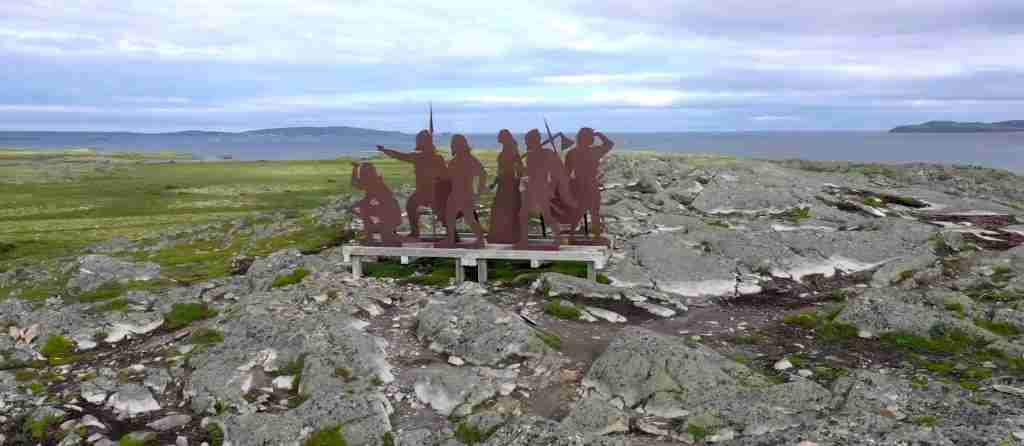
Modern interpretation at L’Anse aux Meadows acknowledges Indigenous presence and perspectives alongside Norse history. Parks Canada’s interpretive programs discuss the site’s 6,000-year human history, explaining how successive cultures utilized this coastal location for fishing, hunting, and seasonal resource gathering. Educational materials address Indigenous-Norse contact as documented in sagas while noting the limitations of saga accounts written from European perspectives. The site’s sculpture “Meeting of Two Worlds” by Luben Boykov and Richard Brixel symbolizes the reconnection of separated human migrations, celebrating shared human origins while respecting distinct cultural developments.
Consultation with Indigenous communities forms an important component of ongoing site management and interpretation. Parks Canada engages with Mi’kmaq, Innu, and other Indigenous nations in discussions about site presentation, artifact interpretation, and recognition of Indigenous connections to the landscape. This collaborative approach ensures multiple perspectives inform visitor experiences and acknowledges that L’Anse aux Meadows’ significance extends beyond Norse history to encompass millennia of Indigenous presence and ongoing Indigenous relationships with these ancestral territories.
Visiting the Site: Practical Information
L’Anse aux Meadows National Historic Site occupies a remote location at the northernmost tip of Newfoundland’s Great Northern Peninsula, approximately 435 kilometers north of Deer Lake and 51 kilometers from St. Anthony. This isolation contributes to the site’s dramatic character and authentic sense of remoteness that Norse explorers themselves experienced, though it requires careful trip planning for modern visitors. The site operates seasonally, typically opening from early June through early October when weather conditions permit safe access and comfortable outdoor exploration.
Reaching L’Anse aux Meadows requires commitment to extensive driving through spectacular but undeveloped landscapes. Most visitors fly to Deer Lake Regional Airport, then embark on a five to six-hour drive northward along Route 430, known as the Viking Trail. This scenic highway traverses Gros Morne National Park, passes fishing villages clinging to rocky coastlines, and winds through vast stretches of boreal forest and coastal barrens characteristic of Newfoundland’s northern wilderness. The journey itself offers remarkable scenery including coastal cliffs, tuckamore forests of wind-stunted evergreens, and frequent wildlife sightings including moose, caribou, and marine mammals.
Parks Canada manages L’Anse aux Meadows with admission fees supporting site operations, conservation, and interpretation programs. Adult admission costs approximately CAD $8, with seniors receiving slight discounts and youth under 17 entering free as part of Parks Canada’s initiative to encourage young people to experience Canada’s national heritage. A Parks Canada Discovery Pass, valid for one year at all Parks Canada properties nationwide, offers excellent value for visitors planning to explore multiple sites during their Canadian travels. The pass covers admission to over 80 national parks, national historic sites, and national marine conservation areas across the country.
The Visitor Centre serves as the essential starting point for any visit, providing context crucial for appreciating the archaeological remains outside. The centre houses a remarkable collection of artifacts recovered during excavations, including the famous bronze cloak pin, iron boat rivets, and various domestic items that bring Norse daily life into focus. Detailed exhibits explain Norse Atlantic expansion, archaeological excavation processes, saga connections, and the site’s significance for understanding medieval exploration. An introductory film presents the discovery story and archaeological findings through dramatic visuals and expert commentary. Visitors should allocate at least 45 minutes for the Visitor Centre to fully absorb these comprehensive presentations before proceeding to the outdoor site.
From the Visitor Centre, an accessible boardwalk winds approximately one kilometer through the archaeological zone and reconstructed settlement. The elevated boardwalk protects sensitive archaeological remains while allowing close viewing of the excavated building foundations marked by red posts indicating wall locations. Interpretive panels positioned along the route explain specific structures, archaeological discoveries, and reconstruction processes. The boardwalk crosses Black Duck Brook near the iron-smelting furnace location, one of the most significant archaeological features demonstrating Norse technological capabilities.
The boardwalk culminates at the reconstructed Norse buildings, faithful reproductions built away from original foundations to prevent archaeological impact. Three major structures recreate the great hall, a secondary dwelling, and a workshop using authentic construction techniques, materials, and dimensions documented through excavation. Visitors can enter these buildings to experience Norse architecture firsthand, observing peat-turf wall construction, interior hearth arrangements, and spatial organization. The dim, earth-sheltered interiors effectively convey the challenging living conditions Norse explorers endured during their brief occupation.
During summer months, costumed interpreters animate the reconstructed buildings, demonstrating period crafts, technologies, and daily activities. These skilled interpreters explain Norse textile production, iron smithing, food preparation, and other aspects of Viking Age life while answering visitor questions and providing historical context. The living history presentations prove particularly engaging for families with children, making abstract history tangible through hands-on demonstrations and interactive discussions. Interpretive programs vary by season and staffing availability, with the most comprehensive offerings occurring during July and August peak visitation periods.
The sculpture “Meeting of Two Worlds” stands along the boardwalk route, commemorating the profound historical moment when Norse and Indigenous peoples encountered each other at this location. Created by artists Luben Boykov and Richard Brixel, the sculpture symbolizes humanity’s migration patterns and the reconnection of populations separated for tens of thousands of years. The artwork encourages contemplation of human interconnection and our species’ remarkable capacity for exploration across diverse environments.
Visitors should plan at least three hours for a complete L’Anse aux Meadows experience, allowing adequate time for the Visitor Centre, boardwalk exploration, reconstructed buildings, and interpretive programs. Photography enthusiasts may wish to allocate additional time for capturing the dramatic coastal landscapes, reconstructed architecture, and archaeological features under optimal lighting conditions. The site’s remote location and seasonal operation make timing critical, as services in the surrounding area remain limited outside the brief summer season.
Weather conditions at L’Anse aux Meadows can prove challenging even during summer months. The exposed coastal location experiences strong winds, cool temperatures, and frequent fog regardless of season. Visitors should dress in layers, bring windproof outer garments, and prepare for conditions significantly cooler than inland Newfoundland areas. Comfortable walking shoes with good traction prove essential for navigating the occasionally muddy boardwalk and gravel paths. The site offers limited weather protection beyond the Visitor Centre, so planning flexibility helps accommodate unexpected weather changes.
Accessibility features at L’Anse aux Meadows include wheelchair-accessible routes through the Visitor Centre and along portions of the boardwalk, though some outdoor areas present challenges due to terrain and construction constraints. Visitors with mobility concerns should contact Parks Canada in advance to discuss specific needs and available accommodations. Staff can provide information about accessible routes, viewing areas, and alternative ways to experience the site when physical limitations prevent full boardwalk exploration.
The Visitor Centre and Exhibitions
The L’Anse aux Meadows Visitor Centre, constructed in the 1980s on a hillside overlooking the settlement area, functions as both gateway and interpretive hub for understanding the site’s exceptional significance. The building’s elevated position provides spectacular panoramic views across the archaeological zone, Black Duck Brook, the shallow bay where Norse ships once anchored, and the distant coastline dotted with icebergs during summer months. This commanding perspective allows visitors to comprehend the settlement’s geographic context and strategic location choices before descending to explore the site at ground level.
The centre’s primary exhibition hall presents a comprehensive narrative explaining Norse Atlantic expansion, Viking Age society, exploration motivations, and the L’Anse aux Meadows settlement within this broader historical framework. Large-format panels with dramatic photography and clear graphics trace Norse migration from Scandinavia through Iceland and Greenland to North America, illustrating the stages of westward expansion that culminated at this northernmost tip of Newfoundland. Timeline displays place L’Anse aux Meadows within medieval history, demonstrating that Norse presence in North America occurred during Europe’s feudal period, centuries before Renaissance exploration initiatives that traditionally receive more attention in popular history.
The artifact displays represent the exhibition’s centerpiece, showcasing actual objects recovered during excavations that provide tangible connections to Norse occupants who lived at this location 1,000 years ago. The famous bronze cloak pin occupies pride of place in a specially designed case with lighting and magnification allowing detailed examination of its intricate Norse craftsmanship. This diminutive object carries enormous significance as definitive proof that women accompanied expeditions to L’Anse aux Meadows, fundamentally challenging earlier assumptions about all-male Viking voyages. Interpretive text explains how this dress accessory functioned, its typological connections to Scandinavian examples, and what its presence reveals about Norse exploration sociology.
Iron boat rivets displayed in quantity demonstrate Norse shipbuilding techniques and explain why these particular artifacts provide some of the strongest archaeological evidence for Norse presence. The rivets’ characteristic clinker-built construction, where overlapping wooden planks are fastened with iron rivets, represents technology completely foreign to Indigenous North American boat building traditions that utilized bark, skin, or dugout construction. Exhibit panels illustrate how archaeologists use diagnostic artifacts like these rivets to distinguish Norse from Indigenous archaeological remains with certainty, a critical methodological point for establishing site authenticity.
Stone artifacts including whetstones, hammerstones, and fire-strikers receive detailed interpretation explaining their functions in Norse daily life and technological systems. The jasper fire-strikers from Iceland particularly interest visitors because their sourcing proves direct connections between L’Anse aux Meadows and Iceland despite the settlement’s administration from Greenland. This evidence reveals the complexity of Norse Atlantic networks and demonstrates that expeditions to North America drew personnel, equipment, and supplies from multiple colonies rather than solely from Greenland.
The butternut shells and butternuts constitute perhaps the most significant artifacts on display because they provide botanical proof that Norse occupants traveled extensively south of Newfoundland to temperate regions where these nuts grow. A detailed map shows butternut distribution beginning 700 kilometers south of L’Anse aux Meadows, illustrating the minimum distances Norse explorers sailed beyond their base camp. This evidence validates saga accounts of expeditions to grape-growing regions, supporting identification of L’Anse aux Meadows as Straumfjord, the base camp from which voyages to Vinland departed rather than Vinland itself.
Archaeological exhibits explain excavation methodologies, conservation techniques, and interpretive processes that transformed grass-covered mounds into understood Norse structures. Before-and-after photographs document excavation phases, showing how archaeologists carefully removed overlying soil to expose building foundations, post holes, and artifact concentrations. Scale models recreate buildings at various reconstruction stages, illustrating how archaeologists interpret fragmentary remains to understand original appearance and function. These displays demystify archaeological practice while emphasizing the scientific rigor behind conclusions about Norse presence and settlement character.
A detailed scale model of the entire settlement proves invaluable for comprehending site layout, building relationships, and landscape context. This three-dimensional representation shows all eight structures in their original positions along the coastal terrace, allowing visitors to visualize the complete Norse infrastructure before exploring the actual archaeological remains outside. Color-coding distinguishes building functions while labels identify specific structures and explain their uses. The model serves as a planning tool that helps visitors orient themselves before embarking on the boardwalk tour, maximizing comprehension when encountering actual building foundations.
Audiovisual presentations enhance interpretive offerings through dramatic footage, expert interviews, and animations that bring Norse exploration to life. The centre’s main film chronicles the settlement’s discovery by Helge and Anne Stine Ingstad, describes excavation processes, and explains archaeological findings that confirmed Norse presence. Historical reenactment sequences recreate Norse daily activities, sailing voyages, and interactions with North American environments. Expert archaeologists, historians, and Indigenous knowledge keepers provide commentary contextualizing the site within broader narratives of exploration, cultural contact, and human migration patterns. The film’s production quality and engaging storytelling make complex archaeological and historical information accessible to general audiences including children.
Interactive displays invite visitor participation through hands-on activities that deepen understanding. Tactile exhibits allow visitors to handle reproduction artifacts, experiencing the weight and feel of tools, weapons, and domestic implements. Touch-screen stations provide additional information about specific topics, allowing self-directed exploration at individual paces. Children’s activity stations present age-appropriate content through games, puzzles, and creative activities that reinforce learning while maintaining engagement during what could otherwise prove challenging for younger visitors navigating dense historical content.
The Visitor Centre shop offers educational materials, souvenirs, and locally produced crafts that extend the visit experience. Books covering Norse exploration, Viking Age history, and archaeological methodology provide opportunities for deeper learning beyond the visit. Reproductions of Norse artifacts, locally crafted items reflecting Newfoundland’s cultural heritage, and children’s educational materials allow visitors to take tangible reminders of their experience. Purchases support site operations and conservation efforts while contributing to the local economy of surrounding communities.
Reconstructed Buildings and Living History
The reconstructed Norse buildings at L’Anse aux Meadows represent one of the most successful living history programs in North American archaeology, allowing visitors to experience Viking Age architecture and daily life through faithful reproductions built using techniques documented during excavations. Three major structures recreate the great hall, a secondary dwelling, and workshop facilities positioned away from original archaeological remains to prevent impact while providing authentic immersive experiences. These reconstructions underwent meticulous planning based on archaeological evidence, comparative examples from Iceland and Greenland, and experimental archaeology testing construction methods and material performance.
The reconstructed great hall dominates the settlement reproduction, measuring approximately 20 by 16 meters with massive turf walls reaching nearly two meters thick at their base. Visitors approach through a low doorway that requires stooping to enter, immediately experiencing the transition from bright exterior to dim, earth-sheltered interior characteristic of Norse architecture. Eyes adjust gradually to reveal the interior space illuminated by a central hearth and limited natural light from a smoke hole in the turf roof. The hall’s substantial dimensions convey its importance as the settlement’s social and administrative center where leaders coordinated activities, hosted gatherings, and made decisions about exploration strategies.
Construction techniques faithfully reproduce archaeological evidence and Norse architectural traditions. Vertical wooden posts set in trenches create the structural framework, with horizontal beams connecting posts at ground level and roof height. Workers filled wall spaces between posts with layers of peat turf cut from surrounding meadows, creating thick insulating walls that moderate interior temperatures and block wind despite their seeming primitive appearance. The turf walls, while effective insulators, require significant thickness to support themselves and bear roof loads, explaining why Norse buildings sacrifice considerable interior space to structural necessities. Visitors gain immediate appreciation for the labor investment constructing these buildings demanded, as calculations indicate 70 to 90 workers needed one to two months to complete all eight settlement structures.
The interior layout recreates spatial organization documented through excavation. A stone hearth occupies the central position, providing cooking facilities and warmth while serving as the gathering point for social activities. An ember pit beside the hearth demonstrates Norse fire management practices, as these pits allowed fires to be banked overnight, maintaining heat and providing coals for quickly rekindling morning fires without the effort of starting new fires from scratch. Sleeping platforms line the long walls, elevated above cold floor drafts and positioned for maximum warmth from the central hearth. Storage areas occupy corners and end spaces, utilizing less desirable locations for preserving food supplies, tools, and equipment.
The turf roof construction proves particularly impressive when viewed from outside, demonstrating engineering solutions to waterproofing and insulation challenges in subarctic climates. Wooden beams support multiple layers of peat turf laid like shingles with overlapping patterns that shed water away from interior spaces. Grass growing on roof surfaces provides additional waterproofing while creating the grass-covered appearance that helped archaeologists initially identify the site. The substantial roof weight requires robust post-and-beam frameworks, explaining why Norse builders invested considerable effort in selecting large timbers from nearby forests despite the labor involved in felling, transporting, and setting these massive structural elements.
During summer months, costumed interpreters animate the reconstructed buildings through living history programs that demonstrate Norse technologies, crafts, and daily activities. These skilled interpreters possess extensive knowledge of Viking Age material culture, allowing them to answer complex questions while maintaining period character. Dressed in wool tunics, trousers, and aprons reproduced from archaeological textile evidence, interpreters engage visitors in discussions about Norse life, exploration motivations, and adaptations to North American environments while demonstrating practical skills essential for Viking Age survival.
Textile production demonstrations prove particularly popular, as interpreters explain wool processing from sheep to finished cloth. Using reproduction tools including spindle whorls similar to the artifact recovered at L’Anse aux Meadows, interpreters spin raw wool into thread while explaining this time-intensive process essential for creating and repairing clothing in cold climates. Loom demonstrations show how thread becomes fabric through laborious weaving processes requiring weeks of work to produce sufficient cloth for a single garment. These presentations convey the enormous labor investments clothing represented in preindustrial societies, helping modern visitors appreciate technologies and material conditions fundamentally different from contemporary life.
Iron working demonstrations utilize a reproduction furnace similar to the one documented along Black Duck Brook, showing how Norse smiths smelted iron from bog ore deposits. Interpreters explain ore identification, collection processes, roasting to remove impurities, and smelting techniques that extract workable iron from processed ore. When conditions permit, full smelting demonstrations produce actual iron that smiths forge into nails, rivets, or tool components, bringing Norse technological capabilities to life through functional reproductions. These programs emphasize how critical iron production proved for Norse expeditions, as the ability to manufacture and repair iron tools, weapons, and ship components enabled self-sufficient operations far from Greenland supply sources.
Food preparation demonstrations recreate Norse cooking techniques using reproduction ceramic vessels, iron cauldrons, and wooden utensils based on archaeological evidence. Interpreters prepare period-appropriate meals including fish, game meats, and basic breads using ingredients Norse occupants would have accessed at L’Anse aux Meadows. Explanations address food preservation through drying and smoking, essential skills for accumulating winter supplies and provisioning ships for return voyages to Greenland. These culinary programs connect visitors to universal human experiences of daily sustenance while highlighting differences in food availability, preservation technologies, and dietary patterns between medieval and modern societies.
Children particularly engage with living history programs through hands-on activities that make abstract history tangible. Interpreters invite young visitors to try spinning wool, handle reproduction tools and weapons under supervision, and participate in simple craft activities appropriate for various age levels. These interactive experiences create lasting memories while reinforcing learning through kinesthetic engagement that proves more effective than passive observation for many learners. Family groups frequently cite living history programs as visit highlights, noting that interpreter enthusiasm and knowledge significantly enhance appreciation for Norse achievements and daily life challenges.
The secondary dwelling and workshop reconstructions provide additional context for understanding settlement organization and functional differentiation. The smaller dwelling shows how less elaborate accommodations housed workers or crew members of lower status, with simpler interior arrangements and reduced floor space compared to the great hall. The workshop reproduction demonstrates specialized activity areas where tool manufacture, hide processing, and other productive tasks occurred separately from residential spaces. These functional distinctions reveal social hierarchies and activity organization within Norse settlements, showing that even temporary base camps maintained structured spatial patterns reflecting Viking Age social organization.
Photography and Seasonal Landscapes
L’Anse aux Meadows offers exceptional photographic opportunities throughout the operating season, with dramatic coastal landscapes, authentic Norse architecture, and remarkable light conditions combining to create images that capture both historical and natural significance. The site’s remote location at Newfoundland’s northern extremity means photographers encounter relatively pristine environments with minimal modern intrusions visible in most compositions, allowing period-appropriate images emphasizing the windswept, isolated character Norse explorers themselves experienced.
The coastal setting provides endless compositional possibilities, from wide vistas showing the entire settlement area against the backdrop of sea and sky to intimate details of reconstructed buildings, archaeological features, and native vegetation. The shallow bay where Norse ships once anchored reflects changing sky conditions, creating mirror images during calm periods and dramatic wave action when winds blow. Icebergs drifting past the site during June and July add spectacular foreground or background elements unique to subarctic regions, their massive white forms contrasting beautifully against green meadows and dark ocean waters.
Light quality at northern latitudes produces distinctive effects prized by photographers. Summer’s extended daylight hours mean morning golden hour arrives early and evening golden hour lasts remarkably long, providing multiple daily opportunities for warm, directional light that emphasizes landscape textures and architectural details. The high-latitude sun angle creates different shadow patterns compared to locations farther south, with longer, more dramatic shadows enhancing three-dimensionality in landscape compositions. Overcast conditions, frequent at coastal locations, produce even, diffused light ideal for detail photography and capturing the moody atmospheres often associated with Norse historic sites.
The reconstructed buildings photograph beautifully from multiple angles, with their grass-covered turf construction creating organic forms that blend naturally with surrounding meadows. The buildings’ substantial scale and distinctive architecture make them immediately recognizable as Norse structures, requiring minimal context to convey historical character. Interior photography presents technical challenges due to limited natural light, but successful images effectively convey the dim, earth-sheltered environments Norse occupants inhabited. Flash photography, when permitted, reveals interior details including hearth arrangements, sleeping platforms, and structural elements otherwise difficult to capture.
Archaeological features along the boardwalk route offer opportunities for documentary-style photography showing actual Norse building foundations marked by red posts. These images effectively communicate the archaeological reality underlying reconstructions, helping viewers understand that faithful reproductions rest on solid scientific evidence rather than speculation. Wide-angle compositions showing boardwalk routes through the settlement area provide context for understanding site scale and organization, while telephoto compression emphasizes relationships between building complexes along the coastal terrace.
Seasonal changes dramatically affect photographic opportunities and site character. Early season visits in June encounter landscapes emerging from winter dormancy, with grasses beginning their growth cycle and wildflowers initiating bloom. Lingering icebergs prove most numerous during this period, though unpredictable fog can challenge photography. July and August bring peak vegetation growth, transforming meadows into lush green expanses dotted with colorful wildflowers including lupines, irises, and Arctic cotton. These months offer the most reliable weather and fullest interpretive programs, though increased visitation means more people appear in site photographs.
September delivers exceptional fall colors as vegetation transitions toward dormancy, with meadow grasses turning golden and surrounding forests displaying autumn foliage. The changing season creates remarkably vibrant color palettes, from warm grass tones to brilliant red and orange foliage against dark evergreen backgrounds and blue ocean waters. Visitor numbers decline substantially after Labour Day, providing opportunities for photography without crowds while weather remains generally favorable. Early season closures mean timing proves critical for fall photography, as the site typically ceases operations in early October.
Weather conditions contribute significantly to photographic character and emotional impact. Fog rolling across the site creates mysterious, atmospheric images emphasizing the location’s remote, windswept nature. Storm clouds building over the ocean produce dramatic skies that enhance landscape compositions with dynamic elements and tonal contrasts. Even rain, while challenging for equipment protection, creates moody conditions and saturated colors that effectively convey the harsh environmental conditions Norse explorers endured. Photographers willing to brave uncomfortable weather often capture the most compelling images that transcend typical tourist documentation.
Wildlife photography opportunities exist throughout the site and surrounding areas, with moose, caribou, Arctic hares, and various seabirds inhabiting the region. Marine mammals including whales occasionally appear in coastal waters visible from the site, particularly during summer months when various species migrate through northern Newfoundland waters. Bird photography proves particularly rewarding, as numerous species nest in the area or pass through during migration periods. The meadow and coastal habitats support diverse avian communities that add life and movement to landscape compositions.
Drone photography, subject to Parks Canada regulations and permit requirements, provides spectacular aerial perspectives showing site layout, building relationships, and landscape context impossible to convey through ground-level photography. Overhead views effectively communicate how Norse builders positioned structures along the coastal terrace, oriented buildings to prevailing winds, and selected locations providing both resource access and defensive advantages. Aerial images also reveal archaeological features and settlement patterns difficult to perceive at ground level, offering insights valuable for both artistic and documentary purposes.
Photographers should respect site regulations protecting archaeological remains and visitor experiences. Tripod use generally requires no special permits but should avoid blocking boardwalk routes or interfering with guided tours and interpretive programs. Commercial photography may require advance permission and potentially fees supporting site operations. Drone operators must obtain Parks Canada authorization and observe altitude, distance, and operational restrictions protecting visitor safety and site integrity. Photographers working with models or conducting elaborate productions should contact Parks Canada well in advance to discuss requirements and scheduling that minimizes impact on regular visitation.
Conservation and Ongoing Research
Conservation at L’Anse aux Meadows employs sophisticated strategies balancing preservation of irreplaceable archaeological remains with public access and interpretation essential for fulfilling the site’s educational mission. Following complete excavation and documentation of Norse building foundations, Parks Canada implemented controlled reburial using techniques that protect remains from deterioration while preserving evidence for future research as technologies advance. This approach recognizes that reburying excavated features in stable, monitored conditions often provides better long-term preservation than attempting to stabilize and display fragile remains exposed to weathering, biological activity, and human interference.
The reburial strategy involves carefully covering excavated foundations with geotextile fabrics that prevent mixing of protective fill with original archaeological deposits while allowing water drainage. Clean sand and gravel layers provide additional protection and drainage before final covering with topsoil that supports vegetation growth similar to surrounding meadows. This multi-layer approach creates stable conditions minimizing oxygen exposure and biological activity that would otherwise degrade organic remains, metal artifacts, and structural timbers preserved in the peat. Monitoring systems track moisture levels, temperature fluctuations, and settling patterns, allowing Parks Canada to identify and address any conservation concerns before serious deterioration occurs.
The decision to reconstruct Norse buildings away from original foundations demonstrates commitment to archaeological preservation over convenience or dramatic presentation. While positioning reconstructions directly atop excavated remains would create more immediate visual connections, the physical impact from construction activities, visitor traffic, and structural loading would inevitably damage irreplaceable archaeological deposits. The current arrangement preserves original remains intact while providing authentic architectural experiences through scientifically grounded reconstructions that serve interpretation without compromising preservation.
Artifact conservation presents distinct challenges requiring specialized expertise and facilities. Organic materials including wood, textiles, and bone deteriorate rapidly when exposed to oxygen after centuries in stable, anaerobic peat conditions. The bronze cloak pin, while relatively stable, required gentle cleaning to remove corrosion products without damaging delicate surface details. Iron artifacts, particularly susceptible to corrosion, undergo stabilization treatments that halt degradation and consolidate fragile metal structures. Artifacts selected for public display in the Visitor Centre occupy carefully controlled environments with regulated temperature, humidity, and light levels minimizing ongoing deterioration.
Parks Canada employs professional conservators who monitor artifact conditions, implement preventive conservation measures, and conduct interventive treatments when necessary. Regular condition assessments document any changes requiring attention, allowing proactive responses before serious damage occurs. Some artifacts undergo periodic rotation between display and storage, limiting light exposure while ensuring the most significant pieces remain available for public viewing. This balanced approach maintains interpretation quality while protecting collections for future generations.
Ongoing research continues revealing new insights about Norse presence, settlement chronology, and relationships to broader Atlantic exploration networks. Non-invasive investigation techniques including ground-penetrating radar, magnetic surveys, and systematic surface collection search for additional Norse structures or artifacts without disturbing preserved remains. These surveys periodically identify anomalies warranting further investigation, though major new discoveries remain unlikely given the intensive excavations conducted during the 1960s-1970s. Research focus has shifted toward refining understanding of known features rather than discovering entirely new settlement areas.
Landscape archaeology examines how Norse settlers interacted with surrounding environments, exploited resources, and adapted to subarctic conditions dramatically different from Greenland or Iceland. Studies analyze pollen sequences documenting vegetation changes potentially related to Norse activities, investigate bog iron deposits utilized for smelting, and examine salmon stream productivity supporting Norse subsistence strategies. This research contextualizes the settlement within its environmental setting, revealing how Norse explorers assessed landscapes, identified exploitable resources, and organized resource extraction supporting their brief occupation.
Comparative research connects L’Anse aux Meadows to other Norse Atlantic sites, examining similarities and differences in architecture, artifact assemblages, and settlement patterns. Detailed comparisons with Greenland sites reveal how expeditions adapted building techniques, modified resource exploitation strategies, and adjusted social organization for temporary base camp functions versus permanent agricultural settlements. These studies illuminate Norse flexibility and adaptive capabilities essential for successful exploration in unfamiliar environments lacking the livestock, familiar crops, and established trade networks supporting Greenland colonies.
Interdisciplinary research teams combine archaeological evidence with saga analysis, historical climatology, oceanography, and Indigenous oral traditions to create comprehensive understanding of Norse exploration context. Climate reconstructions document environmental conditions during the settlement period, revealing warmer temperatures and different ice distributions than modern patterns. Ocean current studies model sailing routes and navigation challenges Norse explorers faced during transatlantic voyages. Integration of Indigenous knowledge contributes perspectives on regional ecology, seasonal patterns, and cultural landscapes that Norse explorers encountered, enriching interpretation beyond purely Norse viewpoints.
Modern DNA analysis of artifact residues investigates questions about Norse diet, domestic activities, and resource use through microscopic organic traces. Advanced dating techniques refine chronologies, potentially distinguishing multiple occupation episodes or clarifying relationships between different structures. Materials analysis identifies artifact sourcing, tracing iron to specific bog deposits, stone tools to particular quarries, and organic materials to origin regions. These scientific approaches extract maximum information from limited archaeological evidence, demonstrating how modern technologies reveal insights impossible to obtain through excavation alone.
Public archaeology programs engage local communities and visitors in ongoing research, fostering stewardship and creating opportunities for experiential learning. Experimental archaeology projects test reconstruction techniques, evaluate material performance, and investigate Norse technological capabilities through hands-on reproduction and use. These projects inform interpretation while generating research data about construction requirements, labor investments, and functional characteristics difficult to infer from archaeological remains alone. Community involvement in these experiments builds local connections to the site while creating skilled interpreters who bring authentic knowledge to living history programs.
International collaborations with scholars from Norway, Iceland, Greenland, and other Norse heritage countries ensure L’Anse aux Meadows research incorporates global expertise and comparative perspectives. Joint projects examine transnational research questions about Norse Atlantic expansion, colonial strategies, and cultural adaptations across diverse environments. These partnerships facilitate artifact comparisons, architectural analyses, and synthetic studies placing L’Anse aux Meadows within the broader narrative of Viking Age exploration and settlement that spanned from Scandinavia to North America.
Frequently Asked Questions
How do archaeologists know L’Anse aux Meadows was built by Vikings and not by Indigenous peoples?
Multiple lines of conclusive archaeological evidence confirm Norse construction at L’Anse aux Meadows beyond any reasonable doubt. The building construction techniques employ vertical wooden posts supporting peat-turf walls, an architectural method characteristic of Norse settlements in Iceland and Greenland but completely unknown to Indigenous North American cultures. The distinctive clove-shaped bronze cloak pin represents a specifically Norse dress accessory worn by Viking Age women throughout Scandinavia and Norse Atlantic colonies, with identical examples excavated from confirmed Norse sites in Iceland, Greenland, and Scandinavia itself. The 99 iron boat rivets recovered during excavations demonstrate clinker-built ship construction where overlapping wooden planks are fastened with iron rivets, a shipbuilding technology exclusive to Norse traditions and foreign to Indigenous boat construction using bark, skin, or dugout techniques. The iron-smelting furnace represents advanced metallurgical technology practiced by Norse smiths but absent from Indigenous North American technological repertoires until European contact. The soapstone spindle whorl indicates wool spinning for textile production using sheep wool, as Indigenous peoples did not possess domesticated sheep and employed different fiber processing technologies. Radiocarbon dating consistently places occupation around the year 1000, precisely when saga accounts describe Norse voyages to North America. The artifact assemblage, construction methods, chronology, and technological signatures collectively provide overwhelming evidence that only Norse colonists from Greenland could have established this settlement, eliminating any possibility of Indigenous construction or later European presence.
Why did Vikings abandon L’Anse aux Meadows after only three years?
Archaeological and saga evidence suggests multiple interconnected factors contributed to Norse abandonment of L’Anse aux Meadows after approximately three years of occupation. Conflicts with Indigenous populations, documented in saga accounts and possibly evidenced by defensive site layouts, posed serious security threats to the relatively small Norse groups operating far from Greenland reinforcements. The sagas describe violent encounters resulting in Norse casualties, encounters that convinced leaders that permanent colonization against hostile Indigenous populations vastly outnumbering the few hundred available Greenland colonists proved impractical and unsustainable. The site’s environmental limitations made it unsuitable for large-scale Norse agricultural practices, as the brief growing season, limited arable land, and marginal soils could not support the livestock-based farming economy central to Norse colonial success in Iceland and Greenland. The settlement appears to have functioned primarily as a base camp for exploration and resource extraction rather than an agricultural colony, suggesting Norse leaders intended only temporary occupation from the start. The enormous logistical challenges of maintaining regular contact with Greenland across 2,000 kilometers of dangerous North Atlantic waters, combined with limited economic returns compared to risks and resource investments, likely convinced Norse leaders that sustained North American presence exceeded their capabilities. Evidence of only three years’ occupation, including minimal artifact accumulation, limited building wear, and absence of burials, indicates planned withdrawal rather than catastrophic abandonment. Norse interests apparently shifted toward safer, more profitable resource extraction from Labrador forests, which required less infrastructure and avoided sustained Indigenous conflicts while still providing valuable timber for Greenland’s resource-poor economy. The abandonment demonstrates pragmatic Norse assessment that North American colonization exceeded their demographic and economic capacity, leading to strategic withdrawal that preserved limited Norse resources for more sustainable enterprises.
What happened to the Norse artifacts found at L’Anse aux Meadows?
The artifacts recovered during excavations at L’Anse aux Meadows underwent careful conservation treatment and remain in Canadian custody, with the most significant pieces displayed in the site’s Visitor Centre while additional materials reside in Parks Canada conservation facilities and research collections. During the Ingstads’ initial excavations from 1961 to 1968, all artifacts were documented, catalogued, and conserved according to archaeological standards, with detailed records preserving findspot locations and contextual information essential for research. The Canadian government negotiated with the Ingstads to ensure artifacts remained in Canada as national heritage objects rather than being exported to Norway, recognizing their significance for Canadian history and their UNESCO World Heritage context. The bronze cloak pin, iron boat rivets, soapstone spindle whorl, and other diagnostic Norse artifacts occupy prominent positions in the Visitor Centre’s exhibition, displayed in climate-controlled cases with appropriate lighting and security protecting these irreplaceable objects. Conservation treatments stabilized corroded iron artifacts, cleaned the bronze pin without damaging surface details, and consolidated fragile organic materials to prevent further deterioration. Some artifacts undergo periodic rotation between display and secure storage to limit cumulative light exposure while ensuring the most important pieces remain available for public viewing and educational purposes. Research access to the complete artifact collection remains available to qualified scholars conducting legitimate research on Norse exploration, Viking Age material culture, or archaeological methodology, with requests managed through Parks Canada’s research permit system. The artifact assemblage serves as the permanent, scientifically documented evidence base supporting interpretations of Norse presence, settlement function, and technological capabilities presented in the site’s interpretive programs. Modern non-destructive analysis techniques including x-ray fluorescence, microscopy, and DNA analysis continue extracting new information from these artifacts without consuming or damaging the original materials, demonstrating how collections remain valuable for research long after initial excavation and study.
Are there other Viking settlements in North America besides L’Anse aux Meadows?
L’Anse aux Meadows remains the only archaeologically verified Norse settlement in North America outside Greenland, despite numerous investigations seeking additional sites and periodic claims of Viking presence at various locations. Saga accounts clearly describe voyages to regions south of L’Anse aux Meadows where Norse explorers encountered grapes, superior timber, and milder climates, strongly suggesting additional Norse infrastructure existed in areas like New Brunswick or the Gulf of St. Lawrence. However, no definitive archaeological evidence has confirmed any other Norse settlements in North America despite extensive searches and investigation of promising locations. The butternut evidence at L’Anse aux Meadows proves Norse presence 700 kilometers south in temperate zones, but whether this presence involved temporary camps, seasonal resource extraction stations, or more substantial settlements remains archaeologically undemonstrated. Several sites have generated initial excitement before investigation revealed non-Norse origins, including the Kensington Runestone in Minnesota (determined to be a modern forgery), various stone structures in New England (built by colonial-era farmers), and supposed Norse artifacts that proved to be either Indigenous objects misidentified or outright fabrications. A site at Point Rosee in southern Newfoundland generated significant media attention in 2016 after satellite imagery and preliminary investigation suggested possible Norse features, but subsequent excavation by archaeologists determined the supposed Norse activity represented natural bog iron deposits and medieval Indigenous ironworking unrelated to Norse presence. The Maine Penny, a genuine Norwegian coin from the reign of Olaf Kyrre found at an Indigenous archaeological site in Maine, demonstrates Norse trade goods reached considerable distances from any Norse settlement, but provides no evidence of Norse infrastructure or permanent presence in that region. Labrador’s northern coast shows clear evidence of sustained Norse presence for timber harvesting, with documentary sources describing these expeditions into the 14th century, but no settlement infrastructure comparable to L’Anse aux Meadows has been definitively identified. The unique status of L’Anse aux Meadows likely reflects its function as a gateway settlement from which expeditions departed for resource-rich southern regions that were visited seasonally or temporarily but never received permanent Norse infrastructure. Archaeological discovery of additional Norse sites remains entirely possible and would dramatically enhance understanding of Norse North American presence, but as of now, L’Anse aux Meadows stands alone as proven Norse settlement, making its preservation and interpretation critically important for documenting this remarkable chapter in exploration history.
Can you visit L’Anse aux Meadows in winter?
L’Anse aux Meadows National Historic Site operates seasonally from approximately early June through early October, closing during winter months when severe weather conditions, snow accumulation, and frigid temperatures make site access unsafe and interpretation impossible. The remote northern location experiences harsh winter conditions including heavy snowfall, sub-zero temperatures regularly reaching minus 20 degrees Celsius or lower, and powerful winds that create dangerous wind chill factors. The site’s boardwalk routes become impassable under snow cover, while the reconstructed Norse buildings would be inaccessible and potentially damaged by visitor traffic during winter conditions. Parks Canada staff vacate the site during winter closure, meaning no interpretation services, emergency assistance, or facility maintenance occurs outside the operating season. The Visitor Centre closes completely, securing artifacts and exhibits against winter conditions while eliminating heating costs for an unoccupied facility. The surrounding communities at Newfoundland’s northern tip experience significant population decline during winter as seasonal tourism workers depart and fishing activities cease, meaning limited services exist in the region even if someone reached the area. Winter road conditions along Route 430 can prove extremely challenging, with frequent closures due to blizzards, ice, and drifting snow making the already lengthy drive from southern Newfoundland potentially dangerous or impossible. The brief daylight hours during winter months, combined with frequent storms and overcast conditions, would eliminate photography opportunities and create dismal visiting conditions even if site access were somehow possible. While some visitors might imagine experiencing the site under winter conditions similar to those Norse occupants endured, the reality involves significant safety risks without corresponding benefits, as interpretation and understanding suffer when key features remain hidden under snow. Visitors planning L’Anse aux Meadows trips should schedule visits between June and September for optimal conditions, with July and August offering the most reliable weather, fullest interpretive programs, and longest daylight hours. Early season visits in June benefit from potential iceberg viewing and fewer crowds but risk encountering cool, foggy conditions. September provides beautiful fall colors and reduced visitation but faces unpredictable weather and early-season closures. Anyone considering visiting should verify operating dates directly with Parks Canada before finalizing travel plans, as opening and closing dates vary annually based on weather conditions and operational considerations.
How difficult is it to reach L’Anse aux Meadows?
Reaching L’Anse aux Meadows requires significant commitment to extensive travel through remote regions, making it one of the most challenging UNESCO World Heritage Sites to visit in North America. Most visitors fly to Deer Lake Regional Airport in western Newfoundland, then face a 435-kilometer drive northward along Route 430, the Viking Trail, requiring approximately five to six hours of driving time under good conditions. This highway traverses Gros Morne National Park’s spectacular but undeveloped landscapes, passes through small fishing villages with limited services, and winds through vast stretches of boreal forest and coastal barrens where cell phone coverage proves unreliable or nonexistent. The road quality varies, with some sections well-maintained while others show potholes, frost heaving, and deterioration common in northern regions with harsh freeze-thaw cycles. Wildlife hazards, particularly moose and caribou, create serious collision risks requiring constant vigilance, especially during dawn and dusk periods when animals are most active. Gas stations become increasingly infrequent north of Gros Morne National Park, necessitating careful fuel planning to avoid being stranded without services. Accommodation options along the route remain limited outside peak summer season, requiring advance reservations to secure lodging in the few communities offering tourist facilities. The journey’s length and remoteness mean visitors should plan at least two days minimum for the round-trip drive, with most itineraries requiring three to four days to allow adequate time at L’Anse aux Meadows itself plus stops at Gros Morne and other attractions along the Viking Trail. Alternative access via St. Anthony Airport offers flights from St. John’s, reducing drive time to approximately 50 kilometers, but flight schedules and aircraft sizes remain limited, making this option expensive and potentially unreliable due to weather cancellations. Public transportation to L’Anse aux Meadows does not exist, making personal vehicle rental essential unless joining organized tour groups that include the site in multi-day itineraries departing from major Newfoundland cities. The site’s remoteness contributes significantly to its authentic character and preservation as a relatively pristine landscape, but visitors must realistically assess their willingness to undertake substantial travel commitment reaching this isolated location. For those willing to invest the time and effort, the journey itself offers remarkable scenery, dramatic coastal landscapes, and authentic experiences of Newfoundland’s rugged northern wilderness that enhance appreciation for Norse explorers’ achievements in reaching and settling this remote extremity 1,000 years ago.
What is the best time of year to visit L’Anse aux Meadows?
The optimal visiting period for L’Anse aux Meadows spans July and August when weather conditions prove most reliable, interpretive programs operate at full capacity, and daylight hours extend longest for outdoor exploration. These peak summer months offer the warmest temperatures, though “warm” remains relative at northern latitudes where daily highs typically reach only 15-20 degrees Celsius with cool evenings requiring layers even during peak summer. July and August provide the most consistent access to costumed interpreters demonstrating Norse crafts and technologies in reconstructed buildings, guided tours explaining archaeological discoveries, and special programming that brings the site’s history to life through engaging presentations. Wildflowers reach peak bloom during this period, transforming meadows into colorful displays featuring lupines, irises, pitcher plants, and Arctic cotton that create beautiful photographic subjects complementing the architectural and archaeological features. The extended daylight hours characteristic of northern latitudes mean morning golden hour arrives remarkably early and evening golden hour extends well into late evening, providing multiple daily opportunities for photography under optimal lighting conditions. However, July and August also bring the highest visitor numbers, potentially creating crowded conditions at peak times when multiple tour groups converge on the relatively compact site. June offers compelling advantages for visitors seeking fewer crowds and potential iceberg viewing, as massive ice formations drift past the coast during late spring and early summer before melting or moving northward. Icebergs create spectacular photographic subjects and unforgettable visual experiences, though their presence remains unpredictable and cannot be guaranteed. June weather proves more variable than July-August, with increased fog potential, cooler temperatures, and occasional stormy periods that may limit outdoor activities. Early September delivers exceptional conditions for visitors prioritizing photography and solitude, as dramatic fall colors transform meadow grasses to golden tones and surrounding forests display brilliant autumn foliage. The changing season creates vibrant color palettes particularly effective in landscape photography, while substantially reduced visitor numbers after Labor Day mean experiencing the site with minimal crowds. Weather reliability declines in September compared to summer months, with increased probability of storms, fog, and cool conditions that may affect comfort and photography opportunities. The site typically closes in early October as winter approaches, making late September visits risky if adverse weather forces early closure. Visitors with flexible schedules should monitor weather forecasts and be prepared to adjust plans, as conditions at exposed coastal locations can change rapidly regardless of season. The worst visiting period runs from late October through May when the site remains closed, winter conditions prevail, and accessing the region becomes extremely challenging and potentially dangerous.
Is L’Anse aux Meadows the Vinland mentioned in Viking sagas?
L’Anse aux Meadows most likely represents Straumfjord, the base camp described in Erik the Red’s Saga from which Norse explorers ventured south to Vinland proper rather than being Vinland itself. This interpretation rests on multiple lines of evidence distinguishing base camp functions from destination characteristics. The saga describes Straumfjord as a location with strong tidal currents providing protected anchorage where ships could be beached for repairs, characteristics matching L’Anse aux Meadows precisely. The settlement’s modest size, brief three-year occupation, absence of agricultural infrastructure, and concentration of boat repair and iron production activities all indicate temporary base camp rather than the resource-rich destination worth the name Vinland. The butternut evidence provides the most compelling argument distinguishing L’Anse aux Meadows from Vinland, as these nuts grow only 700 kilometers south in temperate zones, proving occupants traveled extensively beyond their northern base to regions with warmer climates. The saga’s description of Vinland emphasizes abundant wild grapes, superior timber resources, and milder climate where livestock could winter outdoors without fodder, characteristics completely absent from L’Anse aux Meadows’ subarctic environment where no grapes grow and winter conditions rival Greenland’s harshness. Vinland almost certainly refers to regions in New Brunswick, the Gulf of St. Lawrence, or potentially as far south as New England, all areas within feasible sailing range from L’Anse aux Meadows where grapes grew, hardwood forests provided superior timber, and milder climates matched saga descriptions. The name “Vinland” itself may derive from “vínber” meaning grapes or wine berries, or alternatively from “vin” meaning meadow or pasture, with scholarly debate continuing about original meaning and geographic reference. Archaeological evidence suggests Vinland functioned as a general term encompassing multiple resource-rich locations along the North American coast that Norse explorers accessed from their L’Anse aux Meadows base. The saga accounts likely conflate multiple voyages, combine distinct locations into composite descriptions, and compress complex exploration patterns into simplified narratives serving literary purposes rather than precise geographic documentation. Understanding L’Anse aux Meadows as Straumfjord, the gateway to Vinland, resolves apparent contradictions between saga descriptions of grape-growing regions and the archaeological reality of a subarctic settlement where grapes cannot grow. This interpretation explains why Norse explorers established infrastructure at this northern location despite its harsh climate and limited agricultural potential: the site provided strategic access to warmer southern regions, protected anchorage for ship maintenance, iron production capabilities from local bog deposits, and a secure base from which expeditions could safely operate. The distinction between base camp and destination helps explain brief occupation, as once explorers realized permanent colonization faced insurmountable challenges from Indigenous resistance and logistical constraints, they withdrew to Greenland while potentially continuing seasonal resource extraction that required no permanent infrastructure.
What did Norse explorers hope to find in North America?
Norse expeditions to North America sought specific material resources unavailable or scarce in Greenland that would enhance colonial economy and quality of life while potentially opening new settlement territories. Timber represented the most critical resource motivating exploration, as Greenland possessed virtually no forest resources beyond limited scrub willow and dwarf birch useless for construction or shipbuilding. Norse colonists required substantial timber quantities for building maintenance, ship repairs, and replacement vessel construction, with all significant timber necessarily imported either from Norway at great expense or harvested from Labrador forests through dangerous expeditions. The discovery of vast North American forests promised unlimited timber supplies of superior quality closer to Greenland than Norwegian sources, potentially revolutionizing colonial economy by eliminating expensive European imports. Iron ore represented another critical resource, as Greenland’s bog iron deposits provided only limited quantities of relatively poor-quality ore requiring extensive processing. The discovery of North American bog iron deposits accessible for smelting meant expeditions could produce iron tools, nails, and ship components locally, reducing dependence on European imports while supporting self-sufficient operations. Wild grapes discovered in southern regions offered potential for wine production, a culturally significant beverage in medieval Christian society that Norse Greenlanders otherwise imported from Europe at prohibitive cost. The saga emphasis on grape discoveries suggests Norse explorers recognized significant economic and social value in viticulture potential, even if actually establishing vineyards proved impractical given other constraints. Superior hardwood timber from temperate forests provided materials for specialized construction, shipbuilding components, and trade goods potentially valuable in European or Icelandic markets. Furs from North American fur-bearing animals represented valuable trade commodities, particularly high-quality pelts unavailable in Greenland or Iceland that could be sold in European markets for substantial profits. Walrus ivory from northern regions provided another valuable export commodity supporting Greenland’s economy, with North American walrus populations offering additional harvesting opportunities. New agricultural lands potentially suitable for Norse farming practices represented long-term colonization opportunities that could relieve population pressure on Greenland’s limited productive land. The saga descriptions of Vinland emphasize abundant resources, mild climate, and land where livestock could winter outdoors, all characteristics suggesting regions far superior to Greenland’s marginal agricultural conditions. Norse explorers also sought prestige and reputation enhancement through discovery achievements, as successful exploration brought social status, saga commemoration, and historical recognition highly valued in Norse society. The combination of practical resource acquisition and cultural prestige motivations drove Norse exploration across the North Atlantic, with North America representing the ultimate western frontier offering both material benefits and heroic accomplishment opportunities. The eventual Norse withdrawal despite these attractive resources demonstrates that practical constraints including Indigenous resistance, logistical challenges, limited demographic capacity, and economic sustainability concerns ultimately outweighed motivations, leading to abandonment of permanent settlement attempts while possibly continuing limited seasonal resource extraction from safer northern regions.
How did Vikings navigate to North America without modern technology?
Norse navigators employed sophisticated celestial observation, natural phenomena interpretation, and accumulated geographical knowledge enabling consistent transatlantic voyages without magnetic compasses or mechanical navigation instruments. The fundamental Norse navigation system relied on latitude sailing, where navigators would travel north or south along known coastlines until reaching the latitude of their destination, then turn east or west maintaining that latitude until landfall. This technique required accurate latitude determination, which Norse sailors accomplished through careful observation of the sun’s midday altitude using simple tools and accumulated experience. The Norse probably used a bearing dial or sun compass, a circular wooden disc with a center peg casting shadows that navigators marked at specific times, allowing approximate latitude determination by comparing shadow lengths to known reference points. Latitude sailing enabled Norse navigators to reliably cross the North Atlantic between Norway, Iceland, Greenland, and North America by maintaining consistent latitudes where destinations lay directly east or west along the sailing route. The voyage from Greenland to Newfoundland particularly suited this technique, as both locations lie at similar latitudes enabling relatively straightforward west-bearing courses that intersected with North American coasts after approximately 2,000 kilometers of open ocean sailing. Norse sailors developed detailed mental charts incorporating geographical features, coastal profiles, sea conditions, wildlife patterns, and astronomical observations that accumulated through generations of exploration and experience. The sagas describe recognizing specific landmarks, navigating by known island chains, and following traditional routes refined through repeated voyages that reduced uncertainties and established proven sailing strategies. Norse ships possessed remarkable seaworthiness and sailing performance enabling Atlantic crossings despite adverse conditions. The clinker-built construction with overlapping planks created flexible hulls that could withstand North Atlantic storms, while sophisticated rigging allowed sailing close to the wind when necessary. These vessels combined seaworthiness with the shallow draft needed for beaching and repairs in locations without harbor facilities. Natural navigation cues supplemented celestial observations, including ocean current patterns, water temperature changes, characteristic wave formations, driftwood origins, seabird flight directions, and whale migration routes that indicated proximity to land or helped maintain courses. Experienced Norse navigators recognized these subtle indicators and incorporated them into navigation strategies that reduced dependence on celestial observations during periods of overcast weather common in North Atlantic regions. The Iceland-Greenland crossing, established decades before North American voyages, provided essential experience in open-ocean navigation out of sight of land for extended periods. Navigators learned to maintain courses across 500 kilometers of open water between Iceland and Greenland’s east coast, developing skills and confidence applicable to longer North American crossings. The Greenland-Newfoundland crossing of approximately 2,000 kilometers represented the longest open-ocean Norse voyage, though prevailing current patterns and wind directions generally favored westward crossings while making return voyages more challenging. Norse willingness to undertake these crossings demonstrates remarkable seafaring courage and navigational confidence supported by generations of accumulated Atlantic sailing experience. Some scholars suggest Norse navigators may have possessed calcite crystals serving as “sunstones” that reveal the sun’s position during overcast conditions by exploiting polarized light patterns, though evidence for this practice remains debated and controversial. Successful navigation relied fundamentally on accumulated knowledge, careful observation, experience-based judgment, and Norse cultural emphasis on seafaring excellence that produced highly skilled navigators capable of remarkable oceanic crossings without modern technological assistance.
Why is L’Anse aux Meadows important for Canadian history?
L’Anse aux Meadows fundamentally changed understanding of Canadian history by providing physical evidence that humans of European origin inhabited Canadian territory 500 years before traditionally recognized European arrival dates based on Cabot’s 1497 voyage or Cartier’s 1534-1535 expeditions. This historical revision emphasizes that North American history encompasses far more complex patterns of exploration, contact, and cultural interaction than simplified narratives of continuous European colonial expansion beginning in the late 15th century. The site documents sophisticated transatlantic voyaging capabilities during the medieval period, challenging assumptions that only post-Renaissance European societies possessed the maritime technologies, navigational knowledge, and organizational capacity for sustained oceanic exploration. L’Anse aux Meadows demonstrates that Norse Atlantic expansion represented a genuine colonial movement establishing European communities across 4,000 kilometers of ocean from Norway to North America, creating interconnected settlements that functioned as an integrated cultural sphere. The archaeological evidence shows that Europeans encountered Indigenous North American societies 500 years before traditionally recognized first contact, raising important questions about possible cultural exchanges, knowledge transmission, and the impacts of these early encounters on both populations. The site’s significance extends beyond simply documenting Norse presence to illuminating the precarious nature of colonial enterprises, as the settlement’s brief three-year occupation and subsequent abandonment reveals the challenges of maintaining distant colonies against environmental constraints, Indigenous resistance, and limited demographic resources. This historical lesson resonates strongly with Canadian historical experience, where European colonial projects frequently struggled against harsh environments, resource limitations, and conflicts with Indigenous peoples defending territories. L’Anse aux Meadows provides tangible connection to saga literature, transforming medieval Icelandic narratives from potentially fictional tales into historically verified accounts with corresponding physical evidence. This validation demonstrates how archaeological investigation and textual sources complement each other, revealing historical realities through material remains while recognizing limitations in literary evidence subject to embellishment and narrative conventions. The site’s UNESCO World Heritage designation brought international recognition to Canadian heritage, placing a remote Newfoundland location in the same prestigious category as global landmarks including the Pyramids, Taj Mahal, and Great Wall of China. This recognition enhances Canadian cultural prestige and identity while attracting international visitors contributing to regional economies. L’Anse aux Meadows encourages reflection on Indigenous-European relations throughout Canadian history, as the saga accounts of conflicts between Norse explorers and Indigenous peoples foreshadow patterns that would recur dramatically during later European colonization. Understanding these early encounters provides context for analyzing how cultural contact unfolded, how technological advantages proved insufficient against determined Indigenous resistance, and how colonial success required accommodations and relationships beyond simple military superiority. The site preserves Newfoundland’s connection to global exploration narratives, giving Canada’s easternmost province starring roles in human migration history, transatlantic voyaging, and the story of human expansion across the globe. This historical significance provides cultural identity and pride for Newfoundlanders while establishing their territory as a crucial nexus in world history. For Indigenous Canadians, L’Anse aux Meadows acknowledges their ancestors’ presence predating European arrival by millennia and recognizes Indigenous peoples’ successful resistance to early colonization attempts. The site’s interpretation increasingly incorporates Indigenous perspectives and oral traditions, creating more balanced historical narratives that recognize multiple viewpoints rather than exclusively European-centered stories. L’Anse aux Meadows serves educational purposes throughout Canada, appearing in school curricula, documentary films, and popular media as an accessible introduction to complex historical themes including exploration, cultural contact, archaeological methods, and heritage preservation. The site’s clear physical evidence and dramatic historical story make it particularly effective for engaging public audiences with Canadian history in memorable, meaningful ways.