
Kjeragbolten Hike 2026: Complete Guide to Norway’s Famous Boulder
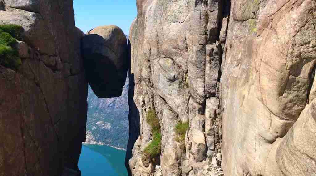
Kjeragbolten, a five-cubic-meter boulder wedged in a mountain crevasse 1,000 meters above Lysefjord, represents one of Norway’s most dramatic and photogenic natural phenomena. This challenging hike across the Kjerag plateau rewards determined adventurers with the unforgettable opportunity to step onto this suspended rock, creating images that capture the raw, unprotected beauty that defines Norwegian outdoor experiences.
Key Takeaways
- The Kjeragbolten hike covers 10-11 kilometers round trip with 760 meters elevation gain, requiring 5-7 hours to complete depending on fitness and conditions
- Three steep sections equipped with chains and cables demand both physical fitness and mental confidence, making this significantly more challenging than Pulpit Rock
- Parking at Øygardstøl trailhead costs 300 NOK, with the site accessible only mid-May through October due to seasonal road closures
- The drive from Stavanger takes 2.5 hours each way via the scenic mountain road through Sirdal, making this a full-day commitment
- Weather conditions change rapidly at 1,000+ meter elevation; fog creates genuine danger of getting lost on the exposed plateau requiring potential rescue
- Despite dramatic appearance, Kjeragbolten itself is stable—no fatalities have occurred from stepping on the boulder, though the hike demands serious preparation and respect
People Also Ask About Kjeragbolten 2026
How difficult is the Kjeragbolten hike?
The Kjeragbolten hike is classified as challenging to difficult, significantly more demanding than the popular Pulpit Rock trail. The 10-11 kilometer route requires good physical fitness, comfort with heights, and confidence using chains and cables on steep rock faces. Three major climbs and descents punctuate the hike, with the steepest sections featuring near-vertical granite requiring pulling yourself up using fixed chains. The psychological challenge of exposed heights equals or exceeds the physical demands—some hikers find the chain-assisted descents particularly intimidating when facing downward over sheer drops. Total elevation gain of 760 meters spread across undulating terrain means constant ups and downs rather than a single sustained climb. Experienced hikers typically complete the route in 5-6 hours, while those less experienced with mountain terrain should budget 6-8 hours including breaks. The difficulty increases substantially in wet conditions when rocks become slippery, or in poor visibility when navigation across the exposed plateau becomes challenging. Anyone attempting Kjeragbolten should have previous hiking experience with elevation gain and be comfortable with scrambling on steep, rocky terrain.
Is Kjeragbolten safe to stand on?
Standing on Kjeragbolten is safe for those who approach it sensibly and follow basic precautions. The boulder itself is extremely stable—it has been wedged in the crevasse for approximately 50,000 years since glacial retreat left it in its current position. The rock measures about 5 cubic meters and weighs an estimated 5 tons, solidly locked between the cliff walls with no recorded incidents of movement. Remarkably, no fatalities have occurred from the boulder itself despite hundreds of thousands of visitors stepping onto it over recent decades. The actual danger comes from the surrounding context: the boulder sits 1,000 meters above Lysefjord with the crevasse dropping away on both sides, and the approach requires crossing exposed rock surfaces that can be slippery when wet. Safe practice involves stepping onto the boulder from the secure side (where the trail approaches), staying low with good balance, and not attempting dangerous poses or movements that could cause slipping. Wind can be strong at this elevation, so avoid the boulder entirely in high wind conditions. Most importantly, never jump on the boulder or attempt stunts—while the rock itself won’t fail, losing balance could be fatal. Sensible visitors who treat Kjeragbolten with appropriate respect find it thrilling but safe.
How long does it take to hike Kjeragbolten?
Most hikers complete the Kjeragbolten round trip in 5-7 hours total including time at the boulder and brief rest breaks, though times vary significantly based on fitness level, weather conditions, and how long you spend at the summit. Fit, experienced mountain hikers can complete the 10-11 kilometers in 5 hours, while those less experienced or wanting a more leisurely pace should budget 6-8 hours. The outbound journey to Kjeragbolten typically takes 2.5-3.5 hours with the three steep chain-assisted climbs requiring slow, careful progress. Time at Kjeragbolten varies from 20 minutes for those wanting quick photos to 60+ minutes for lunch breaks and extended viewing. The return trip takes 2-3 hours with the chain-assisted descents often requiring more time than ascents as downward-facing exposure creates psychological challenges. When planning your day, factor in the 2.5 hour drive each way from Stavanger plus potential delays from weather checks or parking congestion during peak season, making this a 10-12 hour total commitment from leaving Stavanger to returning. Starting early (7-8 AM departure from Stavanger, 10-10:30 AM hike start) ensures sufficient daylight for the complete journey even if the hike takes longer than expected.
When is the best time to hike Kjeragbolten?
The best time to hike Kjeragbolten is late June through September when the access road is reliably open, weather is most stable, and all facilities operate. Within this window, late June and September offer optimal conditions balancing good weather with fewer crowds, while July-August brings warmest temperatures but significantly more hikers creating bottlenecks on the narrow chain sections. The road from Sirdal to Lysebotn typically opens mid-May and closes in late October or early November depending on snowfall, though early and late season conditions can be challenging with snow patches on the trail and unpredictable weather. June provides the advantage of extended daylight (18+ hours) allowing flexible start times, while September features beautiful autumn colors and crisp, clear days ideal for photography. Avoid attempting Kjeragbolten in fog or rain—the exposed granite becomes dangerously slippery when wet, and poor visibility on the plateau has led to numerous rescue situations when hikers become disoriented and lost. Weather at the 1,000-meter plateau differs dramatically from conditions in Stavanger or even at the parking area, so check mountain forecasts specifically and assess conditions at the trailhead before committing to the hike. For those seeking solitude, weekday hikes in June or September see 70-80% fewer people than summer weekend crowds.
Extended multi-day tours – 5+ days
Featured Stavanger Multi-Day Tour Packages
3 days
Stavanger 3-Day Discovery Tour
- ✓ Comprehensive Stavanger experience
- ✓ Expert local guides included
- ✓ All accommodation included
- ✓ Transportation provided
5 days
Stavanger 5-Day Highlights Experience
- ✓ Comprehensive Stavanger experience
- ✓ Expert local guides included
- ✓ All accommodation included
- ✓ Transportation provided
7 days
Stavanger 7-Day Cultural Journey
- ✓ Comprehensive Stavanger experience
- ✓ Expert local guides included
- ✓ All accommodation included
- ✓ Transportation provided
10 days
Stavanger 10-Day Complete Adventure
- ✓ Comprehensive Stavanger experience
- ✓ Expert local guides included
- ✓ All accommodation included
- ✓ Transportation provided
Multi-day tour packages powered by TourRadar. Prices and availability subject to change.
Understanding Kjeragbolten 2026
Kjeragbolten occupies a unique position in Norway’s hierarchy of famous hikes—more challenging than Pulpit Rock, less technically demanding than Trolltunga, and offering a singular photographic opportunity that has made it a social media phenomenon. The boulder’s precarious appearance suspended between cliff walls creates images that seem almost impossible, driving much of its current popularity among international visitors.
The geological formation dates to the end of the last ice age approximately 50,000 years ago when retreating glaciers created the crevasse and left the boulder wedged in its current position. The rock measures roughly 5 cubic meters with an estimated weight of 5 tons, firmly locked between the granite walls at 1,000 meters elevation. Despite appearing precariously balanced, the boulder has remained stable for millennia with no recorded movement or stability concerns.
Kjeragbolten’s fame has grown exponentially over the past decade, transforming from a relatively obscure hiking destination known mainly to Norwegian outdoor enthusiasts into an international bucket-list attraction. Instagram and social media sharing created this transformation, with dramatic photos of people standing on the suspended boulder generating viral attention. This popularity brings both benefits and challenges—improved trail maintenance and better facilities at the parking area, but also crowding during peak summer weekends and environmental pressure on the fragile mountain plateau.
The Kjerag plateau itself extends beyond just the boulder, offering spectacular views over Lysefjord from 1,084 meters elevation. The same plateau attracts BASE jumpers who leap from the cliff edges (this is not part of the hiking experience and requires specialized training and permits). The combination of hikers, climbers, and BASE jumpers creates a unique mountain environment during summer months.
Trail reconstruction in recent years by Nepalese Sherpas—the same workers who improved Pulpit Rock and Reinebringen—has enhanced the route with stone stairs, improved drainage, and strategic placement of chains on the steepest sections. This work has made the hike safer and more sustainable while preserving its challenging character. The three major chain sections remain intimidating and demanding, ensuring Kjeragbolten maintains its reputation as a serious mountain hike rather than a casual walk.
Getting to Kjeragbolten 2026
Driving from Stavanger
Most visitors base themselves in Stavanger and drive to the Øygardstøl parking area, a journey of approximately 2.5 hours covering 140 kilometers. The route follows the E39 south from Stavanger, then turns inland on route 468 through Sirdal before joining the dramatic mountain road descending to Lysebotn and climbing back up to the trailhead.
The Sirdal mountain road (route 468 and county road FV500) closes annually from late October/early November through mid-May due to heavy snow at high elevations. Exact opening and closing dates vary by winter severity and spring snowmelt. Check road status on vegvesen.no or the official Kjerag website before planning your trip, particularly in May and October when conditions are most variable.
The drive itself ranks among Norway’s most spectacular, climbing through mountain plateaus with expansive views before descending into Lysebotn via 27 hairpin turns—a thrilling road dropping 900 meters in just 6 kilometers. This descent and subsequent climb to Øygardstøl can be challenging for nervous drivers, though the road is well-maintained and safely navigable with care. The final 15 kilometers from Lysebotn to the parking area climbs steeply through dramatic landscape.
Fuel and supplies are limited in this remote area. Fill your tank in Stavanger or Sirdal, as Lysebotn has no gas station. Restaurants exist in Lysebotn but options are very limited. Pack food and water from Stavanger for maximum flexibility and cost savings.
Alternative: Ferry to Lysebotn
Tourist ferries operate through Lysefjord from Stavanger to Lysebotn during summer months, providing a scenic alternative to driving the entire route. This option requires more planning and creates a longer overall journey, but offers spectacular fjord views and a unique approach to the hike. From Lysebotn ferry terminal, you need a taxi or shuttle bus to reach Øygardstøl parking (15-20 minutes, arrange in advance). This option works best when combined with overnight accommodation in Lysebotn.
Bus Tours from Stavanger
Go Fjords operates organized bus transportation from Stavanger to Kjeragbolten during summer 2026. Service runs daily in July and August, then weekends only in September. Departure from Stavanger Byterminalen at 7:45 AM arrives at Øygardstøl around 10:15 AM, with return bus departing at 4:30 PM. This schedule provides approximately 6 hours at the trailhead—sufficient for most hikers though timing can feel tight if the hike takes longer than expected or weather causes delays.
Bus tour cost is approximately 600-750 NOK return per person (check official website for current 2026 rates). This represents good value compared to driving when factoring in fuel (€40-50), parking (300 NOK), and car rental if needed. The bus eliminates driving stress on the challenging mountain roads and ensures departure discipline (knowing the return bus time prevents overextension). However, the fixed schedule reduces flexibility if you want to start hiking earlier or spend more time at the summit.
Parking at Øygardstøl 2026
The official parking area at Øygardstøl accommodates approximately 400 vehicles with parking attendants directing traffic during busy periods. Cost is 300 NOK for over 2 hours (hiking time makes shorter parking impractical). Payment is typically collected by attendants when you arrive, though card payment machines are also available. The parking fee includes access to toilet facilities and supports trail maintenance.
Free parking exists further from the trailhead along route FV500, adding 30-45 minutes walking each way to your hike. Some hikers use this option to save the 300 NOK fee, though the extra kilometer each direction and lack of facilities at these informal parking areas make the official lot worthwhile for most visitors. Free parking areas can be unclear regarding restrictions, so verify you’re in a legal spot to avoid tickets or towing.
During peak season (July-August weekends), the parking area can fill by mid-morning. Arriving before 9 AM ensures space and allows an earlier hike start avoiding the worst crowds on the trail. Parking attendants provide current weather and trail conditions when you arrive—ask about these before starting your hike.
The Kjeragbolten Trail: Complete Description 2026
Trail Statistics
- Total Distance: 10-11 kilometers round trip
- Elevation Gain: 760 meters total (undulating terrain with multiple ups and downs)
- Highest Point: 1,084 meters at Kjerag plateau
- Average Time: 5-7 hours round trip including time at Kjeragbolten
- Difficulty: Challenging to Difficult
- Trail Type: Mountain path with Sherpa-built stone stairs, steep granite climbs with chains, exposed plateau crossing
- Season: Mid-May through October (road closed November-April)
Section 1: First Ascent – The Chain Section (0-1.5 km)
The trail begins innocuously from the parking area before quickly revealing its true character. Within 500 meters, you encounter the first of three major chain-assisted climbs—a steep granite face requiring pulling yourself up using fixed steel cables. This initial ascent gains approximately 250 meters over a short distance, with sections approaching near-vertical angles.
The chains are well-maintained and securely anchored, designed to handle the weight and stress of thousands of climbers. However, the exposure is real: looking down while climbing reveals steep drops and boulder fields far below. Those uncomfortable with heights often find this first section the most psychologically challenging, as it immediately tests your comfort level with exposure and steep terrain. If you struggle significantly with this first climb, consider turning back rather than committing to the full route where similar challenges await.
Proper technique involves using the chains for balance and security while legs do the actual work of climbing. Face into the slope, maintain three points of contact (two hands and one foot or two feet and one hand), and move deliberately rather than rushing. Take breaks at wider sections where you can step aside without blocking other hikers. The ascent typically takes 30-45 minutes of sustained climbing effort.
Once atop the first climb, the trail crosses a rocky plateau section with stunning views back over Lysebotn and down to Lysefjord. This provides welcome respite and your first real sense of the dramatic landscape you’re entering.
Section 2: Lysefjord Valley Descent and Second Ascent (1.5-4 km)
The trail descends steeply into the Lysefjord valley—a dramatic bowl-shaped depression crossed on route to the main plateau. This descent loses much of the elevation gained in the first climb, which can be mentally challenging knowing you’ll need to regain it later. However, the valley features some of the hike’s most beautiful scenery with small streams, wildflower meadows, and intimate mountain landscapes.
Crossing the valley floor, the trail passes water sources where you can refill bottles (the only reliable water on the route). The second major chain section begins as you climb out of the valley, again featuring steep granite requiring cable assistance. This climb is slightly longer than the first, gaining approximately 300 meters to reach the second plateau area.
At the 3-kilometer mark (roughly 2 hours from start), you’ve completed two of the three major climbs and stand on a high plateau with increasingly spectacular views. Many hikers take extended breaks here, knowing the remaining distance is less severe though still challenging.
Section 3: Second Valley and Third Ascent (4-5 km)
A second valley crossing involves descending and then climbing the third and final chain section. By this point, your legs feel the accumulated elevation changes, and the repetitive pattern of steep up, steep down, steep up again creates fatigue even for fit hikers. The third chain section is shorter than the previous two but feels harder due to accumulated tiredness.
Mental fortitude becomes as important as physical fitness during this section. The knowledge that you’re nearing Kjeragbolten provides motivation to push through fatigue. The trail is well-marked with cairns and red “T” markers, though navigation requires attention particularly if fog descends on the plateau.
Section 4: Plateau Walk to Kjeragbolten (5-5.5 km)
After completing the third climb, the terrain flattens onto the exposed Kjerag plateau. The final kilometer to Kjeragbolten crosses relatively level ground, though the exposed nature of the landscape and strong winds common at this elevation create their own challenges. Fog can descend rapidly on the plateau, obscuring visibility and making navigation difficult—this is when hikers most frequently become disoriented and lost.
Following cairns and markers, the trail leads to the main Kjerag summit area. A signpost cairn built by Stavanger Turistforening directs hikers to Kjeragbolten, located approximately 300 meters south of the main summit. The detour to the boulder is essential—you haven’t come this far to skip the main attraction.
Kjeragbolten – The Famous Boulder
Approaching Kjeragbolten, the crevasse appears suddenly—a dramatic crack in the mountain with the boulder wedged between walls. The setup is even more spectacular than photos suggest: looking down into the crevasse reveals the 1,000-meter drop to Lysefjord far below, while the boulder sits at what appears to be an impossible position suspended in space.
Accessing the boulder requires crossing exposed rock to reach the approach point. During crowded conditions (summer weekends), queues form as people wait their turn to step onto Kjeragbolten and pose for photos. The wait can extend 20-30 minutes during peak times but moves steadily as most people take just a few minutes for photos before yielding to the next person.
Stepping onto Kjeragbolten involves crossing from the secure ledge to the boulder itself—a step that feels much more significant than it is. The boulder is completely stable with no movement or wobble. Stay low, maintain good balance, and move deliberately. Wind is the main hazard, so avoid the boulder entirely if strong gusts are blowing. Most people crawl or crouch rather than standing fully upright, which is both safer and creates better photos.
The views from Kjeragbolten and the surrounding plateau are extraordinary—Lysefjord stretches below, mountain peaks extend in all directions, and the sense of being suspended in space above the fjord creates an unforgettable experience. Budget at least 30-45 minutes at the summit area for photos, lunch, and simply absorbing the landscape you worked so hard to reach.
The Return Journey
The return follows the same route in reverse, with the psychological challenge shifting from upward climbs to downward descents on the chain sections. Many hikers find descending the steep granite faces more intimidating than climbing them, as facing downward over exposure feels more precarious even though the chains provide identical security.
Descending technique: Face into the slope, use chains for stability, take small steps, and maintain three points of contact. Move slowly and deliberately—rushing increases risk of slipping. The descent sections often take as long or longer than the ascents due to the psychological challenge and need for careful foot placement.
The complete return typically takes 2-3 hours. By the time you reach the parking area, you’ve covered 10-11 kilometers with 760 meters elevation gain plus equivalent loss, and your legs will feel every meter of it. The restaurant at the parking area provides welcome refreshments and a place to decompress before the 2.5-hour drive back to Stavanger.
What to Bring for Kjeragbolten 2026
Essential Gear
Footwear: High-quality hiking boots with excellent ankle support and aggressive tread are mandatory. The steep granite sections and potential for wet conditions make boots with good grip essential. Trail runners or lightweight shoes are inadequate and dangerous for this terrain.
Gloves: Unlike Pulpit Rock, gloves are highly recommended for Kjeragbolten to protect hands when using chains and scrambling on rocks. Light gloves with grip pads work well, providing protection without sacrificing dexterity.
Layers and Weather Protection: Temperature at 1,000 meters can be 10-15°C colder than at sea level, with strong wind creating additional wind chill. Bring base layer, insulating mid-layer (fleece or light down), and waterproof shell jacket and pants. Even in summer, summit temperatures can drop to 5-10°C with wind.
Food and Water: Bring substantial lunch and high-energy snacks for 6-8 hours of hiking. Water sources exist at valley crossings (around 3 km point) for refilling, but start with at least 1.5 liters. The physical demands of this hike require more calories than easier trails.
First Aid and Safety: Basic first aid kit, headlamp (in case of unexpected delays), emergency whistle, and phone with emergency numbers. Navigation app with downloaded offline maps provides backup if fog descends.
Recommended Items
Trekking Poles: Highly valuable for the steep descents and chain sections, providing stability and reducing impact on knees. Collapsible poles can be stowed during chain climbs when you need both hands free.
Camera/Phone: The photographic opportunities at Kjeragbolten justify bringing quality camera equipment, though protect it in a secure bag during scrambling sections. Extra batteries or power bank as cold temperatures drain batteries quickly.
Backpack: 25-30 liter capacity with good support and hip belt to distribute weight during steep climbs. The pack will feel heavy during chain sections, so proper fitting is important.
What to Leave Behind
Minimize weight ruthlessly—every unnecessary item makes the steep climbs harder. Large cameras and heavy gear should be considered carefully against the challenge of carrying them up three major ascents. Leave cotton clothing in favor of technical fabrics that wick moisture and dry quickly.
Safety Considerations for Kjeragbolten 2026
Weather Hazards
Weather represents the primary safety concern at Kjeragbolten. The exposed 1,000-meter plateau experiences severe conditions that can develop rapidly. Fog is particularly dangerous as the featureless plateau offers few navigation landmarks—hikers become disoriented and lost regularly when visibility drops below 20-30 meters. Norwegian rescue services respond to multiple incidents each summer of hikers requiring evacuation when trapped by fog.
Check weather forecasts specifically for mountain conditions at 1,000 meters, not sea-level forecasts for Stavanger which can differ dramatically. The parking attendants receive updated conditions and can advise whether hiking is safe. If fog or heavy rain is forecast, postpone the hike without hesitation. The boulder will still be there tomorrow.
Rain makes the granite chain sections extremely slippery and dangerous. What is challenging but manageable in dry conditions becomes genuinely hazardous when wet. If rain begins during your hike, seriously consider turning back rather than pushing on to Kjeragbolten.
Physical Demands and Fitness Requirements
Kjeragbolten requires substantially better fitness than Pulpit Rock. The combination of distance, elevation gain, technical chain sections, and extended duration means casual hikers often struggle significantly. Honestly assess your fitness before committing to this hike. If you cannot comfortably hike 10 kilometers with 700+ meters elevation gain, choose an easier objective.
Previous hiking experience with scrambling on steep terrain is highly valuable, though not absolutely mandatory. First-time mountain hikers should seriously consider hiring a guide who can provide instruction on proper technique and assess whether you have the skills to safely complete the route.
Height Exposure and Psychological Challenges
The chain sections involve genuine exposure—looking down reveals steep drops and long falls. People with fear of heights often struggle psychologically even if physically capable. The boulder itself at the end creates additional psychological pressure with the 1,000-meter drop visible below. There is no shame in turning back if the exposure feels overwhelming—forcing yourself to continue when genuinely frightened increases accident risk.
Navigation on the Plateau
While the trail is well-marked with cairns and red “T” markers, the exposed plateau section requires attention to navigation. In clear conditions following the markers is straightforward, but if fog descends, maintaining route-finding becomes challenging. GPS navigation apps with downloaded offline maps (like Maps.me or AllTrails) provide valuable backup, as does a traditional map and compass if you have the skills to use them.
Emergency Procedures
Emergency number in Norway is 112 for police, ambulance, and rescue coordination. Mobile coverage exists at the parking area and on the plateau in most conditions, though not guaranteed in the valleys. Rescue operations can take several hours to mobilize, particularly in difficult weather. Carrying emergency shelter (bivvy bag), extra layers, and high-energy food provides protection if forced to wait for rescue.
Accommodation Options Near Kjeragbolten 2026
Lysebotn
This tiny village at the head of Lysefjord offers limited accommodation options closest to the trailhead. Lysebotn Turisthytte provides basic mountain lodge accommodation with rooms and shared facilities. Several small B&Bs and guesthouses operate during summer. Staying in Lysebotn allows very early hike starts and eliminates the 2.5-hour drive from Stavanger, though dining options are extremely limited and the village has minimal services beyond accommodation and a couple of restaurants.
Camping is possible at designated sites near Lysebotn for those with tents or campervans, providing the most budget-friendly option. Wild camping is permitted following Norwegian right of roam regulations (at least 150 meters from buildings, leave no trace).
Stavanger
Most visitors base in Stavanger despite the 2.5-hour drive each way. The city offers comprehensive accommodation from hostels (€65) to luxury hotels (€400+), plus numerous restaurants and services for provisioning. This approach makes sense when combining Kjeragbolten with Pulpit Rock and Stavanger city exploration over several days. See separate Stavanger accommodation guide for detailed options.
The trade-off is very early departures (6-7 AM) to allow sufficient time for the drive plus 6-8 hours hiking and return before dark. This creates a 12-14 hour day that feels exhausting even before starting the hike.
Sirdal Area
Small accommodations exist in Sirdal region approximately halfway between Stavanger and Kjeragbolten. This splits the drive into more manageable segments, though options are limited and the area offers little beyond accommodation.
Best Time to Visit Kjeragbolten 2026
By Season
Mid-May to Early June: Road opening period with highly variable conditions. Snow patches likely remain on parts of the trail requiring careful navigation. Weather is unpredictable with cold temperatures (5-10°C at summit) and frequent precipitation. Very few crowds and lower accommodation prices in Stavanger. Only recommended for experienced hikers comfortable with winter-like conditions.
Late June: Excellent shoulder season with improving weather, minimal crowds, and extreme daylight (18+ hours) allowing flexible start times. Temperatures warming to 10-15°C at summit level. This represents one of the best overall periods balancing good conditions with manageable crowds.
July-August: Peak season with warmest weather (15-20°C at summit), most stable conditions, and longest opening hours for bus service from Stavanger. However, significant crowds create bottlenecks on chain sections and long waits (20-30 minutes) for Kjeragbolten photos. Weekends see 500+ hikers on the trail creating traffic jams at technical sections. Best weather but worst crowding.
September: Prime shoulder season with moderate crowds, beautiful autumn colors, and reliable weather early in the month. Temperatures cooling to 10-15°C with shorter days (14 hours daylight). Many experienced hikers consider September the optimal month. Bus service operates weekends only.
October to Mid-May: Road closed, area inaccessible except via specialized winter expeditions with professional guides. Not recommended for normal tourists.
By Day of Week
Weekdays in July-August see 30-50% fewer hikers than weekends. If your schedule allows, hiking Monday-Thursday provides substantially better experience with minimal wait times at Kjeragbolten and less congestion on chain sections.
By Time of Day
Starting early (hike departure by 9-10 AM) allows completing the route before afternoon weather typically deteriorates and before the largest crowds accumulate on the trail. Morning light on Lysefjord is also superior for photography.
Costs for Kjeragbolten 2026
Transportation from Stavanger
- Rental car (one day): €60-90
- Fuel for round trip: €40-50
- Parking at Øygardstøl: 300 NOK (€27)
- Total driving cost: €127-167 (€32-42 per person for 4 people)
Or:
- Bus tour from Stavanger: 600-750 NOK (€55-68) per person
Accommodation
- Lysebotn basic accommodation: €80-120 per night
- Stavanger accommodation: €65-450 per night (wide range)
- Camping: Free (wild camping) to €20-30 (organized sites)
Food and Supplies
- Lunch and snacks from grocery: €10-15
- Restaurant at parking area: €15-25
- Water: Bring from Stavanger (refills available on trail)
Sample Budget Breakdown
Budget Day Trip from Stavanger (per person):
Bus tour €65, packed lunch €12. Total: €77 per person.
Mid-Range Day Trip with Rental Car (4 people):
Rental car €75, fuel €45, parking 300 NOK (€27), packed lunch €12 per person. Total: €195 for 4 people = €49 per person.
Overnight in Lysebotn (per person):
Lysebotn accommodation €100 (double occupancy = €50 each), two meals €40, parking 300 NOK (€27 split). Total: €117 per person for overnight experience.
Frequently Asked Questions
Is Kjeragbolten harder than Pulpit Rock?
Kjeragbolten is significantly harder than Pulpit Rock across every dimension: distance (10-11km vs 8km), elevation gain (760m vs 460m), technical difficulty (three chain-assisted climbs vs none), duration (5-7 hours vs 4-5 hours), and psychological demands (severe exposure vs moderate). The chain sections alone make Kjeragbolten a different category of hike, requiring pulling yourself up steep granite faces using cables. Where Pulpit Rock is accessible to reasonably fit casual hikers, Kjeragbolten demands serious mountain hiking fitness and comfort with exposure and scrambling. Think of Pulpit Rock as a challenging day hike suitable for motivated beginners, while Kjeragbolten requires intermediate hiking skills and solid physical conditioning. However, Kjeragbolten is less demanding than Trolltunga in terms of distance and duration, positioning it in the middle difficulty tier of Norway’s famous hikes. If you struggled significantly with Pulpit Rock, postpone Kjeragbolten until you’ve built more hiking experience and fitness.
Can you hike Kjeragbolten with children?
Hiking Kjeragbolten with children is possible but requires careful assessment of each child’s capabilities, maturity, and hiking experience. The absolute minimum age for most children is 10-12 years old, and even then only if they regularly hike challenging terrain and are comfortable with heights. The chain sections require both physical strength to pull yourself up and mental maturity to follow safety instructions precisely—a child who doesn’t take directions seriously creates serious danger. Teenagers with hiking experience generally handle Kjeragbolten well, though parents must supervise closely at exposure points. The main concerns are: (1) chain sections require pulling your own body weight repeatedly which younger children may lack the strength for, (2) the psychological exposure of looking down 1,000-meter drops can overwhelm even children who claim to be comfortable with heights, (3) the 6-8 hour duration exceeds most children’s endurance limits, and (4) the boulder itself creates temptation for showing off that could be fatal. Some families successfully complete Kjeragbolten with responsible teenagers, but bringing children under 10 is inadvisable regardless of fitness level.
Has anyone ever fallen from Kjeragbolten?
Remarkably, no fatalities have occurred directly from the Kjeragbolten boulder itself despite hundreds of thousands of people stepping onto it over recent decades. The boulder is extremely stable and the actual act of standing on it is safe when approached sensibly. However, several deaths have occurred in the broader Kjerag area from people falling while rock climbing, BASE jumping accidents, or falling from cliff edges away from the marked trail and boulder. The distinction is important: the boulder itself is not dangerous, but the mountain environment around it presents serious hazards requiring appropriate caution. Injuries do occur regularly on the hike itself—sprained ankles from slipping on the chain sections, falls on wet rocks causing fractures, and exhaustion-related accidents when hikers push beyond their limits. The Norwegian rescue services respond to multiple incidents each season requiring helicopter evacuations. The safety record demonstrates that treating Kjeragbolten with respect and following basic mountain safety protocols makes it accessible, but carelessness or underestimating the challenges can lead to serious consequences.
What happens if the weather turns bad during the hike?
If weather deteriorates during your Kjeragbolten hike, your response depends on severity and your current position on the trail. Light rain or clouds without fog generally means continue with caution, as light precipitation alone doesn’t create immediate danger though it does make rocks more slippery. However, heavy rain, thunderstorms, or descending fog require immediate consideration of turning back. The critical decision point is whether you can safely navigate back to the parking area given current and forecast conditions. If you’re already on the plateau when fog descends, follow cairns and markers carefully back toward the parking area—do not attempt to continue to Kjeragbolten as getting lost on the featureless plateau in fog is the most common reason for rescue callouts. If caught in fog and genuinely disoriented, stay put and call 112 emergency services rather than wandering aimlessly which increases chances of walking off a cliff edge. The plateau section is where most people get lost in poor visibility. If weather looks questionable when you arrive at the parking area, ask the attendants for current conditions and forecasts—they have updated information and will honestly advise if hiking is inadvisable. Remember that turning back disappointed is infinitely better than requiring rescue or worse.
How crowded is Kjeragbolten compared to Pulpit Rock?
Kjeragbolten sees significantly fewer hikers than Pulpit Rock—approximately 30,000-40,000 annually versus 300,000+ at Preikestolen. However, this doesn’t mean empty trails. During peak summer weekends (July-August), the Kjeragbolten trail hosts 300-500 hikers creating bottlenecks at the narrow chain sections where only 1-2 people can safely climb at a time. Wait times of 5-10 minutes at each chain section are common when traffic is heavy. At Kjeragbolten boulder itself, summer weekend queues of 15-25 people waiting for photos create 20-30 minute waits for your turn on the rock. Weekday hiking during the same period reduces crowds by 50-70%, with minimal waits at chain sections and 5-10 minute queues at the boulder. Shoulder season (June, September) sees the trail return to genuinely quiet conditions with possibility of having Kjeragbolten to yourself or sharing with just a handful of others. The difference from Pulpit Rock is qualitative—while both can be crowded during peak times, Kjeragbolten’s crowds feel less overwhelming and the technical nature of the trail naturally spreads people out. Starting early (by 9-10 AM) even in peak season allows you to reach Kjeragbolten before the bulk of the crowd arrives.
Do I need a guide for Kjeragbolten?
A guide is not strictly necessary for Kjeragbolten during the main hiking season if you have reasonable mountain hiking experience and comfort with scrambling on steep terrain. The trail is well-marked with cairns, red “T” markers, and chains on the technical sections, making independent navigation straightforward in good visibility. However, hiring a guide provides significant benefits particularly for first-time mountain hikers or those uncertain about their abilities. Professional guides teach proper chain-climbing technique, provide expert assessment of weather conditions and whether to continue or turn back, know the most efficient route navigation across the plateau, and offer psychological support on exposed sections where many hikers feel intimidated. Guides are especially valuable in shoulder season (May, late September-October) when snow patches may remain and weather is less predictable. The cost of guided tours (€120-180 per person) is substantial but includes expert instruction, safety management, and often transportation from Stavanger eliminating logistics stress. Consider a guide if: this is your first serious mountain hike, you have fear of heights but want to attempt the route, you’re hiking solo and want company/security, or weather forecast is marginal and you want expert assessment of conditions. Independent hiking works well for experienced mountain trekkers comfortable with exposure and self-assessment of their abilities.
Can you see Kjeragbolten without doing the hike?
You cannot see Kjeragbolten itself without hiking to it, as the boulder sits at 1,000 meters elevation on the mountain plateau completely out of sight from any road or easily accessible viewpoint. However, you can experience the Kjerag area without the full hike through several alternatives. Lysefjord cruise boats departing from Stavanger or Lysebotn pass below the Kjerag cliffs, providing views of the mountain massif and perspective on the scale of the cliffs, though you won’t see the boulder itself from the fjord. The road from Lysebotn climbing toward Øygardstøl parking offers spectacular views of Lysefjord and the surrounding mountains, with several pullouts for photos—this drive alone is worthwhile even if you don’t hike. Shorter, less demanding hikes in the Lysebotn area provide mountain scenery without Kjeragbolten’s technical challenges, though none approach its dramatic character. For those who want to see Kjeragbolten photos and experience Norwegian mountain landscapes without the demanding hike, the Lysefjord cruise combined with the scenic drive offers a taste of the region’s beauty, but the boulder itself remains exclusively accessible to those willing to complete the challenging trail.
What should I do if I’m afraid of heights on the chain sections?
If fear of heights overwhelms you on Kjeragbolten’s chain sections, several strategies can help though ultimately you may need to accept that this hike exceeds your comfort level. First, remember that fear itself doesn’t equal danger—the chains are secure, thousands of people safely use them, and taking your time is perfectly acceptable. Technique matters: face into the slope rather than looking down, maintain three points of contact, take small steps, and focus on the rock immediately in front of you rather than the drop below. Slow, deliberate movement with controlled breathing (fear causes people to hold their breath worsening panic) helps manage anxiety. During descents which many find more intimidating, use the same principles but add extra caution on foot placement. Trekking poles can help though require managing them while using chains. If panic truly sets in, stop at a secure section, communicate with other hikers who can offer encouragement and space, and honestly assess whether you can continue safely or should turn back. There is zero shame in turning back if the exposure genuinely terrifies you—forcing yourself forward when truly frightened increases accident risk. Consider hiring a guide who can provide personal instruction and psychological support, or gain experience on less exposed hikes before attempting Kjeragbolten. Remember that your mental state directly affects physical safety, so if fear makes you unable to focus on proper technique, the route is not appropriate for you at this time.
Is Kjeragbolten worth the effort compared to other Norwegian hikes?
Kjeragbolten absolutely deserves its reputation as one of Norway’s must-do hikes for those who have the fitness and comfort with exposure to safely complete it. The combination of challenging terrain, spectacular mountain plateau scenery, dramatic views over Lysefjord, and the unique experience of stepping onto the famous boulder creates an unforgettable adventure that justifies the effort for capable hikers. However, “worth it” depends entirely on your personal capabilities and interests. If you enjoy technical mountain hiking, are comfortable with exposure, and want something more challenging than Pulpit Rock, Kjeragbolten delivers exceptional rewards. The boulder itself may seem like a gimmick from photos but standing on it with the 1,000-meter drop visible below creates a genuine thrill that photos cannot capture. The hike itself offers varied, beautiful terrain with the three chain sections adding adventure that purely walking trails lack. Compared to Pulpit Rock, Kjeragbolten sees fewer crowds and attracts more serious hikers creating a different atmosphere. However, if you struggle with steep hiking, fear heights significantly, or prefer less technical trails, the effort-to-reward ratio tilts negative—in those cases Pulpit Rock provides similar fjord views with lower stress and greater accessibility. Overall, for hikers ready for the challenge, Kjeragbolten ranks among Norway’s top experiences; for those uncertain about their abilities, Pulpit Rock offers better value.
What is the Kjerag plateau like beyond the boulder?
The Kjerag plateau extends far beyond Kjeragbolten, offering a dramatic high-mountain environment at 1,000+ meters elevation that appeals to experienced hikers interested in more than just the famous boulder. The plateau features exposed granite surfaces, small tarns and lakes, alpine meadows with wildflowers in summer, and spectacular viewpoints over Lysefjord from multiple angles. The main summit of Kjerag sits 1,084 meters high with a cairn marking the highpoint. The Nesatindane viewpoint provides an alternative perspective different from Kjeragbolten, looking directly down the vertical cliffs to Lysefjord. BASE jumpers use designated exit points on the plateau for their jumps—hikers may encounter them preparing equipment or observe jumps if timing coincides. The plateau can experience severe weather with strong winds, rapid fog development, and dramatic temperature changes even in summer. Beyond standard day hiking, the plateau connects to multi-day traverse routes for serious mountain trekkers, though these require navigation skills, camping equipment, and extensive experience. Most Kjeragbolten hikers focus on reaching the boulder and return directly without exploring the wider plateau, but those with extra time and energy find the summit area and alternative viewpoints rewarding. The exposed, somewhat barren character of the high plateau creates a genuine wilderness feeling far removed from the popular trails lower down.