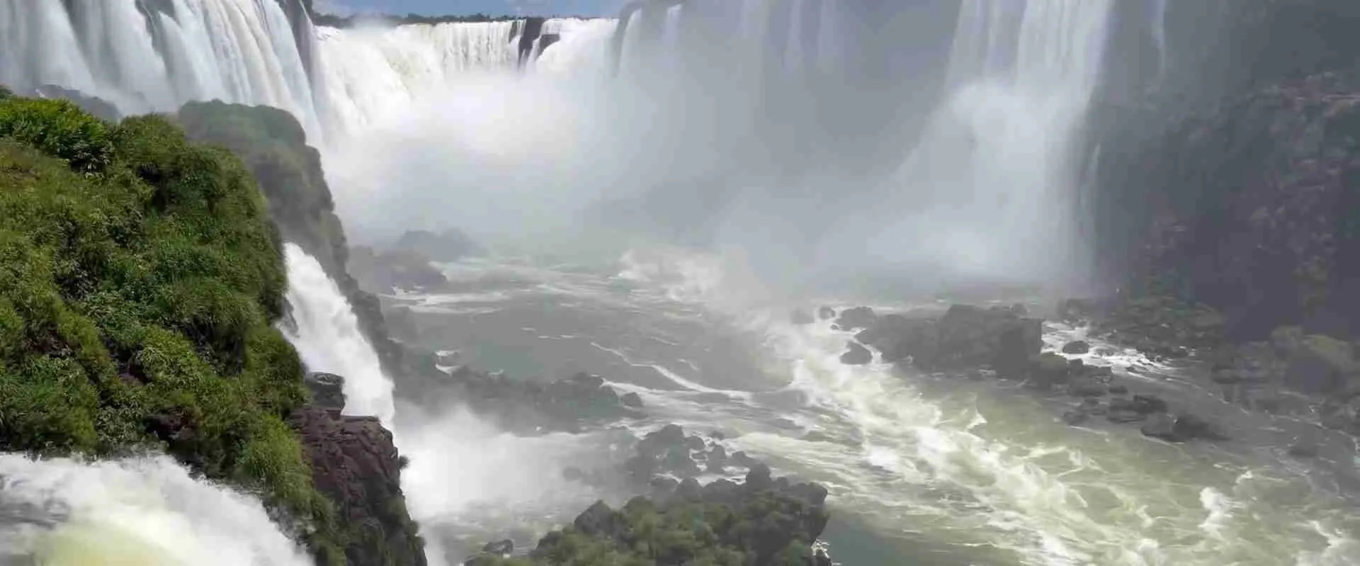
Iguazu Falls Natural Architecture Guide: Geological Structure & Design
This comprehensive guide explores Iguazu Falls as a work of natural architecture, examining the geological structures that enable its existence, the design principles that organize its components, the viewing perspectives that reveal its spatial complexity, and the dynamic processes that ensure continuous evolution. By understanding how natural forces have engineered this magnificent structure, visitors gain deeper appreciation for the falls’ beauty while recognizing the ongoing geological processes that will continue reshaping this masterpiece for millennia to come.
Key Takeaways
- The falls’ distinctive horseshoe architecture results from differential erosion between hard basalt cap rock and softer underlying sedimentary layers
- 275 individual cascades arrange themselves across a 2.7-kilometer-wide escarpment, creating a natural amphitheater design unmatched by any single waterfall
- The Devil’s Throat forms the architectural centerpiece: a U-shaped chasm 80 meters wide and 150 meters long where 14 separate falls converge
- Three-tiered vertical structure includes upper basalt ledge (20-82 meters high), middle erosion zone with columnar formations, and lower impact pools
- Natural walkway systems formed by resistant basalt islands enable intimate viewing access impossible at most major waterfalls
- Dynamic architecture continuously evolves through erosion at approximately 3 millimeters annually, migrating upstream over geological time
Introduction: Nature’s Engineering Masterpiece
Iguazu Falls represents one of nature’s most sophisticated architectural achievements, where geological forces have crafted a structure of breathtaking beauty and engineering complexity. Unlike the simple vertical plunge of many famous waterfalls, Iguazu displays intricate spatial organization with multiple levels, diverse viewing perspectives, and dramatic variation in scale and character across its nearly 3-kilometer width. The falls function as a massive natural amphitheater where water, rock, vegetation, and space interact to create an immersive sensory experience that overwhelms visitors with its scale and power.
Understanding the falls’ natural architecture requires examining multiple interrelated elements: the geological foundation of basalt and sedimentary rock that provides the structural framework, the erosion processes that continuously reshape the cascades, the spatial organization of individual falls within the broader system, the relationship between rock formations and water flow patterns, and the integration of rainforest vegetation into the overall composition. Each element contributes to the whole, creating a unified yet complex structure that rewards detailed analysis while maintaining overwhelming immediate visual impact.
People Also Ask About Iguazu Falls Natural Architecture
How are Iguazu Falls structured geologically?
Iguazu Falls possesses a three-layer geological structure that determines its basic architectural form. The top layer consists of highly resistant basalt rock approximately 20-30 meters thick, formed by ancient volcanic eruptions around 130 million years ago. This basalt cap rock forms the waterfall lip and resists erosion more effectively than underlying layers. The middle layer comprises softer sedimentary rocks including sandstones, siltstones, and shales deposited before volcanic activity. These sedimentary layers erode much faster than the basalt, creating the characteristic undercut profile where water plunges over a projecting basalt ledge. The bottom layer includes additional sedimentary rocks that form the riverbed downstream of the falls. Water flowing over the falls strikes these lower rocks with tremendous force, excavating deep plunge pools and gorges. This differential erosion between hard basalt and soft sedimentary rock creates the falls’ distinctive profile and enables their ongoing upstream migration as undermined basalt periodically collapses, exposing fresh sedimentary rock to erosion in a continuous cycle.
Why does Iguazu have so many separate falls instead of one big waterfall?
The 275 individual cascades result from irregular erosion patterns creating distinct channels separated by basalt islands and ridges. Water flow concentrates in weak points where the basalt contains cracks, joints, or areas of reduced resistance. These concentrated flows erode faster than surrounding areas, carving deep channels that become individual waterfalls. Over time, differential erosion creates complex topography with protruding basalt islands between channels. Seasonal variations in water level expose different portions of the escarpment, with high water covering many islands and low water revealing additional rock formations. The falls’ width of 2.7 kilometers provides space for this complex pattern to develop across a broad front rather than concentrating into a single plunge. The result resembles an architectural colonnade with repeated vertical elements (individual falls) separated by solid structures (basalt islands), creating rhythm and visual complexity impossible in a single cascade. This multi-fall configuration also distributes erosive power across the escarpment rather than concentrating it in one location, influencing how the falls evolve over geological time.
What makes the Devil’s Throat unique architecturally?
The Devil’s Throat (Garganta del Diablo) functions as the architectural focal point and dramatic climax of the Iguazu Falls system. This horseshoe-shaped chasm measures approximately 80 meters wide, 150 meters long, and plunges 82 meters—the greatest height difference anywhere in the falls system. Fourteen separate waterfalls converge into this single throat, concentrating tremendous water volume and power into a confined space. The horseshoe configuration creates an amphitheater effect that amplifies sound and generates massive spray clouds rising 30-50 meters above the falls. The Devil’s Throat’s unique positioning at the Argentina-Brazil border places viewing platforms from both countries, though the Argentine side’s elevated boardwalk positioning visitors directly above the chasm delivers the most dramatic perspective. The throat’s depth creates a perpetual mist cloud that often obscures the bottom, adding mystery and emphasizing the tremendous depth. Geologically, the Devil’s Throat represents the deepest and most actively eroding section of the falls system, where concentrated flow accelerates undermining of the basalt cap and drives the falls’ upstream migration. This combination of maximum height, concentrated power, dramatic spatial enclosure, and visual inaccessibility creates an architectural experience of overwhelming sublimity.
How do the Argentine and Brazilian sides differ architecturally?
The two sides offer contrasting architectural perspectives on the same natural structure, creating complementary viewing experiences. The Argentine side hosts approximately 80% of the waterfall system, positioning viewers within and alongside the falls through extensive walkway systems that follow the escarpment edge. This intimate positioning creates sequential revelation as visitors walk from fall to fall, experiencing the architecture through proximity and varied angles. The upper circuit walkway system traces the escarpment top, placing viewers level with or slightly above the falls’ crest where water begins its plunge. The lower circuit descends to the base level, positioning viewers below the falls looking up at towering cascades. The Devil’s Throat boardwalk extends directly over the main chasm, creating the ultimate interior architectural experience. The Brazilian side provides exterior perspective from across the gorge, revealing the falls’ full two-mile width in sweeping panoramas impossible from the Argentine side. This distanced viewpoint emphasizes horizontal extension and overall composition rather than individual fall details. The Brazilian viewing path descends gradually alongside the falls, providing continuously changing perspectives from upper elevation through mid-level to bottom viewpoints. These contrasting approaches—intimate interior exploration versus comprehensive exterior overview—reflect fundamentally different architectural relationships with the natural structure.
Extended multi-day tours – 5+ days
Featured Iguazu Falls Multi-Day Tour Packages

3 days
Iguazu Falls 3-Day Discovery Tour
- ✓ Comprehensive Iguazu Falls experience
- ✓ Expert local guides included
- ✓ All accommodation included
- ✓ Transportation provided
5 days
Iguazu Falls 5-Day Highlights Experience
- ✓ Comprehensive Iguazu Falls experience
- ✓ Expert local guides included
- ✓ All accommodation included
- ✓ Transportation provided

7 days
Iguazu Falls 7-Day Cultural Journey
- ✓ Comprehensive Iguazu Falls experience
- ✓ Expert local guides included
- ✓ All accommodation included
- ✓ Transportation provided

10 days
Iguazu Falls 10-Day Complete Adventure
- ✓ Comprehensive Iguazu Falls experience
- ✓ Expert local guides included
- ✓ All accommodation included
- ✓ Transportation provided
Multi-day tour packages powered by TourRadar. Prices and availability subject to change.
Geological Foundation and Structural Elements
Basalt Cap Rock Formation
The Serra Geral basalt formation that creates Iguazu Falls’ structural foundation originated approximately 130 million years ago during one of Earth’s most extensive volcanic episodes. Continental rifting associated with Gondwana supercontinent breakup generated massive fissure eruptions that flooded vast areas with fluid basalt lava. These eruptions occurred in multiple episodes over several million years, building up basalt layers 1,000+ meters thick across portions of southern Brazil, northeastern Argentina, Paraguay, and Uruguay. The individual basalt flows cooled into distinct layers with varying crystal sizes, mineral compositions, and mechanical properties depending on cooling rates and lava chemistry.
At Iguazu specifically, the basalt forms a cap rock layer 20-30 meters thick at the falls’ crest. This rock exhibits medium to fine-grained texture indicating relatively rapid cooling. The basalt contains characteristic columnar jointing—vertical fractures that divide the rock into polygonal columns created by cooling contraction. These columns range from 30 centimeters to over 1 meter in diameter and extend through the full basalt thickness. The columnar structure influences erosion patterns as water preferentially exploits joints between columns, carving channels that eventually develop into separate waterfalls.
The basalt’s mineral composition includes plagioclase feldspar, pyroxene, and olivine crystals set in a fine-grained or glassy groundmass. This composition provides high compressive strength and resistance to weathering, enabling the basalt to form stable waterfall lips that project beyond underlying softer rocks. However, the rock is not indestructible—water pressure, freeze-thaw cycles in joints, and chemical weathering gradually weaken the basalt, eventually causing collapse that drives the falls’ upstream migration.
Sedimentary Underlayers and Differential Erosion
Beneath the resistant basalt cap lie softer sedimentary rocks that erode much more rapidly, creating the characteristic undercut profile essential to waterfall maintenance. These sedimentary layers were deposited 135-145 million years ago in desert and river environments before volcanic eruptions buried them under basalt flows. The sedimentary sequence includes multiple rock types with varying erosion resistance. Sandstones form relatively resistant layers that erode more slowly than surrounding rocks, sometimes creating ledges or terraces in the escarpment face. Siltstones and mudstones erode rapidly, developing recesses and caves behind the waterfall curtain. Occasional thin basalt layers interbedded with sedimentary rocks create additional resistant horizons.
Differential erosion between basalt and sedimentary rock creates the classic waterfall profile where hard rock projects beyond soft rock. Water plunging over the basalt lip strikes the softer sedimentary layers below, excavating them through hydraulic force and abrasion by suspended sediment. This excavation gradually undermines the basalt overhang, creating increasingly unstable cantilevers that eventually collapse. The collapse removes basalt from the waterfall crest, exposing fresh sedimentary rock to continued erosion and causing the falls to migrate upstream. This cycle of undermining and collapse operates continuously at different rates across the falls’ width, creating complex topography of protruding basalt islands, deep channels, and varied fall heights.
The sedimentary layers exhibit visible stratification where different rock types create alternating resistant and weak bands. These bands influence the escarpment’s detailed morphology, creating step-like profiles, caves, and alcoves. In some locations, particularly resistant sandstone layers form pronounced ledges that partially protect underlying softer rocks from erosion, creating overhangs and sheltered areas behind falling water. Understanding this stratification helps explain the falls’ architectural complexity and predicts future evolution patterns.
Structural Zonation and Vertical Architecture
The falls display three-tiered vertical architecture reflecting different geological processes operating at different elevations. The upper zone (approximately 15-20 meters above the falls’ crest) comprises intact basalt forming the escarpment top and vegetated islands. This zone experiences minimal water-related erosion during normal flow, though high floods occasionally overtop the islands and contribute to gradual surface weathering. Soil development and vegetation growth on this upper surface stabilize the basalt against erosion while creating parkland landscape. The walking trail systems traverse this upper zone, taking advantage of the stable basalt platform.
The middle zone encompasses the waterfall face itself, spanning from the basalt lip to the impact point approximately 20-82 meters below (height varies across the falls’ width). This zone experiences the most dramatic erosion as falling water exerts tremendous force on underlying sedimentary rocks. The falling water creates negative pressure behind the waterfall curtain, drawing air and spray toward the rock face and intensifying erosion. Spray wetting promotes chemical and biological weathering of the rock face, further accelerating degradation. The middle zone’s architecture changes most rapidly, with individual waterfalls altering height, width, and character over decadal timescales as erosion proceeds at varying rates.
The lower zone includes the plunge pools and downstream gorge where falling water dissipates its energy. Deep pools carved into the riverbed by hydraulic action can exceed 20 meters depth at major falls. Turbulent water in these pools generates tremendous shearing force that excavates rock and transports eroded sediment downstream. Large boulders from collapsed basalt accumulate in and around plunge pools, creating obstacles that influence water flow patterns and contribute to continued erosion through abrasion. The lower zone architecture reflects the cumulative power of falling water concentrated at impact points, creating the most dynamic and rapidly changing portion of the falls’ structure.
Spatial Organization and Design Patterns
The Horseshoe Configuration
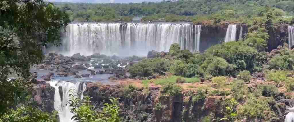
Iguazu Falls arranges itself in a broad horseshoe or crescent shape approximately 2.7 kilometers wide, creating an architectural configuration that maximizes visual impact while enabling diverse viewing perspectives. The horseshoe orientation follows the Iguazu River’s course as it approaches the escarpment, with water spreading across the full width before plunging over the rim. This configuration differs from linear waterfall arrays where falls align in straight or gently curved arrangements. The pronounced curvature creates an amphitheater effect where viewers positioned at certain locations can see falls both directly ahead and to either side, producing an immersive experience of being surrounded by cascading water.
The horseshoe’s outer arc spans the broader array of smaller and medium falls, while the apex curves inward toward the Devil’s Throat. This arrangement concentrates the most dramatic waterfall at the focal point where the horseshoe’s arms converge, creating clear hierarchy in the architectural composition. The gradual scale progression from smaller outer falls to the massive central Devil’s Throat builds anticipation and emphasizes the climactic experience at the center. This organization resembles classical architectural principles where subsidiary elements frame and lead toward a dominant central feature.
The horseshoe configuration also influences flow patterns and erosion rates. Water velocity increases toward the horseshoe’s inner radius where the channel narrows and deepens, concentrating erosive power at the Devil’s Throat. This focused erosion accelerates the Devil’s Throat’s upstream migration compared to outer falls, gradually tightening the horseshoe curve over geological time. The spatial organization thus reflects and influences the dynamic processes that continuously reshape the falls’ architecture.
Island Networks and Viewing Platforms
Basalt islands punctuate the waterfall system, creating natural platforms that divide flows and provide viewing access impossible at most major waterfalls. These islands range from small rocky outcrops a few meters across to substantial landmasses supporting mature rainforest vegetation. The larger islands host boardwalk systems that enable visitors to walk directly alongside and sometimes over individual waterfalls, creating intimate relationships between viewers and falling water. The most developed island networks appear on the Argentine side where the upper and lower circuit trails traverse multiple islands connected by bridges and walkways.
The islands’ irregular distribution creates varied spatial experiences as visitors move through the system. Narrow passages between islands funnel water into powerful jets, while broader spaces allow water to spread and cascade more gently. Some islands position viewers directly beside falling water at the same elevation as the cascade’s crest, while others provide elevated platforms overlooking waterfalls from above. The lower circuit islands place viewers at the base of towering falls, creating dramatic upward perspectives. This spatial variety prevents monotony despite the repetitive waterfall elements, with each viewpoint offering distinct architectural experience.
The islands also demonstrate the ongoing geological processes reshaping the falls. Smaller islands represent resistant basalt remnants that will eventually erode away as undermining proceeds. Some islands show visible erosion on their upstream faces where water flowing around them excavates their foundations. Vegetation growth on islands stabilizes their surfaces and slows degradation, while root penetration into cracks can contribute to rock fracturing. The dynamic between island formation, erosion, and vegetation colonization creates continuously evolving architecture that will look substantially different in future centuries and millennia.
Rhythm and Repetition Across the Escarpment
The 275 individual falls create architectural rhythm through repetition of similar vertical elements at varying scales and spacings. This rhythm resembles colonnades in classical architecture where repeated columns create visual coherence across extended facades. At Iguazu, the repeated waterfall forms organize the nearly 3-kilometer-wide escarpment into comprehensible visual units despite the overwhelming overall scale. The human eye can grasp individual falls as discrete elements, reading the composition as an array of related forms rather than undifferentiated chaos.
The rhythm varies in tempo across the falls’ width, with some sections featuring closely spaced narrow cascades creating rapid visual beats, while other areas show widely spaced broader falls generating slower rhythm. This variation prevents monotony and creates zones of different character. The western section of the Argentine side features relatively regular spacing of medium-sized falls, creating steady rhythm. The area approaching the Devil’s Throat shows more irregular spacing with dramatically varying fall widths, accelerating the rhythm and building visual tension. The Devil’s Throat itself breaks the rhythm completely with its overwhelming singular presence, functioning as architectural climax.
Vertical repetition also operates at smaller scales within individual falls. Stratified sedimentary layers in the escarpment face create horizontal banding that repeats across multiple falls, providing visual unity. Water flow patterns create repeated forms including smooth curtains, turbulent columns, and spray clouds. These nested repetitions at multiple scales—from the 3-kilometer-wide array of separate falls, to horizontal stratification across the escarpment face, to detailed water flow patterns—create fractal-like architectural complexity where similar organizing principles operate at different magnifications.
The Devil’s Throat: Architectural Focal Point
Spatial Enclosure and the Sublime
The Devil’s Throat creates a spatial experience of the sublime—that aesthetic category combining awe, terror, and beauty that philosophers and artists have long associated with overwhelming natural phenomena. The throat’s horseshoe-shaped chasm approximately 80 meters wide and 150 meters long creates partial enclosure that heightens the sense of being within rather than merely viewing a natural structure. The curved walls focus sound, amplifying the thunderous roar of falling water to nearly overwhelming levels. Mist rising from the throat creates visual obscurity that prevents clearly seeing the bottom, adding mystery and emphasizing the tremendous depth.
The Devil’s Throat boardwalk extends directly over the chasm’s edge, positioning viewers above the point where fourteen separate waterfalls converge and plunge into the throat. This positioning creates visceral confrontation with the water’s power as the entire structure vibrates with the impact of tons of water striking rock below. The spray cloud envelops the platform, soaking viewers and creating sensory immersion impossible at distanced viewpoints. The combination of thunderous sound, obscuring mist, structural vibration, and visual awareness of the tremendous drop beneath your feet generates powerful physical and emotional response.
The throat’s spatial enclosure contrasts dramatically with the open exposure of most waterfall viewpoints. Rather than observing from a safe distance, visitors occupy space directly within the falls’ architecture, surrounded by falling water on multiple sides. This enclosure creates intimacy with the natural feature while paradoxically emphasizing its overwhelming scale and power. The throat functions as a natural cathedral or amphitheater where spatial organization manipulates human perception and emotion, demonstrating how natural forms can create architectural experiences rivaling human-built structures.
Vertical Drop and Scale
The Devil’s Throat’s 82-meter vertical drop represents the falls’ maximum height and concentrates tremendous energy into a confined space. This height exceeds Niagara Falls (51 meters) though remains far below single-drop waterfalls like Angel Falls (979 meters). However, the Devil’s Throat’s impact derives less from absolute height than from the combination of substantial vertical drop with enormous water volume concentrated in a relatively narrow chasm. The convergence of fourteen major waterfalls creates flow rates exceeding 1,700 cubic meters per second during average conditions, delivering over 140,000 tons of water per minute into the throat.
The vertical architecture emphasizes the tremendous energy transformation as potential energy (elevated water) converts to kinetic energy (falling water) and finally dissipates as turbulence, sound, heat, and erosion at impact. Physics calculations indicate water striking the bottom after 82-meter free fall reaches velocities near 40 meters per second (144 kilometers per hour), generating impact forces that pulverize rock and excavate deep plunge pools. The visible manifestation of this energy appears in the towering spray cloud, thunderous roar, and continuous mist production that affects local microclimate for hundreds of meters around the throat.
Scale comparison helps comprehension of the throat’s dimensions. The 80-meter width approximates a football field’s width, while the 150-meter length equals 1.5 football fields or a medium-sized city block. The 82-meter height matches a 25-story building. These comparisons to familiar human-scale references help grasp the throat’s size, though direct experience remains necessary to truly comprehend the scale and power of this natural structure.
Erosion and Ongoing Evolution
The Devil’s Throat represents the most geologically active and rapidly eroding section of the entire falls system. The concentrated water flow and tremendous impact forces accelerate undermining of the basalt cap rock and excavation of underlying sedimentary layers. Evidence of active erosion appears in fresh rock faces where recently collapsed basalt exposes clean, unweathered surfaces. Large boulders from past collapses litter the plunge pool area, demonstrating the scale of rockfall events. The throat’s depth reflects this intensive erosion history, with the base carved substantially below the downstream river level.
The upstream migration rate at the Devil’s Throat likely exceeds the falls’ system average due to concentrated erosive power. While precise measurements are difficult given the throat’s inaccessibility, geological evidence suggests migration rates of several millimeters per year—slow by human standards but significant over geological time. Extrapolating current rates suggests the throat will migrate several hundred meters upstream over the next 100,000 years, leaving behind a deep gorge marking its current position.
The ongoing evolution means the Devil’s Throat’s current configuration represents a transient state in continuous transformation. The number and size of waterfalls converging into the throat will change as erosion reshapes upstream channels. The throat’s depth will increase as erosion excavates underlying rocks. The horseshoe shape will tighten or broaden as different sections erode at varying rates. Future generations may encounter a significantly different Devil’s Throat architecture while the fundamental character of the overwhelming spatial experience likely persists through these evolutionary changes.
Viewing Perspectives and Architectural Experience
Argentine Side: Interior Architecture
The Argentine side trail system creates an interior architectural experience by placing visitors within and alongside the falls rather than viewing from external vantage points. This approach delivers sequential intimate encounters with individual waterfalls as visitors walk the upper and lower circuits. The upper circuit follows the escarpment edge for approximately 800 meters, crossing islands and bridges that position viewers directly beside numerous waterfalls at crest level where water begins its plunge. This elevation provides unique perspectives into the falls’ structure, revealing how channels carve through the basalt, how water accelerates as it approaches the lip, and how different flow patterns develop across varying topographies.
The lower circuit descends to the gorge bottom and follows the base of the escarpment for approximately 1,700 meters, placing viewers below towering waterfalls looking upward at water plunging from 20-50 meters above. This upward perspective emphasizes the falls’ vertical scale and power, creating very different psychological experience than top-down views. The lower circuit provides close approach to several major falls where spray drenches the walkway and visitor, creating visceral connection with the water’s force. The combination of upper and lower circuits enables three-dimensional understanding of the falls’ architecture through complementary perspectives.
The Devil’s Throat boardwalk represents the ultimate interior architectural experience, extending 1,100 meters from the train station across multiple islands before reaching a platform suspended directly above the throat’s edge. The extended approach builds anticipation through gradually increasing sound and mist levels. The final platform places visitors at the architectural focal point, surrounded by falling water creating overwhelming sensory immersion. This carefully choreographed sequence from approach through climax demonstrates sophisticated spatial design, though created by natural forces rather than human planning.
Brazilian Side: Exterior Architecture
The Brazilian side offers exterior perspectives that reveal the falls’ overall composition and scale impossible to comprehend from interior Argentine viewpoints. The main Brazilian trail descends approximately 1,200 meters alongside the gorge, providing continuously changing panoramic views across the full horseshoe configuration. Early viewpoints at elevated positions show the falls’ extraordinary width extending across the entire field of vision. The trail’s gradual descent presents the falls from multiple elevations, revealing how the vertical architecture changes with viewing angle.
Mid-level viewpoints provide the most photographically iconic perspectives where the entire falls array appears in one composition. These viewpoints capture the spatial organization of individual cascades within the broader system, the relationship between major falls like the Devil’s Throat and surrounding smaller cascades, and the integration of basalt islands and rainforest vegetation into the overall composition. The distanced perspective enables comprehension of the falls as unified architectural composition rather than collection of discrete elements.
The Brazilian trail concludes at a platform that extends into the gorge directly opposite several major waterfalls, providing close encounter experience comparable to Argentine lower circuit viewpoints. This final positioning delivers spray, sound, and visual impact while maintaining the exterior perspective that characterizes Brazilian access. The trail’s progression from distant overview through intermediate perspectives to close encounter creates narrative arc in the viewing experience, demonstrating how the architectural design of access shapes visitor understanding and appreciation.
Complementary Perspectives and Complete Understanding
The contrasting Argentine and Brazilian approaches prove complementary rather than redundant, with each side revealing aspects of the falls’ architecture obscured from the other perspective. Argentine interior access provides intimate detail, direct spatial engagement, and emphasis on individual fall characteristics. Brazilian exterior access delivers comprehensive overview, spatial context, and understanding of overall composition. Complete architectural comprehension requires experiencing both perspectives, recognizing how interior and exterior views inform each other to create full understanding of this complex natural structure.
The necessity of visiting both sides reflects fundamental principles of architectural perception. Large, complex structures cannot be fully understood from single viewpoints—comprehensive knowledge requires multiple perspectives that reveal different aspects of the design. This principle applies equally to Gothic cathedrals requiring interior and exterior visits, modern skyscrapers demanding observation from street level and distance, and natural architecture like Iguazu Falls needing complementary viewing strategies. The two-country division that might seem an inconvenience actually enhances the architectural experience by ensuring visitors encounter multiple essential perspectives rather than relying on incomplete single-side understanding.
Integration of Natural and Built Elements
Walkway Systems as Architectural Response
The extensive boardwalk and walkway systems on both sides represent human architectural interventions responding to and revealing the falls’ natural architecture. These built elements navigate the challenging topography of basalt islands, steep gorge walls, and spray zones to position visitors at strategic viewpoints while minimizing environmental impact. The design requires balancing access goals with preservation priorities, structural demands of building in hostile environments, and aesthetic considerations to avoid overwhelming the natural features with obtrusive infrastructure.
Argentine walkways employ steel and composite materials resistant to constant moisture and corrosion. The elevated walkway design minimizes ground-level footprint, reducing erosion and vegetation impact while enabling construction across uneven basalt surfaces and small channels. The walkways follow natural routes suggested by the island topography, incorporating the terrain rather than imposing geometric regularity. Frequent viewing platforms with protective railings provide safe access to dramatic overlooks while preventing dangerous approach to unguarded drop-offs. The infrastructure remains deliberately utilitarian in aesthetic to avoid competing with the spectacular natural features.
Brazilian walkways follow similar principles, descending the gorge wall through series of switchbacks and straight sections that respond to topographic constraints. The trail surface mixes paved sections in high-traffic areas with more natural surfaces where appropriate. Protective railings appear at precipitous locations while leaving other areas more open to maintain visual connection with the landscape. Rest areas with benches appear at strategic locations, acknowledging the physical demands of the descent and ascent while providing contemplation opportunities at particularly scenic viewpoints.
Ecological Train and Transportation Infrastructure
The Argentine park’s ecological train represents significant infrastructure that enables access to the Devil’s Throat while limiting environmental impact compared to vehicular traffic. The train system operates on two routes: Estación Central to Estación Cataratas (1,050 meters) serving upper and lower circuit access, and Estación Cataratas to Estación Garganta del Diablo (900 meters) serving the Devil’s Throat boardwalk. The elevated track design minimizes ground disturbance and allows wildlife movement beneath the infrastructure.
The train cars feature open sides providing views of the surrounding rainforest during the journey, incorporating the transit experience into the overall visit. The system operates on sustainable energy derived from solar installations, demonstrating environmental responsibility while handling substantial daily passenger volumes. The 1,100-meter Devil’s Throat boardwalk that the train accesses represents major engineering accomplishment, extending across multiple islands and water channels to reach the remote viewing platform. This infrastructure enables mass tourism access to the falls’ most spectacular feature while preventing the environmental degradation that would result from unmanaged visitation.
Visitor Centers and Support Facilities
Visitor centers on both sides provide essential facilities while remaining architecturally subordinate to the natural features. The Argentine visitor center near the park entrance features modern architecture with extensive glazing that provides forest views and natural lighting, though the structure remains single-story to minimize visual impact. The center includes interpretive exhibits explaining the falls’ geology, ecology, and history, positioning the architectural experience of visiting the falls within broader educational context. The Brazilian visitor center follows similar principles, providing orientation and facilities without architectural pretension that might compete with the natural spectacle.
Restaurant facilities, souvenir shops, and restroom buildings appear at strategic locations in both parks, designed to blend with forest settings through natural materials, modest scale, and vegetation screening. These support facilities acknowledge the practical needs of hosting over 2 million annual visitors while minimizing visual and environmental impact. The architectural philosophy emphasizes service without dominance, supporting the visitor experience while ensuring the natural features remain the focal point of attention and appreciation.
Seasonal Variations and Dynamic Architecture
Flow Volume and Architectural Transformation
Iguazu Falls exhibits dramatic seasonal variations in flow volume that fundamentally transform its architecture and visitor experience. Average flow rates vary from as low as 200-300 cubic meters per second during severe droughts to 1,500-1,700 cubic meters per second during normal conditions to over 12,000 cubic meters per second during major floods. This 40-60x variation between minimum and maximum flows creates essentially different waterfalls depending on season and recent precipitation.
During low flow periods, many channels dry completely, exposing bare basalt rock and revealing geological structure usually hidden under flowing water. The falls fragment into discrete individual cascades with substantial dry rock areas between them. Lower water levels reduce mist generation, improving photography conditions and visibility to the gorge bottom. The architectural experience emphasizes rock structure and geological detail over water dynamics. The Devil’s Throat remains impressive but loses some overwhelming power as flow concentrates in fewer channels within the broader chasm.
High flow conditions create entirely different architecture as water volume increases enough to overtop most islands and basalt ridges, transforming the cascades from discrete falls into nearly continuous curtain across the full 2.7-kilometer width. The distinction between individual falls disappears under the massive unified flow. Mist generation increases dramatically, creating spray clouds that rise hundreds of meters and reduce visibility to nearby falls. Sound intensifies to levels that prevent normal conversation near major cascades. The Devil’s Throat transforms into a churning cauldron where the sheer water volume defies comprehension. The architectural experience becomes one of overwhelming power and near-chaos compared to the more structured, comprehensible arrangement during lower flows.
Rainfall and Immediate Response
The Iguazu River’s relatively small watershed (approximately 62,000 square kilometers) means flow levels respond quickly to precipitation, with substantial increases occurring within 24-48 hours of heavy rainfall. This rapid response creates dynamic conditions where the falls’ appearance can change significantly day to day during wet periods. Heavy storms common in subtropical climate produce dramatic flow surges that temporarily boost cascade power and appearance before gradually subsiding over following days as the hydrological pulse moves through the system.
Direct rainfall on the falls area during storms adds additional theatrical quality to the architectural experience. Visitors experience the falls during rainfall from viewing platforms, creating immersive conditions where water descends from sky above and plunges over escarpment below, surrounding observers in three-dimensional aquatic environment. The combination of falling rain, mist from waterfalls, and spray blown by storm winds creates near-complete moisture saturation. This extreme environment generates powerful sensory experience impossible during fair weather conditions, demonstrating how atmospheric conditions interact with the falls’ architecture to create varied experiential outcomes.
Seasonal Vegetation Changes
The subtropical rainforest vegetation that clothes basalt islands and gorge walls undergoes seasonal changes that influence the falls’ visual architecture. The Atlantic Forest ecosystem includes both evergreen species maintaining leaves year-round and deciduous species that shed leaves during the cooler, drier winter months (June-August). The seasonal mix of green foliage and bare branches alters the visual character of vegetated areas, creating winter landscapes with more exposed rock and branch structure contrasting with lush summer greenness.
Flowering cycles add seasonal color to the predominantly green palette. Various tree and shrub species bloom at different times throughout the year, creating temporary color accents in purple, red, yellow, and white scattered through the forest. Epiphytes including orchids and bromeliads growing on tree branches in the moist gorge environment add textural and color complexity. These vegetation variations remain subtle compared to the dominant evergreen character but create seasonal distinctiveness that attentive observers notice across multiple visits.
Conservation Architecture and Environmental Design
Natural Erosion Control and Stability
The falls’ basalt-over-sedimentary rock architecture creates self-perpetuating system where erosion reshapes the structure without destroying it. The resistant basalt cap maintains waterfall character even as underlying soft rocks erode, ensuring continued cascade formation rather than evolution toward rapids or gentler slopes. This geological architecture provides inherent stability on timescales relevant to human civilization—the falls will maintain their fundamental character for thousands of years despite continuous transformation of specific configurations.
Vegetation growth on basalt islands and upper escarpment contributes to stability by binding soil, slowing surface erosion, and reducing water flow velocities before water reaches the cascade lip. Tree roots penetrating rock cracks can contribute to fracturing, but the overall effect of vegetation is stabilizing through reduced erosion. The dense rainforest canopy intercepts rainfall before it strikes bare ground, reducing erosive impact. Leaf litter and organic matter accumulation creates soil layers that absorb and slowly release water rather than allowing rapid runoff that would increase erosion.
Park Infrastructure and Minimal Impact Design
Contemporary infrastructure development in both parks follows minimal impact principles that preserve the natural architecture while enabling access. Walkway systems employ designs that minimize foundation disruption, using pier systems that penetrate rock at isolated points rather than continuous foundations requiring extensive excavation. Materials selection emphasizes durability to avoid frequent replacement cycles that would multiply disturbance. The elevated design allows natural hydrological and ecological processes to continue beneath infrastructure.
Lighting systems deliberately remain minimal to preserve natural darkness and avoid creating artificial “theme park” atmosphere. Limited lighting appears only at essential locations for safety during extended hours, using directed fixtures that minimize light pollution and energy consumption. This restraint maintains the falls’ character as a natural phenomenon rather than entertainment spectacle, preserving the experience of encountering powerful nature rather than manufactured attraction.
Future-Proofing Through Adaptive Management
Park management recognizes that the falls’ dynamic architecture requires flexible infrastructure that can adapt to changing conditions. Walkway systems use modular designs enabling section replacement or reconfiguration as erosion alters island shapes and channel positions. Regular monitoring programs assess structural integrity and erosion rates to predict when modifications will become necessary. This adaptive approach acknowledges the falls’ evolution and plans for continuous infrastructure adjustment rather than assuming permanent fixed arrangements.
Climate change adaptation planning addresses potential scenarios including altered precipitation patterns, changed flow regimes, and modified erosion rates. Monitoring programs establish baseline data enabling detection of change trends. Management plans include provisions for infrastructure relocation, viewing platform adjustment, and access modification should changing conditions require adaptation. This forward-looking approach recognizes that responsible stewardship of dynamic natural architecture requires anticipating change rather than resisting inevitable evolution.
Frequently Asked Questions
How does Iguazu’s architecture compare to other major waterfalls?
Iguazu Falls possesses unique architectural characteristics distinguishing it from other famous waterfalls. Compared to Niagara Falls, Iguazu is nearly twice as wide (2.7 kilometers versus 1.2 kilometers) with greater maximum height (82 meters versus 51 meters) though lower overall flow volume. Iguazu’s 275 individual cascades create much more complex spatial organization than Niagara’s three main falls. Victoria Falls on the Zambezi River shares similar horseshoe configuration and comparable width to Iguazu, with Victoria’s single curtain reaching slightly greater heights. However, Iguazu’s fragmentation into numerous discrete falls creates different architectural character—Victoria presents unified water curtain while Iguazu displays complex array of separate cascades. Angel Falls in Venezuela vastly exceeds Iguazu in single-drop height (979 meters) but occupies far narrower space and lacks Iguazu’s spatial complexity and viewing access. Iguazu’s distinctive architecture combining great width, substantial height, multiple cascades, dramatic focal point in Devil’s Throat, and extensive viewing access creates unique character among the world’s great waterfalls. The integration of rainforest vegetation to the water’s edge further distinguishes Iguazu from falls in more temperate or arid environments.
What makes the basalt islands stable enough for walkways?
Basalt islands provide stable platforms for walkway construction due to the rock’s high compressive strength and resistance to erosion relative to surrounding sedimentary layers. The basalt’s volcanic origin created dense, crystalline rock capable of supporting substantial structural loads. The columnar jointing that divides basalt into polygonal columns provides natural guidelines for foundation placement, with engineers locating support piers at column intersections where multiple columns meet and reinforce each other. Modern engineering analysis assesses load-bearing capacity and identifies any weaknesses from fractures or weathering before infrastructure placement. The larger islands hosting walkway systems have withstood natural erosive forces for thousands of years, demonstrating fundamental stability despite the harsh waterfall environment. Engineers design walkways to distribute loads broadly rather than concentrating stress at single points, using pier spacing that remains within basalt’s load capacity. Regular structural monitoring detects any degradation early, enabling maintenance before problems become critical. While the islands will eventually erode away over geological time, their projected lifespan substantially exceeds any human infrastructure’s design life, making them effectively permanent platforms for tourist access. The walkway systems use modular designs enabling relocation or modification should erosion compromise any particular island section, creating flexible infrastructure that can adapt to the slowly changing natural architecture.
How does erosion reshape individual falls over time?
Individual falls evolve through continuous erosion operating at varying rates across the escarpment. The process begins with water exploiting weaknesses in the basalt cap rock—joints, fractures, or areas of reduced resistance. Concentrated flow in these weak points accelerates erosion compared to surrounding areas, gradually carving deeper channels that become distinct waterfalls. As channels deepen, water velocity increases, further accelerating erosion in positive feedback. The falling water strikes underlying soft sedimentary rocks with tremendous force, excavating them rapidly and undermining the basalt overhang. As undermining progresses, the unsupported basalt becomes increasingly unstable until eventual collapse removes large sections. The collapse exposes fresh sedimentary rock to continued erosion, perpetuating the cycle. Different falls erode at different rates depending on water volume, rock resistance, and channel geometry. Falls receiving more concentrated flow erode faster, deepening and widening their channels while potentially coalescing with adjacent falls. Falls in particularly resistant rock sections erode more slowly, potentially becoming isolated as surrounding areas recede faster. The Devil’s Throat erodes most rapidly due to tremendous concentrated flow, driving the falls’ overall upstream migration. Over centuries and millennia, individual falls change substantially in height, width, and character. Some falls disappear as their channels dry when upstream erosion diverts flow to adjacent channels. New falls form as erosion carves fresh channels through the basalt. The 275 falls present today represent a transient configuration in continuous evolution.
What role does vegetation play in the falls’ architecture?
Vegetation integrates fundamentally into Iguazu Falls’ architecture, creating the distinctive character of a “rainforest waterfall” where lush greenery extends to the water’s edge. The dense Atlantic Forest covering basalt islands, gorge walls, and escarpment top provides textural and color contrast to white water and gray rock, enhancing visual richness. Vegetation softens hard geological lines, creating organic complexity that distinguishes Iguazu from falls in less vegetated environments. The rainforest’s presence emphasizes the falls’ tropical setting and creates habitat supporting the diverse wildlife that adds another dimension to the visitor experience. Functionally, vegetation stabilizes surfaces by binding soil and slowing water flow before it reaches cascade edges. Tree canopies intercept and moderate rainfall impact. Root systems penetrate and can fracture rock but overall contribute to stability by preventing surface erosion. Vegetation colonization follows patterns determined by moisture availability, with species adapted to intense spray conditions occupying gorge walls near falling water while less water-tolerant species populate drier upper surfaces. The vegetation architecture demonstrates ecosystem processes operating within the falls’ structure, showing how biological and geological elements interact to create integrated natural systems. The lush greenery also responds seasonally with flowering cycles and deciduous species’ leaf loss creating temporal variations in the falls’ appearance.
Why is the Devil’s Throat deeper than surrounding falls?
The Devil’s Throat achieves greater depth than surrounding falls through concentration of tremendous water volume in a relatively confined space, generating intensified erosive power that excavates underlying rocks more rapidly than elsewhere in the system. Approximately fourteen separate waterfalls converge into the throat, creating cumulative flow exceeding 1,700 cubic meters per second during average conditions. This concentrated flow strikes the plunge pool bottom with enormous force, excavating soft sedimentary layers and transporting eroded material away. The horseshoe configuration creates flow patterns that focus water toward the throat’s center, further intensifying impact forces. The concentrated erosion carves deeper plunge pools and excavates more material from the base of the falls than occurs at smaller cascades receiving less flow. Positive feedback operates where initial depth concentration increases flow velocity and impact force, accelerating further deepening. The throat’s geometry also influences erosion patterns—the curved walls direct water and turbulence toward the center, focusing erosive energy. The depth reflects thousands of years of this concentrated erosive action. As the deepest section, the Devil’s Throat also experiences the fastest upstream migration rate, with the concentrated power more rapidly undermining the basalt cap rock and causing collapse events that drive the falls upstream through the landscape over geological time.
How do flood events affect the falls’ architecture?
Major floods temporarily transform Iguazu Falls’ architecture while occasionally causing permanent structural changes. During extreme flood events when flow exceeds 12,000 cubic meters per second, water volumes increase by 7-10 times compared to normal conditions. This massive flow overtops virtually all islands and basalt ridges, converting the falls from an array of discrete cascades into a nearly continuous curtain of water spanning the full 2.7-kilometer width. Individual falls lose their distinction as the overwhelming volume submerges the features that normally separate them. The Devil’s Throat transforms into a churning maelstrom where the sheer water volume defies description. Spray clouds rise hundreds of meters, visibility drops to meters, and sound reaches levels requiring hearing protection at close range. The architectural experience during these events emphasizes nature’s overwhelming power rather than structural detail or spatial complexity. Permanent effects from floods include accelerated erosion that can substantially reshape channels, basalt collapse triggered by increased hydraulic pressure and undermining, and transport of massive boulders that redistribute in plunge pools and alter flow patterns. Some floods have caused structural changes to walkway systems, requiring repairs or reconstruction. Historical records document several instances where floods eliminated smaller islands or merged adjacent falls by eroding separating ridges. These events demonstrate the falls’ dynamic architecture and the ongoing geological processes that continuously reshape this natural wonder.
What is the best time of day to photograph the falls’ architecture?
Optimal photography timing depends on which side you’re photographing and your specific artistic goals. The Brazilian side receives ideal front-lighting from morning through early afternoon, with the sun illuminating the falls from behind the photographer’s position. Morning light (8 AM-11 AM) provides clear, direct illumination that highlights detail and color while creating rainbows in spray. Afternoon light becomes harsher but still workable until approximately 3 PM. The Argentine side receives optimal lighting late afternoon and evening as the sun moves into western positions, providing front and side lighting that emphasizes texture and depth. Late afternoon light (3 PM-5 PM) creates warm golden tones particularly attractive for photography. The Devil’s Throat photographs well throughout the day due to the mist cloud that diffuses harsh lighting, though morning and afternoon rather than midday provide more interesting light quality. Overcast conditions create soft, even lighting excellent for capturing subtle details without harsh shadows or bright spots, though lacking the dramatic quality of direct sunlight and rainbows. Architectural detail photography benefits from diffuse light that reveals structure without strong shadows, making slightly overcast conditions or bright cloudy days ideal. Dramatic landscape photography often works best in direct sunlight that creates strong contrasts, defined shadows, and rainbow effects. Early morning (first two hours after park opening) and late afternoon (last two hours before closing) provide the best combination of good lighting, minimal crowds, and pleasant temperatures for extended photography sessions.
How accessible is the falls’ architecture for people with limited mobility?
Both parks offer limited accessibility for visitors with mobility limitations, though full exploration requires substantial physical capability. The Argentine side’s upper circuit includes wheelchair-accessible sections of the main walkway leading to several viewpoints, with the Devil’s Throat boardwalk entirely accessible via the ecological train and paved walkway. This accessibility enables visitors using wheelchairs or with limited walking ability to experience the falls’ most impressive architectural feature. The lower circuit requires descending and ascending substantial stairs and slopes, making it inaccessible for wheelchairs and challenging for visitors with limited mobility. Brazilian side accessibility proves more limited, with the main trail following steep terrain that presents challenges for wheelchairs despite paved surfaces and railings. Some Brazilian viewpoints remain accessible, though the full trail descent requires substantial physical capability. Both parks provide designated accessible parking, restroom facilities, and general visitor areas meeting accessibility standards. Visitors with mobility limitations can experience significant portions of the falls’ architecture, particularly the Devil’s Throat, though some areas remain inaccessible without special arrangements. Advance contact with park administration sometimes enables special accommodations or assistance for visitors requiring additional support. The inherent topographic challenges of building infrastructure in the gorge environment and on steep terrain limit what can reasonably be made fully accessible while maintaining environmental protection and structural safety.
Will the falls look substantially different in the future?
Yes, the falls will appear substantially different in future centuries and millennia due to continuous erosion driving upstream migration and reshaping individual cascades. The falls currently migrate upstream approximately 3 millimeters per year on average, suggesting movement of about 300 meters per 100,000 years. This migration rate implies the falls will occupy a significantly different position several kilometers upstream of today’s location in several million years. On shorter timescales more relevant to human lifetimes, changes occur more gradually. Individual fall configurations shift over decades as erosion alters channel depths and widths. Major collapse events periodically remove substantial basalt sections, sometimes combining previously separate falls or creating new channels. Historical photographs from the early 20th century show measurable differences from today’s configuration in specific fall details, though overall character remains recognizable. Future visitors in coming decades will encounter falls recognizably similar to today’s while noticing specific changes if comparing carefully with earlier images. Centuries from now, the differences will become more pronounced, with some current falls potentially disappeared and new ones formed. The Devil’s Throat will continue as the dominant architectural focal point but will occupy an upstream position compared to today. Climate change could accelerate evolution if precipitation patterns change substantially, altering flow regimes and erosion rates. The falls’ fundamental character as a spectacular horseshoe-shaped cataract will persist for hundreds of thousands of years, but specific architectural details continuously evolve through natural processes that ensure each generation encounters a slightly different configuration of this magnificent natural structure.