Garrison Town of Elvas UNESCO Guide: Star Fort Heritage
The Garrison Border Town of Elvas stands as the world’s largest bulwarked dry-ditch fortification system, a masterpiece of military engineering that guarded Portugal’s independence for centuries. Inscribed as a UNESCO World Heritage Site in 2012, this extraordinary defensive complex in Portugal’s Alentejo region represents the pinnacle of Dutch school fortification design, with star-shaped bastions, satellite forts, and a monumental aqueduct combining to create an unparalleled testament to European military architecture.
Key Takeaways About Elvas Star Fort Heritage
- Largest Dry-Ditch System Worldwide: Elvas encompasses the world’s most extensive bulwarked dry-ditch fortification system, with massive star-shaped bastions forming an irregular polygon that stretches across multiple hills and incorporates seven distinct components including the historic center, two major forts, three fortlets, and a 7-kilometer aqueduct.
- Dutch Military Engineering Excellence: Designed by Dutch Jesuit padre Cosmander following Portugal’s restoration of independence in 1640, the fortifications represent the finest surviving example of Dutch school military architecture anywhere, demonstrating sophisticated geometric planning and innovative defensive strategies that influenced European fortress design.
- Strategic Border Fortress: Positioned less than 15 kilometers from the Spanish border on the crucial Lisbon-Madrid route, Elvas served as Portugal’s primary defensive stronghold protecting the capital from invasion, witnessing major sieges including the 1658-1659 Spanish siege and playing pivotal roles during the Peninsular War.
- Monumental Aqueduct Engineering: The Amoreira Aqueduct, completed in 1622 after 124 years of construction, stretches 7 kilometers with 843 arches rising in five tiers up to 31 meters high, built on Roman foundations and designed specifically to enable the fortress to withstand prolonged sieges without water shortage.
- Complete Military Town: Within the fortified walls exists a comprehensive garrison town featuring extensive barracks, military courts, arsenals, churches converted to military use, monasteries, and civil buildings, creating a self-contained military community that functioned independently during wartime.
- Seven-Component UNESCO Property: The World Heritage designation encompasses the Historic Centre with its medieval castle and Renaissance walls, Forts of Santa Luzia and Graça on commanding hilltops, three smaller fortlets (São Mamede, São Pedro, São Domingos), the Amoreira Aqueduct, and the covered military road connecting Santa Luzia to the town center.
People Also Ask About Elvas Star Fort Heritage
What Makes Elvas Fortifications Unique in World Military Architecture?
Elvas fortifications represent the world’s largest bulwarked dry-ditch system, distinguished by their massive scale, geometric precision, and comprehensive defensive planning. The fortress complex extends across multiple hills with twelve principal bastions forming an irregular star-shaped polygon centered on the medieval castle. Unlike wet-moat systems common elsewhere, Elvas employs deep dry ditches backed by counterscarp walls, creating killing zones where attackers faced devastating crossfire from multiple bastions. The fortifications incorporate sophisticated features including ravelins (triangular outworks), covered ways, glacis slopes, and strategically positioned sally ports. This design follows the Dutch school of military engineering developed by Simon Stevin and refined by Menno van Coehoorn, emphasizing mathematical precision in bastion angles, overlapping fields of fire, and defense-in-depth principles. The system’s completeness and exceptional preservation make it unparalleled worldwide, demonstrating how 17th-century military engineering adapted medieval defensive principles to resist artillery siege warfare.
Who Designed the Star-Shaped Fortifications of Elvas?
Dutch Jesuit padre João Piscásio Cosmander designed Elvas’s revolutionary star-shaped fortifications beginning in 1643, three years after Portugal’s restoration of independence from Spanish rule. Cosmander, trained in the Dutch school of military engineering, brought sophisticated geometric fortification principles to Portugal’s border defense. His design for Elvas incorporated mathematical precision in bastion placement, ensuring overlapping fields of fire and eliminating defensive blind spots. The fortifications evolved through multiple construction phases overseen by Portuguese military engineers including Mateus do Couto and later Dutch engineer John Gillot, who strengthened the system during the 1640s-1650s. The satellite forts added in the 18th century—Fort of Graça (1763-1792) and Fort of Santa Luzia (1641-1648, expanded later)—followed the same geometric principles, creating an integrated defensive network. This design became the template for Portuguese border fortresses and influenced military architecture throughout Europe and Portuguese colonial territories worldwide.
Why Was Elvas Chosen as Portugal’s Major Border Fortress?
Elvas occupies the most strategically critical position in Portugal’s defense, controlling the primary invasion route between Spain’s capital Madrid and Portugal’s capital Lisbon. Situated on elevated terrain commanding the surrounding plains, Elvas provides commanding views across the border into Spanish Extremadura while monitoring the Guadiana River valley. Historical records document military importance dating to Roman times, with the site’s strategic value recognized by successive Moorish, Christian, and Portuguese rulers. Following the 1640 Portuguese Restoration War, military planners identified Elvas as the keystone of border defense—any Spanish invasion toward Lisbon necessarily passed through this corridor. The naturally defensible hilltop position, combined with multiple surrounding heights suitable for satellite forts, made Elvas ideal for a comprehensive defensive system. The proximity to water sources enabled construction of the Amoreira Aqueduct, solving the siege warfare challenge of sustained water supply. This combination of geography, strategic position, existing fortifications, and water access justified the massive investment in creating history’s most extensive bulwarked fortification system.
How Does the Amoreira Aqueduct Connect to Fortress Defense Strategy?
The Amoreira Aqueduct served as an essential defensive infrastructure element, providing reliable water supply that enabled Elvas to withstand prolonged sieges without capitulation. Medieval and Renaissance siege warfare frequently succeeded through cutting enemy water supplies rather than direct assault on fortifications. Recognizing this vulnerability, military planners commissioned the aqueduct in 1498, with construction continuing until 1622. The structure stretches 7 kilometers from water sources west of Elvas to the town center, incorporating 843 arches that rise up to 31 meters high where crossing deep valleys. Built on Roman foundations and reinforced with massive cylindrical buttresses, the aqueduct’s five tiers of arches create one of Europe’s most impressive hydraulic engineering achievements. During the critical 1658-1659 Spanish siege, the aqueduct delivered continuous water flow, enabling the garrison and civilian population to outlast the besiegers. The structure’s integration into overall defensive planning demonstrates how military architecture extended beyond walls and bastions to encompass comprehensive logistical infrastructure supporting sustained resistance.
Extended multi-day tours – 5+ days
Featured Portugal Multi-Day Tour Packages

8 days
Treasures of Portugal – 8 Days
- ✓ Comprehensive Portugal tour
- ✓ Expert local guides included
- ✓ All accommodation arranged
- ✓ Transportation provided

8 days
Charming Portugal
- ✓ Comprehensive Portugal tour
- ✓ Expert local guides included
- ✓ All accommodation arranged
- ✓ Transportation provided
6 days
Porto & Lisbon City Break – 6 days
- ✓ Comprehensive Portugal tour
- ✓ Expert local guides included
- ✓ All accommodation arranged
- ✓ Transportation provided
9 days
Complete Portugal
- ✓ Comprehensive Portugal tour
- ✓ Expert local guides included
- ✓ All accommodation arranged
- ✓ Transportation provided
Multi-day tour packages powered by TourRadar. Prices and availability subject to change.
Introduction: Understanding Elvas Star Fort Heritage
The Garrison Border Town of Elvas stands as an extraordinary monument to military architecture, strategic planning, and engineering ingenuity. Inscribed on the UNESCO World Heritage List in 2012 under criterion (iv) for representing outstanding universal value in human architectural achievement, this fortified complex demonstrates the evolution of European defensive warfare from medieval castle defense to sophisticated artillery-age fortification systems. Spanning nearly a millennium of military history, Elvas preserves within its massive bulwarked walls a complete garrison town where military necessity shaped every aspect of urban planning and architectural development.
Located in Portugal’s Alentejo region less than 15 kilometers from the Spanish border, Elvas guards the historic invasion route between Lisbon and Madrid. This strategic position determined the town’s fate as Portugal’s primary border fortress, particularly following the 1640 Restoration of Portuguese Independence when the newly separated nation faced immediate military threats from Spanish Habsburg forces seeking to reclaim their lost territory. The response to this existential threat produced the world’s largest bulwarked dry-ditch fortification system—a massive defensive complex that extends across 179 hectares of property with an additional 690-hectare buffer zone, encompassing not only the star-shaped bastion walls encircling the historic town but also two major hilltop forts, three supporting fortlets, and the monumental Amoreira Aqueduct.
The fortifications designed by Dutch Jesuit padre João Piscásio Cosmander represent the culmination of Dutch school military engineering principles applied on an unprecedented scale. Beginning in 1643 and continuing through successive construction phases into the 19th century, these defenses incorporated mathematical precision in geometric planning, sophisticated understanding of artillery ballistics and siege warfare tactics, and innovative engineering solutions to defensive challenges. The resulting system features twelve major bastions forming an irregular polygon adapted to the natural terrain, surrounded by deep dry ditches backed by counterscarp walls, protected by ravelins and covered ways, and supported by satellite forts positioned on commanding heights to provide overlapping fields of fire across the surrounding plains.
Within these formidable walls exists not merely military infrastructure but a complete urban community adapted to garrison life. The historic center preserves a medieval castle rebuilt in 1226, Renaissance and Baroque churches including the fortress-like Cathedral of Nossa Senhora da Assunção, converted monasteries serving military functions, extensive barracks accommodating thousands of soldiers, military courts and administrative buildings, arsenals and powder magazines, and civilian structures that maintained community life under perpetual threat of siege. This integration of military and civilian architecture, preserved in exceptional condition, provides insight into how fortified border towns functioned as self-contained defensive communities.
The UNESCO designation recognizes seven distinct components that together form the complete defensive system: the Historic Centre containing the medieval core and Renaissance walls; the 7-kilometer Amoreira Aqueduct ensuring water supply during sieges; the Fort of Santa Luzia to the southeast with its covered military road linking to the town; the Fort of Graça commanding the northern heights; and three smaller fortlets (São Mamede, São Pedro, São Domingos) filling defensive gaps. This comprehensive system demonstrates military planners’ recognition that effective fortress defense required not isolated strongpoints but integrated networks where each element supported others.
Elvas witnessed numerous historical events that tested its defenses and shaped European history. The massive 1658-1659 Spanish siege, the longest and most intense of the Restoration War, saw the fortifications successfully resist overwhelming force. During the Peninsular War, Elvas served as a crucial operational base and hospital supporting British and Portuguese forces, particularly before the sieges of Badajoz in 1811 and 1812. These historical roles, combined with the fortifications’ exceptional preservation and engineering excellence, establish Elvas as an irreplaceable heritage site representing the apex of European military architecture during the gunpowder age.
Understanding Elvas requires appreciating multiple dimensions: the site’s strategic geography and historical context; the military engineering principles embodied in its fortification design; the architectural evolution from medieval castle to artillery-age star fort; the integrated defensive system linking town walls with outlying forts; and the garrison town’s social and cultural significance as a complete military community. This guide explores each dimension, providing comprehensive insight into why Elvas represents outstanding universal value worthy of UNESCO World Heritage designation and how these fortifications influenced military architecture worldwide.
Historical Evolution: From Medieval Castle to Artillery Fortress
Roman and Moorish Foundations
Archaeological evidence confirms human occupation of the Elvas hilltop site dating to pre-Roman periods, with the elevated position’s defensive advantages recognized by successive civilizations. Roman forces established a fortified position here, constructing walls and infrastructure that formed foundations for later medieval structures. The strategic importance intensified under Moorish rule beginning in the 8th century, when Islamic forces controlled most of the Iberian Peninsula. Moorish builders expanded fortifications and constructed the castle precursor, recognizing Elvas’s value in controlling the border region between Islamic al-Andalus and Christian territories to the north.
The town remained under Moorish control a century longer than Lisbon, falling to Christian forces briefly in 1166 during the Reconquista campaigns, only to be recaptured by Moorish defenders. This frontier position meant repeated conflicts throughout the 12th and early 13th centuries, with control shifting between Christian and Muslim forces. Archaeological remains from this period reveal substantial defensive walls, gates, and the original castle structure built by Moorish engineers using Islamic military architecture principles. The extended Moorish period influenced the town’s urban layout, with narrow winding streets and concentrated development around the hilltop castle—characteristics that persist within the later Renaissance fortifications.
The definitive Christian conquest occurred in 1230 when Moorish forces abandoned Elvas after discovering their Spanish stronghold of Mérida faced attack by Alfonso IX. Portuguese forces immediately recognized the prize they had gained. The frontier position made Elvas crucial for defending the newly expanded Portuguese kingdom against both Moorish reconquest attempts from the south and Castilian territorial ambitions from the east. This strategic importance justified immediate investment in strengthening defenses and expanding the walled perimeter to accommodate a growing military and civilian population.
Medieval Portuguese Fortifications
Following the Christian conquest, Portuguese kings invested heavily in Elvas’s defensive infrastructure. King Sancho II ordered comprehensive reconstruction of the castle in 1226, even before the final conquest, demonstrating the site’s recognized strategic value. The rebuilt castle incorporated Portuguese military architecture innovations while utilizing the Moorish foundations and elevated position. Massive walls encircled the highest ground, with the castle keep providing last-resort defense and command center functions. This phase established Elvas as a major Portuguese frontier fortress facing Castilian territory.
The 13th and 14th centuries saw continuous expansion of the defensive perimeter as the town population grew and military requirements expanded. Portuguese engineers constructed new wall circuits descending from the castle hilltop to encompass lower elevations, creating the characteristic multi-walled town with three successive defensive rings. These medieval walls incorporated cylindrical towers for flanking fire, crenellated parapets for archer protection, and massive gates controlling entry. The walls adapted to natural terrain contours rather than following geometric patterns, characteristic of pre-artillery fortification design where wall height and thickness provided primary defense.
King Fernando I commissioned major fortification expansion in the 14th century, adding what became known as the Fernandine Walls. This construction phase dramatically increased the enclosed area, allowing Elvas to function as a major garrison town accommodating substantial military forces, support personnel, and civilian population. The expanded walls incorporated architectural innovations including machicolations for dropping projectiles on attackers and improved gate defenses with barbicans and guard towers. Medieval Elvas reached its peak as one of Portugal’s most formidable frontier fortresses, successfully resisting numerous Castilian sieges during the frequent conflicts between Portugal and Castile.
Portuguese Restoration and Transformation
The pivotal moment in Elvas’s transformation came in 1640 with the Portuguese Restoration, when Portugal regained independence after 60 years of Spanish Habsburg rule. The newly restored Portuguese kingdom faced immediate existential threat from Spanish forces seeking to reconquer their lost territory. Military planners recognized that medieval fortifications, designed for pre-gunpowder warfare, could not resist modern artillery siege tactics that had revolutionized military engineering. The walls that successfully defended against medieval armies would crumble under sustained cannon bombardment.
King João IV commissioned an immediate fortification modernization program focused on Portugal’s most strategically critical positions. Elvas, controlling the primary invasion route toward Lisbon, received priority attention. In 1643, Portuguese military authorities contracted Dutch Jesuit padre João Piscásio Cosmander to design revolutionary new fortifications based on Dutch school military engineering principles. Cosmander had trained in the Low Countries where continuous warfare against Spanish forces produced the most advanced fortification science in Europe, developed by Simon Stevin, Menno van Coehoorn, and other Dutch military engineers.
Cosmander’s design transformed Elvas from a medieval castle town into the world’s most extensive artillery-age fortress. The plan retained the medieval castle and inner walls while surrounding them with massive new bastioned fortifications following geometric principles optimized for artillery defense. Construction began immediately, proceeding in phases as resources allowed. Portuguese and Dutch military engineers supervised construction of twelve major bastions forming an irregular polygon roughly 3 kilometers in perimeter, each bastion positioned to provide overlapping fields of fire with neighbors. The bastions featured the characteristic star-fort angle design where flanks and faces intersected at precise angles calculated to eliminate dead zones where attackers could shelter from defensive fire.
Between 1643 and 1653, during the most intense period of the Restoration War, construction focused on the primary bastioned walls and supporting infrastructure. Workers excavated massive dry ditches fronting each bastion, typically 10-15 meters deep and 20-30 meters wide, backed by vertical counterscarp walls that denied attackers covered approaches. Triangular ravelins positioned in front of curtain walls between bastions added additional defensive layers. Covered ways—protected paths along the counterscarp—allowed defenders to occupy forward positions while protected from artillery fire. This comprehensive system represented state-of-the-art military engineering, incorporating every defensive innovation developed through decades of European warfare.
18th Century Expansion and Satellite Forts
The main fortifications proved their effectiveness during the 1658-1659 Spanish siege, the most sustained assault Elvas faced during the Restoration War. Spanish forces under Don Luís de Haro invested the fortress with overwhelming numbers, conducting formal siege operations including approaches, batteries, and assault attempts. The modern fortifications held, demonstrating their superiority over medieval defenses. Elvas’s successful resistance contributed decisively to Portugal maintaining independence, as Spanish failure to capture this gateway fortress prevented invasion toward Lisbon.
Military analysis following the siege identified remaining vulnerabilities. The surrounding hilltops, if occupied by enemy forces, provided commanding positions for artillery batteries that could bombard the town despite its strong walls. This recognition drove 18th-century expansion focusing on satellite forts occupying these strategic heights. The Fort of Santa Luzia, begun during the Restoration War, underwent major expansion creating a substantial star-fort on the southeastern heights. Military engineers designed a covered military road connecting Santa Luzia directly to the main fortifications, allowing reinforcement movement protected from enemy observation and fire.
The most impressive satellite fort, the Fort of Graça (also called Fort of Lippe after its German designer), rose on the northern heights between 1763 and 1792. This massive four-pointed star fort incorporated the latest military engineering advances, with geometric perfection evident in its plan. The fort’s elevated position provided commanding views across the Spanish border while its own formidable defenses made it nearly impregnable. Military roads linked Graça to the main fortifications, creating an integrated defensive network where forces could rapidly shift between positions. Three smaller fortlets—São Mamede, São Pedro, and São Domingos—filled remaining gaps, completing the defensive ring.
This expansion created the complete system visitors see today, representing continuous evolution of military engineering from the 1640s through the 1790s. The integration of multiple fortification periods, all following compatible design principles, demonstrates how military planners adapted defensive systems to changing threats while maintaining overall strategic coherence. The result stands as the most complete example of transitional military architecture, showing the evolution from Renaissance bastion design to fully developed artillery-age star fort systems.
Military Engineering Excellence: Dutch School Fortification Principles
Geometric Design and Mathematical Precision
The fortifications of Elvas exemplify Dutch school military engineering’s fundamental principle: mathematical precision in geometric planning to optimize defensive firepower and minimize vulnerabilities. This approach differed fundamentally from medieval fortification’s reliance on wall height and thickness, instead emphasizing bastion angles, overlapping fields of fire, and defense-in-depth principles. Military engineers calculated bastion dimensions and positions using geometric theorems, ensuring that defensive artillery and musket fire from any bastion could support adjacent positions while covering approaches to curtain walls connecting bastions.
The bastion design features characteristic angular geometry: pentagonal bastions with two faces meeting at the salient angle (pointing toward the field), two flanks connecting faces to curtain walls, and calculated angles ensuring that defenders in bastion flanks could fire along adjacent curtain walls. This flanking fire principle meant that attackers attempting to assault curtain walls faced crossfire from bastion flanks on both sides, creating killing zones where concentrated defensive fire made assault nearly impossible. The mathematics determined optimal angles—typically 60-70 degrees for bastion salients—balancing the ability to concentrate fire against making individual bastions too large to defend.
Dutch engineers developed standardized proportional systems relating bastion dimensions to defensive requirements. The bastion height, determined by the depth of the fronting dry ditch and height of the counterscarp, provided sufficient elevation for artillery to command the surrounding terrain while remaining low enough to minimize exposure to enemy bombardment. The faces’ length—the distance from salient angle to shoulder where face met flank—related proportionally to effective musket range, ensuring that infantrymen positioned along bastion faces could support adjacent bastions. These proportional relationships, rigorously applied at Elvas, created an integrated defensive system where geometric planning replaced improvisation.
Dry-Ditch System Advantages
Elvas represents the world’s largest and most sophisticated bulwarked dry-ditch fortification system, employing defensive principles distinct from more common wet-moat systems. The dry-ditch approach offered crucial advantages in Elvas’s geographic and strategic context. Water moats, while effective obstacles, required reliable water sources and constant maintenance to prevent draining or silting. Elvas’s elevated position and limited water sources made wet moats impractical despite the Amoreira Aqueduct, which served drinking water needs but could not supply extensive moat systems.
Dry ditches excavated 10-15 meters deep presented formidable obstacles while avoiding water supply challenges. The vertical walls carved into bedrock denied attackers covered approaches, while the ditch depth protected defenders on ramparts from direct fire. More significantly, dry ditches eliminated boats as assault tools—attackers could not rapidly cross a dry ditch under fire as boats enabled crossing wet moats. Any assault force descending into the ditch faced crossfire from bastion flanks and counterscarp walls while struggling to scale the opposite escarpment without ladders or siege towers.
The counterscarp walls backing the dry ditches added additional defensive layers. These vertical walls rising from the outer ditch edge featured their own defensive positions, including caponiers (protected casemates projecting into the ditch) where defenders could fire along the ditch bottom, covering the entire ditch floor with musket and artillery fire. Attackers who managed to reach the counterscarp found themselves trapped in the ditch under fire from multiple directions. This dry-ditch system, combined with geometric bastion design, created defensive advantages that required siege warfare techniques involving systematic approaches, mining operations, and sustained bombardment rather than direct assault—enormously increasing the time and resources needed to capture the fortress.
Ravelins and Covered Ways
Dutch fortification science added layers of outworks beyond the main bastioned walls, creating defense-in-depth systems that forced attackers to overcome multiple successive obstacles. Elvas incorporates comprehensive ravelin systems—triangular detached outworks positioned in front of curtain walls between bastions. Ravelins served multiple defensive purposes: they provided advanced firing positions commanding the approaches between bastions; their own defenses required attackers to invest time and resources capturing them before reaching main walls; and their presence complicated siege approaches by dividing attack sectors and creating additional defensive strong points.
The ravelins at Elvas feature classic design elements: triangular or arrow-shaped plans with their own dry ditches, connected to main fortifications via protected passages allowing reinforcement and resupply. Artillery positioned on ravelin terreplein (the elevated platform within the fortification) provided forward fire supporting adjacent bastions while the ravelin’s own defenses—typically earthwork parapets reinforced with masonry—absorbed enemy bombardment. Even if attackers captured a ravelin, they still faced the main bastioned walls beyond, having expended resources and time on a preliminary objective.
Covered ways—the protected paths following the outer edge of the counterscarp—represented another Dutch innovation extensively employed at Elvas. These paths, typically 10-15 meters wide and protected from direct fire by the glacis (a sloped earthwork extending from the covered way into the surrounding field), allowed defenders to occupy advanced positions during sieges. Troops using covered ways could sortie against approaching siege works, harass enemy positions, and maintain observation of enemy movements while protected from artillery fire. The glacis slope, carefully graded to provide clear firing lines from the fortress while denying cover to attackers, extended the defensive zone outward from the dry ditches, adding yet another layer to the comprehensive defensive system.
Artillery Placement and Fields of Fire
The entire fortification system existed to optimize artillery and musket firepower, with geometric design ensuring maximum defensive coverage. Military engineers positioned artillery emplacements on bastion terreplein platforms, in bastion flanks, along curtain walls, and at strategic points within the fortress interior. The bastion design ensured that artillery fire from any position could support adjacent positions—guns on one bastion’s flank could fire along the adjacent curtain wall and support the neighboring bastion, creating interlocking fire zones covering all approaches.
The vertical profile of the fortifications reflected artillery considerations. Parapet heights provided sufficient protection for artillery crews while allowing gun barrels to clear the wall crest and depress to fire into the dry ditches and covered ways. Embrasures—the openings in parapets through which guns fired—featured splayed sides widening outward to maximize the gun’s traverse (horizontal arc of fire) while minimizing the opening exposed to enemy fire. The rampart width, typically 15-20 meters, accommodated artillery recoil and provided space for ammunition storage, crew operations, and rapid gun repositioning during combat.
Artillery bastions featured specialized casemates—vaulted chambers within masonry bastions providing protected positions for guns. These chambers, with embrasures opening into dry ditches or along faces, allowed artillery to maintain fire even under heavy bombardment. The casemate vaults absorbed incoming artillery strikes while protecting crews and ammunition. Ventilation systems addressed the smoke accumulation problem in enclosed firing positions. This integration of protected and exposed artillery positions gave defenders flexibility to maintain fire under varying conditions, sustaining defensive firepower throughout prolonged sieges.
The Amoreira Aqueduct: Engineering Marvel and Military Asset
Construction History and Technical Achievement
The Amoreira Aqueduct stands as one of Europe’s most impressive hydraulic engineering monuments, stretching 7 kilometers from water sources west of Elvas to the town center. Construction began in 1498 during King Manuel I’s reign, continuing intermittently through 124 years until completion in 1622. This extended construction period reflected both the project’s massive scale and the financial burden on Elvas’s population, who funded construction through local taxation. The aqueduct incorporated 843 arches rising in five tiers where crossing deep valleys, reaching heights of 31 meters at the highest points.
Medieval engineers designed the aqueduct following Roman hydraulic engineering principles, utilizing Roman foundations discovered during construction. The structure employs gravity-flow technology, with the water channel maintaining a consistent downward gradient from source to destination. This gradient, precisely calculated despite the irregular terrain, ensures continuous water flow without pumping—a crucial advantage in an era before mechanical pumping technology. The engineers solved the challenge of crossing valleys by building multi-tiered arches, each tier supporting the next, creating the distinctive stepped profile visible today.
The construction involved quarrying massive limestone blocks from local sources, shaping them to precise dimensions, and assembling them using traditional masonry techniques with lime mortar. The arches follow Roman proportions, with semicircular forms distributing weight efficiently to supporting pillars. Massive cylindrical buttresses reinforce the pillars at strategic points, particularly where the structure crosses deepest valleys and experiences maximum lateral forces. These buttresses, characteristic of the aqueduct’s appearance, provided additional stability while allowing the main structure to remain relatively slender, reducing material requirements and construction costs.
The water channel itself, running along the aqueduct’s top, features waterproof rendering protecting the masonry from constant water exposure. Inspection hatches along the channel allowed maintenance workers to clear blockages and repair damage. The channel’s covered design prevented contamination and evaporation, ensuring water quality and quantity throughout the 7-kilometer route. This attention to both structural and hydraulic engineering demonstrates the sophisticated technical knowledge applied to the project, combining architecture, engineering, and practical water management.
Military Strategic Importance
While the aqueduct served daily civilian water needs, its true strategic importance emerged during military sieges. Fortress defenders’ ability to outlast besiegers often determined siege outcomes in pre-industrial warfare. Food supplies could be stockpiled for months, but water represented an irreplaceable daily necessity for both garrison troops and civilian populations. Elvas’s elevated position, while providing defensive advantages, created water supply vulnerabilities—natural springs within the fortress perimeter proved insufficient for the large garrison and civilian population during prolonged sieges.
The Amoreira Aqueduct solved this critical vulnerability by delivering reliable water from sources beyond enemy reach. Even if besieging forces controlled the territory around Elvas, they could not effectively cut the aqueduct’s water supply without capturing and holding the source area far to the west—a difficult proposition requiring detachment of forces from the main siege. The aqueduct’s robust stone construction resisted sabotage attempts, while its length and multiple arch tiers made complete destruction impractical. Defenders could repair minor damage during siege lulls, maintaining water flow throughout prolonged sieges.
The 1658-1659 Spanish siege demonstrated the aqueduct’s strategic value. Spanish forces invested Elvas for months, conducting formal siege operations including bombardment and assault attempts. Despite controlling the surrounding territory, Spanish commanders could not force surrender through water deprivation—the aqueduct continued delivering fresh water throughout the siege. This sustained water supply enabled the garrison and civilian population to maintain resistance until Spanish forces withdrew, contributing directly to Portuguese independence preservation. Military historians recognize the aqueduct as an essential component of Elvas’s defensive system, demonstrating how infrastructure supporting basic needs constituted vital military assets.
Architectural and Engineering Legacy
The Amoreira Aqueduct represents transitional architecture between medieval and Renaissance building, incorporating Roman engineering principles with medieval construction techniques and materials. The five-tiered arch design where crossing deepest valleys creates a distinctive architectural profile, with smaller arches stacked atop larger ones to reach necessary heights while maintaining structural stability. This approach distributed weight systematically, with lower tiers carrying greater loads through wider arches and more massive pillars, while upper tiers used lighter construction optimized for reduced loads.
The cylindrical buttresses reinforcing main pillars demonstrate engineering innovation addressing specific structural challenges. Renaissance architects developed buttress theory understanding how lateral thrust from arches required counterbalancing forces. The Amoreira engineers applied this understanding, calculating buttress positions and dimensions to counteract thrust forces where they concentrated. This scientific approach to structural engineering, combined with traditional masonry craftsmanship, produced a structure that has functioned continuously for over 400 years with minimal major repairs, testament to design and construction quality.
The aqueduct influenced subsequent Portuguese engineering projects, with the technical knowledge gained informing aqueduct construction elsewhere in Portugal and Portuguese colonial territories. The integration of Roman principles, medieval craftsmanship, and Renaissance engineering calculation created a model for major infrastructure projects requiring both structural sophistication and practical functionality. Today, the aqueduct serves both as UNESCO World Heritage monument and functioning infrastructure—water still flows through the historic channel, demonstrating that sound engineering principles produce enduring results. The structure’s five-tiered arches, massive cylindrical buttresses, and integrated design make it one of Europe’s most photographed and studied historic aqueducts.
Fort of Graça: Northern Defensive Masterpiece
Strategic Position and Design Philosophy
The Fort of Graça (Fort of Nossa Senhora da Graça), occupying the northern heights approximately 2 kilometers from Elvas’s main fortifications, represents the culmination of 18th-century military engineering. Constructed between 1763 and 1792 following designs by the German military engineer Count of Lippe (Wilhelm Schaumburg-Lippe), the fort addresses a critical defensive weakness identified after decades of military analysis. The northern hill commanded views into Elvas and toward Spain, creating potential artillery positions where enemy forces could bombard the town despite its strong walls.
Count of Lippe recognized that modern siege warfare emphasized controlling commanding terrain for artillery placement. An enemy occupying the northern heights could establish batteries with direct line-of-sight to Elvas’s interior, bypassing the main fortifications’ protective advantages. The Fort of Graça solution placed a formidable star fort on these heights, denying them to attackers while providing Portuguese forces an advanced position dominating the northern approaches. The fort’s elevated position created killing zones across the flat terrain between the fort and Spanish border, where Portuguese artillery could engage approaching forces at maximum range.
The fort’s design follows a perfect four-pointed star configuration, with each point forming an arrow-shaped bastion projecting toward potential attack directions. This geometric precision demonstrates 18th-century military engineering’s mathematical sophistication, with bastion angles calculated to provide overlapping fields of fire eliminating all dead zones. The four bastions interconnect via curtain walls forming a square interior courtyard, with defensive works including dry ditches, counterscarp walls, ravelins, and glacis surrounding the main walls. This comprehensive defensive system made the Fort of Graça independently defensible, capable of withstanding siege even if cut off from the main Elvas fortifications.
Architectural Features and Military Infrastructure
The Fort of Graça incorporates sophisticated architectural elements reflecting advanced military engineering. The main gate, protected by a ravelin and approached via a controlled path forcing attackers into crossfire zones, leads into a central courtyard surrounded by vaulted casemates. These casemates—two-story underground chambers built into the ramparts—provided bombproof accommodation for garrison troops, ammunition storage, and artillery positions. The vaulted ceilings, constructed with precise stonework, distributed overhead weight and absorbed artillery impacts, protecting occupants even during sustained bombardment.
The fort’s barracks, chapel, and administrative buildings create a self-contained military community. The Governor’s House, positioned within the courtyard, provided command headquarters with direct oversight of all fort operations. The Chapel of Nossa Senhora da Graça (Our Lady of Grace), from which the fort takes its name, served spiritual needs while architecturally integrating with military structures. The barracks accommodated substantial garrisons, with vaulted chambers providing protected living space for hundreds of soldiers. Cisterns captured rainwater, providing emergency water supplies complementing the Amoreira Aqueduct supply.
The artillery terrepleins (elevated platforms on rampart tops) mounted numerous guns commanding all approaches. Traverse walls—protective barriers running perpendicular to ramparts—created compartmentalized firing positions preventing enfilade fire (shots traveling along the rampart length) from disabling multiple gun positions simultaneously. Powder magazines, built with extra-thick walls and isolated from other structures, safely stored gunpowder and ammunition. Ventilation systems prevented powder decay and explosion risks. This comprehensive military infrastructure enabled the fort to function independently during wartime, maintaining defensive operations even if besieged.
Historical Role and Preservation
The Fort of Graça never faced the major siege for which it was designed, but its mere existence fulfilled its strategic purpose—deterring Spanish military adventurism by demonstrating Portuguese defensive strength. During the Peninsular War (1807-1814), the fort served British and Portuguese forces as an operational base supporting campaigns against French occupation forces. Its commanding position and sophisticated defenses made it valuable for coordinating military operations throughout the border region. The fort continued active military service through the 19th century, with Portuguese forces maintaining garrison presence and defensive readiness.
The fort’s preservation challenges emerged during the 20th century as military technology rendered star forts obsolete. Portugal’s military eventually decommissioned the fort, transferring it to civilian authorities for preservation as a national monument. The fort’s inclusion in the 2012 UNESCO World Heritage designation recognized its outstanding universal value as military architecture. Preservation efforts focused on stabilizing structures, preventing vegetation damage to masonry, and developing visitor access while maintaining historical integrity.
Today visitors can explore the Fort of Graça’s extensive defensive works, walk the ramparts commanding views across the Spanish border, and examine the vaulted casemates revealing 18th-century military life. The fort’s geometric perfection remains visually stunning, particularly when viewed from aerial perspectives revealing the precise four-pointed star configuration. Interpretive materials explain the fort’s design principles, historical role, and relationship to the broader Elvas defensive system. The fort stands as Europe’s finest example of fully developed 18th-century star fort architecture, demonstrating the culmination of artillery-age fortification design before industrial warfare rendered such fixed defenses obsolete.
Fort of Santa Luzia: Southeastern Sentinel
Early Construction and Evolution
The Fort of Santa Luzia occupies the southeastern heights commanding approaches from Badajoz, Spain’s closest major city located approximately 16 kilometers from Elvas. Construction began during the Restoration War period (1641-1668), with initial works starting around 1641-1643 as military planners identified the southeastern hill’s strategic importance. The hill provided natural advantages for defensive positions while threatening the main fortifications if occupied by Spanish forces. Early fortification focused on creating a simple redoubt—a closed fieldwork with earthen ramparts and basic defensive features.
The initial Santa Luzia fortification underwent continuous expansion and strengthening throughout the 17th century as military analysis revealed defensive weaknesses and siege warfare tactics evolved. Portuguese military engineers transformed the simple redoubt into a more sophisticated fortification incorporating bastioned elements, improved artillery positions, and expanded garrison facilities. The fortification adapted to incorporate lessons learned during the 1658-1659 Spanish siege, when the existing works proved effective but suggested improvements in mutual support between the fort and main fortifications.
Major reconstruction occurred in the 18th century following similar military logic that drove Fort of Graça construction. Military engineers redesigned Santa Luzia following star fort principles, creating a more geometrically regular fortification with improved bastions, deeper dry ditches, and enhanced defensive outworks. This reconstruction created the fort visitors see today—a substantial star-shaped fortification with five irregular bastions adapted to the hilltop terrain. The evolutionary construction history gives Santa Luzia a less geometrically perfect plan compared to Fort of Graça, but this reflects pragmatic military engineering adapting to existing terrain and structures rather than pure geometric theory.
Military Road and Integrated Defense
A unique feature distinguishing Santa Luzia from other satellite forts is the covered military road (caminho coberto) connecting it directly to the main Elvas fortifications. This protected road, approximately 1.5 kilometers long, incorporated defensive walls and positions allowing troops to move between fort and town without exposure to enemy observation or fire. The covered way represented sophisticated defensive planning, recognizing that satellite forts required rapid reinforcement capability during combat.
The military road’s construction involved substantial earthworks and masonry walls creating a protected corridor following terrain contours. Strategic points along the route featured defensive positions where troops could resist enemy attempts to cut the connection. Small redoubts and firing positions protected vulnerable sections where the road crossed exposed terrain. This infrastructure enabled garrison forces to shift between Santa Luzia and the main fortifications based on tactical requirements, maintaining defensive flexibility unavailable if the fort operated independently.
The integrated defense concept extended beyond physical connections to include coordinated artillery fire plans. Artillery positions at Santa Luzia provided overlapping fire with the main fortifications’ southeastern bastions, creating crossfire zones controlling approaches from Badajoz. Artillery spotters at Santa Luzia’s elevated position could observe Spanish territory and provide early warning of enemy movements, transmitting signals to the main fortress command. This integrated defensive network, linking satellite forts to the main fortifications through physical connections and coordinated fire plans, demonstrates military planning sophistication that separated Elvas from ordinary fortifications.
Garrison Life and Fort Infrastructure
The Fort of Santa Luzia contained comprehensive infrastructure supporting independent military operations. The Governor’s House provided command facilities for the fort commander, who held responsibility for defensive operations and garrison administration. This building, preserved within the fort’s central area, features military architecture adapted to both administrative and residential purposes. The commanding officer required quarters reflecting his status while maintaining proximity to defensive operations, creating architecture balancing comfort with military functionality.
The Chapel of Santa Luzia, dedicated to Saint Lucy, served the garrison’s spiritual needs. Military chaplains conducted services, providing religious comfort particularly important during siege conditions when mortality risks intensified religious devotion. The chapel architecture integrated with military structures, with thick walls serving defensive purposes while interior decoration created contemplative space. The dedication to Santa Luzia reflected popular Portuguese devotion while establishing the fort’s identity distinct from other defensive works.
Barracks accommodated garrison troops, with vaulted chambers providing protected living quarters. The fort maintained permanent garrisons varying from dozens to hundreds of soldiers depending on military threat levels. During peacetime, small caretaker garrisons performed maintenance duties and maintained defensive readiness. During heightened threat periods or actual sieges, reinforcements from the main fortress expanded garrison strength. The barracks’ vaulted construction provided protection from artillery bombardment while maintaining livable conditions—adequate ventilation, space for sleeping quarters, storage for personal equipment, and areas for daily activities including meals and recreation.
Powder magazines, water cisterns, storage facilities for food and ammunition, and artillery maintenance areas completed the fort’s military infrastructure. This comprehensive provisioning enabled Santa Luzia to maintain defensive operations independently if temporarily isolated from the main fortress. The military engineers’ attention to logistical infrastructure demonstrates understanding that successful defense required not only strong walls and abundant artillery but also sustained support for garrison troops who would defend those walls under siege conditions.
Historic Centre: Medieval Core Within Star Fort Walls
Castle and Medieval Fortifications
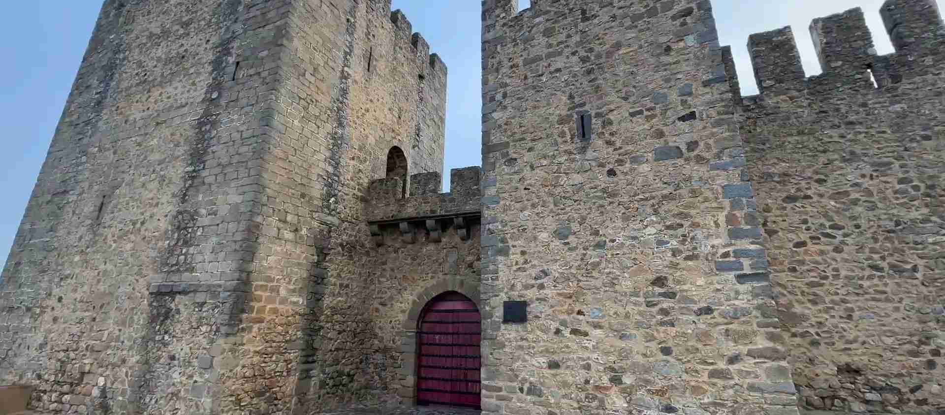
At Elvas’s highest point stands the castle, the oldest surviving fortification component dating to Moorish occupation with reconstruction by King Sancho II in 1226. The castle represents pre-artillery military architecture principles, with high walls, cylindrical towers, and a massive keep dominating the surrounding medieval town. The elevated position provided commanding views across the plains toward Spain, enabling defenders to observe approaching threats from considerable distances. This early-warning capability, combined with the castle’s formidable walls, made it the region’s strongest fortification throughout the medieval period.
The castle architecture reveals construction phases spanning centuries of military evolution. Moorish foundations incorporated Islamic military design principles, including towers positioned for overlapping fields of fire, walls adapted to rocky terrain, and a keep serving as final defensive refuge. Portuguese reconstruction after 1226 maintained these basic principles while expanding the defensive perimeter and strengthening walls to resist siege warfare tactics. Additional towers, improved gate defenses, and expanded interior space accommodated growing garrison requirements as Elvas’s strategic importance increased.
The battlements, preserved and accessible to visitors, provide spectacular panoramic views extending far into Spain. Walking the battlements offers insight into medieval defensive warfare—the wall-walk width, crenellations protecting archers, and tower positions demonstrate practical defensive planning. The views reveal why military commanders valued this position, with clear sight lines in all directions enabling early detection of approaching forces. The experience of standing on these ancient walls, looking across the same landscape medieval soldiers defended, creates powerful historical connections transcending academic understanding.
Renaissance and Baroque Architecture
Within the star fort walls exists a remarkable collection of Renaissance and Baroque religious and civil architecture, preserved in exceptional condition. The Cathedral of Nossa Senhora da Assunção (Church of Our Lady of the Assumption), built in the 16th century by Francisco de Arruda, demonstrates fortress-church architecture characteristic of frontier towns. The building’s exterior appears deliberately austere and defensive, with thick walls, limited windows, and a fortress-like profile. This design reflected practical military considerations—churches in border fortresses needed to withstand siege conditions and could serve defensive purposes if necessary.
The cathedral interior contrasts dramatically with the severe exterior, featuring extensive azulejo tile work (traditional Portuguese decorative ceramic tiles) from the 17th century. These tiles, among Portugal’s finest examples, cover walls with intricate geometric and figurative designs in blue, yellow, and white. The sacristy contains particularly exceptional tile panels depicting religious scenes. Baroque carved woodwork, marble details, and a Manueline portal under a conical dome demonstrate how religious architecture incorporated artistic excellence even in military contexts. The cathedral represents the garrison community’s cultural and spiritual life persisting despite constant military threats.
Other churches within the historic center include the Igreja das Dominicas (Dominican Church), featuring distinctive architectural elements and serving as a striking Baroque monument in Praça da República, the town’s main square. The Baroque style’s emotional intensity and decorative exuberance created dramatic contrast with military architecture’s severity, providing civilian population and garrison troops respite from warfare’s harsh realities. The Igreja de Nossa Senhora da Consolação and Igreja de São Pedro e São Paulo demonstrate additional architectural variations, with each church representing different religious orders and construction periods contributing to the town’s architectural diversity.
Military Buildings and Garrison Infrastructure
The historic center contains extensive military infrastructure converting the town into a comprehensive garrison. Barracks accommodated thousands of soldiers, with multiple buildings distributed throughout the fortified perimeter. These structures featured thick walls providing protection during bombardment, vaulted ground floors resistant to artillery impacts, and upper floors for troop quarters. The barracks architecture balanced military functionality with basic livability—adequate space, ventilation, and organization for troops who spent months or years garrisoned in Elvas.
The Military Court building, where military justice administered discipline and adjudicated disputes, stands as an impressive architectural monument reflecting military governance importance. Military commanders maintained strict discipline necessary for effective defense, with military courts enforcing regulations and punishing infractions. The building’s formal architecture emphasized authority and order, creating appropriate setting for judicial proceedings affecting soldiers’ lives and careers. Additional military administrative buildings housed staff officers, supply departments, and communications facilities coordinating defensive operations.
Arsenals and powder magazines stored weapons, ammunition, and military equipment necessary for sustained combat operations. These structures incorporated specialized design features addressing safety and security requirements. Powder magazines used extra-thick walls, isolated locations away from other buildings, lightning rods, and controlled ventilation preventing powder deterioration and explosion risks. Arsenals secured weapons and ammunition, maintaining combat readiness while preventing theft or sabotage. The comprehensive military infrastructure within the historic center demonstrates how garrison towns functioned as complete military communities encompassing all aspects of military life and operations.
Monasteries and Convents in Military Service
Several monasteries and convents within Elvas adapted to military purposes, reflecting the garrison town’s total militarization. Religious buildings’ substantial construction—thick walls, extensive interior space, secure compounds—made them suitable for military conversion during warfare. Some monasteries housed overflow garrison troops when regular barracks reached capacity. Others served as hospitals treating wounded soldiers, with religious orders providing nursing care. Monastic architecture’s organization around courtyards, with self-contained wings and controllable access points, suited military logistics including storage, accommodation, and medical facilities.
The integration of religious and military functions reflected pre-modern society’s acceptance of Church involvement in warfare. Religious orders provided chaplains for spiritual services, maintained hospitals, and contributed to garrison communities’ social fabric. The religious presence offered psychological and spiritual support crucial for troops facing combat mortality risks. Monasteries continued religious services even during sieges, maintaining community cohesion and morale. This integration of religious and military architecture, preserved within Elvas’s historic center, demonstrates how garrison towns encompassed all aspects of community life within defensive walls.
UNESCO World Heritage Significance
Criterion (iv) and Outstanding Universal Value
The UNESCO World Heritage Committee inscribed the Garrison Border Town of Elvas on the World Heritage List in 2012 under criterion (iv), which recognizes properties that represent outstanding examples of architectural or technological ensembles or landscapes illustrating significant stages in human history. The Committee determined that Elvas demonstrates outstanding universal value through its comprehensive and exceptionally preserved fortification system representing the largest and most sophisticated bulwarked dry-ditch system ever constructed, incorporating military engineering innovations that influenced fortress design worldwide.
The Statement of Outstanding Universal Value emphasizes multiple dimensions establishing Elvas’s significance. The fortifications represent the culmination of the Dutch school of military engineering, with geometric planning, mathematical precision in bastion design, and comprehensive defensive outworks creating an integrated system optimized for artillery-age warfare. The exceptional preservation of the complete defensive network, including the main bastioned walls, two major satellite forts, three fortlets, connecting military roads, and the monumental aqueduct, provides unparalleled insight into how comprehensive fortress systems functioned as integrated defensive networks rather than isolated strongpoints.
The garrison town itself, preserved within the fortifications, demonstrates the complete urban community created by military necessity. The combination of medieval castle, Renaissance churches, Baroque religious architecture, extensive military infrastructure, and civilian buildings reveals how fortress towns functioned as complex communities balancing military requirements with civilian life. The architectural and urban planning adaptation to perpetual military threat, creating a self-sufficient garrison capable of withstanding prolonged sieges while maintaining community cohesion, represents unique heritage worthy of international protection and recognition.
Authenticity and Integrity
The World Heritage designation required demonstrating both authenticity (genuine historical character without inappropriate alterations) and integrity (completeness of the property encompassing all elements necessary to express outstanding universal value). Elvas meets both requirements at the highest level. The fortifications retain their original materials, design, and form throughout most of the defensive network. Construction techniques, stone masonry, earthwork fortifications, and architectural details remain authentic to their construction periods, enabling visitors and researchers to experience genuine 17th-18th century military architecture.
The integrity requirement—ensuring the property encompasses all elements necessary to demonstrate its significance—drove the decision to include seven distinct components in the World Heritage designation: the Historic Centre containing the medieval castle, Renaissance walls, and garrison buildings; the Amoreira Aqueduct providing strategic water supply; the Fort of Santa Luzia with its connecting military road; the Fort of Graça commanding the northern heights; and the three fortlets (São Mamede, São Pedro, São Domingos) completing the defensive ring. This comprehensive approach recognizes that Elvas’s outstanding universal value resides not in individual components but in the complete integrated defensive system demonstrating how military planners created comprehensive fortress networks.
The 179-hectare property encompasses all major fortification components, with a substantial 690-hectare buffer zone protecting views, setting, and approaches. This buffer zone prevents modern development from compromising the fortifications’ visual integrity or obscuring their strategic geography. Visitors experience Elvas much as 18th-century military observers would have—star-shaped bastions commanding elevated positions, satellite forts on surrounding hills, the monumental aqueduct striding across valleys, and the defensive geometry clearly readable in the landscape.
International Comparative Analysis
The World Heritage evaluation process included comparative analysis with other fortified properties worldwide, assessing whether Elvas possessed unique characteristics warranting international designation. The analysis examined European fortified towns including Vauban fortifications in France, Dutch water defense systems, Italian Renaissance fortifications, and other artillery-age fortress systems. This comparison established that while many excellent fortifications survive worldwide, none equals Elvas’s combination of scale, preservation, architectural innovation, and comprehensive defensive integration.
French military engineer Sébastien Le Prestre de Vauban (1633-1707) created numerous fortifications representing the French school of military engineering, with several Vauban sites designated as World Heritage properties. However, Vauban’s works, while brilliant, represent a different engineering tradition emphasizing different principles. The Dutch school engineering at Elvas incorporated mathematical geometric planning more rigorously, created the world’s largest bulwarked dry-ditch system rather than Vauban’s preference for wet moats where practical, and integrated satellite forts more comprehensively into defensive networks. The comparison established Elvas as complementary rather than redundant to Vauban fortifications, representing a distinct engineering tradition worthy of independent recognition.
The Dutch water defense systems in the Netherlands, also World Heritage properties, demonstrate different defensive principles adapted to low-lying terrain where controlled flooding created defensive obstacles. Elvas’s elevated position and dry-ditch system represent the alternative approach for defending elevated terrain where water defenses proved impractical. The comparative analysis concluded that these different defensive strategies, each adapted to specific geographic contexts, both merit World Heritage recognition as representing distinct but equally significant military engineering traditions.
Italian Renaissance fortifications influenced early artillery-age fortress design throughout Europe. However, the progression from Italian Renaissance principles to fully developed Dutch school engineering, demonstrated at Elvas through continuous evolution from 1640s construction through 18th-century satellite forts, provides historical documentation of military engineering’s development unavailable in properties representing single construction periods. The temporal depth combined with exceptional preservation and unprecedented scale established Elvas’s unique position justifying World Heritage designation.
Portuguese Independence and Military History
Restoration War Context
The Portuguese Restoration War (1640-1668) provides essential historical context for understanding Elvas’s fortification development. In 1580, Portugal came under Spanish Habsburg rule following a succession crisis, losing its independence for 60 years. Portuguese nobility, merchants, and common people increasingly resented Spanish rule, which subordinated Portuguese interests to Spanish imperial priorities and involved Portugal in Spain’s numerous European conflicts. On December 1, 1640, Portuguese conspirators executed a coup in Lisbon, deposing the Spanish-appointed administrators and proclaiming João IV as King of Portugal.
The restoration immediately provoked Spanish military response. Spain, despite being embroiled in the Thirty Years’ War and Dutch Revolt, could not accept Portuguese independence without military challenge. Spanish military strategy focused on quickly recapturing Portugal before the new kingdom could organize effective defenses. This strategy identified Elvas as the crucial gateway—Spanish forces based in Extremadura could advance from Badajoz through Elvas toward Lisbon, conquering Portugal along the historic invasion route.
Portuguese military planners recognized Elvas’s strategic importance matched its vulnerability. The existing medieval fortifications, while formidable by medieval standards, could not resist modern artillery-based siege warfare. Spanish artillery would demolish medieval walls relatively quickly, enabling assault and capture. The Portuguese crown therefore prioritized modernizing Elvas’s fortifications above all other defensive projects. The massive investment in hiring Cosmander and constructing state-of-the-art star fort fortifications reflected accurate assessment that Portugal’s independence survival depended on blocking Spanish advance routes through modernized border fortresses.
The 1658-1659 Spanish Siege
The 1658-1659 siege of Elvas represented the Restoration War’s crucial test—Spanish forces’ last major attempt to break Portuguese defensive systems and advance toward Lisbon. Spanish commander Don Luís de Haro assembled overwhelming forces, significantly outnumbering the Elvas garrison and civilian population. Spanish military engineers conducted formal siege operations following contemporary siege warfare doctrine: establishing entrenchments encircling the fortress, constructing artillery batteries for bombardment, digging approach trenches advancing toward the walls, and preparing assault forces for breaching once bombardment created practical gaps.
The modern fortifications performed exactly as Dutch military engineering theory predicted. Spanish artillery bombardment, while sustained and intense, failed to create practical breaches in the bastioned walls. The thick earthwork and masonry construction absorbed artillery impacts, with damage quickly repaired by the garrison during bombardment pauses. Spanish approach trenches faced devastating artillery and musket fire from bastion positions, suffering heavy casualties for minimal progress. Spanish assault attempts against ravelins and advanced works encountered crossfire from multiple defensive positions, with attack columns decimated before reaching main walls.
The Amoreira Aqueduct proved its strategic value by maintaining water supply throughout the siege. Spanish forces could not effectively cut the water supply without detaching substantial forces to capture and hold the distant source area, weakening the main siege force. The garrison and civilian population maintained adequate water, hygiene, and morale despite months of encirclement. Portuguese relief forces eventually maneuvered to threaten Spanish lines of communication, forcing Spanish withdrawal after sustaining heavy casualties and achieving minimal progress.
The Spanish failure at Elvas proved decisive for Portuguese independence. Spain, facing military commitments throughout Europe and unable to breach modernized Portuguese border fortresses, effectively conceded Portuguese independence through exhaustion. The 1668 Treaty of Lisbon formally recognized Portuguese sovereignty, ending the Restoration War. Elvas’s successful resistance directly contributed to this outcome—Spanish inability to advance through the border gateway demonstrated that reconquering Portugal would require resources Spain could not commit. The fortifications justified their massive construction costs by fulfilling their ultimate purpose: deterring conquest and preserving independence.
Peninsular War and Napoleonic Conflicts
Elvas gained renewed military importance during the Peninsular War (1807-1814) when Napoleon’s forces invaded Portugal and Spain, prompting British military intervention supporting Portuguese and Spanish resistance. The fortifications, while designed for Portuguese-Spanish conflicts, proved equally effective against French forces employing the era’s most advanced military tactics and technology. British forces under Arthur Wellesley (later Duke of Wellington) recognized Elvas’s strategic value, establishing major operational bases and hospitals within the fortress.
The fortress served particularly crucial roles during the sieges of Badajoz in 1811 and 1812, when British and Portuguese forces besieged the Spanish border city held by French troops. Elvas provided the operational base for siege operations, with troops, artillery, supplies, and hospitals concentrated in the fortress. The fortifications protected these assets from French relief attempts while the siege forces conducted operations against Badajoz. The successful captures of Badajoz, achieved after bloody fighting and extensive casualties, opened central Spain to Allied operations and contributed significantly to eventual French expulsion from the Iberian Peninsula.
The Peninsular War experience demonstrated that early 19th-century military technology had not rendered 17th-18th century star fort fortifications obsolete. The geometric precision, comprehensive defensive outworks, and integrated defensive systems developed through Dutch military engineering remained effective against contemporary siege warfare. This longevity—fortifications designed in the 1640s remaining militarily relevant into the 1810s—testified to the fundamental soundness of Dutch school military engineering principles. The fortifications continued serving Portuguese military forces throughout the 19th century, with garrisons maintained and defensive readiness preserved even as military technology gradually evolved beyond fixed fortification effectiveness.
Visiting Elvas: Exploring the Fortifications
Castle and Main Fortifications
The Elvas Castle provides the essential starting point for exploring the fortification system. The castle opens daily from 9:30 AM to 5:30 PM, closing briefly around lunchtime following Portuguese customs. General admission costs €2, with the modest fee supporting preservation maintenance. The castle entrance leads through massive gates into the medieval fortress interior, where preserved walls, towers, and the keep reveal military architecture predating the star fort system. The battlements, accessible via steep stone staircases, offer panoramic views across the town and surrounding plains extending far into Spain.
Walking the battlements provides essential geographic orientation for understanding the fortification system’s strategic logic. Visitors can identify the Fort of Graça on northern heights, Fort of Santa Luzia to the southeast, the Amoreira Aqueduct’s distinctive arches to the west, and the bastion walls encircling the historic center. The elevated perspective reveals how defensive positions interconnected through overlapping fields of fire and how the terrain influenced fortification design. The battlements’ narrow width, steep drop on both sides, and original crenellations create visceral understanding of medieval defensive warfare’s physical reality.
The main bastion walls surrounding the historic center remain largely intact and accessible for exploration. Multiple gates pierce the fortifications, each demonstrating defensive design principles. The gates feature indirect approaches forcing visitors through controlled passages within defensive walls, with flanking positions providing crossfire coverage. Some gates preserve original architectural details including stone carvings, coats of arms, and decorative elements adding aesthetic refinement to military architecture. Walking portions of the walls and examining bastion structures reveals the massive scale—walls 10-15 meters thick, deep dry ditches, sophisticated masonry construction, and geometric precision in planning.
Fort of Graça Experience
The Fort of Graça, located approximately 2 kilometers north of the historic center, represents Elvas’s most impressive individual fortification. The fort opens regularly for visits, with general admission costing €5. Guided tours provide deeper insight into the fort’s military history, architecture, and defensive systems. The approach to the fort follows the original military road, offering views of the fort’s geometric star-shape becoming increasingly impressive as visitors draw closer.
Entering the fort through its massive gate demonstrates defensive planning sophistication. The entrance passage forces visitors through multiple controlled points, with defensive positions commanding each turn. Once inside, visitors access the central courtyard surrounded by vaulted casemates. These underground chambers, with thick vaulted ceilings designed to resist artillery bombardment, housed garrison troops, stored ammunition, and protected artillery. The chambers’ architecture—precise stone vaulting, adequate ventilation despite underground location, organized spaces for different military functions—reveals engineering sophistication creating livable protected military space.
Walking the ramparts provides spectacular views commanding the surrounding terrain. The elevated position explains why military planners invested heavily in this satellite fort—the views extend far into Spain, with every approach route visible from defensive positions. The artillery terrepleins preserve gun positions where defenders mounted cannon covering all approaches. The traverse walls, compartmentalizing defensive positions, demonstrate how engineers protected against enfilade fire. The complete circuit of the ramparts, possible for visitors, covers approximately 1 kilometer, with interpretive materials explaining defensive features and historical events.
Fort of Santa Luzia and Military Road
The Fort of Santa Luzia, positioned southeast of the historic center, offers different but equally valuable perspectives on the fortification system. While less geometrically perfect than Fort of Graça due to its evolutionary construction history, Santa Luzia demonstrates how military engineers adapted fortification principles to existing terrain and structures. The fort includes a military museum displaying weaponry, uniforms, equipment, and documents illuminating garrison life and military operations throughout the fortifications’ active service period.
The covered military road connecting Santa Luzia to the main fortifications provides unique insight into integrated defensive systems. This protected route, approximately 1.5 kilometers long, enabled troop movements between fort and town without enemy exposure. Walking this military road, with its defensive walls and strategic firing positions, demonstrates how military planners created comprehensive defensive networks rather than isolated strongpoints. The road’s preservation allows visitors to experience military infrastructure as 18th-century soldiers used it, creating direct connection to historical experience.
The fort’s Governor’s House and Chapel of Santa Luzia preserve military architecture adapted to command and spiritual functions. The Governor’s House demonstrates how military commanders balanced authority representation with practical command facility requirements. The chapel’s integration of religious architecture within a military fortress reveals garrison community values and how spiritual life continued despite perpetual military threats. These structures, preserved in substantial original condition, provide insight into military life’s human dimensions beyond defensive engineering and warfare tactics.
Amoreira Aqueduct Appreciation
The Amoreira Aqueduct stands as one of Elvas’s most photographed monuments, with its five-tiered arches creating distinctive architectural profiles particularly dramatic during golden hour lighting. The aqueduct remains functional, with water still flowing through the historic channel four centuries after completion. Visitors can access various vantage points offering different perspectives on the structure’s impressive engineering and aesthetic qualities.
The aqueduct’s western approach, where it begins rising into multi-tiered arches to cross valleys, provides excellent photographic opportunities. The massive cylindrical buttresses reinforcing the structure are particularly impressive here, with their scale and engineering purpose clearly visible. Visitors can walk beneath the lowest arches, experiencing the structure’s monumental scale and examining construction details including masonry joints, arch proportions, and foundation work. The engineering sophistication becomes apparent through close examination—the precise stone cutting, structural calculations enabling such heights, and centuries of successful functioning despite minimal maintenance.
The aqueduct’s integration into the town occurs near the historic center, where the water channel terminates in distribution facilities. This eastern terminus area demonstrates how the aqueduct functioned as practical infrastructure, not merely monumental architecture. The water distribution systems, cisterns, and channels served military and civilian water needs, with the infrastructure’s organization revealing hydraulic engineering understanding. The aqueduct’s dual nature—both impressive architectural monument and practical military infrastructure—exemplifies how military necessity drove engineering achievements creating lasting heritage beyond their original purpose.
Architectural Details and Military Engineering Features
Bastion Construction and Design Elements
The bastions forming the core of Elvas’s fortification system demonstrate sophisticated construction techniques combining earthwork and masonry. The typical bastion begins with excavated dry ditches, typically 10-15 meters deep and 20-30 meters wide, creating the primary obstacle. Excavated material from ditch-digging provides fill for rampart construction behind, creating the elevated platforms where defenders positioned artillery and infantry. This earth-moving efficiency—using ditch excavation material for rampart construction—reduced construction costs while creating complementary defensive elements.
The rampart construction employed rammed earth techniques creating stable foundations, topped with thick masonry walls facing both the interior town and exterior field. The exterior masonry face, called the escarpment, presented a vertical or near-vertical obstacle to attackers who crossed the dry ditch. The masonry’s substantial thickness, typically 2-3 meters, resisted artillery bombardment while providing structural support for the earth fill behind. The interior face, called the revetment, retained the earth fill while providing finished wall appearance for the town side. This sandwich construction—masonry-earth-masonry—combined strength, stability, and construction economy.
Bastion angles followed precise geometric calculations derived from artillery ballistics and musket ranges. The salient angle (the bastion’s pointed tip) typically measured 60-70 degrees, balancing the concentration of defensive fire against making individual bastions too large to defend effectively. The flanks, where bastions connected to curtain walls, positioned perpendicular to adjacent curtain walls, enabling flanking fire along those walls’ length. This geometric precision ensured that every point of the curtain walls fell within musket range from bastion flanks, creating killing zones where attackers faced crossfire from multiple positions simultaneously.
Counterscarp and Covered Way Systems
The counterscarp walls—vertical masonry walls rising from dry ditch outer edges—provided crucial secondary defensive lines. These walls, typically 5-8 meters high, prevented attackers who descended into ditches from easily scaling the opposite side and reaching main walls. The counterscarp construction required substantial excavation and masonry work, with foundations extending deep into bedrock ensuring stability despite the artificial vertical faces. The tops of counterscarp walls formed the covered ways—protected paths where defenders could occupy forward positions during sieges.
The covered ways incorporated sophisticated defensive features maximizing their utility. The paths typically measured 10-15 meters wide, providing adequate space for troop movements, artillery positioning, and defensive fighting. Parapets protected the outer edge, shielding defenders from direct fire while allowing them to fire over the parapet toward approaching enemies. Places of arms—widened sections at bastioned angles in the covered way—provided rally points for sorties, assembly areas for counterattacks, and positions for reserve troops. These wider areas could accommodate substantial forces preparing offensive actions against siege works.
Beyond the covered ways, the glacis extended the defensive zone into the surrounding field. This carefully graded slope, cleared of all obstacles and vegetation, provided defenders on walls and covered ways clear fields of fire while denying attackers any cover. The glacis gradient calculation reflected ballistics understanding—too steep and artillery shot would fly over attackers’ heads; too gentle and attackers could shelter in folds of ground. Military engineers determined optimal angles through mathematical analysis and practical experience, creating glacis slopes that maximized defensive fire effectiveness while minimizing dead ground where attackers could shelter.
Ravelins and Advanced Works
The ravelins—detached triangular fortifications positioned in front of curtain walls—added defense-in-depth to the fortification system. These structures, smaller than full bastions but substantial defensive works in their own right, served multiple purposes. They provided advanced firing positions commanding approaches between main bastions, complicating siege operations by creating additional strong points requiring capture. Their placement in front of curtain walls protected those walls from direct artillery bombardment, as attackers had to capture or neutralize ravelins before effectively engaging main walls.
Ravelin construction followed similar principles to bastions but on reduced scale. Each ravelin featured its own dry ditch, typically 6-10 meters deep, with counterscarp walls and covered ways creating miniature defensive systems. The ravelin interior, called the terreplein, provided elevated platform for artillery and infantry positions. Connection to main fortifications occurred via protected passages crossing the main dry ditch, allowing garrison troops to reinforce ravelins or withdraw to main walls as tactical situations required. These passages, often underground or protected by earthworks, prevented attackers from isolating ravelins even after capturing surrounding terrain.
The geometric relationships between ravelins and bastions reflected sophisticated spatial planning. Ravelins positioned to maximize protective effect on curtain walls while remaining within supporting fire range from adjacent bastion flanks. This mutual support principle—each defensive element positioned to support others—eliminated isolated defensive positions vulnerable to overwhelming attack. An enemy focusing artillery on a ravelin faced fire from flanking bastions; forces assaulting a bastion encountered fire from adjacent ravelins. This integrated defensive network, with each element supporting others through geometric relationships, demonstrates the mathematical sophistication underlying Dutch military engineering.
Cultural Significance and Heritage Conservation
Portuguese National Identity and Military Heritage
Elvas holds profound significance for Portuguese national identity, representing the successful defense of independence against Spanish reconquest attempts. The fortifications embody Portugal’s determination to maintain sovereignty despite facing a larger, more powerful neighboring kingdom. This historical narrative resonates deeply in Portuguese culture, where the Restoration War period represents a defining moment when Portuguese society united to preserve independence. The fortifications stand as physical monuments to that collective effort, the massive construction investment reflecting national commitment to freedom.
The garrison town preserved within the fortifications demonstrates military community culture that developed during centuries of border defense duties. The soldiers stationed at Elvas—drawn from throughout Portugal and sometimes foreign military contractors—created distinctive military society balancing martial discipline with civilian community life. The churches, monasteries, barracks, and civil buildings within the walls reveal how military and civilian spheres integrated, with garrison troops participating in religious festivals, local markets, and community governance while maintaining military readiness.
Portuguese military tradition honors Elvas as a symbol of defensive excellence and strategic thinking. Portuguese military academies study the fortifications as exemplars of military engineering and strategic planning. The successful defense during the 1658-1659 siege appears in military history texts as demonstrating how well-designed fortifications, competent garrison leadership, and resolute defense can defeat superior numbers. This military heritage continues influencing Portuguese armed forces’ professional culture, with Elvas representing ideals of preparation, determination, and effective defense.
Conservation Challenges and Preservation Efforts
Preserving the massive Elvas fortification complex presents substantial technical and financial challenges. The property encompasses 179 hectares of fortifications, buildings, and defensive works requiring continuous maintenance. Stone masonry deteriorates through weathering, vegetation growth damages walls, earthworks erode without regular maintenance, and structural movement threatens historic buildings. The scale demands systematic conservation planning, professional expertise, sustained funding, and coordinated management addressing competing conservation priorities.
Portuguese cultural heritage authorities, working with international conservation experts and UNESCO advisory bodies, developed comprehensive conservation management plans. These plans prioritize interventions based on urgency, historical significance, and available resources. Critical structural repairs preventing collapse take priority over aesthetic restoration. Conservation work employs traditional materials and techniques matching original construction methods, ensuring repairs integrate visually and structurally with historic fabric. Skilled stonemasons, using lime mortar and locally-quarried stone matching original materials, repair masonry walls maintaining architectural authenticity.
Vegetation management represents ongoing conservation challenges. Trees, shrubs, and aggressive plants colonize walls and earthworks, with roots damaging masonry and destabilizing structures. Regular vegetation clearance prevents damage while maintaining the fortifications’ visual clarity—overgrown fortifications lose their architectural legibility and strategic logic becomes obscured. However, some vegetation provides erosion control for earthwork slopes, requiring careful judgment balancing preservation needs. Conservation teams develop vegetation management plans specifying which areas require complete clearance versus selective vegetation retention for slope stability.
Community Engagement and Educational Programs
Successful World Heritage site conservation requires community support and engagement. Elvas’s local population, living within and around the fortifications, directly affects preservation outcomes through their daily interactions with the heritage site. Conservation authorities developed educational programs building community understanding of the fortifications’ international significance and the conservation principles guiding preservation efforts. School programs introduce children to Elvas’s history and heritage values, creating generational continuity in heritage appreciation.
The fortifications contribute substantially to Elvas’s economy through heritage tourism. Visitors attracted by the UNESCO designation support local hotels, restaurants, shops, and tour services, creating economic incentives for preservation. This tourism must balance heritage preservation with economic development—increased visitation generates revenue supporting conservation but also creates wear on historic structures, requires visitor infrastructure potentially impacting historic character, and demands interpretation services explaining the site’s significance.
Local heritage organizations, including volunteer groups and historical societies, complement official conservation efforts. These organizations organize guided tours sharing local knowledge and historical narratives, maintain archives documenting fortification history, and advocate for preservation priorities. Community-based conservation initiatives demonstrate how heritage sites become integrated into community identity rather than merely tourist attractions or government-managed monuments. This integration increases preservation sustainability by creating broad-based support extending beyond professional conservators and government agencies.
Frequently Asked Questions About Elvas Star Fort Heritage
When Were the Elvas Fortifications Built and Why?
The current star fort fortifications began construction in 1643, three years after Portugal regained independence from Spanish rule in 1640. Following the Portuguese Restoration, military planners recognized that existing medieval fortifications could not resist modern artillery-based siege warfare that Spanish forces would employ in reconquest attempts. The strategic importance of Elvas, controlling the primary invasion route between Spain’s capital Madrid and Portugal’s capital Lisbon, justified massive investment in state-of-the-art fortifications. Construction continued in phases through the 19th century, with the main bastioned walls completed during the Restoration War period (1640-1668) and major satellite forts added in the 18th century. The Fort of Graça, the fortification system’s final major component, was constructed between 1763 and 1792. The earlier medieval castle dates to Moorish occupation with reconstruction by Portuguese King Sancho II in 1226, while the historic town contains architectural elements from multiple periods creating layers of fortification representing nearly a millennium of military evolution.
What Makes Elvas the World’s Largest Bulwarked Dry-Ditch System?
Elvas holds the distinction as the world’s largest bulwarked dry-ditch fortification system through the combination of scale, defensive sophistication, and comprehensive integration of multiple fortification components. The main bastion walls encircle the historic center with twelve major bastions forming an irregular polygon approximately 3 kilometers in perimeter, all fronted by deep dry ditches typically 10-15 meters deep and 20-30 meters wide backed by counterscarp walls. The defensive system extends beyond the main walls to include the Fort of Graça and Fort of Santa Luzia positioned on commanding hilltops, three smaller fortlets filling defensive gaps, connecting military roads, and extensive outworks including ravelins, covered ways, and glacis. This comprehensive network covers approximately 179 hectares of fortified property with an additional 690-hectare buffer zone, creating an integrated defensive system unprecedented in scale and sophistication. The dry-ditch approach, chosen due to Elvas’s elevated terrain and water source limitations, developed more extensively here than anywhere else, with the comprehensive counterscarp systems, caponiers, and ditch defense positions representing the culmination of dry-ditch military engineering.
Can Visitors Walk the Fortification Walls and Explore the Forts?
Yes, substantial portions of the Elvas fortification system remain accessible for visitor exploration. The medieval castle opens daily from 9:30 AM to 5:30 PM with admission costing €2, providing access to the battlements offering panoramic views across the fortress and surrounding plains. Many sections of the main bastion walls encircling the historic center can be walked, with multiple gates and defensive positions accessible. The Fort of Graça opens regularly for visits with general admission at €5, allowing exploration of the ramparts, vaulted casemates, central courtyard, and defensive features. Guided tours provide deeper insight into the fort’s military history and architectural significance. The Fort of Santa Luzia houses a military museum displaying weapons, uniforms, and equipment while preserving the Governor’s House and chapel for visitor exploration. The covered military road connecting Santa Luzia to the main fortifications can be walked, offering unique perspective on integrated defensive systems. The Amoreira Aqueduct, while not a fortification proper, allows walking beneath its massive arches and examining the engineering. Some fortification areas remain restricted for safety or conservation reasons, but the extensive accessible portions provide comprehensive understanding of the defensive system’s scope and sophistication.
How Long Does It Take to Thoroughly Explore Elvas?
A thorough exploration of Elvas’s fortifications and historic center requires a full day minimum, with two days recommended for comprehensive experience. A single-day visit typically includes the medieval castle with battlements exploration (1-2 hours), walking through the historic center visiting the cathedral and other churches (2-3 hours), examining sections of the main bastion walls and gates (1 hour), viewing the Amoreira Aqueduct (30 minutes to 1 hour), and visiting one satellite fort—typically the Fort of Graça (2 hours including travel from the center). This schedule provides overview understanding but necessarily omits some sites and limits time for detailed examination. A two-day visit allows exploring both major satellite forts, walking greater lengths of the bastion walls, visiting military museums, joining guided tours providing historical context, and appreciating the fortifications at different times of day for optimal photography and understanding. The fortifications’ massive scale means that even two days covers only highlights—military history enthusiasts, architecture students, or photography specialists could productively spend three or more days examining different aspects, capturing various perspectives, and developing deep understanding of the defensive systems and their historical contexts.
What Historical Events Did Elvas’s Fortifications Witness?
The Elvas fortifications witnessed numerous pivotal historical events spanning five centuries of military history. The most significant occurred during the Portuguese Restoration War (1640-1668), particularly the massive Spanish siege of 1658-1659 when Spanish forces under Don Luís de Haro attempted to capture the fortress and open the route to Lisbon. The fortifications’ successful resistance during this prolonged siege, enabled by the modern bastion design and the Amoreira Aqueduct maintaining water supply, contributed directly to Portuguese independence preservation. During the Peninsular War (1807-1814), Elvas served as a major operational base and hospital supporting British and Portuguese forces fighting Napoleon’s armies, with particular importance during the 1811 and 1812 sieges of nearby Badajoz. The fortress provided secure staging area for these operations while its hospitals treated thousands of wounded soldiers from the brutal fighting. Throughout its active military service period extending into the late 19th century, Elvas housed garrisons defending Portuguese independence, deterring Spanish military adventures through its formidable defensive presence. The fortifications also witnessed numerous diplomatic missions, royal visits, and military reviews where Portuguese monarchs inspected their border defenses. The comprehensive preservation allows visitors to walk the same ramparts, examine the same defensive positions, and experience the same commanding views that historical figures encountered, creating direct connections to European military history’s pivotal moments.
Why Did Military Engineers Choose Elvas for Portugal’s Major Border Fortress?
Multiple strategic factors converged making Elvas the obvious choice for Portugal’s primary border fortress. Geographic positioning placed Elvas directly on the invasion route between Spain’s capital Madrid and Portugal’s capital Lisbon, with all east-west traffic necessarily passing through this corridor. The elevated terrain provided naturally defensible positions with commanding views across surrounding plains extending far into Spanish territory, enabling early warning of approaching forces. The proximity to the Spanish border (less than 15 kilometers) meant Elvas could serve both defensive purposes—blocking invasion routes—and offensive purposes—serving as a staging base for Portuguese operations into Spain. The site’s existing fortifications dating to Roman, Moorish, and medieval Portuguese periods demonstrated centuries of recognized strategic value and provided foundations for expansion rather than requiring entirely new construction. Water availability from local sources enabled construction of the Amoreira Aqueduct solving the critical siege warfare challenge of sustaining water supply during prolonged encirclement. The surrounding hilltops, while creating potential vulnerabilities if occupied by enemies, also provided positions for satellite forts creating an integrated defensive network. These geographic, strategic, and logistical factors combined to make Elvas not merely a logical choice but the essential choice for Portugal’s border defense investment following the 1640 Restoration of Independence.
How Did the Fortifications Influence European Military Architecture?
Elvas’s fortifications influenced European military architecture through demonstrating Dutch school engineering principles applied at unprecedented scale with exceptional results. The fortress became a model studied by military engineers throughout Europe, with its geometric precision, comprehensive defensive outworks, and integrated satellite fort system representing best practices in artillery-age fortification design. Portuguese military engineers trained at Elvas carried this knowledge to other fortification projects in Portugal and Portuguese colonial territories in Brazil, Africa, and Asia, spreading Dutch-influenced design principles globally. The successful defense during the 1658-1659 Spanish siege provided empirical validation of Dutch military engineering theory, demonstrating that mathematically-planned bastioned fortifications could resist sustained siege operations by contemporary Europe’s most powerful armies. This battlefield success influenced military thinking throughout Europe, reinforcing the shift from medieval height-and-thickness defensive principles to geometric planning and overlapping fields of fire. The comprehensive integration of satellite forts into an overall defensive network, exemplified by Elvas’s Fort of Graça and Fort of Santa Luzia, established models for defense-in-depth systems controlling strategic terrain through multiple mutually-supporting strongpoints. Military engineering texts and academy curricula throughout 18th and 19th century Europe referenced Elvas as an exemplary fortress, with the fortifications’ scale, sophistication, and proven effectiveness making them standard examples when teaching fortification principles to new generations of military engineers.
What Role Did Dutch Engineers Play in Designing Elvas?
Dutch military engineering expertise proved crucial to Elvas’s transformation from medieval castle town to modern star fortress. Following Portugal’s 1640 restoration of independence, Portuguese military planners recognized their need for advanced fortification knowledge to resist Spanish reconquest attempts. The Netherlands had developed Europe’s most sophisticated fortification science through decades of warfare against Spanish forces, with Dutch engineers including Simon Stevin and Menno van Coehoorn pioneering mathematical approaches to bastion design, defensive geometry, and comprehensive outwork systems. Portugal contracted Dutch Jesuit padre João Piscásio Cosmander, trained in this Dutch military engineering tradition, to design Elvas’s modernization beginning in 1643. Cosmander brought geometric planning principles, mathematical precision in bastion angle calculations, dry-ditch system expertise, and comprehensive understanding of artillery ballistics and siege warfare tactics. His designs for Elvas incorporated every advanced principle of Dutch fortification science, creating what became the largest and most sophisticated application of Dutch engineering principles anywhere. Additional Dutch engineers including John Gillot contributed to construction supervision and design refinement during the intensive building period of the 1640s-1650s. The Dutch influence extended beyond technical design to encompass strategic thinking about integrated defensive networks, satellite fort positioning, and defense-in-depth principles that characterized Elvas’s overall conception. This Dutch engineering legacy explains why Elvas represents not merely a large fortress but the finest surviving example of Dutch school military architecture, embodying theoretical principles developed in the Low Countries and applied at unprecedented scale in Portugal’s border defense.
How Does the Amoreira Aqueduct Demonstrate Military Engineering Beyond Fortifications?
The Amoreira Aqueduct demonstrates how military engineering encompassed comprehensive logistical infrastructure supporting sustained combat operations, extending far beyond walls and artillery positions. The aqueduct’s construction, spanning 1498-1622, preceded the star fort fortifications but military planners recognized its strategic value during the 1640s fortification design phase. Siege warfare frequently succeeded through attrition rather than assault, with besieging forces cutting supplies including water until defenders surrendered from deprivation. The aqueduct eliminated this vulnerability by providing reliable water from sources beyond besieging forces’ control, enabling Elvas to withstand prolonged encirclement without water shortage forcing capitulation. The engineering sophistication required to construct a 7-kilometer gravity-flow system maintaining consistent gradient across irregular terrain, crossing deep valleys with five-tiered arches rising 31 meters, and incorporating 843 arches while ensuring structural stability matched the sophistication of the bastion fortifications themselves. The aqueduct’s robust stone construction, massive cylindrical buttresses, and integration into the overall defensive strategy demonstrated military planners’ understanding that successful fortress defense required not only strong walls but comprehensive logistical infrastructure supporting garrison and civilian populations under siege conditions. The structure’s continuing functionality after four centuries demonstrates that sound engineering principles applied to military logistics created enduring infrastructure serving communities long after military threats ceased. The aqueduct stands as monument to the principle that military success depends on integrated systems addressing all operational requirements rather than focusing narrowly on combat capability alone.
What Conservation Challenges Does UNESCO World Heritage Designation Address?
The UNESCO World Heritage designation addresses multiple conservation challenges through creating international recognition, establishing conservation standards, providing expert technical support, and generating political and financial commitment to preservation. Prior to the 2012 designation, conservation funding competed with numerous other Portuguese governmental priorities, with limited resources constraining preservation efforts. The World Heritage status elevated Elvas’s conservation priority, attracting increased national government funding, European Union heritage program grants, and international conservation organization support. The designation process required developing comprehensive management plans identifying conservation needs, establishing monitoring systems tracking condition changes, and creating governance structures coordinating various stakeholder responsibilities. These management frameworks provide systematic approaches addressing the fortifications’ vast scale and complexity rather than ad hoc repairs responding to crises. UNESCO advisory bodies including ICOMOS (International Council on Monuments and Sites) provide technical expertise on conservation methodologies, traditional materials, and intervention approaches respecting historical authenticity while ensuring structural stability. The international visibility generates awareness attracting heritage conservation specialists, researchers, and professionals contributing specialized knowledge addressing specific challenges including stone masonry deterioration, earthwork erosion, and structural movement. The World Heritage status also increases heritage tourism generating economic resources supporting conservation through visitor admission fees, local tax revenues, and heritage tourism multiplier effects. This economic dimension creates sustainability by linking conservation funding to visitor appreciation rather than depending solely on government appropriations vulnerable to budget pressures. The designation ultimately transforms conservation from isolated Portuguese national concern to internationally significant heritage requiring coordinated efforts drawing on global expertise and resources.