Step into a world where history, engineering, and adventure collide. The Qapaq Ñan—an expansive road system built by the Inca Empire—stretches over 24,000 miles across six South American countries. This ancient network connected remote settlements, enabled cultural exchange, and showcased remarkable engineering techniques that still awe modern travelers.
Imagine walking paths lined with perfectly fitted stone slabs, climbing through misty cloud forests, or discovering archaeological wonders like Ingapirca. The trail isn’t just a relic—it’s a living gateway to indigenous traditions and breathtaking landscapes. Whether you’re a history buff or thrill-seeker, this guide unlocks everything from its UNESCO World Heritage status to practical tips for exploring its routes.
Why does this matter today? Local communities actively preserve the trail while sharing their heritage through guided hikes and cultural experiences. You’ll learn how centuries-old construction methods supported an empire and how modern travelers can tread respectfully along these sacred paths.
Key Takeaways
- Spanning six countries, the Inca road system covers over 24,000 miles of diverse terrain.
- Engineers built durable stone pathways without mortar, showcasing advanced techniques.
- UNESCO recognition highlights its global cultural and historical importance.
- Hikers encounter archaeological sites, biodiverse ecosystems, and local traditions.
- Modern conservation efforts blend tourism with community-led preservation.
- Contact us for a comfortable and personalized itinerary (Free Service)
Introduction to the Qapaq Ñan
Imagine a 25,000-mile web of pathways stitching together mountains, deserts, and jungles. This engineering masterpiece—once the backbone of South America’s largest empire—connected distant communities through trade, faith, and military strategy. Its stone-paved routes crossed six modern nations, enabling rapid communication long before modern infrastructure.
Lifeline of a Thriving Civilization
The road system unified over 100 distinct cultures under Inca rule. Messengers called chasquis relayed commands across peaks, while llama caravans transported goods like maize and textiles. Strategic rest stops called tambos provided shelter for travelers navigating harsh terrains.
| Trail Feature | Purpose | Modern Access |
|---|---|---|
| Stone stairways | Mountain traversal | Hiking routes in Peru |
| Suspension bridges | River crossings | Reconstructed sites in Ecuador |
| Sacred shrines | Religious ceremonies | Guided cultural tours |
Why Explorers Should Care
Adventure seekers today walk paths where Inca rulers once marched. You’ll encounter cloud forests hiding ancient ruins and villages preserving weaving traditions. Understanding this network’s history transforms a hike into a journey through living history—one where every stone tells a story.
The Historical Significance of the Inca Road System
Long before European explorers arrived, Andean cultures laid the groundwork for one of history’s most ambitious infrastructure projects. The Inca system didn’t emerge in isolation—it built upon earlier pre-Columbian innovations from civilizations like the Wari and Tiwanaku. These societies pioneered stone-paved roads and drainage solutions, which Inca engineers later refined into a unified network.
Early Developments and Pre-Columbian Origins
Ancient builders used local materials like andesite and limestone to create roads that hugged mountainsides and crossed deserts. No mortar? No problem. Stones were cut so precisely that earthquakes couldn’t shake them apart. This durability explains why sections like the Huánuco Pampa trail still exist today.
The Expansion of the Inca Empire
As the Inca Empire grew, so did its roads. Rulers like Pachacuti expanded routes to connect new territories—from coastal Peru to Ecuador’s cloud forests. Key sites like Vilcashuamán became administrative hubs, linking far-flung regions through shared trade and military logistics.
“The roads weren’t just paths—they were threads weaving diverse cultures into a single tapestry.”
| Pre-Inca Culture | Contribution | Inca Adaptation |
|---|---|---|
| Wari | Terrace-supported roads | Mountain staircases |
| Tiwanaku | Drainage systems | Gutters for floods |
| Chimu | Coastal route planning | Desert pathways |
By integrating these advances, the Inca Empire could move armies swiftly and relay messages across 3,000 miles in days. This system wasn’t just about construction—it was about control. Roads enabled tax collection, resource distribution, and cultural assimilation, turning isolated villages into parts of a continental powerhouse.
Engineering and Construction Marvels
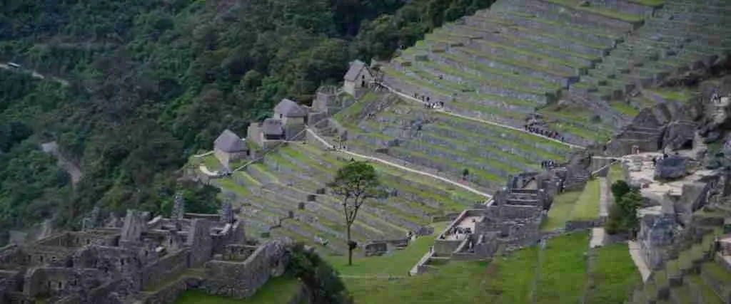
Constructing a 25,000-mile highway through mountains and jungles sounds impossible today—yet Inca engineers achieved it over 500 years ago. Their route adapted to every obstacle, from Andean peaks to Amazonian valleys, using methods that still impress modern builders.
Innovative Construction Techniques
Inca builders worked without iron tools or wheels but mastered earthquake-resistant designs. They cut stones so precisely that mortar wasn’t needed—a technique visible in Peru’s Ollantaytambo walls. For unstable slopes, they layered gravel and clay beneath paving stones to prevent erosion. This explains why parts of the network survive intact across six countries.
The Role of Retaining Walls, Bridges, and Stairways
Steep terrain demanded creative solutions. Retaining walls stabilized roads on cliffs, while grass-rope suspension bridges spanned rivers like the Apurímac. The Q’eswachaka Bridge—rebuilt annually using traditional methods—shows this history in action. Stone staircases, like those near Cusco, turned impossible slopes into manageable paths.
| Feature | Engineering Purpose | Modern Example |
|---|---|---|
| Retaining Walls | Prevent landslides | Sacred Valley trails, Peru |
| Suspension Bridges | Cross deep gorges | Q’eswachaka, Peru |
| Stone Stairways | Navigate steep ascents | Ingapirca complex, Ecuador |
These elements weren’t just functional—they reflected Inca cosmology. Roads often aligned with sacred mountains or solstice paths. Today, countries like Colombia and Chile preserve these parts as open-air museums where route planners blended practicality with spiritual meaning.


Cultural and Spiritual Dimensions
Beyond its engineering feats, the ancient trail network served as a sacred corridor linking humanity to the divine. Pilgrims once traveled these paths to honor mountain deities and participate in ceremonies at shrines perched above 13,000 feet. Today, these routes remain vital to understanding Andean cosmology—where every stone and spring held spiritual meaning.
Religious Practices and High-Altitude Shrines
Inca spirituality thrived at elevations where earth met sky. Sacred sites like Machu Picchu and Ecuador’s Ingapirca complex featured solar temples aligned with solstices. Offerings of coca leaves and chicha beer were left at huacas (shrines) to appease Apus—mountain spirits believed to control weather and harvests.
Modern festivals like Peru’s Inti Raymi still celebrate sun worship along these routes. In Ecuador, communities rebuild the Q’eswachaka Bridge annually using ancient rituals, reinforcing ties to ancestral traditions. These practices highlight why UNESCO designated the network a World Heritage site—it’s a living testament to enduring beliefs.
The Role of Ritual Roads in Inca Beliefs
Paths weren’t just physical routes—they symbolized journeys between worlds. Pilgrims followed trails to sacred peaks like Ausangate, where they’d conduct despacho ceremonies. Roads also connected administrative hubs like Pachacamac, blending governance with spiritual authority.
| Sacred Site | Spiritual Purpose | Location |
|---|---|---|
| Machu Picchu | Royal solar observatory | Peru |
| Ingapirca | Moon temple ceremonies | Ecuador |
| Saqsayhuamán | Inti Raymi festival grounds | Peru |
These sections of the trail reveal how geography shaped faith. In Peru and Ecuador, guides share stories of how ancestors communicated with gods through ritual walks. By preserving these routes, modern travelers glimpse a worldview where nature and divinity were inseparable.
Exploration Routes Along the Qapaq Ñan
The ancient network offers two distinct adventures: windswept coastal trails and sky-high mountain passages. Travelers face a thrilling choice—follow sandy paths hugging the Pacific or conquer stone staircases scaling Andean peaks. Each route reveals unique engineering solutions and cultural treasures.
Coastal Trails: Sun-Kissed Pathways
Stretching over 3,900 kilometers, the coastal ñan connected fishing villages and ceremonial centers. Wide earthen paths—some reaching 20 meters across—allowed llama caravans to transport dried fish and Spondylus shells. Key sites like Pachacamac showcase massive adobe pyramids where pilgrims once worshipped ocean deities.
Mountain Passes: High-Altitude Challenges
Andean routes demand stamina, climbing through cloud forests to 15,000-foot summits. Ingenious bridges made from ichu grass spanned dizzying gorges, while stone-paved trails with gutters prevented washouts. The Huaraz region’s remote passes lead to villages preserving centuries-old textile traditions.
| Feature | Coastal Route | Mountain Route |
|---|---|---|
| Surface | Packed earth | Fitted stone |
| Climate | Arid, warm | Variable, chilly |
| Key Stop | Tambo Inga ruins | Quelccaya Glacier |
Prefer salt-sprayed cliffs or thin-air vistas? Coastal hikes suit photographers capturing desert sunsets. Mountain treks reward with archaeological wonders like Chavín de Huántar. Both routes feature tambos—ancient rest stations spaced every 30 kilometers—now ideal picnic spots.
Choose your challenge: stroll past Paracas’ red-sand beaches or tackle Peru’s Cordillera Blanca. Either way, you’ll walk where empires rose and traditions endure.
Qapaq Ñan in the Inca Empire
The Inca Empire’s sprawling territory demanded unmatched organizational prowess. At its core lay a sophisticated road network that functioned as both political tool and communication lifeline. Stretching from Cusco—the empire’s nerve center—these pathways enabled rulers to govern diverse regions with remarkable efficiency.
The Royal Road’s Role in Administration and Communication
Four main sections of the road system connected administrative hubs across mountain ranges and valleys. Messengers called chasquis sprinted between relay stations, passing quipu-coded messages at a staggering pace. Historical records show a single dispatch could travel 1,200+ miles in five days—faster than colonial horseback riders.
High-altitude routes posed unique challenges. Engineers carved staircases into cliffs and built suspension bridges to maintain connectivity at extreme elevations. These mountain passages ensured officials could inspect terraced farms, collect taxes, and deploy troops swiftly.
| Terrain | Road Width | Key Feature | Administrative Use |
|---|---|---|---|
| Coastal | 6-8 meters | Packed earth | Goods transport |
| High Andes | 1 meter | Stone stairs | Military routes |
| Jungle edge | 2 meters | Raised platforms | Border control |
Strategic communication hubs like Vilcashuamán sat at crossroads, where officials coordinated resource distribution. Tambos (rest stations) stored supplies every 12 miles—a distance calculated for optimal travel speed. This level of planning allowed the empire to manage everything from famine relief to royal decrees.
Today, remnants of these sections reveal how geography shaped governance. Steep trails near Quito show adaptations for rainy seasons, while desert routes prioritized shade. Each path served as a thread binding distant communities to Cusco’s authority.
Transportation, Trade, and Military Strategies
The success of the Inca Empire hinged on a network that moved more than goods—it transported ideas, soldiers, and cultural identity across vast distances. Over centuries, this intricate system became the backbone of imperial control, connecting highland villages to coastal markets and military outposts.
Speed, Commerce, and Cultural Bridges
Chasquis—elite relay runners—could deliver messages 150+ miles daily using stone-paved highways. Llama caravans followed wider routes, hauling dried fish, textiles, and ceremonial coca leaves. Goods like Ecuadorian obsidian reached Peruvian temples, while Bolivian silver adorned nobles in Cusco.
Rest stations called tambos spaced every 12 miles enabled round-the-clock travel. These hubs buzzed with traders swapping regional specialties:
| Region | Exported Goods | Imported Needs |
|---|---|---|
| Coast | Cotton, shellfish | Potatoes, wool |
| Highlands | Quinoa, ceramics | Salt, tropical fruits |
| Amazon | Feathers, medicinal plants | Tools, woven goods |
Fortresses and Strategic Control
Military planners built pukaras—stone fortresses—on cliffs overlooking key routes. Soldiers stationed here monitored traffic and repelled invasions. During the 15th century, these strongholds helped the empire dominate rival cultures like the Chachapoya.
Armies marched swiftly using suspension bridges and mountain staircases. Supplies from nearby warehouses ensured campaigns lasted months. Even during conflicts, shared road use fostered cultural exchanges—Andean weavers adopted motifs from conquered artisans.
By blending trade efficiency with military might, the network sustained imperial power for generations. Its legacy reminds us how infrastructure shapes both economies and identities.
Integrative Influence on Andean Cultures
The vast expanse of interconnected trails served as a cultural bloodstream for Andean civilizations. Stretching over 30,000 kilometers across six countries, this network’s length allowed distant communities to share ideas, traditions, and resources. Its infrastructure—from mountain staircases to coastal pathways—created a shared identity among diverse groups.
Bridges Between Worlds
Robust engineering enabled daily interactions across harsh landscapes. Suspension bridges like Q’eswachaka connected highland weavers to coastal traders, while waystations stored goods for regional exchange. This system transformed isolated villages into linked economic zones.
| Exchange Type | Coastal Example | Highland Example |
|---|---|---|
| Goods | Spondylus shells | Alpaca wool textiles |
| Technology | Fishing net designs | Terrace farming methods |
| Beliefs | Ocean deity rituals | Mountain spirit ceremonies |
The road’s physical reach allowed quinoa from Peru’s Sacred Valley to reach Ecuadorian markets. Artisans in Bolivia adopted pottery styles from northern areas, blending techniques into new creations. Shared infrastructure also spread the khipu recording system—a language of knots managing trade data empire-wide.
By uniting ecological zones through travel corridors, the network fostered resilience. Drought-stricken communities received maize via llama caravans, while coastal groups traded cotton for wool. This interdependence strengthened cultural bonds that endure in festivals and crafts today.
Modern Impacts and Tourism Revival
Once a hidden path, the Inca Trail has blossomed into a global pilgrimage for adventurers. Recognized as a UNESCO World Heritage Site in 2014, this ancient route now attracts over 1.2 million annual visitors. Its revival blends historical legacy with modern exploration, creating jobs and fostering cultural pride.
The Inca Trail to Machu Picchu
Machu Picchu stands at the heart of this resurgence. Over 60% of travelers begin their journey here, where improved facilities like eco-lodges and permit systems balance accessibility with conservation. Local guides lead hikes, sharing ancestral stories while demonstrating traditional textile techniques.
Strategic integration of old and new infrastructure enhances the experience:
- Reconstructed trail sections using original stone-laying methods
- Solar-powered rest stations mirroring ancient tambos
- Interactive apps detailing archaeological sites
Peru’s Kick-Start program trains residents as heritage interpreters—a capital investment preserving traditions. “Walking this road feels like time travel,” notes one hiker. The Inca road now fuels sustainable tourism, proving ancient pathways can thrive in modern times.
| Historical Feature | Modern Adaptation | Impact |
|---|---|---|
| Stone staircases | Reinforced hiking paths | Safer climbs |
| Messenger stations | Wi-Fi enabled checkpoints | Real-time updates |
| Ceremonial sites | Cultural demonstration zones | Deeper engagement |
This integration of past and present turns every step into a dialogue between eras. For travelers, it’s more than a hike—it’s a chance to become stewards of living history while supporting local capital growth.

Preservation Efforts and UNESCO World Heritage Status
In 2014, UNESCO’s recognition of the andean road system as a World Heritage Site ignited global efforts to protect this engineering marvel. Six countries now collaborate to safeguard its 26,000+ kilometers of trails, balancing tourism with cultural preservation. The designation provides funding for restoring ancient stone pathways while empowering local communities as heritage guardians.
Conservation Initiatives and Collaborative Preservation
Peru, Ecuador, and Colombia lead projects using traditional techniques to repair collapsed walls and eroded sections. Teams combine archaeology with modern tools—like 3D mapping—to document fragile road network segments. Key strategies include:
- Training villagers in ancestral masonry methods
- Limiting visitor numbers in sensitive areas
- Installing eco-friendly drainage systems
| Country | Conservation Focus | Key Achievement |
|---|---|---|
| Peru | Machu Picchu access routes | 95% trail stability restored |
| Ecuador | Ingapirca complex | Local-led tourist education |
| Argentina | Desert pathway protection | Erosion reduced by 40% |
Challenges remain. Climate change accelerates stone degradation in high-altitude areas, while illegal mining threatens remote trails. Yet successes like Bolivia’s community patrols—which cut vandalism by 70%—show progress. As UNESCO notes:
“This road network isn’t just history—it’s a bridge between past and future generations.”
Your visit matters. Choosing certified tour operators directly funds preservation. Every step on these ancient stones helps sustain a andean road system that defied empires and still unites nations.
Conclusion
Traversing ancient pathways reveals more than landscapes—it uncovers the heartbeat of a civilization. The Inca road system stands as a testament to human ingenuity, weaving through rugged valleys, scaling mountain walls, and uniting distant territories. Its stone-paved routes and strategic bridges showcase engineering brilliance that harmonized with nature’s contours.
From sacred valleys hosting trade caravans to imposing walls resisting centuries of erosion, every segment tells a story of adaptation. Spanning six modern nations, these routes transformed isolated territories into a cohesive empire. Preservation efforts now protect this heritage, ensuring future generations grasp its historical and cultural weight.
Adventure seekers today walk where messengers once sprinted, surrounded by cloud forests and archaeological wonders. By exploring responsibly, travelers support communities safeguarding ancestral traditions. Ready to trace history’s footsteps? Lace up your boots—the trail awaits those eager to connect past and present.
