Diamond Head Crater Hike: Complete Guide to Oahu’s Iconic Trail
Lēʻahi—known worldwide as Diamond Head—rises 760 feet above Honolulu’s coastline as Oahu’s most recognizable volcanic landmark. This ancient crater trail climbs 0.8 miles through military tunnels and steep staircases to deliver panoramic views spanning from Koko Head to the Waianae Range, making it one of Hawaii’s most rewarding short hikes. The path built in 1908 for coastal defense now welcomes hikers through geological formations created 300,000 years ago, offering an experience that combines natural wonder, military history, and cultural significance in under two hours.
Key Takeaways About the Diamond Head Hike
- Trail Statistics: The hike covers 0.8 miles one-way (1.6 miles round-trip) with 560 feet of elevation gain from the crater floor to the 760-foot summit, featuring paved sections, switchbacks, 170+ stairs across multiple sections, a 225-foot tunnel, and steep military bunker passages.
- Physical Challenge: Moderate difficulty requiring basic fitness, with uneven terrain, narrow tunnels requiring ducking, spiral staircases in historic bunkers, and exposed slopes offering zero shade—the hike takes 30-45 minutes ascending and 60-90 minutes for the complete round-trip experience including summit time.
- Reservation Requirements: Non-resident visitors must book timed entry slots up to 30 days in advance through the Hawaii state parks system, with sunrise time slots selling out within hours of availability and no walk-up entry permitted without confirmed reservations.
- Historical Significance: The trail follows a military route constructed in 1908 as part of Oahu’s coastal defense network, passing through Fire Control Station bunkers completed in 1911, a navigational lighthouse built in 1917, and artillery observation posts that directed defense batteries during both World Wars.
- Cultural Heritage: Known as Lēʻahi in Hawaiian—meaning “brow of the tuna” for its dorsal fin profile—the crater served as a sacred navigational landmark where ancient Hawaiians lit beacon fires to guide ocean voyagers, built heiau temples at the summit, and conducted ceremonial practices for over a thousand years before Western contact.
- Summit Rewards: The 360-degree panorama encompasses Waikiki’s urban coastline, Honolulu’s sprawling metropolitan area, the Pacific Ocean stretching to neighboring islands, Koko Head crater to the east, and the Waianae mountains to the west, with winter months offering potential humpback whale sightings offshore.
People Also Ask About Diamond Head Crater Hike
How Difficult Is the Diamond Head Hike?
Diamond Head rates as a moderate hike accessible to most visitors with basic fitness levels. The trail combines paved concrete walkways, natural tuff surfaces, switchback slopes, two major staircase sections totaling 170+ steps, and a 225-foot tunnel passage. The elevation gain of 560 feet over 0.8 miles creates a steady upward climb without technical sections, though the uneven terrain, narrow bunker passages requiring ducking, spiral staircases inside the Fire Control Station, and complete exposure to sun on the upper slopes demand proper footwear, hydration, and pacing. Visitors report completing the ascent in 30-45 minutes, with slower paces around 50-60 minutes remaining entirely normal. The descent takes 20-30 minutes, bringing total trail time to 60-90 minutes including summit photography and view appreciation.
The specific challenges include steep stairs near the summit where traffic bottlenecks during peak hours, a dark tunnel requiring phones or flashlights for safe passage, claustrophobic moments in narrow military bunker corridors, and relentless sun exposure creating temperatures 10-15 degrees warmer inside the crater compared to Waikiki. Families with young children complete the hike successfully when starting early, carrying sufficient water, and taking frequent breaks. The trail poses difficulties for visitors with knee issues due to stair descent impact, mobility limitations preventing tunnel navigation, or respiratory conditions exacerbated by steep climbing at low elevation in humid tropical air.
What Is the Hawaiian Name for Diamond Head and What Does It Mean?
Lēʻahi is the Hawaiian name for Diamond Head, translating to “brow of the tuna” or “forehead of the tuna.” The name combines “lae” meaning brow, forehead, or promontory with “ahi” meaning yellowfin tuna, describing how the crater’s ridgeline profile resembles the dorsal fin of a large tuna when viewed from the ocean. According to Hawaiian tradition, Hi’iaka—sister of the fire goddess Pele and goddess of hula—first made this observation about the crater’s distinctive shape. The name reflects the practical, descriptive approach ancient Hawaiians applied to geographical features, naming them according to their appearance or characteristics rather than abstract concepts.
An alternative interpretation suggests “ahi” also references fire, connecting to the navigational beacon fires lit at Lēʻahi’s summit by ancient Hawaiians to guide ocean-going canoes traveling along Oahu’s southern coastline. These signal fires served as crucial navigation aids for voyagers approaching from the open Pacific, with a heiau temple built at the summit dedicated to the god of wind, protecting the flames from strong updrafts that could extinguish these vital beacons. The modern English name Diamond Head originated in 1825 when British sailors exploring the crater discovered sparkling calcite crystals embedded in the volcanic tuff and mistakenly believed they had found diamonds. Though the crystals proved worthless, the name persisted, becoming the crater’s internationally recognized designation while Lēʻahi remains the proper Hawaiian identifier still used by local communities and cultural practitioners.
When Is the Best Time to Hike Diamond Head?
Early morning slots between 6:00-8:00 AM provide optimal hiking conditions with cooler temperatures, softer lighting for photography, fewer crowds on the trail and summit, and the possibility of sunrise views if you secure the earliest 6:00 AM reservation window. The crater floor temperatures remain 10-15 degrees warmer than Waikiki throughout the day due to the enclosed bowl shape trapping heat and reflecting sun from tuff walls, making afternoon hikes significantly more challenging. Sunrise hikers reach the summit by 6:45-7:00 AM to witness the sun emerging over the Pacific horizon, casting golden light across Honolulu and illuminating the coastline in dramatic early morning colors that fade within 30 minutes of sunrise.
Mid-morning slots from 8:00-10:00 AM balance accessibility with manageable conditions, avoiding the crush of sunrise crowds while maintaining reasonable temperatures before the midday heat intensifies. Late morning through early afternoon (10:00 AM-2:00 PM) creates harsh overhead lighting reducing photographic appeal, maximum heat exposure approaching uncomfortable levels for sustained physical exertion, and peak visitor volumes creating congestion at narrow trail sections, stairways, and the summit platform. Late afternoon reservations approaching the final 4:00 PM entry time offer cooler temperatures as the crater gains shade, fewer crowds compared to morning peaks, and golden hour lighting for sunset photography, though visitors must complete the hike and exit before the 6:00 PM gate closure with no flexibility for delays.
Do You Need Reservations to Hike Diamond Head?
Advance reservations through the Hawaii state parks online system are mandatory for all non-resident visitors attempting to hike Diamond Head, with no exceptions for walk-up entry regardless of circumstances. The reservation system implemented in May 2022 caps daily visitor numbers to protect the fragile crater ecosystem from erosion damage, reduce vehicle congestion in surrounding neighborhoods, and maintain hiking experiences worth the visit after years of overcrowding created two-hour gate waits and environmental degradation. Hawaii residents with valid state ID or driver’s license enter free without reservations at any time during operating hours, while all other visitors must purchase timed entry slots up to 30 days in advance starting at midnight Hawaii time on the date availability opens.
Popular sunrise and early morning time slots sell out within hours of becoming available, requiring visitors to book exactly 30 days before their desired hiking date to secure preferred times. The reservation confirms a specific entry window—you must pass through the crater entrance gate within the first 30 minutes of your reserved time slot or the reservation becomes void with no refunds, grace periods, or flexibility for late arrivals. Each reservation requires separate entry tickets for every person in your party age 4 and older, with children 3 and under entering free but still requiring inclusion in your reservation count. The system permits modifications and cancellations according to the state parks policy, though last-minute cancellations often prevent other visitors from filling the slot due to the 30-day advance booking window.
Extended multi-day tours – 5+ days
Featured Honolulu Multi-Day Tour Packages

3 days
Honolulu 3-Day Discovery Tour
- ✓ Comprehensive Honolulu experience
- ✓ Expert local guides included
- ✓ All accommodation included
- ✓ Transportation provided

5 days
Honolulu 5-Day Highlights Experience
- ✓ Comprehensive Honolulu experience
- ✓ Expert local guides included
- ✓ All accommodation included
- ✓ Transportation provided

7 days
Honolulu 7-Day Cultural Journey
- ✓ Comprehensive Honolulu experience
- ✓ Expert local guides included
- ✓ All accommodation included
- ✓ Transportation provided

10 days
Honolulu 10-Day Complete Adventure
- ✓ Comprehensive Honolulu experience
- ✓ Expert local guides included
- ✓ All accommodation included
- ✓ Transportation provided
Multi-day tour packages powered by TourRadar. Prices and availability subject to change.
Introduction to Diamond Head State Monument
Diamond Head dominates Honolulu’s southeastern skyline with a profile recognized across countless photographs, films, television shows, and postcards representing Hawaii to the world. This volcanic tuff cone rises as Oahu’s most iconic natural landmark, drawing more than 3,000 daily visitors to a hiking trail that combines geological wonder, military history, and Hawaiian cultural heritage into an experience accessible to most fitness levels. The crater’s formation from a single explosive volcanic event 300,000 years ago created the distinctive saucer-shaped bowl and prominent coastal headland that ancient Hawaiians named Lēʻahi—the brow of the tuna—for its resemblance to a fish’s dorsal fin when viewed from ocean approaches.
The trail ascending to Diamond Head’s 760-foot summit follows paths constructed in 1908 by the United States Army as part of Oahu’s comprehensive coastal defense system, passing through concrete bunkers, observation posts, and tunnels that directed artillery fire protecting Honolulu Harbor and Pearl Harbor from potential naval attacks. These military installations transformed a sacred Hawaiian site where navigational fires once guided ocean voyagers into a strategic fortress monitoring approaches to Hawaii’s critical military and civilian infrastructure through two World Wars and the Cold War era. The trail’s present incarnation as Hawaii’s premier short hiking experience reflects the crater’s transition from active military reservation to protected state monument, balancing preservation of natural and cultural resources with public access to spectacular panoramic views.
The hike delivers extraordinary value for its modest physical demands—0.8 miles of upward walking through fascinating terrain features produces 360-degree vistas encompassing urban Honolulu, Waikiki’s resort corridor, the Pacific Ocean stretching toward neighboring islands, and Oahu’s southeastern coastline from Koko Head past Diamond Head Beach Park to Kahala. The experience requires 60-90 minutes total including ascent, summit time, and descent, making it feasible for visitors with limited schedules to accomplish a signature Hawaii activity without consuming an entire day. The combination of accessibility, dramatic views, historical significance, and proximity to Waikiki resorts explains Diamond Head’s status as one of Hawaii’s most heavily visited destinations, attracting hikers ranging from fitness enthusiasts seeking sunrise workouts to families introducing children to volcanic landscapes and military history.
Understanding Diamond Head’s geological origins, cultural importance to Native Hawaiians, military transformation, and current conservation challenges enriches the hiking experience beyond simple summit-seeking. The trail traverses multiple zones of interest—volcanic tuff formations visible in exposed crater walls, introduced vegetation species planted during the military era, historical fortification structures preserved as educational resources, and native Hawaiian plant species restored through conservation programs. The crater ecosystem exists under constant pressure from visitor impacts including trail erosion, vegetation trampling, and infrastructure stress, making respectful hiking practices and adherence to designated paths essential to preserving this landmark for future generations. The mandatory reservation system represents Hawaii’s commitment to sustainable tourism, limiting daily visitor numbers to levels the fragile volcanic environment can sustain while maintaining the quality of experience that makes Diamond Head worth visiting.
Diamond Head Crater: Geological Formation and Natural History
Diamond Head’s distinctive profile emerged from a single cataclysmic volcanic eruption approximately 300,000 years ago during a period of renewed volcanic activity from the Koʻolau Volcano long after the main mountain range forming Oahu’s eastern spine had become dormant. This eruption belongs to the Honolulu Volcanic Series—a collection of secondary volcanic events that created many of Oahu’s recognizable landmarks including Punchbowl Crater, Hanauma Bay, Koko Head, and Mānana Island. Unlike the slow, effusive lava flows characterizing Hawaiian shield volcanoes, Diamond Head formed through explosive interaction between rising magma and groundwater or seawater, generating massive steam pressure that fragmented molten rock into fine ash and particles blown skyward in a violent, short-duration blast.
The falling ash and volcanic debris settled around the vent in layers that compacted and cemented together through heat, pressure, and chemical reactions into volcanic tuff—the consolidated rock visible throughout the crater walls and trail surfaces. Tuff consists of compressed ash, pumice fragments, and volcanic glass particles fused into a relatively soft, porous stone that erodes more easily than solid basalt lava, explaining the crater’s gradual weathering and the sediment accumulation on the crater floor. The explosion created the characteristic tuff cone shape with steep exterior slopes rising sharply from the surrounding landscape and a broad, saucer-shaped interior crater floor sitting approximately 200 feet below the crater rim. This bowl configuration traps heat and creates the microclimate that makes hiking temperatures 10-15 degrees warmer inside the crater compared to coastal Waikiki just one mile away.
Diamond Head’s volcanic rock contains the calcite crystals that British sailors mistook for diamonds in 1825, giving the crater its English name. These calcite deposits formed as mineral-rich groundwater percolated through the porous tuff, leaving calcium carbonate crystals that sparkle in sunlight along crater slopes and beaches at the base. The crystals possess no commercial value, representing a geological curiosity rather than precious gemstones, though their presence created the name that replaced Lēʻahi in common international usage. The tuff composition also explains the crater’s erosion patterns—softer rock allows water infiltration creating drainage channels, supports vegetation root penetration enabling plant colonization, and permits the carving of military tunnels and bunkers without requiring explosives or sophisticated excavation equipment.
The crater floor ecosystem evolved from the original volcanic landscape through centuries of natural succession and more recent human introduction of non-native species. The semi-arid interior climate supports drought-tolerant shrubs and grasses rather than lush tropical vegetation, with shallow tuff soils limiting large tree growth to areas near the parking lot where deeper soil accumulation occurs. During rainy periods the crater floor transforms into temporary wetlands as the low-permeability tuff prevents rapid water drainage, creating seasonal pools that support specialized plant communities adapted to alternating wet and dry conditions. Most vegetation visible along the trail consists of introduced species brought to Oahu in the late 1800s and early 1900s, particularly koa haole imported as cattle feed that now dominates the crater’s lower slopes with spindly, drought-adapted growth.
Native Hawaiian plant species once thriving in the crater faced near-total elimination during military occupation and intensive use, with recent conservation programs working to restore indigenous vegetation including native grasses, shrubs, and coastal strand plants adapted to volcanic tuff substrates and limited water availability. The crater supports limited wildlife compared to Oahu’s mountain forests, with introduced bird species like zebra doves and common mynas far outnumbering native species. The crater’s geological and ecological significance led to its designation as a National Natural Landmark in 1968, recognizing both the volcanic formation’s scientific value and the need for long-term preservation of this iconic landscape feature visible from throughout southern Oahu.
Military History: From Coastal Defense to State Monument
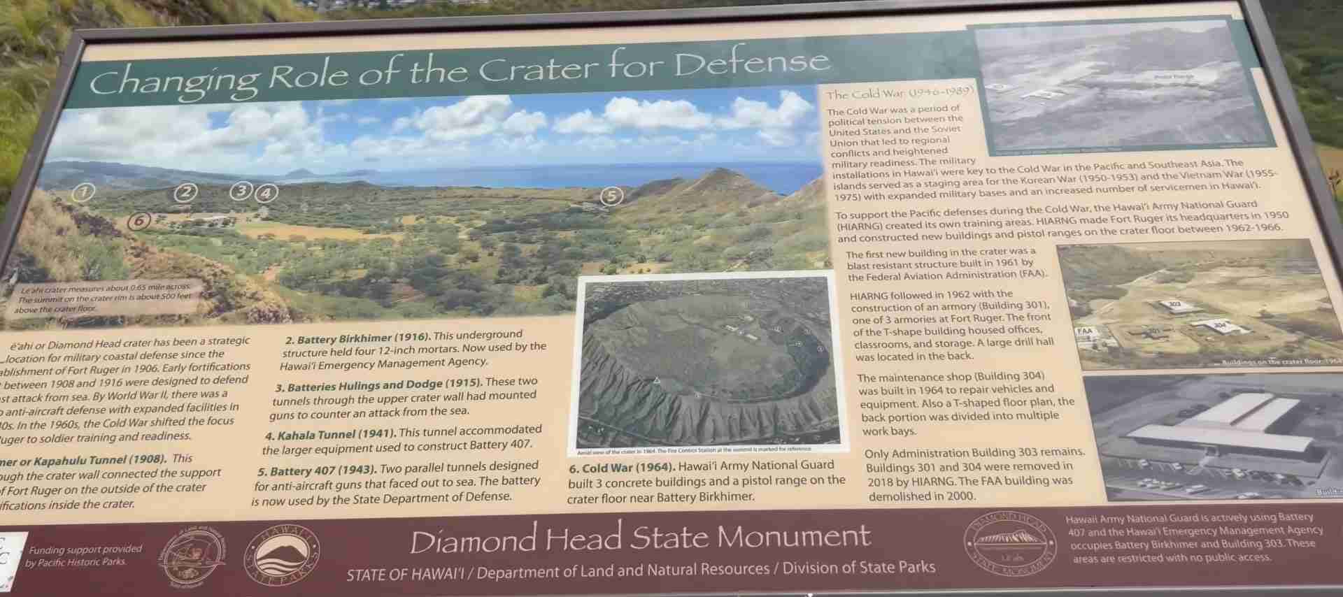
Diamond Head’s strategic position overlooking Honolulu Harbor and commanding views of Oahu’s southern coastline made it an obvious military asset during the early 20th century as the United States fortified Hawaii against potential naval attacks in the Pacific. The United States government purchased the crater in 1904, establishing Fort Ruger as part of a comprehensive coastal defense network protecting Hawaii’s military installations, civilian population, and commercial shipping infrastructure. The crater’s elevated position, natural fortification from thick tuff walls, and concealment potential for artillery batteries and observation posts made it ideal for monitoring ocean approaches and coordinating defensive fire from multiple gun positions scattered across southern Oahu.
Construction of the Diamond Head trail began in 1908, built not as a recreational hiking path but as a military access route allowing soldiers to reach observation posts, communications facilities, and fire control stations positioned at strategic points on the crater rim and summit. The trail’s design reflects military engineering priorities—switchbacks reduce grade steepness for heavy equipment transport, the tunnel provides protected passage through the crater wall safe from enemy fire or observation, and the concrete construction ensures year-round accessibility under all weather conditions for personnel requiring reliable summit access. The paved sections minimized erosion during Hawaii’s heavy rainstorms while creating stable footing for soldiers carrying equipment, ammunition, and supplies to summit installations.
The Fire Control Station completed in 1911 represents the trail’s primary military objective, housing observation equipment, range-finding instruments, communications gear, and plotting tables used to direct artillery fire from coastal batteries positioned in Waikiki and at Fort Ruger outside the crater. This bunker complex carved into the summit tuff allowed observers to track approaching vessels, calculate firing solutions, and transmit targeting data to gun crews who could engage threats beyond direct visual range. The station’s protected location inside the crater rim shielded it from naval bombardment while providing 360-degree observation coverage of ocean approaches from multiple angles. The spiral staircase hikers climb today transported soldiers between different observation levels and communications rooms, creating the steep, narrow passage that forms one of the trail’s most challenging sections.
The navigational lighthouse constructed at the summit in 1917 served both military and civilian purposes, warning ships of Diamond Head’s reef hazards while providing a navigation reference point for vessels approaching Honolulu Harbor at night or in poor visibility conditions. The lighthouse continues operating today under Federal Aviation Administration control, with the distinctive white structure visible from throughout Waikiki and southern Oahu marking Diamond Head’s precise summit location. Additional fortifications built during the World Wars included observation bunkers, communications installations, ammunition storage facilities, and personnel shelters, though most of these structures remain closed to public access due to safety concerns or ongoing military use by Hawaii National Guard units maintaining emergency operations facilities inside the crater.
Fort Ruger’s military significance peaked during World War II when Diamond Head served as a critical observation post monitoring for Japanese naval or air attacks approaching Oahu. The December 7, 1941 Pearl Harbor attack demonstrated the vulnerability of Hawaii’s military installations to carrier-launched aircraft, though the coastal defense batteries Diamond Head observation posts controlled remained operational throughout the war as protection against potential naval bombardment or invasion attempts. Post-war military drawdown gradually reduced Diamond Head’s active defense role as changing warfare technology made coastal artillery obsolete, replaced by air defense systems, naval air power, and missile installations requiring different strategic positioning.
The State of Hawaii acquired Diamond Head in 1962 through transfer from federal military control, though certain facilities including Battery 407 and the Birkhimer Tunnel civil defense headquarters remain under Department of Defense and Hawaii National Guard control for emergency operations purposes. The 1968 National Natural Landmark designation recognized the crater’s geological and ecological significance while state park status opened the summit trail to civilian hiking access, transforming a century of military exclusivity into public recreation and education opportunities. The preservation of military structures along the trail creates a living history museum where visitors experience authentic fortifications while learning about coastal defense strategies, observation techniques, and the soldiers who manned these installations through two World Wars and the Cold War era protecting Hawaii from threats that never materialized into actual attacks on the crater positions.
Trail Overview and Specifications
The Diamond Head summit trail measures 0.8 miles one-way from the trailhead parking area on the crater floor to the highest observation point at 760 feet above sea level, creating a 1.6-mile round-trip hike with 560 feet of total elevation gain. The trail gains elevation at an average grade of approximately 13-14 percent, though this figure understates the difficulty since the route includes level walking sections on the crater floor and concentrated steepness on switchbacks and staircases where grades exceed 25-30 percent. The physical challenge comes less from total distance or elevation—both modest by hiking standards—than from the sustained upward climbing, multiple long staircase sections totaling 170+ steps, tunnel navigation, and complete sun exposure creating heat stress that exceeds the trail’s technical difficulty.
The route begins as a wide, concrete walkway suitable for wheelchairs and strollers through the initial 0.2 miles across the crater floor, passing through sparse koa haole forest that provides the trail’s only significant shade. This concrete section enables accessibility for visitors unable to complete the full summit hike, offering views of the crater interior, volcanic tuff formations, and the surrounding rim from the base. After 0.2 miles the surface transitions to natural tuff—a compacted volcanic ash surface that becomes uneven, rocky, and increasingly steep as the route enters the switchback section climbing the interior crater wall. The switchbacks zigzag up the slope in a series of long traverses connected by short, steep turns that maintain a manageable grade while gaining elevation efficiently.
The first major staircase section appears midway up the switchbacks, consisting of approximately 75 steps climbing a particularly steep section where switchbacks become impractical due to space constraints. These stairs create the first significant bottleneck during busy periods as uphill and downhill traffic negotiates the single-file passage, with informal yielding protocols generally favoring uphill hikers maintaining momentum over descending hikers who can pause more easily. The stairs lead to the entrance of the 225-foot tunnel carved through the crater wall, creating the trail’s most unusual feature—a dark, cool passage requiring phones, flashlights, or headlamps for safe navigation. The tunnel ceiling height varies from comfortable standing clearance to sections requiring tall visitors to duck slightly, with the darkness, confined space, and cool, damp air creating a claustrophobic experience for some hikers.
Emerging from the tunnel deposits hikers at the base of the Fire Control Station bunker, where the route splits into two options reaching the same ultimate destination. The left route follows a more gradual staircase winding up the exterior bunker walls, totaling approximately 95 steps to reach the summit observation platform with views predominantly facing southeast toward Hawaii Kai and Koko Head. The right route enters the bunker interior, climbing a steep spiral staircase of approximately 100 steps through the historical Fire Control Station structure before emerging at a different section of the summit platform facing southwest toward Waikiki and Honolulu. Most hikers choose the left exterior route ascending and the right bunker route descending to experience both passages and avoid retracing steps, though the spiral staircase’s steepness, narrow width, and dim lighting create challenges for visitors with knee problems, claustrophobia, or balance concerns.
The summit area consists of multiple concrete observation platforms built into the crater rim, connected by short level walkways allowing movement between different viewpoint angles without additional climbing. The highest accessible point sits at 760 feet above sea level, though the actual crater rim extends slightly higher in sections closed to public access for safety or conservation purposes. The platforms provide secure footing with chest-high walls preventing falls, accommodating 30-40 visitors comfortably though peak period crowds can exceed 100 people creating congestion that reduces photography opportunities and limits time at individual viewpoints. No facilities exist at the summit—no restrooms, water, seating, or shade—with visitors typically spending 10-20 minutes photographing views and recovering from the ascent before beginning the descent.
The descent follows the same route in reverse, taking 20-30 minutes compared to the 30-45 minute ascent as gravity assistance and familiarity with terrain features increase speed. Descending the staircases demands more knee stress and careful foot placement than ascending, with the potential for slips or trips increasing on the downward journey as fatigue accumulates and attention wanders. Hikers should reserve water and energy for the descent rather than consuming all resources at the summit, as dehydration-related incidents and minor injuries occur more frequently during the downward journey when the finish line visible at the crater floor parking lot creates overconfidence and reduced caution. The total experience from entering the crater gate to exiting back through the parking area typically spans 60-90 minutes including driving or walking to the trailhead, using facilities, hiking both directions, summit time, and the return to vehicles or rideshare pickup points.
Reservation System and Entrance Requirements
The mandatory advance reservation system for Diamond Head launched in May 2022 after years of overcrowding created environmental damage, vehicle congestion, illegal parking in residential neighborhoods, and degraded visitor experiences with two-hour waits at the entrance gate during peak periods. The Hawaii Department of Land and Natural Resources implements the system through the Go Wild Hawaii online platform, requiring all non-resident visitors to book specific time slots up to 30 days in advance of their intended hiking date. The 30-day advance booking window opens at midnight Hawaii Standard Time, meaning popular sunrise slots for June 15 become available for booking at midnight HST on May 16. Visitors must access the booking system precisely at midnight to secure the earliest, most desirable time slots as these sell out within hours of becoming available.
Entry fees cost $5 per person for non-residents age 4 and older (check the official state parks website for current rates, as pricing may vary), with children 3 and under entering free but still requiring inclusion in the reservation count. Parking reservations inside the crater cost an additional $10 per vehicle, creating total costs of $15 for a solo driver or $20 for two people sharing a vehicle. The reservation confirms a specific entry time window—for example, a 7:00 AM reservation permits entry between 7:00-7:30 AM, with strict enforcement of the 30-minute entry window and no grace period for late arrivals. Visitors arriving outside their confirmed window face denied entry with no refunds issued regardless of circumstances including traffic, navigation errors, or other delays beyond the hiker’s control.
Hawaii residents with valid Hawaii state ID or driver’s license enter free without reservations at any time during operating hours, presenting identification at the entrance gate for verification before receiving immediate access. This exemption recognizes Diamond Head’s importance to local communities as a recreational resource and fitness training location, ensuring residents maintain unrestricted access to public lands despite the reservation requirements imposed on visitors. The two-tier system creates occasional confusion when mixed groups include both residents and non-residents, requiring the non-residents to hold valid reservations while residents can arrive without advance booking. Residents should carry ID even when hiking with non-resident friends who hold reservations, as gate staff may request verification of resident status to confirm free entry eligibility.
The reservation booking process requires creating a Go Wild Hawaii account with email verification, selecting the desired date and time slot from available options, adding the correct number of people to the reservation, and completing payment through credit card processing. The system generates a confirmation email containing a QR code that serves as the entry ticket, requiring hikers to display the code on phones or printed paper at the entrance gate for scanning. Visitors should screenshot the QR code or download the confirmation email for offline access in case cellular signal proves unreliable at the crater entrance, as gate staff cannot permit entry without the scannable code regardless of verbal explanations or payment receipts. Each person in a party requires separate entry ticket purchase, though a single reservation can include multiple people with one QR code covering the entire group as long as everyone enters together.
Parking reservations inside the crater become necessary only for visitors arriving by private vehicle, rental car, or hired driver intending to park in the crater lot for the hike duration. Walk-in visitors arriving by bus, rideshare dropoff, bicycle, or foot need only entry tickets without parking reservations, saving $10 per person or group. The crater parking lot capacity limits the number of vehicle reservations available, often selling out before entry-only slots fill completely. Visitors unable to secure parking reservations can book entry-only tickets and arrange rideshare dropoff at the crater tunnel entrance, where Uber and Lyft drivers pick up and drop off continuously throughout operating hours. This workaround proves cheaper than parking for solo hikers while avoiding the parking availability constraint that blocks some visitors from obtaining any reservation at all when vehicle slots sell out but walk-in slots remain available.
Cancellations and modifications follow the state parks system policies, with refunds typically available for cancellations made sufficiently in advance of the reserved date though last-minute cancellations may incur penalties or forfeit fees entirely. The 30-day advance booking window means cancelled reservations often cannot be filled by other visitors since the cancellation occurs after the booking window has closed for that date, creating lost capacity when hikers cancel without adequate notice. No-shows—visitors who book reservations but never arrive—waste public resources and deny access to other visitors who could have used those slots, prompting periodic discussions about implementing penalties for habitual no-show patterns though enforcement remains challenging under current system limitations.
Getting to Diamond Head: Transportation and Parking
Diamond Head sits approximately 3 miles east of central Waikiki along Diamond Head Road, creating a short, straightforward drive from most Honolulu hotels and vacation rentals. Private vehicles and rental cars follow Kalakaua Avenue east through Waikiki, continuing past Kapiolani Park as the road curves around Diamond Head’s exterior slope and becomes Diamond Head Road. After 1.5 miles the entrance tunnel appears on the left side approaching from Waikiki, marked by state monument signage and typically featuring a line of vehicles waiting for reservation verification at the gate. The tunnel passes through Diamond Head’s south rim, emerging onto the crater floor where the parking lot sits adjacent to the trailhead. Driving time from central Waikiki ranges from 8-12 minutes under normal traffic conditions, though morning rush hour and weekend periods can extend travel time to 15-20 minutes.
Parking inside the crater provides maximum convenience for hikers with vehicles, depositing them directly at the trailhead with restroom facilities and the visitor center immediately accessible. The crater lot capacity limits daily parking reservations to levels matching physical spaces available, creating situations where parking slots sell out while walk-in entry reservations remain available. Visitors should book parking reservations simultaneously with entry tickets to ensure vehicle access, recognizing that the $10 parking fee per vehicle adds to the $5 per-person entry cost. The lot fills completely during peak morning hours even with the reservation system, as every reserved slot gets claimed by hikers arriving throughout their entry windows. No overflow parking exists inside the crater, with late arrivals or visitors without parking reservations unable to enter by vehicle regardless of having valid entry tickets.
TheBus public transportation system serves Diamond Head through route 23 from Waikiki, providing an affordable alternative to driving that avoids parking costs and reservation constraints entirely. The bus departs from multiple stops along Kalakaua Avenue in Waikiki at approximately 20-30 minute intervals throughout the day, following a route past Kapiolani Park, around Diamond Head’s exterior, and stopping directly at the monument entrance tunnel. The fare costs $3 per ride, creating a $6 round-trip expense far cheaper than the $10 parking fee for visitors who purchase only entry tickets without vehicle reservations. Bus travel time from Waikiki ranges from 15-25 minutes depending on traffic and the specific pickup point, requiring hikers to build in extra time compared to driving to ensure arrival within their reserved entry window.
Rideshare services including Uber and Lyft provide door-to-door transportation from anywhere on Oahu to the Diamond Head crater entrance, with drivers familiar with the dropoff and pickup procedures at the tunnel entrance outside the crater. Fares from Waikiki hotels range from $8-15 depending on time of day, traffic conditions, and surge pricing during peak demand periods, creating costs comparable to public bus service for solo travelers and cheaper than parking fees for groups of two or more sharing one vehicle. Rideshare dropoff occurs at the tunnel entrance where gate staff verify reservations before allowing walk-in entry without vehicles, eliminating parking concerns entirely while providing flexibility for early morning sunrise hikes when bus service may not align with reservation times. Return pickups request easily through the rideshare apps after completing the hike, with pickup occurring at the same tunnel entrance location where drivers wait in designated areas.
Bicycles and scooters offer another car-free option for fit visitors comfortable riding Honolulu’s streets, though the route from Waikiki to Diamond Head includes moderate hills and heavy vehicle traffic requiring confidence in urban cycling conditions. Bike lanes exist along portions of the route but not the entire distance, with the final approach along Diamond Head Road featuring narrow shoulders and limited separation from fast-moving vehicles. Cyclists can bring bikes into the crater and secure them at the parking lot while hiking, though no formal bike racks exist so improvised locking to fences or signs becomes necessary. The return ride to Waikiki benefits from downhill assistance making the journey faster and less strenuous than the outbound trip.
Walking from Waikiki to Diamond Head proves feasible for determined hikers willing to extend their total walking distance significantly beyond the 1.6-mile trail itself. The 3-mile walk from central Waikiki to the crater entrance along sidewalks paralleling Diamond Head Road takes 50-70 minutes at moderate pace, creating a 6-mile round-trip total plus the 1.6-mile crater hike for an 8-mile walking day. This option suits fitness-focused visitors seeking maximum exercise rather than casual hikers interested primarily in summit views, as the extended road walking offers minimal scenic value compared to actual trail hiking. The route passes Kapiolani Park, Diamond Head Beach Park, and residential neighborhoods with occasional ocean views but primarily consists of urban walking along busy roads.
Trail Description: What to Expect from Start to Summit
The hike begins at the crater floor parking lot adjacent to restrooms, the visitor center, and interpretive displays explaining Diamond Head’s geological formation, military history, and Hawaiian cultural significance. The trailhead kiosk displays route information, safety warnings, and current weather conditions, with water bottle filling stations allowing last-minute hydration before starting the ascent. The initial section follows a wide concrete walkway suitable for wheelchairs and strollers, providing gentle terrain across the crater floor through sparse koa haole forest that offers the only substantial shade hikers encounter on the entire route. This flat 0.2-mile approach section allows families with young children to experience Diamond Head’s crater environment without committing to the strenuous summit climb, with turnaround options available at any point along the concrete pathway.
The concrete transitions to compacted tuff surface as the route begins ascending the crater’s interior wall through a series of long switchbacks that zigzag up the slope in sweeping traverses. The tuff surface provides good traction in dry conditions but can become slippery when wet from rain or morning dew, requiring careful foot placement and awareness of changing friction. The grade increases noticeably compared to the crater floor approach, with upward slopes of 10-15 percent creating sustained climbing that elevates heart rates and breathing for hikers unaccustomed to inclined walking. The switchbacks reveal views back across the crater floor, showing the parking lot, visitor facilities, and the access tunnel diminishing in size as elevation increases.
Vegetation along the switchback section consists primarily of drought-adapted shrubs, grasses, and scattered koa haole trees that provide virtually no shade coverage, exposing hikers to direct tropical sun throughout the middle portions of the climb. The volcanic tuff exposed in crater wall cutbanks displays the layered ash deposits that formed during the explosive eruption 300,000 years ago, with color variations from buff to rust to gray indicating different chemical compositions and weathering conditions. Bird sounds from introduced species like zebra doves and common mynas provide occasional audio interest, though the trail environment supports limited wildlife diversity compared to Oahu’s forested mountains.
The first major staircase appears approximately 0.4 miles from the trailhead, marked by a sudden transition from gradual switchback walking to steep, uneven steps carved into the tuff and reinforced with concrete. These stairs number approximately 75 steps climbing a section too steep for switchback construction, creating the trail’s first significant physical challenge as leg muscles burn and breathing deepens. The stairs narrow to single-file width, forcing uphill and downhill traffic to negotiate passing situations where informal trail etiquette generally grants priority to ascending hikers maintaining momentum over descending hikers who can pause more easily. During peak visitation hours these stairs create bottlenecks with waits of 2-5 minutes as groups bunch together, though midday and late afternoon periods see lighter traffic flowing smoothly.
The staircase deposits hikers at the entrance to the 225-foot tunnel carved through the crater wall during the 1908 trail construction. The tunnel appears as a dark opening in the tuff face, with the interior completely black requiring artificial light sources for safe navigation. Most hikers use phone flashlights or dedicated headlamps to illuminate the passage, revealing rough tuff walls, an uneven floor with occasional puddles, and a ceiling height varying from comfortable clearance to sections requiring tall individuals to duck slightly. The temperature drops noticeably inside the tunnel compared to the sun-baked exterior slopes, creating welcome relief from heat stress though the cool, damp air can feel clammy after sweating profusely on the exposed switchbacks.
The tunnel experience lasts approximately 90 seconds to 2 minutes walking at normal pace, with the darkness, confined space, and unfamiliarity creating mild claustrophobia for some visitors. Children generally find the tunnel exciting rather than frightening, treating it as an adventure element adding novelty to what might otherwise feel like repetitive upward walking. The tunnel serves functional purposes beyond the historical military access role—it provides protected passage through the crater wall safe from falling rocks, reduces total trail distance compared to exterior switchbacks around the rim, and creates a temperature-controlled segment allowing heat recovery before the final summit push.
Emerging from the tunnel places hikers at the base of the Fire Control Station bunker complex, where the route splits into two options reaching identical summit destinations through different passages. The left fork follows exterior stairs winding up the outside of the bunker structure in a series of switchbacks and straight runs totaling approximately 95 steps to reach the southeast-facing observation platform. This route remains outdoors with views opening up as elevation increases, showing the crater interior below, Koko Head crater in the distance, and the southeastern Oahu coastline stretching toward Makapu’u Point. The grade remains steep throughout with sustained climbing rather than level recovery sections, testing leg endurance and cardiovascular fitness as the summit approaches.
The right fork enters the bunker interior, accessing the spiral staircase that originally allowed military personnel to move between different levels of the Fire Control Station during operational periods. This staircase consists of approximately 100 narrow concrete steps winding upward in a tight helix inside the bunker structure, creating the trail’s most challenging passage for visitors with knee problems, balance concerns, or claustrophobia. The dim lighting, narrow width preventing passing, and steep grade combine to make this section feel more difficult than the actual physical challenge justifies, though the historical atmosphere of climbing through authentic military infrastructure adds interest beyond simple summit-seeking. The spiral staircase emerges at the southwest-facing observation platform with views toward Waikiki, Honolulu, and the Waianae Range.
Most hikers choose the left exterior route ascending and the right bunker spiral staircase descending to experience both passages without retracing steps, though personal preferences for outdoor exposure versus enclosed climbing and concerns about knee stress on spiral descents create variations in route selection. The two summit platforms connect via short level walkways allowing movement between viewpoint angles, creating a circuit option that maximizes scenic variety without additional elevation gain. The summit area provides secure footing on concrete platforms with chest-high walls preventing accidental falls, accommodating crowds of 30-40 visitors comfortably though peak periods can see 80-100 people creating congestion that limits photography angles and reduces available space for resting.
The descent follows the same route in reverse, with gravity assistance increasing speed compared to the ascent though demanding more knee control and careful foot placement to prevent slips or trips on uneven surfaces. The tunnel passage occurs midway through the descent, providing a shaded, cool recovery segment before the final switchback section back to the crater floor. The downward staircase sections create impact stress on knees and ankles greater than ascending generated, with hikers often feeling leg fatigue and muscle soreness by the time they reach the crater floor parking lot after the 20-30 minute descent. The concrete walkway final segment provides easy, level walking allowing muscles to relax and heart rate to normalize before reaching vehicles or arranging rideshare pickups.
Physical Requirements and Difficulty Assessment
Diamond Head rates as a moderate difficulty hike accessible to most visitors with basic cardiovascular fitness, functioning knees and ankles, and absence of severe mobility limitations that would prevent stair climbing or uneven terrain navigation. The trail’s 560 feet of elevation gain over 0.8 miles creates an average grade of approximately 13-14 percent, though this overall figure masks significant variation between the gentle crater floor approach, moderate switchback sections, and steep staircase passages exceeding 25-30 percent grade. The physical challenge comes less from technical difficulty—the route requires no scrambling, rock climbing, or balance-challenging narrow passages—than from sustained upward effort in tropical heat and humidity that taxes cardiovascular systems and leg muscles unaccustomed to inclined walking.
Healthy adults in average physical condition complete the ascent in 30-45 minutes moving at a comfortable, sustainable pace with occasional brief pauses for water, photographs, and recovery breathing. Faster hikers with strong cardiovascular fitness reach the summit in 20-25 minutes treating the route as a workout, while slower-paced visitors taking frequent rest breaks and photography stops may require 50-60 minutes ascending without any fitness deficiency or cause for concern. The wide time range reflects variation in age, fitness levels, heat tolerance, and hiking experience rather than misjudgment of the trail’s actual difficulty. Visitors should set personal paces based on comfortable breathing and ability to maintain conversation, avoiding the competitive impulse to match faster hikers’ speeds that can lead to exhaustion or heat stress.
Children as young as 6-7 years complete the hike successfully when properly prepared with water, snacks, sun protection, and realistic expectations about the physical challenge. The trail’s moderate length and clearly defined destination visible from the crater floor help maintain children’s motivation compared to longer hikes where the endpoint remains distant and abstract. The tunnel passage and spiral staircase create adventure elements that children find exciting rather than daunting, adding novelty to what might otherwise feel like tedious upward walking. Parents should pace family groups according to the slowest member’s capabilities, taking breaks as needed and avoiding early morning or midday slots when heat stress adds difficulty beyond the trail’s inherent physical demands. Children under 4-5 years lack the endurance and attention span for the complete hike even carried in backpack carriers, as the 30-45 minute ascent plus summit time and 20-30 minute descent creates a 90-minute commitment that exceeds very young children’s tolerance.
Seniors in good health complete Diamond Head regularly, with proper pacing, adequate hydration, and realistic fitness assessment determining success more than chronological age. The staircase sections demand functional knees capable of sustained climbing and descent without pain or instability, with the descent generating greater knee stress than ascending due to impact forces from downward steps. Seniors with knee replacements, arthritis, or other joint conditions should consult physicians about appropriate activity levels before attempting the hike, recognizing that some visitors find the descent more problematic than the ascent despite the cardiovascular relief from downward walking. Trekking poles provide stability assistance for seniors concerned about balance on uneven surfaces, though the narrow tunnel and spiral staircase create tight quarters where poles become cumbersome to manage.
Pregnant visitors successfully hike Diamond Head throughout pregnancy when cleared by physicians and maintaining appropriate physical activity levels, though the heat exposure, elevation gain, and stair climbing create considerations beyond typical exercise. The trail provides no emergency medical facilities, shaded rest areas, or quick exit routes once committed to the ascent, requiring pregnant hikers to honestly assess their heat tolerance, energy levels, and confidence in completing the full route before starting. First trimester nausea and fatigue, late third trimester balance changes and reduced cardiovascular capacity, and any pregnancy complications creating exercise restrictions warrant conservative decisions about attempting the hike. Pregnant visitors should choose early morning time slots when temperatures remain coolest, carry extra water beyond normal requirements, and feel no embarrassment about turning around if conditions feel unsafe or uncomfortable regardless of proximity to the summit.
Visitors with disabilities face significant challenges on Diamond Head’s summit trail despite the accessible concrete walkway covering the initial crater floor section. The staircase sections totaling 170+ steps, narrow tunnel requiring ducking, spiral staircase inside the bunker, and uneven tuff surfaces create barriers preventing wheelchair users, visitors with mobility aids beyond trekking poles, and individuals with balance disorders or visual impairments from safely accessing the summit. The crater floor accessible section provides wheelchair users experience of Diamond Head’s interior environment including volcanic tuff formations, crater wall views, and historical interpretation, though the summit vistas remain inaccessible without ability to navigate stairs and rough terrain independently. Service animals are permitted on the trail for visitors with documented disabilities requiring assistance, though pets receive strict prohibition due to environmental protection concerns and the challenging terrain unsuitable for dogs.
Heat stress represents the primary safety concern beyond simple physical fitness, with the exposed trail and 10-15 degree temperature increase inside the crater compared to coastal Waikiki creating conditions that challenge visitors accustomed to air-conditioned hotels and rental vehicles. Heat exhaustion symptoms include excessive sweating, weakness, nausea, headache, and dizziness, requiring immediate descent to cooler environments and rehydration before symptoms progress to dangerous heat stroke. Visitors should honestly assess heat tolerance based on personal experience with tropical conditions, choosing early morning hikes before maximum daily temperatures develop and avoiding midday slots when sun exposure becomes intense. One liter of water per person represents the minimum recommendation for the 90-minute total experience, with two liters per person more appropriate for midday hikes, visitors unaccustomed to Hawaii’s heat, or anyone concerned about dehydration risk.
Summit Views and Photography Opportunities
The 360-degree panorama from Diamond Head’s summit observation platforms delivers views spanning the full spectrum of Oahu’s southern landscape from urban Honolulu to natural coastal formations to distant neighboring islands visible on clear days. The most iconic vista faces southwest toward Waikiki, where the resort corridor’s high-rise hotels line the beach in a dense urban wall contrasting with the Pacific Ocean’s blue expanse beyond. This perspective captures the classic Diamond Head postcard view in reverse—instead of seeing Diamond Head from Waikiki, hikers see Waikiki from Diamond Head, revealing how the resort district occupies a narrow strip between the ocean and volcanic slopes. The view extends beyond Waikiki to downtown Honolulu’s financial district, Honolulu Harbor facilities, and the Waianae Range mountains forming the western spine of Oahu approximately 30 miles distant.
The southeast view toward Hawaii Kai and Koko Head showcases Oahu’s dramatic volcanic coastline where the Koʻolau Range meets the Pacific in a series of bays, headlands, and offshore islands. Koko Head crater dominates the eastern horizon as Diamond Head’s larger cousin, rising 642 feet above sea level with its own challenging summit trail visible as a thin line ascending the crater’s exterior flank. The coastline between Diamond Head and Koko Head includes Hanauma Bay—a flooded volcanic crater creating Oahu’s premier snorkeling destination—visible as a distinctive curved indentation in the shoreline with its protected turquoise waters contrasting against deep blue ocean beyond the reef. On exceptionally clear days the islands of Molokai and Lanai appear on the horizon beyond Koko Head, though humidity and haze frequently limit visibility to 15-20 miles preventing reliable distant island views.
The interior crater floor view from the summit platforms reveals Diamond Head’s bowl-shaped structure with the parking lot, visitor facilities, and access tunnel visible as miniature elements far below. This perspective shows the crater’s geological formation clearly—the steep interior walls created by ash accumulation during the explosive eruption, the flat crater floor developed through sediment deposition and erosion over 300,000 years, and the rim crest extending around the crater’s full perimeter with elevation variations creating higher and lower sections. The vegetation pattern shows the transition from introduced koa haole forest near the parking area to drought-adapted scrub on the exposed slopes, illustrating how microclimatic differences control plant distribution even within the confined crater environment.
The north and northwest views encompass Honolulu’s urban sprawl extending from the coast inland toward the Koʻolau Range foothills, showing residential neighborhoods, commercial districts, and the green corridor of Ala Moana Beach Park stretching along the waterfront. The Honolulu cityscape from Diamond Head’s elevation reveals the metropolitan area’s extent far beyond the tourist-focused Waikiki district, with suburban development spreading up valley floors and across the coastal plain in patterns constrained by topography and military reservations. Pearl Harbor appears in the far northwest on clear days, visible as a distinctive harbor indentation and the location of U.S. military installations still active decades after World War II made Hawaii a strategic Pacific headquarters.
Winter months from November through March offer potential humpback whale sightings in the channels between Oahu and neighboring islands as these massive marine mammals migrate from Alaska to Hawaiian waters for breeding and calving. Whale spouts appear as white vapor plumes erupting from the ocean surface at irregular intervals, with patient observers spotting breaches when whales launch their full bodies skyward in spectacular aerial displays visible for miles given the summit’s elevated perspective. Whale watching from Diamond Head lacks the close-range detail of boat-based tours but provides a unique aerial viewing angle showing whale distribution patterns and movement corridors through offshore waters. Binoculars enhance whale watching success and allow detailed observation of coastal features, offshore islands, and distant mountain ranges beyond naked eye resolution.
Photography opportunities vary dramatically by time of day, weather conditions, and sun position relative to viewing directions. Sunrise hikes capture golden light illuminating Honolulu and the ocean while the crater interior remains in shadow, creating dramatic contrast between light and dark landscape zones. The sun rises over the ocean to the east, backlighting Koko Head and the southeastern coastline while front-lighting Waikiki and Honolulu to the southwest for warm, glowing cityscape shots. Morning light remains optimal through approximately 9:00-10:00 AM before overhead sun creates harsh shadows and washed-out colors that reduce photographic appeal. Midday photography from 11:00 AM-2:00 PM suffers from overhead sun positioning that eliminates the directional lighting creating depth and visual interest, though the intense light produces saturated blue ocean colors that some photographers prefer.
Late afternoon and sunset photography benefits from golden hour light illuminating the landscape from low angles, creating long shadows that emphasize topographic relief and warm color tones across urban and natural features. The sun sets in the west beyond the Waianae Range, backlighting those mountains while front-lighting Diamond Head’s crater interior for photographs showing the bowl structure in warm afternoon glow. Sunset hikers must remember the mandatory 6:00 PM exit requirement, calculating summit arrival times to allow adequate photography while leaving sufficient time for the 20-30 minute descent before gate closure. Late afternoon slots approaching the 4:00 PM final reservation time provide access to golden hour lighting but require accepting shorter summit stays and rushed photography to exit before the locked gates trap visitors inside the crater after hours.
Haze and humidity affect visibility and photographic clarity significantly, with typical tropical conditions limiting maximum visibility to 15-20 miles and creating a milky blue-gray haze that obscures distant mountains and islands. Clear, crisp visibility days occur most frequently following strong trade wind periods when consistent airflow from the northeast flushes away atmospheric moisture and pollutants, typically producing the sharpest horizon views and most vibrant blue skies. Rain showers preceding or following the hike can leave residual clouds and mist creating moody, atmospheric conditions different from the standard sunny tropical photography aesthetic but offering unique light quality and dramatic cloudscapes. Photographers should adapt to available conditions rather than chasing idealized scenarios that may not materialize, finding creative opportunities in fog-shrouded cityscapes, storm light illuminating portions of the view while shadows obscure others, and the constantly changing interplay between clouds, sun, and landscape.
Best Times to Hike: Seasonal and Daily Considerations
Early morning reservations between 6:00-8:00 AM provide optimal hiking conditions combining cooler temperatures before the tropical sun reaches maximum intensity, softer directional lighting for photography as the sun rises from the east, reduced crowd density on trails and summit platforms compared to midday peaks, and the psychological satisfaction of completing an achievement before most visitors begin their day. The earliest 6:00 AM reservation slot allows hikers to reach the summit by 6:45-7:00 AM during sunrise periods when the sun emerges over the Pacific horizon casting golden light across Honolulu. Sunrise timing varies throughout the year from approximately 5:50 AM in June to 7:10 AM in January, with hikers needing to research specific sunrise times for their visit dates to determine whether the 6:00 AM entry window permits summit arrival before or after the sun clears the horizon.
The crater interior temperature remains 10-15 degrees warmer than coastal Waikiki throughout the day due to the bowl shape trapping heat and volcanic tuff walls reflecting solar radiation, making early morning starts essential for heat-sensitive visitors who struggle with midday tropical temperatures approaching 85-90 degrees Fahrenheit. The temperature differential between crater floor and summit remains minimal despite the 560-foot elevation gain, as the low altitude change produces negligible cooling effect compared to high-altitude mountain hiking. Morning temperatures in the 70-75 degree Fahrenheit range create comfortable hiking conditions that allow sustainable physical exertion without excessive heat stress, though Hawaii’s high humidity creates perceived temperatures higher than thermometer readings as sweat evaporation slows in moisture-saturated air.
Mid-morning time slots from 8:00-10:00 AM balance accessibility with manageable conditions, avoiding the competitive rush for earliest sunrise reservations while maintaining reasonable temperatures before the midday heat peak. Trade wind breezes from the northeast strengthen during mid-morning hours, providing natural cooling on exposed summit platforms that offsets rising temperatures. The lighting transitions from golden morning glow to harsher overhead sun during this period, reducing photographic appeal compared to sunrise but still offering acceptable conditions for vacation photography emphasizing documentary value over artistic quality. Trail and summit crowds increase throughout the morning as the reservation system delivers steady streams of hikers across multiple time slots, with 9:00-10:00 AM entries facing greater congestion than 6:00-7:00 AM slots but less density than midday peaks.
Late morning and midday reservations from 10:00 AM-2:00 PM create the most challenging hiking conditions combining maximum heat exposure, harshest overhead lighting eliminating shadows and visual depth, peak visitor volumes creating trail bottlenecks and summit platform congestion, and reduced scenic appeal as haze accumulation obscures distant views. Hikers booking these slots should recognize the compromises accepted in exchange for sleeping later than early morning alternatives, bringing extra water to compensate for increased heat stress and accepting reduced photography quality from overhead sun positions. Families with young children may prefer late morning starts that align with children’s natural wake-up times rather than forcing early departures that create crankiness and resistance, though the heat penalty during summer months makes this trade-off questionable during May through September when midday temperatures regularly exceed 85-88 degrees Fahrenheit inside the crater.
Late afternoon reservations approaching the final 4:00 PM entry time offer cooler temperatures as the crater gains afternoon shade, golden hour lighting creating warm color tones for sunset photography, lighter crowds compared to morning peaks as most visitors complete hikes earlier in the day, and the satisfaction of ending the day with physical activity rather than beginning it with exercise demands. The constraint involves the mandatory 6:00 PM exit requirement enforced by locked gates preventing late lingerers from remaining on trails or summit platforms after closing. A 4:00 PM reservation allows entry through 4:30 PM, leaving 90 minutes until the 6:00 PM closure—barely adequate for the typical 60-90 minute round-trip hike including summit time. Hikers booking late slots must move efficiently without excessive delays, limiting photography and summit enjoyment to ensure timely descent before gate closure leaves them locked inside the crater requiring emergency extraction by park rangers.
Seasonal variations affect Diamond Head conditions less dramatically than mainland mountain trails experiencing winter snow and summer heat extremes, though Hawaii’s tropical climate creates distinct wet and dry periods influencing hiking comfort. The dry season from April through October brings consistent sunny weather with minimal rainfall, stable trade winds providing cooling breezes, and predictable conditions allowing confident booking weeks in advance. Summer months from June through August create maximum heat exposure with temperatures regularly reaching 88-92 degrees Fahrenheit in the unshaded crater, making early morning hikes essential for heat-sensitive visitors and midday slots inadvisable except for visitors with high heat tolerance. The wet season from November through March increases rainfall frequency and intensity, creating slippery trail conditions on tuff surfaces, reduced visibility from cloud cover and rain showers, and unpredictable weather requiring flexible mindsets about accepting whatever conditions appear on hiking day.
Trade wind conditions significantly influence hiking comfort regardless of season, with strong, consistent northeast winds providing natural cooling that makes even warm days tolerable while weak or absent trade winds create stagnant, humid conditions amplifying heat stress. The trade winds blow most reliably from May through September when a persistent high-pressure system northeast of Hawaii generates steady airflow across the islands. Winter months from December through February see more variable wind patterns as weather systems disrupt the typical trade wind flow, creating periods of light winds, occasional southerly Kona winds bringing muggy conditions, and stronger-than-normal trade winds following storm passages. Visitors should check weather forecasts during trip planning to identify periods of strong trade winds that improve hiking comfort versus light wind forecasts suggesting more challenging heat exposure.
Avoiding peak visitor periods requires strategic reservation timing targeting shoulder seasons and weekdays over weekends and holidays. January through March sees moderate visitor volumes as winter tourists balance against fewer summer vacationers, while April-May and September-October shoulder seasons offer excellent weather with lighter crowds compared to peak summer months. Weekdays Monday through Thursday generate significantly less demand than Friday through Sunday, with Tuesday and Wednesday producing the lightest traffic and easiest reservation availability. Holiday periods including Thanksgiving week, Christmas through New Year’s, and spring break weeks in March see maximum demand requiring 30-day advance booking exactly at midnight when slots open. Visitors with flexible schedules should target weekday mornings in shoulder season months, booking 2-3 weeks in advance when good time slots remain available without requiring precise midnight booking timing.
Essential Gear and What to Bring
Water represents the single most critical item for Diamond Head hiking, with one liter per person forming the absolute minimum for the 90-minute round-trip experience and two liters per person providing more comfortable hydration margins accounting for Hawaii’s heat and humidity. The trail offers zero water sources or refill stations between the crater floor trailhead and summit, requiring hikers to carry complete hydration needs from the start. Dehydration develops rapidly in tropical conditions where sweat evaporation rates exceed typical mainland climates, with many visitors underestimating fluid requirements based on experiences hiking similar distances and elevations in drier, cooler environments. Water bottles, hydration bladders, or canned/bottled beverages all work equally well, with the specific container mattering less than total volume carried and willingness to drink regularly throughout the hike rather than waiting until thirst signals dehydration has already begun.
Sturdy footwear with grip treads and ankle support prevents slips and reduces injury risk on uneven tuff surfaces, steep staircases, and the potentially wet tunnel passage. Trail running shoes, hiking shoes, or hiking boots all provide appropriate support and traction, while athletic shoes with decent treads serve adequately if purpose-built hiking footwear proves unavailable. Flip-flops, sandals, fashion sneakers with smooth soles, and high heels create serious safety hazards on stairs and rough surfaces, contributing to the majority of minor injuries including twisted ankles, scrapes from falls, and toe injuries from stubbing open-toed footwear against rocks. The trail’s moderate difficulty does not require technical mountaineering boots, but footwear must provide reliable traction on inclined surfaces and protection from uneven ground striking feet from unexpected angles.
Sun protection becomes essential given the trail’s complete exposure to direct tropical sun across the switchback sections and summit areas lacking any shade coverage. Wide-brimmed hats or baseball caps prevent direct sun exposure to face, ears, and neck while reducing heat absorption through the head. Sunscreen with SPF 30 or higher protects exposed skin from UV radiation that causes sunburn within 15-20 minutes in Hawaii’s intense tropical sun, with hikers needing to apply sunscreen before starting the hike rather than waiting until sunburn symptoms appear. Sunglasses reduce glare from the bright tuff surfaces and ocean reflections while preventing eye strain from squinting against intense light. The combination of hat, sunscreen, and sunglasses creates comprehensive sun protection that makes the exposed trail tolerable rather than miserable, particularly during midday hikes when sun intensity reaches maximum levels.
Light sources for tunnel navigation prevent stumbles and collisions in the 225-foot dark passage, with phone flashlights serving adequately for most visitors though dedicated headlamps provide superior hands-free illumination. The tunnel appears completely dark from inside despite daylight visible at both entrance and exit, requiring artificial light to safely navigate the uneven floor, puddles, and low ceiling sections. Hikers without light sources create hazards for themselves and others, forcing them to shuffle slowly while extending hands to avoid wall collisions and creating bottlenecks as faster hikers with lights bunch up behind them. The tunnel passage lasts only 90 seconds to 2 minutes, making dedicated headlamp purchases unnecessary for visitors who own bright phone flashlights, though headlamps offer convenience by freeing hands for balance on the staircase section immediately following tunnel exit.
Light, breathable clothing in moisture-wicking fabrics manages sweat and heat better than cotton materials that absorb moisture and stay wet against skin. Athletic wear designed for running or gym workouts transfers effectively to hiking conditions, with tank tops, t-shirts, and athletic shorts providing appropriate coverage and cooling. Hawaii’s tropical environment creates year-round warm conditions making jacket or sweater layers unnecessary except for visitors unusually sensitive to air conditioning in vehicles or buildings before and after the hike. Modest clothing respecting cultural norms and personal comfort suits the public trail environment better than revealing beachwear, though no formal dress code restricts visitor attire beyond basic public decency standards. Long sleeves and pants provide additional sun protection for visitors concerned about excessive skin exposure but create heat retention that most hikers find uncomfortable in tropical hiking conditions.
Trekking poles assist visitors concerned about balance on uneven surfaces or knee stability during steep descents, though the majority of hikers complete Diamond Head successfully without poles. The narrow tunnel, spiral staircase, and crowded trail conditions during peak hours make pole use somewhat cumbersome as the shafts catch on walls, bump other hikers, and create entanglement hazards in confined spaces. Hikers who rely on poles for everyday walking should bring them despite the inconveniences, while visitors considering poles purely for Diamond Head can likely skip them unless knee problems or balance concerns create legitimate stability needs. Collapsible poles pack smaller in daypacks for rideshare or bus transportation compared to fixed-length shafts that become awkward to carry on public transit.
Camera equipment ranging from phone cameras to professional DSLRs captures summit views and trail experiences, with equipment choices reflecting personal photography priorities rather than trail requirements. Phone cameras produce publication-quality images under good lighting conditions, making dedicated cameras optional for casual vacation documentation. Serious photographers benefit from interchangeable lens cameras allowing wide-angle landscape shots, telephoto compression of distant cityscape elements, and low-light capabilities for tunnel interior shots. The hiking distance and elevation gain remain moderate enough that camera weight rarely creates burden concerns, allowing photographers to carry whatever gear supports their creative goals. Tripods provide stability for long-exposure shots and self-timer group photos but add bulk and weight that most visitors find unjustified for the types of photography Diamond Head supports.
Small backpacks or daypacks carry water, snacks, extra clothing layers, sunscreen, and other hiking essentials more conveniently than juggling multiple items in hands. The pack size needed remains modest given the short hike duration and limited gear requirements, with 15-20 liter capacity daypacks providing ample space without excessive bulk. Hikers arriving by rideshare or bus particularly benefit from backpacks that consolidate all belongings into a single carry item, avoiding the need to track multiple bags, bottles, and accessories during transportation and while hiking. The trail includes no situations requiring hands-free climbing where backpacks create safety concerns, making them purely a convenience choice rather than a safety consideration.
Safety Considerations and Trail Etiquette
Heat exhaustion represents the most common medical emergency on Diamond Head, developing when core body temperature rises faster than cooling mechanisms can dissipate heat in Hawaii’s tropical environment. Symptoms progress from excessive sweating and weakness to nausea, headache, dizziness, and potentially fainting if unaddressed. Visitors must recognize heat exhaustion warning signs and respond immediately by moving to shade (available only in the tunnel or near crater floor trees), drinking water in steady sips rather than gulping large volumes, removing excess clothing layers, and allowing core temperature to normalize before considering whether to continue or abandon the summit attempt. Heat stroke—the dangerous progression beyond heat exhaustion—creates confusion, loss of coordination, and potential unconsciousness requiring emergency medical evacuation, making early recognition and treatment of heat exhaustion symptoms critical before progression to life-threatening conditions.
The exposed trail provides no shade coverage across the switchback sections and summit areas where heat stress develops, forcing hikers to prevent overheating through adequate hydration, appropriate pacing that doesn’t generate excessive body heat, and time-of-day selection avoiding midday maximum sun intensity. Visitors unaccustomed to tropical heat should choose early morning reservations when temperatures remain coolest, recognizing that personal heat tolerance matters more than general fitness levels for Diamond Head success. The 10-15 degree temperature increase inside the crater compared to coastal Waikiki catches many visitors by surprise, as the enclosed bowl traps heat and volcanic tuff walls reflect solar radiation creating microclimate conditions significantly warmer than the surrounding landscape. Hikers should drink water before feeling thirsty—thirst signals existing dehydration rather than early warning of approaching fluid needs—consuming 250-500 milliliters every 15-20 minutes during the ascent.
Staircase sections totaling 170+ steps create fall hazards particularly during descent when downward momentum, reduced visibility of foot placement, and accumulated leg fatigue increase stumble risk. Hikers should maintain three points of contact when possible by keeping hands free to grab railings rather than scrolling phones or holding cameras continuously, focus attention on foot placement rather than scenery or conversations during critical stair sections, and descend at controlled speeds that allow reaction time if a foot slips or catches on an uneven step. The spiral staircase inside the Fire Control Station creates particular challenges with its tight radius, steep grade, narrow width, and dim lighting making each step less visible than on the exterior stairs. Children should hold adult hands on all staircase sections regardless of their normal independence level, as a stumble at the top cascades into a tumbling fall covering multiple steps before recovery.
The tunnel passage requires light sources, careful foot placement on the uneven floor, and awareness of other hikers moving through the darkness to prevent collisions. Visitors should announce their presence when approaching other hikers from behind in the tunnel darkness, allow faster hikers to pass rather than blocking the passage, and avoid sudden stops that create rear-end collisions when following hikers cannot see obstacles ahead. Children find the tunnel exciting but may become frightened by complete darkness if unprepared, requiring parents to explain the experience before entry and provide reassurance that the passage lasts only 90 seconds. The tunnel’s cool, damp environment creates potential for moss or algae growth making surfaces slippery, particularly after recent rains, requiring conservative foot placement rather than assuming stable traction on all surfaces.
Trail etiquette balances uphill and downhill traffic flow on single-file sections where passing requires one party yielding space. The general convention grants priority to ascending hikers maintaining upward momentum over descending hikers who can pause more easily, though this guideline remains flexible based on specific circumstances including group sizes, proximity to wider sections allowing natural passing, and physical conditions of hikers involved. Faster hikers should request passage politely rather than pushing past slower groups, while slower parties should periodically yield to accumulated followers rather than blocking the trail indefinitely. The summit platforms accommodate 30-40 visitors comfortably but become congested when 80-100 people arrive simultaneously during peak periods, requiring awareness of personal space consumption and willingness to take photographs quickly rather than monopolizing prime viewpoint positions for extended periods.
Environmental protection requires hikers to stay on designated trails rather than cutting switchbacks or exploring off-trail areas where foot traffic accelerates erosion of fragile volcanic tuff soils and damages native plant restoration efforts. The crater ecosystem exists under constant stress from 3,000+ daily visitors creating cumulative impacts that degrade the landscape without individual awareness of contribution to collective damage. Shortcuts between switchback turns create new erosion channels that funnel rainfall into gullies requiring expensive repairs while damaging the volcanic formations visitors came to see, making trail compliance an act of preserving the resource for future generations. No litter disposal facilities exist beyond the trailhead area, requiring hikers to carry out all food wrappers, bottles, and waste materials rather than leaving them on the trail or summit where wind scatters debris across the crater.
Wildlife encounters on Diamond Head remain minimal compared to forested mountain trails, with introduced bird species representing the primary animal life visible to hikers. Feeding birds creates dependence on human food sources while disrupting natural feeding patterns, and is prohibited by state park regulations protecting wildlife health. The crater supports no dangerous animals requiring specific avoidance strategies—no venomous snakes exist anywhere in Hawaii, and the introduced species present create no physical threats to hikers. Visitors should observe birds and other wildlife from distance rather than approaching for photographs that stress animals and create situations where defensive behaviors might develop. Native Hawaiian plant species restored through conservation programs deserve particular respect, with hikers avoiding contact that damages fragile vegetation slowly recovering from decades of military-era neglect.
Emergency situations including injuries, medical events, or visitors unable to complete the hike due to exhaustion or heat stress require assistance from park rangers or emergency services reached through 911 calls. Cell phone coverage inside the crater remains generally reliable given the crater’s position within urban Honolulu and the summit’s elevated line-of-sight to cellular towers, allowing emergency calls from most trail locations. Visitors should assess personal fitness honestly before starting the hike, recognizing that the commitment to reach the summit creates an equal commitment to return to the crater floor afterward—running out of energy or water at the summit still requires completing the descent. The crater gate locks at 6:00 PM with no exceptions for late hikers, creating potential situations where delayed visitors face locked gates preventing vehicle exit and requiring ranger assistance to unlock for emergency departures.
Nearby Attractions and Combining Your Visit
Kapiolani Park sits at Diamond Head’s western base immediately adjacent to Waikiki, encompassing 300 acres of open space including sports fields, picnic areas, the Honolulu Zoo, Waikiki Shell outdoor concert venue, and the Waikiki Aquarium. The park provides post-hike relaxation space under shade trees with public restrooms and water fountains allowing recovery from Diamond Head exertion before returning to hotels. The Waikiki Aquarium houses Hawaiian marine species displays including reef fish, monk seals, sea turtles, and jellyfish exhibits, creating an educational complement to Diamond Head’s terrestrial volcanic focus. The park’s coastal location along Sans Souci Beach offers ocean swimming opportunities for hikers seeking saltwater cooling after sweating through the crater trail, with calm, protected waters suitable for families and less confident swimmers.
The Kapiolani Community College Farmers Market operates Saturday mornings from 7:30-11:00 AM across from the Diamond Head entrance on Monsarrat Avenue, creating perfect post-hike breakfast opportunities for early morning hikers completing the trail by 8:00-9:00 AM. The market features local produce, prepared foods, coffee vendors, craft items, and live music in an atmosphere celebrating Hawaii’s agricultural heritage and farm-to-table food culture. Visitors can purchase fresh tropical fruits, pastries, plate lunches, and beverages to fuel recovery while experiencing local community gathering rather than tourist-oriented restaurant dining. The market’s timing aligns perfectly with sunrise and early morning Diamond Head hikes, creating a natural pairing for Saturday visitors willing to start their day with physical activity followed by local food exploration.
Diamond Head Beach Park wraps around the crater’s eastern base along Diamond Head Road, offering surf breaks, snorkeling areas, tide pools, and coastal views of the crater’s exterior profile. The beach lacks the soft sand and calm waters of Waikiki, instead presenting a rocky shoreline with strong currents and waves attracting experienced surfers and body surfers willing to navigate challenging conditions. The area suits post-hike relaxation better than active swimming, with the Diamond Head Lookout viewpoint above the beach providing parking, picnic tables, and scenic vistas across Oahu’s southeastern coastline from an exterior perspective showing Diamond Head as visitors typically photograph it from Waikiki rather than seeing Waikiki from Diamond Head. The lookout and beach combination creates an alternative to the summit hike for visitors unable or unwilling to tackle the trail’s physical challenges while still experiencing Diamond Head’s presence.
Monsarrat Avenue restaurants and cafes extending from the Diamond Head base toward Kapiolani Park offer pre-hike breakfast options and post-hike meal opportunities in a neighborhood setting beyond Waikiki’s resort corridor. Local favorites include coffee shops, plate lunch counters, bakeries, and casual restaurants serving portions and prices reflecting local patronage rather than tourist pricing structures. Visitors arriving by car for early morning hikes can stop for coffee and breakfast before the crater entrance or reserve breakfast for post-hike recovery when appetites have developed. The Monsarrat Avenue commercial strip provides restrooms, water refills, and food options within walking distance of the crater entrance, creating infrastructure support for hikers relying on public transportation or rideshare dropoffs without vehicle-based resource access.
Hanauma Bay snorkeling destination sits approximately 9 miles east along the southeastern Oahu coastline, offering Hawaii’s premier protected reef snorkeling in a flooded volcanic crater creating calm, clear waters teeming with tropical fish. The bay requires separate advance reservations similar to Diamond Head, with limited daily visitor caps protecting the fragile coral reef ecosystem from overuse damage. Combining Diamond Head and Hanauma Bay requires full-day commitment with morning hike followed by midday snorkeling, recognizing that both activities demand physical exertion and sun exposure that accumulates into significant fatigue by late afternoon. Visitors should book both reservations for the same day only if confident in managing two major activities plus transportation time, or split the experiences across separate days allowing complete focus on each destination without rushed timelines.
The Kahala neighborhood east of Diamond Head along Kahala Avenue offers upscale residential views, the Kahala Hotel and Resort beach access for non-guests willing to pay premium dining prices, and Waialae Country Club golf course views representing Hawaii’s luxury lifestyle beyond tourist zones. The drive from Diamond Head to Kahala takes 8-12 minutes, creating feasible exploration for visitors with rental cars interested in seeing residential Honolulu contrasting with resort-oriented Waikiki. The area provides no major tourist attractions requiring extended visits but creates pleasant drives for visitors seeking alternatives to Waikiki’s commercial density while remaining close to familiar areas.
The East Oahu scenic drive extends from Diamond Head along Kalanianaole Highway toward Makapu’u Point, passing through Hawaii Kai residential areas, Hanauma Bay, Halona Blowhole lookout, Sandy Beach, and Makapu’u Lighthouse trail. This route creates an excellent half-day or full-day scenic drive combining Diamond Head with coastal viewpoints, beach stops, and additional hiking opportunities requiring rental car transportation. Tour operators offer guided versions of this route for visitors without vehicles, though rental cars provide superior flexibility for custom timing and stop selection. The drive encompasses approximately 20 miles round-trip from Diamond Head to Makapu’u and return, requiring 3-4 hours minimum with stops at major viewpoints and beaches.
Conservation and Cultural Respect
Diamond Head’s designation as a State Monument and National Natural Landmark creates legal protections for the crater’s geological formations, native ecosystems, and cultural resources, requiring visitor cooperation to preserve these values against daily visitation pressure from 3,000+ hikers. The mandatory reservation system implemented in 2022 represents Hawaii’s commitment to sustainable tourism balancing public access with environmental protection, limiting visitor numbers to levels the fragile volcanic landscape can absorb without irreversible degradation. Hikers participate in conservation simply by following trail boundaries, avoiding shortcutting switchbacks that accelerate erosion, and respecting closure signs protecting restoration areas where native plants receive reestablishment efforts reversing decades of military-era ecosystem damage.
The crater’s volcanic tuff composition makes it especially vulnerable to erosion from foot traffic, as the consolidated ash rock weathers more rapidly than solid basalt formations when exposed to hiking boots grinding surfaces and rainfall flowing through trail-created channels. Each hiker cutting switchback corners creates a new erosion path that grows wider and deeper with subsequent use, eventually requiring expensive restoration work including trail rerouting, soil stabilization, and revegetation to repair damage caused by collective visitor shortcuts. The visible erosion scars throughout the crater interior demonstrate the cumulative impact of 50+ years of uncontrolled public access before the reservation system limited numbers and restoration programs addressed damage. Present visitors inherit responsibility for preventing future damage through conscious trail compliance and respect for fragile surfaces.
Native Hawaiian plant restoration programs work to replace introduced species including koa haole with indigenous vegetation adapted to volcanic tuff soils and the crater’s semi-arid microclimate. These restoration areas require absolute protection from hiking boots, dog paws (dogs prohibited on the trail entirely), and human contact as the fragile seedlings establish root systems and develop drought tolerance over multiple years. Signs marking restoration zones request visitor cooperation in avoiding plant contact, staying clear of recently planted areas, and supporting long-term ecosystem recovery rather than expecting instant results from conservation work. The restoration effort aims to return portions of the crater to pre-military vegetation assemblages dominated by native coastal strand species and dry-adapted shrubs rather than the weedy introduced plants currently monopolizing disturbed soils.
Cultural respect for Lēʻahi’s Hawaiian heritage requires acknowledging the crater’s thousand-year history as a sacred site, navigational landmark, and temple location before Western contact introduced the Diamond Head name and military transformation. Native Hawaiian cultural practitioners still consider the summit a place of spiritual significance connected to traditional navigation practices, religious ceremonies, and mo’olelo (stories) linking the landscape to Hawaiian cosmology and ancestral relationships with the land. Visitors show respect through quiet behavior at the summit rather than loud celebrations that disrupt others’ experiences, avoiding climbing on bunker structures or military artifacts requiring preservation as historical resources, and approaching the crater with awareness that this landscape holds deeper meanings beyond scenic hiking destinations for tourist entertainment.
The fire goddess Pele’s connection to Diamond Head through Hawaiian religious tradition deserves acknowledgment even though volcanic activity ceased 300,000 years ago, as the crater’s explosive formation links it to volcanic creation stories central to Hawaiian cultural identity. The crater’s Hawaiian name Lēʻahi and British-imposed name Diamond Head represent contrasting worldviews about landscape meaning—the Hawaiian name describes observed physical characteristics (the tuna fin profile) while the Western name reflects colonial-era resource extraction mindsets seeking valuable minerals. Using both names acknowledges dual heritage while recognizing that Lēʻahi represents authentic Hawaiian cultural continuity predating Western contact by centuries.
Leave No Trace principles apply equally to short, accessible trails like Diamond Head as to remote wilderness hikes, requiring hikers to pack out all trash, food waste, and litter rather than dropping items on trails or hiding them under rocks. The crater ecosystem’s small size and heavy visitation means that trash accumulation creates visible degradation rapidly, with wind scattering lightweight litter across the crater floor and into native plant restoration areas. Visitors should carry small bags for waste collection, plan snacks that minimize wrapper generation, and consider the environmental impact of every item brought onto the trail. The absence of trash cans at the summit represents intentional design forcing hikers to pack out waste rather than creating disposal infrastructure that requires ongoing maintenance and creates waste management challenges in the remote crater setting.
Water conservation awareness matters in Hawaii’s island environment where freshwater resources face constant pressure from population growth and agricultural demands. Diamond Head’s semi-arid crater represents the natural water-limited ecosystem characterizing much of leeward Oahu, creating landscape conditions that support only drought-adapted vegetation capable of surviving with minimal rainfall. Visitors should appreciate this natural aridity rather than expecting lush tropical forests, recognizing that the sparse vegetation reflects authentic ecological conditions rather than degradation requiring restoration to a wetter state. The crater’s geology—porous volcanic tuff allowing rapid water drainage—prevents surface water accumulation and groundwater recharge, making the area dependent on seasonal rainfall patterns varying significantly between wet winter months and dry summer periods.
Climate change impacts including sea level rise threatening coastal areas visible from the summit, increasing heat stress during hiking season, and potential disruption of trade wind patterns affecting hiking comfort demonstrate connections between visitor behavior and environmental futures. Diamond Head’s position allows observation of threatened coastal infrastructure including Waikiki hotels, Honolulu Harbor facilities, and beach parks facing inundation from rising oceans over coming decades. The crater provides perspective on human development vulnerability to changing environmental conditions, creating educational opportunities about climate adaptation and mitigation beyond simple scenic appreciation. Visitors can connect personal hiking experiences to larger environmental challenges including sustainable tourism, habitat protection, and resource conservation essential to preserving Hawaii’s natural and cultural heritage for future generations.
Frequently Asked Questions About Diamond Head Crater Hike
How Long Does It Take to Hike Diamond Head?
The complete Diamond Head experience takes 60-90 minutes total including the 30-45 minute ascent, 10-20 minutes at the summit for photography and view appreciation, and the 20-30 minute descent back to the crater floor. Individual timing varies based on fitness levels, chosen pace, photography stops, crowd conditions affecting traffic flow, and time spent at the summit enjoying panoramic views. Faster hikers with strong cardiovascular fitness complete the ascent in 20-25 minutes while slower-paced visitors taking frequent breaks may require 50-60 minutes reaching the summit, both representing normal ranges without fitness deficiency concerns. The 1.6-mile round-trip distance and 560-foot elevation gain create modest physical demands by hiking standards, though the sustained upward climbing, tropical heat exposure, and steep staircase sections generate fatigue disproportionate to the actual distance and elevation numbers suggest.
Is Diamond Head Hike Hard?
Diamond Head rates as moderate difficulty accessible to most visitors with basic fitness who can walk uphill steadily for 30-45 minutes while navigating 170+ stair steps, a dark tunnel, uneven surfaces, and complete sun exposure. The trail requires no technical climbing skills, balance-challenging narrow ridges, or dangerous exposure to falls, making it a straightforward walking trail that rewards effort with spectacular views. The challenge comes from sustained cardiovascular exertion climbing at grades of 10-30 percent in tropical heat and humidity, with temperatures inside the crater running 10-15 degrees warmer than coastal Waikiki. Healthy adults in average physical condition complete the hike successfully when properly prepared with water, sun protection, appropriate footwear, and realistic pacing avoiding the temptation to race faster hikers. The trail’s popularity among families with children, seniors, and casual hikers demonstrates its accessibility, though visitors with knee problems, severe heat sensitivity, or mobility limitations may find the stairs and heat exposure problematic.
Do You Need a Reservation for Diamond Head?
Non-resident visitors must book advance reservations through the Hawaii state parks online system before attempting to hike Diamond Head, with no exceptions allowing walk-up entry regardless of circumstances. The reservation system implemented in May 2022 caps daily visitor numbers protecting the crater ecosystem while ensuring quality experiences free from the two-hour gate waits that occurred during pre-reservation overcrowding periods. Reservations open 30 days in advance at midnight Hawaii time, with popular sunrise and early morning slots selling out within hours of becoming available. Hawaii residents with valid state ID enter free without reservations at any time during operating hours, presenting identification at the gate for immediate access. The reservation confirms a specific 30-minute entry window requiring arrival within that timeframe or forfeiting the reservation with no refunds for late arrivals, making punctuality essential to avoid wasted bookings and denied entry.
What Should I Bring to Hike Diamond Head?
Essential items include one to two liters of water per person for hydration throughout the 90-minute experience, sturdy footwear with grip treads providing traction on stairs and uneven surfaces, sun protection including hat, sunscreen, and sunglasses for the completely exposed trail, and a light source (phone flashlight or headlamp) for navigating the dark 225-foot tunnel. Light, breathable clothing in moisture-wicking fabrics manages sweat and heat better than cotton materials, with athletic wear suitable for the public trail environment. Small backpacks or daypacks carry water and essentials more conveniently than juggling items in hands during the hike. Optional items enhancing the experience include cameras for photography, snacks for energy during or after the hike, and trekking poles for visitors needing balance assistance, though the majority of hikers succeed without poles. The reservation confirmation QR code on phone or printed paper serves as the entry ticket requiring display at the gate, making it the single item that can prevent hiking if forgotten.
When Is the Best Time to Hike Diamond Head?
Early morning reservations between 6:00-8:00 AM deliver optimal conditions combining cooler temperatures before maximum sun intensity, softer lighting for photography as the sun rises, reduced crowds compared to midday peaks, and psychological satisfaction from completing an achievement early in the day. Sunrise hikers booking the earliest 6:00 AM slot reach the summit by 6:45-7:00 AM to witness the sun emerging over the Pacific when golden light illuminates Honolulu and the ocean in warm colors that fade within 30 minutes. The crater temperature remains 10-15 degrees warmer than coastal Waikiki throughout the day due to heat trapped in the bowl-shaped interior, making early starts essential for heat-sensitive visitors. Mid-morning slots from 8:00-10:00 AM balance accessibility with manageable conditions while late afternoon reservations approaching 4:00 PM offer golden hour lighting and cooler temperatures, though the mandatory 6:00 PM exit creates tight timing requiring efficient hiking without excessive delays.
Can Kids Hike Diamond Head?
Children age 6 and older complete Diamond Head successfully when properly prepared with adequate water, sun protection, realistic pacing, and parental supervision during staircase sections and tunnel passages. The trail’s 0.8-mile one-way distance and clearly visible summit destination help maintain children’s motivation compared to longer hikes where endpoints remain abstract. The tunnel passage and spiral staircase create adventure elements children find exciting rather than daunting, adding novelty to sustained upward walking that might otherwise feel tedious. Parents should pace family groups according to the slowest member’s capabilities, taking breaks as needed without pressure to match faster hikers’ speeds. Early morning time slots before maximum heat develops improve success rates for children, while midday slots create heat stress that adds difficulty beyond the inherent physical challenge. Children under 4-5 years lack the endurance for the complete 90-minute experience even carried in backpack carriers, though the accessible concrete crater floor section allows young children to experience Diamond Head’s interior without summit commitment.
How Much Does It Cost to Hike Diamond Head?
Non-resident visitors pay $5 per person for entry tickets covering hikers age 4 and older (check the official state parks website for current rates), with children 3 and under entering free. Parking inside the crater costs an additional $10 per vehicle, creating total expenses of $15 for solo drivers or $20 for two people sharing one car. Hawaii residents with valid state ID enter free without reservations or fees at any time during operating hours. Visitors arriving by bus, rideshare, bicycle, or foot need only entry tickets without parking reservations, saving $10 per person or group compared to driving. TheBus public transportation charges $3 per ride ($6 round-trip) while rideshare services cost approximately $8-15 from Waikiki depending on traffic and demand, creating transportation expenses that may exceed or remain less than parking fees based on party size and chosen method. Optional audio tour purchases through Pacific Historic Parks cost approximately $9 for adults with reduced rates for children, providing historical and cultural narration during the hike though requiring separate purchase beyond the state parks entrance fees.
Is There Shade on the Diamond Head Trail?
The Diamond Head trail offers virtually no shade coverage beyond the initial crater floor section through sparse koa haole forest and the brief dark tunnel passage, leaving the switchback slopes, staircases, and summit areas completely exposed to direct tropical sun. The enclosed crater bowl shape and volcanic tuff walls reflect and trap solar radiation, creating temperatures 10-15 degrees warmer than coastal Waikiki one mile away. This complete exposure demands comprehensive sun protection including hats, sunscreen, and sunglasses while making early morning or late afternoon hikes preferable to midday slots when overhead sun reaches maximum intensity. Visitors sensitive to heat exposure or concerned about sun-related health risks should choose the earliest available reservation times when temperatures remain coolest and shadows still fall across portions of the trail as the sun rises from the east. The summit platforms provide no artificial shade structures, eliminating any recovery space from sun exposure until hikers begin the descent and enter the cool, shaded tunnel passage midway down.
Are Dogs Allowed on Diamond Head Trail?
Dogs and all pets receive strict prohibition from Diamond Head State Monument to protect the fragile crater ecosystem from disturbance, prevent conflicts between animals and visitors in crowded trail conditions, and maintain sanitary conditions on the trail and summit areas. Service animals assisting visitors with documented disabilities remain the only exception to the pet prohibition, requiring proper identification and task training rather than simple emotional support designation. The staircase sections, tunnel passage, and crowded summit platforms create challenging environments for dog handling even without the environmental protection concerns, as the narrow passages and sustained climbing prove difficult for many dog breeds while leash management in tight quarters creates entanglement hazards with other hikers. Visitors traveling with pets should arrange alternative care during the Diamond Head hike rather than attempting to bring animals on the trail or leaving them in vehicles where Hawaii’s heat creates life-threatening conditions within minutes.
What Is at the Top of Diamond Head?
The summit observation platforms provide 360-degree panoramic views encompassing Waikiki’s resort corridor, downtown Honolulu’s urban skyline, the Pacific Ocean stretching toward neighboring islands, Koko Head crater along the southeastern coast, and the Waianae Range mountains forming Oahu’s western spine. The platforms built into the crater rim connect through short level walkways allowing movement between viewing angles facing different compass directions, creating circuit options that maximize scenic variety. Historical military bunkers and fortifications including the Fire Control Station completed in 1911 provide architectural interest and educational context about the crater’s coastal defense role through two World Wars. The navigational lighthouse built in 1917 marks the highest point with its distinctive white structure still operating under Federal Aviation Administration control. No facilities exist at the summit—no restrooms, water fountains, seating areas, or shade structures—requiring hikers to carry all necessary resources from the crater floor and rely on their own preparation for comfort during the 10-20 minutes typically spent at the top before beginning the descent.