
Chichen Itza Hidden Gems Guide: Secret Spots & Lesser-Known Treasures
Key Takeaways
- The Group of a Thousand Columns and High Priest’s Temple receive only 15-20% of visitor traffic compared to El Castillo, offering peaceful archaeological exploration
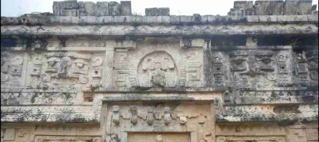
- Temple of the Carved Panels contains some of Chichen Itza’s finest stone relief work, often overlooked by visitors rushing to iconic structures
- The Xtoloc Cenote area provides sacred water source context rarely explored, revealing insights into Maya ceremonial practices
- Early morning exploration (8:00-9:30 AM) and late afternoon hours (4:00-5:30 PM) create optimal conditions for discovering quiet zones
- Southern archaeological zone structures like the Market and Steam Bath Complex demonstrate daily Maya life beyond monumental architecture
- Specialized photography angles from lesser-visited vantage points capture unique perspectives of major monuments without crowds
Discovering Chichen Itza Beyond the Iconic Monuments
While millions flock to photograph El Castillo and the Great Ball Court, Chichen Itza’s 740-hectare archaeological complex conceals dozens of lesser-known structures that offer equally profound insights into Maya civilization. These hidden gems provide intimate encounters with ancient architecture, revealing the sophisticated urban planning, religious practices, and daily life that made Chichen Itza one of Mesoamerica’s most powerful cities between 600-1200 CE.
The archaeological site contains over 80 documented structures, yet most visitors explore fewer than 10 during their visit. This concentration creates opportunities for those willing to venture beyond the main plaza to experience Chichen Itza’s architectural diversity in relative solitude. The lesser-known buildings showcase exceptional craftsmanship, unique architectural innovations, and cultural significance that equals the famous monuments, yet they remain peacefully uncrowded throughout peak season.
Understanding where these hidden treasures lie requires knowledge of the site’s layout and historical development. Chichen Itza evolved through multiple construction phases spanning six centuries, creating distinct architectural zones that reflect different periods of Maya influence, Toltec integration, and regional artistic styles. The structures explored in this guide represent the full spectrum of this cultural evolution, from pure Maya architectural traditions to the syncretic fusion that defines Chichen Itza’s unique character.
Strategic timing and routing transform the experience of discovering these secret spots. Early morning and late afternoon hours create optimal conditions when the majority of tour groups concentrate on the central monuments. The pathways leading to peripheral structures offer shaded walks through reconstructed sections of ancient Maya landscape, where wildlife encounters and botanical diversity add natural dimensions to the archaeological exploration.
People Also Ask About Chichen Itza Hidden Gems
What are the most overlooked structures at Chichen Itza worth visiting?
The Temple of the Carved Panels (Temple of the Sculptured Panels) ranks among the most underappreciated structures despite containing extraordinary stone relief work depicting warriors, priests, and ceremonial scenes. The High Priest’s Temple (Osario) offers architectural sophistication comparable to El Castillo but attracts minimal crowds. The Group of a Thousand Columns complex demonstrates urban planning genius with its extensive colonnaded halls, marketplaces, and administrative buildings that supported Chichen Itza’s estimated population of 50,000 inhabitants. The Platform of Venus showcases astronomical alignment precision with intricate carvings honoring the Maya calendar’s Venus cycle. These structures collectively reveal aspects of Maya civilization that the famous monuments cannot fully convey alone.
Where can you find quiet areas for photography at Chichen Itza?
The southern archaeological zone beyond the Osario Pyramid provides exceptional photography opportunities with minimal visitor presence. The path toward the Xtoloc Cenote leads through partially restored structures where morning light creates dramatic shadows across ancient stonework. The western platform areas near the Platform of Eagles and Jaguars offer clear sightlines to El Castillo from elevated positions, creating foreground-background compositions impossible from the crowded main plaza. The colonnade sections surrounding the Temple of Warriors become photography sanctuaries during midday when most visitors concentrate on shaded areas, allowing long-exposure captures of architectural details. The forest paths connecting peripheral structures provide natural frames for monument photography, incorporating the Yucatan jungle environment into compositions.
Are there hidden cenotes or water features beyond the main Sacred Cenote?
The Xtoloc Cenote represents Chichen Itza’s second major water source and played crucial roles in daily water supply rather than primarily ceremonial functions like the Sacred Cenote. Located in the southern archaeological zone, this circular limestone sinkhole measures approximately 40 meters in diameter and provided year-round fresh water for the city’s population. The Maya constructed elaborate stone platforms and access staircases descending to water level, demonstrating sophisticated hydraulic engineering. While swimming is prohibited and the cenote area receives less development than the Sacred Cenote, observation platforms allow visitors to appreciate the geological formation and understand the critical importance of cenotes to Maya settlement patterns. Archaeological evidence suggests the Xtoloc Cenote area served as a focal point for residential neighborhoods, with numerous domestic structures surrounding the water source.
What architectural features distinguish the lesser-known temples from famous structures?
Lesser-known structures often preserve original architectural details that have eroded or been heavily restored on the famous monuments. The Temple of the Carved Panels retains intricate stone relief work with sharper definition than more exposed structures, allowing detailed study of Maya sculptural techniques. Many peripheral buildings showcase pure Maya architectural traditions predating Toltec influence, featuring rounded corners, Maya vault construction, and decorative motifs distinct from the angular Toltec-Maya fusion visible on El Castillo. The Platform of Venus demonstrates astronomical precision through its orientations and proportions, with calculations embedded in the structure’s dimensions that track Venus’s synodic period. Several structures in the Group of a Thousand Columns complex display experimental architectural approaches, including hybrid roof systems and innovative column spacing that reveal Maya architectural evolution. These features provide architectural historians and enthusiasts with examples of construction techniques and design philosophy less visible on heavily visited monuments.
Extended multi-day tours – 5+ days
Featured Chichen Itza Multi-Day Tour Packages
3 days
Chichen Itza 3-Day Discovery Tour
- ✓ Comprehensive Chichen Itza experience
- ✓ Expert local guides included
- ✓ All accommodation included
- ✓ Transportation provided

5 days
Chichen Itza 5-Day Highlights Experience
- ✓ Comprehensive Chichen Itza experience
- ✓ Expert local guides included
- ✓ All accommodation included
- ✓ Transportation provided

7 days
Chichen Itza 7-Day Cultural Journey
- ✓ Comprehensive Chichen Itza experience
- ✓ Expert local guides included
- ✓ All accommodation included
- ✓ Transportation provided
10 days
Chichen Itza 10-Day Complete Adventure
- ✓ Comprehensive Chichen Itza experience
- ✓ Expert local guides included
- ✓ All accommodation included
- ✓ Transportation provided
Multi-day tour packages powered by TourRadar. Prices and availability subject to change.
The Southern Archaeological Zone: Exploring Beyond the Main Plaza
The southern section of Chichen Itza contains some of the site’s most architecturally sophisticated yet least visited structures. This zone developed as an elite residential and ceremonial district during Chichen Itza’s Classic Period (600-900 CE), predating the major Toltec-influenced constructions in the northern plaza. The architectural style reflects pure Maya traditions from the Puuc region, characterized by elaborate stone mosaics, rounded corners, and intricate geometric patterns.
The pathway leading south from the main plaza transitions through gradually thinning crowds as visitors prioritize the iconic northern monuments. Within 200 meters of leaving the central zone, the visitor density drops dramatically, creating opportunities for contemplative exploration among structures that once housed Chichen Itza’s ruling elite. The southern zone encompasses approximately 60 documented structures, though many remain unrestored and overgrown with jungle vegetation, preserving an authentic sense of archaeological discovery.
The High Priest’s Temple (Osario) serves as the southern zone’s anchor monument, rising 10 meters above the plaza floor with architectural proportions deliberately echoing El Castillo. This step-pyramid features nine ascending levels representing the nine levels of the Maya underworld (Xibalba), with a temple sanctuary at the summit containing remarkably preserved murals depicting Xibalban deities and the Hero Twins mythology. The structure’s name derives from a vertical shaft discovered in the 1890s that descends 12 meters into a natural cave system where archaeologists found multiple burials and ceremonial offerings, confirming the temple’s function as a sacred portal between the living world and the underworld.
The archaeological significance of the Osario extends beyond its architectural beauty. The temple demonstrates Chichen Itza’s Maya engineers’ understanding of cenote geology, deliberately positioning the structure above a natural cave system that connects to the regional underground water table. This placement reflects the Maya cosmological belief that caves and cenotes served as literal entrances to Xibalba, making the Osario both a architectural monument and a sacred geological feature. The integration of natural limestone formations into ceremonial architecture represents one of Maya civilization’s most distinctive religious-architectural achievements.
Adjacent to the Osario, the Platform of Venus showcases astronomical sophistication through its carefully calculated dimensions and orientations. This low rectangular platform measures 25 by 25 meters with four staircases aligned to the cardinal directions, creating perfect symmetry. The platform’s base decorations feature interlocking stone reliefs depicting the feathered serpent consuming human hearts, symbolizing Venus’s transformation between morning and evening star. Archaeological measurements reveal that the platform’s proportions encode the 584-day Venus synodic period, with the building’s dimensions creating mathematical relationships that track Venus’s apparent motion across the sky.
The Venus platform functioned as an observation point and ceremonial stage for astronomical rituals timed to Venus’s appearances. Maya astronomers recognized Venus’s predictable cycle and incorporated this knowledge into their calendar systems and agricultural planning. The platform’s orientation creates alignments with Venus’s maximum elongation points on the horizon, allowing priests to predict the planet’s visibility with precision. This astronomical-architectural integration demonstrates the Maya’s advanced mathematical capabilities and their practical application of astronomical knowledge to religious ceremony and societal organization.
The Group of a Thousand Columns: Urban Infrastructure Revealed
The Group of a Thousand Columns complex represents one of Chichen Itza’s most impressive architectural achievements, yet it receives only a fraction of the attention devoted to the central monuments. This extensive colonnade system covers approximately 15,000 square meters, creating covered walkways, market spaces, administrative halls, and elite residential areas that supported the city’s commercial and governmental functions. The complex’s name accurately describes its most striking feature: hundreds of cylindrical stone columns arranged in precise rows that once supported wooden beam roofs creating vast covered spaces.
The columns themselves demonstrate remarkable engineering consistency. Each column measures approximately 2.5 meters in height and 40 centimeters in diameter, carved from single limestone blocks or assembled from precisely fitted drums. The spacing between columns maintains consistent 2-meter intervals, creating modular architectural units that could be expanded or modified as the city grew. This standardization reveals sophisticated urban planning principles and centralized architectural control over public construction projects.
Archaeological evidence indicates the colonnade roofs utilized perishable materials—timber beams supporting palm thatch or wooden shingles—explaining why the roof systems have completely vanished while the stone columns remain standing. The column arrangements create natural ventilation patterns, allowing breeze circulation through the covered spaces while providing shade from the Yucatan’s intense tropical sun. This climate-responsive architecture enabled year-round use of the spaces for commercial activities, administrative functions, and social gatherings that required protection from weather extremes.
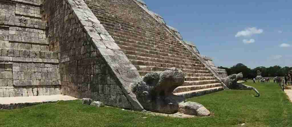
The Temple of Warriors anchors the northern edge of the colonnade complex, rising 12 meters above the surrounding plaza. This temple’s architectural design blends Maya and Toltec elements, featuring a steep pyramid base supporting a flat-roofed temple sanctuary accessed by a dramatic 60-step staircase flanked by feathered serpent columns. The temple’s name derives from the extensive carved relief panels depicting warriors, prisoners, and battle scenes that cover the lower platform walls, providing rare visual documentation of Maya-Toltec military practices and warrior costumes.
The Chac Mool sculpture positioned at the Temple of Warriors’ entrance represents one of Mesoamerica’s most distinctive sculptural forms. This reclining figure holds a ceremonial plate on its abdomen, which archaeological research suggests received offerings of incense, flowers, or possibly human hearts during ritual ceremonies. The Chac Mool’s stylistic origins trace to central Mexican Toltec culture, marking this sculpture as evidence of long-distance cultural exchange between Tula (the Toltec capital) and Chichen Itza during the Terminal Classic period (900-1000 CE).
Beyond the Temple of Warriors, the colonnade complex extends eastward and southward in progressively less restored sections. These peripheral areas reveal the archaeological reality of Chichen Itza: most structures remain partially excavated, with original stone construction visible alongside jungle vegetation reclaiming the ancient city. Walking through these transitional zones provides authentic encounters with archaeological preservation challenges and the immense scale of Chichen Itza’s urban footprint during its peak occupation period.
Temple of the Carved Panels: Masterpiece of Stone Relief Work
The Temple of the Sculptured Panels (also known as the Temple of the Carved Panels) stands among Chichen Itza’s most artistically significant structures, yet its location east of the central plaza places it beyond most visitors’ standard routes. This rectangular platform temple measures approximately 18 by 8 meters, with walls completely covered in intricate stone relief carvings that rank among the finest examples of Maya sculptural achievement preserved at any archaeological site.
The relief panels depict complex ceremonial scenes featuring priests, warriors, deities, and supernatural beings engaged in ritual activities. The carving technique demonstrates exceptional skill, with figures rendered in remarkably shallow relief (typically 2-3 centimeters deep) that creates subtle three-dimensional effects through precise stone removal and surface texturing. The sculptors achieved extraordinary detail in costume elements, facial features, and hieroglyphic inscriptions, all executed with stone tools and abrasive techniques that required tremendous time investment and specialized expertise.
The panels’ narrative content provides invaluable insights into Maya ceremonial practices and religious beliefs. Multiple scenes show elaborately costumed figures holding ceremonial staffs, incense burners, and ritual objects, surrounded by hieroglyphic texts that identify specific dates, deities, and ceremonial contexts. Several panels depict the Vision Serpent—a supernatural entity that appears in Maya bloodletting rituals—emerging from ceremonial bowls, confirming that this temple served religious functions related to elite bloodletting ceremonies and ancestral communication rituals.
The preservation quality of the Temple of Carved Panels exceeds that of more exposed monuments due to its relatively sheltered location and limited visitor traffic. Many relief details remain crisp and readable, allowing detailed photographic documentation and epigraphic study impossible on more weathered structures. The temple’s eastern orientation creates optimal morning light conditions that accentuate the relief depth through shadow play, transforming the static carvings into dynamic visual narratives that shift with the sun’s movement.
The architectural context surrounding the Temple of Carved Panels suggests it formed part of an elite residential compound or specialized ceremonial precinct. Adjacent structures include small palace-type buildings with interior benches, storage rooms, and residential features that indicate sustained occupation by high-status individuals. This clustering pattern—ceremonial temple surrounded by residential structures—represents a common Maya urban planning approach that integrated religious, administrative, and domestic functions within bounded architectural complexes.
The Xtoloc Cenote and Southern Water Management System
The Xtoloc Cenote represents Chichen Itza’s most important water source for domestic consumption, contrasting with the Sacred Cenote’s primarily ceremonial functions. Located approximately 400 meters south of the main plaza, this circular sinkhole measures 40 meters in diameter and maintains year-round water levels 20 meters below the ground surface. The cenote’s reliable water supply enabled permanent settlement in this region of the Yucatan Peninsula, where surface rivers and streams are completely absent due to the porous limestone geology.
The Maya developed sophisticated infrastructure around the Xtoloc Cenote to facilitate water access and manage the sacred-domestic duality of cenote functions. Stone-paved pathways descend the cenote walls at carefully graded angles, creating stable access routes for water carriers to reach the water surface with ceramic vessels. Platform areas at multiple levels provided resting points and ceremonial spaces where water-fetching activities could be conducted with appropriate ritual observances, acknowledging the cenote’s spiritual significance while serving practical water supply needs.
Archaeological excavations around the Xtoloc Cenote have revealed extensive residential structures concentrated within 200 meters of the water source. These buildings display typical Maya domestic architecture: rectangular platforms supporting perishable superstructures, exterior cooking areas with fire-cracked stone evidence, and refuse deposits containing domestic pottery, food remains, and tool fragments. The residential density around Xtoloc suggests this area housed substantial populations engaged in daily water collection, likely organized through neighborhood systems that regulated access rights and maintenance responsibilities.
The cenote itself contains archaeological deposits spanning Chichen Itza’s entire occupation sequence. Underwater explorations have recovered ceramic vessels, stone tools, and skeletal remains dated from the Early Classic period (250-600 CE) through the Terminal Classic (900-1000 CE), documenting continuous ceremonial use alongside domestic water extraction. The offering patterns at Xtoloc differ markedly from the Sacred Cenote, with fewer high-value items like gold and jade, and more abundant everyday ceramics and utilitarian objects, reinforcing the interpretation of Xtoloc as a community water source rather than exclusively elite ceremonial destination.
The geological formation of the Xtoloc Cenote illustrates the karst processes that created the Yucatan Peninsula’s distinctive landscape. The circular sinkhole formed through gradual limestone dissolution by slightly acidic rainwater percolating through the porous bedrock. Over thousands of years, subsurface cavities enlarged until the overlying rock collapsed, creating the open cenote structure. The water level within Xtoloc connects to the regional underground water table that extends throughout the northern Yucatan, creating an invisible freshwater reservoir that sustained Maya civilization for over a millennium.
The Market Complex and Evidence of Daily Economic Life
The Market (El Mercado) structure complex occupies the southwestern corner of the Group of a Thousand Columns area, representing rare archaeological evidence of Maya commercial activities and economic exchange systems. This extensive platform measuring approximately 90 by 50 meters supported numerous small buildings, stalls, and covered spaces where merchants displayed goods, conducted transactions, and engaged in the specialized economic activities that supported Chichen Itza’s role as a regional commercial hub.
The Market’s architectural layout reflects sophisticated understanding of commercial space organization. The platform perimeter features raised foundations for permanent vendor structures, while the central plaza area remained open for temporary stall placement and customer circulation. Numerous stone rings set into the platform surface at regular intervals provided anchor points for awning supports, allowing vendors to create shaded display areas using textile covers or palm thatch. This flexible architectural system accommodated different market scales and seasonal variations in commercial activity.
Archaeological excavations within the Market area have recovered extensive artifact assemblages documenting the goods traded at Chichen Itza. Obsidian blades and cores from sources in highland Guatemala indicate long-distance trade networks spanning hundreds of kilometers. Marine shell ornaments and raw materials from both Caribbean and Pacific coasts demonstrate Chichen Itza’s position as a crossroads connecting coastal and interior trade routes. Ceramic vessels representing styles from across Mesoamerica confirm that Chichen Itza attracted merchants from distant regions, creating a cosmopolitan commercial environment where diverse cultural groups interacted and exchanged both goods and ideas.
The Market’s proximity to the Group of a Thousand Columns administrative complex reflects intentional urban planning that facilitated economic regulation and tax collection. Elite administrators occupying the colonnaded buildings could directly oversee market activities, enforce trade regulations, and collect tribute payments or market taxes that supported Chichen Itza’s ruling class. This physical integration of commercial and governmental functions represents a common Maya urban planning strategy visible at major sites throughout the Maya lowlands.
The Market complex includes several specialized structures that supported commercial activities. A steam bath (temazcal) building attached to the market’s eastern edge provided purification facilities for travelers arriving to conduct trade. The Maya considered steam baths essential for both physical cleansing and spiritual purification, particularly before engaging in important commercial transactions or social interactions. The presence of a steam bath within the market complex indicates that trade activities carried religious and ceremonial dimensions beyond purely economic exchange, reflecting the Maya’s integrated worldview where economic, religious, and social spheres interconnected fundamentally.
Platform of Eagles and Jaguars: Symbolic Architecture of Power
The Platform of Eagles and Jaguars stands immediately adjacent to the Platform of Venus in Chichen Itza’s central plaza, yet its smaller size (approximately 15 by 15 meters) causes many visitors to overlook this structure while photographing the nearby monuments. The platform’s four stairways create a symmetrical plan aligned to the cardinal directions, with each stairway balustrade decorated with three-dimensional sculptures depicting eagles and jaguars devouring human hearts—powerful symbols of warrior orders and sacrificial practices in Toltec-Maya religious ideology.
The sculptural program adorning this platform represents some of Chichen Itza’s most dramatic stone carving. The eagle and jaguar figures emerge from the balustrade panels as high-relief sculptures with beaks and jaws opened to reveal human hearts clutched within. The carving style demonstrates clear Toltec influence, matching sculptural programs at Tula (the Toltec capital in central Mexico) and suggesting direct artistic exchange or even the presence of Toltec sculptors working at Chichen Itza during the Terminal Classic period.
The platform’s iconographic program communicates explicit messages about warrior ideology and sacrificial practices. Eagles and jaguars represented the two primary warrior orders in Toltec society—the Eagle Warriors and Jaguar Warriors—who occupied elite positions within the military hierarchy and performed specialized ceremonial roles including capturing prisoners for sacrifice. The heart imagery directly references human sacrifice rituals where hearts were extracted from living victims and offered to solar deities, particularly Tonatiuh (the Toltec sun god) who required regular blood offerings to maintain cosmic order and ensure the sun’s continued movement across the sky.
The architectural function of the Platform of Eagles and Jaguars likely involved ceremonial displays related to warfare and sacrifice. The platform’s low profile (approximately 1.5 meters high) creates an ideal stage for ritual performances visible to audiences gathered in the surrounding plaza. Historical sources describe Mesoamerican ceremonies where warriors displayed captured enemies, performed ritual combats, or conducted sacrifice preparations on similar platforms, creating public spectacles that reinforced social hierarchies and demonstrated the ruling class’s connection to supernatural powers.
The platform’s strategic location in the central plaza places it within a carefully orchestrated ceremonial landscape. Its position creates sightline relationships with El Castillo, the Great Ball Court, and the Temple of Warriors, forming a monumental complex where different ceremonial activities could unfold in coordinated sequences. During major festivals or astronomical events, processions might move between these structures following ritual protocols, with each platform serving as a station where specific ceremonies occurred as part of larger multi-day observances.
The Akab Dzib: Mysterious Writing and Elite Residence
The Akab Dzib (“Dark Writing” in Yucatec Maya) ranks among Chichen Itza’s oldest standing structures, with architectural features and construction techniques dating to the Early Classic period (500-600 CE). This complex palace building measures approximately 50 meters in length, featuring multiple rooms, interior doorways, and the distinctive architectural elements of the Puuc Maya style that dominated the Yucatan region before Toltec influence transformed Chichen Itza’s architectural character.
The structure’s enigmatic name derives from hieroglyphic inscriptions carved on interior lintels above doorways, rendered in shadow where light barely penetrates the rooms’ depths. The glyphs remain partially undeciphered, contributing to the building’s mysterious reputation. The visible portions of the inscriptions record dates in the Maya Long Count calendar system, placing the building’s construction or dedication ceremonies in the 6th or 7th century CE, making Akab Dzib one of the earliest dated monuments at Chichen Itza.
The architectural style of Akab Dzib exemplifies pure Maya building traditions before contact with Toltec culture. The structure utilizes the corbel vault construction technique—the Maya’s distinctive architectural innovation where stone courses overlap progressively until meeting at the apex, creating pointed arch-shaped interior spaces without true voussoir arches. The exterior facade features geometric stone mosaic patterns characteristic of Puuc architecture, with precisely cut limestone veneer blocks arranged in intricate designs including step-frets, lattices, and stacked masks representing the rain god Chaac.
The building’s interior organization reveals its function as an elite residential palace. Multiple rooms of varying sizes connect through narrow doorways, creating private chambers suitable for sleeping, storage, and domestic activities. Several rooms contain stone benches built against walls, providing furniture for sitting or sleeping. The largest interior chamber features a raised platform area that likely served as a throne dais or formal reception space where the resident noble received visitors and conducted administrative business.
One of Akab Dzib’s most intriguing features is a small interior chamber containing a handprint impression pressed into the stucco wall while the plaster remained wet. The handprint appears deliberately placed rather than accidental, leading archaeologists to interpret it as a ceremonial mark or dedication offering made during the building’s construction. Similar handprints appear in elite Maya residences throughout the Yucatan region, possibly representing the builder’s signature, a dedication to the structure’s patron deity, or an apotropaic symbol intended to protect the building and its inhabitants from supernatural harm.
The Akab Dzib’s location in the southern archaeological zone, surrounded by other Classic period structures, places it within Chichen Itza’s original settlement core before the city’s massive expansion during the Terminal Classic period. This early zone represents Chichen Itza’s development as a traditional Maya city-state before the Toltec cultural influences transformed the site into the syncretic ceremonial center that dominates the northern plaza. Exploring Akab Dzib provides context for understanding Chichen Itza’s evolution across six centuries of continuous occupation and architectural innovation.
Strategic Exploration: Timing and Routes for Discovering Hidden Areas
Successfully experiencing Chichen Itza’s hidden gems requires strategic planning regarding timing, routing, and visitor flow patterns. The archaeological site opens daily at 8:00 AM, with the first hour providing optimal conditions for exploring peripheral structures before tour bus arrivals between 9:30-10:00 AM bring large groups that concentrate on the central monuments. Early morning visitors who proceed directly to southern or eastern structures can achieve 45-60 minutes of private exploration before significant crowds arrive.
The ideal exploration route begins at the site entrance, proceeds immediately south toward the Osario Pyramid and southern zone structures, then works northward through the Group of a Thousand Columns before concluding at the central plaza monuments when crowds have dispersed during late afternoon hours (after 4:00 PM). This counter-clockwise routing pattern moves against the prevailing visitor flow direction, maximizing opportunities to experience structures in relative solitude.
The pathway network connecting Chichen Itza’s structures varies significantly in quality and shade coverage. The main north-south axis connecting the entrance to the central plaza features wide, well-maintained gravel paths with minimal shade, becoming intensely hot during midday hours (11:00 AM – 3:00 PM). Secondary paths leading to peripheral structures often follow narrower routes through partially forested areas, providing natural shade that makes afternoon exploration feasible when the main plaza becomes overwhelmingly hot.
Wildlife encounters increase significantly when exploring peripheral structures, particularly during early morning and late afternoon hours when animal activity peaks. The archaeological zone supports populations of coatis (tejón), agoutis (sereque), tropical birds including Montezuma oropendolas and great kiskadees, and occasionally spider monkeys in forested areas. These wildlife sightings add natural dimensions to the archaeological experience, connecting the ancient Maya’s relationship with the Yucatan jungle ecosystem to contemporary conservation efforts that protect both cultural and natural heritage.
Photographic considerations influence optimal exploration timing for specific structures. Morning light (7:00-10:00 AM) provides warm, directional illumination ideal for photographing east-facing facades like the Temple of Carved Panels, creating shadow contrast that emphasizes relief depth. Late afternoon light (4:00-6:00 PM) favors west-facing structures and creates dramatic backlighting effects when photographing El Castillo or the Great Ball Court from peripheral vantage points. Cloud cover during the rainy season (May-October) produces soft, diffused lighting that eliminates harsh shadows, creating ideal conditions for photographing architectural details without extreme contrast.
The site’s drinking water and rest facilities concentrate near the entrance and central plaza, with no facilities available in peripheral zones. Successful all-day exploration requires carrying adequate water (minimum 2-3 liters per person) and planning strategic returns to the entrance area for restroom access and water refills. The lack of facilities in peripheral areas contributes to their uncrowded character, as most visitors remain close to amenities concentrated in the developed tourism zones.
Photography Techniques for Capturing Hidden Architectural Details
Photographing Chichen Itza’s lesser-known structures presents both challenges and opportunities distinct from photographing the famous central monuments. The reduced visitor presence enables long-exposure techniques, tripod positioning, and patient composition development impossible in crowded areas. However, many peripheral structures lack clear access paths and viewing platforms, requiring careful positioning to achieve clean compositions without safety barriers or vegetation obscuring architectural elements.
Wide-angle lenses (16-35mm equivalent) prove essential for capturing complete structures within tight spaces where limited setback distance prevents full building views with standard focal lengths. The Group of a Thousand Columns area particularly benefits from wide-angle coverage, allowing photographers to convey the extensive colonnade system’s scale while including contextual elements like jungle vegetation or distant monuments. Ultra-wide perspectives (14mm or wider) create dramatic emphasis on architectural verticality when photographing the Osario or Temple of Warriors from close vantage points.
Detail photography using macro or telephoto lenses (100-200mm) captures the intricate stone carving work that distinguishes structures like the Temple of Carved Panels. Close-focusing capabilities enable documentation of hieroglyphic inscriptions, relief sculpture textures, and construction techniques visible in exposed masonry joints. The superior preservation quality of lesser-visited structures often allows detail photography impossible on weathered central monuments, creating opportunities to document architectural features that illuminate Maya construction methods and artistic achievements.
Time-lapse photography techniques create compelling documentation of light movement across architectural surfaces throughout the day. Setting a camera on tripod at a peripheral structure like the Platform of Venus and capturing images every 5-10 minutes for several hours produces sequences showing shadow patterns shifting across carved reliefs, revealing details invisible in static photographs. These sequences also document visitor flow patterns, typically showing the dramatic concentration of crowds at central monuments while peripheral structures remain empty despite their architectural and historical significance.
Black and white photography emphasizes architectural form, texture, and geometric relationships without the distraction of color information. The Yucatan limestone’s uniform pale gray color often creates low contrast in color photographs, particularly during bright midday conditions. Converting images to black and white during post-processing allows precise tonal control that accentuates relief depth, surface textures, and architectural proportions. High-contrast black and white treatments create graphic interpretations that emphasize the geometric precision and monumental scale of Maya architecture.
Panoramic photography techniques using multi-image stitching capture the extensive horizontal dimensions of structures like the Group of a Thousand Columns that exceed single-frame coverage. Shooting overlapping images in sequence and merging them during post-processing creates ultra-high-resolution panoramas documenting complete architectural complexes with detail levels impossible in standard photographs. These panoramic compositions convey spatial relationships between structures, environmental context, and the integration of architecture within the landscape in ways that approximate the actual experience of standing within the archaeological site.
Conservation Challenges and Archaeological Preservation Efforts
The lesser-known structures at Chichen Itza face distinct conservation challenges compared to the heavily monitored and maintained central monuments. Many peripheral buildings remain partially excavated, with original stone construction emerging from accumulated soil and vegetation in various states of archaeological exposure. This partial restoration creates authentic encounters with the archaeological preservation process, revealing the gradual work of uncovering, stabilizing, and documenting ancient architecture that continues throughout the site.
The Group of a Thousand Columns exemplifies the conservation challenges inherent in extensive architectural complexes. The hundreds of stone columns require individual stabilization to prevent collapse, with many columns leaning at precarious angles due to foundation settlement and root system intrusion. Conservation teams must decide whether to aggressively restore leaning columns to vertical positions—risking structural damage during manipulation—or to stabilize columns in their current positions while accepting non-original orientations. These decisions involve complex considerations balancing archaeological authenticity, structural stability, and visitor safety.
Vegetation management represents an ongoing challenge for all peripheral structures. The Yucatan’s tropical climate enables rapid plant growth, with tree roots penetrating masonry joints and creating structural instability as root systems expand. Conservation teams conduct regular vegetation removal focusing on eliminating woody plants whose root systems threaten stonework while allowing grass and low herbaceous growth that stabilizes soil and prevents erosion. This selective approach creates the park-like landscape visible throughout the archaeological zone, balancing aesthetic considerations with structural preservation requirements.
The Temple of Carved Panels’ exceptional relief preservation results from deliberate conservation interventions that protected the carved surfaces from weathering. During restoration work in the 1990s, conservators applied specialized consolidants that penetrate the limestone surface and strengthen the stone matrix without altering visual appearance. These treatments slow the erosion processes that have degraded more exposed sculptures, extending the period during which the relief details remain legible to visitors and researchers. However, consolidant application remains controversial within conservation communities due to concerns about unknown long-term effects and the permanent chemical alteration of archaeological materials.
Climate change presents emerging threats to Chichen Itza’s conservation requiring adaptive management strategies. Increasingly intense rainfall events during the hurricane season accelerate erosion of exposed stonework and saturate foundations, potentially causing structural instability. Rising temperatures increase biological activity including lichen growth and insect colonization that degrade stone surfaces. Conservation teams now incorporate climate projection modeling into long-term preservation planning, attempting to anticipate future conditions and develop proactive interventions that protect structures from predicted environmental changes.
Frequently Asked Questions About Chichen Itza Hidden Gems
Can you access all structures at Chichen Itza or are some restricted?
Visitors can approach most peripheral structures for exterior viewing and photography, but climbing or entering buildings is prohibited throughout Chichen Itza to prevent structural damage and ensure visitor safety. The restriction extends to all monuments including lesser-known structures in peripheral zones. Barrier ropes and signage mark the permitted approach distances, typically allowing visitors within 2-3 meters of building foundations. Some structures remain completely off-limits due to active conservation work or structural instability, with temporary fencing and closure notices posted. The Sacred Cenote and Xtoloc Cenote both prohibit swimming or water contact, with observation platforms providing safe viewing access. Despite access restrictions, the permitted viewing distances enable excellent photography and architectural appreciation for all publicly accessible structures.
How much time should you allocate to explore hidden areas beyond the main monuments?
Comprehensive exploration of Chichen Itza’s peripheral structures requires minimum 4-5 hours beyond the time devoted to the central plaza monuments. A full-day visit (6-8 hours) enables thorough coverage of the southern archaeological zone, Group of a Thousand Columns, and eastern structures while allowing time for photography, rest breaks, and detailed observation. Early arrival (8:00 AM opening) combined with remaining until late afternoon (5:30 PM last entry) creates optimal conditions for experiencing both famous and hidden structures. Visitors with limited time should prioritize 2-3 specific peripheral structures based on personal interests—such as the Temple of Carved Panels for art enthusiasts or the Group of a Thousand Columns for architecture focus—rather than attempting rushed coverage of all areas. The extensive walking distances between structures necessitate realistic time planning, with distances from the entrance to the furthest southern structures approaching 800 meters each direction.
Are there guided tours that specifically focus on lesser-known structures?
Specialized archaeological tours focusing on Chichen Itza’s peripheral structures and lesser-known monuments are available through select tour operators who employ professional archaeologists or advanced archaeology students as guides. These specialized tours typically last 4-6 hours and intentionally avoid the crowded central monuments during peak hours, instead concentrating on architectural details, historical context, and conservation challenges visible in peripheral zones. Private guide services offer customizable itineraries emphasizing specific interests like epigraphy, architectural history, or Maya astronomy. The standard group tours provided through most hotels and travel agencies concentrate overwhelmingly on the central plaza monuments with minimal time allocated to peripheral structures, making specialized archaeological tours essential for visitors seeking comprehensive site coverage. Independent exploration remains perfectly feasible with quality guidebooks or mobile apps providing structure identification and historical context without guided tour participation.
What is the best season for photographing less crowded structures?
The September-November period provides optimal conditions for photographing Chichen Itza’s peripheral structures with minimal visitor presence. These shoulder months fall after summer vacation peaks and before winter high season, creating significantly reduced crowding while maintaining favorable weather conditions. The late May-August rainy season brings afternoon thunderstorms but creates dramatic cloud formations and soft lighting ideal for architectural photography, with the added benefit of fewer visitors willing to risk weather disruptions. Early morning photography (8:00-9:30 AM) produces the best lighting conditions year-round regardless of season, with warm directional sunlight accentuating architectural relief and minimal visitor presence before tour group arrivals. Late afternoon hours (4:30-5:30 PM) provide similar crowd advantages with golden hour lighting that transforms limestone facades. The December-March high season brings optimal weather but maximum crowding, requiring strategic early arrival or late afternoon timing to achieve uncrowded photographs even at peripheral structures.
How does exploring hidden gems enhance understanding of Maya civilization?
The lesser-known structures reveal dimensions of Maya civilization invisible when examining only the monumental ceremonial architecture. The Market complex demonstrates economic systems and trade networks that sustained Chichen Itza’s population and political power. Residential structures around the Xtoloc Cenote show daily domestic life, water management practices, and neighborhood organization. The Group of a Thousand Columns illustrates administrative infrastructure and urban planning sophistication required to govern a city-state housing 50,000+ inhabitants. The Temple of Carved Panels preserves artistic achievement and religious iconography documenting specific ceremonies and deity concepts. Together, these diverse structures create a comprehensive portrait of Maya urbanism encompassing economic, political, religious, and domestic spheres that integrated into a functioning city rather than merely a ceremonial center. The peripheral structures make tangible the reality that Chichen Itza was a lived city where thousands of people conducted daily activities, engaged in commerce, administered government, and participated in religious ceremonies within an elaborately planned urban landscape.
Are there any structures with intact original paint or stucco decoration?
Most visible surfaces at Chichen Itza have lost their original painted stucco finishes due to weathering across centuries of exposure. However, several lesser-known structures preserve fragments of original polychrome decoration in protected locations. Interior chambers within the Osario Pyramid contain murals depicting underworld deities and mythological scenes rendered in red, blue, yellow, and black mineral pigments. The Upper Temple of the Jaguar (adjacent to the Great Ball Court) preserves painted stucco relief panels in interior rooms showing warriors, priests, and ceremonial processions in remarkably vivid colors despite 800+ years of age. The Temple of Carved Panels retains traces of red paint in deeply recessed relief areas protected from direct rainfall. These paint fragments reveal that Chichen Itza’s structures were originally vibrant with color, contradicting the modern perception of ancient Maya architecture as monochrome limestone. The protected interior locations containing the best-preserved paintings are typically restricted from visitor access to prevent deterioration, though photographs displayed in the site museum document these discoveries.
What role did the lesser-known structures play in Chichen Itza’s political power?
The peripheral structures housed the administrative infrastructure, economic systems, and elite residential complexes that sustained Chichen Itza’s political dominance across the northern Yucatan region. The Group of a Thousand Columns provided governmental office space, tribute storage facilities, and public assembly areas where political pronouncements were disseminated and administrative decisions implemented. The Market complex generated tax revenues through commercial regulation while serving as a diplomatic venue where foreign merchants and emissaries conducted negotiations with Chichen Itza’s ruling elite. Elite residential palaces like Akab Dzib housed the noble families and priestly lineages who advised rulers, managed specialized knowledge systems including astronomy and writing, and conducted the religious ceremonies that legitimized political authority through claims of divine sanction. The Osario and other pyramid-temples demonstrated Chichen Itza’s wealth and architectural capabilities to visiting dignitaries, creating visible expressions of power that reinforced diplomatic relationships and intimidated potential rivals. These diverse functions collectively enabled Chichen Itza to exercise regional political control extending across much of the northern Yucatan Peninsula during the Terminal Classic period.
How do architectural styles differ between the famous monuments and hidden structures?
Chichen Itza’s architectural evolution creates distinct stylistic differences between the famous northern monuments and the lesser-known southern structures. The southern zone buildings predominantly exhibit pure Maya Puuc architectural style characterized by elaborate stone mosaic facades, rounded building corners, Maya corbel vault construction, and decorative programs featuring Chaac masks and geometric patterns. These structures date primarily to the Classic period (600-900 CE) before intensive Toltec contact. The northern plaza monuments including El Castillo, the Great Ball Court, and Temple of Warriors display Toltec-Maya fusion architecture combining Maya construction techniques with Toltec iconography, Toltec columnar halls, warrior imagery, and reclining Chac Mool sculptures. The architectural transition reflects Chichen Itza’s transformation from a traditional Maya city-state to a cosmopolitan ceremonial center synthesizing cultural elements from across Mesoamerica. Experiencing both architectural zones provides visual documentation of this cultural evolution, making the contrasts between styles tangible in ways that textual descriptions cannot fully convey.
Can you visit Chichen Itza independently and still find the hidden gems effectively?
Independent exploration of Chichen Itza’s peripheral structures is entirely feasible and often preferable to group tour participation for visitors seeking comprehensive coverage of lesser-known areas. The site’s pathway system clearly connects all major structures with directional signage in Spanish and English. Quality guidebooks, downloadable audio tours, and mobile applications provide structure identification, historical context, and architectural details rivaling professional guide services. Independent visitors control their own pace and itinerary, enabling extended time at personally interesting structures without group schedule constraints. Site maps available at the entrance indicate all accessible structures, with labeled pathways showing routes to peripheral zones. The primary advantages of independent exploration include flexibility to pursue specific interests, ability to time visits for optimal photography light, and freedom to spend extended periods at uncrowded peripheral structures. Successful independent visits require physical stamina for extensive walking, adequate water and sun protection for all-day exploration, and willingness to navigate using maps and directional signage without human guide assistance.
What conservation ethics should visitors observe when exploring peripheral structures?
Responsible exploration of Chichen Itza’s lesser-known structures requires strict adherence to conservation ethics protecting archaeological materials for future generations. Never touch carved stone surfaces, as skin oils and physical contact accelerate deterioration of relief details and hieroglyphic inscriptions. Remain on designated pathways rather than climbing over foundation platforms or walking across unrestored structural remains where vegetation stabilizes fragile stonework. Never remove any objects from the archaeological zone including stone fragments, pottery sherds, or plant materials, as these materials contribute to ongoing research and ecosystem conservation. Respect barrier ropes and closure signs marking areas undergoing active conservation or containing structural hazards. Avoid direct sunlight exposure on interior spaces with preserved murals or painted surfaces, as ultraviolet radiation accelerates pigment degradation. Report observed damage or suspicious activities to site guards or visitor center personnel. These ethical practices ensure that Chichen Itza’s hidden architectural treasures remain accessible to future visitors while supporting the conservation efforts that protect this UNESCO World Heritage site’s universal value for humanity.