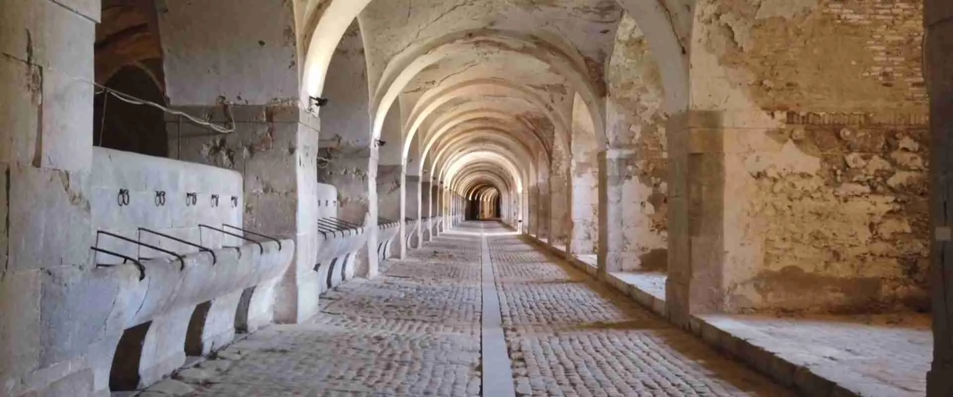
Bastioned Vaubanian Engineering: The Subterranean Vaults and Hydraulic Networks of Castell de Sant Ferran in Catalonia
Perched on a hill northwest of Figueres in Catalonia’s Alt Empordà plain, Castell de Sant Ferran represents the most ambitious application of Vaubanian military engineering on the Iberian Peninsula. Commissioned in 1753 to defend the French border following the territorial changes of the Treaty of the Pyrenees, the fortress encloses thirty-two hectares of bastioned ramparts, dry moat, and a subterranean infrastructure—five countermine galleries and four interconnected cisterns—engineered to sustain a full garrison across years of siege, inviting comparison with contemporaneous and later bastioned traditions from Japan to Mughal India.
Key Takeaways
- Castell de Sant Ferran is the largest bastioned fortress in Europe from the modern era, covering 32 hectares within an outer perimeter of approximately 3,125 meters, constructed between 1753 and 1766 under the direction of engineers Pedro Martín Cermeño and Juan Martín Cermeño commissioned by the Bourbon Crown.
- The fortress deploys six asymmetric bastions, seven ravelins, two counterguards, three hornworks, and five documented countermine galleries—a complete deployment of Vaubanian defensive doctrine intended to eliminate all dead ground before the curtain walls and detect enemy underground mining operations.
- Four subterranean cisterns beneath the central parade square store a combined nine million liters of water, sufficient to supply a garrison of several thousand soldiers for an extended period without any external water source—a strategic reserve insulated by barrel-vaulted limestone masonry and hydraulic plaster lining.
- The Besalú Bridge, documented since the eleventh century and largely reconstructed from 1316, integrates angular cutwater piers, a transitional Romanesque-Gothic arch sequence, and a fortified toll tower into a structure where hydrodynamic engineering and military chokepoint design are architecturally inseparable.
- Castell de Peralada, a medieval citadel in Alt Empordà rebuilt after a French incursion in 1285, illustrates the long arc from Gothic curtain wall construction to adaptive reuse, with its historic subterranean stone vaults now housing one of the region’s most distinctive wine museums.
- Vaubanian bastioned geometry reaches Japan in one of the most traceable cross-cultural transmissions in fortification history: Goryokaku in Hakodate, designed in 1855 by rangaku scholar Takeda Ayasaburō from Dutch-language military manuals that included Vauban’s works, represents the deliberate adoption of the bastioned trace tradition in East Asia.
People Also Ask About Bastioned Fortress Engineering
What makes Castell de Sant Ferran a landmark of Vaubanian bastioned military engineering?
Castell de Sant Ferran stands as the largest bastioned fortress in Europe from the modern era, enclosing 32 hectares within an outer perimeter of approximately 3,125 meters. Its significance lies less in its sheer size than in the complete, integrated deployment of the Vaubanian defensive system at a single site: six asymmetric bastions joined by curtain walls, a ten-hectare dry moat housing an outer ring of seven ravelins, two counterguards, and three hornworks, a covered way with firing positions along its full perimeter, and below ground, five countermine galleries and four cisterns with a combined capacity of nine million liters. This total articulation of bastioned trace theory—every element present and preserved—makes the fortress a three-dimensional reference document for 18th-century military engineering. Construction was directed by the Cermeño engineers, Pedro Martín Cermeño and Juan Martín Cermeño, commissioned by the Bourbon Crown to anchor the defense of the Alt Empordà invasion corridor. The resulting structure, though never seriously besieged, fulfilled its deterrent function across more than a century of military use and remains today the largest monument in Catalonia.
How do the subterranean cisterns and hydraulic networks at Castell de Sant Ferran function?
The four cisterns beneath the parade square at Castell de Sant Ferran operate as a passive hydraulic collection and storage system. Rainwater and surface runoff from the 12,000-square-meter paved parade ground above are directed through intake points into a filtration bed and then into four separate barrel-vaulted stone chambers. The chambers are lined with hydraulic plaster—a lime mortar incorporating crushed ceramic material—that renders the vault intrados and floor nearly impermeable. The underground position maintains temperatures between roughly twelve and sixteen degrees Celsius year-round, preventing evaporative loss and limiting bacterial growth in the stored water. The combined capacity of nine million liters was calculated to sustain several thousand soldiers without dependence on any external supply—a critical strategic requirement for a fortress designed to withstand siege in the pre-railway era. Visitors can now experience these spaces through La Catedral de l’Aigua (Cathedral of Water), a dedicated program offering boat exploration of the cistern galleries when illuminated from within, an experience that gives the vaulted chambers their name.
What is the purpose of countermine galleries in 18th-century bastioned fortress design?
Countermine galleries are subterranean tunnels excavated beneath the ramparts and outer works of a fortress to detect and neutralize enemy underground mining. The attacking mine—the most feared technique in siege warfare since the spread of gunpowder—required drilling a tunnel from outside the fortress to a point beneath a bastion or curtain wall, then packing the end cavity with powder to collapse the masonry above. The defender’s countermine gallery provided a listening network: at intervals along the tunnel, trained miners pressed their ear to the floor and walls, detecting the vibration of picks and shovels working in the surrounding earth. When a mine was located, defenders could break through into the enemy tunnel and fight underground, or detonate a smaller charge to collapse the approaching gallery before it reached the wall. Vauban formalized this subterranean surveillance system into standard doctrine. Castell de Sant Ferran’s five documented countermine galleries represent a full deployment of this layer beneath the outer defensive works, preserving both the physical tunnels and the architectural logic of underground military defense across two and a half centuries.
How do bastioned star fortress geometries compare across European and global military traditions?
The bastioned trace emerged in 15th and 16th-century Italy as the primary architectural response to artillery, spreading across Europe through shared engineering literature and the movement of trained military engineers between courts and campaigns. Vauban refined this tradition into a systematic doctrine that became the standard reference for fortification design across the Western world through the 18th century. The resulting bastioned geometries appear across a remarkable geographic range—from the Atlantic fortresses of Portugal and Spain to Prussian border towns and, by the 19th century, East Asia. The transmission to Japan via Takeda Ayasaburō’s studies of Dutch-language military manuals is one of the most documented cases of this spread; functional parallels at Mughal fortifications represent independent architectural responses to the same tactical problems of water supply, subterranean access, and controlled movement. Goryokaku in Hakodate (completed 1866) stands as the clearest non-European example of deliberate bastioned trace adoption, deploying a five-pointed star plan derived from Vauban’s principles approximately a century after Castell de Sant Ferran’s primary construction was complete.
Extended multi-day tours – 5+ days
Featured Barcelona Multi-Day Tour Packages
2 days
Montserrat, Girona and Costa Brava in 2 days from Barcelona
- ✓ Comprehensive Barcelona tour
- ✓ Expert local guides included
- ✓ All accommodation arranged
- ✓ Transportation provided

5 days
Best of Catalonia, Self-drive
- ✓ Comprehensive Barcelona tour
- ✓ Expert local guides included
- ✓ All accommodation arranged
- ✓ Transportation provided

7 days
Lisbon, Madrid and Barcelona
- ✓ Comprehensive Barcelona tour
- ✓ Expert local guides included
- ✓ All accommodation arranged
- ✓ Transportation provided
5 days
Trip to Barcelona in 5 Days
- ✓ Comprehensive Barcelona tour
- ✓ Expert local guides included
- ✓ All accommodation arranged
- ✓ Transportation provided
Multi-day tour packages powered by TourRadar. Prices and availability subject to change.
Military Engineering and the Vaubanian Legacy in 18th-Century Catalonia
The fortification traditions of Catalonia were shaped, more than in almost any other European region, by the volatility of the France–Spain border across the early modern period. The Treaty of the Pyrenees, signed in 1659, transferred Roussillon and part of Cerdanya from the Spanish Crown to France, shifting the international boundary south to the Pyrenean crests and exposing the Alt Empordà plain as the primary invasion corridor into Catalonia. This corridor presented no natural obstacles of strategic consequence: a broad agricultural lowland flanked by the Mediterranean to the east and gentle pre-Pyrenean hills to the west, traversed by Roman-era roads that led directly south through Girona toward Barcelona. Any hostile force advancing from Perpignan across the Empordà encountered nothing more than the scattered walls of market towns and isolated medieval towers before reaching the walls of Girona. The political urgency of changing this situation drove the most expensive single act of military construction in 18th-century Spain.
The fortification tradition available to the engineers tasked with solving this problem was decisively shaped by the work of Sébastien Le Prestre de Vauban, who served Louis XIV as commissaire général des fortifications from 1678 until his death in 1707. Vauban left behind a body of completed fortifications—over a hundred and fifty projects have been attributed to him or his office—and a set of treatises that circulated widely in manuscript among European military engineers throughout the 18th century. His innovations were less geometrical invention than systematic integration: the key elements of the bastioned trace had been developed by Italian engineers in the 15th and 16th centuries, but Vauban assembled them into a coherent, teachable doctrine of defensive depth that became the standard reference for the entire profession. His three published systems of increasing complexity and cost provided a scalable framework that any military engineering corps could adapt to the constraints of terrain, budget, and threat level.
By the mid-18th century, when the Spanish Bourbon Crown authorized construction of the fortress at Figueres, Vauban’s principles had been absorbed into the foundational training of military engineers throughout Europe, including those of the Spanish Real Cuerpo de Ingenieros, the engineering corps reformed and expanded under Philip V following the War of the Spanish Succession. The fortress commissioned at Figueres was not designed by Vauban—he had been dead for nearly half a century when the first stone was placed—but it was designed according to his system, applied with the local adaptations that Spanish engineers had developed through their own campaigns and institutional training. The Cermeño father-and-son team who directed the project worked within a professional tradition that read Vauban as foundational and adapted that tradition to the specific conditions of the Empordà: a wide flat plain with a clear prevailing threat direction from the north, a reliable local supply of limestone, and a royal client willing to commit resources at an exceptional scale. The result, named in honor of King Ferdinand VI of Spain—Sant Ferran in Catalan—was an engineering achievement that contemporaries recognized as the greatest bastioned fortress ever executed by Spanish military engineering.
The strategic context that justified this investment extended beyond simple border defense. The Alt Empordà corridor was not only the main invasion route for a French army moving south but also the principal line of communication between Catalonia and France in peacetime, a commercial artery whose control was economically and diplomatically significant. A fortress capable of garrisoning a maneuvering division—infantry, cavalry, and artillery together—at the head of this corridor could deter offensive operations, provide a base for counterattacks, and, if eventually surrounded, absorb siege resources that would otherwise be directed at Girona or Barcelona. The combination of deterrence, operational base, and delay function defined the fortress’s strategic rationale and drove every engineering decision about scale, subterranean infrastructure, and defensive depth.
Vauban’s Bastioned Trace: Geometric Principles of Polygonal Defense
The Bastion as Modular Defensive Unit
The central innovation of the bastioned trace, in its Vaubanian refinement, was the transformation of the curtain wall from a passive barrier into an active fire platform. In medieval fortification, walls were designed to be thick and tall, providing a high platform for defenders and a physical obstacle that attackers had to scale, breach, or undermine; the fundamental vulnerability was the base of the wall, which lay in a dead angle invisible from the parapet above and could be approached under the wall’s own profile. The widespread deployment of cannon during the 15th century changed the calculation entirely: a tall masonry wall was now a large target for flat-trajectory artillery, while the base remained a dead angle invisible to defenders. The bastioned trace answered both problems by projecting angular platforms—bastions—at regular intervals from the main curtain wall.
A bastion consists of two faces, which project toward the field at an angle relative to the curtain, and two flanks, which connect the face ends back to the curtain wall at something close to a right angle. From the flanks, defenders could direct fire along the full face of the adjacent curtain wall, covering precisely the dead ground at the foot of the wall that earlier towers could not effectively sweep. From the faces of one bastion, defenders could cover the faces of the adjacent bastions across the intervening curtain, creating an interlocking geometry of fire that left no section of the outer perimeter unswept. Every point on the outer wall could be defended by flanking fire from one or both adjacent bastions, and the foot of the wall was fully covered by the flanking cannon and musketry from those same positions.
The specific geometry of each bastion—the angle between the two faces, the length of the flanks, the angle between face and flank—was determined by the requirement that flanking fire from the flank reach the full length of the adjacent curtain. Vauban worked extensively on optimizing these ratios for different polygon sizes, and his treatises include detailed tables correlating the number of sides in the defensive polygon with the optimal bastion proportions. A too-acute salient angle made the bastion narrow and difficult to use for artillery; a too-obtuse angle reduced the effectiveness of flanking fire. The six-bastion hexagonal inner enclosure at Castell de Sant Ferran represents a polygon that military engineers of the period considered near-optimal: large enough to contain the full garrison infrastructure, with bastion angles that allowed effective flanking fire from the outer works as well as from the bastions themselves.
Flanking Fire, the Glacis, and the Elimination of Dead Ground
Eliminating dead ground required more than bastion geometry at the perimeter. The glacis—a long, gently sloping earthen embankment descending from the crest of the covered way toward the open plain—served a dual purpose that made it indispensable to the complete Vaubanian system. Crossing the glacis, an attacker came under direct fire from defenders on the fortress parapet, with no cover available on the open slope. Equally important, the glacis masked the lower portion of the curtain wall and bastions from the attacker’s artillery: cannon fire aimed at the wall struck the slope of the glacis instead, absorbing its energy in earth rather than transmitting it to masonry. The wall itself could only be seen from a battery positioned close enough to be within effective defensive fire, which meant that the attacker had to establish himself progressively closer to the fortress—through a sequence of parallel trenches—before he could bring his siege cannon to bear on the main walls.
The ravelins positioned in the moat—triangular earthworks projecting from the counterscarp—absorbed the first impact of any attack directed at the curtain wall gateways, forcing attackers to reduce the ravelin as a separate defended position before reaching the gates behind it. Each ravelin was itself protected by the flanking fire of the adjacent bastions, which meant it could only be approached from a narrow frontal axis that the attackers had to cover in the open. Counterguards, placed between the main bastions and the ravelins, added a further tier of masonry and earthwork between the attacker and the bastion faces. The covered way—the trench running along the inner lip of the outer moat slope, equipped with traverses and firing positions—provided a final defensive line that an attacker had to storm before he could reach the main scarp at all.
At Castell de Sant Ferran, this full system is preserved with exceptional completeness. The outer works include seven ravelins, two counterguards, and three hornworks—larger outworks projecting from the covered way to protect the more exposed sections of the approach—together with the covered way itself and the approximately ten-hectare dry moat in which all of this outer infrastructure is positioned. The total depth of the defensive system, from the outer edge of the glacis to the main ramparts, reaches several hundred meters in the most fully developed sectors, requiring any attacker to overcome multiple defended positions before approaching the curtain wall. This layered structure was designed specifically for the slow, methodical siege warfare of the 18th century, where the decisive factor was often logistical exhaustion rather than direct assault.
Castell de Sant Ferran: Commission, Construction, and Engineering Supervision
Royal Commission and the Cermeño Engineers
The first stone of Castell de Sant Ferran was placed on 13 March 1753, under the reign of Ferdinand VI of Spain, who gave the fortress his name in Catalan form: Sant Ferran honored Ferdinand the Saint rather than the reigning monarch directly, but the association with Bourbon royal authority was understood by all parties to the commission. The strategic imperative was clear: the loss of Roussillon under the Treaty of the Pyrenees had eliminated Spain’s northern Catalan defensive line, and the War of the Spanish Succession had demonstrated the vulnerability of the corridor to a French advance. The Spanish Real Cuerpo de Ingenieros had surveyed the Empordà terrain and identified the hill above Figueres—dominating the coastal plain and the main road from the north—as the best defensible position in the region. Construction was authorized and funded at a scale unprecedented in recent Spanish military engineering.
The engineering direction fell to Pedro Martín Cermeño and Juan Martín Cermeño, military engineers of the Real Cuerpo working within the Vaubanian professional tradition transmitted through their institutional training and through the published and manuscript engineering literature of the period. Primary construction was largely complete by 1766—some sources note that works on the outer defensive elements and internal installations continued into subsequent decades—representing a sustained construction effort of approximately thirteen years. The scale of the project required managing a labor force numbering in the thousands at peak phases, quarrying and transporting enormous quantities of limestone from local sources, and clearing a hilltop that had previously been occupied by a Capuchin monastery, which was relocated to accommodate the fortress footprint.
The fortress was designed at a scale that reflected its dual strategic role as deterrent and operational base. Stables for five hundred horses allowed the garrisoning of a cavalry contingent capable of sorties and counterattacks against a besieging force. Warehouses provisioned for ten thousand people for a year reflected the siege-endurance calculation: a fortress that could outlast a siege army’s logistical patience without requiring relief was a fundamentally different strategic instrument from one that needed relief within weeks. The church, hospital, arsenal, and bakery within the inner enclosure completed the vision of the fortress as a self-sufficient military city—a walled community capable of functioning independently of the civilian infrastructure outside the walls for an extended period. The total of nine large internal buildings around a 12,000-square-meter central parade square gave the inner enclosure the character of a military town rather than simply a defended barracks.
Phased Construction and the Defensive Logic of the Site
The phased construction sequence at Castell de Sant Ferran followed standard Vaubanian practice: the inner enclosure and its ramparts were built first, establishing a functional core garrison facility; the outer works—moat, ravelins, counterguards, hornworks, covered way—were added progressively. This sequence was both practical and doctrinal, reflecting the principle that the core defensive structure should be operational as quickly as possible, while the depth and complexity of the outer works were added as resources permitted and the strategic situation demanded. A fortress with a functional inner enclosure and incomplete outer works was still a fortress; one with elaborate outer works but an unfinished inner enclosure was an engineering project without a garrison.
The site selection on the hill above Figueres conferred material advantages that informed every subsequent engineering decision. Elevation denied attacking artillery the flat trajectory most effective against masonry walls; cannon fired upward at an angle transferred less energy to the masonry at impact and complicated ricochet fire patterns. The hill’s natural drainage also assisted the hydraulic engineering: water collected on the large parade ground surface and across the inner enclosure’s roofs could be directed by gravity through the cistern intake system without mechanical pumping. The dry moat, rather than a water-filled one, was a deliberate choice suited to the terrain and climate: a dry moat allowed rapid visual inspection of the scarp wall from the covered way, supported close-quarters combat at the foot of the wall on the defender’s terms if the moat were entered, and was not subject to the drainage and waterproofing challenges that water-filled moats presented in a region of variable rainfall and permeable limestone geology.
The total investment required by the fortress—human, material, and financial—was acknowledged by contemporaries as extraordinary. Sources from the period describe it as the largest fortification project ever undertaken by Spanish military engineering, a judgment that the physical scale of the surviving structure continues to validate. The fortress’s subsequent history—service during the Napoleonic Wars, the Carlist Wars, the Spanish Civil War, and a final period as a military prison and barracks before its partial opening to the public in 1997—reflects the monument’s endurance across two and a half centuries of Spanish political and military upheaval.
The Subterranean Countermine Galleries: Architecture and Defensive Logic
Gallery Architecture and Structural Engineering
The five countermine galleries at Castell de Sant Ferran represent one of the most complete surviving examples of this specialized military engineering form in Spain and, within the broader European context of Vaubanian fortification, a rare instance where the physical gallery system has survived substantially intact alongside the surface defenses it was designed to protect. Countermine galleries are fundamentally different from cisterns or service tunnels in their construction requirements and functional logic: where a cistern must be watertight and thermally stable, a countermine gallery must be acoustically sensitive, structurally inconspicuous from the surface (an enemy miner who knows the gallery layout can target it specifically), and navigable by small armed teams working in near-darkness with tools and powder charges.
Structurally, countermine galleries were typically narrow barrel-vaulted tunnels, constructed in cut stone or brick according to the local soil conditions and the depth below the surface. Their width was the minimum necessary to allow two miners to pass each other while carrying tools; their height permitted a stooped working posture rather than full standing height, minimizing the volume of excavation needed and the quantity of material to be removed. At intervals along the tunnel, listening chambers were widened slightly and the floor leveled: at these points, a trained miner pressing his ear to the stone floor or to a ceramic vessel placed on the floor surface could detect the vibrations transmitted through the earth by picks and shovels working in the ground above or to the sides. This acoustic detection technique required the gallery to be completely silent—no foot traffic, no construction—during listening periods, making the countermine system a dedicated surveillance network rather than a multi-purpose infrastructure.
The galleries at Sant Ferran were positioned beneath the outer defensive works—the zone beneath the moat and outer earthworks most vulnerable to enemy mining approaches—extending outward from the main scarp in a radial pattern that covered the full arc of the outer perimeter. When enemy mining activity was detected through acoustic surveillance, the garrison had several tactical options. The most direct was to break through into the enemy tunnel and engage in underground combat—a physically demanding form of close-quarters fighting in confined, dark spaces, with limited ability to maneuver or retreat. More commonly in Vaubanian practice, defenders would pack a section of the countermine gallery with a powder charge calculated to collapse the surrounding earth and destroy the enemy tunnel without cracking the masonry above. This required careful estimation of charge size relative to the depth and volume of material to be collapsed—too small a charge would fail to destroy the enemy mine, while too large a charge risked damaging the bastion foundations it was intended to protect.
Subterranean Listening Networks and the Geometry of Underground Defense
The spatial organization of the countermine gallery network mirrors, in the underground domain, the same principle of dead-ground elimination that the bastioned trace applies on the surface. Just as bastions are positioned to ensure that no section of the curtain wall falls outside their flanking fire coverage, the countermine galleries are positioned to ensure that no excavatable underground approach to the ramparts falls outside acoustic surveillance coverage. The radial layout—galleries extending outward from the inner scarp into the zones beneath the moat and outer works—creates overlapping zones of coverage, so that any enemy tunnel advancing toward the fortress walls from any direction encounters the listening network before it reaches a point capable of threatening the main structure.
The five galleries at Sant Ferran are configured to cover the full perimeter of the outer works, reflecting a systematic deployment rather than a response to particular weak points. The decision to build five separate galleries rather than fewer longer ones reflects the same redundancy logic as the four-cistern design: no single gallery can be taken out of service—by enemy interdiction, structural failure, or flooding—without leaving the entire perimeter unsurveilled, because the remaining galleries continue to cover their sectors. The galleries also served a secondary deterrent function: an attacking commander who knew that a countermine gallery system existed beneath the outer works faced an inherently higher-risk mining strategy, since any mine that proceeded far enough to be acoustically detected was at risk of interdiction, and the investment of labor and material in a mining approach might be destroyed in a single defensive detonation.
The preserved galleries at Castell de Sant Ferran remain accessible as part of the fortress’s visitor program, offering an encounter with the original engineering infrastructure in its three-dimensional form. The combination of the countermine galleries in the outer works and the cisterns beneath the inner parade square creates an underground level of the fortress whose spatial complexity is nearly as rich as the surface plan—a subterranean city beneath the fortified city above, serving water storage on one side of the inner rampart and acoustic surveillance on the other. Both systems depend on the same constructive medium: limestone masonry vaulting capable of resisting the overburden of the earthworks above, maintaining its structural integrity across repeated loading cycles, and providing the acoustic properties that both water containment and seismic listening require.
The Hydraulic Cistern Networks: Engineering Water for Siege Resilience
Cistern Design, Capacity, and Catchment Engineering
The four cisterns beneath the parade square at Castell de Sant Ferran constitute one of the largest underground water storage systems associated with any European fortification of the 18th century. Their combined capacity of nine million liters was not a matter of engineering ambition for its own sake but a precise strategic calculation: a garrison of several thousand soldiers required a daily water allowance for drinking, cooking, animal husbandry, and basic sanitation; a siege could last months or, in the most demanding scenarios the engineers had to plan for, years. External water sources—the rivers and wells of the surrounding plain—could all be denied to the defender once a siege was established. A cistern system capable of supplying the entire garrison independent of any external source was, in this strategic logic, as fundamental to the fortress’s defensive function as the bastions and galleries above it.
The catchment system exploited the geometry of the fortress itself at the largest available scale. The 12,000-square-meter parade square was constructed with a precise surface gradient directing rainwater toward intake points positioned at its margins. These intakes led through a sediment settlement system—typically a series of settling chambers allowing suspended particles to drop before the water entered the cistern chambers—and into the storage vaults below. The total catchment area available to the system included not only the parade square but also the roofs and paved surfaces of the nine major buildings within the inner enclosure; the combined catchment surface was large enough that normal winter rainfall on the Empordà—moderate but reliable—could restore the cistern reserve across a single rainy season. The cistern system was thus not a static reserve to be expended in one siege but a dynamic hydraulic infrastructure designed to sustain itself across multiple seasons of garrison use, filling in winter and drawing down through summer.
The cistern chambers themselves are barrel-vaulted structures in limestone masonry, their vault intrados and floor surfaces covered with a specialized hydraulic plaster. This material—a lime mortar incorporating finely crushed terracotta or similar pozzolanic aggregate—creates a near-impermeable lining by the chemical reaction between the lime binder and the reactive silica in the aggregate, a process that progressively densifies the plaster surface over time. The technology was Roman in origin, employed extensively in the cisterns, baths, and aqueducts of the ancient Mediterranean world, and remained in continuous use through the medieval and early modern periods throughout Spain and the broader Mediterranean basin. At Sant Ferran, its application to four large vaults produces storage chambers that have retained water effectively for more than two and a half centuries.
Distribution Networks, Thermal Properties, and Strategic Redundancy
A cistern system at this scale required not only storage but distribution: the ability to draw water at multiple locations throughout the fortress without creating bottlenecks or single points of failure that an attacker could exploit. The distribution architecture at Sant Ferran relied on gravity where possible, using the altitude of the hilltop site to generate modest hydrostatic pressure at lower draw points within the inner enclosure. Access shafts and draw points were positioned to serve the major water-consuming buildings—kitchens, hospital, stables, and barracks—without requiring garrison personnel to cross the open parade square to a single exposed cistern head, which would create a high-value target for enemy artillery during an active siege.
The thermal properties of the buried stone chambers are as significant as their hydraulic capacity. At a depth of several meters below the parade square surface, the chambers are insulated by the stone and earthwork above from the temperature swings of the Empordà climate—hot, dry summers and cool wet winters. The resulting stable temperature, typically between twelve and sixteen degrees Celsius year-round, provides two critical benefits: it prevents the evaporative loss that would affect an open or poorly insulated reservoir, and it inhibits the bacterial and algal growth that would make surface-stored water undrinkable within weeks. The combination of cool temperature, darkness, and stone-and-plaster containment creates conditions analogous to those in a deep natural spring—conditions that preserve water quality over the extended storage periods required for a siege reserve.
The strategic redundancy built into the four-cistern design reflects the engineering principle, applied consistently throughout the Vaubanian system, that no critical defensive element should have a single point of failure. If one cistern were damaged by a concentrated enemy barrage or its intake system disrupted by an unlucky hit, the remaining three continued to supply the garrison independently. The four chambers were physically separated within the underground space—connected by inspection passages but hydraulically independent—so that a structural failure or contamination event affecting one would not cascade to the others. This modularity paralleled the distribution of bastions around the perimeter of the fortress itself: no single failure could compromise the entire system if the components were distributed, independent, and mutually supporting.
Earthwork Masonry and the Stress-Resistant Curtain Wall Profile
Battered Wall Profiles and Artillery Resistance
The distinctive profile of a Vaubanian curtain wall—sloping inward from a wide base to a narrower parapet, with the angle of slope (the batter) calculated to deflect incoming cannon fire—represents a specific ballistic engineering solution. When a cannon ball struck a vertical wall at a low angle of incidence, it transferred most of its energy to the masonry at the point of contact, cracking and spalling stone blocks through concentrated stress. The same ball striking a sloped surface at the same trajectory glanced upward along the slope, shedding kinetic energy progressively rather than concentrating it at a single point of impact. The mass distributed across the wide base of a battered wall also provided structural redundancy against repeated impact: blocks cracked or dislodged from the face were backed by the full depth of the wall, and the earthen fill behind the masonry revetment absorbed the blast energy of shell bursts against the wall face.
At Castell de Sant Ferran, the curtain walls and bastion faces deploy this battered profile, combining a limestone masonry revetment facing the field with a massive earthen rampart filling behind. The masonry revetment is the load-bearing skin of the composite wall system: it provides a smooth, coherent face resistant to scaling and weathering, gives the earthwork its vertical bearing capacity against the lateral pressure of the fill, and presents a surface hard enough to cause incoming shot to ricochet rather than penetrate. The earthen fill behind the revetment, however, carries the primary energy-absorbing function: in a purely masonry wall, the stone itself must resist the concentrated force of a cannon ball, and the failure of one block initiates a cascade of structural distress; in the earthwork system, the masonry face absorbs the surface energy and transfers it to the fill, which deforms locally around the impact without global structural compromise.
Revetment Engineering and Material Selection
The engineering challenge specific to the revetment was maintaining the bond between the masonry skin and the earthen fill under dynamic loading—cannon impact, blast overpressure, frost expansion, and the slow lateral pressure of saturated fill. The Vaubanian solution combined mechanical bonding—masonry courses that extended back into the fill, creating a physical interlock rather than relying on mortar adhesion alone—with mortar selection: a lime mortar soft enough to accommodate slight differential movement between revetment and fill without cracking catastrophically. A brittle hydraulic mortar that bonded rigidly to both stone and fill would concentrate stress at the revetment-fill interface and fail in delamination under impact; a lime mortar with residual plasticity redistributed stress and maintained the bond under repeated loading.
The limestone quarried locally in the Alt Empordà and the broader Girona province was well suited to military masonry construction. Marine limestone, the predominant surface rock across much of the Empordà plain, is mechanically strong under compression, amenable to dressing and cutting with standard iron tools, relatively resistant to weathering in the Mediterranean climate, and available in large enough natural blocks to allow coursed ashlar construction in the revetment facing. The same material was used in the cistern vaults and countermine gallery linings beneath the fortress, creating a structural continuity between the surface and underground works that simplified quarrying logistics and construction sequencing.
The earthen fill of the ramparts demanded its own engineering attention. Simple ungraded excavated soil would waterlog in winter, expanding as it froze and exerting destructive lateral pressure against the revetment from behind. The fill at Sant Ferran—typical of Vaubanian practice—was composed of layered and compacted materials chosen for drainage and stability: permeable granular layers to facilitate drainage alternating with cohesive layers to maintain compaction and resist erosion. Stone drains embedded at the base of the fill and behind the revetment carried groundwater away before it could accumulate. The long-term stability of the curtain walls, after more than two and a half centuries including earthquakes, floods, artillery fire in two major conflicts, and a period of relative maintenance neglect, reflects the quality of both the original construction and the composite structural logic that distributes stress across earthwork mass rather than concentrating it in masonry alone.
The Fortified Bridge as Tactical Chokepoint: Vector Defenses at the Besalú Bridge
Angular Bridge Piers (Tajamares) for Hydrodynamic Stress Reduction
The medieval bridge at Besalú, crossing the Fluvià River as the principal entrance to the walled historic town of Besalú in the Garrotxa region of Girona, occupies a documented place in the record of Catalan medieval construction since at least 1075. The current structure derives primarily from a rebuilding authorized by James II of Aragon in 1315 and executed from 1316; records relating to this construction identify Pere Baró, a master builder from Perpignan, as directing the works, though the full documentary history of the commission remains a subject of ongoing archival study. The bridge crosses the Fluvià in a distinctive angled course, its plan making a clear dogleg turn rather than aligning straight from bank to bank—a feature that is not the product of topographic accident but of deliberate design, serving both hydraulic and defensive functions that are architecturally inseparable in the finished structure.
The tajamares—the angular cutwater piers projecting upstream from the main bridge pillars—are the most technically precise element of the structure’s engineering and the feature most directly analogous to the stress-distribution logic of military masonry. A bridge pillar positioned in a river channel interrupts the water flow and creates a zone of elevated hydraulic pressure on its upstream face. If the pillar presents a square or rounded upstream surface, this pressure distributes laterally in a pattern that generates persistent eddy currents, capable of scouring the riverbed around the pillar base and destabilizing the foundation over the years and decades of a structure’s service life. The angular tajamar resolves this by dividing the approaching current into two symmetrical streams that separate cleanly from the upstream edge of the wedge, reducing lateral pressure components and directing the flow around the pillar with minimal turbulence and scour.
The triangular or angular cutwater form was a Roman solution to river pier engineering, preserved and transmitted through medieval bridge-building tradition throughout Europe and employed at Besalú in a hydrological context that made its effectiveness critical to the bridge’s survival. The Alt Empordà and Garrotxa region, where Besalú sits at the confluence of the Fluvià and Capellades rivers, experiences periodic high-water events generated by precipitation in the Pyrenean catchment above—events powerful enough that the original Romanesque bridge at this crossing is believed to have been severely damaged or destroyed in the flood of 1315, the very event that prompted James II’s authorization of the new construction that year. The 1316 rebuilding incorporated the angular tajamar form precisely to reduce the hydraulic forces on the piers that had contributed to the failure of earlier structures. The bridge has survived subsequent floods of varying severity, partial demolition in 1939 during the final stages of the Spanish Civil War, and subsequent reconstruction in the 1950s and 1960s, retaining the essential pier geometry across each rebuilding phase.
Defensive Gateway Towers and Portcullis Mechanical Systems
The military function of the Besalú bridge was inseparable from its engineering character at every scale. As the principal maintained crossing of the Fluvià at Besalú, the bridge was both the town’s commercial artery—the point through which merchants, pilgrims, and agricultural traffic entered and left the walled center—and its most vulnerable entry point: any force wishing to take the town without bridging the Fluvià independently had to control this structure. The bridge’s defensive response concentrated in two locations that created a system of layered chokepoints. A fortified tower was positioned above the fifth pillar at roughly mid-span, and a fortified gatehouse closed the town-side terminus; together these controlled passage in two stages, subjecting any attacker who had crossed the outer spans to fire from the mid-span tower while the town-side gatehouse remained a further defended barrier ahead of them.
The central tower, whose current appearance reflects a reconstruction following its demolition in 1880, was originally built with a hexagonal floor plan in its primary structure—a geometry that avoided the right-angle corners where masonry towers are most vulnerable to concentrated cannon or battering-ram impact, distributing incoming force around the curved and angled faces rather than concentrating it at a single corner. The tower served simultaneously as an observation post with commanding views up and down the Fluvià valley, a firing position that could enfilade the bridge approaches in both directions, and a physical redoubt that could hold out even if attackers had crossed the outer spans and reached the mid-span position. The tactical logic of engaging attackers progressively along the bridge—slowing their momentum, subjecting them to fire from above and potentially from the town walls—reflects the same principle of layered defense found in castle gatehouse design across medieval Catalonia and southern France.
Portcullis systems—iron or iron-shod timber grilles suspended above a gate passage and dropped rapidly to close it—are among the most mechanically sophisticated elements of medieval defensive hardware. The portcullis operated on a counterweight principle: the grille was suspended by ropes or chains wound on a windlass mounted in the tower chamber directly above the gate passage; releasing the windlass under a load allowed the grille’s own weight to drive it downward, closing the passage with a speed that defeated any attempt to rush the gate under the descending grille. At fortified bridge gatehouses of the Besalú type, the windlass room directly above the gate passage provided the working space for this mechanism, while the restricted width of the bridge itself meant that any attacking formation could approach only in a narrow column, further concentrating the defensive effect of the portcullis and of the arrow loops and crenellations above it. The bridge’s angled plan enhanced this defensive logic: a force advancing across the dogleg lost formation and momentum at the turn, arriving at the town-side gatehouse in a compressed and disordered state rather than in the tight tactical formation that could rush a gate effectively.
The angled plan served a hydrodynamic and a military function simultaneously, making the Besalú bridge an unusually economical piece of engineering. The Fluvià approaches the site from a direction that would require a straight bridge to be oriented at an angle to the town’s main axis; the dogleg plan resolves this geometrically while also, as observed, denying attackers the straight run at the gatehouse. Whether the medieval designers understood this dual function explicitly or arrived at it by adapting a hydraulic solution to the tactical requirement cannot be established from the surviving documentation. The result, regardless of design process, is a structure where engineering economy and military ingenuity reinforce each other across every major spatial decision.
Feudal Citadel Conversions: The Defensive Enclosure of Castell de Peralada
Gothic Curtain Wall Reinforcement with Local Schist Masonry
Castell de Peralada stands at the heart of the village of Peralada in the Alt Empordà region, some ten kilometers northeast of Figueres. Its documented history extends to the ninth century, when a fortified structure identified in early records as Castillo Toló was the center of the early medieval County of Peralada—one of the sub-counties through which Carolingian authority was projected into the northeastern Iberian Peninsula against Saracen incursion. By the thirteenth century, the castle had become the seat of the Viscounts of Rocabertí, one of the most powerful noble houses of medieval Catalonia, whose military and political reach across Alt Empordà gave the fortification its strategic significance well beyond its modest scale relative to the great royal fortresses of the period.
The decisive event in the castle’s architectural history was the French incursion of 1285 during the Aragonese Crusade, in which Philip III of France led a military campaign against the Crown of Aragon at the invitation of the Pope following the disputed Aragonese occupation of Sicily. The advancing French force, following the Empordà corridor toward Girona, destroyed or severely damaged the earlier castle structure at Peralada. The rebuilding that followed this destruction established the Gothic character that subsequent construction phases would elaborate and that modern visitors, through the overlay of a 19th-century neo-Gothic renovation, can still perceive in the surviving towers and cloister. The Gothic palace construction proceeded through the 14th century, though it has been rebuilt and restored several times since, and many of the renovation phases of the 16th and 17th centuries are poorly distinguished in the surviving fabric from the original 14th-century construction.
The construction materials available to the builders of the post-1285 Gothic phase reflected the geology of the northern Alt Empordà. The Albera massif, which forms the northern backdrop to the Peralada plain and continues eastward into the Cap de Creus peninsula, exposes some of the oldest geological formations in Catalonia: Cambrian and Precambrian schist and granite at the surface across much of the Empordà borderland. This schist—locally designated by the Catalan term llicorella, the same word applied in viticulture to the slate and schist soils of the region’s wine-producing zones—provides a naturally cleaving stone that can be split into relatively flat-faced slabs suitable for coursed rubble masonry construction. Medieval builders working in the Peralada area had access to this material along with the limestone outcrops of the plain itself and the harder granitic rocks of the nearby Alberes. Gothic curtain wall construction typically combined a structural core of locally available rubble—schist fragments, field stone, broken limestone—with cut limestone or sandstone at corners, openings, and decorative string courses where precision work was required.
The defensive logic of the Gothic curtain wall at Peralada differs substantially from the 18th-century Vaubanian system examined at Castell de Sant Ferran. The medieval curtain relied on height and mass: a tall, relatively thin wall that kept attackers outside while providing an elevated platform for crossbowmen and, eventually, early cannon. The reinforcement of this wall across successive phases—thickening weak sections, adding flanking towers at intervals, strengthening the base against mining and ram attack—reflects the cumulative adaptation of medieval military architecture to evolving siege technology. The 19th-century neo-Gothic renovation, directed by a French architect commissioned by the last counts of Peralada from 1875 onward, added the historicist facade and formal garden that give the castle its current stately appearance while preserving the historic masonry fabric of the medieval and early modern phases beneath its Romantic overlay.
Subterranean Wine Storage Conversions in Medieval Moat Vaults
The defensive infrastructure of medieval castles generated, as a necessary architectural consequence, extensive subterranean and semi-subterranean spaces: vaulted undercrofts beneath great halls and towers, cisterns for water supply, passages connecting defensive positions, and the masonry-faced moat walls that bounded the defensive ditch. As castles ceased to function as active military strongholds—a process that unfolded unevenly across Catalonia and the Iberian Peninsula from the 16th century onward—these spaces underwent a characteristic transformation driven by the economics of the agricultural estates that most such fortifications governed. The stable underground temperature of vaulted stone chambers, typically between ten and sixteen degrees Celsius in the Alt Empordà’s seasonal range, matched the requirements of wine storage with a precision no above-ground construction of equivalent cost could provide.
At Castell de Peralada, this adaptive process is particularly well documented. Viticulture in the Peralada domain has a recorded history extending to the 14th century, coexisting with the castle’s military and residential functions from the Gothic period onward. The castle complex and the adjacent Carmelite convent—established from 1293 on land donated by the Rocabertís—form an integrated ensemble whose lower levels contain stone-vaulted storage spaces that tradition associates with wine production and storage. The Peralada winery, as a formal commercial operation, dates from the acquisition of the castle in 1923 by the industrialist and collector Miguel Mateu Pla, who developed both the wine enterprise and the cultural institutions now housed in the complex; but the viticultural use of the stone subterranean spaces predates this modern organization considerably.
The structural logic of this adaptive reuse rewards close attention. A barrel-vaulted medieval stone undercroft or moat wall vault was built to carry the weight of the floor, rampart, or wall above it—loads measured in hundreds of tonnes per linear meter in a substantial curtain wall structure. The same structural generosity that made these vaults adequate for military overburden made them excellent wine storage: thick stone walls and vault crowns with deep overburden provide the thermal mass—the ability to absorb and slowly release heat, damping daily and seasonal temperature fluctuations—and the structural indifference to modest live loads that wine storage requires. The conversion cost, relative to new construction of equivalent underground space, was essentially zero: the structure existed and required only cleaning, repointing of open joints, and provision of appropriate access and ventilation to become climatically suited to viticulture.
Today, the Museu del Vi (Wine Museum) housed within the castle complex occupies historic stone-vaulted spaces where the transition from defensive infrastructure to productive cultural use can be traced directly in the architectural fabric. This transformation—from a moated defensive enclosure to a wine estate and cultural center—illustrates the fundamental versatility of stone vault construction: built once for military necessity, maintained continuously through adaptive use, and now valued equally for the historical narrative embedded in its fabric and for the thermal engineering advantages that caused medieval and early modern builders to construct it in the first place. Peralada’s arc from Carolingian county seat to Gothic citadel to neo-Renaissance palace to wine estate and festival venue over twelve centuries represents, in miniature, the adaptive biography of the medieval fortified complex across the longue durée of European history.
Cross-Cultural Convergences: Bastioned Geometry and Subterranean Defense in Japan and Mughal India
Goryokaku and the Transmission of Bastioned Geometry to Japan
The fortress of Goryokaku, completed in 1866 in Hakodate on the northern Japanese island of Hokkaido, represents one of the most traceable cross-cultural transmissions in the history of military architecture: the deliberate adoption of Vaubanian bastioned trace design by a Japanese military engineer working from European texts in an explicitly modernizing context. The name Goryokaku translates as “five-point fort” in Japanese—a direct description of its five-bastioned star plan—and was designed from 1855 by Takeda Ayasaburō (1827–1880), a rangaku scholar, meaning a practitioner of Dutch Studies: the systematic engagement with European learning through Dutch-language intermediary texts that was one of the principal vehicles for Western scientific and technical knowledge to enter Japan during the Edo period of restricted foreign contact.
Takeda studied Dutch military architecture manuals that included translations and adaptations of Vauban’s principles, applying the bastioned trace geometry to the specific tactical problem of defending Hakodate harbor against the threat of western naval incursion that had materialized forcefully with Commodore Perry’s fleet in 1853 and the subsequent opening of Hakodate port under the Convention of Kanagawa in 1854. Construction proceeded from 1857 and was completed in 1866, two years before the Boshin War brought the Tokugawa Shogunate to an end. The Tokugawa government commissioned the fortress specifically to protect the Tsugaru Strait and the strategically vital northern port city; Takeda’s rangaku training gave him direct access, via Dutch-language intermediaries, to the same body of Vaubanian engineering doctrine that the Cermeño engineers had applied at Figueres a century earlier.
The architectural result is recognizably Vaubanian in plan geometry and defensive logic: five bastions project from a pentagonal trace, providing mutual flanking fire along every curtain wall face between them. The surrounding moat is water-filled rather than dry—reflecting Hakodate’s coastal geology, with a high water table at this low-lying harbor site, and the influence of Dutch water-fortress traditions prominent in the manuals Takeda consulted. What Goryokaku does not replicate from the Vaubanian model is the countermine gallery system: there are no documented subterranean countermine galleries at Hakodate, reflecting the shorter construction timeline, the different local military threat model, and possibly the Japanese engineering judgment that the specific ground conditions and the anticipated form of any siege did not prioritize underground defensive infrastructure. The water-filled moat itself, however, functioned as a passive check against enemy mining approaches: the elevated water table in the moat zone would have made effective underground mining toward the bastions extremely difficult without specialized drainage equipment.
The relationship between Goryokaku and Castell de Sant Ferran is not one of imitation or direct knowledge of each other but of convergent application: both fortresses applied the same underlying body of Vaubanian doctrine to their specific tactical environments, arriving at designs that share geometric logic while differing in scale, material, hydrology, and the depth of subterranean infrastructure deployed. The transmission chain—Vauban’s French doctrine to Dutch-language adaptation to Japanese rangaku scholarship to Hakodate construction—is one of the most documentable in the history of military engineering, making Goryokaku a uniquely instructive case for understanding how European fortification principles spread through the technical literature of early modernization across geographic and cultural boundaries. The fortress, which served its garrison function through the Boshin War of 1868–1869—where it was the site of the last battle of that conflict before the Tokugawa loyalists surrendered—was subsequently converted to a public park in 1914 and remains a designated special historic site, offering from the adjacent Goryokaku Tower a plan view that makes the Vaubanian star geometry immediately legible.
Hydraulic Subterranean Engineering at Agra Fort: Independent Convergence
The comparison between Castell de Sant Ferran’s hydraulic infrastructure and the subterranean systems at Agra Fort in Uttar Pradesh, India, is a comparison of independent engineering traditions responding to shared physical challenges—not a case of diffusion or mutual influence, and categorically different in this respect from the traceable Vauban-to-Hakodate transmission. Agra Fort was constructed by the Mughal emperor Akbar from approximately 1565 onward, nearly two centuries before the first stone of Castell de Sant Ferran; the design traditions from which Akbar’s engineers worked—Indo-Islamic architectural practice, Persian and Central Asian military tradition, and the indigenous stone masonry techniques of northern Hindustan—had no connection to the Vaubanian doctrine that shaped the Catalan fortress. The formal and functional parallels between the two sites emerge from the universal logic of large fortification engineering: any fortress housing thousands of people must have a water supply, and any military complex in a climate of extreme seasonal temperature variation will develop subterranean spaces that exploit ground thermal stability for storage, cooling, and covert movement.
Agra Fort’s subterranean infrastructure is extensive and well-documented through architectural survey. The walls, constructed in red Barauli sandstone with individual wall sections reaching several meters in thickness, contain internal passages and chambers that served multiple functions: storage for the imperial treasury, covert movement between sections of the palace complex, and thermally insulated quarters that maintained significantly cooler temperatures than the surface during Agra’s intense summers. A multi-level complex of rooms, corridors, and stairways was built below the palace apartments on the Yamuna riverside of the fort, providing both secure internal communication and storage conditions analogous to those in the cistern chambers at Sant Ferran. An underground water supply system—documented as channeling Yamuna River water through stone-lined conduits to fountains, garden pools, and cooling channels within the palace—served the dual functions of aesthetic display and environmental conditioning, creating an underground hydraulic infrastructure that cooled the palace apartments from below.
A documented tunnel near the fort’s Water Gate connects the subterranean passages to the banks of the Yamuna itself, providing access to the river independent of the main gates—a feature that served both logistical and potentially defensive purposes. The Yamuna-side bastions of the fort’s irregular semicircular plan are documented as incorporating underground passages giving controlled access between the interior and the riverbank, a hydraulic and military convenience analogous in functional terms to the cistern intake and distribution system at Sant Ferran, though serving a river-access purpose rather than a rainfall-collection one. The comparison is most instructive at the level of engineering principle: both sites solved the problem of large-scale water management within a fortified complex through underground stone-lined infrastructure, using the thermal and hydraulic properties of buried masonry to create conditions—cool, dark, stable—that neither the surface nor any lighter construction could provide.
The differences between the two hydraulic systems are as analytically significant as the parallels. At Sant Ferran, the entire hydraulic system was oriented toward a single military end: the nine million liters of cistern storage served exclusively to supply a siege-resistant garrison without external resources, reflecting the Vaubanian doctrine of fortification as a self-sufficient defensive organism. At Agra, the hydraulic infrastructure served a mixed imperial program in which military reserve supply, aesthetic garden display, residential comfort, and administrative function were all present simultaneously. The Mughal and Spanish Bourbon engineering traditions arrived at structurally similar solutions—waterproof stone chambers and channels, gravity-fed distribution from underground points—through entirely independent paths, driven by the same underlying physics of water storage in stone and by the same practical imperatives of supplying and protecting large enclosed populations. That two engineering traditions separated by geography, culture, language, and time should converge on similar structural solutions to similar hydraulic problems is a demonstration of engineering universalism rather than cultural diffusion—a convergence driven by the properties of water and stone rather than by any exchange of knowledge.
Conservation, Heritage Status, and Visitor Access
Castell de Sant Ferran was declared a cultural and historical monument of Spain in 1949, conferring formal legal protection while the fortress remained in active military use. Its operational history since the 18th-century construction included significant roles in the Peninsular War against Napoleonic France, the Carlist Wars of the 19th century, and the Spanish Civil War of the 20th—during the latter conflict, it served as a prison as well as a military installation. The last formal military use of the site preceded its partial opening to the public in 1997, since which time the visitor program has expanded progressively. The current offer includes free self-guided exploration of the inner enclosure with audio guide, guided tours of the outer works aboard four-wheel-drive vehicles, and the La Catedral de l’Aigua boat experience in the cisterns—an encounter with the original engineering infrastructure available at no comparable site in Europe. The surrealist artist Salvador Dalí, a native of Figueres, completed his military service at Castell de Sant Ferran in 1927, establishing an artistic connection to the fortress that the city continues to acknowledge.
Conservation governance is shared between the Spanish Ministry of Defense and the Generalitat de Catalunya. The scale of the site—thirty-two hectares, three kilometers of perimeter, ten hectares of moat—makes routine condition survey and prioritized intervention an ongoing program requiring specialist expertise in military masonry, earthwork drainage, and limestone revetment maintenance. The cisterns require periodic inspection of hydraulic plaster lining condition; the countermine galleries require monitoring of vault stability; the outer revetment walls require repointing where frost action, biological growth, or drainage failure has opened joints. The structural condition of the surviving subterranean infrastructure—galleries and cisterns alike—is reported as fundamentally sound after more than two and a half centuries, a testament to the quality of original construction and to the inherent durability of the composite masonry-and-earthwork structural system.
The Besalú Bridge and its associated historic ensemble are protected under Catalan heritage legislation as assets of cultural and national interest. The reconstruction of the bridge following its 1939 partial demolition was completed in the 1950s and 1960s using archival photographic documentation and architectural survey of the remaining fabric, preserving the essential geometry while replacing a significant proportion of the masonry. The bridge remains in active use as the primary pedestrian access to the Besalú old town. Castell de Peralada continues in active private ownership and operation, with the museum and convent complex open for guided visits during scheduled hours. Goryokaku in Hakodate was opened as a public park in 1914 and designated a special historic site by the Japanese national government in 1952; the star plan is now most clearly legible from the Goryokaku Tower, a modern observation structure built adjacent to the historic fortress in 2006.
Frequently Asked Questions
When was Castell de Sant Ferran built, and who were its principal designers?
The first stone of Castell de Sant Ferran was placed on 13 March 1753, under the reign of Ferdinand VI of Spain, and primary construction was largely complete by 1766—a sustained building campaign of approximately thirteen years. The fortress was built under the direction of engineers Pedro Martín Cermeño and Juan Martín Cermeño, both serving in the Spanish Real Cuerpo de Ingenieros. The Cermeños applied the Vaubanian doctrine standard to 18th-century European military engineering, adapting it to the specific conditions of the Alt Empordà terrain and the scale of the Bourbon royal commission. The fortress was named in honor of Ferdinand the Saint (Sant Ferran in Catalan), associating it with royal and religious authority simultaneously. The strategic motivation was the need to defend the Alt Empordà corridor that had been exposed to French advance by the territorial changes of the Treaty of the Pyrenees in 1659, particularly after the War of the Spanish Succession had demonstrated the corridor’s vulnerability. Works on the outer defensive elements and internal installations continued into subsequent decades beyond the 1766 primary completion date.
What is the Vaubanian bastioned trace system and how does it differ from medieval fortification?
The Vaubanian bastioned trace is a fortification system refined and systematized by the French military engineer Sébastien Le Prestre de Vauban (1633–1707), who served Louis XIV as commissaire général des fortifications. It differs from medieval fortification—tall, thick masonry curtain walls with round or square towers—in its fundamental response to artillery. Medieval walls were designed to resist direct assault, scaling, and mining in a pre-gunpowder tactical context. By the 16th century, cannon had made tall vertical masonry walls vulnerable to direct bombardment and had not resolved the dead-ground problem at the base of those walls. The bastioned trace answered both problems: bastions projecting from the curtain wall at regular intervals provided flanking fire along the foot of the adjacent curtain wall, eliminating the dead ground that earlier defensive systems left unswept. Glacis, ravelins, counterguards, covered ways, and countermine galleries added further defensive layers. Vauban systematized these elements into a teachable doctrine with three escalating levels of complexity and cost. Vauban himself died in 1707, nearly half a century before Castell de Sant Ferran was commissioned; the Cermeño engineers applied his principles as the professional standard of their era rather than his personal design.
How large is Castell de Sant Ferran, and what does it contain?
Castell de Sant Ferran occupies approximately 32 hectares (320,000 square meters), rising to around 550,000 square meters if the surrounding glacis is included. The outer perimeter, measured at the parapet of the covered way, runs approximately 3,125 meters. The inner enclosure contains six asymmetric bastions connected by curtain walls and houses nine large buildings around a 12,000-square-meter central parade square. The facilities within the inner enclosure included stables for five hundred horses, warehouses provisioned to supply ten thousand people for a year, a church, a hospital, an arsenal, and a bakery—the full infrastructure of a self-sufficient military city. The moat between the covered way and the main ramparts covers approximately ten hectares, within which seven ravelins, two counterguards, and three hornworks are positioned. Below ground, four cisterns beneath the parade square hold nine million liters of water, and five countermine galleries extend beneath the outer works. These dimensions make Castell de Sant Ferran both the largest bastioned fortress in Europe from the modern era and the largest single monument in Catalonia.
What are the five countermine galleries at Castell de Sant Ferran?
The five countermine galleries at Castell de Sant Ferran are subterranean tunnels excavated beneath the outer defensive works—the moat zone and earthwork outworks—specifically to detect and neutralize enemy underground mining operations. In Vaubanian siege warfare, an attacking force could attempt to tunnel beneath the fortress ramparts and pack the end chamber with gunpowder to collapse the masonry above; the countermine galleries provided a subterranean surveillance network from which the garrison could acoustically detect enemy miners, intercept their tunnels, and detonate charges to destroy the approaching mine before it reached the wall. The galleries are distinguished from the cisterns by their narrower section, their position beneath the outer rather than inner works, and their specific acoustic function. They are configured in a radial pattern that covers the full perimeter of the outer works, providing overlapping surveillance coverage so that no underground approach route falls outside the detection network. Together with the cisterns, they constitute a subterranean level of the fortress whose spatial complexity rivals the surface plan, and they are accessible through the fortress’s guided visitor program.
How do the hydraulic cisterns function at Castell de Sant Ferran, and what is their capacity?
The four cisterns beneath the central parade square at Castell de Sant Ferran operate as a passive collection and storage system. Rainwater and runoff from the 12,000-square-meter parade ground and the surrounding building roofs are directed through intake points and a sedimentation system into four barrel-vaulted stone chambers. Each chamber is lined with hydraulic plaster—a lime mortar incorporating crushed ceramic aggregate—that creates a near-impermeable surface through a pozzolanic chemical reaction that progressively densifies the lining. The underground position maintains temperatures between roughly twelve and sixteen degrees Celsius year-round, preventing evaporative loss and bacterial growth. The combined capacity of nine million liters was calculated as the strategic water reserve needed to supply a garrison of several thousand soldiers without dependence on any external source during a prolonged siege. The cisterns remain structurally functional after more than 250 years. Visitors can experience them through the La Catedral de l’Aigua boat experience, named for the cathedral-like atmosphere of the vaulted galleries when illuminated from within.
What makes the Besalú Bridge an exceptional example of medieval defensive engineering?
The Besalú Bridge, crossing the Fluvià River at the medieval town of Besalú in Girona province, is exceptional for the integration of hydrodynamic engineering and military defensive design within a single structure. The bridge’s distinctive dogleg plan—crossing the river in an angled course rather than straight—serves two simultaneous purposes: it reduces hydraulic stress on the piers by managing the Fluvià’s seasonal current, and it defeats the tactical momentum of any attacking formation by requiring a lateral turn under fire at the most exposed point on the crossing. The tajamar cutwater piers, angular projections on the upstream face of each main pillar, divide the river flow cleanly around each pillar, reducing the scour that had contributed to earlier bridge failures at this crossing. A fortified tower at the center of the span and a gatehouse at the town terminus created layered chokepoints subjecting attackers to fire from multiple directions. First documented in 1075, with the current structure from a rebuilding begun in 1316, the bridge has survived floods, the 1939 partial demolition during the Spanish Civil War, and reconstruction in the 1950s while retaining the essential geometry of its medieval design.
What is the history and current function of Castell de Peralada?
Castell de Peralada in the Alt Empordà has documented origins in the ninth century, when it served as the center of the early medieval County of Peralada. By the 13th century it was the seat of the Viscounts of Rocabertí, one of the most powerful noble houses of medieval Catalonia. The French incursion of 1285, during Philip III of France’s Aragonese Crusade, destroyed or severely damaged the earlier structure and prompted the Gothic rebuilding that established the castle’s surviving medieval architectural character. A Carmelite convent was established on adjacent land from 1293. The Gothic palace construction proceeded through the 14th century, with subsequent renovations in the 16th, 17th, and 18th centuries. From 1875, the Rocabertí family commissioned a neo-Gothic renovation by a French architect, giving the castle the historicist facade it presents today. Acquired in 1923 by industrialist Miguel Mateu Pla, it now operates as a complex incorporating the Museu Castell de Peralada—housing art collections, an 80,000-volume library, and a wine museum in the historic stone-vaulted spaces—alongside a wine estate, casino, and the celebrated International Music Festival of Peralada held in its gardens each summer.
How does Goryokaku demonstrate the global transmission of Vaubanian engineering principles?
Goryokaku in Hakodate, Hokkaido, completed in 1866, represents one of the most documentable transmissions of Vaubanian military engineering outside Europe. Its designer, Takeda Ayasaburō (1827–1880), was a rangaku scholar who studied Dutch-language military architecture manuals that included Vauban’s works in translation—a clear intellectual transmission chain from French military doctrine through Dutch-language intermediaries to Japanese engineering practice. The resulting five-pointed star plan deploys five bastions around a pentagonal trace with a surrounding water-filled moat, providing the mutual flanking fire along every curtain face that Vauban’s doctrine required. Goryokaku arrived at this geometry via deliberate intellectual transmission, making it categorically different from the independent functional convergences found at Mughal fortifications, where no such transmission channel existed. The fortress served as the last stronghold of the Tokugawa Shogunate during the Boshin War (1868–1869) before being opened as a public park in 1914. Today a designated special historic site, its star plan is clearly visible from the Goryokaku Tower and represents the most legible example of European Vaubanian geometry adopted in an East Asian military context.
Can visitors explore the subterranean spaces at Castell de Sant Ferran?
Castell de Sant Ferran offers several levels of visitor access to its subterranean and outer defensive infrastructure. The cisterns beneath the parade square are accessible through La Catedral de l’Aigua, a dedicated visitor experience that includes boat exploration of the water-filled vaulted chambers—an experience unique among major European fortifications. The countermine galleries and the outer defensive works—including the moat, ravelins, counterguards, and hornworks—are included in guided tours conducted aboard four-wheel-drive vehicles, which cover the exterior defensive zone inaccessible on foot. The inner enclosure is open for self-guided exploration with an audio guide during standard opening hours, covering the parade square, the bastion ramparts with views over Figueres and the Alt Empordà plain, and the major internal buildings. The fortress has been partially open to the public since 1997, with the range of accessible spaces expanded progressively since then. The cistern boat experience and the outer works tours require advance reservation; the inner enclosure is freely accessible during opening hours. The combination of surface and underground visitor programming at Sant Ferran makes it one of the most experientially comprehensive military heritage sites in Spain.
What is the current conservation status of Castell de Sant Ferran?
Castell de Sant Ferran was declared a cultural and historical monument of Spain in 1949. Conservation responsibility is shared between the Spanish Ministry of Defense, which retains jurisdiction as the former military authority, and the Generalitat de Catalunya, which oversees Catalan cultural heritage under Spanish and regional heritage legislation. The fortress presents the conservation challenges characteristic of large earthwork fortifications: masonry revetment maintenance across approximately three kilometers of outer perimeter, drainage system upkeep to prevent the waterlogging that destabilizes earthwork fill and pushes revetment walls outward from behind, and monitoring of the cistern hydraulic lining condition. The scale of the site—thirty-two hectares, three kilometers of perimeter, ten hectares of moat—makes routine inspection and prioritized intervention an ongoing program requiring specialist expertise in military masonry and earthwork engineering. The structural condition of the cisterns and countermine galleries is reported as fundamentally sound after more than two and a half centuries, reflecting the durability of the original limestone masonry construction and the hydraulic plaster linings. Significant structural interventions at the site require formal heritage assessment under the monument’s protection status before proceeding.